OPEN ACCESS: MCJA Book Reviews Volume 42, 2017
|
|
|
- Cordelia Owen
- 5 years ago
- Views:
Transcription
1 OPEN ACCESS: MCJA Book Reviews Volume 42, 2017 Copyright 2017 Midwest Archaeological Conference, Inc. All rights reserved.

2
3

4

5

6

7

8

9
. University of Alabama Press, 304 pages, 71 B&W figures, $59.95 (hardcover or ebook). Reviewed by Robert G.")
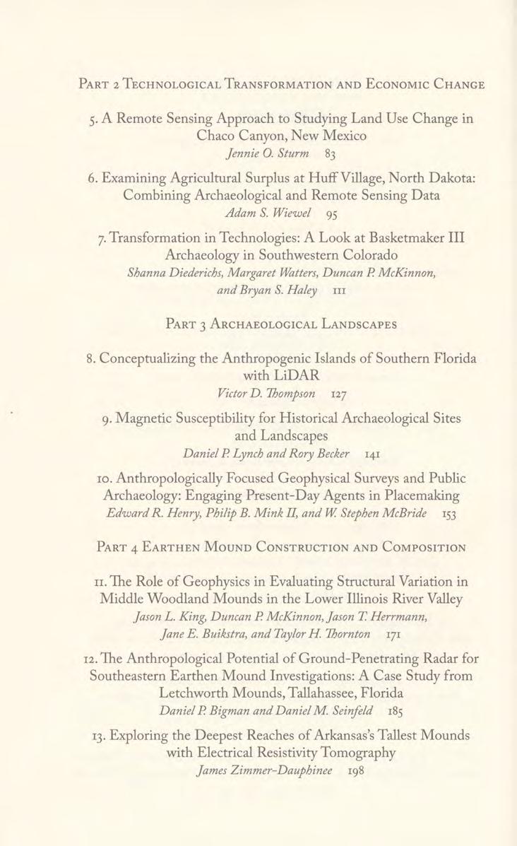
10 OPEN ACCESS: MCJA Book Reviews Volume 42, 2017 Archaeological Remote Sensing in North America: Innovative Techniques for Anthropological Applications Edited by Duncan P. McKinnon and Bryan S. Haley (2017). University of Alabama Press, 304 pages, 71 B&W figures, $59.95 (hardcover or ebook). Reviewed by Robert G. McCullough, Illinois State Archaeological Survey, Prairie Research Institute, University of Champaign at Urbana Champaign In a first look at this volume, my impression was: how can this collection of studies profess to be a comprehensive geophysical text for North America without the usual cast of characters? I was referring to various authors in the publication Remote Sensing in Archaeology: An Explicitly North American Perspective, edited by Johnson in That volume pulled together a diverse set of geophysical work from often hard-to-find manuscripts and became a handbook for the methodology of conducting geophysical surveys and data processing, as well as a reference that explained how these instruments work. In contrast, Archaeological Remote Sensing in North America: Innovative Techniques for Anthropological Applications is focused on how remote sensing can address important anthropological questions. This volume is intended to be essentially a sequel to the methods volume. Although Johnson writes an interesting reflexive Forward, and Kvamme presents a commentary for the last chapter, a newer generation of geophysical specialists dominates this volume. The goal of Archaeological Remote Sensing in North America is to move beyond creating maps of subsurface anomalies to guide future excavations. The focus of this volume is to integrate geophysical results with theory-driven anthropology. The increasing availability of geophysical equipment has encouraged a wider range of research questions that, as many of the studies here demonstrate, can only be addressed through geophysical survey. These chapters integrate cultural contexts and other types of archaeological data with feature distribution maps, allowing for broader interpretations than are possible with geophysics alone. Archaeological Remote Sensing in North America is organized by four anthropological themes, unlike the 2006 volume that was organized by geophysical methods. This organization makes sense, not only because of the theory-driven theme of this volume, but also because multiple instruments were often necessary to address specific questions related to subsurface contexts. As in any edited collection, not all the chapters are equally successful in forwarding the volume s goals, but I agree with Kvamme s commentary chapter (Chapter 14, pp ) that studies that utilize magnetic susceptibility data (Chapter 1, but especially Chapters 9 and 10) represent another of this volume s highlights and represent a major sea change in contemporary practice. In the first section, focused on Site Structure and Community Organization, three of the four chapters presented the results of wide-area magnetometer (mag) surveys of mound Copyright 2017 Midwest Archaeological Conference, Inc. All rights reserved.
11 Book Review and village/town complexes. These produced spectacular results and indeed revealed details on dynamic community organization that could only be obtained through geophysics. The mag data, however, were supplemented by other geophysical techniques and/or archival information, surface collections, and previous excavation data. Hammerstedt et al. (Chapter 1) made good use of the complementary techniques of magnetic susceptibility and soil resistivity for anomaly confirmation at Spiro. They were able to show differential usage of landforms, as well as over sixty, large circular structures in an area previously thought to have been unoccupied. Patch et al. (Chapter 2) examined two Mississippian towns in the Tennessee River Valley, revealing the settlement complexity at both sites and convincingly demonstrating a contraction of the town at Cox and sequential settlements at the Bell site. McKinnon and Haley (Chapter 3) looked at a Caddo mound and a Mississippian town (Hollywood Mounds), using surface collections and previous studies to good effect, although this reader found their use of the ethnohistorical literature a bit ex post facto. Three chapters were placed under the Technological Transformation and Economic Change theme. Strum (Chapter 5) presented a well-planned, straightforward survey of Cherto Ketl Field in Chaco Canyon that combined the use of time-series aerial photographs with subcentimeter GPS, GIS, and ground-penetrating radar (GPR), along with clear explanations of the techniques. The GPR survey was successful in identifying earlier construction intervals, a shift in orientation of lines, and different types of features in association. Wiewel s work (Chapter 6) at tightly nucleated Huff Village in North Dakota also produced excellent results by combining site-wide mag, a high resolution digital elevation model (DEM) with trend surface correction, previous excavation data, and coring. By integrating these methods, Wiewel was able to confidently estimate the size and distribution of the structures, as well as the size and placement of many of the pit features and hearths, which in turn allowed him to estimate population size, longevity, and agricultural production as a baseline for comparing sites and examining temporal trends. The Archaeological Landscapes theme included a LiDAR study by Thomson (Chapter 8) for the huge shell islands in southwest Florida covered in dense mangrove trees with fluctuating tides that limit terrestrial geophysical surveys. The other two studies focused on historic sites to test the validity of magnetic susceptibility in combination with other methods. Lynch and Becker (Chapter 9) make a major contribution by employing magnetic susceptibility, an underutilized technique, as well as soil resistivity and mag to a fort in Wyoming, a lighthouse in Michigan, and a tar kiln in North Carolina, clearly demonstrating the applicability of these techniques for research and contextual evaluation in a variety of historic settings. Henry et al. s (Chapter 10) examination of Civil War battlements in Kentucky takes a different interpretive approach. Using a public archaeology perspective, they examine how contemporary resident populations identify with historic places (place-making) and how geophysics can excite and inform this endeavor. The final theme, Earthen Mound Construction and Composition, contains three chapters that examine the internal structures of mounds, illustrating noninvasive
12 Book Review approaches to investigating these often endangered and culturally sensitive resources. Bigman and Seinfeld (Chapter 12) examined GPR radargrams from five low, sandy mounds at the Middle to Late Woodland Letchworth Mounds in Tallahassee, Florida, determining that four out of the five were constructed in a single episode. Zimmer-Dauphinee (Chapter 13) used electrical resistivity tomography (ERT) to investigate the interior of the two largest mounds (one flat-top and one conical) at the Toltec site in Arkansas. ERT is not widely understood by most American archaeologists, and credit goes to the author for his short explanation of how this technique works and the methodology employed. This study found that both mounds were originally constructed in their current shapes, but had been enlarged while maintaining the same morphology. An evaluation of structural variation in Middle Woodland mounds in the Lower Illinois River Valley by King et al. (Chapter 11) employed ERT, GPR, and mag to test for attributes of the standard model, which includes the preparation of surfaces, a varied ramp complex, a central tomb, and a final capping layer. Two of the mound groups observed by the investigators gave especially good results in detecting internal mound structure that supported the standard model. As with many of the other studies, these techniques also were useful in evaluating the degree of preservation after decades of plowing and erosion. Archaeologists have known for some time now that remote sensing has become a game changer for the preservation and interpretation of archaeological resources. The application of these techniques has provided information that would be impractical to collect with traditional methods. All the authors set up nice backgrounds to their investigations, and the results are applicable for resource evaluation and future preservation. Overall, this volume is an innovative work that demonstrates entirely new avenues for anthropological questions and presents case studies on how these techniques can be integrated with traditional archaeological data for more dynamic interpretations. I m certainly more knowledgeable for reading it. With that said, many of the chapters in this volume assume a certain level of knowledge in geophysics and may be difficult for someone expecting a how-to manual. For instance, the articles are uneven in terms of giving basic collection methodology and processing information. Some assume that standard collection intervals and processing are being used. Even though the explicit intent of this volume is the presentation of results within an anthropological framework, some basic survey and processing information would be helpful for evaluating a particular investigation or for applying it in the future. In addition, some of the anomalies discussed in text are difficult to see in the figures. In my view, with the development of new techniques, we need to see an evolution in publishing studies employing geophysical data. A larger format book and/ or electronic companion files would have enhanced this volume.
Chapter 5 LiDAR Survey and Analysis in
 Chapter 5 LiDAR Survey and Analysis in 2010-2011 Christopher Fennell A surveyor s plat and town plan filed in 1836 set out an intended grid of blocks, lots, alleys, and streets for New Philadelphia. Geophysical,
Class 4J Autumn Term St. Lucia Adapted from QCA Geography Unit 10 incorporating some elements of Unit 25
 Class 4J Autumn Term 2002 Geography St. Lucia Geography Unit 10 incorporating some elements of Unit 25 ABOUT THE UNIT In this unit children develop ideas about a less economically developed country. When
An Investigation of New Philadelphia Using Thermal Infrared Remote Sensing. (Last updated: Nov. 25, 2008)
") An Investigation of New Philadelphia Using Thermal Infrared Remote Sensing (Last updated: Nov. 25, 2008) Bryan S. Haley Center for Archaeological Research University of Mississippi Research results in
An Investigation of New Philadelphia Using Thermal Infrared Remote Sensing (Last updated: Nov. 25, 2008) Bryan S. Haley Center for Archaeological Research University of Mississippi Research results in
Class 4J Spring Term Irian Jaya/Papua New Guinea Adapted from QCA Geography Unit 10 incorporating some elements of Unit 25
 Class 4J Spring Term 2003 Geography Irian Jaya/Papua New Guinea Geography Unit 10 incorporating some elements of Unit 25 ABOUT THE UNIT In this unit children develop ideas about a less economically developed
Geoarchaeology and Geophysics at Feltus
 Geoarchaeology and Geophysics at Feltus Sarah C. Sherwood (Department of Anthropology, University of the South, Sewanee) Bryan S. Haley (Center for Archaeological Research, University of Mississippi) Jay
Application of geophysics to North American prehistoric sites
 first break volume 24, June 2006 Application of geophysics to North American prehistoric sites William J. Johnson 1 and Donald W. Johnson, 2 members of the US-based Archaeology and Geophysics Consortium,
Application of Geophysics to North American Prehistoric Sites by William J. Johnson PG 1 and Donald W. Johnson 2
 Application of Geophysics to North American Prehistoric Sites by William J. Johnson PG 1 and Donald W. Johnson 2 Introduction Archaeological geophysics, sometime called remote sensing by archaeologists,
Geophysical prospection and aerial photography in La Laguna, Tlaxcala, Mexico
 ArcheoSciences Revue d'archéométrie 33 (suppl.) 2009 Mémoire du sol, espace des hommes Geophysical prospection and aerial photography in La Laguna, Tlaxcala, Mexico Luis Barba, Jorge Blancas, Agustin Ortiz
DEPARTMENT OF GEOGRAPHY B.A. PROGRAMME COURSE DESCRIPTION
 DEPARTMENT OF GEOGRAPHY B.A. PROGRAMME COURSE DESCRIPTION (3 Cr. Hrs) (2340100) Geography of Jordan (University Requirement) This Course pursues the following objectives: - The study the physical geographical
2017/03/31. Figure 9. British military graveyard at Fort Cox. Figure 10. Memorial stone. HIA: Fort Cox College Water and Sanitation Services
 2017/03/31 Figure 9. British military graveyard at Fort Cox Figure 10. Memorial stone 22 2017/03/31 Figure 11. Memorial stone Previous Studies An extensive research into the SAHRIS database resulted in
Archaeology and Geophysics at the Chillicothe Site, Ohio, USA
 info@gemsys.on.ca Archaeology and Geophysics at the Chillicothe Site, Ohio, USA In this short paper, we summarize the recent procedings of the National Parks Service Archaeology Workshop in Chillicothe,
Archaeological Predictive Modeling within the context of Paleo-river Terraces in the City of Prince George
 Archaeological Predictive Modeling within the context of Paleo-river Terraces in the City of Prince George Background The documented pre-contact archaeological record of the Interior Plateau of B.C. is
THE USE OF GEOMATICS IN CULTURAL HERITAGE AND ARCHAEOLOGY FOR VARIOUS PURPOSES
 THE USE OF GEOMATICS IN CULTURAL HERITAGE AND ARCHAEOLOGY FOR VARIOUS PURPOSES FEBRUARY 2013 AL BEIDA GEOPLAN CONTENT Company Profile Concept Objectives and Strategies Data Production Methods Data Samples
Description of Simandou Archaeological Potential Model. 12A.1 Overview
 12A Description of Simandou Archaeological Potential Model 12A.1 Overview The most accurate and reliable way of establishing archaeological baseline conditions in an area is by conventional methods of
Laboratory Exercise 12: Exploring New World Towns and Cities with Google Earth TM
 Name: Laboratory Exercise 12: Exploring New World Towns and Cities with Google Earth TM Objectives The purpose of this lab is to allow you to explore some of the most famous and important sites in North
Using Ground Conductivity as a Geophysical Survey Technique to Locate Potential Archaeological Sites in the Bad Axe River Valley of Western Wisconsin
 Using Ground Conductivity as a Geophysical Survey Technique to Locate Potential Archaeological Sites in the Bad Axe River Valley of Western Wisconsin Anthony J. Beauchaine, Elizabeth Werdemann Faculty
Council for West Virginia Archaeology Spring Workshop Charleston, West Virginia June 7, 2003
 GEOPHYSICAL DETECTION OF GRAVES BASIC BACKGROUND AND CASE HISTORIES FROM HISTORIC CEMETERIES By William J. Johnson 1 Abstract The identification of graves is an important issue at many historical cemeteries.
Report on Geophysical Survey Na Vrsku, Sahy, Slovakia Coordinates: 48⁰,4,45 N 18⁰,56,23 E. April 2018
 Report on Geophysical Survey Na Vrsku, Sahy, Slovakia Coordinates: 48⁰,4,45 N 18⁰,56,23 E April 2018 Mark Graham BA(Hons), BSc, MA Grampus Heritage and Training Ltd, Ashgill, Threapland, Wigton, Cumbria,
Quantifying Coastal Evolution using Remote Sensing Approaches
 Quantifying Coastal Evolution using Remote Sensing Approaches Sojan Mathew, Linh Truong Hong, Xavier Pellicer*, Colman Gallagher University College Dublin Geological Survey of Ireland* INFOMAR SEMINAR,
Hazard Mapping Along the Dead Sea Shoreline
 FIG Working Week in Marrakech, Morocco 18-22 May 2011 Hazard Mapping Along the Dead Sea Shoreline Rami Al-Ruzouq, Abdullah Al-Zuobi, AbdEl-Rahman Abueladas, Emad Akkawi Department of Surveying and Geomatics
Turkey, Egypt and Italy
 Remote sensing techniques in geoarchaeological research; Case studies in Turkey, Egypt and Italy V. De Laet*, G. Verstraeten, E. Paulissen Center for Archaeological Sciences, K.U.Leuven Celestijnenlaan
Module 4 Educator s Guide Investigation 2
 Module 4 Educator s Guide Investigation 2 How do geoarchaeologists use remote sensing to interpret landscapes? Investigation Overview In this investigation students learn the seven elements geoarchaeologists
Remote Sensing Survey Preliminary Report
 Remote Sensing Survey Preliminary Report Dillard Archaeological Site, Crow Canyon, CO Figure 1 Dillard archaeological site and geophysical survey interpretations, June 2012. Submitted by: Meg Watters,
GROUND PENETRATING RADAR SURVEY OF THE NATHAN ANDERSON CEMETERY, RINGGOLD, GA. Prepared for:
 GROUND PENETRATING RADAR SURVEY OF THE NATHAN ANDERSON CEMETERY, RINGGOLD, GA Prepared for: Marshall Bandy Nathan Anderson Cemetery 15 Nyoka Trail Ringgold, GA 30736 Prepared by: Daniel P. Bigman, PhD
MINNESOTA DEEP TEST PROTOCOL PROJECT
 MINNESOTA DEEP TEST PROTOCOL PROJECT Mn/DOT Agreement No. 85878 OSA License No. 04-030 Authorized and Sponsored by: MINNESOTA DEPARTMENT OF TRANSPORTATION FEDERAL HIGHWAY ADMINISTRATION Prepared by COMMONWEALTH
UNITED NATIONS E/CONF.96/CRP. 5
 UNITED NATIONS E/CONF.96/CRP. 5 ECONOMIC AND SOCIAL COUNCIL Eighth United Nations Regional Cartographic Conference for the Americas New York, 27 June -1 July 2005 Item 5 of the provisional agenda* COUNTRY
EXTREMELY FAST IP USED TO DELINEATE BURIED LANDFILLS. Norman R. Carlson, Cris Mauldin Mayerle, and Kenneth L. Zonge
 EXTREMELY FAST IP USED TO DELINEATE BURIED LANDFILLS Norman R. Carlson, Cris Mauldin Mayerle, and Kenneth L. Zonge Zonge Engineering and Research Organization, Inc. 3322 East Fort Lowell Road Tucson, Arizona,
Tuition, Medical and Behaviour Support Service
 Tuition, Medical and Behaviour Support Service Curriculum Policy - Primary Geography Reviewed: October 2018 Next Review: October 2019 Responsibility: Andrea Snow AIMS AND PRINCIPLES The national curriculum
PREVIEW AUSTRALIAN SOCIETY OF OF EXPLORATION GEOPHYSICISTS
 AUGUST 9 ISSUE 11 ABN 71 876 ISSN 13-71 AUSTRALIAN SOCIETY OF OF EXPLORATION GEOPHYSICISTS NEWS AND COMMENTARY Geophysics on TV Guest Editorial Science and the 9 Federal Budget New offshore petroleum exploration
Mutah university faculty of Social Sciences The Study plan of the department of Geography 2006/2007
 Mutah university faculty of Social Sciences The Study plan of the department of Geography 2006/2007 Requirements university compulsory 22 Credit hours Course No Credit hours Prerequisite Requirements Faculty
Bus 15 will take you from Groningen railway station to the Zernike Campus in about 15 minutes.
 1 Bus 15 will take you from Groningen railway station to the Zernike Campus in about 15 minutes. 2 PROGRAMME 10.00-10.30 Registration 10.30-10.45 Opening by Peter Attema & Frans van Hoesel 10.45-11.20
Remote Sensing and Geographic Information System (GIS) Based Analysis of Historic Resources
 Based Analysis of Historic Resources") World War II Additional Material Remote Sensing and Geographic Information System (GIS) Based Analysis of Historic Resources By Nicole Vernon and Patrick O Day, GANDA Remote Sensing and Geographic Information
World War II Additional Material Remote Sensing and Geographic Information System (GIS) Based Analysis of Historic Resources By Nicole Vernon and Patrick O Day, GANDA Remote Sensing and Geographic Information
ACTON COMMUNITY WIDE ARCHAEOLOGICAL RECONNAISSANCE SURVEY. Town of Acton and PAL, Inc.
 ACTON COMMUNITY WIDE ARCHAEOLOGICAL RECONNAISSANCE SURVEY Town of Acton and PAL, Inc. Objectives and Scope of Work Four phase study; (1. research, 2. draft report outline, resource protection bylaw, 3.
Geophysical Survey of Wisconsin Burial Site BRO-0033 Wixom Cemetery, Rock County, Wisconsin
 Lawrence University Lux Archaeological Reports Anthropology Department 6-2015 Geophysical Survey of Wisconsin Burial Site BRO-0033 Wixom Cemetery, Rock County, Wisconsin Peter N. Peregrine Lawrence University
In 1998, salvage archaeological investigations began on the bank of the Miami River
 1 Imaging Sub-surface Features of the Miami Circle with Ground Penetrating Radar Jessie Pincus a, Robert S. Carr b, Dean Whitman c Ground Penetrating Radar (GPR) is a high-resolution near-surface geophysical
Geography Policy 2014
 Geography Policy 2014 DEFINITION Geography education should inspire in pupils a curiosity and fascination about the world and its people that will remain with them for the rest of their lives. Teaching
GIS Visualization: A Library s Pursuit Towards Creative and Innovative Research
 GIS Visualization: A Library s Pursuit Towards Creative and Innovative Research Justin B. Sorensen J. Willard Marriott Library University of Utah justin.sorensen@utah.edu Abstract As emerging technologies
United States Natural Resources 344 Merrow Road Department of Conservation Service Suite A Agriculture Service Tolland, CT 06084
 United States Natural Resources 344 Merrow Road Department of Conservation Service Suite A Agriculture Service Tolland, CT 06084 SUBJECT: Archaeology Geophysical Field Assistance January 6, 2015 TO: Dr.
Location, Location, Location: the Construction and Preservation of Roman Burial Mounds in the Dutch River Delta
 Special Volume 3 (2012), pp. 155 159 Marjolein T.I.J. Bouman Kirsten van Kappel Linda P. Verniers Location, Location, Location: the Construction and Preservation of Roman Burial Mounds in the Dutch River
A GPR ASSESSMENT OF THE PREHISTORIC NAPLES CANAL NAPLES, FLORIDA ARCHAEOLOGICAL AND HISTORICAL CONSERVANCY, INC.
 A GPR ASSESSMENT OF THE PREHISTORIC NAPLES CANAL NAPLES, FLORIDA ARCHAEOLOGICAL AND HISTORICAL CONSERVANCY, INC. AHC TECNICAL REPORT NO. 1004 DECEMBER 2013 A GPR ASSESSMENT OF THE PREHISTORIC NAPLES CANAL
GEOPHYSICAL SURVEY REPORT. Timolin, County Kildare. Date: 18/01/2016. Licence: 15R0133
 GEOPHYSICAL SURVEY REPORT Date: 18/01/2016 Licence: 15R0133 J. M. Leigh Surveys 124 Oaklawn West Leixlip County Kildare www.jmlsurveys.com 01 615 4647 Consultants. J. M. Leigh Surveys 124 Oaklawn West,
Cultural Geographies Old and New
 Cultural Geographies Old and New GG270 Winter 2013 Dr Margaret Walton-Roberts COURSE OBJECTIVES Survey the development of cultural geography from early environmental approaches, to more recent examinations
A Correlation of. Eastern Hemisphere. Ohio s Learning Standards Social Studies: K-12 Grade 6
 A Correlation of Eastern Hemisphere To Grade 6 to,, Grade 6 Introduction This document demonstrates how, Eastern Hemisphere, Ohio Edition, meets : K-12 Social Studies for Grade 6. Correlation page references
Tecate Commercial Vehicle Enforcement Facility Project: Increasing Efficiency of Geophysical Survey Billy A. Silva
 Tecate Commercial Vehicle Enforcement Facility Project: Increasing Efficiency of Geophysical Survey Billy A. Silva Introduction A geophysical survey of CA-SDI-16,798 in San Diego County, California was
Ground Penetrating Radar Survey Report: Follow-up Ground Truth Study
 Ground Penetrating Radar Survey Report: Follow-up Ground Truth Study 2005 Tell es-safi/gath Archaeological Project Figure 1: Tell es-safi GPR ground-truth study. Data Acquired August 4, 2005 Report compiled
World Geography and Cultures Michigan Social Studies Grade Six Content Expectations - Geography
 World Geography and Cultures 2008 Correlated to Michigan Social Studies Grade Six Content Expectations - Geography 5910 Rice Creek Pkwy, Suite 1000 Shoreview, MN 55126 Copyright 2007 Pearson Education,
New Research Exploring the Origins of Sanxingdui
 New Research Exploring the Origins of Sanxingdui The Harvard community has made this article openly available. Please share how this access benefits you. Your story matters. Citation Published Version
Archaeological Glossary
 Archaeological Glossary analysis: the stage of archaeological research that involves the description and classification of archaeological data. anthropology: the study of humans, including the variety
A GPR ASSESSMENT OF THE NAPLES CANAL 8CR59: PHASE II NAPLES, FLORIDA ARCHAEOLOGICAL AND HISTORICAL CONSERVANCY, INC.
 A GPR ASSESSMENT OF THE NAPLES CANAL 8CR59: PHASE II NAPLES, FLORIDA ARCHAEOLOGICAL AND HISTORICAL CONSERVANCY, INC. AHC TECNICAL REPORT NO. 1023 JUNE 2014 A GPR ASSESSMENT OF THE NAPLES CANAL 8CR59: PHASE
Pierce Cedar Creek Institute GIS Development Final Report. Grand Valley State University
 Pierce Cedar Creek Institute GIS Development Final Report Grand Valley State University Major Goals of Project The two primary goals of the project were to provide Matt VanPortfliet, GVSU student, the
An Introduction to Geographic Information System
 An Introduction to Geographic Information System PROF. Dr. Yuji MURAYAMA Khun Kyaw Aung Hein 1 July 21,2010 GIS: A Formal Definition A system for capturing, storing, checking, Integrating, manipulating,
Artificial and Real Prehistoric Worlds: Agent Based Modeling in the Prehistoric American Southwest
 Artificial and Real Prehistoric Worlds: Agent Based Modeling in the Prehistoric American Southwest Archaeology: The only discipline with the time range to study long-term culture change. Impossible to
DOWNLOAD PDF THE GEOGRAPHICAL INTERPRETATION OF TOPOGRAPHICAL MAPS.
 Chapter 1 : Topography - Wikipedia â Topographical maps are large-scale maps, they show a great deal of details about the relief. â In Topographical survey, actual survey is carried out and different methods
GEOGRAPHY (GE) Courses of Instruction
 Courses of Instruction") GEOGRAPHY (GE) GE 102. (3) World Regional Geography. The geographic method of inquiry is used to examine, describe, explain, and analyze the human and physical environments of the major regions of the
GEOGRAPHY (GE) GE 102. (3) World Regional Geography. The geographic method of inquiry is used to examine, describe, explain, and analyze the human and physical environments of the major regions of the
The Contested Cultural Landscape of a Lebanese Border Town: MARJA AYOUN
 The Contested Cultural Landscape of a Lebanese Border Town: MARJA AYOUN IBD 2013 FNAS MAY 2013 Dr. Christine Mady, City & Regional Planning NDU -FAAD In this Presentation A PLANNING PERSPECTIVE INTRODUCING
May 18, Dear AP Human Geography Student,
 May 18, 2018 Dear AP Human Geography Student, This fall many exciting challenges and opportunities await you in AP Human Geography. As the title indicates, this is a college-level course. Its format follows
Grade 5: Social Studies Practices
 Grade 5: Social Studies Practices A. Gathering and Using Evidence 1. Develop questions to help identify evidence about topics related to the historical events occurring in the Western Hemisphere that can
Geography involves the study of places: their locations, their characteristics, and how humans use and move around them.
 Physical Geography Looking at the Earth Geography involves the study of places: their locations, their characteristics, and how humans use and move around them. NEXT Physical Geography Looking at the Earth
Elizabeth Cory Sills
 Elizabeth Cory Sills Department of Social Sciences The University of Texas at Tyler 3900 University Boulevard Tyler, Texas 75799 Email:e.corysills@gmail.com Phone:214-683-5161 Education Louisiana State
Hourly Precipitation Data Documentation (text and csv version) February 2016
 February 2016") I. Description Hourly Precipitation Data Documentation (text and csv version) February 2016 Hourly Precipitation Data (labeled Precipitation Hourly in Climate Data Online system) is a database that gives
I. Description Hourly Precipitation Data Documentation (text and csv version) February 2016 Hourly Precipitation Data (labeled Precipitation Hourly in Climate Data Online system) is a database that gives
Application of Magnetic Method and Electrical Resistivity Tomography for Imaging Archaeological Structures at Iyekere, Ile-Ife Southwestern Nigeria
 Summary Application of Magnetic Method and Electrical Resistivity Tomography for Imaging Archaeological Structures at Iyekere, Ile-Ife Southwestern Nigeria K. D. Oyeyemi 1, M.A Oladunjoye 2, A.I Olayinka
Image Interpretation and Landscape Analysis: The Verka River Valley
 Image Interpretation and Landscape Analysis: The Verka River Valley Terms of reference Background The local government for the region of Scania has a need for improving the knowledge about current vegetation
N04/3/GEOGR/HP2/ENG/TZ0/XX/Q+ GEOGRAPHY HIGHER LEVEL PAPER 2. Tuesday 16 November 2004 (morning) 2 hours 30 minutes INSTRUCTIONS TO CANDIDATES
 2 hours 30 minutes INSTRUCTIONS TO CANDIDATES") IB GEOGRAPHY HIGHER LEVEL PAPER 2 DIPLOMA PROGRAMME PROGRAMME DU DIPLÔME DU BI PROGRAMA DEL DIPLOMA DEL BI 88045202 Tuesday 16 November 2004 (morning) 2 hours 30 minutes INSTRUCTIONS TO CANDIDATES Do not
IB GEOGRAPHY HIGHER LEVEL PAPER 2 DIPLOMA PROGRAMME PROGRAMME DU DIPLÔME DU BI PROGRAMA DEL DIPLOMA DEL BI 88045202 Tuesday 16 November 2004 (morning) 2 hours 30 minutes INSTRUCTIONS TO CANDIDATES Do not
Exploring Geography. Chapter 1
 Exploring Geography Chapter 1 The Study of Geography Geography is the study of where people, places, and things are located and how they relate to each other. Greek meaning writing about or describing
Glossary of Common Terms. Guide 2. BAJR Practical Guide Series held by authors
 Glossary of Common Terms Guide 2 BAJR Practical Guide Series 2008 held by authors Glossary of common archaeological terms : compiled 28/04/2004 absolute dating: Absolute dating is based upon a specific
Spatial Model of the First Bulgarian Capital Pliska Based on Remote Sensing and Ground- Based Data. Stefan Stamenov, Bulgaria
 Spatial Model of the First Bulgarian Capital Pliska Based on Remote Sensing and Ground- Based Data Stefan Stamenov, Bulgaria 1 Location of the study area 2 PURPOSE OF THE STUDY The purpose of this paper
Technical Proposal for: A Remote-Sensing Survey of the Maple Leaf Site Located in the St. Johns River Jacksonville, Florida.
 Technical Proposal for: A Remote-Sensing Survey of the Maple Leaf Site Located in the St. Johns River Jacksonville, Florida Submitted to: St. Johns Archaeological Expeditions, LLC 4114 Herschel Street,
ST AMBROSE CATHOLIC PRIMARY SCHOOL Geography Policy
 ST AMBROSE CATHOLIC PRIMARY SCHOOL Geography Policy 2017-2018 Our school policy is developed in accordance with the National Curriculum for Geography and Foundation Stage Curriculum for Understanding of
A Street Named for a King
 A Street Named for a King Dr. Jerry Mitchell University of South Carolina OVERVIEW This lesson adapts the work of Dr. Derek Alderman, a geographer who has used the Martin Luther King, Jr. street-naming
ENVIRONMENT AND NATURAL RESOURCES 3700 Introduction to Spatial Information for Environment and Natural Resources. (2 Credit Hours) Semester Syllabus
 Semester Syllabus") ENVIRONMENT AND NATURAL RESOURCES 3700 Introduction to Spatial Information for Environment and Natural Resources COURSE INSTRUCTOR: Dr. Kris Jaeger Assistant Professor 359 Kottman Hall (Mondays and Tuesdays)
ENVIRONMENT AND NATURAL RESOURCES 3700 Introduction to Spatial Information for Environment and Natural Resources COURSE INSTRUCTOR: Dr. Kris Jaeger Assistant Professor 359 Kottman Hall (Mondays and Tuesdays)
GIS APPLICATIONS IN SOIL SURVEY UPDATES
 GIS APPLICATIONS IN SOIL SURVEY UPDATES ABSTRACT Recent computer hardware and GIS software developments provide new methods that can be used to update existing digital soil surveys. Multi-perspective visualization
Exploring Geography. Chapter 1. Chapter 1, Section
 Chapter 1, Section World Geography Chapter 1 Exploring Geography Copyright 2003 by Pearson Education, Inc., publishing as Prentice Hall, Upper Saddle River, NJ. All rights reserved. Chapter 1, Section
Advanced Placement Human Geography
 Advanced Placement Human Geography Introduction to AP Human Geography The Advanced Placement course in Human Geography is designed to introduce students to the systematic study of the processes that have
Aerial Photography and Parcel Mapping for Immovable Property Registration in Albania
 No. 10 A L B A N I A S E R I E S September 1997 Aerial Photography and Parcel Mapping for Immovable Property Registration in Albania Maksimiljan Gjika and Edmond Leka AERIAL PHOTOGRAPHY AND PARCEL MAPPING
Exploring the boundaries of your built and natural world. Geomatics
 Exploring the boundaries of your built and natural world Geomatics Before the Luxor brought magic to the Las Vegas strip and before the South LRT extension in Edmonton gave residents a new route to travel,
Level 2 Geography, 2014
 91240 912400 2SUPERVISOR S Level 2 Geography, 2014 91240 Demonstrate geographic understanding of a large natural environment 2.00 pm Monday 10 November 2014 Credits: Four Achievement Achievement with Merit
Colorado Academic Standards for High School Science Earth Systems Science
 A Correlation of Pearson 12 th Edition 2015 Colorado Academic Standards Introduction This document demonstrates the alignment between, 12 th Edition, 2015, and the, Earth Systems Science. Correlation page
Marl Prairie vegetation response to 20th century land use and its implications for management in the Everglades
 Marl Prairie vegetation response to 20th century land use and its implications for management in the Everglades C. Bernhardt, D. Willard, B. Landacre US Geological Survey Reston, VA USA U.S. Department
GEOGRAPHY POLICY STATEMENT. The study of geography helps our pupils to make sense of the world around them.
 GEOGRAPHY POLICY STATEMENT We believe that the study of geography is concerned with people, place, space and the environment and explores the relationships between the earth and its peoples. The study
2.0 Research Project Design
 2.0 Research Project Design This chapter is presented in two parts. Firstly, Section 2.1 summarises the research methodology concerning the collecting and immediate processing of data for this research
Kirsten Vacca NRS 509 December 6, GIS and Archaeology
 GIS and Archaeology Kirsten Vacca Archaeologists have developed multiple uses for Geographic Information Systems (GIS) since the inception of this groundbreaking technology. Applications for GIS research
Combined Geophysical Survey of an Ancient Hittite Dam: New and Old High-Tech
 Geophysical Prospecting 1 Ercan Erkul Andreas Hüser Harald Stümpel Tina Wunderlich Combined Geophysical Survey of an Ancient Hittite Dam: New and Old High-Tech Abstract: Investigating ancient living conditions
GEOGRAPHY (GEOGRPHY) Geography (GEOGRPHY) 1
 Geography (GEOGRPHY) 1") Geography (GEOGRPHY) 1 GEOGRAPHY (GEOGRPHY) GEOGRPHY 1040 Planet Earth 4 Credits The features of the natural environment (lithosphere, atmosphere and hydrosphere); their character, distribution, origin
Geography (GEOGRPHY) 1 GEOGRAPHY (GEOGRPHY) GEOGRPHY 1040 Planet Earth 4 Credits The features of the natural environment (lithosphere, atmosphere and hydrosphere); their character, distribution, origin
GEOTECHNICAL ENGINEERING II. Subject Code : 06CV64 Internal Assessment Marks : 25 PART A UNIT 1
 GEOTECHNICAL ENGINEERING II Subject Code : 06CV64 Internal Assessment Marks : 25 PART A UNIT 1 1. SUBSURFACE EXPLORATION 1.1 Importance, Exploration Program 1.2 Methods of exploration, Boring, Sounding
General Editor: Vince Russett
 YCCCART 2014/Y20 North Somerset HER 2015/11 Manual survey using an electronic, hydryostatic level (NIVCOMP) at Wemberham Roman Villa YATTON, CONGRESBURY, CLAVERHAM AND CLEEVE ARCHAEOLOGICAL RESEARCH TEAM
GEOPHYSICAL PROSPECTION IN THE CADE ARCHAEOLOGICAL DISTRICT OF VERNON COUNTY, WISCONSIN
 GEOPHYSICAL PROSPECTION IN THE CADE ARCHAEOLOGICAL DISTRICT OF VERNON COUNTY, WISCONSIN STEPHANIE M. SULLIVAN A SENIOR THESIS SUBMITTED IN PARTIAL FULFILLMENT OF THE REQUIREMENTS FOR THE DEGREE OF BACHELOR
THE ARFORDIR COASTAL HERITAGE SITE RECORDING FORM
 THE ARFORDIR COASTAL HERITAGE SITE RECORDING FORM Information to assist with filling in the form Why do we need to use the form? Archaeology is not only about finding things, but about telling others about
Jakarta International School 6 th Grade Formative Assessment Graphing and Statistics -Black
 Jakarta International School 6 th Grade Formative Assessment Graphing and Statistics -Black Name: Date: Score : 42 Data collection, presentation and application Frequency tables. (Answer question 1 on
Geography. Programme of study for key stage 3 and attainment target (This is an extract from The National Curriculum 2007)
") Geography Programme of study for key stage 3 and attainment target (This is an extract from The National Curriculum 2007) Crown copyright 2007 Qualifications and Curriculum Authority 2007 Curriculum aims
Geography Programme of study for key stage 3 and attainment target (This is an extract from The National Curriculum 2007) Crown copyright 2007 Qualifications and Curriculum Authority 2007 Curriculum aims
A303 Stonehenge Amesbury to Berwick Down Archaeological Geophysical Survey Design Brief
 A303 Stonehenge Amesbury to Berwick Down Archaeological Geophysical Survey Design Brief March 2016 Table of contents Chapter Pages 1 Summary 1 2 Background 1 2.1 Purpose 1 2.2 Location 2 2.3 Archaeological
Correction to Spatial and temporal distributions of U.S. winds and wind power at 80 m derived from measurements
 JOURNAL OF GEOPHYSICAL RESEARCH, VOL. 109,, doi:10.1029/2004jd005099, 2004 Correction to Spatial and temporal distributions of U.S. winds and wind power at 80 m derived from measurements Cristina L. Archer
CLLD Cooperation OFFER
 Title of the proposed project (English) CLLD Cooperation OFFER PARKS PROTECTION III - Management, Protection and Economic Development in Protected Areas Type of project (select as many as you want) Cooperation
AGRY 545/ASM 591R. Remote Sensing of Land Resources. Fall Semester Course Syllabus
 AGRY 545/ASM 591R Remote Sensing of Land Resources Fall Semester 2005 Course Syllabus Agronomy 545/ASM 591R is a graduate level course designed to teach students how to analyze and interpret remotely sensed
18 September 2015 Volume 1 Issue 24
 18 September 2015 Volume 1 Issue 24 THE SNOWMAN, THE KID AND SOL Water resources in the western United States are an intersection of climate, precipitation and temperature. In good years, each plays well
Late Bronze Age to Middle Iron Age Research topics and priorities
 Methodological approaches and cross-cutting themes These issues are relevant to several of the topics and priorities to be considered and discussed during the workshops. They will not form the focus of
MEANDER MIGRATION MODEL ASSESSMENT FOR THE JANUARY 2005 STORM, WHITMAN PROPERTY, SAN ANTONIO CREEK, VENTURA COUNTY, CALIFORNIA
 MEANDER MIGRATION MODEL ASSESSMENT FOR THE JANUARY 2005 STORM, WHITMAN PROPERTY, SAN ANTONIO CREEK, VENTURA COUNTY, CALIFORNIA Prepared by Eric Larsen, Ph.D. Mark Rains, Ph.D. October 2006 INTRODUCTION
3D GPR Mapping for Excavation Plan in Jeniang, Kedah, Malaysia
 3D GPR Mapping for Excavation Plan in Jeniang, Kedah, Malaysia Norhidayahti Mohd. Muztaza, M. Mokhtar Saidin, I. N. Azwin, and S. Rosli without any further archeological research of the structures [4].
Coastal Systems and Landscapes 3 days
 AS Level Geography WJEC Coastal Systems and Landscapes 3 days This course is for Welsh schools. This in-depth course prepares students for the physical fieldwork focusing on the Coastal option, for Section
2007 Raleigh Colony Investigation: Magnetic Anomaly Identification & Assessment Roanoke Sound and Shallowbag Bay Roanoke Island, North Carolina
 2007 Raleigh Colony Investigation: Magnetic Anomaly Identification & Assessment Roanoke Sound and Shallowbag Bay Roanoke Island, North Carolina 2007 Raleigh Colony Investigation: Magnetic Anomaly Identification
of a landscape to support biodiversity and ecosystem processes and provide ecosystem services in face of various disturbances.
 L LANDSCAPE ECOLOGY JIANGUO WU Arizona State University Spatial heterogeneity is ubiquitous in all ecological systems, underlining the significance of the pattern process relationship and the scale of