Inventory of Soil Resources of Narmada District, Gujarat Using Remote Sensing and GIS Techniques
|
|
|
- Anthony Beasley
- 5 years ago
- Views:
Transcription
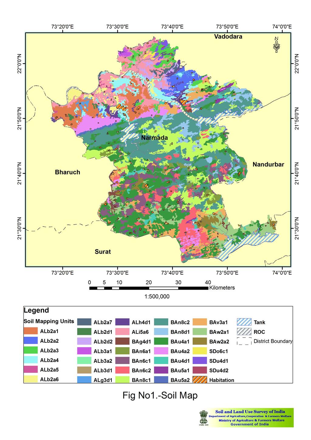
1 Inventory of Soil Resources of Narmada District, Gujarat Using Remote Sensing and GIS Techniques ABSTRACT 1. Survey Area Narmada district, Gujarat 2. Geographical Extent and East Longitude and and North Latitude 3. Agro Climate Region XIII- Gujarat plain and hills 4. Total area of the district 3,09,541 ha. 5. Kind of Survey Soil Resource Mapping using remote sensing techniques and GIS techniques 6. Base map (a)irs-id Geocoded Satellite Imagery (1:50,000 Scale) (b) SOI Toposheet ( 1:50,000 scale ) 7. Scale of mapping 1: 50, Period of survey Dec,2008 to Feb, Soil Series association mapped and their respective area. Sl. No Mapping Unit Series Association Area (%) Area (%) A01 ALb2a1 Sajod-Thasra A02 ALb2a2 Varnol-Sajod A03 ALb2a3 Sajod-Varnol A04 ALb2a4 Thasra-Sajod-Varnol A05 ALb2d1 Thasra-Kawa-Sajod A06 ALb2d2 Kawa-Sajod A07 ALg3d1 Malitha-Rumalpura A08 ALb2a5 Thasra-Sajod A09 ALh4d1 Rumalpura-Mulad A10 ALi5a6 Derol-Rumalpura A11 ALb2a6 Rumalpura-Thasra A12 ALb3a1 Bariya-Borsad-Rumalpura A13 ALb3a2 Borsad-Bariya A14 ALb3d1 Rumalpura-Borsad A15 ALb2a7 Varnol-Thasra B01 BAn8c1 Kavachiya-Dungra B02 BAn8c2 Dungra-Kavachiya B03 BAn8d1 Kavachiya-Dungra B04 BAn6c1 Kavachiya-Dungra B05 BAn6c2 Dungra-Kavachiya B06 BAn6a1 Kavachiya-Dungra B07 BAu5a1 Jambar B08 BAu4a1 Jambar B09 BAu4d1 Jambar B10 BAv3a1 Chandravan-Kadaba B11 BAw2a1 Sagbara-Chandeliya B12 BAw2a2 Chandeliya-Sagbara i
2 Sl. No Mapping Unit Series Association Area (%) Area (%) B13 BAg4d1 Kadaba-Chandeliya B14 BAu4a2 Chandeliya-Kadaba B15 BAu5a2 Jambar B16 BAn8c2 Kavachiya-Dungra S01 SDo6c1 Naswadi-Kothiya S02 SDu4d1 Chametha-Godham S04 SDu4d2 Nanakothiya H R T Physiography wise Distribution of area and their percentage. Landscape Physiography Area (ha) Area (%) Alluvium Alluvial plains Dissected stream banks Ravinous lands Stream banks Basalt Lower pediplains Narrow mountain valleys Pediments Undifferentiated hills side slope Upper pediplains Sandstone Foot hill slopes Pediments Misc Slope wise Distribution of area and their percentage. Slope Classes Area(ha) Area (%) Nearly level to very gently sloping Very gently sloping to gently sloping Gently sloping to moderately sloping Moderately sloping to strongly sloping Strongly sloping to moderately steep Steep to very steep ii
3 12. Depth wise Distribution of area and their percentage. Depth Area (ha) Area (%) Shallow Shallow to moderately deep Moderately deep to deep Deep to very deep Very deep Various land use / Land cover wise Distribution of area and their percentage. Land use Area (ha) Area (%) Agriculture Forest Open scrub Soil under Different Erosion Classes. Erosion Area (ha) Area (%) None to slight erosion Slight to moderate erosion Moderate to severe erosion Severe water erosion Severe to very severe erosion Soil under Different Land Capability Classes. Land Capability Class Area (ha) Area (%) II III II-III III-IV IV IV-VI VI VII-VIII Forest % iii
4 10. Salient Features: Total 24 soil series have been mapped in Narmada district of Gujarat. Out of total area of 3,09,541 ha shallow soils have maximum coverage occupying 1,71,970 ha (55.56%) followed by very deep soils with area of 6, 9142 ha (22.34%), deep to very deep soils 29,328 ha (9.47%), moderately deep to deep 13,219 ha (4.27) %), shallow to moderately deep 1161 ha (0.38%), miscellaneous land occupy 24,721 ha (7.99%). Agricultural land covers an area of 1,53,613 ha (49.63%), followed by forest land 1,06,640 ha (34.45%) and open scrub 24, 567 (7.94%). Physiography of Narmada district is having mainly ten physiographic units. iv
5
6 HOW TO USE SOIL RESOURCE MAPPING REPORT This report embodies the results of the soil resource mapping of Narmada district of Gujarat providing information on the geographical setting of the district, such as location, extent, physiography, relief, drainage, climate, geology, natural vegetation, agriculture, land use & soils. The report contains other information on interpretative grouping of soils such as land capability classes; land irritability classes, soil suitability grouping and hydrological grouping and also recommendation for crops ; horticulture development, forest, forage and grasslands development; water harvesting, water storage and water management that are essential for soil land resource management. The genesis and classification of the soils are also discussed in chapter-5. Narmada district of Gujarat is spread over an area of 3,09, ha. The district is covered by - SOI topographical sheets on the scale of 1:50,000 which are used as base material along with satellite imageries. Each soil mapping unit is marked by mapping unit i.e. Alb2a1 (Alluvium, alluvial plain; 0-3% slope; agriculture land use; soil series Association, describing Sajod as dominant series in association with Varnol, Thasra & Kawa series). Each soil association is restricted to maximum of three soil series. For the use of the soil resource mapping report, first locate the area of your interest on the map. For the detailed information on soil mapping unit in respect of soil series of the area of interest, its extent, present and proposed land uses, and reference may be made to chapter-4, appendix I and II. The mapping unit used in soil mapping represents the five levels of mapping i.e. Alb2a1 may be referred as follow: AL - Alluvium - Landscape b - Alluvium plain - Physiography % - Slope class a - Agriculture land - Land use 1 - Association of soil series with erosion and management soil unit. Any comment and suggestion on the report would be welcome. For any further enquiry/or clarification, correspondence or personal contact may be established, with the Chief Soil Survey Officer, Soil Survey Officer, Soil & Land Use Survey of India Soil & Land Use Survey of India IARI Buildings, Pusa, Opp. Godavari Flats, Vasna New Delhi Ahehmdabad csso- slusi@ nic. in ssoahmedabad- slusi@ nic. in Ph Ph Website: v
Inventory of Soil Resources of Dhalai District, Tripura State Using Remote Sensing and GIS Techniques
 Inventory of Soil Resources of Dhalai District, Tripura State Using Remote Sensing and GIS Techniques ABSTRACT. Survey : Dhalai District, Tripura 2. Geographical Extent : Between 23 o 24 to 24 o North
Inventory of Soil Resources of Dimapur District, Nagaland State Using Remote Sensing and GIS Techniques
 Inventory of Soil Resources of Dimapur District, Nagaland State Using Remote Sensing and GIS Techniques ABSTRACT 1. Survey : Dimapur District, Nagaland 2. Geographical Extent : Between 93 o 30ꞌ54 ꞌꞌ and
INVENTORY OF SOIL & LAND RESOURCES OF NALGONDA DISTRICT, TELANGANA STATE USING REMOTE SENSING TECHNIQUES
 INVENTORY OF SOIL & LAND RESOURCES OF NALGONDA DISTRICT, TELANGANA STATE USING REMOTE SENSING TECHNIQUES ABSTRACT 1. Survey Area : Nalgonda District,Telangana State, India 2. Geographical Extent : 78 40
ABSTRACT. 2. Location : 31 o 04'16'' to 32 o 31'27'' North Latitudes and 74 o 30'38'' to 76 o 08'45'' East Longitudes
 ABSTRACT 1. Surveyed Area : Prioritization of Microwatersheds of Beas Catchment (1B1) of Districts-Amritsar, Firozpur, Gurdaspur, Hoshiarpur, Jalandhar, Kapurthala, Tarntaran, Punjab State and Districts-
Report on Soil Resource Mapping of District Kangra, Himachal Pradesh
 Report on Soil Resource of District Kangra, Himachal Pradesh Abstract 1. Surveyed area : Kangra district, Himachal Pradesh 2. Total area : 5,74,763 ha 3. Geographical Extent : 31 21 & 32 59 North latitude
[Penumaka, 7(1): January-March 2017] ISSN Impact Factor
![[Penumaka, 7(1): January-March 2017] ISSN Impact Factor](/thumbs/95/124653515.jpg "[Penumaka, 7(1): January-March 2017] ISSN Impact Factor") INTERNATIONAL JOURNAL OF ENGINEERING SCIENCES &MANAGEMENT HYDROGEOMORPHOLOGY OF CHEVELLA BASIN, RANGA REDDY DISTRICT, TELANGANA STATE Penumaka Ramesh* 1 & Podila Sankara Pitchaiah 2 * 1&2 Department of
INTERNATIONAL JOURNAL OF ENGINEERING SCIENCES &MANAGEMENT HYDROGEOMORPHOLOGY OF CHEVELLA BASIN, RANGA REDDY DISTRICT, TELANGANA STATE Penumaka Ramesh* 1 & Podila Sankara Pitchaiah 2 * 1&2 Department of
INTERNATIONAL JOURNAL OF GEOMATICS AND GEOSCIENCES Volume 2, No 1, 2011
 INTERNATIONAL JOURNAL OF GEOMATICS AND GEOSCIENCES Volume 2, No 1, 2011 Copyright 2010 All rights reserved Integrated Publishing services Research article ISSN 0976 4380 Hypsometric Analysis of Varattaru
Report on Soil Resource Mapping of District Shimla, Himachal Pradesh. Abstract
 Report on Soil Resource Mapping of District Shimla, Himachal Pradesh Abstract 1. Surveyed area : Shimla district, Himachal Pradesh 2. Total area : 5,14,320 ha 3. Geographical Extent : 4. Kind of Survey
GROUNDWATER CONFIGURATION IN THE UPPER CATCHMENT OF MEGHADRIGEDDA RESERVOIR, VISAKHAPATNAM DISTRICT, ANDHRA PRADESH
 GROUNDWATER CONFIGURATION IN THE UPPER CATCHMENT OF MEGHADRIGEDDA RESERVOIR, VISAKHAPATNAM DISTRICT, ANDHRA PRADESH Prof.P.Jagadeesara Rao Department of Geo-Engineering and Centre for Remote Sensing, College
Abstract: About the Author:
 REMOTE SENSING AND GIS IN LAND USE PLANNING Sathees kumar P 1, Nisha Radhakrishnan 2 1 1 Ph.D Research Scholar, Department of Civil Engineering, National Institute of Technology, Tiruchirappalli- 620015,
Report for Area Drainage Studies for 1320 MW (2x660 MW) THERMAL POWER PROJECT AT MIRZAPUR, U.P.
 THERMAL POWER PROJECT AT MIRZAPUR, U.P.") Report for Area Drainage Studies for 1320 MW (2x660 MW) THERMAL POWER PROJECT AT MIRZAPUR, U.P. 1. Introduction M/s Welspun Energy Uttar Pradesh Ltd. (WEUPL) is putting up 1320 MW (2 x 660 MW) coal fired
Report for Area Drainage Studies for 1320 MW (2x660 MW) THERMAL POWER PROJECT AT MIRZAPUR, U.P. 1. Introduction M/s Welspun Energy Uttar Pradesh Ltd. (WEUPL) is putting up 1320 MW (2 x 660 MW) coal fired
Ground Water Potential Mapping in Chinnar Watershed (Koneri Sub Watershed) Using Remote Sensing & GIS
 Using Remote Sensing & GIS") Ground Water Potential Mapping in Chinnar Watershed (Koneri Sub Watershed) Using Remote Sensing & GIS T.Velmurugan 1 Dr.D.Srinivasan 2 1 Assistant professor/civil, Roever Engineering College, Perambalur.
Ground Water Potential Mapping in Chinnar Watershed (Koneri Sub Watershed) Using Remote Sensing & GIS T.Velmurugan 1 Dr.D.Srinivasan 2 1 Assistant professor/civil, Roever Engineering College, Perambalur.
Geography Class XI Fundamentals of Physical Geography Section A Total Periods : 140 Total Marks : 70. Periods Topic Subject Matter Geographical Skills
 Geography Class XI Fundamentals of Physical Geography Section A Total Periods : 140 Total Marks : 70 Sr. No. 01 Periods Topic Subject Matter Geographical Skills Nature and Scope Definition, nature, i)
International Journal of Modern Trends in Engineering and Research e-issn No.: , Date: April, 2016
 International Journal of Modern Trends in Engineering and Research www.ijmter.com e-issn No.:2349-9745, Date: 28-30 April, 2016 Landslide Hazard Management Maps for Settlements in Yelwandi River Basin,
I.J.E.M.S., VOL.4 (1) 2013: ISSN X
 2013: ISSN X") I.J.E.M.S., VOL.4 (1) 2013: 23-28 ISSN 2229-600X Patel Gautam. R., Patel Rajni J. & Chalodia Arvind L 1 Assistant Research Scientist, Directorate of Research, Anand Agricultural University, Anand-388 110.
I.J.E.M.S., VOL.4 (1) 2013: 23-28 ISSN 2229-600X Patel Gautam. R., Patel Rajni J. & Chalodia Arvind L 1 Assistant Research Scientist, Directorate of Research, Anand Agricultural University, Anand-388 110.
INTERNATIONAL JOURNAL OF GEOMATICS AND GEOSCIENCES Volume 3, No 1, 2012
 INTERNATIONAL JOURNAL OF GEOMATICS AND GEOSCIENCES Volume 3, No 1, 2012 Copyright by the authors - Licensee IPA- Under Creative Commons license 3.0 Research article ISSN 0976 4380 Geo-Hydrological study
Landuse/Landcover Change Detection in Umshing- Mawkynroh of East Khasi Hills District, Meghalaya Using Spatial Information Technology
 International Journal of Scientific and Research Publications, Volume 6, Issue 1, January 2016 197 Landuse/Landcover Change Detection in Umshing- Mawkynroh of East Khasi Hills District, Meghalaya Using
INTERNATIONAL JOURNAL OF GEOMATICS AND GEOSCIENCES Volume 1, No 1, 2010
 An Integrated Approach with GIS and Remote Sensing Technique for Landslide Hazard Zonation S.Evany Nithya 1 P. Rajesh Prasanna 2 1. Lecturer, 2. Assistant Professor Department of Civil Engineering, Anna
LAND CAPABILITY CLASSIFICATION FOR INTEGRATED WATERSHED DEVELOPMENT BY APPLYING REMOTE SENSING AND GIS TECHNIQUES
 LAND CAPABILITY CLASSIFICATION FOR INTEGRATED WATERSHED DEVELOPMENT BY APPLYING REMOTE SENSING AND GIS TECHNIQUES Sachin Panhalkar Department of Geography, Shivaji University, Kolhapur, Maharashtra, India
Scientific registration n : 2180 Symposium n : 35 Presentation : poster MULDERS M.A.
 Scientific registration n : 2180 Symposium n : 35 Presentation : poster GIS and Remote sensing as tools to map soils in Zoundwéogo (Burkina Faso) SIG et télédétection, aides à la cartographie des sols
HYDROGEOLOGICAL EVOLUTION OF PAGERU RIVER BASIN, INDIA: AN INTEGRATED APPROACH USING REMOTE SENSING, GEOPHYSICAL DATA
 1 HYDROGEOLOGICAL EVOLUTION OF PAGERU RIVER BASIN, INDIA: AN INTEGRATED APPROACH USING REMOTE SENSING, GEOPHYSICAL DATA P.D.SREEDEVI IFCGR, National Geophysical Research Institute, Mailbox no. 77, Uppal
Environmental Impact Assessment Land Use and Land Cover CISMHE 7.1 INTRODUCTION
 7 LAND USE AND LAND COVER 7.1 INTRODUCTION The knowledge of land use and land cover is important for many planning and management activities as it is considered an essential element for modeling and understanding
MORPHOMETRIC ANALYSIS OF WATERSHEDS IN THE KUNIGAL AREA OF TUMKUR DISTRICT, SOUTH INDIA USING REMOTE SENSING AND GIS TECHNOLOGY
 MORPHOMETRIC ANALYSIS OF WATERSHEDS IN THE KUNIGAL AREA OF TUMKUR DISTRICT, SOUTH INDIA USING REMOTE SENSING AND GIS TECHNOLOGY PROJECT REFERENCE NO. : 37S1170 COLLEGE : SIDDAGANGA INSTITUTE OF TECHNOLOGY,
Need of Proper Development in Hilly Urban Areas to Avoid
 Need of Proper Development in Hilly Urban Areas to Avoid Landslide Hazard Dr. Arvind Phukan, P.E. Cosultant/Former Professor of Civil Engineering University of Alaska, Anchorage, USA RI District Governor
Geospatial analysis to assess the potential site for coal based thermal power station in Gujarat, India
 Available online at www.pelagiaresearchlibrary.com Advances in Applied Science Research, 2012, 3 (3):1554-1562 ISSN: 0976-8610 CODEN (USA): AASRFC Geospatial analysis to assess the potential site for coal
International Journal of Advance Engineering and Research Development
 Scientific Journal of Impact Factor (SJIF): 4.72 International Journal of Advance Engineering and Research Development Volume 4, Issue 5, May -2017 Watershed Delineation of Purna River using Geographical
CHAPTER VII FULLY DISTRIBUTED RAINFALL-RUNOFF MODEL USING GIS
 80 CHAPTER VII FULLY DISTRIBUTED RAINFALL-RUNOFF MODEL USING GIS 7.1GENERAL This chapter is discussed in six parts. Introduction to Runoff estimation using fully Distributed model is discussed in first
LANDFORM ANALYSIS AND SOIL RESOURCE INVENTORY USING REMOTE SENSING TECHNIQUE IN A WATERSHED OF UTTARANCHAL, INDIA
 LANDFORM ANALYSIS AND SOIL RESOURCE INVENTORY USING REMOTE SENSING TECHNIQUE IN A WATERSHED OF UTTARANCHAL, INDIA S.K.Mahapatra *, D. Martin, R.D.Sharma, S.P. Singh and J.P.Sharma National Bureau of Soil
About the Author: Abstract:
 Identification of groundwater prospecting zones using Remote Sensing and GIS techniques in upper Vena river watersheds Nagpur district, Maharashtra, India B.S. Manjare Department of Geology RTM Nagpur
Figure 2.1: Constituent Area
 2 The Region 2.1 CONSTITUENT AREA The National Capital Region includes NCT-Delhi, nine districts of Haryana, six districts of Uttar Pradesh and one district of Rajasthan. Total area of the region is 34,144
Journal of Environmental Research And Development Vol. 5 No. 1, July-September 2010
 MODELLING OF GROUND WATER POTENTIAL ZONES USING REMOTE SENSING AND GIS TECHNIQUE : A CASE STUDY FOR HOSUR UNION, KRISHNAGIRI DISTRICT, TAMIL NADU, INDIA L.Yeshodha*, H.N.Rajakumara, S. Arunachalam 1 and
MAP STUDY: INTERPRETATION OF SURVEY MAPS
 MAP STUDY: INTERPRETATION OF SURVEY MAPS Types and Elements of Maps Maps are drawn to represent the Earth on a piece of paper. Maps are used widely to represent the Earth. Maps use signs and symbols in
IDENTIFICATION OF LANDSLIDE-PRONE AREAS USING REMOTE SENSING TECHNIQUES
 5.1 IDENTIFICATION OF LANDSLIDE-PRONE AREAS USING REMOTE SENSING TECHNIQUES P.V. Seethapathi National Institute of Hydrology Jal Vigyan Bhawan, Roorkee-247 667, Uttarakhand Email: neriwalam@gwl.net.in
Erosion Surface Water. moving, transporting, and depositing sediment.
 + Erosion Surface Water moving, transporting, and depositing sediment. + Surface Water 2 Water from rainfall can hit Earth s surface and do a number of things: Slowly soak into the ground: Infiltration
International Journal of Intellectual Advancements and Research in Engineering Computations
 ISSN:2348-2079 Volume-5 Issue-2 International Journal of Intellectual Advancements and Research in Engineering Computations Agricultural land investigation and change detection in Coimbatore district by
Urban Hydrology - A Case Study On Water Supply And Sewage Network For Madurai Region, Using Remote Sensing & GIS Techniques
 RESEARCH INVENTY: International Journal of Engineering and Science ISBN: 2319-6483, ISSN: 2278-4721, Vol. 1, Issue 8 (November 2012), PP 07-12 www.researchinventy.com Urban Hydrology - A Case Study On
Terrain Analysis through Maps.
 Terrain Analysis through Maps Need for Maps Theodolite Every Inch on Earth is Measured Maps are Prepared based on these Measurements Classification of Maps Function Scale Physical (Natural Features)
Geospatial Data Integration For Groundwater Recharge Estimation In Hard Rock Terrain. Authors,
 Geospatial Data Integration For Groundwater Recharge Estimation In Hard Rock Terrain Authors, Dr. Y. B. Katpatal Assistant Professor Department of Civil Engineering, Visvesvaraya National Institute of
LANDSLIDE SUSCEPTIBILITY MAPPING USING INFO VALUE METHOD BASED ON GIS
 LANDSLIDE SUSCEPTIBILITY MAPPING USING INFO VALUE METHOD BASED ON GIS ABSTRACT 1 Sonia Sharma, 2 Mitali Gupta and 3 Robin Mahajan 1,2,3 Assistant Professor, AP Goyal Shimla University Email: sonia23790@gmail.com
Topographical Maps ANSWER KEY- Assignment 6
 Topographical Maps ANSWER KEY- Assignment 6 Question 1 (To be answered using toposheet 45 D/7, Grid reference 76 to 85) 1. Cite two differences between the Sipu River and the Mahadeviyo Nala? Sipu River
O\.OLSSON \ ASSOC I ATES
 O\.OLSSON \ ASSOC I ATES NRCS Soils Report Larry D. Knox Juniper Hills Private Landing Strip ) OAProject No. 012-1776 760 Horizon Drive, Suite 1021 Grand Junction, CO 815061 TEL 970.263.7800 I FAX 970.263.7456
Laboratory Exercise #4 Geologic Surface Processes in Dry Lands
 Page - 1 Laboratory Exercise #4 Geologic Surface Processes in Dry Lands Section A Overview of Lands with Dry Climates The definition of a dry climate is tied to an understanding of the hydrologic cycle
Appendix I SOIL RATING CHART. (Storie soil Index Rating = factor A* factor B* factor C* factor X) FACTOR A- Rating on character of Physical Profile
 FACTOR A- Rating on character of Physical Profile") Appendix I SOIL RATING CHART (Storie soil Index Rating = factor A* factor B* factor C* factor X) FACTOR A- Rating on character of Physical Profile Sr. No Particulars Percentage I Soil on recent alluvial
Appendix I SOIL RATING CHART (Storie soil Index Rating = factor A* factor B* factor C* factor X) FACTOR A- Rating on character of Physical Profile Sr. No Particulars Percentage I Soil on recent alluvial
Description of Simandou Archaeological Potential Model. 12A.1 Overview
 12A Description of Simandou Archaeological Potential Model 12A.1 Overview The most accurate and reliable way of establishing archaeological baseline conditions in an area is by conventional methods of
MAPPING OF HGM ENVIRONMENT USING SATELITE DATA A case study of Block Datia, Madhya Pradesh (INDIA)
") MAPPING OF HGM ENVIRONMENT USING SATELITE DATA A case study of Block Datia, Madhya Pradesh (INDIA) Satish K. Chakravarty* and D.R. Tiwari Department of Geology, Govt. M.V.M Bhopal (INDIA) Received June
MAPPING OF HGM ENVIRONMENT USING SATELITE DATA A case study of Block Datia, Madhya Pradesh (INDIA) Satish K. Chakravarty* and D.R. Tiwari Department of Geology, Govt. M.V.M Bhopal (INDIA) Received June
INTERNATIONAL JOURNAL OF GEOMATICS AND GEOSCIENCES Volume 2, No 1, 2011
 INTERNATIONAL JOURNAL OF GEOMATICS AND GEOSCIENCES Volume 2, No 1, 2011 Copyright 2010 All rights reserved Integrated Publishing services Research article ISSN 0976 4380 Land Use / Land cover change detection
Wastelands Analysis and Mapping of Bhiwani District, Haryana
 Wastelands Analysis and Mapping of Bhiwani District, Haryana Virender Sihag Research Scholar, Department of Geography, OPJS University, Churu, Rajasthan ABSTRACT This study aimed at monitoring, mapping,
CHAPTER 9 SUMMARY AND CONCLUSIONS
 CHAPTER 9 SUMMARY AND CONCLUSIONS The following are the important conclusions and salient features of the present study. 1. The evaluation of groundwater potential is a prerequisite for any kind of planning
Terrain Units PALEOGEOGRAPHY: LANDFORM CREATION. Present Geology of NYS. Detailed Geologic Map of NYS
 NYS TOPOGRAPHY Why so? PALEOGEOGRAPHY: LANDFORM CREATION Prof. Anthony Grande AFG 014 Present Geology of NYS Detailed Geologic Map of NYS Generalized Geology Detailed Geology Hot links to the fold out
Sub-watershed prioritization based on potential zones of Kuttiadi river basin, A Geo-Morphometric approach using GIS
 INTERNATIONAL JOURNAL OF GEOMATICS AND GEOSCIENCES Volume 8, No 1, 2018 Copyright by the authors - Licensee IPA- Under Creative Commons license 3.0 Research article ISSN 0976 4380 Sub-watershed prioritization
INTERNATIONAL JOURNAL OF GEOMATICS AND GEOSCIENCES Volume 6, No 2, 2015
 INTERNATIONAL JOURNAL OF GEOMATICS AND GEOSCIENCES Volume 6, No 2, 2015 Copyright by the authors - Licensee IPA- Under Creative Commons license 3.0 Research article ISSN 0976 4380 An Analysis of Land use
APPENDIX A GLOSSARY. Appendix A.1
 APPENDIX A GLOSSARY Appendix A.1 Appendix A.2 Back Bearing A back bearing is measured from the object to your position. It is the exact opposite of a direct bearing. Base Line An imaginary line on the
Geospatial Approach for Delineation of Landslide Susceptible Areas in Karnaprayag, Chamoli district, Uttrakhand, India
 Geospatial Approach for Delineation of Landslide Susceptible Areas in Karnaprayag, Chamoli district, Uttrakhand, India Ajay Kumar Sharma & Anand Mohan Singh Overview Landslide - movement of a mass of rock,
VILLAGE INFORMATION SYSTEM (V.I.S) FOR WATERSHED MANAGEMENT IN THE NORTH AHMADNAGAR DISTRICT, MAHARASHTRA
 FOR WATERSHED MANAGEMENT IN THE NORTH AHMADNAGAR DISTRICT, MAHARASHTRA") VILLAGE INFORMATION SYSTEM (V.I.S) FOR WATERSHED MANAGEMENT IN THE NORTH AHMADNAGAR DISTRICT, MAHARASHTRA Abstract: The drought prone zone in the Western Maharashtra is not in position to achieve the agricultural
VILLAGE INFORMATION SYSTEM (V.I.S) FOR WATERSHED MANAGEMENT IN THE NORTH AHMADNAGAR DISTRICT, MAHARASHTRA Abstract: The drought prone zone in the Western Maharashtra is not in position to achieve the agricultural
DROUGHT RISK EVALUATION USING REMOTE SENSING AND GIS : A CASE STUDY IN LOP BURI PROVINCE
 DROUGHT RISK EVALUATION USING REMOTE SENSING AND GIS : A CASE STUDY IN LOP BURI PROVINCE K. Prathumchai, Kiyoshi Honda, Kaew Nualchawee Asian Centre for Research on Remote Sensing STAR Program, Asian Institute
Floodplain modeling. Ovidius University of Constanta (P4) Romania & Technological Educational Institute of Serres, Greece
 Romania & Technological Educational Institute of Serres, Greece") Floodplain modeling Ovidius University of Constanta (P4) Romania & Technological Educational Institute of Serres, Greece Scientific Staff: Dr Carmen Maftei, Professor, Civil Engineering Dept. Dr Konstantinos
Floodplain modeling Ovidius University of Constanta (P4) Romania & Technological Educational Institute of Serres, Greece Scientific Staff: Dr Carmen Maftei, Professor, Civil Engineering Dept. Dr Konstantinos
CHAPTER V WATERSHED CHARACTERIZATION USING GIS
 61 CHAPTER V WATERSHED CHARACTERIZATION USING GIS 5.1 GENERAL: In this chapter, introduction to watershed characterization and analysis has been presented in the first part. Methodology to compute important
Distribution of Barren Salt-Affected Land in Gomati River Basin, Indo-Gangetic Plain, India, using Remote Sensing and GIS Techniques
 Distribution of Barren Salt-Affected Land in Gomati River Basin, Indo-Gangetic Plain, India, using Remote Sensing and GIS Techniques Manisha Mishra 1, Alok Mathur 2 & Dhruvsen Singh 3 Abstract The Indo-Gangetic
A GIS based Hydrogeomorphological Mapping of Basaltic Terrain: Implications for Water Resource Evaluation and Management
 A GIS based Hydrogeomorphological Mapping of Basaltic Terrain: Implications for Water Resource Evaluation and Management Prafull Singh & Madhulika Singh Amity Institute of Geoinformatics and Remote Sensing
7.1 INTRODUCTION 7.2 OBJECTIVE
 7 LAND USE AND LAND COVER 7.1 INTRODUCTION The knowledge of land use and land cover is important for many planning and management activities as it is considered as an essential element for modeling and
GEOGRAPHY (029) CLASS XI ( ) Part A: Fundamentals of Physical Geography. Map and Diagram 5. Part B India-Physical Environment 35 Marks
 CLASS XI ( ) Part A: Fundamentals of Physical Geography. Map and Diagram 5. Part B India-Physical Environment 35 Marks") GEOGRAPHY (029) CLASS XI (207-8) One Theory Paper 70 Marks 3 Hours Part A Fundamentals of Physical Geography 35 Marks Unit-: Geography as a discipline Unit-3: Landforms Unit-4: Climate Unit-5: Water (Oceans)
GEOGRAPHY (029) CLASS XI (207-8) One Theory Paper 70 Marks 3 Hours Part A Fundamentals of Physical Geography 35 Marks Unit-: Geography as a discipline Unit-3: Landforms Unit-4: Climate Unit-5: Water (Oceans)
Monitoring and Temporal Study of Mining Area of Jodhpur City Using Remote Sensing and GIS
 Monitoring and Temporal Study of Mining Area of Jodhpur City Using Remote Sensing and GIS S. K Yadav 1, S. L Borana 2 1,2 Scientist, Remote Sensing Group, DL, Jodhpur-342011, Rajasthan, India ---------------------------------------------------------------------***---------------------------------------------------------------------
Application of Remote Sensing Techniques for Change Detection in Land Use/ Land Cover of Ratnagiri District, Maharashtra
 IOSR Journal of Applied Geology and Geophysics (IOSR-JAGG) e-issn: 2321 0990, p-issn: 2321 0982.Volume 3, Issue 6 Ver. II (Nov. - Dec. 2015), PP 55-60 www.iosrjournals.org Application of Remote Sensing
OUR COUNTRY INDIA LOCATIONAL SETTING
 7 India is a country of vast geographical expanse. In the north, it is bound by the lofty Himalayas. The Arabian Sea in the west, the Bay of Bengal in the east and the Indian Ocean in the south, wash the
Towards a process-oriented HRU-concept in SWAT: Catchment-related control on baseflow and storage of landscape units in medium to large river basins.
 Towards a process-oriented HRU-concept in SWAT: Catchment-related control on baseflow and storage of landscape units in medium to large river basins. Martin Volk 1), J.G. Arnold 2), P.M. Allen 3), Pei-Yu
Investigation of Relationship Between Rainfall and Vegetation Index by Using NOAA/AVHRR Satellite Images
 World Applied Sciences Journal 14 (11): 1678-1682, 2011 ISSN 1818-4952 IDOSI Publications, 2011 Investigation of Relationship Between Rainfall and Vegetation Index by Using NOAA/AVHRR Satellite Images
Chapter- Three GEOMORPHOLOGY AND RAINFALL PATTERN
 Chapter- Three GEOMORPHOLOGY AND RAINFALL PATTERN 3.1 INTRODUCTION Geomorphology and its slope as a basic and applied science in general and as tool for searching groundwater resources in efficient geomorphological
Your web browser (Safari 7) is out of date. For more security, comfort and the best experience on this site: Update your browser Ignore
 is out of date. For more security, comfort and the best experience on this site: Update your browser Ignore") Your web browser (Safari 7) is out of date. For more security, comfort and the best experience on this site: Update your browser Ignore ALLU VIAL FAN colluvial fan, debris cone For the complete encyclopedic
Your web browser (Safari 7) is out of date. For more security, comfort and the best experience on this site: Update your browser Ignore ALLU VIAL FAN colluvial fan, debris cone For the complete encyclopedic
Integration of Thematic Maps Through GIS for Identification of Groundwater Potential zones. Amaresh Kr. Singh & S. Ravi Prakash
 Integration of Thematic Maps Through GIS for Identification of Groundwater Potential zones Amaresh Kr. Singh & S. Ravi Prakash Remote Sensing Applications Centre, U.P., Sector -G, Jankipuram, Lucknow rsacup@sancharnet.in,
LAND SUITABILITY STUDY IN LAND DEGRADED AREA DUE TO MINING IN DHANBAD DISTRICT, JHARKHAND.
 LAND SUITABILITY STUDY IN LAND DEGRADED AREA DUE TO MINING IN DHANBAD DISTRICT, JHARKHAND. Saranathan, E a*, Loveson, V.J b. and Victor Rajamanickam, G c a School of Civil Engineering, SASTRA, Thanjavur
INTERNATIONAL JOURNAL OF APPLIED RESEARCH IN ENGINEERING AND TECHNOLOGY
 Research Article ISSN: 2319-507X INTERNATIONAL JOURNAL OF PURE AND APPLIED RESEARCH IN ENGINEERING AND TECHNOLOGY A PATH FOR HORIZING YOUR INNOVATIVE WORK MORPHOMETRIC AND HYDROGEOMORPHIC ANALYSIS OF PILI
Hydrogeomorphological mapping upto Cadastral level, by using High resolution satellite Data in..
 IOSR Journal of Applied Geology and Geophysics (IOSR-JAGG) e-issn: 2321 0990, p-issn: 2321 0982.Volume 5, Issue 1 Ver. II (Jan. - Feb. 2017), PP 46-51 www.iosrjournals.org Hydrogeomorphological Mapping
CHANGE DETECTION USING REMOTE SENSING- LAND COVER CHANGE ANALYSIS OF THE TEBA CATCHMENT IN SPAIN (A CASE STUDY)
") CHANGE DETECTION USING REMOTE SENSING- LAND COVER CHANGE ANALYSIS OF THE TEBA CATCHMENT IN SPAIN (A CASE STUDY) Sharda Singh, Professor & Programme Director CENTRE FOR GEO-INFORMATICS RESEARCH AND TRAINING
CHANGE DETECTION USING REMOTE SENSING- LAND COVER CHANGE ANALYSIS OF THE TEBA CATCHMENT IN SPAIN (A CASE STUDY) Sharda Singh, Professor & Programme Director CENTRE FOR GEO-INFORMATICS RESEARCH AND TRAINING
mountain rivers fixed channel boundaries (bedrock banks and bed) high transport capacity low storage input output
 high transport capacity low storage input output") mountain rivers fixed channel boundaries (bedrock banks and bed) high transport capacity low storage input output strong interaction between streams & hillslopes Sediment Budgets for Mountain Rivers Little
mountain rivers fixed channel boundaries (bedrock banks and bed) high transport capacity low storage input output strong interaction between streams & hillslopes Sediment Budgets for Mountain Rivers Little
Int.J.Curr.Microbiol.App.Sci (2017) 6(8):
 6(8):") International Journal of Current Microbiology and Applied Sciences ISSN: 2319-7706 Volume 6 Number 8 (2017) pp. 314-331 Journal homepage: http://www.ijcmas.com Original Research Article https://doi.org/10.20546/ijcmas.2017.608.042
International Journal of Current Microbiology and Applied Sciences ISSN: 2319-7706 Volume 6 Number 8 (2017) pp. 314-331 Journal homepage: http://www.ijcmas.com Original Research Article https://doi.org/10.20546/ijcmas.2017.608.042
Potential Groundwater Accumulations Assessment in Drought Prone Area using Remote Sensing and GIS Technology
 Cloud Publications International Journal of Advanced Remote Sensing and GIS 2017, Volume 6, Issue 3, pp. 2080-2087 ISSN 2320-0243 doi: 10.23953/cloud.ijarsg.70 Research Article Open Access Potential Groundwater
11. METHODOLOGY FOR MAPPING WATERLOGGED AND SALINE AREAS IN PART OF HANUMANGARH DISTRICT, RAJASTHAN (RAW
 Joint Completion Report on IDNP Result#l "A Methodology for ldent$cation of Waterlogging and Soil Salinity Conditions Using Remote Sensing" 11. METHODOLOGY FOR MAPPING WATERLOGGED AND SALINE AREAS IN PART
I. PRACTICAL GEOGRAPHY A. Maps. B. Scale and measurement. C. Map reading and interpretation; D. Interpretation of statistical data;
 TOPICS/CONTENTS/NOTES OBJECTIVES I. PRACTICAL GEOGRAPHY A. Maps Ai define and identify different types and uses of maps B. Scale and measurement distances, areas reduction and enlargement, directions,
Comparison of Geomatics Approach and Mathematical Model in Assessment of Soil Erosion Prone Areas Kolli Hills, Namakkal District Tamilnadu, India
 Cloud Publications International Journal of Advanced Earth Science and Engineering 2013, Volume 2, Issue 1, pp. 43-56, Article ID Sci-20 Research Article Open Access Comparison of Geomatics Approach and
Continental Landscapes
 Continental Landscapes Landscape influenced by tectonics, climate & differential weathering Most landforms developed within the last 2 million years System moves toward an equilibrium Continental Landscapes
About the Author: E mail ID: Contact: proceedings. Page 1 of 8
 Catchment Delineation and Morphometric Analysis Using Geographical Information System of Naina Gorma Basin of Rewa District, M.P., India Vimala Singh 1, L.K. Sinha 2 Research Associate 1, DTRL, DRDO Scientist
Effect of land use/land cover changes on runoff in a river basin: a case study
 Water Resources Management VI 139 Effect of land use/land cover changes on runoff in a river basin: a case study J. Letha, B. Thulasidharan Nair & B. Amruth Chand College of Engineering, Trivandrum, Kerala,
Prioritization of sub-watersheds in semi arid region, Western Maharashtra, India using Geographical Information System
 American Journal of Engineering Research (AJER) e-issn : 2320-0847 p-issn : 2320-0936 Volume-02, Issue-10, pp-128-135 www.ajer.org Research Paper Open Access Prioritization of sub-watersheds in semi arid
Land Restoration /Reclamation Monitoring of Opencast Coal Mines of WCL Based On Satellite Data for the Year 2009 CMPDI. A Miniratna Company
 Land Restoration /Reclamation Monitoring of Opencast Coal Mines of WCL Based On Satellite Data for the Year 2009 CMPDI A Miniratna Company Land Restoration /Reclamation Monitoring of Opencast Coal Mines
A Systems-Approach Model for Conservation Planning of a Hilly Watershed
 A Systems-Approach Model for Conservation Planning of a Hilly Watershed J. Adinarayana 1. Abstract Centre of Studies in Resources Engineering Indian Institute of Technology, Bombay Powai, Mumbai - 400
International Journal of Advancements in Research & Technology, Volume 2, Issue 5, M ay ISSN
 International Journal of Advancements in Research & Technology, Volume 2, Issue 5, M ay-2013 301 Estimation of groundwater prospectus zone mapping and morphometric analysis of WRD-4 watershed in Wardha
JAMB Syllabus for Geography
 JAMB Syllabus for Geography The aim of this JAMB Geography Syllabus for Unified Tertiary Matriculation Examination (UTME), is to prepare the candidates for the Board s examination. It is designed to test
Hydrologic Modelling of the Upper Malaprabha Catchment using ArcView SWAT
 Hydrologic Modelling of the Upper Malaprabha Catchment using ArcView SWAT Technical briefs are short summaries of the models used in the project aimed at nontechnical readers. The aim of the PES India
Mapping Earth. How are Earth s surface features measured and modeled?
 Name Mapping Earth How are Earth s surface features measured and modeled? Before You Read Before you read the chapter, think about what you know about maps Record your thoughts in the first column Pair
ABSTRACT/ स र श ४, ३०५ ह ट यर. 4,305 ha to E Longitude प व द श तर व त त म द सव. February 2018 to March 2018
 ABSTRACT/ स र श 1. सव त Survey 2. क ल म न च त तथ रप ट कय गय फल Total Mapped and Reported 3. उपय ग कय आध र न श Base map used : स द र स व दन और भ ग लक स चन ण ल क उपय ग करत ए एनट प स, सपट, बल सप र, छ सगढ़
Thematic Mapping in Siwani Area, District Bhiwani using Remote Sensing and Gis
 International Journal of Research in Geography (IJRG) Volume 3, Issue 2, 2017, PP 12-17 ISSN 2454-8685 (Online) DOI: http://dx.doi.org/10.20431/2454-8685.0302002 www.arcjournals.org Thematic Mapping in
GIS Based Delineation of Micro-watershed and its Applications: Mahendergarh District, Haryana
 Kamla-Raj 2012 J Hum Ecol, 38(2): 155-164 (2012) GIS Based Delineation of Micro-watershed and its Applications: Mahendergarh District, Haryana Gulshan Mehra and Rajeshwari * Department of Geography, Kurukshetra
SOIL INFORMATION FOR PUMPED WATER STORAGE SCHEME, STEELPOORT VALLEY
 REPORT On contract research for Bohlweki Environmental SOIL INFORMATION FOR PUMPED WATER STORAGE SCHEME, STEELPOORT VALLEY February 2007 By D.G. Paterson ARC-Institute for Soil, Climate and Water, Private
A GIS based Land Capability Classification of Guang Watershed, Highlands of Ethiopia
 A GIS based Land Capability Classification of Guang Watershed, Highlands of Ethiopia Gizachew Ayalew 1 & Tiringo Yilak 2 1 Amhara Design and Supervision Works Enterprise (ADSWE), Bahir Dar, Ethiopia 2
REMOTE SENSING AND GIS APPLICATIONS FOR TERRAIN EVALUATION AND LAND RESOURCES ASSESSMENT IN YERALA RIVER BASIN, WESTERN MAHARASHTRA, INDIA
 International Journal of Civil, Structural, Environmental and Infrastructure Engineering Research and Development (IJCSEIERD) ISSN 2249-6866 Vol.2, Issue 2 June 2012 17-24 TJPRC Pvt. Ltd., REMOTE SENSING
CHAPTER 5 SITE SUITABILITY ANALYSIS USING GIS & RIAM
 149 CHAPTER 5 SITE SUITABILITY ANALYSIS USING GIS & RIAM 5.1 GENERAL Solid waste management is a burning problem all over the world. The combination of solid waste management problems like declining disposal
A STUDY ON MORPHOMETRIC PARAMETER OF A WATERSHED FOR SUSTAINABLE WATER CONSERVATION
 International Journal of Civil Engineering and Technology (IJCIET) Volume 8, Issue 9, September 2017, pp. 271 278, Article ID: IJCIET_08_09_031 Available online at http://http://www.iaeme.com/ijciet/issues.asp?jtype=ijciet&vtype=8&itype=9
International Journal of Scientific Engineering and Applied Science (IJSEAS) - Volume-1, Issue-3, June 2015 ISSN:
 - Volume-1, Issue-3, June 2015 ISSN:") International Journal of Scientific Engineering and Applied Science (IJSEAS) - Volume-1, Issue-3, June 2015 Remote sensing and GIS for natural resource inventory of hilly terrain-a case study of Kakrorasa
International Journal of Scientific Engineering and Applied Science (IJSEAS) - Volume-1, Issue-3, June 2015 Remote sensing and GIS for natural resource inventory of hilly terrain-a case study of Kakrorasa
Change Detection in Landuse and landcover using Remote Sensing and GIS Techniques
 Change Detection in Landuse and landcover using Remote Sensing and GIS Techniques VEMU SREENIVASULU* and PINNAMANENI UDAYA BHASKAR Department of Civil Engineering Jawaharlal Nehru Technological University:
Custom Soil Resource Report Soil Map
 77 35' 22'' W Custom Soil Resource Report Soil Map 77 35' 0'' W 282170 282220 282270 282320 282370 282420 282470 282520 282570 282620 40 59' 2'' N 40 58' 52'' N 4539900 4539950 4540000 4540050 4540100