2016 Annual Vegetation and Noxious Weed Management Report
|
|
|
- Jodie Caldwell
- 5 years ago
- Views:
Transcription


1 2016 Annual Vegetation and Noxious Weed Management Report Santa Felicia Project FERC License No Prepared for: Federal Energy Regulatory Commission December 30, 2016 Prepared by: UNITED WATER CONSERVATION DISTRICT Conserving Water Since 1927
2 Table of Contents 1.0 EXECUTIVE SUMMARY BACKGROUND Summary of prior activities NOXIOUS WEED MANAGEMENT ACTIVITIES Baseline inventory update Priority treatment areas Description of control areas and treatments REVEGETATION EFFORTS Evaluation of revegetation efforts Summary of proposed revegetation areas Reasoner Canyon revegetation activities USFS CONSULTATION Tamarisk management in environmentally sensitive areas Annual coordination meeting FUTURE ACTIVITIES REFERENCES PROJECT PHOTOS...9 List of Figures Figure 1 Lake Piru Regional Location... 7 Figure 2 Noxious Weed Management Areas and 2016 Treatment Activities... 8 List of Appendicies Appendix A 5-Year Update to Noxious Weed Baseline Inventory, Santa Felicia Project (FERC License No ), Ventura County, California
3 Annual Vegetation and Noxious Weed Management Report Santa Felicia Project 2016 Reporting Period 1.0 EXECUTIVE SUMMARY This annual report presents information related to implementation activities conducted between January 1 and December 31, 2016, in accordance with the Vegetation and Noxious Weed Management Plan (Management Plan) developed to comply with requirements of United Water Conservation District s (United) license issued by the Federal Energy Regulatory Commission (FERC). Activities conducted during 2016 included conducting focused surveys to complete the required 5-year update to the 2011 baseline inventory, conducting tamarisk treatment activities, and consulting with regulatory agencies to review future vegetation management strategies. In support of these efforts, United pursued and obtained a Lake and Streambed Alteration Agreement (LSAA) (issued January 21, 2016) from the California Department of Fish and Wildlife (CDFW) authorizing noxious weed management activities. Focused surveys for target noxious weed species were conducted in 2016 throughout the Vegetation and Noxious Weed Management Area (Management Area). Tamarisk infestations identified during the surveys were comprised of approximately 4700 individual plants occupying approximately 12.2 total acres within the Management Area. Observed tamarisk infestations were composed of new growth and regrowth in some previously treated areas. Tamarisk control activities were focused in areas that are reasonably accessible along the west shore of Lake Piru, from Reasoner Canyon south to Santa Felicia Dam (Priority Treatment Area). During this reporting period, approximately 1282 individual plants were treated throughout the Priority Treatment Area. A small amount (0.09 acres) of cattails were removed from lower Piru Creek to improve drainage below the Santa Felicia outlet works. Revegetation of these areas was not appropriate and no revegetation activities were conducted in BACKGROUND United owns and operates the Santa Felicia Project (Project) on Piru Creek in Ventura County, California. FERC issued a new license to United for the operations of the Project on September 12, 2008 (FERC Project No. 2153). Article 405 of the license requires United to file a vegetation and noxious weed management plan for lands within the project boundary that incorporates provisions of the U.S. Forest Service s (USFS) section 4(e) condition 18(b). United filed the Management Plan, on October 12, 2010, and FERC issued an order modifying and approving the Management Plan on February 14, The Management Plan requires United to produce annual technical reports presenting the results of monitoring and control efforts conducted throughout the prior year (reporting period). This report describes activities performed between January 1, 2016, and December 31, The Management Plan specifically identifies that the report must contain the following components: 1. Summary of target noxious weed populations including existing and new populations in areas tied-to Project actions or effects. 2. Project area map depicting point and polygon data for target noxious weed populations as recorded for the Noxious Weed GIS Data Layer. 3. Description of control areas and treatments used over the past year. 4. Brief evaluation of priority treatment areas. 1
4 5. Recommended control measures for each population/treatment area including proposed chemical controls. 6. Description of revegetation efforts conducted during the reporting period. 7. Evaluation of revegetation efforts conducted prior to and within the reporting period. 8. Summary of proposed revegetation areas. In addition, on January 29, 2013, FERC issued an order approving and amending a plan to use existing vegetation in Reasoner Canyon Creek to satisfy bank stabilization requirements of Article 407 of the license. The order requires United to include a description of any revegetation activities conducted during the year in Reasoner Canyon Creek for bank stabilization purposes in this annual report. The regional location of Lake Piru is illustrated in Figure 1. Figure 2 illustrates the Management Area, Priority Treatment Area, infested areas mapped during the inventory update conducted in April 2016, and areas treated in October Insets shown in Figure 2 are expanded to present more detail for Reasoner Canyon Creek and areas below the Santa Felicia Dam. 2.1 Summary of prior activities This report serves as the sixth annual report documenting monitoring and control activities conducted in accordance with the Management Plan. Activities described in prior annual reports are summarized in this section Reporting period February 14, 2011, through February 28, 2012 United performed a baseline inventory survey of targeted noxious weed species within the Management Area. The inventory survey was conducted in April of The only targeted noxious weed that was observed during the baseline survey was Tamarix ramosissima (tamarisk). The Plan required that United finalize, in consultation with the Los Padres National Forest (LPNF), the priority infestations and treatment methods based on information obtained from the baseline inventory survey. United consulted with the LPNF on February 2, 2012 and presented results of the baseline inventory. Following guidance from the LPNF, United developed a draft Strategy for Treatment and Eradication of Tamarix ramosissima (Eradication Plan) based on a draft model developed by the LPNF for the purpose of eradicating tamarisk from Piru Creek, Lockwood Creek, Cuyama River, Santa Ynez River, Sisquoc River, and Arroyo Seco River. United provided a draft of the Eradication Plan to LPNF for review Reporting period March 1, 2012, through February 28, 2013 Following guidance from LPNF, the Eradication Plan was finalized. United s Board of Directors determined that tamarisk removal activities, as described in the Eradication Plan, are categorically exempt from the California Environmental Quality Act (CEQA) and a Notice of Exemption was filed with the Ventura County Clerk of the Board of Supervisors on December 31, United consulted with the U.S. Army Corps of Engineers (ACOE) on November 9, 2012, and was informed that the proposed activities would not require a permit under section 404 of the Clean Water Act. United submitted the Eradication Plan along with a Lake and Streambed LSAA notification to CDFW on December 17, CDFW responded in a letter dated January 14, 2013, with a determination that the project would not substantially adversely affect any existing fish or wildlife resource, and therefore, a lake or streambed alteration agreement was not
5 required 1. The activities outlined in the Eradication Plan were implemented between January 30 and February 6, Reporting period March 1 through December 31, 2013 The Management Area was surveyed during June 2013 to determine the effectiveness of eradication activities implemented between January 30 and February 6, A substantial amount of tamarisk was observed. During preparation for a follow-up eradication treatment, several site reconnaissance visits were conducted. Observations made during field reconnaissance visits in July and August 2013 indicated tamarisk infestations in the Management Area had increased since the June 2013 survey. The follow-up eradication treatment was implemented between November 7 and November 18, The eradication treatment included the cut and paint method (which was implemented in the prior eradication effort) for larger more mature tamarisk plants, in combination with foliar spray application of an herbicide for regrowth and new growth populations Reporting period January 1 through December 31, 2014 The Management Area was surveyed between May 28 and June 26, 2014, and data collected indicated the extent of the area available for tamarisk colonization, size and age class of tamarisk plants present, and level of tamarisk infestation had changed significantly since initiation of the control efforts. Drought conditions had reduced the wetted perimeter of Lake Piru, resulting in an expansion of the area available for tamarisk colonization. The mature tamarisk plants identified during the baseline survey in 2011 appeared to be successfully treated. Treatment for many of the small to mid-sized tamarisk plants was partially successful, and many of the treated plants had regrowth sprouting from the cut and treated stalks. Tamarisk infestations had increased substantially with significant recruitment occurring in areas where previously submerged shoreline had become exposed by receding water surface elevations Reporting period January 1 through December 31, 2015 Activities conducted during 2015 included incidental observations and consultation with regulatory agencies to develop future strategies and obtain authorizations for conducting noxious weed management activities. No eradication treatments or formal surveys were conducted during this reporting period. On December 28, 2015, CDFW issued a draft LSAA authorizing noxious weed management activities for a term of five years. New tamarisk infestations were observed in Reasoner Canyon Creek and in the Spillway Channel pools. Small to mid-sized tamarisk infestation sites that were treated during prior control events showed regrowth sprouting from the cut and treated stalks. Mature tamarisk plants (with stalk diameters of four inches or greater) identified during the 2011 baseline survey within the Priority Treatment Area appear to have been successfully treated. 1 During follow-up consultation, CDFW requested that United submit a LSAA notification to obtain authorization for all general maintenance activities conducted at the Lake Piru Recreation Area and the Santa Felicia Project. The LSAA was issued on January 21, 2016, as described in this annual report.
6 NOXIOUS WEED MANAGEMENT ACTIVITIES On January 23, 2016, CDFW issued a final LSAA authorizing implementation of noxious weed management activities for a term of five years. In March 2016, United entered into a contract with a consultant to conduct annual tamarisk treatment activities and treatment evaluation surveys over a five-year term (2016 through 2020), and conduct a single five-year update (2016) to the baseline inventory. Field surveys to perform the 5-year update to the baseline inventory were conducted from April 18 to 22, Tamarisk treatment activities for 2016 were conducted from October 17 to Baseline inventory update During the 2016 reporting period, United conducted a five-year update to the noxious weed baseline inventory. The inventory update included focused surveys for target noxious weeds identified in the Management Plan throughout the Management Area. Occurrences of target noxious weed species were identified and recorded using global positioning system (GPS) data. Photographs and estimates of density and total individuals were taken for each occurrence. Tamarisk (Tamarix ramocissima) was the only target noxious weed identified in the Management Area. The inventory update report is attached as Appendix A, and the results are summarized below. Survey results indicate that tamarisk recruitment has continued to increase in newly exposed lake bed areas, as the wetted perimeter of Lake Piru has receded in response to drought conditions. Tamarisk infestations have also increased in areas south of the Blue Point campground (along Piru Creek at the northern end of Lake Piru). Tamarisk infestations in these transitional areas are not expected to survive once the lake fills and they become submerged, or due to scouring flows from Piru Creek following a significant storm event. The majority of infestations within the newly exposed lake bed areas occur well below the high water mark of Lake Piru (1,055 feet elevation), outside the Management Area, and thus they were not mapped or assessed during the inventory update. Some areas of new growth and regrowth were identified in Reasoner Canyon and the spillway channel. New growth and regrowth in these areas are not as dense as new growth surrounding the wetted perimeter of the lake. 3.2 Priority treatment areas Areas designated as part of the Priority Treatment Area were those areas above the high water mark of Lake Piru, which are reasonably accessible, along the west shoreline, from below Santa Felicia Dam north to Reasoner Canyon. This Priority Treatment Area was selected to exclude areas within the Management Area that are transitional (i.e., may become inundated or scoured following storm events) or contain sensitive species or habitats. Tamarisk infestations in the Management Area are composed primarily of new growth with some previously treated areas exhibiting regrowth. New tamarisk plants have been observed in Reasoner Canyon Creek and in the spillway channel pools. Tamarisk individuals within the spillway channel were interspersed among significant native vegetation. Some small to mid-sized tamarisk individuals treated during previous year s exhibit regrowth sprouting from the cut and treated stalks. The majority of previously treated mature tamarisk plants (with stalk diameters of four inches or greater) do not exhibit any regrowth and are considered successfully treated. Treatment was administered successfully in all areas of the Priority Treatment Area. All tamarisk new growth and regrowth observed within the Priority Treatment Area were treated during 2016.
7 Brief exploratory treatment conducted north of Reasoner Canyon, within a non-priority area, revealed extremely dense native vegetation interspersed with tamarisk individuals, creating challenges for access and treatment. 3.3 Description of control areas and treatments Eradication treatments were conducted in the Priority Treatment Area from October 17 to 21, Treated areas are illustrated in Figure 2. Channel Islands Restoration (CIR), United s project contractor, recommended use of a basal bark herbicide (imazapyr based) application for medium to large individuals (greater than one-inch diameter stalk) and foliar application for small individuals (less than one-inch diameter stalk). CIR s professional observations and project experience with this treatment method have indicated high mortality rates. Given the limited success demonstrated by treatments (utilizing cut stump method) in previous years, United adopted this recommended treatment method for An estimated 1282 individual tamarisk plants treated in Approximately 649 individuals were treated in areas below Santa Felicia Dam, 542 individuals in Reasoner Canyon, and 91 individuals elsewhere (in isolated patches along the west shoreline and north of Reasoner Canyon). 4.0 REVEGETATION EFFORTS The Management Plan stipulates conditions that trigger revegetation requirements (i.e., particular project activities resulting in ground disturbance greater than 0.10 acres). No such activities occurred in 2016, and no revegetation activities were conducted during the reporting period. 4.1 Evaluation of revegetation efforts No revegetation activities have been triggered or conducted within the last three years. 4.2 Summary of proposed revegetation areas On November 15 and 17, 2016, United removed several small stands of cattails from lower Piru Creek below the Santa Felicia outlet works, totaling 0.09 acres. These stands were removed to prevent potential backwatering at the hydropower facility and allow for the unimpeded conveyance of water downstream of the outlet works. United did not revegetate these areas as this would conflict with dam operations and create safety concerns. No project activities expected to trigger revegetation requirements are currently proposed; therefore, no revegetation activities are proposed. 4.3 Reasoner Canyon revegetation activities No revegetation activities occurred during 2016 in Reasoner Canyon Creek for bank stabilization purposes. 5.0 USFS CONSULTATION United has scheduled a meeting will consult with LPNF on February 2, 2017, to discuss strategies to address tamarisk infestations within the Management Area.
8 5.1 Tamarisk management in environmentally sensitive areas Tamarisk plants that fall within critical habitat and areas where arroyo toads may be expected to breed have been excluded as priority plants for removal under the Eradication Plan. United s Eradication Plan is based on a draft model developed by the LPNF for the purpose of eradicating tamarisk from Piru Creek, Lockwood Creek, Cuyama River, Santa Ynez River, Sisquoc River, and Arroyo Seco River. LPNF finalized their plan, Los Padres National Forest Tamarisk Removal Project, filed a final environmental impact statement for the plan, and on September 9, 2016, issued a draft record of decision, selecting an alternative as the proposed action (LPNF 2016). The selected alternative includes measures to minimize and avoid effects to arroyo toads and their critical habitat. United will continue to consult with LPNF, U.S. Fish and Wildlife Service (USFWS), and CDFW to determine if United can safely remove tamarisk plants in sensitive areas without affecting the arroyo toad or its critical habitat using the approach developed by LPNF. Depending on the outcome of that consultation, United will work with the consulting agencies and FERC to determine how to proceed. 5.2 Annual coordination meeting USFS section 4(e) conditions 2 and 18(b) require that United consult annually with the USFS on issues related to conditions of the license and implementation of the Management Plan. During the 2016 reporting period, United met with LPNF on March 2, 2016, to provide an update on license activities and the vegetation and noxious weed management planning process as well as anticipated future management activities. Minutes from the meeting were filed with FERC on March 15, FUTURE ACTIVITIES United has scheduled a meeting to consult with LPNF on February 2, 2017, to provide an update on Management Plan activities. United will conduct a survey to evaluate the effectiveness of the 2016 treatment effort during the spring of United will then conduct follow-up treatment activities in September and October 2017, as informed by the treatment evaluation surveys and the outcome of consultation with LPNF. United will also continue to consult with LPNF to develop plans to control and treat tamarisk infestations that fall within where eradication activities have the potential to affect arroyo toads or designated critical habitat. The information presented in Figure 2 indicates that significantly more tamarisk individuals were identified later in the year during treatment activities, than during the inventory surveys. As mentioned above, United has entered into a five-year contract for treatment and evaluation survey services. For consistency purposes, United intends to request that the consultants coordinate efforts in the future to ensure that the surveys and treatments utilize the most effective methods to identify infestations.

9 Figure 1 Lake Piru Regional Location

10 Figure 2 Noxious Weed Management Areas and 2016 Treatment Activities


11 7.0 REFERENCES Los Padres National Forest (LPNF) Los Padres Tamarisk Removal Project; Final Environemntal Impact Statement and Draft Record of Decision. September 9, Available Online: Accessed November, PROJECT PHOTOS Work crews in the spillway channel Treated regrowth, with previously cut stumps visible Work crew utilizing a boat to reach tamarisk individuals around spillway pond Treating tamarisk among dense native vegetation
12 : 5-Year Update to Noxious Weed Baseline Inventory Santa Felicia Project (FERC License No ) Ventura County, California
 VENTURA COUNTY, CALIFORNIA Prepared for: United Water Conservation District Environmental Planning and Conservation Department 106 North 8th Street")
13 5-YEAR UPDATE TO NOXIOUS WEED BASELINE INVENTORY SANTA FELICIA PROJECT (FERC LICENSE No ) VENTURA COUNTY, CALIFORNIA Prepared for: United Water Conservation District Environmental Planning and Conservation Department 106 North 8th Street Santa Paula, CA Contact: Evan Lashly, Ecologist Prepared by: 11 July 2016
14 Table of Contents 1.0 Introduction Project Description Background Existing Noxious Weed Information CDFA Weed Rankings Summary of Weed Control Activities in Previous Years Methodology Literature and Database Review Field Survey Methods Results Target Noxious Weed Populations Tamarisk Special-status Plant Species Slender mariposa lily Listing: CNPS 1B Discussion References... 9 List of Figures Figure 1. Project Location... 2 List of Appendixes Appendix A: Project Management Area with Weed Infestation and Special-Status Plant Locations Appendix B: Table of 2016 Tamarisk Occurrence Details Appendix C: Flora and Fauna Observed During 2016 Survey Appendix D: Photos
15 1.0 INTRODUCTION United Water Conservation District (United) is a public entity and water conservation district established in accordance with California Water Code Section et seq. Its primary mission is to conserve, manage, protect and enhance the water resources of the Santa Clara River, its tributaries and associated aquifers in a cost-effective and environmentally balanced manner. United manages surface and groundwater resources within all or part of eight groundwater basins, and its boundaries encompass approximately 214,000 acres in central Ventura County, including the Santa Clara River Valley and the Oxnard Coastal Plain. United owns and operates the Santa Felicia Project, including the Lake Piru Recreation Area, for which the Federal Energy Regulatory Commission (FERC) issued FERC License No Pursuant to Article 405 of the FERC License, United has developed the Vegetation and Noxious Weed Management Plan (Plan) (United 2010) in consultation with the United States Forest Service (USFS), the California Department of Food and Agriculture (CDFA), and the Ventura County Agricultural Commissioner. The overall objective of the Plan is to implement measures to identify, monitor, and control noxious weeds within the Santa Felicia Project area as well as manage the restoration of native plant populations. This report serves as an update to the noxious weed baseline inventory required in Section 1.2 of the Plan. Pursuant to the Plan, a baseline inventory was conducted in April of 2011 following the Plan s approval. Following the baseline inventory, additional follow-up inventories are to be conducted every 5 years to update the baseline data and identify new infestations, if applicable. This report documents and describes spring 2016 observations of target weed populations as well as incidental special-status plants for the Lake Piru Recreational Area and the Santa Felicia Dam facilities weed management project (Project). 1.1 PROJECT DESCRIPTION The Project consists of noxious weed monitoring and control efforts at the Lake Piru Recreation Area and Santa Felicia Dam facilities facility in Ventura County, California (Figure 1). The Project Management Area consists of approximately 250 acres of accessible lands within the FERC (Project No ) boundary, which generally follows the foot mean sea level (msl) contour line around Lake Piru, and above Lake Piru s high water mark (1,055 feet elevation). Accessible lands include the area adjacent to Santa Felicia Dam, the area along the western shore of Lake Piru, and the accessible portion of the north end of Lake Piru along Piru Creek to the Bluepoint Campground (Appendix A). The majority of the eastern shore of Lake Piru, from Santa Felicia Dam to Canton Canyon, is only accessible by boat and experiences high mortality of vegetation resulting from fluctuations in water level. Accordingly, the eastern shore of Lake Piru, except for the specified area in the northern portion of the lake, is excluded from the Project Management Area. The Project treatment area in 2014 was limited to 150 acres above the lake s high water mark adjacent to the Juan Fernandez Boat Launch Area, the Reasoner Canyon region, the coastline south

16 Figure 1. Project Location
17 of Reasoner Canyon, and surrounding the Santa Felicia Dam facilities (Appendix A). Additional areas of high-density target weed infestation are being considered for the 2016 control effort (see Section 5 Recommendations). 1.2 BACKGROUND Existing Noxious Weed Information Surveys for noxious weeds were conducted in April and July of 2004 in support of the FERC hydroelectric relicensing process for Santa Felicia Dam (United 2004). The surveys focused on those weeds which were listed as A, B, or C species by the CDFA for Ventura County and weeds identified as species of concern by the Los Padres National Forest (LPNF). The survey area for these studies consisted of LPNF lands within the FERC boundary including exposed areas of Lake Piru. Fourteen species were initially identified as target noxious weed species in Twelve of these initial target species were observed within the FERC Project Boundary on LPNF lands. These species included the following: wild oat (Avena fatua and A. barbata), black mustard (Brassica nigra), ripgut brome (Bromus diandrus), red brome (B. madritensis ssp. rubens), cheatgrass (B. tectorum), tocalote (Centaurea melitensis), yellow star thistle (C. solstitialis), bull thistle (Cirsium vulgare), tree tobacco (Nicotiana glauca), Russian thistle (Salsola tragus), and tamarisk (Tamarix ramosissima). Two target species not observed in the study area for the 2004 survey, wild fennel (Foeniculum vulgare) and castor bean (Ricinus communis), were observed infrequently elsewhere in the Project vicinity (United 2004). Pursuant to the Plan approved in 2010, target noxious weed species were reduced to six species which each were listed as A or B species by the CDFA and identified as weed species of concern by the LPNF as indicated by the LPNF Botanist (United 2010). Target noxious weed species are listed in Table 1 below. Table 1. Target Noxious Weed Species for 2016 Spring Survey. Scientific Name Common name CDFA Rating Arundo donax giant reed B Cardaria pubescens hairy white top B Centaurea maculosa spotted knapweed A Cortaderia jubata/selloana pampas grass B Onopordum acanthium ssp. acanthium scotch thistle A Tamarix ramosissima tamarisk B CDFA Weed Rankings The CDFA recommend plants for listing, after consultation with outside experts and the Agricultural Commissioners of California's Counties (CACs). The CDFA will designate a plant as a noxious weed if it is found to be "troublesome, aggressive, intrusive, detrimental, or destructive to agriculture, silviculture, or important native species, and difficult to control or eradicate" (CDFA 2015). Target plant CDFA ratings are defined below (CDFA 2015).
18 Rating A - A pest of known economic or environmental detriment and is either not known to be established in California or it is present in a limited distribution that allows for the possibility of eradication or successful containment. Rating B - A pest of known economic or environmental detriment and, if present in California, it is of limited distribution Summary of Weed Control Activities in Previous Years Activities described in prior annual reports (United 2015) are summarized below United performed a baseline inventory survey of targeted noxious weed species within the Project Management Area in April of The only targeted noxious weed that was observed during the baseline survey was tamarisk. The Plan required that United finalize, in consultation with the LPNF, the priority infestations and treatment methods based on information obtained from the baseline inventory survey. United consulted with the LPNF on February 2, 2012 and presented results of the baseline inventory. Following guidance from the LPNF, United developed a draft Strategy for Treatment and Eradication of Tamarix ramosissima (Eradication Plan) based on a draft model developed by the LPNF for the purpose of eradicating tamarisk from Piru Creek, Lockwood Creek, Cuyama River, Santa Ynez River, Sisquoc River, and Arroyo Seco River. United provided a draft of the Eradication Plan to LPNF for review Following guidance from LPNF, the Eradication Plan was finalized. United s Board of Directors determined that tamarisk removal activities, as described in the Eradication Plan, are categorically exempt from the California Environmental Quality Act (CEQA) and a Notice of Exemption was filed with the Ventura County Clerk of the Board of Supervisors on December 31, United consulted with the U.S. Army Corps of Engineers on November 9, 2012, and was informed that the proposed activities would not require a permit under section 404 of the Clean Water Act. United submitted the Eradication Plan along with a streambed alteration notification to the California Department of Fish and Wildlife (CDFW) on December 17, CDFW responded in a letter dated January 14, 2013, with a determination that the Project would not substantially adversely affect any existing fish or wildlife resource, and therefore, a lake or streambed alteration agreement was not required. The activities outlined in the Eradication Plan were implemented between January 30 and February 6, The Project Management Area was surveyed during June 2013 to determine the effectiveness of eradication activities implemented between January 30 and February 6, A substantial amount of tamarisk was observed. During preparation for a follow-up eradication treatment, several site reconnaissance visits were conducted. Observations made during field reconnaissance visits in July and August, 2013, indicated tamarisk infestations in the Project Management Area had increased since the June 2013 survey. The follow-up eradication treatment was implemented between November 7 and November 18, The eradication treatment included the cut and paint method (which was implemented in the prior eradication effort) for larger more mature tamarisk
19 plants, in combination with foliar spray application of an herbicide for regrowth and new growth populations The Project Management Area was surveyed between May 28 and June 26, In summary, the extent of the area available for tamarisk recruitment within the Project Management Area, size and age class of tamarisk plants present, and level of tamarisk infestation, changed significantly since initiation of the control efforts. Drought conditions reduced the wetted perimeter of Lake Piru and expanded the area available for tamarisk colonization. The mature tamarisk plants identified during the baseline survey in 2011 appeared successfully treated. Treatment for many of the small to midsized tamarisk appeared to be only partially successful, and many of the treated plants had regrowth sprouting from the cut and treated stalks. Tamarisk infestations had increased substantially with significant recruitment occurring in areas where previously submerged shoreline had become exposed by receding water surface elevations Observations made during the 2015 reporting period indicated that tamarisk recruitment had continued to increase in newly exposed areas as the wetted perimeter of Lake Piru receded in response to drought conditions. Tamarisk infestations in the transitional area between the wetted perimeter of the lake and the high water mark are not located within the priority management area and are not expected to survive once the lake fills and they become submerged. New, low density tamarisk populations were observed in Reasoner Canyon Creek and in the Spillway Channel pools. Observations in 2015 confirmed that the mature tamarisk plants identified during the 2011 baseline survey within the priority management area had been successfully treated. Small to mid-sized tamarisk infestation sites that were treated had regrowth sprouting from the cut and treated stalks. 2.0 METHODOLOGY The following section describes the literature review and field survey methodologies and protocols that were applied to characterize noxious weed populations and incidental special-status species within the Project Management Area during the 2016 survey. 2.1 LITERATURE AND DATABASE REVIEW Prior to field surveys, existing noxious weed data collected from previous studies within the Project Management Area contained within the Plan was reviewed, including the previous noxious weed baseline inventory and annual surveys conducted by United. Information regarding target weed species range maps, documented population abundance, and current management activities was generated for each of the target noxious weeds within the Project vicinity using California Invasive Plant Council s CalWeedMapper (2016) as well as the CalFlora Database (2016). The results of these preliminary database searches provided a foundation for addressing the appropriate noxious weed species with the potential to occur within the footprint of the Project Management Area. Additionally, a standard database search was conducted to obtain a list of federally- and state-listed special-status plant species known to occur in the region. Information about special-status botanical species and their habitat requirements was obtained from the California Natural Diversity Database (CNDDB; CDFW 2003). The CNDDB search included the Piru and the surrounding U.S. Geological Survey (USGS) 7.5-minute quadrangles.
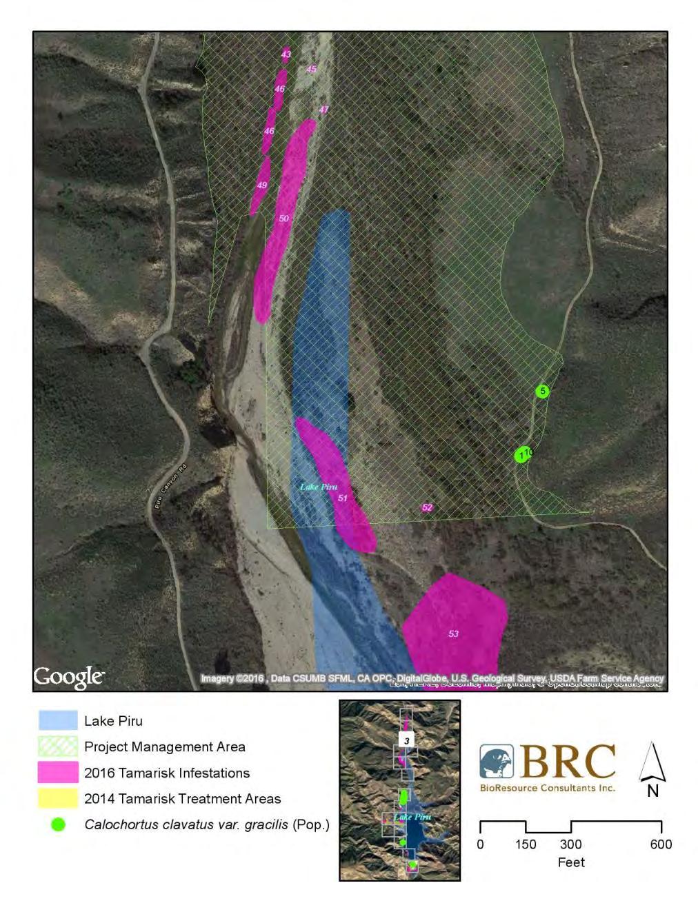
20 Additional literature and databases referenced include: The Jepson Manual (Baldwin 2012) The Jepson eflora Project and Consortium of California Database (Jepson 2016) Inventory of Rare and Endangered Plants of California (CNPS 2010) 2.2 FIELD SURVEY METHODS BioResource Consultants, Inc., (BRC) botanists Steve Jones and Sarah Termondt conducted a focused survey for target noxious weed species within the Project Management Area from April 18 to 21, Surveys were conducted by walking meandering transects within portions of the Project Management Area that are accessible by foot. Transects were spaced to allow for maximal visual coverage of the Project Management Area while taking into account topography and vegetation density. Handheld GPS units were utilized to record occurrences of target invasive/noxious species in the field and to assess the status of previously mapped infested and/or treated areas. Population densities and representative photos for noxious weed and incidental special-status plant population occurrences were taken. Plant species were identified in the field or collected for subsequent identification using keys in Baldwin (2012). Nomenclature generally follows Sawyer et al. (2009) for vegetation types and communities, Calflora (2016), Baldwin (2012), and current scientific data (e.g., scientific journals) for individual plant species. Individuals or populations of incidental special-status plant species were keyed out and recorded while in the field. All wildlife species observed within the Project Management Area during the 2016 survey were recorded based on sight, call, tracks, nests, scat, remains, or other distinguishing sign. Binoculars (10x40) were utilized to identify wildlife species. Wildlife taxonomy follows Stebbins (2012) for amphibians and reptiles, Sibley (2000) for birds, and Jameson and Peeters (2004) for mammals. 3.0 RESULTS A total of 157 plant species were identified during surveys, including 39 non-native species and one incidental special-status species with California Rare Plant Rankings (CRPR) of 1B.2 (Appendix C). Of the 39 non-native species identified during the survey, only tamarisk is a target noxious weed TARGET NOXIOUS WEED POPULATIONS Seventy-nine populations of tamarisk, a target noxious weed, were identified during the 2016 survey within the Project Management Area. Within these populations, an estimated total of 4,697 tamarisk individuals covering 12.2 acres with an average canopy cover of 28 percent was documented (Appendix B). Aerial mapping with detailed delineated polygon areas representing the 2016 extent of tamarisk infestations within the Project Management Area, as well as previous treatment areas, is presented in Appendix A. A corresponding table with characterizations of each polygon encountered in 2016 based on acreage, quantity of plants observed, and percent coverage of tamarisk is presented in Appendix B. Representative photos are provided in Appendix D. Incidental tamarisk observations made outside of the Project Management Area during the 2016 survey indicate that tamarisk recruitment is increasing in newly exposed areas of Lake Piru as the wetted perimeter recedes. Tamarisk infestations were noted to be prominent in these transitional
21 areas between the wetted perimeter of the lake and the high water mark. These transitional areas lie adjacent to and outside of the designated Project Management Area Tamarisk Tamarisk, also known as salt cedar, is a shrub or a tree native to Europe and Asia in the family Tamariaceae. It is generally found along streams and lake shores throughout California and most of the southwestern United States. It is associated with dramatic changes in geomorphology, groundwater availability, soil chemistry, fire frequency, plant community composition, and native wildlife diversity (Cal-IPC 2016). Tamarisk is rated as High on the Cal-IPC inventory indicating the species has severe ecological impacts on physical processes, plant and animal communities, and vegetation structure. Its reproductive biology and other attributes are conducive to moderate to high rates of dispersal and establishment. Mature tamarisk plants have extensive root systems and are able to reproduce vegetatively by adventitious roots or by seed. Each plant can produce as many as 500,000 seeds annually. Tamarisk can produce seed throughout the growing season. Environmental factors, including fire, drought, and herbicide, which induce high stress, can increase flowering and seed production. Seeds are small with a small tuft of hair attached to one end which facilitate wind and water dispersal. They can germinate within 24 hours after dispersal, sometimes while still floating on the water (Zouhar 2003). Seeds produced during the summer do not form a persistent seed bank, remaining viable for 24 to 45 days. Winter longevity under ideal conditions is approximately 130 days. Seed mortality is generally due to desiccation. If seeds are not germinated during the summer that they are dispersed, almost none germinate the following spring (Zouhar 2003). 3.2 SPECIAL-STATUS PLANT SPECIES One special-status plant species, slender mariposa lily (Calochortus clavatus var. gracilis) was observed during the 2016 noxious weed survey. Population locations within the Project Management Area are presented in Appendix A. Representative photos are provided in Appendix D. A species description is found below Slender mariposa lily Listing: CNPS 1B.2 Slender mariposa lily is a perennial herb (bulb) that is native to California. It is generally encountered within chaparral habitat on shaded hillsides of canyons at elevations below 1,000 meters. This species generally blooms from May to June. The California Native Plant Society designates the slender mariposa lily with CRPR of 1B.2. Plants with a rank of 1B.2 are considered rare throughout their range with 20-80% of known occurrences moderately threatened (CNPS 2010). Most of the plants that are ranked 1B have declined significantly over the last century. All plants constituting CRPR of 1B meet the definitions of the California Endangered Species Act of the California Department of Fish and Game Code and are eligible for state listing. Impacts to these species or their habitat must be analyzed during preparation of environmental documents relating to CEQA, or those considered to be functionally equivalent to CEQA, as they meet the definition of Rare or Endangered under CEQA Guidelines 15125; (c) and/or (CNPS 2010).
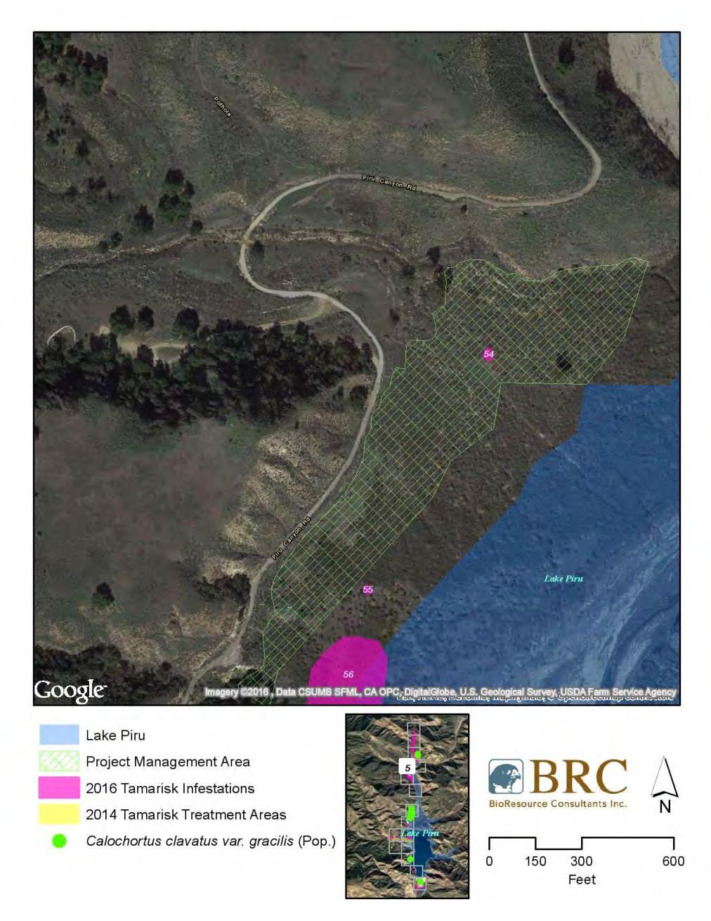
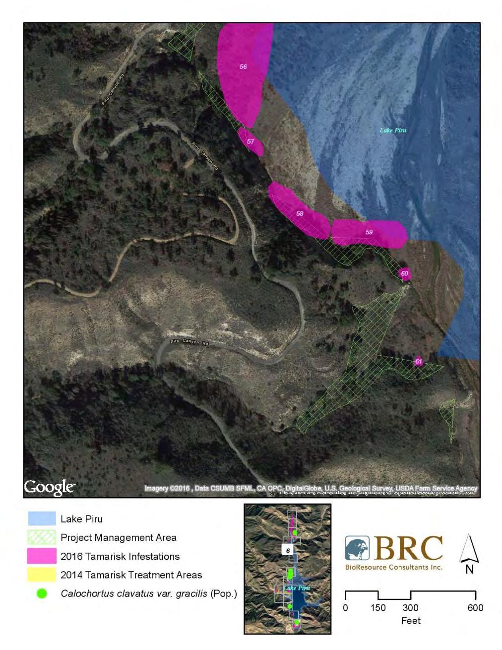
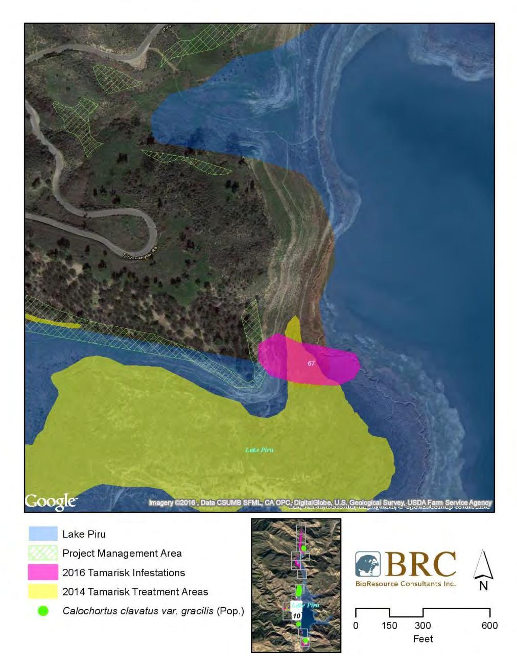
22 Sixteen locations of slender mariposa lily were incidentally observed during the 2016 noxious weed survey. Approximately 153 individuals were observed to be in full bloom at the time of the surveys, primarily encountered on moderately sloped hills north of the Juan Fernandez Boat Launch Area (Appendixes A and D). 4.0 DISCUSSION One target weed species, tamarisk, was observed during the 2016 noxious weed survey. Within 79 tamarisk populations observed, an estimated total 4,697 tamarisk individuals covering12.2 acres with an average of 28 percent canopy cover was documented (Appendix B). The 2016 noxious weed survey identified that the area of greatest tamarisk infestation within the Project Management Area occurs over a mile-long segment south of Blue Point Campground that runs along Piru Creek within Polygons 3-51 (Appendix A, Sheets 1-3). This area is also designated as critical habitat for endangered arroyo toad (Anaxyrus californicus), endangered southwestern willow flycatcher (Empidonax traillii extimus), and threatened California red-legged frog (Rana draytonii) and has not been treated in the past as a result of LPNF consultation to exclude these areas (United 2015). An additional area of notable infestation within the Project Management Area is the northwestern edge of Piru Lake where Polygons are located (Appendix A, Sheets 5-6). Multiple new tamarisk populations were also observed within the previous treatment areas, specifically the Reasoner Canyon area within Polygons 63-67(Appendix A, Sheet 10-11). New growth in previously treated areas is not as dense as new growth surrounding the wetted perimeter of the lake. Lack of success for control treatments on previous tamarisk plants with smaller stalk diameters is likely attributed to the limited surface area for herbicide uptake following treatment. In consensus with observations presented during 2014 and 2015 annual reporting (United 2015), observations made during the 2016 survey indicate that tamarisk recruitment is increasing in newly exposed areas as the wetted perimeter of Lake Piru recedes in response to continued drought conditions (NCDC 2016). Tamarisk infestations were noted to be prominent in these transitional areas between the wetted perimeter of the lake and the high water mark. These transitional areas lie adjacent to and outside of the designated Project Management Area. One special-status plant species, slender mariposa lily, was also incidentally observed during the 2016 survey. Weed removal activities may impact individuals or local populations of this species. Slender mariposa lily was documented to occur on hillsides west and east of tamarisk populations. These areas are avoidable but may be utilized to access the Project Management Area (Appendix A).
23 5.0 REFERENCES Baldwin, B.G. et al. [eds.] The Jepson Manual: Vascular Plants of California: Second Edition. University of California Press. Berkeley and Los Angeles, CA. CalFlora The CalFlora Database: information on California plants for education, research and conservation [web application]. The CalFlora Database, Berkeley, California. Accessed May California Natural Diversity Database (CNDDB) Rarefind 5 [Internet]. California Department of Fish and Wildlife [v5]. California Department of Food and Agriculture (CDFA) Weed Ratings. Plant health and Pest Prevention Services. March. California Department of Fish and Wildlife (CDFW) Biogeographic Information and Observation System (BIOS). Available online: Accessed June, CDFW CWHR version 8.1 personal computer program. California Interagency Task Group, California Department of Fish and Game, Sacramento, CA. California Native Plant Society (CNPS) Inventory of Rare and Endangered Plants of California (seventh edition, online version 7-010d). California Native Plant Society, Sacramento, CA. Accessed May, CNPS The California Rare Plant Ranking System. California Native Plant Society. Sacramento. Accessed June, 2016 CalWeedMapper Weed Mapper. California Invasive Plant Council, Berkeley, CA. Accessed May Cal-IPC California Invasive Plant Inventory. Invasive plant management -Plant profiles; Tamarix ramosissima. California Invasive Plant Council: Berkeley, CA. Accessed May Jepson Flora Project (eds.) The Jepson eflora Project and Consortium of California Database. Accessed May National Climatic Data Center (NCDC) Drought Severity Index by Division for June 25, National Oceanic and Atmospheric Administration, Asheville, NC. Accessed June Peeters H. J.; Jameson, E. W., Jr.; (2004). Mammals of California. Berkeley: University of California Press. Sawyer, J., T. Keeler-Wolf, and J. Evens A Manual of California Vegetation, Second Edition. California Native Plant Society. Sacramento, CA. Sibley, D.A National Audubon Society The Sibley Guide to Birds. Alfred A. Knopf, Inc.; New York, NY. Stebbins, R C., and SM McGinnis Field Guide to Amphibians and Reptiles of California: Revised Edition (California Natural History Guides) University of California Press.
24 USDA Forest Service (USDA-FS) Species Accounts Plants. Southern California Forest Plan Revisions, Final Publications. United Water Conservation District (United) Report on Botanical Resources; Section 3.3. Santa Felicia Relicensing Project FERC Project No United Santa Felicia Project Vegetation and Noxious Weed Management Plan. FERC Project No September. United Annual Vegetation and Noxious Weed Management Report, Santa Felicia Project; 2015 Reporting Period. Environmental Planning and Conservation Department. December 31, Zouhar, Kris Tamarisk spp. In: Fire Effects Information System, [Online]. U.S. Department of Agriculture, Forest Service, Rocky Mountain Research Station, Fire Sciences Laboratory (Producer). Available: Accessed June, 2016.
25 APPENDIX A: PROJECT MANAGEMENT AREA WITH WEED INFESTATION AND SPECIAL-STATUS PLANT LOCATIONS

26

27

28
29

30
31
32

33

34

35
36

37

38

39

40

41

42
43 APPENDIX B: TABLE OF 2016 TAMARISK OCCURRENCE DETAILS
44 Sheet Number Polygon ID Latitude Longitude Acreage Percent Canopy Cover Population Count
45 ** **
46 **
47 TOTALS * 4697 *Average percent canopy cover across project management area. **Not mapped; outside of survey area.
48 APPENDIX C: FLORA AND FAUNA OBSERVED DURING 2016 SURVEY
49 Table 1. Plant Species Observed During the 2016 Survey. Scientific Name Common Name Family Native/Non-Native PLANTS Achillea millefolium yarrow Asteraceae Native Acmispon glaber deerweed Fabaceae Native Acmispon strigosus strigose lotus Fabaceae Native Acourtia microcephala sacapellote Asteraceae Native Adenostoma fasciculatum chamise Rosaceae Native Alnus rhombifolia white alder Betulaceae Native Ambrosia psilostachya ragweed Asteraceae Native Amsinckia intermedia common fiddleneck Boraginaceae Native Anagallis arvensis scarlet pimpernell Myrsinaceae Non-native Apiastrum angustifolium wild celery Apiaceae Native Arctostaphylos glauca big berry manzanita Ericaceae Native Artemisia californica coastal sage brush Asteraceae Native Artemisia douglasiana mugwort Asteraceae Native Asclepias fascicularis narrow leaf milkweed Apocynaceae Native Atriplex lentiformis quailbush Chenopodiaceae Native Atriplex semibaccata Australian saltbush Chenopodiaceae Non-native Avena barbata wild oats Poaceae Non-native Baccharis pilularis coyote bush Asteraceae Native Baccharis salicifolia mulefat Asteraceae Native Bloomeria crocea golden stars Liliaceae Native Brassica nigra black mustard Brassicaceae Non-native Brickellia californica California brickellia Asteraceae Native Bromus diandrus ripgut brome Poaceae Native Bromus hordeaceus soft chess Poaceae Non-native Bromus rubens foxtail chess Poaceae Non-native Calandrinia menziesii red maids Montiaceae Native Calochortus clavatus var. gracilis* slender mariposa lily Liliaceae Native Calystegia peirsonii Peirson's morning glory Convolvulaceae Native Cammissonia bistorta California sun cup Onagraceae Native Capsella bursa-pastoris shepard's purse Brassicaceae Non-native Castilleja exserta purple owl's clover Orobanchaceae Native Castilleja foliolosa Texas paintbrush Orobanchaceae Native Ceanothus crassifolius hoary-leaved ceanothus Rhamnaceae Native Centaurea mellitensis tocalote Asteraceae Non-native Chaenactis glabriuscula yellow pincushion Asteraceae Native Chenopodium album lamb's quarters Chenopodiaceae Non-native Cirsium occidentale cobweb thistle Asteraceae Native
50 Clarkia purpurea ssp. quadrivulnera purple clarkia Onagraceae Native Clarkia unguiculata woodland clarkia Onagraceae Native Claytonia perfoliata miners lettuce Montiaceae Native Collinsia heterophylla Chinese houses Plantaginaceae Native Conium maculatum Poison hemlock Apiaceae Non-native Convolvulus arvensis bindweed Convolvulaceae Non-native Corethrogyne filaginifolia common sandaster Asteraceae Native Croton setiger turkey-mullein Euphorbiaceae Native Croton setigerus dove weed Euphorbiaceae Native Cryptantha intermedia common cryptantha Boraginaceae Native Cryptantha sp. popcorn flower Boraginaceae Native Cucurbita foetidissima Missouri gourd Cucurbitaceae Native Cynodon dactylon Bermuda grass Poaceae Non-native Datura wrightii Jimson's weed Solanaceae Native Deinandra fasciculata clustered tarweed Asteraceae Native Delphinium sp. larkspur Ranunculaceae Native Dichelostemma capitatum blue dicks Themidaceae Native Distichlis spicata saltgrass Poaceae Native Emmenanthe penduliflora whispering bells Boraginaceae Native Encelia californica bush sunflower Asteraceae Native Epilobium canum ssp. canum California fuchsia Onagraceae Native Eriodictyon crassifolium thick-leaved yerba santa Boraginaceae Native Eriogonum fasciculatum California buckwheat Polygonaceae Native Eriophyllum confertiflorum golden yarrow Asteraceae Native Erodium cicutarium red stemmed filaree Geraniaceae Non-native Eschscholzia californica California poppy Papaveraceae Native Eucrypta chrysanthemifolia spotted eucrypta Boraginaceae Native Euphorbia albomarginata rattlesnake weed Euphorbiaceae Native Festuca microstachys small fescue Poaceae Non-native Ficus carica common fig Moraceae Non-native Foeniculum vulgare fennel Apiaceae Non-native Fraxinus dipetala two petaled ash Oleaceae Native Galium angustifolium narrow leaved bedstraw Rubiaceae Native Gilia sp. gilia Polemoniaceae Native Hazardia squarrosa sawtooth goldenbush Asteraceae Native Heliotropium curassavicum Chinese parsley Boraginaceae Native Helminthotheca echoides bristly ox tongue Asteraceae Non-native Hesperoyucca whipplei chaparral yucca Agavaceae Native Heteromeles arbutifolia toyon Rosaceae Native Heterotheca grandiflora telegraph weed Asteraceae Native Hirschfeldia incana summer mustard Brassicaceae Non-native Hordeum murinum foxtail barley Poaceae Native
51 Juglans californica California black walnut Juglandaceae Native Keckiella cordifolia heart leaved keckiella Plantaginaceae Native Lactuca serriola prickly lettuce Asteraceae Non-native Lepidium nitidum shining pepper grass Brassicaceae Native Lepidospartum squamatum scalebroom Asteraceae Native Leymus condensatus giant wild rye Poaceae Native Linanthus californicus prickly phlox Polemoniaceae Native Lupinus microcarpus var. densiflorus chick lupine Fabaceae Native Lysimachia arvensis scarlet pimpernel Myrsinaceae Non-native Malacothamnus fasciculatus chaparral bush mallow Malvaceae Native Malacothrix saxatilis cliff aster Asteraceae Native Malosma laurina laurel sumac Anacardiaceae Native Malva parviflora cheeseweed Malvaceae Non-native Marah macrocarpa chilicothe Cucurbitaceae Native Marrubium vulgare white horehound Lamiaceae Non-native Matricaria discoidea pineapple weed Asteraceae Native Medicago polymorpha California burclover Fabaceae Non-native Melica imperfecta small flowered melica Poaceae Native Melilotus albus white sweet clover Fabaceae Non-native Melilotus officinalis yellow sweet clover Fabaceae Non-native Mentzelia micrantha small flowered stickleaf Loasaceae Native Mimulus aurantiacus sticky monkeyflower Phrymaceae Native Nassella pulchra purple needle grass Poaceae Native Nasturtium officinale watercress Brassicaceae Native Nerium oleander oleander Apocynaceae Non-native Nicotiana glauca tree tobacco Solanaceae Non-native Opuntia basilaris var. basilaris beavertail cactus Cactaceae Native Orobanche sp. broomrape Orobanchaceae Native Pectocarya linearis sagebrush combseed Boraginaceae Native Peritoma arborea bladderpod Cleomaceae Native Phacelia distans common phacelia Boraginaceae Native Phacelia tanacetifolia fern-leaf phacelia Boraginaceae Native Phacelia viscida sticky phacelia Boraginaceae Native Plagiobothrys sp. popcorn flower Boraginaceae Native Plantago erecta California plantain Plantaginaceae Native Plantago major common plantain Plantaginaceae Non-native Platanus racemosa California sycamore Plantaceae Native Polygonum aviculare knotweed Polygonaceae Non-native Populus fremontii Fremont's cottonwood Salicaceae Native Pseudognaphalium biolettii two tone everlasting Asteraceae Native Pseudognaphalium californicum ladies' tobacco Asteraceae Native
52 Quercus agrifolia coast live oak Fagaceae Native Quercus lobata valley oak Fagaceae Native Rafinesquia californica chickory Asteraceae Native Rhus ovata sugar bush Anacardiaceae Native Ribes malvaceum chaparral currant Grossulariaceae Native Rubus ursinus California blackberry Rosaceae Native Rumex crispus curly dock Polygonaceae Non-native Salix exigua narrowleaf willow Salicaceae Native Salix laevigata red willow Saliaceae Native Salix lasiolepis arroyo willow Saliaceae Native Salsola tragus Russian thistle Chenopodiaceae Non-native Salvia apiana white sage Lamiaceae Native Salvia columbariae chia sage Lamiaceae Native Salvia leucophylla purple sage Lamiaceae Native Salvia mellifera black sage Lamiaceae Native Sambucus nigra ssp. caerulea blue elderberry Adoxaceae Native Sanicula crassicaulis Pacific sanicle Apiaceae Native Schinus molle Peruvian pepper tree Anacardiaceae Non-native Silybum marianum milk thistle Asteraceae Non-native Sisymbrium irio London rocket Brassicaceae Non-native Sisyrinchium bellum blue eyed grass Iridaceae Native Solanum sp. nightshade Solanaceae Native Solanum xanti Xanti's nightshade Solanaceae Native Sonchus sasper sow thistle Asteraceae Non-native Stachys albens white hedge nettle Lamiaceae Native Stephanomeria virgata twiggy wreath plant Asteraceae Native Stillingia linearifolia narrow leaved stillingia Euphorbiaceae Native Tamarisk ramosisima tamarisk Tamaricaceae Non-native Taraxacum officinale dandelion Asteraceae Non-native Toxicodendron diversilobum poison oak Anacardiaceae Native Tribulus terrestris puncture vine Zygophyllaceae Non-native Typha sp. cattail Typhaceae Native Uropappus lindleyi silver puffs Asteraceae Native Urtica dioica stinging nettle Urticaceae Native Verbena lasiostachys western vervain Verbenaceae Native Vicia villosa smooth vetch Fabaceae Non-native Zeltnera venusta charming centaury Gentianaceae Native
53 Table 2. Wildlife Species Observed During the 2016 Survey. Scientific Name BIRDS Aechmophorus occidentalis Aeronautes saxatalis Agelaius phoeniceus Anas cyanoptera Anas platyrhynchos Aphelocoma californica Ardea alba Ardea herodias Buteo jamaicensis Callipepla californica Calypte anna Calypte costae Cardellina pusilla Cathartes aura Catherpes mexicanus Colaptes auratus Corvus corax Falco sparverius Fulica americana Geothlypis trichas Haemorhous mexicanus Haliaeetus leucocephalus Hirundinidae sp. Hydroprogne caspia Icterus bullockii Megaceryle alcyon Melanerpes formicivorus Melanerpes lewis Melospiza melodia Melozone crissalis Mergus merganser Mimus polyglottos Myiarchus cinerascens Nycticorax nycticorax Oxyura jamaicensis Passer domesticus Passerina amoena Petrochelidon pyrrhonota Common Name Western Grebe White-throated Swift Red-winged Blackbird Cinnamon Teal Mallard Western Scrub-Jay Great Egret Great Blue Heron Red-tailed Hawk California Quail Anna's Hummingbird Costa's Hummingbird Wilson's Warbler Turkey Vulture Canyon Wren Northern Flicker Common Raven American Kestrel American Coot Common Yellowthroat House Finch Bald Eagle swallow sp. Caspian Tern Bullock's Oriole Belted Kingfisher Acorn Woodpecker Lewis's Woodpecker Song Sparrow California Towhee Common Merganser Northern Mockingbird Ash-throated Flycatcher Black-crowned Night-Heron Ruddy Duck House Sparrow Lazuli Bunting Cliff Swallow
54 Scientific Name Phainopepla nitens Phalacrocorax auritus Pheucticus melanocephalus Picoides nuttallii Pipilo maculatus Podiceps nigricollis Podilymbus podiceps Psaltriparus minimus Quiscalus mexicanus Salpinctes obsoletus Sayornis nigricans Sialia mexicana Spinus lawrencei Spinus psaltria Sturnus vulgaris Troglodytes aedon Turdus migratorius Tyrannus verticalis Vireo bellii Zenaida macroura MAMMALS Canis latrans Otospermophilus beecheyi REPTILES Aspidoscelis tigris stejnegeri Phrynosoma blainvillii Pituophis catenifer Sceloporus occidentalis Uta stansburiana Common Name Phainopepla Double-crested Cormorant Black-headed Grosbeak Nuttall's Woodpecker Spotted Towhee Eared Grebe Pied-billed Grebe Bushtit Great-tailed Grackle Rock Wren Black Phoebe Western Bluebird Lawrence's Goldfinch Lesser Goldfinch European Starling House Wren American Robin Western Kingbird Bell's Vireo Mourning Dove coyote California ground squirrel San Diego tiger whiptail coast horned lizard gopher snake western fence lizard side-blotched lizard
55 APPENDIX D: PHOTOS

56 Photo 1. Reasoner Canyon previous treatment area with new tamarisk populations. Transitional area populations also visible. Photo facing southeast.

57 Photo 2. Mile long segment of tamarisk infestation just south of Blue Point Campground in the northernmost portion of the Project Management Area. Photo facing north.

58 Photo 3. Close-up of tamarisk infestation south of Blue Point Campground along Piru Creek in the northernmost portion of the Project Management Area. Photo facing southwest.

59 Photo 4. Close-up of tamarisk infestation south of Blue Point Campground along Piru Creek in the northernmost portion of the Project Management Area. Photo facing south.

60 Photo 5. Close-up of tamarisk infestation south of Blue Point Campground along Piru Creek in the northernmost portion of the Project Management Area. Photo facing west.

61 Photo 6. Slender mariposa lily population observed within the northern portion of the Project Management Area. Photo facing east.
15 Non-Native Plants at Lake Mead National Recreation Area
 15 Non-Native Plants at Lake Mead National Recreation Area To report weed locations use non-native plant survey form and/or contact: Carrie Norman Exotic Plant Manager carrie_norman@nps.gov 702-293-8734
Appendix J Vegetation Change Analysis Methodology
 Appendix J Vegetation Change Analysis Methodology Regional Groundwater Storage and Recovery Project Draft EIR Appendix-J April 2013 APPENDIX J- LAKE MERCED VEGETATION CHANGE ANALYSIS METHODOLOGY Building
Second Annual Monitoring Report Tidal Wetland Restoration 159 Long Neck Point Road, Darien, CT NAE
 1) Project Overview Second Annual Monitoring Report Tidal Wetland Restoration 159 Long Neck Point Road, Darien, CT NAE-2007-1130 December 13, 2013 This is the second year of a five year monitoring program
Mapping for Successful Management. Kayla Malone Chaffee County Noxious Weed Department Supervisor
 Mapping for Successful Management Kayla Malone Chaffee County Noxious Weed Department Supervisor Outline Mapping and CDA guidelines EDDMapS Point, line, or polygon? Plant life cycles Examples of implementation
Third Annual Monitoring Report Tidal Wetland Restoration 159 Long Neck Point Road, Darien, CT NAE
 1) Project Overview Third Annual Monitoring Report Tidal Wetland Restoration 159 Long Neck Point Road, Darien, CT NAE-2007-1130 December 15, 2014 This is the third year of a five year monitoring program
Native Species? In US prior to European settlement
 INVASIVE SPECIES Native Species? An organism that is a part of the balance of nature that has developed over hundreds or thousands of years in a particular region or ecosystem. In US prior to European
SAN FRANCISCO DISTRICT INFORMATION REQUESTED FOR VERIFICATION OF CORPS JURISDICTION
 DEPARTMENT OF THE ARMY SAN FRANCISCO DISTRICT, U.S. ARMY CORPS OF ENGINEERS 1455 MARKET STREET SAN FRANCISCO, CALIFORNIA 94103-1398 SAN FRANCISCO DISTRICT INFORMATION REQUESTED FOR VERIFICATION OF CORPS
Grant Opportunity Monitoring Bi-State Sage-grouse Populations in Nevada
 Grant Opportunity Monitoring Bi-State Sage-grouse Populations in Nevada Proposals are due no later than November 13, 2015. Grant proposal and any questions should be directed to: Shawn Espinosa @ sepsinosa@ndow.org.
1. PURPOSE 2. PERIOD OF PERFORMANCE
 Statement of Work Herbarium Voucher Collection Land Management Section, Environmental Security Department Marine Corps Installations West Marine Corps Base Camp Pendleton, California 1. PURPOSE The purpose
WEED WATCH LEEANNE MILA EL DORADO COUNTY DEPARTMENT OF AGRICULTURE
 WEED WATCH LEEANNE MILA EL DORADO COUNTY DEPARTMENT OF AGRICULTURE YELLOW STARTHISTLE WHY DO WE CARE ABOUT INVASIVE WEEDS? HIGHLY AGGRESSIVE DISPLACE NATIVES AND DESIRABLE PLANTS DECREASE WILDLIFE HABITAT
1.0 PURPOSE AND FORMAT OF THE FINAL EIR
 1.0 PURPOSE AND FORMAT OF THE FINAL EIR 1.1 PROJECT OVERVIEW CEMEX (RMC Pacific Materials, dba CEMEX) operates the Bonny Doon Shale and Limestone Quarries in Santa Cruz County for the production of Portland
leeanne mila El dorado county department agriculture
 leeanne mila El dorado county department Of agriculture } highly aggressive displace natives and desirable plants } decrease wildlife habitat forming monocultures } Reduce recreational values and uses
U.S. ARMY CORPS OF ENGINEERS
 CORPS FACTS Regulating Mississippi River Navigation Pools U.S. ARMY CORPS OF ENGINEERS BUILDING STRONG Historical Background Federal improvements in the interest of navigation on the Mississippi River
FINAL AESTHETICS RESOURCES STUDY PLAN. Takatz Lake Hydroelectric Project, FERC No Prepared by: City and Borough of Sitka Electric Department
 FINAL AESTHETICS RESOURCES STUDY PLAN Takatz Lake Hydroelectric Project, FERC No. 13234 Prepared by: City and Borough of Sitka Electric Department 105 Jarvis St., Sitka AK, 99835 INTRODUCTION and BACKGROUND
17-20 November 2007 Incidental Take Monitoring Methodology and Results
 Sample Site Selection Protocol 17-20 November 2007 Incidental Take Monitoring Methodology and Results On 16 November 2007, the U.S. Fish and Wildlife Service (USFWS) provided the USACE Mobile District
Survey & Manage Compliance Report Pettijohn LSR Project Tom Quinn April 13, 2011 Updated and Edited by Kelly Wolcott May 4, 2011.
 Survey & Manage Compliance Report Pettijohn LSR Project Tom Quinn April 13, 2011 Updated and Edited by Kelly Wolcott May 4, 2011. The Pettijohn LSR Project is consistent with the Settlement Agreement finalized
UPPER COSUMNES RIVER FLOOD MAPPING
 UPPER COSUMNES RIVER FLOOD MAPPING DRAFT BASIC DATA NARRATIVE FLOOD INSURANCE STUDY SACRAMENTO COUTY, CALIFORNIA Community No. 060262 November 2008 Prepared By: CIVIL ENGINEERING SOLUTIONS, INC. 1325 Howe
PRELIMINARY DRAFT FOR DISCUSSION PURPOSES
 Memorandum To: David Thompson From: John Haapala CC: Dan McDonald Bob Montgomery Date: February 24, 2003 File #: 1003551 Re: Lake Wenatchee Historic Water Levels, Operation Model, and Flood Operation This
1:30 2:00 Tangible Examples of NVC Uses from Monitoring, Mapping, and Habitat Modeling. (Todd Keeler- Wolf, ESA Panel)
") 1:30 2:00 Tangible Examples of NVC Uses from Monitoring, Mapping, and Habitat Modeling. (Todd Keeler- Wolf, ESA Panel) Habitat Modeling for Mojave Ground Squirrel: a rare species of the Western Mojave
1:30 2:00 Tangible Examples of NVC Uses from Monitoring, Mapping, and Habitat Modeling. (Todd Keeler- Wolf, ESA Panel) Habitat Modeling for Mojave Ground Squirrel: a rare species of the Western Mojave
The following maps must be provided as a part of the ADA. The appropriate scale for each map should be determined at the pre application conference.
 Main Street @ Coconut Creek DRI QUESTION 9 MAPS The following maps must be provided as a part of the ADA. The appropriate scale for each map should be determined at the pre application conference. Map
Wisconsin s Invasive Species Classification Assessment and Rule
 Wisconsin s Invasive Species Classification Assessment and Rule The Process Legislature gave WIDNR authority to create an invasive species classification system. Legislature also created Wis. Council on
NORTHUMBERLAND COUNTY, PA
 QUAKER RUN Stream and Wetland Restoration As-Built Completion Report and First Year Monitoring Data Coal Township NORTHUMBERLAND COUNTY, PA Upstream Before Upstream After Prepared for: COAL TOWNSHIP 805
PENNSYLVANIA DEPARTMENT OF TRANSPORTATION ENGINEERING DISTRICT 3-0
 PENNSYLVANIA DEPARTMENT OF TRANSPORTATION ENGINEERING DISTRICT 3-0 LYCOMING COUNTY S.R.15, SECTION C41 FINAL HYDROLOGIC AND HYDRAULIC REPORT STEAM VALLEY RUN STREAM RELOCATION DATE: June, 2006 REVISED:
Natural Resource Management. Northern Tasmania. Strategy. Appendix 2
 Natural Resource Management Strategy Northern Tasmania 2015 2020 Appendix 2 Appendix 2 Appendix 2. Carbon Planting Spatial Prioritisation In support of this Strategy s development and implementation, work
TSEGI WASH 50% DESIGN REPORT
 TSEGI WASH 50% DESIGN REPORT 2/28/2014 Daniel Larson, Leticia Delgado, Jessica Carnes I Table of Contents Acknowledgements... IV 1.0 Project Description... 1 1.1 Purpose... 1 Figure 1. Erosion of a Headcut...
5.2. IDENTIFICATION OF NATURAL HAZARDS OF CONCERN
 5.2. IDENTIFICATION OF NATURAL HAZARDS OF CONCERN To provide a strong foundation for mitigation strategies considered in Sections 6 and 9, County considered a full range of natural hazards that could impact
GROUND DISTURBANCE AND REVEGETATION GUIDELINES
 GROUND DISTURBANCE AND REVEGETATION GUIDELINES Ravalli County Weed District 329 Airport Road Stevensville, Montana 59870 406-777-5842 kmorris@rc.mt.gov To comply with the MONTANA S COUNTY WEED CONTROL
Illinois Drought Update, December 1, 2005 DROUGHT RESPONSE TASK FORCE Illinois State Water Survey, Department of Natural Resources
 Illinois Drought Update, December 1, 2005 DROUGHT RESPONSE TASK FORCE Illinois State Water Survey, Department of Natural Resources For more drought information please go to http://www.sws.uiuc.edu/. SUMMARY.
Southwest LRT Habitat Analysis. May 2016 Southwest LRT Project Technical Report
 Southwest LRT Habitat Analysis Southwest LRT Project Technical Report This page intentionally blank. Executive Summary This technical report describes the habitat analysis that was performed to support
One of the many strengths of a GIS is that you can stack several data layers on top of each other for visualization or analysis. For example, if you
 One of the many strengths of a GIS is that you can stack several data layers on top of each other for visualization or analysis. For example, if you overlay a map of the habitat for an endangered species
Vegetation and Wildlife Habitat Mapping Study in the Upper and Middle Susitna Basin Study Plan Section 11.5
 (FERC No. 14241) Vegetation and Wildlife Habitat Mapping Study in the Upper and Middle Susitna Basin Study Plan Section 11.5 Initial Study Report Part C: Executive Summary and Section 7 Prepared for Prepared
The Invasion of False Brome in Western Oregon
 The Invasion of False Brome in Western Oregon GIS II Presentation Winter 2006 Will Fellers Kurt Hellerman Kathy Strope Statia Cupit False Brome (Brachypodium sylvaticum) Perennial bunchgrass native to
Big Chino Valley Pumped Storage Project (FERC No ) Vegetation Mapping and Habitat Assessment Study Plan
 Vegetation Mapping and Habitat Assessment Study Plan") March 21, 2018 1.0 Introduction Big Chino Valley Pumped Storage LLC (BCV), a subsidiary of ITC Holdings Corp. (ITC), submitted a preliminary permit application to the Federal Energy Regulatory Commission
March 21, 2018 1.0 Introduction Big Chino Valley Pumped Storage LLC (BCV), a subsidiary of ITC Holdings Corp. (ITC), submitted a preliminary permit application to the Federal Energy Regulatory Commission
3.0 TECHNICAL FEASIBILITY
 3.0 TECHNICAL FEASIBILITY 3.1 INTRODUCTION To enable seasonal storage and release of water from Lake Wenatchee, an impoundment structure would need to be constructed on the lake outlet channel. The structure
Climate Change and Invasive Plants in the Pacific Northwest
 Climate Change and Invasive Plants in the Pacific Northwest David W Peterson Becky K Kerns Ecosystem Dynamics and Environmental Change Team Threat Characterization and Management Program Pacific Northwest
The original tiered SAV distribution restoration targets
 CHAPTER VIII Chesapeake Bay SAV Distribution Restoration Goals and Targets The original tiered SAV distribution restoration targets for Chesapeake Bay were first published in the 1992 SAV technical synthesis
5.2 IDENTIFICATION OF HAZARDS OF CONCERN
 5.2 IDENTIFICATION OF HAZARDS OF CONCERN 2015 HMP Update Changes The 2010 HMP hazard identification was presented in Section 6. For the 2015 HMP update, the hazard identification is presented in subsection
President s Day Weekend Storm Community Meeting and Workshop April 17, 2017
 President s Day Weekend Storm Community Meeting and Workshop April 17, 2017 Meeting outline 1. Progress update on the City of San Jose s recovery efforts 2. Water district presentation on: Weather situation
NEWS RELEASE UNDER SECTION 404 OF THE CLEAN WATER ACT (33 USC 1344) ACTION NUMBER SPA ABQ
 ACTION NUMBER SPA ABQ") PUBLIC NOTICE Public Notice Issue Date: //6/07 Albuquerque District Comments due: /6/08 NEWS RELEASE UNDER SECTION 0 OF THE CLEAN WATER ACT ( USC ) ACTION NUMBER SPA-06-00-ABQ BANK STABILIZATION ALONG
PUBLIC NOTICE Public Notice Issue Date: //6/07 Albuquerque District Comments due: /6/08 NEWS RELEASE UNDER SECTION 0 OF THE CLEAN WATER ACT ( USC ) ACTION NUMBER SPA-06-00-ABQ BANK STABILIZATION ALONG
9. PROBABLE MAXIMUM PRECIPITATION AND PROBABLE MAXIMUM FLOOD
 9. PROBABLE MAXIMUM PRECIPITATION AND PROBABLE MAXIMUM FLOOD 9.1. Introduction Due to the size of Watana Dam and the economic importance of the Project to the Railbelt, the Probable Maximum Flood (PMF)
Weed Identification and Control. Jim Wanstall NMDA State Noxious Weed Coordinator
 Weed Identification and Control Jim Wanstall NMDA State Noxious Weed Coordinator What Is A Weed? A weed is any plant that interferes with the management objectives for a particular site. An invasive weed
Little Blackfoot TPA 2009 Sediment and Habitat Assessment QAQC Review March 9, 2010
 Little Blackfoot TPA 2009 Sediment and Habitat Assessment QAQC Review March 9, 2010 1.0 PROJECT OVERVIEW Sediment and habitat monitoring in the Little Blackfoot TPA was conducted in July of 2009 as outlined
VEGETATION EVA BOEHRINGER
 VEGETATION EVA BOEHRINGER April 2, 2014 WUP CONSULTATIVE COMMITTEE WUP Consultative Committee (WUP CC) recognized that riparian and wetland vegetation in the reservoir drawdown zone is valuable for fish,
Gateway Trail Project
 Gateway Trail Project Debris Flow Hazard Assessment By: Juan de la Fuente April 30, 2010 Background- On April 22, 2010, the Shasta-Trinity National Forest (Mt. Shasta-McCloud Unit) requested a geologic
Giant Salvinia Overview & History Restore America s Estuaries & The Coastal Society 2016 Summit December 15, 2016
 Giant Salvinia Overview & History Restore America s Estuaries & The Coastal Society 2016 Summit December 15, 2016 Jillian Day Aquatic Plant Control Coordinator Inland Fisheries Giant Salvinia Native to
APPENDIX E. GEOMORPHOLOGICAL MONTORING REPORT Prepared by Steve Vrooman, Keystone Restoration Ecology September 2013
 APPENDIX E GEOMORPHOLOGICAL MONTORING REPORT Prepared by Steve Vrooman, Keystone Restoration Ecology September 2 Introduction Keystone Restoration Ecology (KRE) conducted geomorphological monitoring in
EAGLES NEST AND PIASA ISLANDS
 EAGLES NEST AND PIASA ISLANDS HABITAT REHABILITATION AND ENHANCEMENT PROJECT MADISON AND JERSEY COUNTIES, ILLINOIS ENVIRONMENTAL MANAGEMENT PROGRAM ST. LOUIS DISTRICT FACT SHEET I. LOCATION The proposed
Invasive Plant Management at Joshua Tree National Park
 Invasive Plant Management at Joshua Tree National Park Neil Frakes Vegetation Branch Chief Joshua Tree National Park, Division of Science and Resource Stewardship neil_frakes@nps.gov Joshua Tree National
COUNTY OF SONOMA PERMIT AND RESOURCE MANAGEMENT DEPARTMENT 2550 Ventura Avenue, Santa Rosa, CA (707) FAX (707)
 FAX (707)") COUNTY OF SONOMA PERMIT AND RESOURCE MANAGEMENT DEPARTMENT 2550 Ventura Avenue, Santa Rosa, CA 95403 (707) 565-1900 FAX (707) 565-1103 DATE : TO: FROM: SUBJECT: July 21, 2009 at 2:30 p.m. Board of Supervisors
COUNTY OF SONOMA PERMIT AND RESOURCE MANAGEMENT DEPARTMENT 2550 Ventura Avenue, Santa Rosa, CA 95403 (707) 565-1900 FAX (707) 565-1103 DATE : TO: FROM: SUBJECT: July 21, 2009 at 2:30 p.m. Board of Supervisors
Briggs Lake Water Quality Report 2014
 Briggs Lake Water Quality Report 2014 Seasonal Report for Briggs Lake Green Oak Township, Livingston Co. T1N, R6E, Sec. 3,4 74 Surface Acres 414 Hadley Street Holly, MI 48442 Main Phone: 248-634-8388 Northern
5.2 IDENTIFICATION OF HAZARDS OF CONCERN
 5.2 IDENTIFICATION OF HAZARDS OF CONCERN 2016 HMP Update Changes The 2011 HMP hazard identification was presented in Section 3. For the 2016 HMP update, the hazard identification is presented in subsection
Use of Bioengineering Techniques for Revegetation of Riparian Areas: Colomac Mine Remediation Project, NWT
 Use of Bioengineering Techniques for Revegetation of Riparian Areas: Colomac Mine Remediation Project, NWT McPherson, M. 1, Vanderspiegel, R. 2, Breadmore, R. 2, and Hewitt, M. 3 2012 RPIC Federal Contaminated
Sustainable Groundwater Management Act: Initial Notification of a Proposed Basin Boundary Modification
 Sustainable Groundwater Management Act: Initial Notification of a Proposed Basin Boundary Modification Proposed Boundary Modification The Butte County Department of Water and Resource Conservation has
Appendix I Feasibility Study for Vernal Pool and Swale Complex Mapping
 Feasibility Study for Vernal Pool and Swale Complex Mapping This page intentionally left blank. 0 0 0 FEASIBILITY STUDY BY GIC AND SAIC FOR MAPPING VERNAL SWALE COMPLEX AND VERNAL POOLS AND THE RESOLUTION
2. PHYSICAL SETTING FINAL GROUNDWATER MANAGEMENT PLAN. 2.1 Topography. 2.2 Climate
 FINAL GROUNDWATER MANAGEMENT PLAN 2. PHYSICAL SETTING Lassen County is a topographically diverse area at the confluence of the Cascade Range, Modoc Plateau, Sierra Nevada and Basin and Range geologic provinces.
POPULATION TRENDS FOR TULARE PSEUDOBAHIA AND STRIPED ADOBE LILY
 POPULATION TRENDS FOR TULARE PSEUDOBAHIA AND STRIPED ADOBE LILY Kern County has more endangered, threatened and rare plant species than most states. The geography and environmental conditions in the county
Minimum Standards for Wetland Delineations
 Minimum Standards for Wetland Delineations Jason Gipson Chief, Utah/Nevada Regulatory Branch Sacramento District Regulatory Program Workshop 16 Mar 2016 US Army Corps of Engineers Delineation Report Minimum
Sacramento River Bank Protection Project
 2005 - FIELD RECONNAISSANCE REPORT OF BANK EROSION SITES - SACRAMENTO RIVER FLOOD CONTROL LEVEES AND TRIBUTARIES Sacramento River Bank Protection Project Project No. 32-0530.10, Task 3 Prepared for: U.S.
MEMORANDUM. Jerry Conrow, Ojai Basin Groundwater Management Agency
 MEMORANDUM TO: FROM: Jerry Conrow, Ojai Basin Groundwater Management Agency Gregory Schnaar, PhD, Stephen J. Cullen, PhD, PG, DATE: August 6, 2014, 2014 SUBJECT: Ojai Basin Groundwater Model - Extended
Distribution of Hydrilla and Giant Salvinia in Mississippi in 2005
 An Annual Report to the Mississippi Bureau of Plant Industry for 2005 John D. Madsen, Ryan M. Wersal, and Wilfredo Robles GeoResources Institute and Department of Plant and Soil Science Mississippi State
Natural Shoreline Landscapes on Michigan Inland Lakes
 Natural Shoreline Landscapes on Michigan Inland Lakes Excerpts from Chapters 2 and 3 Photo Photo by Jane by Jane Herbert Herbert Did you know? Twenty-four species of amphibians, 25 species of reptiles,
Invasive Plant Inventory & Survey Methods Web Seminar Series
 Invasive Plant Inventory & Survey Methods Web Seminar Series TODAY S PRESENTATION Landscape-Scale Wildland Inventories/Surveys: Utah State University Methods Kimberly Edvarchuk Utah State University Landscape-Scale
3.11 Floodplains Existing Conditions
 Other stormwater control practices may be needed to mitigate water quality impacts. In addition to detention facilities, other practices such as vegetated basins/buffers, infiltration basins, and bioswales
Fickeisen Plains Cactus (Pediocactus peeblesianus ssp. fickeiseniae)
") Fickeisen Plains Cactus (Pediocactus peeblesianus ssp. fickeiseniae) Monitoring Report Salt Trail Canyon Monitoring Site 2006-2008 Daniela Roth Navajo Natural Heritage Program Department of Fish & Wildlife
Fickeisen Plains Cactus (Pediocactus peeblesianus ssp. fickeiseniae) Monitoring Report Salt Trail Canyon Monitoring Site 2006-2008 Daniela Roth Navajo Natural Heritage Program Department of Fish & Wildlife
REDWOOD VALLEY SUBAREA
 Independent Science Review Panel Conceptual Model of Watershed Hydrology, Surface Water and Groundwater Interactions and Stream Ecology for the Russian River Watershed Appendices A-1 APPENDIX A A-2 REDWOOD
The Weed Battle. Sage Fitch, Salt Lake County Weed Specialist
 The Weed Battle Noxious and Invasive Weed Management by The Salt Lake County Weed Program and The Bonneville CWMA Sage Fitch, Salt Lake County Weed Specialist Our program & our partners Who are we and
J.H. Campbell Generating Facility Pond A - Location Restriction Certification Report
 J.H. Campbell Generating Facility Pond A - Location Restriction Certification Report Pursuant to: 40 CFR 257.60 40 CFR 257.61 40 CFR 257.62 40 CFR 257.63 40 CFR 257.64 Submitted to: Consumers Energy Company
Author(s): Charles K. Cover, P.E. Federal Energy Regulatory Commission
: Charles K. Cover, P.E. Federal Energy Regulatory Commission") Using GIS to Help Manage a National Energy Program Author(s): Charles K. Cover, P.E. Federal Energy Regulatory Commission The Federal Energy Regulatory Commission (FERC) has statutory oversight on key
Using GIS to Help Manage a National Energy Program Author(s): Charles K. Cover, P.E. Federal Energy Regulatory Commission The Federal Energy Regulatory Commission (FERC) has statutory oversight on key
Relatively little hard substrate occurs naturally in the
 CHAPTER FIVE Rock Habitats Relatively little hard substrate occurs naturally in the estuary, owing mainly to the vast quantities of fine sediment that have been deposited by the rivers. Rock habitat is
Orocopia Sage (Salvia greatae)
") Orocopia Sage (Salvia greatae) Legal Status Taxonomy Distribution General State: S2 1 California Rare Plant Rank: 1B.3 2 Federal: Bureau of Land Management Sensitive Critical Habitat: N/A Recovery Planning:
Orocopia Sage (Salvia greatae) Legal Status Taxonomy Distribution General State: S2 1 California Rare Plant Rank: 1B.3 2 Federal: Bureau of Land Management Sensitive Critical Habitat: N/A Recovery Planning:
North Carolina Simplified Inundation Maps For Emergency Action Plans December 2010; revised September 2014; revised April 2015
 North Carolina Simplified Inundation Maps For Emergency Action Plans December 2010; revised September 2014; revised April 2015 INTRODUCTION Emergency Action Plans (EAPs) are critical to reducing the risks
SEAGRASS COVERAGE TRENDS IN THE INDIAN RIVER LAGOON SYSTEM
 Biological Sciences SEAGRASS COVERAGE TRENDS IN THE INDIAN RIVER LAGOON SYSTEM R. W. VIRNSTEIN *,J.S.STEWARD, AND L. J. MORRIS St. Johns River Water Management District, Palatka, FL 32178 ABSTRACT: We
(Taeniatherum caput-medusae)
") Medusahead (Taeniatherum caput-medusae) Jane Mangold Montana State University Photo: Kirk Davies, USDA-ARS Identification Distribution Biology/Ecology Management Prevention Herbicides Prescribed fire Grazing
Medusahead (Taeniatherum caput-medusae) Jane Mangold Montana State University Photo: Kirk Davies, USDA-ARS Identification Distribution Biology/Ecology Management Prevention Herbicides Prescribed fire Grazing
Climates of NYS. Definitions. Climate Regions of NYS. Storm Tracks. Climate Controls 10/13/2011. Characteristics of NYS s Climates
 Definitions Climates of NYS Prof. Anthony Grande 2011 Weather and Climate Weather the state of the atmosphere at one point in time. The elements of weather are temperature, air pressure, wind and moisture.
Quality Assurance Project Plan (QAPP) - Vegetation Survey of Huron Creek Houghton, MI
 - Vegetation Survey of Huron Creek Houghton, MI") Quality Assurance Project Plan (QAPP) - Vegetation Survey of Huron Creek Houghton, MI Prepared By: Linda D. Kersten, Dr. Alex S. Mayer Michigan Technological University, Center for Water & Society Prepared
Quality Assurance Project Plan (QAPP) - Vegetation Survey of Huron Creek Houghton, MI Prepared By: Linda D. Kersten, Dr. Alex S. Mayer Michigan Technological University, Center for Water & Society Prepared
DETAILED DESCRIPTION OF STREAM CONDITIONS AND HABITAT TYPES IN REACH 4, REACH 5 AND REACH 6.
 DETAILED DESCRIPTION OF STREAM CONDITIONS AND HABITAT TYPES IN REACH 4, REACH 5 AND REACH 6. The Eklutna River was divided into study reaches (figure 1) prior to this site visit. Prominent geologic or
Rocky Mountain Field Institute 2015 Annual Report Waldo Canyon Fire Restoration December 17, 2015
 December 17, 2015 815 South 25 th St, Suite 101 Colorado Springs, CO 80904 www.rmfi.org Dedicated to the conservation and stewardship of public lands in the Pikes Peak Region 2 Background In the summer
CHAPTER GEOLOGICALLY HAZARDOUS AREAS Applicability Regulations.
 CHAPTER 19.07 GEOLOGICALLY HAZARDOUS AREAS 19.07.010 Applicability. Geologically hazardous areas may pose a threat to the health and safety of citizens when incompatible development is sited in areas of
B.2 Sources for Hazard Identification, Profiling, and Ranking (Section 3) Overview of Sussex County s History of Hazards
 Overview of Sussex County s History of Hazards") Appendix B Sources B.1 Sources for Planning Process (Section 2) FEMA. Mitigation Planning Guidance (386 Series). Available on the web at: http://www.fema.gov/plan/mitplanning/planning_resources.shtm FEMA
Appendix B Sources B.1 Sources for Planning Process (Section 2) FEMA. Mitigation Planning Guidance (386 Series). Available on the web at: http://www.fema.gov/plan/mitplanning/planning_resources.shtm FEMA
Mapping and Modeling for Regional Planning
 Mapping and Modeling for Regional Planning Carol W. Witham Sacramento Valley Chapter California Native Plant Society contributors: David Ackerly John Dittes Julie Evens Josephine Guardino Robert F. Holland
Summary Description Municipality of Anchorage. Anchorage Coastal Resource Atlas Project
 Summary Description Municipality of Anchorage Anchorage Coastal Resource Atlas Project By: Thede Tobish, MOA Planner; and Charlie Barnwell, MOA GIS Manager Introduction Local governments often struggle
Template for Sediment and Erosion Control Plan General Instructions. Section Instructions
 Template for Sediment and Erosion Control Plan General Instructions Introduction: Soil erosion and sediment deposition from farmlands can contribute to degraded surface water quality. Sediment delivery
Heather Schlosser Army Corps of Engineers Coastal Studies Group August 28, 2008
 Got sand? Regional Sediment Management in Orange County Heather Schlosser Army Corps of Engineers Coastal Studies Group August 28, 2008 Regional Sediment Management Regional sediment management recognizes
MONITORING THE EFFECTS OF CLIMATE CHANGE ON SPRINGS, SEEPS AND OTHER WATER NATIONAL PRESERVE
 MONITORING THE EFFECTS OF CLIMATE CHANGE ON SPRINGS, SEEPS AND OTHER WATER RESOURCES IN THE MOJAVE NATIONAL PRESERVE Boris Poff and Debra Hughson Mojave National Preserve, California CLIMATE CHANGE Predictions
Annual Report. Noxious Weed Control and Eradication Activities on Lands in Inyo and Mono Counties
 2008 Annual Report Noxious Weed Control and Eradication Activities on Lands in Inyo and Mono Counties Inyo and Mono Counties Agricultural Commissioner s Office 207 W South Street Bishop, CA 93514 760.873.7860
Terms of Reference for the Comparative Environmental Review (CER) of. Options for the Mactaquac Project, Mactaquac, New Brunswick
 of. Options for the Mactaquac Project, Mactaquac, New Brunswick") Terms of Reference for the Comparative Environmental Review (CER) of Options for the Mactaquac Project, Mactaquac, New Brunswick Preamble The New Brunswick Power Corporation ( NB Power ) operates the Mactaquac
Terms of Reference for the Comparative Environmental Review (CER) of Options for the Mactaquac Project, Mactaquac, New Brunswick Preamble The New Brunswick Power Corporation ( NB Power ) operates the Mactaquac
Savannah District s Revised SOP: Moving Towards A Functional Approach. US Army Corps of Engineers BUILDING STRONG
 Savannah District s Revised SOP: Moving Towards A Functional Approach US Army Corps of Engineers Agenda SOP Revision Concept New Aquatic Resource Credit Types New Urban Mitigation Service Area Filter Background
IV. ENVIRONMENTAL IMPACT ANALYSIS G. GEOLOGY AND SOILS
 IV. ENVIRONMENTAL IMPACT ANALYSIS G. GEOLOGY AND SOILS The following section is a summary of the geotechnical report conducted for the proposed project. The Report of Geotechnical Investigation Proposed
APPROVED JURISDICTIONAL DETERMINATION FORM U.S. Army Corps of Engineers
 APPROVED JURISDICTIONAL DETERMINATION FORM U.S. Army Corps of Engineers SECTION I: BACKGROUND INFORMATION A. REPORT COMPLETION DATE FOR APPROVED JURISDICTIONAL DETERMINATION (JD): November 3, 06 B. DISTRICT
Habitat Monitoring Update Hudson River CAG November 16, 2017
 Habitat Monitoring Update Hudson River CAG November 16, 2017 Habitat Reconstruction Overview: Habitats A habitat replacement program is being implemented in an Adaptive Management context to reconstruct
1.1 What is Site Fingerprinting?
 Site Fingerprinting Utilizing GIS/GPS Technology 1.1 What is Site Fingerprinting? Site fingerprinting is a planning tool used to design communities where protection of natural resources is the primary
Geographic Information Systems Conceptual Site Model for Ordnance and Explosives Remediation at the Formerly Used Defense Site Camp Beale
 Geographic Information Systems Conceptual Site Model for Ordnance and Explosives Remediation at the Formerly Used Defense Site Camp Beale Jeremy Gessaro The Formerly Used Defense Site Camp Beale Conceptual
Study 11.9 Invasive Plant Study
 Initial Study Report Update Meeting Study 11.9 Invasive Plant Study March 29, 2016 Prepared by ABR, Inc. Environmental Research & Services 10/21/2014 1 Study 11.9 Status ISR documents (ISR Part D Overview):
Nolan Notah GIS Field Supervisor -Conservation Legacy -Southwest Conservation Corps -Ancestral Lands
 Nolan Notah GIS Field Supervisor -Conservation Legacy -Southwest Conservation Corps -Ancestral Lands Southwest Conservation Corps enters its third season integrating spatial data collection into its programs.
APPENDIX B HYDROLOGY
 APPENDIX B HYDROLOGY TABLE OF CONTENTS 1.0 INTRODUCTION... 1 2.0 PROBABLE MAXIMUM PRECIPITATION (PMP)... 1 3.0 DESIGN FLOW CALCULATION... 1 4.0 DIVERSION CHANNEL SIZING... 2 5.0 REFERENCES... 4 LIST OF
Application #: TEXT
 TOWN OF FORT MYERS BEACH 2008 PROPOSED COMPREHENSIVE PLAN AMENDMENTS Application #: 2008-13-TEXT Description: Modify the Coastal Management and Future Land Use Elements to reflect the state s new definition
Noxious Weeds in Rangeland thinking back.
 Noxious Weeds in Rangeland thinking back. Spotted knapweed (Centaurea maculosa) Fred Rinder, Deputy Agricultural Commissioner Weed and Vertebrate Management Fresno County Photo: Fred Rinder Fresno County
2001 ANNUAL REPORT on INTERBASIN TRANSFERS for RTP South and the Towns of Cary, Apex, and Morrisville
 2001 ANNUAL REPORT on INTERBASIN TRANSFERS for RTP South and the Towns of Cary, Apex, and Morrisville Prepared for: Town of Cary Town of Apex Town of Morrisville RTP South/Wake County Submitted to: North
COGCC Interim Policy for APDs. Tutorial December 2008
 COGCC Interim Policy for APDs Tutorial December 2008 Purpose of Interim Policy and Interim Policy Period The Interim Policy was requested by the Commission to gather data on the number of permits filed
Climate. Annual Temperature (Last 30 Years) January Temperature. July Temperature. Average Precipitation (Last 30 Years)
 January Temperature. July Temperature. Average Precipitation (Last 30 Years)") Climate Annual Temperature (Last 30 Years) Average Annual High Temp. (F)70, (C)21 Average Annual Low Temp. (F)43, (C)6 January Temperature Average January High Temp. (F)48, (C)9 Average January Low Temp.
Climate Annual Temperature (Last 30 Years) Average Annual High Temp. (F)70, (C)21 Average Annual Low Temp. (F)43, (C)6 January Temperature Average January High Temp. (F)48, (C)9 Average January Low Temp.