Orocopia Sage (Salvia greatae)
|
|
|
- Della Stafford
- 6 years ago
- Views:
Transcription
 is a perennial shrub in the mint family (Lamiaceae) (CNPS 2011).")
1 Orocopia Sage (Salvia greatae) Legal Status Taxonomy Distribution General State: S2 1 California Rare Plant Rank: 1B.3 2 Federal: Bureau of Land Management Sensitive Critical Habitat: N/A Recovery Planning: N/A Orocopia sage (Salvia greatae) is a perennial shrub in the mint family (Lamiaceae) (CNPS 2011). The taxonomic status of Orocopia sage is stable (Jepson Flora Project 2011). Townshend Stith Brandegee described this species in 1906 (IPNI 2011), and type specimens were collected by Hall in 1905 (CCH 2011). Orocopia sage stands less than 1 meter (3.3 feet) high (Jepson Flora Project 2011). Descriptions of the species physical characteristics can be found in Abrams (1951, cited in NatureServe 2011) and the Jepson eflora (Jepson Flora Project 2011). Orocopia sage is restricted to extreme southeastern California, in Imperial, Riverside, and San Bernardino counties (CDFG 2012). There are 26 total California Natural Diversity Database (CNDDB) records for this species, including 2 in Imperial County and 24 in Riverside County. Twelve of the CNDDB records occur within the Plan Area and are discussed below. Within Imperial County, Orocopia sage has been observed in the Frink NW and Frink U.S. Geological Survey (USGS) quadrangles, located in 1 S2: Imperiled 2 1B: Rare, threatened, or endangered in California and elsewhere. X.3: Not very threatened in California. 1
2 the far northwestern corner of the county. The vast majority of the occurrences are located in south central Riverside County, in the following quadrangles: Corn Spring, Durmid, Frink NW, Mortmar, Orocopia Canyon, and Red Canyon (CDFG 2012). The species has also been reported in the Desert Center quadrangle (CNPS 2011). Figure SP-P19 shows the species range in California. Distribution and Occurrences within the Plan Area Historical Of the 12 CNDDB records for Orocopia sage within the Plan Area, 3 were originally added prior to 1990, and all of these sites have not been seen after All of the sites are at least partially within public lands, although one site is at least partially on private property in addition to Bureau of Land Management (BLM) land and the Salton Sea State Recreation Area run by the California Department of Parks and Recreation. Another site is administered by the BLM. One record is wholly within the Department of Defense s Chocolate Mountains Aerial Gunnery Range (AGR) (CDFG 2012). Recent Natural History Nine CNDDB records within the Plan Area have been added after 1990, and all of these records are within the Chocolate Mountains AGR (CDFG 2012). In addition, there are two California Consortium of Herbaria (CCH) records from 2003, apparently on BLM lands, and one from 2004, all in the Chocolate Mountains; the remaining 45 CCH records for this species are historic (CCH 2012). Figure SP-P19 shows the species model for Orocopia sage, with both historical and recent occurrences overlaid (CDFG 2012). Habitat Requirements Orocopia sage occurs in Sonoran desert scrub within broad alluvial bajadas and fans adjacent to desert washes and in desert dry wash woodlands (CDFG 2012; CVAG 2007). Edaphic requirements are 2
3 gravelly or rocky soil, or rocky slopes of canyons (CDFG 2012). Many of the CNDDB records report plants growing in canyons or washes on alluvial soils. The species does not appear to occur within the immediate wash zone (CVAG 2007). This species has been observed at elevations of -40 to 825 meters (- 131 to 2,707 feet) (CNPS 2011; CDFG 2012; Jepson Flora Project 2011), with the lowest elevations documented from Imperial County near the Salton Sea and the highest elevations recorded from the Orocopia, Chocolate, and Chuckwalla mountain ranges. The Coachella Valley Multiple Species Habitat Conservation Plan (CV MSHCP) cites elevations of up to 2,800 feet in the Orocopia Mountains (CVAG 2007). Associated species appear to be cheesebush (Ambrosia [Hymenoclea] salsola), sweetbush (Bebbia juncea), indigo-bush (Psorothamnus schottii), brittlebush (Encelia farinosa), and creosote bush (Larrea tridentata). A number of records note that very little white bur-sage (Ambrosia dumosa) appears alongside Orocopia sage individuals (CDFG 2012). North, west, and southwest aspects are noted for sites where Orocopia sage has been documented as well as on the southfacing slopes of the Orocopia Mountains (CDFG 2012; CVAG 2007). Table 1. Habitat Associations for Orocopia Sage Land Cover Type Sonoran desert scrub Habitat Designation Habitat Parameters Supporting Information Primary habitat Alluvial fans adjacent to desert washes, 131 to 2,800 feet elevation CDFG 2012; CVAG 2007 Reproduction Little is known of the life history and ecology of Orocopia sage (CVAG 2007). Pollination of Orocopia sage appears to be carried out by bees or butterflies, or a combination of both (Wester and Claßen-Bockhoff 2011). Flowering of this perennial evergreen shrub occurs from March to April (CNPS 2011; Jepson Flora Project 2011). Nutlets are brown to gray, flat, and approximately 2 to 3 millimeters (0.08 to 0.1 inch) wide (Jepson Flora Project 2011). 3
4 Ecological Relationships Little is known about the species ecological relationships. As mentioned previously, it appears to depend on bees and/or butterflies for pollination, but this assumption is based on flower morphology rather than empirical observation; exact pollinator species identities are unknown (Wester and Claßen-Bockhoff 2011). Population Status and Trends Global: G2, Imperiled (CDFG 2012b) State: S2, Imperiled (CDFG 2012b) Orocopia sage is classified as a 1B.3 rare plant species by the California Rare Plant Rank (CRPR) system. Species with the 1B rank are rare, threatened, or endangered in California and elsewhere. The 0.3 threat rank indicates that this species is not very endangered (<20% of occurrences threatened, or a low degree and immediacy of threat or no current threats known) in California. Orocopia sage is typically one of the dominant members of the vegetation where it occurs (CVAG 2007). However, population sizes and densities are poorly understood. The CV MSHCP cites populations of 50 to 1,000 individuals during surveys conducted by K. Barrows in 1986 (CVAG 2007). University of California, Riverside, (UCR) Herbarium botanists conducted reconnaissance surveys of known Orocopia sage populations in 2002, but results indicated the need for additional surveys. Of the 15 occurrences visited at that time, the UCR botanists could not locate two populations, two new populations were located, and four populations appeared to be much larger than previously described (Allen 2003, cited in CVAG 2007). In addition, unknown and isolated populations of Orocopia sage could be at risk. Threats and Environmental Stressors Threats to Orocopia sage are minimal because most of the known occurrences of this species are within protected public lands, including the Mecca Hills, Orocopia Mountains, and Chuckwalla Mountains Wilderness Areas, established by the 1994 Desert Protection Act (CVAG 2007). In addition, most occurrences are on 4
5 rocky slopes or alluvial fans that are either some distance from major roads or inaccessible to off-highway vehicle (OHV) traffic (CVAG 2007; CDFG 2012). A number of CNDDB occurrences are located within the boundaries of the Chocolate Mountains AGR. Threats resulting from the activities conducted at the Chocolate Mountains AGR are primarily indirect threats, such as increased dust levels resulting from vehicle movement or explosions of ordnances. Dust pollution can lower photosynthetic processes, as well as disrupt potential pollinators. The Department of the Navy is initiating a request to Congress that it continue to use the land comprising the Chocolate Mountains AGR for another 25 years after the current arrangement expires in 2014 (Department of the Navy 2011). Conservation and Management Activities The CV MSHCP establishes the framework for the conservation of 68,950 acres of potential habitat for Orocopia sage. These conservation areas are located in the Mecca Hills/Orocopia Mountains Conservation Area, Dos Palmas Conservation Area of Critical Environmental Concern (ACEC), and in the Chuckwalla Desert Wildlife Management Area/ACEC (CVAG 2007). The CV MSHCP also outlines goals for biological monitoring of these populations and adaptive management to maintain the long-term persistence of self-sustaining populations and quality habitat (CVAG 2007). In addition, the BLM manages sensitive plants, including Orocopia sage, on lands it administers. Management priorities include, but are not limited to, the following: developing and implementing range-wide and/or site-specific management plans for sensitive plant species that include specific habitat and population management objectives designed for recovery; ensuring that BLM activities affecting the habitat of sensitive plant species are carried out in a manner consistent with the objectives for managing those species; and monitoring populations and habitats of candidate plant species to determine whether management objectives are being met (BLM 2003). 5
6 Data Characterization A population trends analysis for Orocopia sage is made difficult by a limited understanding of the species true distribution and abundance within the Plan Area. The areas where this species has been documented are remote and not thoroughly surveyed (CDFG 2012). In addition, there is very little research available on the species microhabitat requirements (e.g., soil types, how alluvial processes affect the plant), reproductive processes (e.g., requirements for seed germination, how long seeds remain viable in the soil) and interactions with climatic forces (e.g., how long plants can survive dormancy, what rainfall amounts are required for plants to set seeds). In addition, no research exists on the genetic viability of these populations, which are extremely restricted in range. Finally, it is unclear how propagation of this species is best conducted that is, through transplantation, cuttings, or spreading seed. These data could assist with establishing conservation priorities for this species. Management and Monitoring Considerations Species protection activities should focus on occurrences known to occur in the Plan Area, as well as protection of the modeled habitat (CDFG 2012; CVAG 2007). The long-term viability of populations may also rely on the protection of habitat corridors between these populations. Because so little is known about the abundance and distribution of Orocopia sage in California, and because this plant often goes dormant and loses all of its leaves during drought, focused surveys for this species should be conducted within appropriate habitat in high rainfall years in the Plan Area (CVAG 2007). During high rainfall years, surveys and monitoring may be possible yearround because it is an evergreen, perennial shrub. Predicted Species Distribution in Plan Area There are 1,120,944 acres of modeled suitable habitat for Orocopia sage in the Plan Area. Modeled suitable habitat occurs in the southern portion of the Plan Area from -200 to 2,800 feet in elevation. Modeled suitable habitat includes shrub and riparian vegetation communities. 6
7 Literature Cited Appendix C includes specific model parameters and a figure showing the modeled suitable habitat in the Plan Area. BLM (Bureau of Land Management) Special Status Plant Management. BLM-California Manual Supplement Last revised January 3, Accessed November 21, pdfs/pa_pdfs/biology_pdfs.par.428edb73.file.pdf/ supplement.pdf. CCH (Consortium of California Herbaria) Accession results for Salvia greatae. Accessed November CDFG (California Department of Fish and Game). 2012a. Salvia greatae. Element Occurrence Query. California Natural Diversity Database (CNDDB). RareFind, Version 4.0 (Commercial Subscription). Sacramento, California: CDFG, Biogeographic Data Branch. Accessed February CDFG. 2012b. Special Vascular Plants, Bryophytes, and Lichens List. California Natural Diversity Database (CNDDB). January Accessed. cnddb/plants_and_animals.asp. CNPS (California Native Plant Society) Salvia greatae. Inventory of Rare and Endangered Plants. Online ed. Version 8-01a. Sacramento, California: CNPS. Accessed November 22, CVAG (Coachella Valley Association of Governments) Species Accounts and Conservation Measures. Section 9.0 in Final Recirculated Coachella Valley MSHCP September Accessed November 22, Plan_Documents.htm#plan. 7
8 Department of the Navy Chocolate Mountains Aerial Gunnery Range Land Withdrawal Renewal. Accessed December 1, html/projectinformation.html. IPNI (International Plant Names Index) Plant Name Details: Salvia greatae. Accessed November 22, Jepson Flora Project Salvia greatae. D.E. Averett. Jepson eflora [v. 1.0]. Berkeley, California: University of California. Accessed November 22, interchange/ijm.html. NatureServe Salvia greatae. NatureServe Explorer: An Online Encyclopedia of Life. Version 7.1. Arlington, Virginia: NatureServe. Accessed November Wester, P., and R. Claßen-Bockhoff Pollination Syndromes of New World Salvia Species with Special Reference to Bird Pollination. Annals of the Missouri Botanical Garden 98(1):


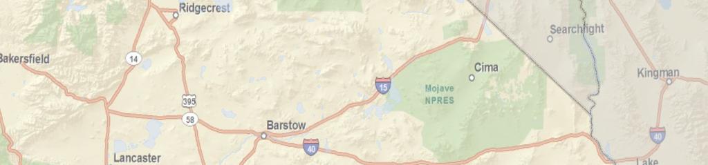
9 Species Range in California Utah Nevada Current Occurrence Point Historic and Unknown Occurrence Point Note: Occurrence point size graphically represents the precision level code for the data point but is not scaled geographically. Arizona Z:\Projects\CEC\j6668_DRECP\MAPDOC\MAPS\BaselineBioReport\SpeciesProfiles I January 15, Miles P a c i f i c O c e a n Sources: DRECP Species Occurrence Database (2011), CWHR (2008), CEC (2010), USGS (2010), ESRI (2010) Desert Renewable Energy Conservation Plan (DRECP) Baseline Biology Report MEXICO FIGURE SP-P19 Orocopia Sage in the Plan Area (N=17)
Owens Valley Checkerbloom Sidalcea covillei
 Owens Valley Checkerbloom Sidalcea covillei Legal Status Taxonomy Distribution General Photo permissions pending. State: Endangered; S3 1 California Rare Plant Rank: 1B.1 2 Federal: Bureau of Land Management
FEBRUARY 2014 BIOLOGICAL MONITORING PROTOCOL. for. Salvia greatae
 COACHELLA VALLEY CONSERVATION COMMISSION FEBRUARY 2014 BIOLOGICAL MONITORING PROTOCOL for Salvia greatae (Orocopia Sage) and Xylorhiza cognata (Mecca Aster) Prepared by the University of California Riverside
THE WILDLIFE SOCIETY CONFERENCE 2015
 THE WILDLIFE SOCIETY CONFERENCE 2015 Evaluation of Desert Tortoise Habitat Suitability Model Predictions in the Soda Mountain Area, San Bernardino County Susanne Heim Introduction Overview of Species Habitat
Common Name: FRINGED GENTIAN. Scientific Name: Gentianopsis crinita (Froelich) Ma. Other Commonly Used Names: none
 Ma. Other Commonly Used Names: none") b Common Name: FRINGED GENTIAN Scientific Name: Gentianopsis crinita (Froelich) Ma Other Commonly Used Names: none Previously Used Scientific Names: Gentiana crinita Froelich Family: Gentianaceae (gentian)
b Common Name: FRINGED GENTIAN Scientific Name: Gentianopsis crinita (Froelich) Ma Other Commonly Used Names: none Previously Used Scientific Names: Gentiana crinita Froelich Family: Gentianaceae (gentian)
POPULATION TRENDS FOR TULARE PSEUDOBAHIA AND STRIPED ADOBE LILY
 POPULATION TRENDS FOR TULARE PSEUDOBAHIA AND STRIPED ADOBE LILY Kern County has more endangered, threatened and rare plant species than most states. The geography and environmental conditions in the county
Common Name: GLADE MEADOW-PARSNIP. Scientific Name: Thaspium pinnatifidum (Buckley) Gray. Other Commonly Used Names: cutleaf meadow-parsnip
 Gray. Other Commonly Used Names: cutleaf meadow-parsnip") Common Name: GLADE MEADOW-PARSNIP Scientific Name: Thaspium pinnatifidum (Buckley) Gray Other Commonly Used Names: cutleaf meadow-parsnip Previously Used Scientific Names: none Family: Apiaceae/Umbelliferae
Common Name: GLADE MEADOW-PARSNIP Scientific Name: Thaspium pinnatifidum (Buckley) Gray Other Commonly Used Names: cutleaf meadow-parsnip Previously Used Scientific Names: none Family: Apiaceae/Umbelliferae
Field Survey for Laramie Columbine. (Aquilegia laramiensis) In the Rawlins Field Office
 In the Rawlins Field Office") Field Survey for Laramie Columbine (Aquilegia laramiensis) In the Rawlins Field Office prepared for the Wyoming Natural Diversity Database, University of Wyoming, and the Bureau of Land Management, Rawlins
Field Survey for Laramie Columbine (Aquilegia laramiensis) In the Rawlins Field Office prepared for the Wyoming Natural Diversity Database, University of Wyoming, and the Bureau of Land Management, Rawlins
LANDSCAPE CHANGE IN THE SOUTHWEST: Historical changes in selected ecosystems of the southwestern United States
 LANDSCAPE CHANGE IN THE SOUTHWEST: Historical changes in selected ecosystems of the southwestern United States Robert H. Webb U.S. Geological Survey 520 N. Park Avenue Tucson, AZ 85719 rhwebb@usgs.gov
Previously Used Scientific Names: Viburnum dentatum L. var. bracteatum
 Common Name: LIMEROCK ARROW-WOOD Scientific Name: Viburnum bracteatum Rehder Other Commonly Used Names: none Previously Used Scientific Names: Viburnum dentatum L. var. bracteatum Family: Caprifoliaceae
Analysis of Habitat Suitability and Connectivity in the Soda Mountain Area, San Bernardino County, California
 Analysis of Habitat Suitability and Connectivity in the Soda Mountain Area, San Bernardino County, California Susanne Heim and Laurie Hietter August 2012 One Embarcadero Center, Suite 740 San Francisco,
Nebraska Conservation and Environmental Review Tool (CERT): Terminology used in the Tables of the CERT Report
: Terminology used in the Tables of the CERT Report") Nebraska Conservation and Environmental Review Tool (CERT): Terminology used in the Tables of the CERT Report Nebraska Natural Heritage Program Nebraska Game and Parks Commission February 8, 2018 Contents
Nebraska Conservation and Environmental Review Tool (CERT): Terminology used in the Tables of the CERT Report Nebraska Natural Heritage Program Nebraska Game and Parks Commission February 8, 2018 Contents
Lesson 9: California Ecosystem and Geography
 California Education Standards: Kindergarten, Earth Sciences 3. Earth is composed of land air, and water. As a basis for understanding this concept: b. Students know changes in weather occur from day to
Bombing for Biodiversity in the United States: Response to Zentelis & Lindenmayer 2015
 CORRESPONDENCE Bombing for Biodiversity in the United States: Response to Zentelis & Lindenmayer 2015 Jocelyn L. Aycrigg 1, R. Travis Belote 2, Matthew S. Dietz 3, Gregory H. Aplet 4, & Richard A. Fischer
Big Chino Valley Pumped Storage Project (FERC No ) Vegetation Mapping and Habitat Assessment Study Plan
 Vegetation Mapping and Habitat Assessment Study Plan") March 21, 2018 1.0 Introduction Big Chino Valley Pumped Storage LLC (BCV), a subsidiary of ITC Holdings Corp. (ITC), submitted a preliminary permit application to the Federal Energy Regulatory Commission
March 21, 2018 1.0 Introduction Big Chino Valley Pumped Storage LLC (BCV), a subsidiary of ITC Holdings Corp. (ITC), submitted a preliminary permit application to the Federal Energy Regulatory Commission
1. PURPOSE 2. PERIOD OF PERFORMANCE
 Statement of Work Herbarium Voucher Collection Land Management Section, Environmental Security Department Marine Corps Installations West Marine Corps Base Camp Pendleton, California 1. PURPOSE The purpose
Appendix J Vegetation Change Analysis Methodology
 Appendix J Vegetation Change Analysis Methodology Regional Groundwater Storage and Recovery Project Draft EIR Appendix-J April 2013 APPENDIX J- LAKE MERCED VEGETATION CHANGE ANALYSIS METHODOLOGY Building
Progress on Defense-Related Uranium Mines Program
 Progress on Defense-Related Uranium Mines Program Russel Edge US Department of Energy (DOE) Office of Legacy Management (LM) John Elmer Navarro Research and Engineering, Inc., Contractor to LM Uranium
Case Study: Ecological Integrity of Grasslands in the Apache Highlands Ecoregion
 Standard 9: Screen all target/biodiversity element occurrences for viability or ecological integrity. Case Study: Ecological Integrity of Grasslands in the Apache Highlands Ecoregion Summarized from: Marshall,
California Fuchsia Onagraceae Evening Primrose Family Epilobium canum
 6. California Fuchsia Onagraceae Evening Primrose Family Epilobium canum California Fuchsia, also known as Hummingbird Flower, Hummingbird Trumpet, and Firechalice, is a species of willowherb that is native
Chapter 8. Biogeographic Processes. Upon completion of this chapter the student will be able to:
 Chapter 8 Biogeographic Processes Chapter Objectives Upon completion of this chapter the student will be able to: 1. Define the terms ecosystem, habitat, ecological niche, and community. 2. Outline how
Fickeisen Plains Cactus (Pediocactus peeblesianus ssp. fickeiseniae)
") Fickeisen Plains Cactus (Pediocactus peeblesianus ssp. fickeiseniae) Monitoring Report Salt Trail Canyon Monitoring Site 2006-2008 Daniela Roth Navajo Natural Heritage Program Department of Fish & Wildlife
Fickeisen Plains Cactus (Pediocactus peeblesianus ssp. fickeiseniae) Monitoring Report Salt Trail Canyon Monitoring Site 2006-2008 Daniela Roth Navajo Natural Heritage Program Department of Fish & Wildlife
An Introduction to NatureServe Linking Conservation and Transportation Planning Phoenix, Arizona November 8 & 9, 2006
 An Introduction to NatureServe Linking Conservation and Transportation Planning Phoenix, Arizona November 8 & 9, 2006 1 NatureServe in Brief An independent, non-profit conservation organization Provides
Data Dictionary for Observation Data Transcription Reports from the Colorado Natural Heritage Program
 Data Dictionary for Observation Data Transcription Reports from the Colorado Natural Heritage Program This Data Dictionary defines terms used in Observation Data Reports exported by the Colorado Natural
Improvement of the National Hydrography Dataset for Parts of the Lower Colorado Region and Additional Areas of Importance to the DLCC
 Improvement of the National Hydrography Dataset for Parts of the Lower Colorado Region and Additional Areas of Importance to the DLCC Carlos Reyes-Andrade California State University, Northridge September
Desert Biomes of North America and Beyond
 Desert Biomes of North America and Beyond Optional reading: McAuliffe 1994, Landscape Evolution, Soil Formation, and Ecological Patterns and Processes in Sonoran Desert Bajadas (review figures) 10/21/09
Sand Transport Paths in the Mojave Desert
 Sand Transport Paths in the Mojave Desert Lack of Monitoring Stations, Soil Analyses, and the Outdated Rule 403.2 Put Communities and the Environment at Risk Lucerne Valley MAC July 20, 2017 Pat Flanagan
Invasive Plant Management at Joshua Tree National Park
 Invasive Plant Management at Joshua Tree National Park Neil Frakes Vegetation Branch Chief Joshua Tree National Park, Division of Science and Resource Stewardship neil_frakes@nps.gov Joshua Tree National
Development of statewide 30 meter winter sage grouse habitat models for Utah
 Development of statewide 30 meter winter sage grouse habitat models for Utah Ben Crabb, Remote Sensing and Geographic Information System Laboratory, Department of Wildland Resources, Utah State University
15 Non-Native Plants at Lake Mead National Recreation Area
 15 Non-Native Plants at Lake Mead National Recreation Area To report weed locations use non-native plant survey form and/or contact: Carrie Norman Exotic Plant Manager carrie_norman@nps.gov 702-293-8734
[LLAZC X.L EA0000; AZ SRP ] Notice of Temporary Closures: Selected Public Lands in La Paz County, AZ
![[LLAZC X.L EA0000; AZ SRP ] Notice of Temporary Closures: Selected Public Lands in La Paz County, AZ](/thumbs/89/100188672.jpg "[LLAZC X.L EA0000; AZ SRP ] Notice of Temporary Closures: Selected Public Lands in La Paz County, AZ") This document is scheduled to be published in the Federal Register on 12/29/2017 and available online at https://federalregister.gov/d/2017-28217, and on FDsys.gov 4310-32 DEPARTMENT OF THE INTERIOR Bureau
This document is scheduled to be published in the Federal Register on 12/29/2017 and available online at https://federalregister.gov/d/2017-28217, and on FDsys.gov 4310-32 DEPARTMENT OF THE INTERIOR Bureau
SAGUARO AND AGAVE SURVEY: PROPOSED SANTA RITA ROAD WATERLINE FOR THE ROSEMONT PROJECT TABLE OF CONTENTS LIST OF FIGURES
 SAGUARO AND AGAVE SURVEY: PROPOSED SANTA RITA ROAD WATERLINE FOR THE ROSEMONT PROJECT PREPARED FOR: PREPARED BY: Rosemont Copper Company WestLand Resources, Inc. DATE: February 3, 2010 PROJECT NO. 1049.14
Priority areas for grizzly bear conservation in western North America: an analysis of habitat and population viability INTRODUCTION METHODS
 Priority areas for grizzly bear conservation in western North America: an analysis of habitat and population viability. Carroll, C. 2005. Klamath Center for Conservation Research, Orleans, CA. Revised
Common Name: GLADE WINDFLOWER. Scientific Name: Anemone berlandieri Pritzel. Other Commonly Used Names: southern thimble-weed
 Common Name: GLADE WINDFLOWER Scientific Name: Anemone berlandieri Pritzel Other Commonly Used Names: southern thimble-weed Previously Used Scientific Names: Anemone caroliniana Walter var. heterophylla
Native species (Forbes and Graminoids) Less than 5% woody plant species. Inclusions of vernal pools. High plant diversity
 Less than 5% woody plant species. Inclusions of vernal pools. High plant diversity") WILLAMETTE VALLEY WET-PRAIRIE RESTORATION MODEL WHAT IS A WILLAMETTE VALLEY WET-PRAIRIE Hot Spot s Native species (Forbes and Graminoids) Rare plant species Less than 5% woody plant species Often dominated
WILLAMETTE VALLEY WET-PRAIRIE RESTORATION MODEL WHAT IS A WILLAMETTE VALLEY WET-PRAIRIE Hot Spot s Native species (Forbes and Graminoids) Rare plant species Less than 5% woody plant species Often dominated
Common Name: OZARK BUNCHFLOWER. Scientific Name: Veratrum woodii J.W. Robbins ex Wood. Other Commonly Used Names: Wood s false hellebore
 Common Name: OZARK BUNCHFLOWER Scientific Name: Veratrum woodii J.W. Robbins ex Wood Other Commonly Used Names: Wood s false hellebore Previously Used Scientific Names: Melanthium woodii (J.W. Robbins
Other Commonly Used Names: Simpson s zephyr-lily, Florida atamasco-lily, rain zephyr-lily, rain lily
 Common Name: SIMPSON S RAIN LILY Scientific Name: Zephyranthes simpsonii Chapman Other Commonly Used Names: Simpson s zephyr-lily, Florida atamasco-lily, rain zephyr-lily, rain lily Previously Used Scientific
VEGETATION EVA BOEHRINGER
 VEGETATION EVA BOEHRINGER April 2, 2014 WUP CONSULTATIVE COMMITTEE WUP Consultative Committee (WUP CC) recognized that riparian and wetland vegetation in the reservoir drawdown zone is valuable for fish,
Great California Delta Trail Blueprint for Contra Costa and Solano Counties GIS AND MAPPING MEMORANDUM JULY 2010
 Great California Delta Trail Blueprint for Contra Costa and Solano Counties GIS AND MAPPING MEMORANDUM JULY 2010 {DRAFT} July 2010 Introduction Geographic Information Systems (GIS) are computer-based
Conservation and Recovery of Ione Endemic Plants: Mapping the Ione Plant Community
 Conservation and Recovery of Ione Endemic Plants: Mapping the Ione Plant Community Final Report Prepared for California Department of Fish and Game Contract and addendum September 1, 2004 Barbara Holzman,
Common Name: GOLDENSEAL
 Common Name: GOLDENSEAL Scientific Name: Hydrastis canadensis Linnaeus Other Commonly Used Names: none Previously Used Scientific Names: none Family: Ranunculaceae (buttercup) or Hydrastidaceae (goldenseal)
Grant Opportunity Monitoring Bi-State Sage-grouse Populations in Nevada
 Grant Opportunity Monitoring Bi-State Sage-grouse Populations in Nevada Proposals are due no later than November 13, 2015. Grant proposal and any questions should be directed to: Shawn Espinosa @ sepsinosa@ndow.org.
Assessing state-wide biodiversity in the Florida Gap analysis project
 University of Nebraska - Lincoln DigitalCommons@University of Nebraska - Lincoln Nebraska Cooperative Fish & Wildlife Research Unit -- Staff Publications Nebraska Cooperative Fish & Wildlife Research Unit
Southwest LRT Habitat Analysis. May 2016 Southwest LRT Project Technical Report
 Southwest LRT Habitat Analysis Southwest LRT Project Technical Report This page intentionally blank. Executive Summary This technical report describes the habitat analysis that was performed to support
An Introduction to Day Two. Linking Conservation and Transportation Planning Lakewood, Colorado August 15-16, 16, 2006
 An Introduction to Day Two Linking Conservation and Transportation Planning Lakewood, Colorado August 15-16, 16, 2006 1 Agenda Day One Transportation Planning Heritage Program State Wildlife Action Plan
Alamito Creek Preserve Ranches for Sale Marfa, Presidio County, Texas
 Alamito Creek Preserve Ranches for Sale Marfa, Presidio County, Texas James King, Agent Office 432 426.2024 Cell 432 386.2821 James@KingLandWater.com Alamito Creek Preserve Various size Ranch Properties,
a) Piedmont: e) Monument: f) Plateau: g) Mesa: h) Butte: i) Playa: j) Perennial Stream:
 Piedmont: e) Monument: f) Plateau: g) Mesa: h) Butte: i) Playa: j) Perennial Stream:") Name: Lab day: Tuesday Wednesday CEEES/SC 10110L-20110L Planet Earth Laboratory Laboratory #11: Arid Environments & Landforms Readings: See handout at http://www.nd.edu/~cneal/physicalgeo/lab-deserts/index.html.
Name: Lab day: Tuesday Wednesday CEEES/SC 10110L-20110L Planet Earth Laboratory Laboratory #11: Arid Environments & Landforms Readings: See handout at http://www.nd.edu/~cneal/physicalgeo/lab-deserts/index.html.
Family: Parnassiaceae (grass-of-parnassus) or Saxifragaceae (rockbreaker)
 or Saxifragaceae (rockbreaker)") Common Name: LARGE-LEAF GRASS-OF-PARNASSUS Scientific Name: Parnassia grandifolia A.P. de Candolle Other Commonly Used Names: bigleaf grass-of-parnassus, limeseep parnassia, undine Previously Used Scientific
Common Name: LARGE-LEAF GRASS-OF-PARNASSUS Scientific Name: Parnassia grandifolia A.P. de Candolle Other Commonly Used Names: bigleaf grass-of-parnassus, limeseep parnassia, undine Previously Used Scientific
NORTH CAROLINA PLANT CONSERVATION PROGRAM RARE PLANT REINTRODUCTION, AUGMENTATION, AND TRANSPLANTATION GUIDELINES
 NORTH CAROLINA PLANT CONSERVATION PROGRAM RARE PLANT REINTRODUCTION, AUGMENTATION, AND TRANSPLANTATION GUIDELINES March, 2005 This document was prepared by the North Carolina Plant Conservation Program
Common Name: PINK LADY S-SLIPPER
 Common Name: PINK LADY S-SLIPPER Scientific Name: Cypripedium acaule Aiton Other Commonly Used Names: pink moccasin flower, stemless lady-slipper, slipper orchid Previously Used Scientific Names: Fissipes
The Invasion of False Brome in Western Oregon
 The Invasion of False Brome in Western Oregon GIS II Presentation Winter 2006 Will Fellers Kurt Hellerman Kathy Strope Statia Cupit False Brome (Brachypodium sylvaticum) Perennial bunchgrass native to
Tutorial: Species Modeling Approach. Scott Fleury ICF International April 13, 2011
 Tutorial: Species Modeling Approach Scott Fleury ICF International April 13, 2011 Filling the Data Gaps: The Role of Species Distribution Modeling Why develop species distribution models? To provide an
Other Commonly Used Names: wintergreen quillwort, evergreen quillwort
 Common Name: WINTER QUILLWORT Scientific Name: Isoetes hyemalis D.F. Brunton Other Commonly Used Names: wintergreen quillwort, evergreen quillwort Previously Used Scientific Names: none Family: Isoetaceae
[LLAZC03000.L EA0000 LVRCA13SA A, AZ SRP Notice of Temporary Closures of Public Lands in La Paz County, AZ
 This document is scheduled to be published in the Federal Register on 01/15/2013 and available online at http://federalregister.gov/a/2013-00542, and on FDsys.gov 4310-32-P DEPARTMENT OF THE INTERIOR Bureau
National Wildland Significant Fire Potential Outlook
 National Wildland Significant Fire Potential Outlook National Interagency Fire Center Predictive Services Issued: September, 2007 Wildland Fire Outlook September through December 2007 Significant fire
THE NATURESERVE NETWORK
 THE NATURESERVE NETWORK Access to NatureServe's best available data on the locations of endangered species September 1, 2011 A Network Connecting Science with Conservation Mexico Guatemala El Salvador
DRABA RAMOSISSIMA (BRASSICACEAE) NEW TO ALABAMA
 NEW TO ALABAMA") Dattilo, A.J. and B.R. Keener. 2017. Draba ramosissima (Brassicaceae) new to Alabama. Phytoneuron 2017-6: 1 5. Published 18 January 2017. ISSN 2153 733X DRABA RAMOSISSIMA (BRASSICACEAE) NEW TO ALABAMA
Dattilo, A.J. and B.R. Keener. 2017. Draba ramosissima (Brassicaceae) new to Alabama. Phytoneuron 2017-6: 1 5. Published 18 January 2017. ISSN 2153 733X DRABA RAMOSISSIMA (BRASSICACEAE) NEW TO ALABAMA
National Wildland Significant Fire Potential Outlook
 National Wildland Significant Fire Potential Outlook National Interagency Fire Center Predictive Services Issued: April 1, 2008 Next Issue: May 1, 2008 Wildland Fire Outlook April 2008 through July 2008
Crystal Moncada. California State University San Bernardino. January- July Brett R. Goforth- Department of Geography and Environmental Studies
 A Geographical Information System (GIS) Based Evaluation of Landslide Susceptibility Mapped on the Harrison Mountain Quadrangle of the Santa Ana River Watershed Crystal Moncada California State University
The Protection of Ecosystem Services in the US- Mexico Border
 The Protection of Ecosystem Services in the US- Mexico Border Lina Ojeda-Revah El Colegio de la Frontera Norte Christopher Brown New Mexico State University ACES 2010 Annual Meeting Gila River Indian Community
Distribution Modeling for the Sierra Bighorn Sheep. threatened by predators, specifically mountain lions. Main aim of this research was to find
 Chontanat Suwan GEOG 408B, Spring 2013 28 April 2013 Distribution Modeling for the Sierra Bighorn Sheep Abstract The Sierra Nevada bighorn sheep is in the list of endangered species which mainly threatened
Common Name: FLORIDA ADDER S-MOUTH ORCHID. Scientific Name: Malaxis spicata Swartz. Other Commonly Used Names: none
 Common Name: FLORIDA ADDER S-MOUTH ORCHID Scientific Name: Malaxis spicata Swartz Other Commonly Used Names: none Previously Used Scientific Names: Malaxis floridana (Chapman) Kuntze, Microstylis floridana
Common Name: THREE BIRDS ORCHID
 Common Name: THREE BIRDS ORCHID Scientific Name: Triphora trianthophora (Swartz) Rydberg Other Commonly Used Names: nodding pogonia, nodding ettercap Previously Used Scientific Names: Arethusa trianthophoros
Previously Used Scientific Names: Schwalbea australis Pennell, Schwalbea americana L. var. australis (Pennell) Reveal & Broome
 Reveal & Broome") Common Name: CHAFFSEED Scientific Name: Schwalbea americana Linnaeus Other Commonly Used Names: American chaffseed Previously Used Scientific Names: Schwalbea australis Pennell, Schwalbea americana L.
Common Name: CHAFFSEED Scientific Name: Schwalbea americana Linnaeus Other Commonly Used Names: American chaffseed Previously Used Scientific Names: Schwalbea australis Pennell, Schwalbea americana L.
Environmental Management 123 West Indiana Ave., Room 202 DeLand, FL (386) Environmental Management Outdoor Education
 Environmental Management Outdoor Education") Environmental Management 123 West Indiana Ave., Room 202 DeLand, FL 32720 (386) 736-5927 Environmental Management Outdoor Education 2015-2016 Environmental Management Education Offerings Botany Botany,
Environmental Management 123 West Indiana Ave., Room 202 DeLand, FL 32720 (386) 736-5927 Environmental Management Outdoor Education 2015-2016 Environmental Management Education Offerings Botany Botany,
Summary Description Municipality of Anchorage. Anchorage Coastal Resource Atlas Project
 Summary Description Municipality of Anchorage Anchorage Coastal Resource Atlas Project By: Thede Tobish, MOA Planner; and Charlie Barnwell, MOA GIS Manager Introduction Local governments often struggle
Common Name: YELLOW LADY S-SLIPPER. Scientific Name: Cypripedium parviflorum Salisbury. Other Commonly Used Names: golden slipper
 Common Name: YELLOW LADY S-SLIPPER Scientific Name: Cypripedium parviflorum Salisbury Other Commonly Used Names: golden slipper Previously Used Scientific Names: Cypripedium calceolus Linnaeus Family:
Common Name: SHOALS SPIDER-LILY. Scientific Name: Hymenocallis coronaria (J. LeConte) Kunth. Other Commonly Used Names: Cahaba lily, Catawba lily
 Kunth. Other Commonly Used Names: Cahaba lily, Catawba lily") Common Name: SHOALS SPIDER-LILY Scientific Name: Hymenocallis coronaria (J. LeConte) Kunth Other Commonly Used Names: Cahaba lily, Catawba lily Previously Used Scientific Names: Hymenocallis caroliniana
Common Name: SHOALS SPIDER-LILY Scientific Name: Hymenocallis coronaria (J. LeConte) Kunth Other Commonly Used Names: Cahaba lily, Catawba lily Previously Used Scientific Names: Hymenocallis caroliniana
MONITORING THE EFFECTS OF CLIMATE CHANGE ON SPRINGS, SEEPS AND OTHER WATER NATIONAL PRESERVE
 MONITORING THE EFFECTS OF CLIMATE CHANGE ON SPRINGS, SEEPS AND OTHER WATER RESOURCES IN THE MOJAVE NATIONAL PRESERVE Boris Poff and Debra Hughson Mojave National Preserve, California CLIMATE CHANGE Predictions
remain on the trees all year long) Example: Beaverlodge, Alberta, Canada
 Example: Beaverlodge, Alberta, Canada") Coniferous Forest Temperature: -40 C to 20 C, average summer temperature is 10 C Precipitation: 300 to 900 millimeters of rain per year Vegetation: Coniferous-evergreen trees (trees that produce cones
Coniferous Forest Temperature: -40 C to 20 C, average summer temperature is 10 C Precipitation: 300 to 900 millimeters of rain per year Vegetation: Coniferous-evergreen trees (trees that produce cones
Name: Date: Class: Louisiana: Our History, Our Home Chapter 1: Louisiana s Geography - Section 2: Natural Regions Guided Reading
 Instructions: Read the section and complete each item with words from the passages in this section. 1. The diversity of Louisiana s can surprise residents and visitors alike. 2. Physical geography is concerned
APPENDIX E. GEOMORPHOLOGICAL MONTORING REPORT Prepared by Steve Vrooman, Keystone Restoration Ecology September 2013
 APPENDIX E GEOMORPHOLOGICAL MONTORING REPORT Prepared by Steve Vrooman, Keystone Restoration Ecology September 2 Introduction Keystone Restoration Ecology (KRE) conducted geomorphological monitoring in
CESPL-RG-A March 12, 2008 REGULATORY DIVISION MEMORANDUM. SUBJECT: Traditional Navigable Waters, Navigable In-Fact Determination for the Gila River
 CESPL-RG-A March 12, 2008 REGULATORY DIVISION MEMORANDUM SUBJECT: Traditional Navigable Waters, Navigable In-Fact Determination for the Gila River 1. To provide documentation to determine the status of
Atlas of the Upper Gila River Watershed
 Atlas of the Upper Gila River Watershed Katie Banister, David Chan, Jessica M. Driscoll, Christopher Fullerton, Aaron Lien and Kelly Mott Lacroix January 2014 The University of Arizona Water Resources
Chapter 6. Field Trip to Sandia Mountains.
 University of New Mexico Biology 310L Principles of Ecology Lab Manual Page -40 Chapter 6. Field Trip to Sandia Mountains. Outline of activities: 1. Travel to Sandia Mountains 2. Collect forest community
SAN FRANCISCO DISTRICT INFORMATION REQUESTED FOR VERIFICATION OF CORPS JURISDICTION
 DEPARTMENT OF THE ARMY SAN FRANCISCO DISTRICT, U.S. ARMY CORPS OF ENGINEERS 1455 MARKET STREET SAN FRANCISCO, CALIFORNIA 94103-1398 SAN FRANCISCO DISTRICT INFORMATION REQUESTED FOR VERIFICATION OF CORPS
2. PHYSICAL SETTING FINAL GROUNDWATER MANAGEMENT PLAN. 2.1 Topography. 2.2 Climate
 FINAL GROUNDWATER MANAGEMENT PLAN 2. PHYSICAL SETTING Lassen County is a topographically diverse area at the confluence of the Cascade Range, Modoc Plateau, Sierra Nevada and Basin and Range geologic provinces.
APPENDIX V VALLEYWIDE REPORT
 APPENDIX V VALLEYWIDE REPORT Page Intentionally Left Blank 1.2 San Joaquin Valley Profile Geography The San Joaquin Valley is the southern portion of the Great Central Valley of California (Exhibit 1-1).
Common Name: FLORIDA LADIES-TRESSES. Scientific Name: Spiranthes floridana (Wherry) Cory. Other Commonly Used Names: none
 Cory. Other Commonly Used Names: none") Common Name: FLORIDA LADIES-TRESSES Scientific Name: Spiranthes floridana (Wherry) Cory Other Commonly Used Names: none Previously Used Scientific Names: Spiranthes brevilabris var. floridana (Wherry)
Common Name: FLORIDA LADIES-TRESSES Scientific Name: Spiranthes floridana (Wherry) Cory Other Commonly Used Names: none Previously Used Scientific Names: Spiranthes brevilabris var. floridana (Wherry)
Mapping and Modeling for Regional Planning
 Mapping and Modeling for Regional Planning Carol W. Witham Sacramento Valley Chapter California Native Plant Society contributors: David Ackerly John Dittes Julie Evens Josephine Guardino Robert F. Holland
Using GIS to Focus Field Inventories of Rare and Endemic Plants at Badlands National Park, South Dakota
 Using GIS to Focus Field Inventories of Rare and Endemic Plants at Badlands National Park, South Dakota Sandee Dingman, Badlands National Park, P.O. Box 6, Interior, South Dakota 57750; sandee_dingman@nps.gov
Your web browser (Safari 7) is out of date. For more security, comfort and the best experience on this site: Update your browser Ignore
 is out of date. For more security, comfort and the best experience on this site: Update your browser Ignore") Your web browser (Safari 7) is out of date. For more security, comfort and the best experience on this site: Update your browser Ignore ALLU VIAL FAN colluvial fan, debris cone For the complete encyclopedic
Your web browser (Safari 7) is out of date. For more security, comfort and the best experience on this site: Update your browser Ignore ALLU VIAL FAN colluvial fan, debris cone For the complete encyclopedic
Coyote Creek Apache County, Arizona
 Coyote Creek Apache County, Arizona Listed for sale exclusively by: Traegen Knight Headquarters West Ltd. PO BOX 1980 St. Johns, AZ 85936 Phone: (928) 524-3740, Fax: (928) 563-7004, Cell: (602) 228-3494
Stephanie J. Connolly Forest Soil Scientist
 Stephanie J. Connolly Forest Soil Scientist Approximately 1 million acres High elevation Steep slopes Rain shadow effect Hydrologically shallow soils Sedimentary geology Acidic environments Biodiversity
Desert INTRODUCTION. Very few of the world's deserts are barren, windswept sand dunes. Only 30% of the Sahara is sand dunes like the ones shown here.
 Desert INTRODUCTION Scientists define a desert as a region that receives less than 25 centimeters (10 inches) of rain per year. About onethird of Earth s land surface is desert. Deserts may be hot or cold,
Common Name: GEORGIA QUILLWORT. Scientific Name: Isoetes georgiana Luebke. Other Commonly Used Names: none. Previously Used Scientific Names: none
 Common Name: GEORGIA QUILLWORT Scientific Name: Isoetes georgiana Luebke Other Commonly Used Names: none Previously Used Scientific Names: none Family: Isoetaceae (quillwort) Rarity Ranks: G2G3/S2S3 State
State Geography Due: Tuesday, October 24, 2017
 State Geography Due: Tuesday, October 24, 2017 Step 1: You will first go online to http://www.timeanddate.com/worldclock/distance.html. Click on calculators and from the drop down menu, click on distance
[LLNVS01000 L EA0000 LVRCF A 18X MO# ] Notice of Temporary Closure of Public Land in Clark County, Nevada
![[LLNVS01000 L EA0000 LVRCF A 18X MO# ] Notice of Temporary Closure of Public Land in Clark County, Nevada](/thumbs/96/127731372.jpg "[LLNVS01000 L EA0000 LVRCF A 18X MO# ] Notice of Temporary Closure of Public Land in Clark County, Nevada") This document is scheduled to be published in the Federal Register on 03/07/2019 and available online at https://federalregister.gov/d/2019-04135, and on govinfo.gov 4310-HC DEPARTMENT OF THE INTERIOR
This document is scheduled to be published in the Federal Register on 03/07/2019 and available online at https://federalregister.gov/d/2019-04135, and on govinfo.gov 4310-HC DEPARTMENT OF THE INTERIOR
NIDIS Intermountain West Drought Early Warning System November 21, 2017
 NIDIS Drought and Water Assessment NIDIS Intermountain West Drought Early Warning System November 21, 2017 Precipitation The images above use daily precipitation statistics from NWS COOP, CoCoRaHS, and
Areas of Conservation Emphasis (ACE-II) Project Report
 Project Report") Areas of Conservation Emphasis (ACE-II) Project Report California Department of Fish and Game September 2015 (v2) October 2010 (v1) ACE-II 2015 (v2) GIS and Scripting: Ryan Hill, Sandra Hill and Melanie
Areas of Conservation Emphasis (ACE-II) Project Report California Department of Fish and Game September 2015 (v2) October 2010 (v1) ACE-II 2015 (v2) GIS and Scripting: Ryan Hill, Sandra Hill and Melanie
Chapter 3. Description of the Study Area. Karl Taboga, James Stafford and Paul Taucher 3-19
 Chapter 3 Description of the Study Area Karl Taboga, James Stafford and Paul Taucher 3-19 T his study examines groundwater resources that underlie the Bear River drainage basin in Wyoming as well as areas
Illinois Drought Update, December 1, 2005 DROUGHT RESPONSE TASK FORCE Illinois State Water Survey, Department of Natural Resources
 Illinois Drought Update, December 1, 2005 DROUGHT RESPONSE TASK FORCE Illinois State Water Survey, Department of Natural Resources For more drought information please go to http://www.sws.uiuc.edu/. SUMMARY.
Appendix G. Summary of Hydrogeologic Conditions and Historical Mining Northwest of the Centro Subarea in the Randsburg, Red Mountain, and Atolia Area
 Appendix G Summary of Hydrogeologic Conditions and Historical Mining Northwest of the Centro Subarea in the Randsburg, Red Mountain, and Atolia Area 1.1 Background This appendix provides a summary of hydrogeologic
CLIMATOLOGICAL REPORT 2002
 Range Cattle Research and Education Center Research Report RC-2003-1 February 2003 CLIMATOLOGICAL REPORT 2002 Range Cattle Research and Education Center R. S. Kalmbacher Professor, IFAS, Range Cattle Research
Natural Resource Management. Northern Tasmania. Strategy. Appendix 2
 Natural Resource Management Strategy Northern Tasmania 2015 2020 Appendix 2 Appendix 2 Appendix 2. Carbon Planting Spatial Prioritisation In support of this Strategy s development and implementation, work
Successful restoration of plant communities
 Successful restoration of plant communities WHY POLLINATORS MATTER Andrea T. Kramer Ph.D. Candidate, 2008 July 19, 2007 Today s presentation Area of study: the Great Basin Why restoration is needed What
GENERAL INFORMATION From British Colombia south to California, west into Idaho and south of Sierra Nevada. (2,3,7)
") Plant Propagation Protocol for Cephalanthera austiniae ESRM 412 Native Plant Production Spring 2008 Family Names Family Scientific Name: Family Common Name: Scientific Names Genus: Species: Species Authority:
Plant Propagation Protocol for Cephalanthera austiniae ESRM 412 Native Plant Production Spring 2008 Family Names Family Scientific Name: Family Common Name: Scientific Names Genus: Species: Species Authority:
Appendix P San Joaquin Valley Greenprint
 Appendix P San Joaquin Valley Greenprint TCAG 2014 Regional Transportation Plan San Joaquin Valley Greenprint Data Supplement for SCS Planning And Impact Assessment 3/25/2013 This document is intended
Statistical Forecast of the 2001 Western Wildfire Season Using Principal Components Regression. Experimental Long-Lead Forecast Bulletin
 Statistical Forecast of the 2001 Western Wildfire Season Using Principal Components Regression contributed by Anthony L. Westerling 1, Daniel R. Cayan 1,2, Alexander Gershunov 1, Michael D. Dettinger 2
Looking at the big picture to plan land treatments
 Looking at the big picture to plan land treatments Eva Strand Department of Rangeland Ecology and Management University of Idaho evas@uidaho.edu, http://www.cnr.uidaho.edu/range Why land treatment planning?
LANDSLIDE HAZARD ANALYSIS AND ITS EFFECT ON ENDANGERED SPECIES HABITATS, GRAND COUNTY, UTAH
 12/5/2016 LANDSLIDE HAZARD ANALYSIS AND ITS EFFECT ON ENDANGERED SPECIES HABITATS, GRAND COUNTY, UTAH GIS Final Project Ashlyn Murphy Fall 2016 1. Introduction and Problem A well-known geologic hazard