ABCB Net-Indonesia Nanjing, 2-3 November 2015
|
|
|
- Melina Hutchinson
- 6 years ago
- Views:
Transcription
1 Indonesian Biodiversity Information System (IBIS): on going exploring and documenting Dedy Darnaedi & Pesigrihastamadya Research Center For Biology Indonesian Institute of Sciences (LIPI) ABCB Net-Indonesia Nanjing, 2-3 November 2015
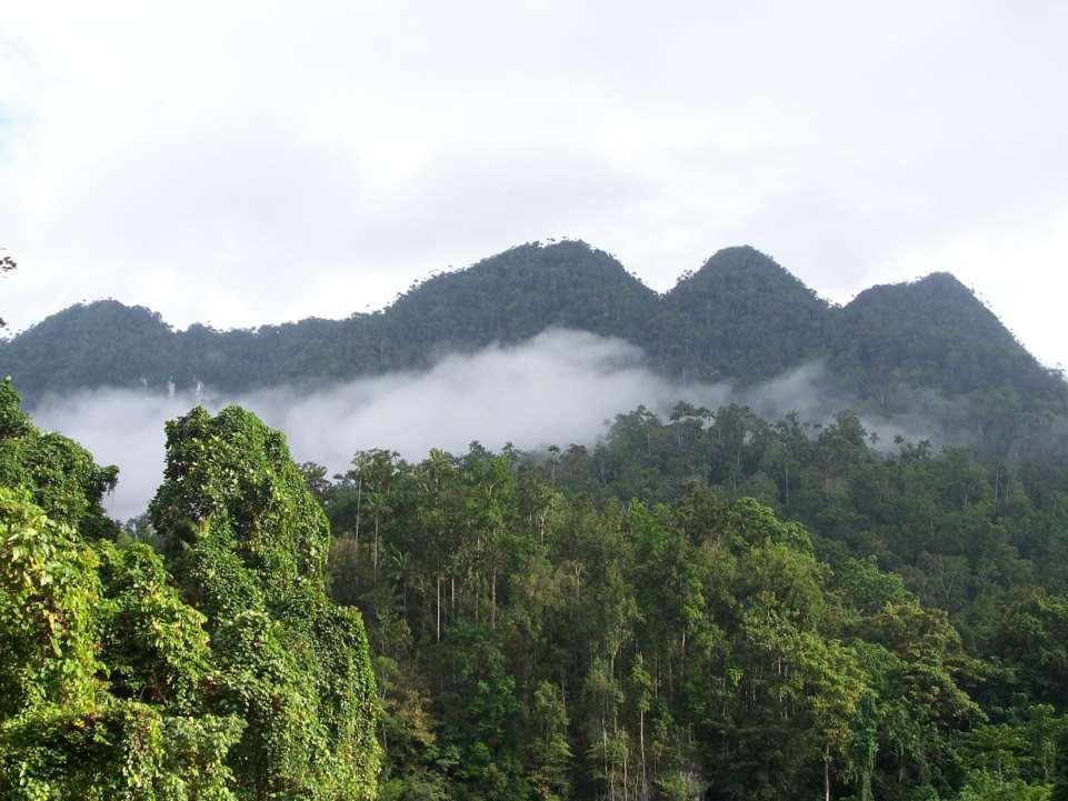

2 17% 16 % BIODIVERSITY 25 % 12 % 16 % 17 vegetation types (Hutan Dataran Rendah, Raja Ampat- Papua) Plant
3 Major Flora Activities Region Flora Malesiana Program Plant Resources of South East Asia (PROSEA) Local Flora : Flora of Indonesia; Flora of Java; Varen Flora Voor Java; Mountain Flora of Java; Flora of Bali Island; Flora of Gede-Pangrango National Park; Unique Flora of Celebes Guide Book Flora of Nantu, North Celebes Check list Fern Flora in Celebes Genetic Diversity of Sumatran Zingiberaceae (Phylogenetic Study) Plant Life in Botanical Gardens
4 Botanical Exploration began in the early 1950 Peta kerapatan nomor koleksi botani di Malesia S/D 1950 (Steenis-Kruseman, Cyclpedia of Botanical Exploration in Malesia,Flora Malesiana I (1).1950 KEPULAUAN SERIBU
5 Networking of Information IT Fields Database System Web Multimedia Biodiversity Informatics Research Networks & Hardware
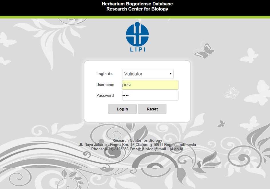
6 Database System Current systems: 1. Offline is using Open Source and License Software 2. Online Type Specimens is using Open Source Software
7 Type Specimens Online Application

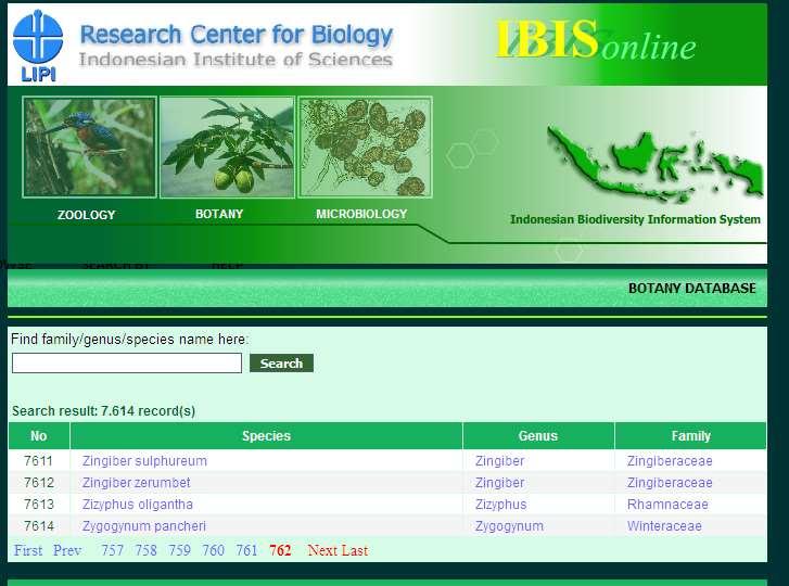
8 Home Page Database IBIS online

9 Home Page Database IBIS online botany

10 Browse By Taxa Database IBIS online Botany

11 Species & Specimen Details Database IBIS online botany

12 Species & Specimen Details Database IBIS online botany B

13
14
15
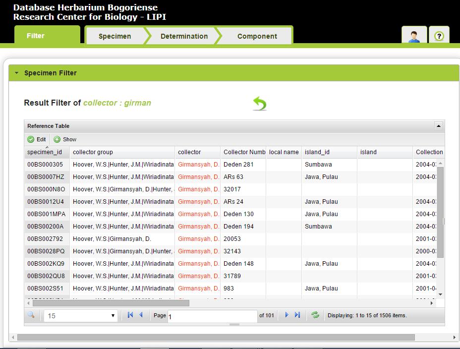
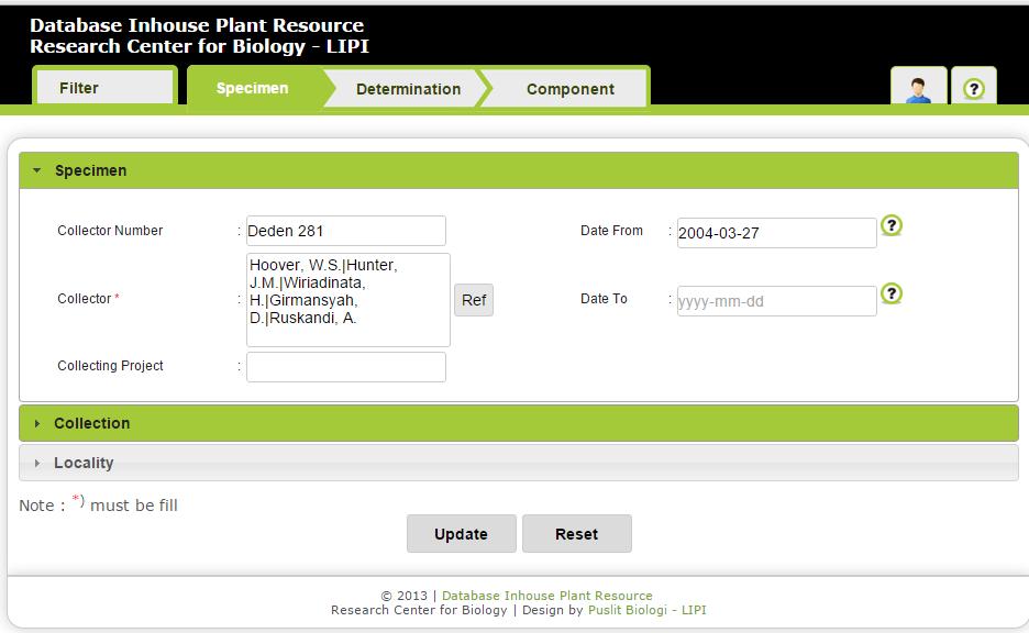
16
17
18
19
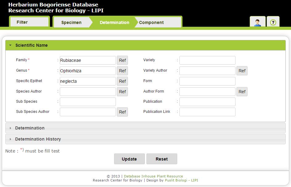
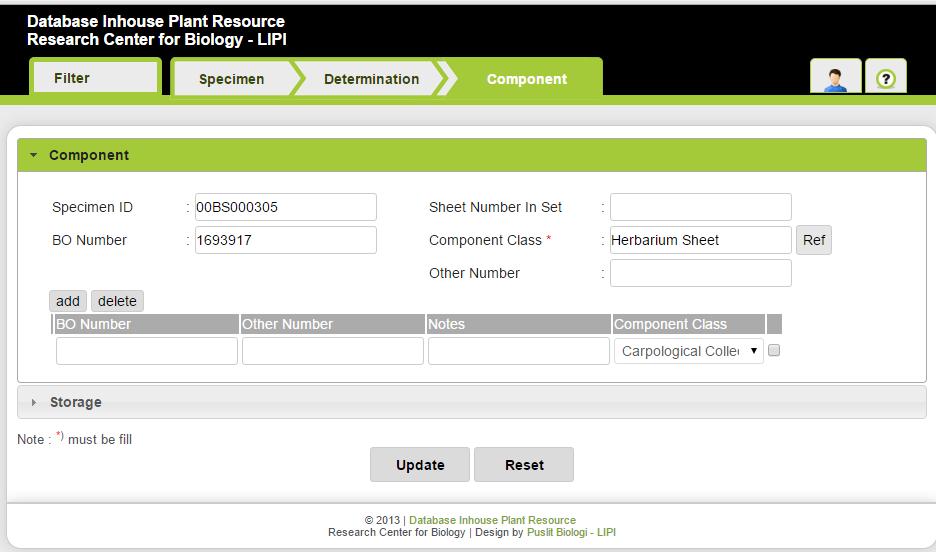
20
21 RCB Data Specimen 2015 Data Field Specimen Collection Offline Online (Type Specimens) Herbarium Zoology InaCC 889, ,000 (51%) 12,530 2,991, ,509 (12%) (67%) 385
22 Database Networking Open Source Software are used for: 1. Herbarium Database for Plant 2. Indonesian Biodiversity Information Facility (InaBIF) :
23 Intranet Application Herbarium Database Consist of Specimen, Determination and Component Information Developed by Open Source Software
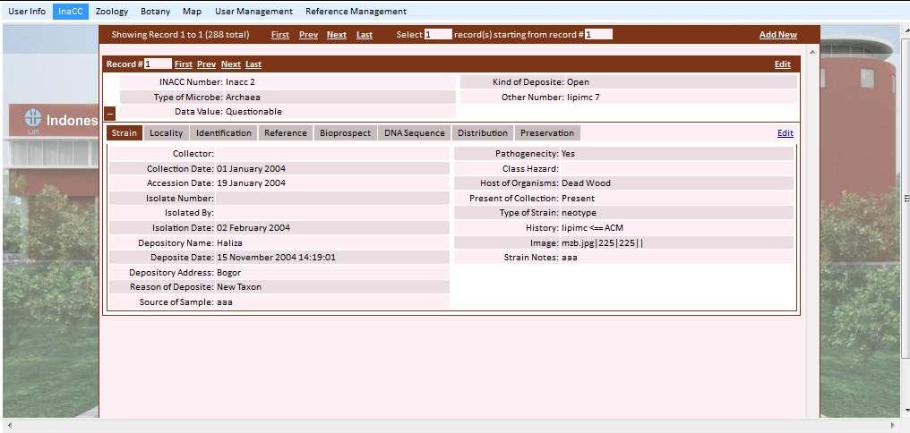
24

25 Filter Data Of Herbarium Database
26
27 Speciemen Information
28 Determination Information
29 Component Information
30 Desktop Application Indonesian Biodiversity Information System (IBIS) Developed by License Software Used for Zoology (animal data)

31 IBIS Desktop Application


32 SPECIMEN Animal Information at the time when collected in the field

33 DETERMINATION Animal Information for scientific name

34 COMPONENT Animal Information for physical also depository form and place

35 Map Distribution Overlay with National Geospacsial Map

36 Map Identify
37 Biodiversity Informatics (BI) Thesis : 1. Plant Species Classification by Leaf Shape and Vein Image A Case Study of the Dillenia Genus (Pesi, Dr. Teguh Triono & Prof. Aniati). 2. Frogs and Toads Species Classification based on Morphology by Statistic Methods, Fuzzy and Neural Networks (Yulia, Irfan Sidik, M.Sc & Prof. Aniati).

38 Research Center for Biology Indonesian Institute of Sciences

39 InaBIF Profile Head of Delegation 6 nodes Node Manager Technical Team Since 2013


40 InaBIF activities Data collecting Models Promotion Stabilization and systems maintenance Publish Dataset Make the guidelines dissemination Meetings, Agreement, FGD, and Workshop / Training 2015 Mapping data developing web-based InaBIF portal publication

 Informatics (14 th 15th")
41 InaBIF activities Implement FGD, Workshop / Training Seminar and Forum Group Discussion (FGD) InaBIF 5th February 2013 FGD Bio(diversity) Informatics (14 th 15th Februari 2013)


42 InaBIF activities Implement the meetings and agreement in data exchange mechanism between institutions Internal meetings InaBIF MoU Topic : Internal discussion InaBIF MoU between nodes in the neighborhood and some outside Deputy of Life Science-LIPi 4th September 2013 MoU meetings GBIF and LIPI. 5th September 2013
43 InaBIF activities Scientific papers Fuzzy approach as Preliminary Segmentation Method on Extraction Leaf venation Pesigrihastamadya N, M. Rahmat Widianto IPT as a Tool to Incorporating Data Biodiversity In Indonesia Yulia Aris Kartika, Pesigrihastamadya N Implementation of the NPT (Nodes Portal Toolkit) as Digital Library Portal of Indonesian Biodiversity Deden Sumirat, Pesigrihastamadya Normakristagaluh dan Yulia Aris Kartika


44 InaBIF activities developing InaBIF web-based portal


45 InaBIF activities Publish Dataset, Total genus specificepithet family basisofrecord identificationremarks islandgroup habitat


46 InaBIF activities Make the guidelines making books Darwin Core and InaBIF in Bahasa Indonesia


47 InaBIF activities InaBIF profile usage of data, tools and information about the importance of biodiversity information The dissemination
48 Other information needed Ecological record (scatered) Working specimens Secondary data (international, nasional publications) Validation of information (species name) etc
49 1. diversity of metadata 2. Protection of legal / intellectual property rights 3. Data Security 4. The internal and external policies 5. gap of node capacity
50 Thanks
51
52
")
53 Indonesian Culture Collection (InaCC)
54
55

56 Home Page Database IBIS online Zoology

57 Browse AVES Database IBIS online


58 AVES Species & Specimen Details of Database IBIS online
Biodiversity data, current gaps and work package efforts
 Biodiversity data, current gaps and work package efforts Florian T. Wetzel 1, Veljo Runnel 2, Anton Güntsch 3, Urmas Köljalg 2 1 Museum für Naturkunde Berlin - Leibniz Institute for Evolution and Biodiversity
世界在线植物志 (World Flora Online) 项目介绍
 项目介绍") Global Strategy for Plant Conservation 世界在线植物志 (World Flora Online) 项目介绍 覃海宁 中国科学院植物研究所 Email: hainingqin@ibcas.ac.cn Website: www.cvh.org.cn #gppc Global Strategy for Plant Conservation A programme of
Global Strategy for Plant Conservation 世界在线植物志 (World Flora Online) 项目介绍 覃海宁 中国科学院植物研究所 Email: hainingqin@ibcas.ac.cn Website: www.cvh.org.cn #gppc Global Strategy for Plant Conservation A programme of
COURSE CONTENT for Computer Science & Engineering [CSE]
![COURSE CONTENT for Computer Science & Engineering [CSE]](/thumbs/92/110586049.jpg "COURSE CONTENT for Computer Science & Engineering [CSE]") COURSE CONTENT for Computer Science & Engineering [CSE] 1st Semester 1 HU 101 English Language & Communication 2 1 0 3 3 2 PH 101 Engineering Physics 3 1 0 4 4 3 M 101 Mathematics 3 1 0 4 4 4 ME 101 Mechanical
COURSE CONTENT for Computer Science & Engineering [CSE] 1st Semester 1 HU 101 English Language & Communication 2 1 0 3 3 2 PH 101 Engineering Physics 3 1 0 4 4 3 M 101 Mathematics 3 1 0 4 4 4 ME 101 Mechanical
INTEGRATION OF BIODIVERSITY DATABASES IN TAIWAN AND LINKAGE TO GLOBAL DATABASES
 INTEGRATION OF BIODIVERSITY DATABASES IN TAIWAN AND LINKAGE TO GLOBAL DATABASES Kwang-Tsao Shao 1*, Ching-I Peng 1, Eric Yen 2, Kun-Chi Lai 1, Ming-Chih Wang 1, Jack Lin 1, Han Lee 1, Yang Alan 3, and
CHAPTER 22 GEOGRAPHIC INFORMATION SYSTEMS
 CHAPTER 22 GEOGRAPHIC INFORMATION SYSTEMS PURPOSE: This chapter establishes the administration and use of to improve the quality and accessibility of Department s spatial information and support graphical
Issues in bryophyte conservation and research
 Issues in bryophyte conservation and research Paula Warren Head Office Wellington Craig Miller West Coast Conservancy Hokitika Published by Head Office, PO Box 10-420 Wellington, New Zealand This report
Report of the Regional Committee of UN-GGIM for Asia and the Pacific (UN-GGIM-AP)
") Report of the Regional Committee of UN-GGIM for Asia and the Pacific (UN-GGIM-AP) At the Eighth Session of UN-GGIM UN Headquarters, New York, 1 3 August 2018 About UN-GGIM-AP One of the five regional committees
Report of the Regional Committee of UN-GGIM for Asia and the Pacific (UN-GGIM-AP) At the Eighth Session of UN-GGIM UN Headquarters, New York, 1 3 August 2018 About UN-GGIM-AP One of the five regional committees
INDONESIA S S UPDATE: GEOSPATIAL INFORMATION FOR SUSTAINABLE DEVELOPMENT RELATED TO INA SDI Dr. Asep Karsidi, M.Sc
 INDONESIA S S UPDATE: GEOSPATIAL INFORMATION FOR SUSTAINABLE DEVELOPMENT RELATED TO INA SDI Dr. Asep Karsidi, M.Sc GEOSPATIAL INFORMATION AGENCY 08 August, 2012 OUTLINE 1. Transformation Bakosurtanal into
PLANT BIOLOGY (PBIO) Plant Biology (PBIO) 1
 Plant Biology (PBIO) 1") Plant Biology (PBIO) 1 PLANT BIOLOGY (PBIO) PBIO 1052 How Plants Shaped Our World (LN) Description: This course is an eclectic dive into the world of plants and their influence on human society. Students
Plant Biology (PBIO) 1 PLANT BIOLOGY (PBIO) PBIO 1052 How Plants Shaped Our World (LN) Description: This course is an eclectic dive into the world of plants and their influence on human society. Students
WELCOME & INTRODUCTION
 MPA Management Capacity Building Training Module 1: WELCOME & INTRODUCTION Participants Distinguished Guests Welcome Site Overviews of MPAs represented Overview of Training Program What are Today s Objectives?
International Research Collaboration in Indonesia: LIPI as a special reference
 Workshop on Science & Technology Cooperation With Developing Countries on Global Issues. Tokyo, 8 October 2008 International Research Collaboration in Indonesia: LIPI as a special reference Hery Harjono
Biodiversity Information Service in China: The Architecture and Techniques
 Biodiversity Information Service in China: The Architecture and Techniques Experiences from the Construction of NSII Zheping Xu(xuzp@ibcas.ac.cn), Keping Ma,Haining Qin,Jinzhong Cui Institute of Botany,
CURRICULUM VITAE. 12 August 12 September, 1996: International course on "Hazardous Waste Management", Nykoping, Sweden.
 CURRICULUM VITAE Biodata: NAME: Ntsamaeeng Annah Moteetee (nee Lemena) DATE OF BIRTH: 12 th November, 1964 NATIONALITY: Lesotho MARITAL STATUS: Married Degrees Held: B.Sc. (Biology/Chemistry): NATIONAL
Creating an e-flora for South Africa
 SANBI POLICY DOCUMENT DIVISION: Biosystematics Research and Biodiversity Collections EFFECTIVE DATE: 1 April 2014 Compiler: Marianne le Roux & Janine Victor POLICY NUMBER: LAST AMENDED: Creating an e-flora
Digital Key to the Flora of Mongolia
 Najmi U., Rilke S. & Schnittler M. Digital Key to the Flora of Mongolia a follow-up of the project Virtual Guide to the Flora of Mongolia: Plant Database as practical approach Reliable determination of
Land Account : Indonesia
 Land Account : Indonesia Outline Environmental concerns Approach in compiling land account Results: Sumatera Land Account, Experimental Estimates Challenges Policy applications Further work Environmental
the map Redrawing Donald Hobern takes a look at the challenges of managing biodiversity data [ Feature ]
![the map Redrawing Donald Hobern takes a look at the challenges of managing biodiversity data [ Feature ]](/thumbs/82/86628837.jpg "the map Redrawing Donald Hobern takes a look at the challenges of managing biodiversity data [ Feature ]") Redrawing the map Donald Hobern takes a look at the challenges of managing biodiversity data 46 Volume 12 > Number 9 > 2008 www.asiabiotech.com Cicadetta sp., Canberra, Australia, December 2007 Photograph
Redrawing the map Donald Hobern takes a look at the challenges of managing biodiversity data 46 Volume 12 > Number 9 > 2008 www.asiabiotech.com Cicadetta sp., Canberra, Australia, December 2007 Photograph
GBIF Global Biodiversity Information Facility. Dmitry Schigel, Tim Hirsch Arctic data and Global Biodiversity Information Facility
 GBIF Global Biodiversity Information Facility Dmitry Schigel, Tim Hirsch Arctic data and Global Biodiversity Information Facility WHAT IS GBIF? Intergovernmental collaboration founded in 2001 on the recommendation
The Third UN-GGIM-AP Plenary Meeting. Use of Geospatial Information in Disaster and Coordination among NDMA and Relevant Organizations/Stakeholders
 The Third UN-GGIM-AP Plenary Meeting Use of Geospatial Information in Disaster and Coordination among NDMA and Relevant Organizations/Stakeholders Bali Indonesia 10 November 2014 Bernardus Wisnu Widjaja
Plant Systematics. What is Systematics? or Why Study Systematics? Botany 400. What is Systematics or Why Study Systematics?
 Plant Systematics Botany 400 http://botany.wisc.edu/courses/botany_400/ What is Systematics? or Why Kenneth J. Sytsma Melody Sain Kelsey Huisman Botany Department University of Wisconsin Pick up course
Developing Local Government Capacity for SDI Development in Indonesia. Mulyanto Darmawan*, Heri Sutanta,** Adi Rusmanto*
 Developing Local Government Capacity for SDI Development in Indonesia Mulyanto Darmawan*, Heri Sutanta,** Adi Rusmanto* * Centre for Standardization and Institutionalis Aspect of Geospatial Information,
The Atlas Aspect of the Atlas of Living Australia
 The Atlas Aspect of the Atlas of Living Australia Lee Belbin lee@blatantfabrications.com Melbourne Museum, July 28, 2010 The Atlas is funded by the Australian Government under the National Collaborative
The SIntegraM Stairway
 The SIntegraM Stairway Spatial Data Integration for the Maltese Islands The SIntegraM Stairway to Integrative Spatialisation: removing the barriers to access and harmonisation Prof. Dr. Saviour Formosa
CLASS XI BIOLOGY NOTES CHAPTER 1: LIVING WORLD
 CLASS XI BIOLOGY NOTES CHAPTER 1: LIVING WORLD Biology is the science of life forms and non-living processes. The living world comprises an amazing diversity of living organisms. In order to facilitate
SCOTCAT Credits: 20 SCQF Level 7 Semester 1 Academic year: 2018/ am, Practical classes one per week pm Mon, Tue, or Wed
 Biology (BL) modules BL1101 Biology 1 SCOTCAT Credits: 20 SCQF Level 7 Semester 1 10.00 am; Practical classes one per week 2.00-5.00 pm Mon, Tue, or Wed This module is an introduction to molecular and
THEME 1: Expression of needs and Data Infrastructures Informative references for Ecological Network Marche
 THEME 1: Expression of needs and Data Infrastructures Informative references for Ecological Network Marche Claudio Zabaglia Regione Marche - Project manager Head of Biodiversity, ecological network and
SDI DEVELOPMENT UPDATES OF INDONESIA
 SDI DEVELOPMENT UPDATES OF INDONESIA DR. ANTONIUS B. WIJANARTO Center For Management And Dissemination Of Geospatial Information GEOSPATIAL INFORMATION AUTHORITY GOVERNMENT OF THE REPUBLIC OF INDONESIA
The FIG - Questionnaire on NSDI
 The FIG - Questionnaire on NSDI Bernd Teichert University of Applied Sciences Dresden, Germany Contents NSDI - Definition Com. 3 - Brainstorming in Prague Canberra Implications and Conclusions The SDI
Wichita State University s Herbarium: Filling a Critical Gap
 Wichita State University s Herbarium: Filling a Critical Gap Presented by Mary Liz Jameson and Susan Matveyeva With collaboration from F. Leland Russell, Sai Deng, and Stephen Scott Great Plains Plant
climate famous data sharing toolbox in
 This is the story of what was done, and some lessons learnt as we bumped along on a very rough road. In the process of our work in mapping vegetation, modelling to investigate the possible impacts of climate
MEMORANDUM OF UNDERSTANDING FOR THE ESTABLISHMENT OF A CARPATHIAN INTEGRATED BIODIVERSITY INFORMATION SYSTEM
 MEMORUM OF UNDERSTING FOR THE ESTABLISHMENT OF A CARPATHIAN INTEGRATED BIODIVERSITY INFORMATION SYSTEM BETWEEN DAPHNE - INSTITUTE OF APPLIED ECOLOGY (hereinafter referred to DAPHNE) EUROPEAN ACADEMY BOLZANO
Harvesting and harnessing data for biogeographical research
 How do we know what grows where? Harvesting and harnessing data for biogeographical research A. Geography Tree B. Species Tree inventories and surveys natural areas, preserves, state forests, private properties
CHAPTER-1 THE LIVING WORLD MULTIPLE CHOICE QUESTIONS
 1 CHAPTER-1 THE LIVING WORLD MULTIPLE CHOICE QUESTIONS 1. As we go from species to kingdom in a taxonomic hierarchy, the number of common characteristics a. Will decrease b. Will increase c. Remain same
March 2007 The Survey Department of Sri Lanka
 Contribution of Survey Department of Sri Lanka for Mitigation of Disasters in Sri Lanka K.A.U.N.Kasthuri Deputy Surveyor General (Information Technology) March 2007 The Survey Department of Sri Lanka 1
Arcgis Tutorial Manual READ ONLINE
 Arcgis Tutorial Manual READ ONLINE ArcGIS Desktop 10 Trial Help - Note: The Quick Start Guide contains instructions that do not pertain to the trial edition. Many tutorials are found in the ArcGIS Desktop
Calculating Land Values by Using Advanced Statistical Approaches in Pendik
 Presented at the FIG Congress 2018, May 6-11, 2018 in Istanbul, Turkey Calculating Land Values by Using Advanced Statistical Approaches in Pendik Prof. Dr. Arif Cagdas AYDINOGLU Ress. Asst. Rabia BOVKIR
GBIF Info Session Brussels, 22 October 2010 BBPF
 GBIF Info Session Brussels, 22 October 2010 1 Agenda Part I Digitization Projects Saproxylic Beetles - Patrick Grootaert IFBL Plants (1939-1971) - Leo VanHecke Aves Birds Observations - Jean-Yves Paquet
Voices from Private Sector: Insights for Future NSDI Development in Indonesia
 Voices from Private Sector: Insights for Future NSDI Development in Indonesia Ta n d a n g Yu l i a d i D w i P u t ra, Ryosuke S h i b a s a k i I n st i t u t e o f I n d u st r i a l S c i e n c e,
Strengthening Geospatial Information Management in Indonesia
 b Strengthening Geospatial Information Management in Indonesia Prof. Dr. Hasanuddin Z. Abidin Head (President) Geospatial Information Agency of Indonesia The 5 th High Level Forum United Nations Global
Plant Biology Of The Basin And Range (Ecological Studies) READ ONLINE
 READ ONLINE") Plant Biology Of The Basin And Range (Ecological Studies) READ ONLINE If searched for the ebook Plant Biology of the Basin and Range (Ecological Studies) in pdf form, in that case you come on to faithful
Plant Biology Of The Basin And Range (Ecological Studies) READ ONLINE If searched for the ebook Plant Biology of the Basin and Range (Ecological Studies) in pdf form, in that case you come on to faithful
GIS AND REMOTE SENSING FOR OPEN SPACE PROTECTION ENVIRONMENTAL MANAGEMENT DEPARTMENT
 GIS AND REMOTE SENSING FOR OPEN SPACE PROTECTION ENVIRONMENTAL MANAGEMENT DEPARTMENT 22 nd May 2009 1 Introduction It is said that more than 80% of the City s activities throughout the world are spatially
Chitra Sood, R.M. Bhagat and Vaibhav Kalia Centre for Geo-informatics Research and Training, CSK HPKV, Palampur , HP, India
 APPLICATION OF SPACE TECHNOLOGY AND GIS FOR INVENTORYING, MONITORING & CONSERVATION OF MOUNTAIN BIODIVERSITY WITH SPECIAL REFERENCE TO MEDICINAL PLANTS Chitra Sood, R.M. Bhagat and Vaibhav Kalia Centre
econtentplus GS Soil
 econtentplus GS Soil General aims Assessment and strategic development of INSPIRE compliant Geodata-Services for European Soil Data BPN on basis of the EU 2007/2/EC (INSPIRE) Directive for Annex III theme
Proceedings of Association of Pacific Rim Universities (APRU) Research Symposium on University Museums: Forming a University Museum Collection
 Research Symposium on University Museums: Forming a University Museum Collection") Proceedings of Association of Pacific Rim Universities (APRU) Research Symposium on University Museums: Forming a University Museum Collection Network as the Core of Frontier Research O-10 The Beaty Biodiversity
Proceedings of Association of Pacific Rim Universities (APRU) Research Symposium on University Museums: Forming a University Museum Collection Network as the Core of Frontier Research O-10 The Beaty Biodiversity
Georgia Performance Standards for Urban Watch Restoration Field Trips
 Georgia Performance Standards for Field Trips 6 th grade S6E3. Students will recognize the significant role of water in earth processes. a. Explain that a large portion of the Earth s surface is water,
Management of Geological Information for Mining Sector Development and Investment Attraction Examples from Uganda and Tanzania
 Mineral Wealth Conference 2016 Kampala / Uganda Management of Geological Information for Mining Sector Development and Investment Attraction Examples from Uganda and Tanzania Andreas Barth 1, Andreas Knobloch
ESRI educational site license in Bahir Dar University. Tegegn Molla Abebe Mengaw Geospatial Data and Technology Center, BDU
 ESRI educational site license in Bahir Dar University Tegegn Molla Abebe Mengaw Geospatial Data and Technology Center, BDU September, 2016 Mission, Vision Purpose and Values of the GDTC Mission of GDTC
Biology 272: Local Flora
 Page 1 of 8 Biology 272: Local Flora Instructor: Alan Weakley INVITATION STRATEGIES REQUIREMENTS DETAILS CALENDAR AN INVITATION TO THE COURSE Local Flora (Biology 272, Ecology 891) teaches students about
Study on Data Integration and Sharing Standard and Specification System for Earth System Science
 Study on Data Integration and Sharing Standard and Specification System for Earth System Science Juanle Wang and Jiulin Sun Information Sharing Center for Earth System Science Institute of Geographic Sciences
USAGE AND PLANS OF HOTSPOT INFORMATION IN INDONESIA
 USAGE AND PLANS OF HOTSPOT INFORMATION IN INDONESIA Orbita Roswintiarti Natural Resources and Environmental Monitoring Division Indonesian National Institute of Aeronautics and Space (LAPAN) http://www.rs
African Coastal Atlas developments. 10 July 2008 EEA Copenhagen, Denmark
 African Coastal Atlas developments 10 July 2008 EEA Copenhagen, Denmark Africa Overview Africa has approximately 40 000 km of coast across 32 mainland countries and four island states. Africa's coastal
GIS ADMINISTRATOR / WEB DEVELOPER EVANSVILLE-VANDERBURGH COUNTY AREA PLAN COMMISSION
 GIS ADMINISTRATOR / WEB DEVELOPER EVANSVILLE-VANDERBURGH COUNTY AREA PLAN COMMISSION SALARY RANGE INITIATION $43,277 SIX MONTHS $45,367 POSITION GRADE PAT VI The Evansville-Vanderburgh County Area Plan
Taxonomic Resources on the Internet. The following internet sites emphasize sources of nomenclature and taxonomy.
 Taxonomic Resources on the Internet The following internet sites emphasize sources of nomenclature and taxonomy. NCBI Taxonomy Browser: http://www.ncbi.nlm.nih.gov/taxonomy/tax.html/ Searchable access
The Integration of Land and Marine Spatial Data Set As Part of Indonesian Spatial Data Infrastructure Development
 UNITED NATIONS E/CONF.97/6/IP. 46 ECONOMIC AND SOCIAL COUNCIL Seventeenth United Nations Regional Cartographic Conference for Asia and the Pacific Bangkok, 18-22 September 2006 Item 7 of the provisional
Second International Arctic Vegetation Archive Workshop
 Second International Arctic Vegetation Archive Workshop An IASC Terrestrial Working Group and CAFF Flora Group Workshop Czech Academy of Science Building, Prague, Czech Republic Arctic Science Summit Week
Realizing benefits of Spatial Data Infrastructure A user s perspective from Environment Agency - Abu Dhabi
 Realizing benefits of Spatial Data Infrastructure A user s perspective from Environment Agency - Abu Dhabi Anil Kumar Director, Environment Information Management 26 April 2012 Geospatial World Forum,
Biologists use a system of classification to organize information about the diversity of living things.
 Section 1: Biologists use a system of classification to organize information about the diversity of living things. K What I Know W What I Want to Find Out L What I Learned Essential Questions What are
Connecting Content Information Connections Research SAA Research Forum August
 Connecting Content Information Connections Research SAA Research Forum August 23 2011 Richard T. Fischer, MLS Information Connections Research Intern Connecting Content: Project Background The California
Where do species names come from?
 Where do species names come from? What is a binomial name? What does it mean? Kingdom Phylum Class Order Family Genus species Author, date A B C D species D Genus A B C Family 1 Conus geographus Linnaeus,
The Evolutionary Biology Of Plants By Karl J. Niklas READ ONLINE
 The Evolutionary Biology Of Plants By Karl J. Niklas READ ONLINE The Department of Ecology and Evolutionary Biology at Brown University shares a common interest in how including plants, insects and spiders,
COURSE UNIT DESCRIPTION - BIOLOGY PRACTICE
 COURSE UNIT DESCRIPTION - BIOLOGY PRACTICE BIOLOGY PRACTICE Course unit title Code Lecturer(s) Coordinator: Assoc. prof. Ingrida PRIGODINA LUKOŠIENĖ Other(s): Assoc. prof. dr. Jurga Turčinavičienė, Lect.
Metadata Catalogue of Diatom Names
 Metadata Catalogue of Diatom Names Exported from the Freshwater Biodiversity Data Portal, http://data.freshwaterbiodiversity.eu Visit the Freshwater Metadatabase, http://data.freshwaterbiodiversity.eu/metadb/about_metadata
Economic and Social Council
 United Nations Economic and Social Council Distr.: General 15 May 2012 Original: English E/CONF.101/4 Tenth United Nations Conference on the Standardization of Geographical Names New York, 31 July 9 August
Information. Information Technology. Geographic. Services (GIS) 119 W Indiana Ave Deland, FL 32720
 119 W Indiana Ave Deland, FL 32720") Information Technology Geographic Information Services (GIS) 119 W Indiana Ave Deland, FL 32720 A GIS consists of 5 primary components: Hardware Software People Data Methods or Business Processes --- Hardware
Information Technology Geographic Information Services (GIS) 119 W Indiana Ave Deland, FL 32720 A GIS consists of 5 primary components: Hardware Software People Data Methods or Business Processes --- Hardware
Creating A-16 Compliant National Data Theme for Cultural Resources
 Creating A-16 Compliant National Data Theme for Cultural Resources Cultural Resource GIS Facility National Park Service John J. Knoerl Deidre McCarthy Paper 169 Abstract OMB Circular A-16 defines a set
Metadata Freshwater Fishes of Iran
 Metadata Freshwater Fishes of Iran Exported from the Freshwater Biodiversity Data Portal, http://data.freshwaterbiodiversity.eu Visit the Freshwater Metadatabase, http://data.freshwaterbiodiversity.eu/metadb/about_metadata
National Survey on the Natural Environment of Japan. Hajime Hirosawa Biodiversity Center of Japan Ministry of the Environment (MOE)
") National Survey on the Natural Environment of Japan Hajime Hirosawa Biodiversity Center of Japan Ministry of the Environment (MOE) Biodiversity Center of Japan, MOE Establishment: 1998 Purpose: to encourage
National Survey on the Natural Environment of Japan Hajime Hirosawa Biodiversity Center of Japan Ministry of the Environment (MOE) Biodiversity Center of Japan, MOE Establishment: 1998 Purpose: to encourage
United Nations, UNGEGN, and support for national geographical names standardization programmes
 Philippines, 2018 United Nations, UNGEGN, and support for national geographical names standardization programmes Helen Kerfoot, UNGEGN Cecille Blake, UNGEGN Secretariat What is important to know? Background
Background Document: Report of the Regional Committee of United Nations Global Geospatial Information Management for Asia and the Pacific
 Background Document: Report of the Regional Committee of United Nations Global Geospatial Information Management for Asia and the Pacific 1. Summary 1. This report highlights the activities carried out
Assessing Michigan s Biological diversity. Michigan Natural Features Inventory MSU Extension
 Assessing Michigan s Biological diversity John Paskus,, Amy Derosier,, Edward Schools, and Helen Enander Michigan Natural Features Inventory MSU Extension Goal Provide scientifically based information
Ready for INSPIRE.... connecting worlds. European SDI Service Center
 Ready for INSPIRE Consultancy SOFTWARE T r a i n i n g Solutions... connecting worlds European SDI Service Center Increasing Added Value with INSPIRE and SDI Components INSPIRE In 2007, the European Commission
Phenetic Study on Clustered Pinanga of Java and Bali
 B I O D I V E R S I T A S ISSN: 1412-033X Volume 4, Nomor 1 Januari 2003 Halaman: 38-42 Phenetic Study on Clustered Pinanga of Java and Bali JOKO R. WITONO Center for Plant Conservation, Bogor Botanical
Four specialisations. Cell and System Biology. Evolution and Behaviour. Ecology and Environment
 Master in Biology Four specialisations Cell and System Biology Evolution and Behaviour Ecology and Environment 1 Three professional profiles Research Education Management 2 two years - 120 ECTS points
5. Principles. 1. Malaysia is not free from. Kuala Teriang, Langkawi
 5. Principles 1. Malaysia is not free from seismic-induced geohazards. However, the degree and magnitude of the geohazards are relatively small or minor because Malaysia is located in a stable tectonic
Building Disaster Resilience Community in Asia: Indonesian perspective
 Workshop C of the 7th Science Council of Asia (SCA) Conference Construction of Secure and Safe Society against Global Changes of Natural Disasters Okinawa, June 14 th, 2007 Building Disaster Resilience
idiv Conference 2017 Summaries Demonstrations
 idiv Conference 2017 Summaries Demonstrations D-Denz Joachim Denzler Joachim Denzler (Digital Vision, FSU) - CANCELLED Computer Vision Tools for Visual Monitoring Tasks During the demo session, I like
Mountain biodiversity: Response to Climate Change
 Mountain biodiversity: Response to Climate Change Christian Körner Global Mountain Biodiversity Assessment by DIVERSITAS Institute of Botany University of Basel, Switzerland COP 10 Nagoya, Japan, ICIMOD
APAN24. Xi an. Digital Silk Road. National Institute of Informatics
 APAN24 Xi an an, e-culture Digital Silk Road K. Ono, A.Kitamoto, M.Onishi, Y.Tanaka National Institute of Informatics 1 Digital Silk Road Project The Digital Silk Road Project extends the UNESCO s s 10-year
USING HYPERSPECTRAL IMAGERY
 USING HYPERSPECTRAL IMAGERY AND LIDAR DATA TO DETECT PLANT INVASIONS 2016 ESRI CANADA SCHOLARSHIP APPLICATION CURTIS CHANCE M.SC. CANDIDATE FACULTY OF FORESTRY UNIVERSITY OF BRITISH COLUMBIA CURTIS.CHANCE@ALUMNI.UBC.CA
Presentation of the Cooperation Project goals. Nicola Ferrè
 Presentation of the Cooperation Project goals Nicola Ferrè Project goals Capacity development for implementing a Geographic Information System (GIS) applied to surveillance, control and zoning of avian
Computational Biology, University of Maryland, College Park, MD, USA
 1 Data Sharing in Ecology and Evolution: Why Not? Cynthia S. Parr 1 and Michael P. Cummings 2 1 Institute for Advanced Computer Studies, 2 Center for Bioinformatics and Computational Biology, University
Faculty of Biosciences Department of Plant Sciences Master in Plant Sciences
 Faculty of Biosciences Department of Plant Sciences Master in Plant Sciences Specializations: Plant Production Systems Plant Biotechnology Plant Protection Admission 2018 Master in Plant Sciences Master
Oregon Department of Transportation. Geographic Information Systems. Implementation Plan. Adopted November, 2000 By the GIS Steering Committee
 Oregon Department of Transportation Geographic Information Systems Implementation Plan Adopted November, 2000 By the GIS Steering Committee Introduction The Oregon Department of Transportation (ODOT) GIS
Statutory framework of the world network of biosphere reserves UNESCO General Conference 1996
 Statutory framework of the world network of biosphere reserves UNESCO General Conference 1996 Keywords: conservation, protected areas, biosphere reserves, policies, strategies. For the Mountain Forum's
RESEARCH METHODOLOGY
 III. RESEARCH METHODOLOGY 3.1. Time and Research Area The field work was taken place in primary forest around Toro village in Lore Lindu National Park, Indonesia. The study area located in 120 o 2 53 120
Law Enforcement Solutions and Applications
 ArcGIS for Solutions and Applications Solutions and Applications ArcGIS for Platform ArcGIS for Collection of solutions and applications for law enforcement. Built on the ArcGIS platform. For any named
Comparison of flowering plant diversity and insect diversity at varying elevations across Dominica, West Indies. By Brent Goebel
 Comparison of flowering plant diversity and insect diversity at varying elevations across Dominica, West Indies By Brent Goebel Presented to Dr. Kevin Conway and Dr. Juliana Rangel Department of Wildlife
Keeping Maps Safe and Accessible: Digitization and Preservation at the Library of Congress
 Keeping Maps Safe and Accessible: Digitization and Preservation at the Library of Congress September 27, 2017 p.1 Agenda Jacqueline Nolan, Cartographer Colleen Cahill, Digital Conversion Coordinator Geography
1. Outline of the Workshop
 1. Outline of the Workshop 2007 11 22 11 23 2 The Second International Workshop on Water and Sediment Management COE 1 Jasa Tirta 1 Public Cooperation 2005 7 28 29 1 11,800km 2 320km 2 1960 2 1. Introduction
A Preliminary Model of Community-based Integrated Information System for Urban Spatial Development
 A Preliminary Model of Community-based Integrated Information System for Urban Spatial Development Bauni HAMID 1, Devin DEFRIZA 2 1 2 CAITAD (Center of Applied Information Technology in Planning and Design),
Development of Geospatial Information in Indonesia: Progress & Challenge
 Development of Geospatial Information in Indonesia: Progress & Challenge Dr. Nurwadjedi Sarbini Deputy of Thematic Geospatial Information Geospatial Information Agency (BIG) Geosmart Asia, September 29
Development of Global Map for GEOSS SBAs US-09-03a
 Development of Global Map for GEOSS SBAs US-09-03a UIC User Engagement Session 2 November, 2010 Yoshikazu FUKUSHIMA Secretariat General of International Steering Committee for Global Mapping Geospatial
Land Use / Land Cover Mapping in
 Land Use / Land Cover Mapping in Eastern and Southern African Regions RCMRD Experience by 6/24/2013, Nairobi Kenya Dr. Tesfaye Korme Director of RS, GIS and Mapping, RCMRD I. About RCMRD, Its Vision and
BIOL 101 Introduction to Biological Research Techniques I
 BIOL 101 Introduction to Biological Research Techniques I 1. Develop a research plan including hypothesis, controls and procedures. 2. Conduct a primary literature review relating to their research project.
2007 / 2008 GeoNOVA Secretariat Annual Report
 2007 / 2008 GeoNOVA Secretariat Annual Report Prepared for: Assistant Deputy Minister and Deputy Minister of Service Nova Scotia and Municipal Relations BACKGROUND This report reflects GeoNOVA s ongoing
DEPARTMENT OF MICROBIOLOGY. Microbiology Programme: Bachelor of Science (Honours) Microbiology
 Microbiology") DEPARTMENT OF MICROBIOLOGY Microbiology Programme: Bachelor of Science (Honours) Microbiology Philosophy Microbiology is simply a natural science that deals with the study of microbes: their structure,
DEPARTMENT OF MICROBIOLOGY Microbiology Programme: Bachelor of Science (Honours) Microbiology Philosophy Microbiology is simply a natural science that deals with the study of microbes: their structure,
Geoíndex: a public data dissemination service from the IGC. Geoíndex IGC Team Reporter: Carme Puig
 Geoíndex: a public data dissemination service from the IGC Geoíndex IGC Team Reporter: Carme Puig 2 Brief IGC introduction The IGC was created through the Law 19/2005 of the Catalan Parliament. The IGC
The Establishment of a Database on Current Research in UNESCO Biosphere Reserves: Limitations and Opportunities
 The Establishment of a Database on Current Research in UNESCO Biosphere Reserves: Limitations and Opportunities Pamela Shaw a* Martin F. Price b Taylor Alexander a Rushi Gadoya a Graham Sakaki a Lauren
This material is contributed by David Giblin. It is a great introduction about the UW herbarium research, but contents of this presentation will be
 This material is contributed by David Giblin. It is a great introduction about the UW herbarium research, but contents of this presentation will be on the lecture exam. Floristics Research at the University
NSDI as a tool for Secure land tenure
 NSDI as a tool for Secure land tenure General Overview To look at the progress in SDI development and its application in policy formulation and impact on land tenure. INTEGRATION OF INFORMATION POLICIES