Biodiversity Information Service in China: The Architecture and Techniques
|
|
|
- Maude Silvia Bell
- 6 years ago
- Views:
Transcription
1 Biodiversity Information Service in China: The Architecture and Techniques Experiences from the Construction of NSII Zheping Keping Ma,Haining Qin,Jinzhong Cui Institute of Botany, Chinese Academy of Sciences TDWG 2012 Conference, Oct. 25, 2012 NSII(National Specimen Information Infrastructure)
2 Outline Data Architecture Service

3 What is a Specimen (Occurrence) Data Time Scale: Fossil ---= Current Living life Geospatial Scale: Local => Regional =>Global=>Outside the planet (meteorite)
4 New Concept: EventGIS = Who + When + Where + What.
: European Corn-borer Vernacular (DE): Maiszünsler Vernacular (ES): Piral del maíz Vernacular (FR): Pyrale")
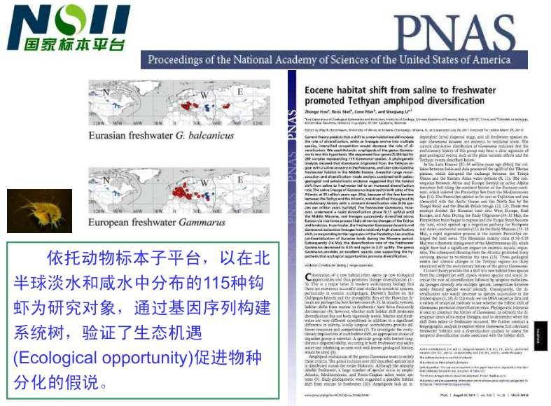
5 Primary Biodiversity Data (The GBIF Network) Biodiversity & Geo-diversity Class: Insecta Order: Lepidoptera Family: Pyralidae Taxonomy Synonym: Pyralis nubilalis Hübner, 1796 DNA Sequence Locus: AAL35331 Definition: acyl-coa Z/E11 desaturase Genus: Ostrinia Hübner, 1825 Vernacular (EN): European Corn-borer Vernacular (DE): Maiszünsler Vernacular (ES): Piral del maíz Vernacular (FR): Pyrale du maïs Family: Gramineae Foodplant: Zea mais L Species: Ostrinia nubilalis (Hübner, 1796) Image 1 mvpyattadg hpekdecfed... Description ( Cultural, Usage.) Diagnosis: Wingspan 26-30mm; sexually dimorphic;male: forewings ochreous to dark brown; female: forewings pale yellow; Literature Pheromones of Ostrinia /pheronet/phlist/ostrinia.html Distribution (Event, History) Collection: DGH Lepidoptera Record id: DGHEUR_ Country: France Coordinates: E N Date: 28 June 2003 Collector: Donald Hobern Climate Average Rainfall Location: N 2.29 E Jan Feb Mar Apr

6 Names Specimen Literature Images Observatory Community Trend: High quality Integration
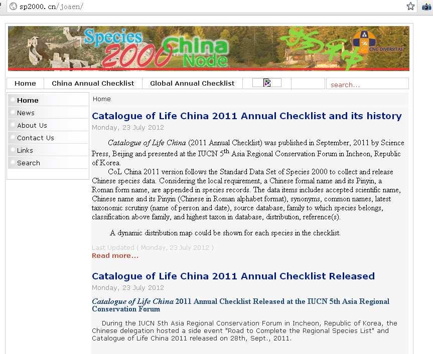
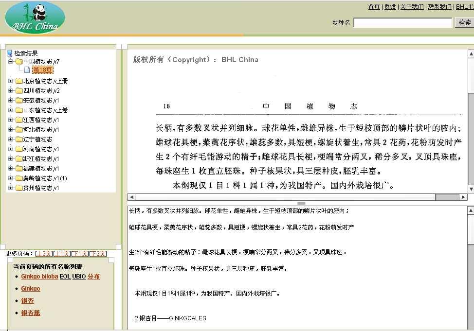
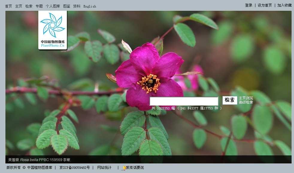
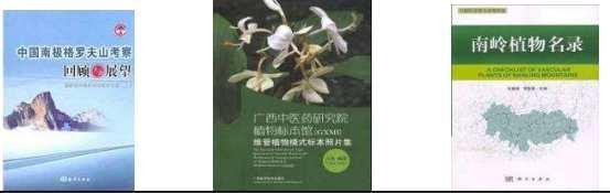
7 Data Status (NSII) Sub-platform Data Types Main Records Plant platform Educational platform Plant specimens, names, books, distributions, authors, Plant specimen, animal specimen, some color photos 3.31 million specimen, 256 volume books, 2.52 million specimen, Animal platform animal specimen, 2.13 million specimen Protected Area platform Mineral & Rock platform Polar Sample platform Other cooperative websites Plant specimen, animal specimen, rocks, fossils, ores, minerals polar biology specimen, ice sample BHL China, Species 2000 China Node, several photo sites, DNA barcode 0.55 million 0.12 million 6,000 > 5 million self building records, 15,000 registered users

8 Plant Platform

9 Animal Platform

10 Educational Platform: Universities

11 Protected Area

12 Mineral & Rock

13 Polar Sample

14 Name Literature Photos Photos
15 Evolution of Data Small -- Big -- Simple & Visualization Scattered - Central - Thematic Static and single - Online and Linkage Managed by small team - By virtual professional team - High-Quality,Feedback, Crowdsourcing Metadata: none - Single Standard - Mashup Storage: ACCESS/EXCEL- MYSQL, SQL SERVER- SOLR - NoSQL
16 Architecture Cache LSID Evaluation High-Quality and the Control

")


17 All-in-one Design: NSII(National Specimen Information Infrastructure) Biodiversity AND Geodiversity >9 million specimens, 100+ institutes & universities NSII Global Regional National Thematic Local Plant Rock Supporting Database Education Animal Protected Area Polar DNA Barcode Literature Distribution Ecology (Habit) User & Communities

18 Service DAAS: Data-As-A-Service SAAS: Software-As-A-Service KAAS: Knowledge-As-A-Service
19 DAAS: Data-As-A-Service Query and download online Submit an application One Type - Multiple Types Data clean by the request Different ways to display data
 Cultural &")
20 DAAS: Data-As-A-Service Description Name Status Distribution Geological Taxon DNA Barcode References Habit (Ecology) Cultural & Usage
21 DAAS: Data-As-A-Service Achievement
22 SAAS: Software-As-A-Service

23 Use Tools and Functions

24 Integrated Species Page
 CBIR: Query and")

25 Multimedia Analysis (When, Where, What) CBIR: Query and Identification (photos) Video Filter, analysis and Notification (Video Frames)

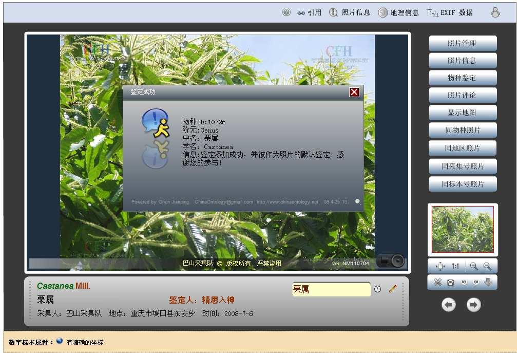
26 Literature data process Internet Archive ABBYY SDK Annotation & Term & Dictionary Hard Copy PDF (b/w) OCRed Text Structured Text User upload Citation Literature Name Status Description Distribution Habit Geological
27 Collection History of Dendrobium (Genus) from


28 Group Query Results on Map


29 Who + When + Where + What visual System
30 Modules of Drupal 7 Boost: cache most of static pages Entity: Flag: add to your favorite Og: groups and interested in some fields Pathauto: friendly to Spider and human Subscriptions: subscribe to even anything Token: User Points: ranks and permissions
31 Group & Permission
32 Subscription


33 Querying from Database VS SOLR Geological Time
34 KAAS: Knowledge-As-A-Service Identification Pilot Project in biodiversity research and informatics
35


36 Image Annotation and Identification Knowledge Base And need more Expert Experience
37 Biodiversity Information Service in China: The Architecture and Techniques Experiences from the Construction of NSII Zheping Keping Ma,Haining Qin,Jinzhong Cui Institute of Botany, Chinese Academy of Sciences TDWG 2012 Conference, Oct. 25, (under developing) NSII(National Specimen Information Infrastructure)
INTEGRATION OF BIODIVERSITY DATABASES IN TAIWAN AND LINKAGE TO GLOBAL DATABASES
 INTEGRATION OF BIODIVERSITY DATABASES IN TAIWAN AND LINKAGE TO GLOBAL DATABASES Kwang-Tsao Shao 1*, Ching-I Peng 1, Eric Yen 2, Kun-Chi Lai 1, Ming-Chih Wang 1, Jack Lin 1, Han Lee 1, Yang Alan 3, and
A FOSS approach to Integrated Water Resource Management: the case study of Red-Thai Binh rivers system in Vietnam
 A FOSS approach to Integrated Water Resource Management: the case study of Red-Thai Binh rivers system in Vietnam Carolina Arias Munoz1, Maria Antonia Brovelli1, Simone Corti1, Marco Micotti2, Rodolfo
the map Redrawing Donald Hobern takes a look at the challenges of managing biodiversity data [ Feature ]
![the map Redrawing Donald Hobern takes a look at the challenges of managing biodiversity data [ Feature ]](/thumbs/82/86628837.jpg "the map Redrawing Donald Hobern takes a look at the challenges of managing biodiversity data [ Feature ]") Redrawing the map Donald Hobern takes a look at the challenges of managing biodiversity data 46 Volume 12 > Number 9 > 2008 www.asiabiotech.com Cicadetta sp., Canberra, Australia, December 2007 Photograph
Redrawing the map Donald Hobern takes a look at the challenges of managing biodiversity data 46 Volume 12 > Number 9 > 2008 www.asiabiotech.com Cicadetta sp., Canberra, Australia, December 2007 Photograph
Discovery and Access of Geospatial Resources using the Geoportal Extension. Marten Hogeweg Geoportal Extension Product Manager
 Discovery and Access of Geospatial Resources using the Geoportal Extension Marten Hogeweg Geoportal Extension Product Manager DISCOVERY AND ACCESS USING THE GEOPORTAL EXTENSION Geospatial Data Is Very
USING GIS CARTOGRAPHIC MODELING TO ANALYSIS SPATIAL DISTRIBUTION OF LANDSLIDE SENSITIVE AREAS IN YANGMINGSHAN NATIONAL PARK, TAIWAN
 CO-145 USING GIS CARTOGRAPHIC MODELING TO ANALYSIS SPATIAL DISTRIBUTION OF LANDSLIDE SENSITIVE AREAS IN YANGMINGSHAN NATIONAL PARK, TAIWAN DING Y.C. Chinese Culture University., TAIPEI, TAIWAN, PROVINCE
ARGUS.net IS THREE SOLUTIONS IN ONE
 OVERVIEW H i g h l y c o n f i g u r a b l e s o f t w a r e a c c o m m o d a t e s a w i d e r a n g e o f c o l l e c t i o n s T h r e e s o l u t i o n s c o v e r P o r t a l s, C o l l e c t i o
Creating an e-flora for South Africa
 SANBI POLICY DOCUMENT DIVISION: Biosystematics Research and Biodiversity Collections EFFECTIVE DATE: 1 April 2014 Compiler: Marianne le Roux & Janine Victor POLICY NUMBER: LAST AMENDED: Creating an e-flora
Management of Geological Information for Mining Sector Development and Investment Attraction Examples from Uganda and Tanzania
 Mineral Wealth Conference 2016 Kampala / Uganda Management of Geological Information for Mining Sector Development and Investment Attraction Examples from Uganda and Tanzania Andreas Barth 1, Andreas Knobloch
Tutorial: Urban Trajectory Visualization. Case Studies. Ye Zhao
 Case Studies Ye Zhao Use Cases We show examples of the web-based visual analytics system TrajAnalytics The case study information and videos are available at http://vis.cs.kent.edu/trajanalytics/ Porto
EuroGEOSS for Drought - Linking the European Drought Observatory to global and local scales
 EuroGEOSS for Drought - Linking the European Drought Observatory to global and local scales Barbara Hofer, Stefan Niemeyer, EC-JRC INSPIRE Conference 2010 Cracow June 24, 2010 Drought Relevance Droughts
UTAH S STATEWIDE GEOGRAPHIC INFORMATION DATABASE
 UTAH S STATEWIDE GEOGRAPHIC INFORMATION DATABASE Data Information and Knowledge Management NASCIO Awards 2009 STATE GEOGRAPHIC INFORMATION DATABASE B. EXECUTIVE SUMMARY Utah has developed one of the most
An Introduction to China and US Map Library. Shuming Bao Spatial Data Center & China Data Center University of Michigan
 An Introduction to China and US Map Library Shuming Bao Spatial Data Center & China Data Center University of Michigan Current Spatial Data Services http://chinadataonline.org China Geo-Explorer http://chinageoexplorer.org
Harvard Center for Geographic Analysis Geospatial on the MOC
 2017 Massachusetts Open Cloud Workshop Boston University Harvard Center for Geographic Analysis Geospatial on the MOC Ben Lewis Harvard Center for Geographic Analysis Aaron Williams MapD Small Team Supporting
GST Geosciences in Space and Time
 A TEAM COLLABORATION TOOL AND PLATFORM TO SHARE 3D GEOMODELS GST Geosciences in Space and Time Paul Gabriel 1,2, Jan Gietzel 1,2, Helmut Schaeben 2 1 GiGa infosystems, Freiberg, Germany 2 Geophysics and
Web GIS Deployment for Administrators. Vanessa Ramirez Solution Engineer, Natural Resources, Esri
 Web GIS Deployment for Administrators Vanessa Ramirez Solution Engineer, Natural Resources, Esri Agenda Web GIS Concepts Web GIS Deployment Patterns Components of an On-Premises Web GIS Federation of Server
What Would John Snow Do (Today)? Part 1
? Part 1") What Would John Snow Do (Today)? Part 1 Tanya Bigos and Derek Law @Tanyabigos @GIS_Bandit Thurs Oct 19 th, 2017 Outline Overview of the ArcGIS Platform Whiteboard discussion Summary Questions A Whole New
What Would John Snow Do (Today)? Part 1 Tanya Bigos and Derek Law @Tanyabigos @GIS_Bandit Thurs Oct 19 th, 2017 Outline Overview of the ArcGIS Platform Whiteboard discussion Summary Questions A Whole New
An intelligent client application for on-line astronomical information
 An intelligent client application for on-line astronomical information Chenzhou CUI Chinese Virtual Observatory Project National Astronomical Observatory of China VO concept Virtual Observatory (VO) is
Dynamic Maps and Historical Context
 Dynamic Maps and Historical Context Jeanette Zerneke International Joint GIS-IDEAS and PNC/ECAI Conference December 2008 Dynamic Maps Roles and Functions of Dynamic Maps in Cultural Collections and Atlases
The Catalogue of Life: towards an integrative taxonomic backbone for biodiversity. Frank A. Bisby, Yuri R. Roskov
 Nimis P. L., Vignes Lebbe R. (eds.) ù Biodiversity: Progress and Problems pp. 37-42. ISBN 978-88-8303-295-0. EUT, 2010. The Catalogue of Life: towards an integrative taxonomic backbone for biodiversity
3D Urban Information Models in making a smart city the i-scope project case study
 UDC: 007:528.9]:004; 007:912]:004; 004.92 DOI: 10.14438/gn.2014.17 Typology: 1.04 Professional Article 3D Urban Information Models in making a smart city the i-scope project case study Dragutin PROTIĆ
Current Status of Chinese Virtual Observatory
 Current Status of Chinese Virtual Observatory Chenzhou Cui, Yongheng Zhao National Astronomical Observatories, Chinese Academy of Science, Beijing 100012, P. R. China Dec. 30, 2002 General Information
Prototyping a Data Sharing System for Flood Forecasting: A Case Study on Sri Lanka
 Prototyping a Data Sharing System for Flood Forecasting: A Case Study on Sri Lanka Masaki Yasukawa 1, Eiji Ikoma 1, Toshihiro Nemoto 1, Mohamed Rasmy 2, Morimasa Tsuda 2, Tomoki Ushiyama 2, Katsunori Tamakawa
What s New. August 2013
 What s New. August 2013 Tom Schwartzman Esri tschwartzman@esri.com Esri UC2013. Technical Workshop. What is new in ArcGIS 10.2 for Server ArcGIS 10.2 for Desktop Major Themes Why should I use ArcGIS 10.2
Town of Taos Request for Proposal Historic Preservation GIS Geodatabase Project April 2007
 Town of Taos Request for Proposal Historic Preservation GIS Geodatabase Project April 2007 1. Background The Town of Taos is requesting proposals from qualified firms or a team of firms who can develop
Annotation tasks and solutions in CLARIN-PL
 Annotation tasks and solutions in CLARIN-PL Marcin Oleksy, Ewa Rudnicka Wrocław University of Technology marcin.oleksy@pwr.edu.pl ewa.rudnicka@pwr.edu.pl CLARIN ERIC Common Language Resources and Technology
GOVERNMENT GIS BUILDING BASED ON THE THEORY OF INFORMATION ARCHITECTURE
 GOVERNMENT GIS BUILDING BASED ON THE THEORY OF INFORMATION ARCHITECTURE Abstract SHI Lihong 1 LI Haiyong 1,2 LIU Jiping 1 LI Bin 1 1 Chinese Academy Surveying and Mapping, Beijing, China, 100039 2 Liaoning
From the Venice Lagoon Atlas towards a collaborative federated system
 From the Venice Lagoon Atlas towards a collaborative federated system City of Venice Alessandro Mulazzani CORILA Consortium for Coordination of Research Activities Concerning the Venice Lagoon System ISMAR-CNR
ArcGIS is Advancing. Both Contributing and Integrating many new Innovations. IoT. Smart Mapping. Smart Devices Advanced Analytics
 ArcGIS is Advancing IoT Smart Devices Advanced Analytics Smart Mapping Real-Time Faster Computing Web Services Crowdsourcing Sensor Networks Both Contributing and Integrating many new Innovations ArcGIS
Geodiversity, Geoheritage & Geoconservation
 Geodiversity, Geoheritage & Geoconservation Geodiversity what is its place within nature diversity? Geodiversity is the variety of nature elements, such as minerals, rocks, fossils, landforms and their
IHP-WINS will make water-related information available online, allowing countries and stakeholders to access reliable data on an open source platform.
 United Nations Educational, Scientific and Cultural Organization International Hydrological Programme International Hydrological Programme Water Information Network System INTERNATIONAL HYDROLOGICAL PROGRAMME
The World Bank and the Open Geospatial Web. Chris Holmes
 The World Bank and the Open Geospatial Web Chris Holmes Geospatial is Everywhere QuickTime and a TIFF (Uncompressed) decompressor are needed to see this picture. Spatial Data Infrastructure (SDI) the sources,
A continuously updated All Genera Index: an achievable goal for Biodiversity Informatics?
 A continuously updated All Genera Index: an achievable goal for Biodiversity Informatics? Tony Rees CSIRO Marine and Atmospheric Research, Australia TDWG Conference, October 2011 Why an All Genera Index?
Geospatial Information for Disease Prevention and Control. INSPIRE Conference 2013
 Geospatial Information for Disease Prevention and Control Dr. Virginia Estevez, Senior Expert GIS Florence, 25 th June 2013 ECDC overview ECDC The European Centre for Disease Prevention and Control (ECDC),
APAN24. Xi an. Digital Silk Road. National Institute of Informatics
 APAN24 Xi an an, e-culture Digital Silk Road K. Ono, A.Kitamoto, M.Onishi, Y.Tanaka National Institute of Informatics 1 Digital Silk Road Project The Digital Silk Road Project extends the UNESCO s s 10-year
The E. I. E. L Project: An Experience of a GIS Development
 The E. I. E. L Project: An Experience of a GIS Development ieves R. Brisaboa José Antonio Cotelo Lema Antonio Fariña Miguel R. Luaces José R.R. Viqueira EC GI & GIS 2003 OVERVIEW 2 Introduction The E.
Challenges and Issues for Regional Geoportal on Disaster Data Sharing - from Perspective of China
 The 3 rd UN-GGIM-AP Plenary Meeting Challenges and Issues for Regional Geoportal on Disaster Data Sharing - from Perspective of China ZHOU Xu, Vice Chair of WG2 National Geomatics Center of China Outline
ArcGIS for INSPIRE. Marten Hogeweg
 ArcGIS for INSPIRE Marten Hogeweg Please Take Our Survey on the App Download the Esri Events app and find your event Select the session you attended Scroll down to find the feedback section Complete answers
Rick Ebert & Joseph Mazzarella For the NED Team. Big Data Task Force NASA, Ames Research Center 2016 September 28-30
 NED Mission: Provide a comprehensive, reliable and easy-to-use synthesis of multi-wavelength data from NASA missions, published catalogs, and the refereed literature, to enhance and enable astrophysical
Economic and Social Council 2 July 2015
 ADVANCE UNEDITED VERSION UNITED NATIONS E/C.20/2015/11/Add.1 Economic and Social Council 2 July 2015 Committee of Experts on Global Geospatial Information Management Fifth session New York, 5-7 August
If you are looking for the ebook by Tobias H. Ppner;Tobias Hoppner Google Earth - NASA World Wind - MS Virtual Earth: Ein Wissenschaftlicher
 Google Earth - NASA World Wind - MS Virtual Earth: Ein Wissenschaftlicher Vergleich Aus Sicht Der Geodasie Und Geoinformatik (German Edition) By Tobias H. Ppner;Tobias Hoppner READ ONLINE If you are looking
Using Big Interagency Databases to Identify Climate Refugia for Idaho s Species of Concern
 Using Big Interagency Databases to Identify Climate Refugia for Idaho s Species of Concern What is a Climate Refugia? habitat that supports a locally reproducing population [or key life history stage]
Environmental Summit: Consolidated view from earth science to biodiversity
 Meeting Host Supporting Partner Meeting Sponsors Environmental Summit: Consolidated view from earth science to biodiversity 105th Technical Committee Palmerston North, New Zealand Josh Lieberman 6 December
SPATIAL INFORMATION GRID AND ITS APPLICATION IN GEOLOGICAL SURVEY
 SPATIAL INFORMATION GRID AND ITS APPLICATION IN GEOLOGICAL SURVEY K. T. He a, b, Y. Tang a, W. X. Yu a a School of Electronic Science and Engineering, National University of Defense Technology, Changsha,
Evaluating e-government : implementing GIS services in Municipality
 Evaluating e-government : implementing GIS services in Municipality Municipality of Thessaloniki - G.I.S. Unit Misirloglou Symeon Head of the GIS Unit ESRI UC - 2016 The GIS Section - subset of the department
Spatial Data Infrastructure Concepts and Components. Douglas Nebert U.S. Federal Geographic Data Committee Secretariat
 Spatial Data Infrastructure Concepts and Components Douglas Nebert U.S. Federal Geographic Data Committee Secretariat August 2009 What is a Spatial Data Infrastructure (SDI)? The SDI provides a basis for
Biomes And Ecosystems Set READ ONLINE
 Biomes And Ecosystems Set READ ONLINE If you are looking for a book Biomes and Ecosystems Set in pdf form, then you have come on to the faithful website. We furnish the complete version of this book in
Uma Singh., Suchit A. John*., JyotiVerma., Shukla B.M and Devranjan and Sudershan Kumar
 OPEN ACCESS at journalijcir.com Research Article ISSN: 2395-5775 HERBARIUM DATA MANAGEMENT SYSTEM (HDMS): SOFTWARE FOR PROVIDING WEB BASED METHODS FOR VALUE ADDITION IN HERBARIUM SPECIMEN Uma Singh., Suchit
National Survey on the Natural Environment of Japan. Hajime Hirosawa Biodiversity Center of Japan Ministry of the Environment (MOE)
") National Survey on the Natural Environment of Japan Hajime Hirosawa Biodiversity Center of Japan Ministry of the Environment (MOE) Biodiversity Center of Japan, MOE Establishment: 1998 Purpose: to encourage
National Survey on the Natural Environment of Japan Hajime Hirosawa Biodiversity Center of Japan Ministry of the Environment (MOE) Biodiversity Center of Japan, MOE Establishment: 1998 Purpose: to encourage
VIRTUAL LIBRARY. EXPLORE like never before
 VIRTUAL LIBRARY EXPLORE like never before National Geographic Magazine Archive 1888-1994 National Geographic magazine is the official journal of the National Geographic Society. Recognised for some of
Amy Driskell. Laboratories of Analytical Biology National Museum of Natural History Smithsonian Institution, Wash. DC
 DNA Barcoding Amy Driskell Laboratories of Analytical Biology National Museum of Natural History Smithsonian Institution, Wash. DC 1 Outline 1. Barcoding in general 2. Uses & Examples 3. Barcoding Bocas
Web GIS Administration: Tips and Tricks
 EdUC 2017 July 8 th, 2017 Web GIS Administration: Tips and Tricks Geri Miller Agenda Concerns Acknowledged User Management Content Management Monitoring Licensing and logins Sophistication of IT support
The Evolutionary Biology Of Plants By Karl J. Niklas READ ONLINE
 The Evolutionary Biology Of Plants By Karl J. Niklas READ ONLINE The Department of Ecology and Evolutionary Biology at Brown University shares a common interest in how including plants, insects and spiders,
世界在线植物志 (World Flora Online) 项目介绍
 项目介绍") Global Strategy for Plant Conservation 世界在线植物志 (World Flora Online) 项目介绍 覃海宁 中国科学院植物研究所 Email: hainingqin@ibcas.ac.cn Website: www.cvh.org.cn #gppc Global Strategy for Plant Conservation A programme of
Global Strategy for Plant Conservation 世界在线植物志 (World Flora Online) 项目介绍 覃海宁 中国科学院植物研究所 Email: hainingqin@ibcas.ac.cn Website: www.cvh.org.cn #gppc Global Strategy for Plant Conservation A programme of
The Geodetic Infrastructure Management Via Web-Based Mapping Technology in Morocco
 The Geodetic Infrastructure Management Via Web-Based Mapping Technology in Morocco Moha EL-AYACHI, Khalid EL HAJARI, Said ALAOUI, and Omar JELLABI, Morocco Key words: infrastructure, web mapping, governance,
Bee common name. Search
 Bee common name Search Bees are flying insects closely related to wasps and ants, known for their role in pollination and, in the case of the best-known bee species, the European honey bee. Managed Website
STATE GEOGRAPHIC INFORMATION DATABASE
 STATE GEOGRAPHIC INFORMATION DATABASE Data Information and Knowledge Management STATE GEOGRAPHIC INFORMATION DATABASE EXECUTIVE SUMMARY Utah has developed one of the most comprehensive statewide GIS resources
FAO GAEZ Data Portal
 FAO GAEZ Data Portal www.fao.org/nr/gaez Renato Cumani Environment Officer Land and Water Division Natural Resources Management and Environment Department Food and Agriculture Organization of the UN October
ArcGIS Enterprise: What s New. Philip Heede Shannon Kalisky Melanie Summers Shreyas Shinde
 ArcGIS Enterprise: What s New Philip Heede Shannon Kalisky Melanie Summers Shreyas Shinde ArcGIS Enterprise is the new name for ArcGIS for Server ArcGIS Enterprise Software Components ArcGIS Server Portal
WMO Guide on Integrated Urban Weather, Environment and Climate Services for Cities (IUWECS) Hong Kong- an experience from a high-density city
 Hong Kong- an experience from a high-density city") WMO Guide on Integrated Urban Weather, Environment and Climate Services for Cities (IUWECS) Hong Kong- an experience from a high-density city Dr. Chao REN Associate Professor School of Architecture The
WMO Guide on Integrated Urban Weather, Environment and Climate Services for Cities (IUWECS) Hong Kong- an experience from a high-density city Dr. Chao REN Associate Professor School of Architecture The
GIS Applications on Environmental Education in Taiwan
 GIS Applications on Environmental Education in Taiwan Track: Education Authors: Yu-Chen Lai, Mei-Ling Yeh, Tien-Yin Chou Abstract GIS is a perfect vehicle to deliver environmental knowledge and spatial
African Coastal Atlas developments. 10 July 2008 EEA Copenhagen, Denmark
 African Coastal Atlas developments 10 July 2008 EEA Copenhagen, Denmark Africa Overview Africa has approximately 40 000 km of coast across 32 mainland countries and four island states. Africa's coastal
The SyMoGIH project and Geo-Larhra: A method and a collaborative platform for a digital historical atlas
 The SyMoGIH project and Geo-Larhra: A method and a collaborative platform for a digital historical atlas Francesco Beretta, Claire-Charlotte Butez To cite this version: Francesco Beretta, Claire-Charlotte
GED 554 IT & GIS. Lecture 6 Exercise 5. May 10, 2013
 GED 554 IT & GIS Lecture 6 Exercise 5 May 10, 2013 Free GIS data sources ******************* Mapping numerical data & Symbolization ******************* Exercise: Making maps for presentation GIS DATA SOFTWARE
ArcGIS Deployment Pattern. Azlina Mahad
 ArcGIS Deployment Pattern Azlina Mahad Agenda Deployment Options Cloud Portal ArcGIS Server Data Publication Mobile System Management Desktop Web Device ArcGIS An Integrated Web GIS Platform Portal Providing
Motivation for project:
 Motivation for project: Shale Gas exploration and development requested of government by Oil Companies. Shale Gas Development Strategic Environment Assessment (SGD SEA) commissioned by DEA Biodiversity
CAVE CLIMATE COMPARISON ACTIVITY BETWEEN THE SURFACE AND THE CAVERN
 CAVE CLIMATE COMPARISON ACTIVITY BETWEEN THE SURFACE AND THE CAVERN Created by Ray Bowers For the Virtual Center for the Environment (VCE) A part of the Institute of Natural Resources Analysis and Management
CHAPTER 7 PRODUCT USE AND AVAILABILITY
 CHAPTER 7 PRODUCT USE AND AVAILABILITY Julie Prior-Magee Photo from SWReGAP Training Site Image Library Recommended Citation Prior-Magee, J.S. 2007. Product use and availability. Chapter 7 in J.S. Prior-Magee,
Geology Merit Badge Workbook
 Merit Badge Workbook This workbook can help you but you still need to read the merit badge pamphlet. This Workbook can help you organize your thoughts as you prepare to meet with your merit badge counselor.
RESOURCES DEVELOPMENT GEOSPATIAL DATA USING THE DIGITAL TOPOGRAPHIC PLAN OF ROMANIA- TOPRO5
 C. C-tin Muşat, F. M. Brebu, A. C. Bălă, I. S. Herban Resources Development Digital Geospatial Data Using the Digital Topographic Plan of Romania - TOPRO5 RESOURCES DEVELOPMENT GEOSPATIAL DATA USING THE
Design and implementation of a new meteorology geographic information system
 Design and implementation of a new meteorology geographic information system WeiJiang Zheng, Bing. Luo, Zhengguang. Hu, Zhongliang. Lv National Meteorological Center, China Meteorological Administration,
Curation of Zoological Collections
 Entomologie II Managing and Curating Museum Collections II: Curation of Zoological Collections Part 1: Entomological Collections [im Rahmen des Workshopprogramms der Goethe Graduate Academy (GRADE), 19.
CENSUS MAPPING WITH GIS IN NAMIBIA. BY Mrs. Ottilie Mwazi Central Bureau of Statistics Tel: October 2007
 CENSUS MAPPING WITH GIS IN NAMIBIA BY Mrs. Ottilie Mwazi Central Bureau of Statistics E-mail: omwazi@npc.gov.na Tel: + 264 61 283 4060 October 2007 Content of Presentation HISTORICAL BACKGROUND OF CENSUS
Connecting Content Information Connections Research SAA Research Forum August
 Connecting Content Information Connections Research SAA Research Forum August 23 2011 Richard T. Fischer, MLS Information Connections Research Intern Connecting Content: Project Background The California
How a Media Organization Tackles the. Challenge Opportunity. Digital Gazetteer Workshop December 8, 2006
 A Case-Study-In-Process: How a Media Organization Tackles the Georeferencing Challenge Opportunity Digital Gazetteer Workshop December 8, 2006 to increase and diffuse geographic knowledge 1888 to 2006:
Institute of Statistical and Geographical Information of Jalisco State Subnational Statistical and Geographical System India.
 Institute of Statistical and Geographical Information of Jalisco State Subnational Statistical and Geographical System India. January 2017 Subnational Statistical and Geographical System National Statistical
ArcGIS for INSPIRE. Marten Hogeweg Satish Sankaran
 ArcGIS for INSPIRE Marten Hogeweg Satish Sankaran Outline What is ArcGIS ArcGIS for INSPIRE Web GIS Case Studies Roadmap Q&A What is INSPIRE? INSPIRE is the legal framework for a European Spatial Data
Lesser Sunda - Banda Seascape Atlas
 Lesser Sunda - Banda Seascape Atlas Report prepared for the development of online interactive map for Lesser Sunda Banda Seascape by WorldFish December 2014 http://sbsatlas.reefbase.org Page 1 of 8 Table
Evaluating Sustainability of the Georesources Observation System
 Evaluating Sustainability of the Georesources Observation System Michael Mente Federal Institute for Geosciences and Natural Resources Germany, Hannover GEOSS-CBC Meeting Athens April 27th 28th, 2009 GEOSS-CBC
Realizing benefits of Spatial Data Infrastructure A user s perspective from Environment Agency - Abu Dhabi
 Realizing benefits of Spatial Data Infrastructure A user s perspective from Environment Agency - Abu Dhabi Anil Kumar Director, Environment Information Management 26 April 2012 Geospatial World Forum,
Nepal (Countries & Cities Of The World) [Import] [Map]
![Nepal (Countries & Cities Of The World) [Import] [Map]](/thumbs/89/98730252.jpg "Nepal (Countries & Cities Of The World) [Import] [Map]") Nepal (Countries & Cities Of The World) [Import] [Map] If you are searched for a book Nepal (Countries & Cities of the World) [Import] [Map] in pdf format, then you've come to faithful site. We furnish
Nepal (Countries & Cities Of The World) [Import] [Map] If you are searched for a book Nepal (Countries & Cities of the World) [Import] [Map] in pdf format, then you've come to faithful site. We furnish
ABCB Net-Indonesia Nanjing, 2-3 November 2015
 Indonesian Biodiversity Information System (IBIS): on going exploring and documenting Dedy Darnaedi & Pesigrihastamadya Research Center For Biology Indonesian Institute of Sciences (LIPI) ABCB Net-Indonesia
Cartographic and Geospatial Futures
 Cartographic and Geospatial Futures 1. Web Cartography, WebGIS, & Virtual Globes--New Roles for Maps, GIS, and GIS professionals 2. Map Mashups, the Neo Neo-geography Movement, & Crowd-sourcing Geospatial
The Development of mygeo-rs: a Knowledge Management System of Geodiversity Data for Tourism Industries
 142 The Development of mygeo-rs: a Knowledge Management System of Geodiversity Data Aziz Deraman, Jamaiah Yahaya, Juhana Salim, Sufian Idris,Dian Indrayani Jambari, Asraf Jaradat Faculty of Information
Rocks And Minerals: A Guide To Familiar Minerals, Gems, Ores And Rocks (Golden Guides) By Herbert Spencer Zim
 By Herbert Spencer Zim") Rocks And Minerals: A Guide To Familiar Minerals, Gems, Ores And Rocks (Golden Guides) By Herbert Spencer Zim Guides & Information; Gemstones & Minerals Glossary A to J This visual guide to gemstones provides
Rocks And Minerals: A Guide To Familiar Minerals, Gems, Ores And Rocks (Golden Guides) By Herbert Spencer Zim Guides & Information; Gemstones & Minerals Glossary A to J This visual guide to gemstones provides
Black Sea Data Access services
 Black Sea Data Access services PERSEUS Oceanographic Mediterranean and Black Sea Data Management Cast Data Base with vertical profiles of physical, chemical and biological data acquired with Bottle casts
Spatial information sharing technology based on Grid
 Spatial information sharing technology based on Grid Hong-bin ZHANG a,b,c,1, Bao-rui CHEN a,b,c,3,gang LI b,c,2, Xiao-ping XIN a,b,c,* a Hulunber Grassland Ecosystem Observation and Research Station, Beijing
Map Collections and the Internet: Some Ideas about Various Online Map Services, Based on the ETH Map Collection in Zürich
 LIBER QUARTERLY, ISSN 1435-5205 LIBER 2000. All rights reserved K.G. Saur, Munich. Printed in Germany Map Collections and the Internet: Some Ideas about Various Online Map Services, Based on the ETH Map
National Remote Sensing Center of China. Space Technology for Sustainable Development in China Status, Achievements and Futures.
 National Remote Sensing Center of China Space Technology for Sustainable Development in China Status, Achievements and Futures Jing Li National Remote Sensing Center of China Ministry of Science and Technology,
Road & Railway Network Density Dataset at 1 km over the Belt and Road and Surround Region
 Journal of Global Change Data & Discovery. 2017, 1(4): 402-407 DOI:10.3974/geodp.2017.04.03 www.geodoi.ac.cn 2017 GCdataPR Global Change Research Data Publishing & Repository Road & Railway Network Density
INSPIRE as a Powerful Tool for Managing and Opening Environmental Data
 INSPIRE as a Powerful Tool for Managing and Opening Environmental Data Leszek Litwin Maria Lenartowicz 1, Alina Litwiak 2, Elżbieta Duraj 2, Łukasz Łukasiewicz 2, Leszek Litwin 2 1 Chief Inspectorate of
CHAPTER 22 GEOGRAPHIC INFORMATION SYSTEMS
 CHAPTER 22 GEOGRAPHIC INFORMATION SYSTEMS PURPOSE: This chapter establishes the administration and use of to improve the quality and accessibility of Department s spatial information and support graphical
ArcGIS Pro: Essential Workflows STUDENT EDITION
 ArcGIS Pro: Essential Workflows STUDENT EDITION Copyright 2018 Esri All rights reserved. Course version 6.0. Version release date August 2018. Printed in the United States of America. The information contained
Application of INSPIRE rules to support environmental impact assessment in IPPC(Integrated Pollution Prevention and Control)
") Direzione Ambiente e Difesa del Suolo e della Costa Application of INSPIRE rules to support environmental impact assessment in IPPC(Integrated Pollution Prevention and Control) Inspire Conference Florence
Direzione Ambiente e Difesa del Suolo e della Costa Application of INSPIRE rules to support environmental impact assessment in IPPC(Integrated Pollution Prevention and Control) Inspire Conference Florence
TheEuropean Location Framework
 TheEuropean Location Framework Presentation to: Author: Date: TN-ITS/INSPIRE session at INSPIRE Conference Olaf Magnus Østensen, ELF co-ordinator 18 June2014 The ELF project 15 national mapping authorities
DOWNLOAD OR READ : ENVIRONMENTAL GEOLOGY MULTIPLE CHOICE QUESTIONS WITH ANSWERS PDF EBOOK EPUB MOBI
 DOWNLOAD OR READ : ENVIRONMENTAL GEOLOGY MULTIPLE CHOICE QUESTIONS WITH ANSWERS PDF EBOOK EPUB MOBI Page 1 Page 2 environmental geology multiple choice questions with answers environmental geology multiple
ArcGIS Pro Q&A Session. NWGIS Conference, October 11, 2017 With John Sharrard, Esri GIS Solutions Engineer
 ArcGIS Pro Q&A Session NWGIS Conference, October 11, 2017 With John Sharrard, Esri GIS Solutions Engineer jsharrard@esri.com ArcGIS Desktop The applications ArcGIS Pro ArcMap ArcCatalog ArcScene ArcGlobe
Introducing the. a partnership of
 Introducing the a partnership of Background Need for online atlas identified by managers and researchers to make coastal data available Shoreline data Ocean and coastal resources Sea-level rise potential
Portal for ArcGIS: An Introduction. Catherine Hynes and Derek Law
 Portal for ArcGIS: An Introduction Catherine Hynes and Derek Law Agenda Web GIS pattern Product overview Installation and deployment Configuration options Security options and groups Portal for ArcGIS
The collaborative working environment an envisaged new level of knowledge transfer and innovative collaboration
 Leibniz-Institut DSMZ-Deutsche Sammlung von Mikroorganismen und Zellkulturen GmbH The collaborative working environment an envisaged new level of knowledge transfer and innovative collaboration Erko Stackebrandt,