FY-3/FY-4 satellite development/ application review and future plan
|
|
|
- Mae Fox
- 6 years ago
- Views:
Transcription

1 The 4 th THORPEX-Asia science workshop&9 th ARC meeting, Oct. 30, 2012 FY-3/FY-4 satellite development/ application review and future plan Tang Shihao tangsh@cma.gov.cn Tel/Fax: National Satellite Meteorological Center, CMA 1
2 Topics 1. Overview of Chinese FengYun Meteorological Satellites Program 2. Introduction of Fengyun polar orbit satellites 3. Introduction of Fengyun geostationary orbit satellites 4. Future Plan


3 Chinese FengYun Meteorological Satellites Program Polar System Geostationary System FY 1A 1B 1C 1D FY 3A 3B 3C 3F First Generation Second Generation First Generation Second Generation FY 2A 2B 2C 2D 2E 2F FY 4A 4B 4C


 CZ-4")


4 LEO Satellites Launch date Satellite phase Life-span Vehicle FY-1A R&D 39days FY-1B R&D 158days FY-1C operation 6.5years(D ecommissi oned) CZ-4 Launched Satellites GEO Satellites FY-1D operation >9years FY-3A R&D In orbit FY-3B R&D In orbit FY-2A R&D 1year FY-2B R&D 3years FY-2C operation >5year FY-2D operation In orbit CZ FY-2E operation In orbit FY-2F operation In orbit


5 Current Satellites In-orbit FY 3A FY 1D FY 3B FY 2D 86.5 FY 2E 105 FY 2F 112 FY 2C 123.5

6 4 +1 Ground Station Distribution Data Efficiency: 12 hours up to 3 hours


7
 of the World Meteorological Organization")
8 The Chinese meteorological satellite program is one of the components of the spacebased Global Observing System (GOS) of the World Meteorological Organization (WMO).
9 Topics 1. Overview of Chinese FengYun Meteorological Satellites Program 2. Introduction of Fengyun polar orbit satellites 3. Introduction of Fengyun geostationary orbit satellites 4. Future Plan


10 FengYun LEO. Satellites: FY 1 Instruments: 10 chl. Visible and Infrared radiometer. Space Environment Monitor Transimission: HRPT: Mbps (DB) GDPT: Mbps No. Status Launch Druation FY-1A Exp. Sept.7, months FY-1B Exp. Sept.3, months FY-1C Op. May 10, 1999 >7 years FY-1D Op. May 15, 2002 >7 years
11 FY 3, the 2nd generation of polar satellites The primary missions of the FY 3are as follows: global sounding of three dimensional thermal and moisture structures of the Earth s atmosphere, measuring cloud properties, and other key parameters, such as precipitation, ozone, etc., to support global numerical weather prediction and environmental services; global imaging of the Earth s surfaces to monitor largescale meteorological and/or hydrological disasters and the biosphere environment; establishing long term environmental datasets with important geophysical parameters for climate monitoring, global prediction, and Earth science research.


12 12


13 ok FY-3 Constellation (FY-3A:Morning,FY-3B:Afternoon) After FY-3A, FY-3B was successfully launched on Nov. 5, 2010 FY-3B was put into use in Apr., instruments on board FY 3A/B, including: VIRR: Visible and Infra Red Radiometer MERSI: Medium Resolution Spectral Imager IRAS: Infrared Atmospheric Sounder MWTS:MicroWave Temperature Sounder MWHS: MicroWave Humidity Sounder MWRI: MicroWave Radiation Imager SBUS: Solar Backscatter Ultraviolet Sounder TOU: Total Ozone mapping Unit SIM: Solar Irritation Monitor ERM: Earth Radiation Monitor SEM: Space Environment Monitor No. Launch Orbit Status FY-3A May 27,2008 M R&D FY-3B Nov 5, 2010 A R&D FY-3C 2013 M Op. FY-3D 2015 A Op. FY-3E 2017(plan) M Op. FY-3G 2019(plan) A Op. FY-3I 2020(plan) M Op. 7

14 FY-3A/B Instruments Specification Abbreviation Instrument Full Name atmospheric sounding Microwave Imaging Optical Imaging from Km to 250m Atmospheric composition: Ozone Radiation budget for earth system VIRR IRAS MWTS MWHS MERSI SBUS TOU MWRI SIM ERM SEM Visible and InfraRed Radiometer InfraRed Atmospheric Sounder MicroWave Temperature Sounder MicroWave Humidity Sounder MEdium Resolution Spectral Imager Solar Backscatter Ultraviolet Sounder Total Ozone Unit Microwave Radiation Imager Solar Irradiation Monitor Earth Radiation Measurement Space Environment Monitor


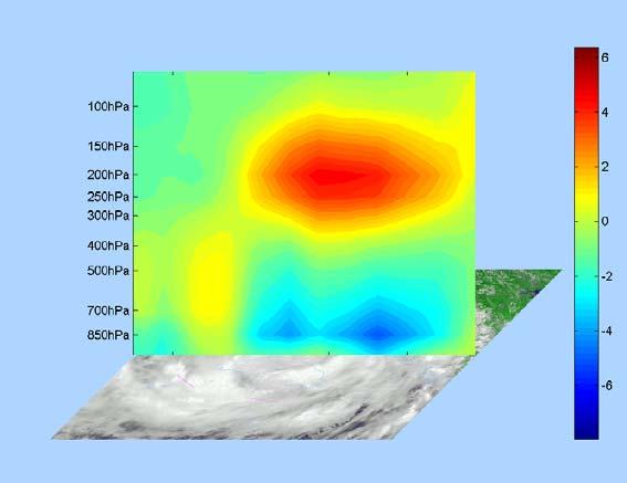
15 风云三号卫星 : 空间分辨率从公里级提高到 250 米 5 公里分辨率 High spatial resolution 15


16 Global coverage


17 3 D vertical Sounding


18 Converage of FY-3A and FY-3B per 6 Hours Converage for NWP Data Assimilation per 6 Hours by 6 Satellites


19 Mesoscale convective clouds monitoring The convective clouds are developing at the edge of the tropical cyclone CARLOS


20 Dust monitoring in the Arabian Peninsula on 26, March 2011 by FY 3A and FY 3B


21 Since Mar. 2011,the bias correction algorithm has been embeded in the operational data processing system of NSMC. FY 3A MWTS 4 MetOp AMSU A Ch. 9


22 Assimilating FY-3A data at ECMWF(Lu Qifeng) After correcting the observing system bias, the standard deviations of first guess departures from four instruments are comparable to the counterparts from MetOp/AQUA. Figure Standard deviations of first guess departures for FY-3A and MetOp-A / Aqua equivalent instruments and channels. Statistics are derived from data for the period from 28 August to 28 September 2008: a) MWTS and AMSU-A; b) MWHS and AMSU-B ; c) IRAS and HIRS ; d) MWRI and AMSR-E.

23 .FY 3 meteorological satellite is set to become an increasingly important component of the global satellite system, supporting NWP centers worldwide,..the date quality for the MWTS instrument is now comparable to that from equivalent US and European meteorological satellites..this represents a significant milestone for the FY 3A programme and cooperation with ECMWF,.the scientific work is well documented in a series of Technical Memoranda available from ECMWF website, and s series of journal articles.
24 Assimilating FY-3A data at ECMWF(Lu Qifeng) When added to a full observing system, the impact of the FY-3A data is neutral to slightly positive. Overall the results are a very promising start to the FY-3 program. Better Worse Figure : Normalised differences in the RMS forecast error between the Full + FY3A experiment and the Full system for the 00Z forecast of 500 hpa and 200 hpa geopotential height for the NH (left) and the SH (right). Verification is against operations for the period is 10 August 1 November 2008 (93 cases), the experiments were run from 20 July to 1 November 2008.


25 100hpa 东亚 500hpa 东亚 500hpa 南半球 Provided by NMC 500hpa 北半球


26 Experiment of FY 3A/TOU total ozone product in numerical model
27 The calibrated and Geolocated FY 3A sensor data are called level one (L1) data, with full resolution that is the same as that of the instrument. It is mainly for numerical prediction model use and further product generation. The atmospheric and geophysics parameters, called level two (L2) data, are derived by using scientific algorithms based on the level one data. These L2 data are used for weather analysis, and environment and nature disaster monitoring. The 10 day, monthly, and yearly mean products are called level three (L3) data, which are mainly for climate analysis. All of the products are constructed in hierarchical data format (HDF) and are easy for users to extract and display.
28 FY-3 Operational and Experimental Products Discipline Measurement FY-3A /B Instruments Atmosphere Cloud/Fog Properties Total Water Vapor Precipitation Aerosol Properties Atmospheric Temperature and Humidity Total Ozone and Ozone Profile MERSI VIRR IRAS MWRI MWHS VIRR MERSI MWRI MWHS MWRI MERSI VIRR IRAS MWTS MWHS 41 TOU SBUS IRAS Land Ocean Cryosphere Land Cover Surface Temperature Vegetation Dynamics Fire and Flood Monitoring Surface Wetness Sea Surface Temperature Sea Surface color Sea Ice Snow Cover VIRR MERSI VIRR VIRR MERSI VIRR MERSI MWRI VIRR MWRI MERSI Radiation Budget Earth s Radiation and Solar Irradiance ERM SIM MERSI VIRR MWRI VIRR MWHS MERSI MWRI Space Environment High Energy Particles Radiation Dose SEM 30
 5 Km, 10 Km global 5%-20% 7 Outgoing")
29 FY 3 Operational Products(part) (Atmospheric and Cloud) (1/4) No. The name of product Resolution km Coverage Accuracy 1 Cloud Mask Lw resolution Granule 5%-20% 2 Cloud Top Temperature 5 km Granule K 3 Cloud Top Height 5 km Granule 50hpa 4 Cloud Optical Thickness 5 Km global 5%-20% 5 Cloud Type 5 Km global 5%-20% 6 Cloud Cover(total amount, high cloud) 5 Km, 10 Km global 5%-20% 7 Outgoing Long-wave Radiation at TOA 5 Km 50Km 17 Km global 3-8 W/ m2 8 Aerosol over Ocean 1Km 10 Km Ocean 15%-30% 9 Fog Detection 1 Km Granule RMS < Total Precipitable Water 1 Km 5 Km 50 Km 27X45 land Ocean 15%-25% 10%-20% Cloud classification

30 FY 3 Operational Products (Atmospheric and Cloud) (2/4) No. The name of product Resolution km Coverage Accuracy 11 Precipitation Rate at the ground 18X30 km global 30% 12 Atmospheric Temperature Profile hPa 13 Humidity Profile hPa 14 Geopotential Height hPa 15 Atmospheric Stability Index 50km global K 50km global 15%-25% 50km global TBD 50km global TBD 16 Total Ozone 50km 17km global 8-15% 17 Ozone Profile 200 Km global 8-15% 18 Flux at at TOA from ERM scaner 35Km Orbit/Regional/ global LW:10Wm -2 SW:30Wm Flux at at TOA from ERM non scaner 120 Orbit LW:10Wm -2 SW:30Wm -2 Precipitable Water from MWRI
 250m,1Km Global 5%-10% 250m,1")

31 FY 3 Operational Products (Land and Sea Surface) (3/4) No. The name of product Resolution Coverage Accuracy 1 Vegetation Index Normalized Differential Vegetation Index 2 Land Cover (Vegetation Type) 250m,1Km Global 5%-10% 250m,1 Km Global 15%-20% 3 Snow Cover 1Km,5Km Global 10%-20% 4 Land Surface Reflectivity 250m,1Km Global TBD 5 Land Surface Temperature 1,25,50X85km Global K 6 Flooding Index 50X85,25 km Global TBD 7 Global Fire Area 1km Global 5% 8 Sea Surface Temperature 1,5,50 Km Global Ocean K 9 Ocean Color/Chlorophyll 1 Km,10 Km Global Ocean 15%-20% 10 Sea-Ice cover 250m,1km Global Ocean 5%-15% Soil Moisture from MWRI Land Surface Temperature from MWRI
32 FY 3 Operational Products (Space Weather) (4/4) No. The name of product Resolution Coverage Accuracy 1 Solar Proton 20km Global 15% 2 Solar Ion 50km 50km Global 20% 3 Solar Electron 50km 50km Global 20% 4 radiant dose 50km 50km Global 20% No. The name of product Resolution Coverage Accuracy 1 Aerosol over land 5 Km,10 Km Global 15%-30% 2 Cloud water total column 18X30 km Global 20%-30% 3 4 Tropical Cyclone Intensity Estimation Wind Vector over Polar region 75km Global 10 hpa 5Km Polar circles TBD 5 Ice Water Paths Index 20km Middle and low Latitude TBD 6 Bidirectional Reflectance Distribution Function 1 Km Global 20% 7 Leaf Area Index 1 Km Global 15%-20% 8 Fraction of Photosynthesis Active Radiation (FPAR) 1 Km Global 15%-20%

33 Retrieval and validation of FY 3A/TOU total column ozone The first BUV type instrument of China, the Total Ozone Unit(TOU) onboard FY 3A polar orbiting satellite was designed to meet the increasing need of better understanding ozone changes. Daily distribution of total ozone column was retrieved from the solar ultraviolet radiation backscattered from Earth and its atmosphere in six discrete bands. Validation was made by comparison with ground based stations of total ozone network.


34 Total Ozone from FY 3/TOU and Validation TOU OMI GOME2 Validation :compared with other remote sensing products and field measurement Low value region over Tibetan Plateau
35 Product validation 北京地区 FY-3/TOU,AURA/OMI,Brewer 仪器臭氧总量观测结果对比 OMI TOU Dobson 日期 FY 3A/TOU,AURA/OMI,Dobson 臭氧总量结果对比 ( 北京地区,2008 年 7 月 16 日 2009 年 1 月 20 日 ) 臭氧总量 (DU)

36 Overlay of FY 3B precipitation product and the corresponding visible image :30 ( 台风 : 启德 )


37 NATURE Here we demonstrate that chemical ozone destruction over the Arctic in early 2011 was for the first time in the observational record comparable to that in the Antarctic ozone hole. Low Ozone Amount Area near North Polar Region 图 年 3 月 26 日北极臭氧总量分布 (FY-3A/TOU) For the first time, sufficient loss occurred to reasonably be describe as an Arctic ozone hole. 图 年 3 月 26 日北极臭氧总量分布 (AURA/OMI)

38 Ozone Profile Total Ozone from ~31 Ozone Profile at 71.11N&77.09 Provided by Hu Fuxiang


39

40 FY-3B/MERSI Arctic Image


 the")

41 Temporal and Spatial Characteristics of the Arctic Ice Cover Fig. Ice Cover Days during June-Nov Fig. continuous ice-cover ratio (Cr) the duration of the ice cover divided by the total period of ice cover


 Pollution")

42 Aerosol and Air quality Monitoring Aerosol Optical Thickness of MERSI 550nm :10(GMT) Pollution source existed in the South west region of Beijing before the Olympic game 42
43 FY-3 polar orbiting satellites Launch schedule FY-3B/PM FY-3C/AM No. Launch Orbit Status FY-3A May 27,2008 M R&D FY-3B Nov 5, 2010 A R&D FY-3C 2013 M Op. FY-3D 2015 A Op. FY-3E 2017(plan) M Op. FY-3G 2019(plan) A Op. FY-3I 2020(plan) M Op. FY-3D/PM FY-3F/ RM FY-3E/AM FY-3G/PM FY-3H/ RM FY-3I/AM Afternoon orbit Morning orbit Low inclination
44 Satellite FY-3C FY-3D FY-3E FY-3G No. Instruments M A M A Schedule MERSI( ) () () () () 2 MWTS() 3 MWHS() 4 MWRI 5 WindRAD 6 HIRAS 7 GAS 8 OMS 9 GNOS 10 ERM( ) () () 11 SIM SEM 12.2 WAI 12.3 IPM 13 IRAS 14 VIRR 15 TOU+SBUS 44
45 Topics 1. Overview of Chinese FengYun Meteorological Satellites Program 2. Introduction of Fengyun polar orbit satellites 3. Introduction of Fengyun geostationary orbit satellites 4. Future Plan
 Data quantities Resolution VIS 0.55~0.")
46 FY 2, the First Generation of GEO Met. Satellites FY 2A/B: 2 Experimental FY 2C/../2H: 6 Operational Payloads:VISSR, SEM VISSR, 5 channels Visible and Infrared Spin Scan Radiometer Specification of 5 channels VISSR Chan. Wavelength (μm) Data quantities Resolution VIS 0.55~ bits 1.25Km IR1 10.3~ bites 5Km IR ~ bites 5Km IR3(WV) 6.3~7.6 8bites 5Km IR4 3.5 ~4.0 10bites 5Km


47 Current Satellites In-orbit FY-2A R&D 1year FY-2B R&D 3years FY-2C operational >5year FY-2D operational In orbit CZ FY-2E operational In orbit FY-2F operational In orbit FY 3A FY 1D FY 3B FY 2D 86.5 FY 2E 105 FY 2F 112 FY 2C 123.5


48

49 风云二号 F 星和 E 星对比


50 杜苏芮 台风监测
 降水估计动画 (6")
51 台风 启德 降水估计产品 2012 年 8 月 16 日 14:36 16:42( 北京时 ) 降水估计动画 (6 分钟间隔 )

52 FY-2D B: 86.5ºE FY-2E A: 105ºE Mode 1: Routine Mode Mode 2: Flood season Mode Sat. Imager Observation time services Sat. Imager Observation time Services FY-2C S- VISSR FY-2D S- VISSR xx:00 min xx:30 min Routine Routine FY- 2C FY- 2D S- VISSR S- VISSR xx:00 min xx:30 min xx:15 min xx:45 min JUN.1 AUG.31 JUN.1 AUG.31


53 风云二号双星观测使云图观测时间密度提高 4 倍! 间隔 1 小时间隔 30 分钟双星间隔 15 分钟 53
 1K ±1 k(220k) ~3K(<220K) 样本统计平均结果 DTBB / K DTBB / K DTBB / K 8 6 4 IR01-2 02 OPERATION -4-6 GSICS -8")

54 Calibration TBB Bias with IASI 分别用业务和 GSICS 定标系数计算 FY2 亮温, 考察其与相应匹配点处 IASI 观测值间的亮温差异 0.5K±0.5k(290K) 1K ±1 k(220k) ~3K(<220K) 样本统计平均结果 DTBB / K DTBB / K DTBB / K IR OPERATION -4-6 GSICS TBB / K IR TBB / K 图中星号为对应温度处的平均偏差,Bar 代表的是两倍标准差 IR TBB / K 2011 年 FY2E 定标亮温偏差 DTBB 随温度分布图图中星号为对应温度处的平均偏差,Bar 代表的是两倍标准差


55 21 FY2E-GSICS-9:45 21 FY2E-OPERATION 偏低 MODIS-9: K~200K
56 22 FY2E-GSICS-7:00 22 FY2E-OPERATION 偏高 MODIS-6: 台风 (18.9N,93.0E)
57 FY 2 Operational Products No. Products No. Products No. Products 1 Raw image 10 OLR 19 ISCCP dataset 2 Normalized image 11 SST 20 Heavy fog monitor 3 Projected image 12 TBB 21 Sea ice monitor 4 Mosaic image 13 Upper troposphere humidity 22 Typhoon location 5 Cloud classification 14 Cloud water profile 23 Fire spots 6 Total cloud amount 15 Precipitable water 24 Water bodies 7 AMV 16 Solar irradiance 25 Soil humidity 8 Rainfall estimation 17 Sand storm detection 9 Precipitation index 18 Snow cover
 FY-4 Prototype S/C & Payload")
58 FY-4: China s next generation of geostationary meteorological satellite Four main payloads Interferometric Infrared Sounder Advanced Radiation Imager Lightning Mapping Imager Solar X-EUV imaging telescope (Not loaded in 1 st satellite) FY-4 Prototype S/C & Payload Configuration
59 Topics 1. Overview of Chinese FengYun Meteorological Satellites Program 2. Introduction of Fengyun polar orbit satellites 3. Introduction of Fengyun geostationary orbit satellites 4. Future Plan
 2020) 2015FY 3D")
 2016FY 2G 2017FY 3E 2014FY")

60 Launch plan for Future FY Series( ) 2020) 2015FY 3D 2015FY 4A (TEST) 2015FY 3RM1 (TEST) 2016FY 2G 2017FY 3E 2014FY 2G 2013FY 3C 2012FY 2F 2017FY 4B 2019FY 3F 2020FY 3G 2019FY 4C 2019FY 3RM2 60
Brief introduction to. National Satellite Meteorological Center, CMA. Jinsong Wang Deputy Director-General NSMC/CMA
 Brief introduction to National Satellite Meteorological Center, CMA Jinsong Wang Deputy Director-General NSMC/CMA Rio de Janerio, Oct. 12-15, 10 Beijing Guangzhou Urumuqi Jiamusi 2 NSMC DPC@NSMC KIRUNA
Progress on CMA s Meteorological Satellites
 CMA report on ET SAT 6, Geneva, April 12 16, 11 Progress on CMA s Meteorological Satellites YANG Jun Director General, National Satellite Meteorological Center, CMA 1 FENGYUN satellite programs Current
The Status Report of FY-2F
 Seventh Session of the Expert Team on Satellite Utilization and Products The Status Report of FY-2F Presented by Xiang Fang National Satellite Meteorological Center (NSMC) China Meteorological Administration
CMA Consideration on early-morning orbit satellite
 CMA Consideration on early-morning orbit satellite National Satellite Meteorological Center,CMA Yang Jun CGMS 40 in Lugano, 5-9 Nov., 2012 Outline Background Gap analysis on the sounding data coverage
The current status of FY-3D
 The current status of FY-3D Xiang Fang National Satellite Meteorological Center, China Meteorological Administration (NSMC/CMA) OUTLINE Overview Key instruments onboard FY-3D Products and data service
Status report on the current and future satellite systems by CMA. Presented to CGMS46-CMA-WP-01, Plenary session, agenda item D.1
 Status report on the current and future satellite systems by CMA Presented to CGMS46-CMA-WP-01, Plenary session, agenda item D.1 Overview - Planning of CMA satellite systems FengYun Meteorological Satellites
The current status of FY-3D. (Submitted by Xiang Fang, CMA) Summary and Purpose of Document
 Summary and Purpose of Document") WORLD METEOROLOGICAL ORGANIZATION COMMISSION FOR BASIC SYSTEMS OPEN PROGRAMME AREA GROUP ON INTEGRATED OBSERVING SYSTEMS INTER-PROGRAMME EXPERT TEAM ON SATELLITE UTILIZATION AND PRODUCTS FOURTH SESSION
WORLD METEOROLOGICAL ORGANIZATION COMMISSION FOR BASIC SYSTEMS OPEN PROGRAMME AREA GROUP ON INTEGRATED OBSERVING SYSTEMS INTER-PROGRAMME EXPERT TEAM ON SATELLITE UTILIZATION AND PRODUCTS FOURTH SESSION
CMA Satellite Programs Supporting SWCEM
 CMA Satellite Programs Supporting SWCEM YANG Jun National Satellite Meteorological Center, CMA Operational Space-based Weather and Climate Extremes Monitoring (SWCEM) Workshop 15-17,Feb., 2017, Geneva,
Development of Tropical cyclone objective analysis technique based on FY serial satellite data
 2 nd International Workshop On Satellite Analysis of Tropical Cyclones (IWSATC-2) Update on Objective Satellite-Based TC Analysis Methods 18 February 2016 Honolulu, Hawaii, USA Development of Tropical
Updates on CMA FENGYUN Meteorological Satellite Programs
 Updates on CMA FENGYUN Meteorological Satellite Programs Peng ZHANG National Satellite Meteorological Center, China Meteorological Administration (NSMC/CMA) 29 Nov. - 5 Dec. 2017, Darmstadt, Germany 1.
Preparation for FY-4A. (Submitted by Xiang Fang, CMA)
") WORLD METEOROLOGICAL ORGANIZATION COMMISSION FOR BASIC SYSTEMS OPEN PROGRAMME AREA GROUP ON INTEGRATED OBSERVING SYSTEMS EXPERT TEAM ON SATELLITE UTILIZATION AND PRODUCTS ET-SUP-8/Doc. 10.3 (2.IV.2014)
WORLD METEOROLOGICAL ORGANIZATION COMMISSION FOR BASIC SYSTEMS OPEN PROGRAMME AREA GROUP ON INTEGRATED OBSERVING SYSTEMS EXPERT TEAM ON SATELLITE UTILIZATION AND PRODUCTS ET-SUP-8/Doc. 10.3 (2.IV.2014)
An Introduction of FY3 Satellite Project ---Status and Future Plan
 7 th GPM workshop An Introduction of FY3 Satellite Project ---Status and Future Plan National Satellite Meteorological Center, CMA Hu Yang Naimeng Lu Dec 04,2007 7 th GPM workshop Contents 1.Introduction
Status report on the current and future meteorological satellite systems by CMA
 Status report on the current and future meteorological satellite systems by CMA Presented to CGMS-44Plenary session, agenda item [D.1] Overview - Planning of China satellite systems by year 2025 NSIP:
Training on FY 3 product suite
 Training on FY 3 product suite Xiang Fang National Satellite Meteorological Center,CMA Outline Status of FY 3 satellite Training Actions Training Plan Status of FY 3 satellite Currently On Orbit Satellites:
Xiang FNAG National Satellite Meteorological Center, China Meteorological Administration (NSMC/CMA)
") CMA Fengyun Meteorological Satellite Program Xiang FNAG National Satellite Meteorological Center, China Meteorological Administration (NSMC/CMA) Outline Overview Current Missions Latest Progress Future
CMA Fengyun Meteorological Satellite Program Xiang FNAG National Satellite Meteorological Center, China Meteorological Administration (NSMC/CMA) Outline Overview Current Missions Latest Progress Future
Updates on Chinese Meteorological Satellite Programs
 6 th Asia/Oceania Meteorological Satellite Users Conference Updates on Chinese Meteorological Satellite Programs Caiying Wei Deputy director-general of NSMC National Satellite Meteorological Center (NSMC)
Evaluation of FY-3B data and an assessment of passband shifts in AMSU-A and MSU during the period
 Interim report of Visiting Scientist mission NWP_11_05 Document NWPSAF-EC-VS-023 Version 0.1 28 March 2012 Evaluation of FY-3B data and an assessment of passband Qifeng Lu 1 and William Bell 2 1. China
Interpretation of Polar-orbiting Satellite Observations. Atmospheric Instrumentation
 Interpretation of Polar-orbiting Satellite Observations Outline Polar-Orbiting Observations: Review of Polar-Orbiting Satellite Systems Overview of Currently Active Satellites / Sensors Overview of Sensor
Instrumentation planned for MetOp-SG
 Instrumentation planned for MetOp-SG Bill Bell Satellite Radiance Assimilation Group Met Office Crown copyright Met Office Outline Background - the MetOp-SG programme The MetOp-SG instruments Summary Acknowledgements:
MONITORING WEATHER AND CLIMATE FROM SPACE
 MONITORING WEATHER AND CLIMATE FROM SPACE EUMETSAT Report on New Services Anders Meier Soerensen New X/L-band antenna, Greenland Athens: New 3.0 m L/X-band antenna New 2.4 m L/Xband antenna Installations
Joint Polar Satellite System. 3 rd Post-EPS User Consultation Workshop Mike Haas
 3 rd Post-EPS User Consultation Workshop Mike Haas Overview Introduction - Policy Drivers - Management System Description - Space Segment - Ground Segment Partnerships Status Benefits 2 Introduction (Policy
A new operational medium-range numerical weather forecast system of CHINA. NWPD/NMC/CMA (Beijing,CHINA)
") A new operational medium-range numerical weather forecast system of CHINA NWPD/NMC/CMA (Beijing,CHINA) Organizational Chart of CMA NSMC (National Satellite Meteorological Center) NCC (National Climate
A new operational medium-range numerical weather forecast system of CHINA NWPD/NMC/CMA (Beijing,CHINA) Organizational Chart of CMA NSMC (National Satellite Meteorological Center) NCC (National Climate
REVISION OF THE STATEMENT OF GUIDANCE FOR GLOBAL NUMERICAL WEATHER PREDICTION. (Submitted by Dr. J. Eyre)
") WORLD METEOROLOGICAL ORGANIZATION Distr.: RESTRICTED CBS/OPAG-IOS (ODRRGOS-5)/Doc.5, Add.5 (11.VI.2002) COMMISSION FOR BASIC SYSTEMS OPEN PROGRAMME AREA GROUP ON INTEGRATED OBSERVING SYSTEMS ITEM: 4 EXPERT
WORLD METEOROLOGICAL ORGANIZATION Distr.: RESTRICTED CBS/OPAG-IOS (ODRRGOS-5)/Doc.5, Add.5 (11.VI.2002) COMMISSION FOR BASIC SYSTEMS OPEN PROGRAMME AREA GROUP ON INTEGRATED OBSERVING SYSTEMS ITEM: 4 EXPERT
McIDAS support of Suomi-NPP /JPSS and GOES-R L2
 McIDAS support of Suomi-NPP /JPSS and GOES-R L2 William Straka III 1 Tommy Jasmin 1, Bob Carp 1 1 Cooperative Institute for Meteorological Satellite Studies, Space Science and Engineering Center, University
Xinhua Liu National Meteorological Center (NMC) of China Meteorological Administration (CMA)
 of China Meteorological Administration (CMA)") The short-time forecasting and nowcasting technology of severe convective weather for aviation meteorological services in China Xinhua Liu National Meteorological Center (NMC) of China Meteorological Administration
The short-time forecasting and nowcasting technology of severe convective weather for aviation meteorological services in China Xinhua Liu National Meteorological Center (NMC) of China Meteorological Administration
Techniques of Severe Convective Weather Comprehensive Monitoring
 Techniques of Severe Convective Weather Comprehensive Monitoring Yongguang Zheng, Lin Yinjing, Zhu Wenjian, Lan Yu, Tang Wenyuan, Zhang Xiaoling, Mao Dongyan, Zhou Qingliang, Zhang Zhigang Severe Weather
Modeling effects of changes in diffuse radiation on light use efficiency in forest ecosystem. Wei Nan
 Modeling effects of changes in diffuse radiation on light use efficiency in forest ecosystem Wei Nan 2018.05.04 1 Outline 1. Background 2. Material and methods 3. Results & Discussion 4. Conclusion 2 1
CGMS Baseline. Sustained contributions to the Global Observing System. Endorsed by CGMS-46 in Bengaluru, June 2018
 CGMS Baseline Sustained contributions to the Global Observing System Best Practices for Achieving User Readiness for New Meteorological Satellites Endorsed by CGMS-46 in Bengaluru, June 2018 CGMS/DOC/18/1028862,
GSICS in CMA. Peng ZHANG, Xiuqing Hu, Ling Sun, Lin Chen, Na Xu, Yuan Li, Chengli Qi, Qiang Guo etc
 GSICS in CMA Peng ZHANG, Xiuqing Hu, Ling Sun, Lin Chen, Na Xu, Yuan Li, Chengli Qi, Qiang Guo etc National Satellite Meteorological Center, CMA July 15-16, Tokyo, Japan Outline GSICS history in CMA Current
An Evaluation of FY-3C MWHS-2 and its potential to improve forecast accuracy at ECMWF
 An Evaluation of FY-3C MWHS-2 and its potential to improve forecast accuracy at ECMWF Heather Lawrence, final-year EUMETSAT fellow, ECMWF Supervised by: Niels Bormann & Stephen English Slide 1 China s
OBSERVING SYSTEM EXPERIMENTS ON ATOVS ORBIT CONSTELLATIONS
 OBSERVING SYSTEM EXPERIMENTS ON ATOVS ORBIT CONSTELLATIONS Enza Di Tomaso and Niels Bormann European Centre for Medium-range Weather Forecasts Shinfield Park, Reading, RG2 9AX, United Kingdom Abstract
Update on SCOPE-Nowcasting Pilot Project 1
 Update on SCOPE-Nowcasting Pilot Project 1 Xiang Fang National Satellite Meteorological Center (NSMC) China Meteorological Administration (CMA) Overview Now, China has 6 meteorological satellites in operation.
CGMS Baseline In response to CGMS action/recommendation A45.01 HLPP reference: 1.1.8
 Prepared by WGIII Agenda Item: 7.1 Discussed in WGIII CGMS Baseline In response to CGMS action/recommendation A45.01 HLPP reference: 1.1.8 In CGMS-45, Working Group III agreed to hold a review of the CGMS
Evaluation of Satellite and Reanalysis Products of Downward Surface Solar Radiation over East Asia
 International Workshop on Land Use/Cover Changes and Air Pollution in Asia August 4-7th, 2015, Bogor, Indonesia Evaluation of Satellite and Reanalysis Products of Downward Surface Solar Radiation over
Update on SCOPE-Nowcasting Pilot Project Real Time Ocean Products Suman Goyal Scientist-E
 Update on SCOPE-Nowcasting Pilot Project Real Time Ocean Products Suman Goyal Scientist-E 19-22 Nov 2013 SCOPE-Nowcasting-1 Agenda Item 5 Pilot Projects Overview Users /Clients User requirements Product
Status of Indian Satellite Meteorological Programme
 Status of Indian Satellite Meteorological Programme Pradeep K Thapliyal Space Applications Centre (SAC) Indian Space research Organisation (ISRO) Ahmedabad (INDIA) Email: pkthapliyal@sac.isro.gov.in International
The use and impacts of sea surface temperature from passive microwave measurements
 The use and impacts of sea surface temperature from passive microwave measurements Anne O Carroll 6/12/2017 ECMWF workshop on using low frequency passive microwave measurements in research and operational
Jun Park National Meteorological Satellite Center Korea Meteorological Administration
 KMA Implementation Plan for Satellite Climate products Jun Park National Meteorological Satellite Center Korea Meteorological Administration jun.park@kma.go.kr Outline 1. Introduction : Current & Future
Lecture 4b: Meteorological Satellites and Instruments. Acknowledgement: Dr. S. Kidder at Colorado State Univ.
 Lecture 4b: Meteorological Satellites and Instruments Acknowledgement: Dr. S. Kidder at Colorado State Univ. US Geostationary satellites - GOES (Geostationary Operational Environmental Satellites) US
Improving Surface-based Data Quality through Improved Standardization of Practice and Procedures In Situ Observation Experience & Regional Needs
 Improving Surface-based Data Quality through Improved Standardization of Practice and Procedures In Situ Observation Experience & Regional Needs Dr. Li Bai China Meteorological Administration Dec.2014
A New Era: Three-Dimensional Observation and Service with Fully High Resolutions on FY-4 Platform are Coming Next Year
 6 th Asia/Oceania Meteorological Satellite Users Conference A New Era: Three-Dimensional Observation and Service with Fully High Resolutions on FY-4 Platform are Coming Next Year Presented by Qiang Guo
Recent Progress of Fengyun Meteorology Satellites
 Recent Progress of Fengyun Meteorology Satellites ZHANG Peng, CHEN Lin, XIAN di, XU Zhe (National Satellite Meteorological Center/National Center for Space Weather, China Meteorological Administration,
EUMETSAT STATUS AND PLANS
 1 EUM/TSS/VWG/15/826793 07/10/2015 EUMETSAT STATUS AND PLANS François Montagner, Marine Applications Manager, EUMETSAT WMO Polar Space Task Group 5 5-7 October 2015, DLR, Oberpfaffenhofen PSTG Strategic
Use of FY-3C/GNOS Data for Assessing the on-orbit Performance of Microwave Sounding Instruments
 Use of FY-3C/GNOS Data for Assessing the on-orbit Performance of Microwave Sounding Instruments Xiuqing Hu 1 Xueyan Hou 2, and Mi Liao 1 1 National Satellite Meteorological Center (NSMC), CMA 2 Chinese
H-SAF future developments on Convective Precipitation Retrieval
 H-SAF future developments on Convective Precipitation Retrieval Francesco Zauli 1, Daniele Biron 1, Davide Melfi 1, Antonio Vocino 1, Massimiliano Sist 2, Michele De Rosa 2, Matteo Picchiani 2, De Leonibus
2012 Typhoon Activity Prediction
 2012 Typhoon Activity Prediction Published by Shanghai Typhoon Institute of China Meteorological Administration 4 May 2012 Prediction of 2012 Northwest Pacific Basin and South China Sea Tropical Cyclone
GCOM-W1 now on the A-Train
 GCOM-W1 now on the A-Train GCOM-W1 Global Change Observation Mission-Water Taikan Oki, K. Imaoka, and M. Kachi JAXA/EORC (& IIS/The University of Tokyo) Mini-Workshop on A-Train Science, March 8 th, 2013
Feature-tracked 3D Winds from Satellite Sounders: Derivation and Impact in Global Models
 Feature-tracked 3D Winds from Satellite Sounders: Derivation and Impact in Global Models David Santek 1, A.-S. Daloz 1, S. Tushaus 1, M. Rogal 1, W. McCarty 2 1 Space Science and Engineering Center/University
VALIDATION OF INSAT-3D DERIVED RAINFALL. (Submitted by Suman Goyal, IMD) Summary and Purpose of Document
 Summary and Purpose of Document") WORLD METEOROLOGICAL ORGANIZATION COMMISSION FOR BASIC SYSTEMS OPEN PROGRAMME AREA GROUP ON INTEGRATED OBSERVING SYSTEMS INTER-PROGRAMME EXPERT TEAM ON SATELLITE UTILIZATION AND PRODUCTS SECOND SESSION
WORLD METEOROLOGICAL ORGANIZATION COMMISSION FOR BASIC SYSTEMS OPEN PROGRAMME AREA GROUP ON INTEGRATED OBSERVING SYSTEMS INTER-PROGRAMME EXPERT TEAM ON SATELLITE UTILIZATION AND PRODUCTS SECOND SESSION
Satellite observation of atmospheric dust
 Satellite observation of atmospheric dust Taichu Y. Tanaka Meteorological Research Institute, Japan Meteorological Agency 11 April 2017, SDS WAS: Dust observation and modeling @WMO, Geneva Dust observations
1. Space-based constraints on non-methane VOC emissions in Asia
 1. Space-based constraints on non-methane VOC emissions in Asia + 2. Sensitivity of summertime surface ozone to surface temperature over Southeastern U.S.: Interannual variability as a diagnostic for chemical
ASSIMILATION EXPERIMENTS WITH DATA FROM THREE CONICALLY SCANNING MICROWAVE INSTRUMENTS (SSMIS, AMSR-E, TMI) IN THE ECMWF SYSTEM
 IN THE ECMWF SYSTEM") ASSIMILATION EXPERIMENTS WITH DATA FROM THREE CONICALLY SCANNING MICROWAVE INSTRUMENTS (SSMIS, AMSR-E, TMI) IN THE ECMWF SYSTEM Niels Bormann 1, Graeme Kelly 1, Peter Bauer 1, and Bill Bell 2 1 ECMWF,
ASSIMILATION EXPERIMENTS WITH DATA FROM THREE CONICALLY SCANNING MICROWAVE INSTRUMENTS (SSMIS, AMSR-E, TMI) IN THE ECMWF SYSTEM Niels Bormann 1, Graeme Kelly 1, Peter Bauer 1, and Bill Bell 2 1 ECMWF,
EUMETSAT PLANS. Dr. K. Dieter Klaes EUMETSAT Am Kavalleriesand 31 D Darmstadt Germany
 EUMETSAT PLANS Dr. K. Dieter Klaes EUMETSAT Am Kavalleriesand 31 D-64295 Darmstadt Germany Page 1 EUMETSAT SATELLITE PROGRAMMES 96 97 98 99 00 01 02 03 04 05 06 07 08 09 10 11 12 13 14 15 16 17 18 METEOSAT
NEW CGMS BASELINE FOR THE SPACE-BASED GOS. (Submitted by the WMO Secretariat) Summary and Purpose of Document
 Summary and Purpose of Document") WORLD METEOROLOGICAL ORGANIZATION COMMISSION FOR BASIC SYSTEMS OPEN PROGRAMME AREA GROUP ON INTEGRATED OBSERVING SYSTEMS EXPERT TEAM ON SATELLITE SYSTEMS ET-SAT-7/Inf. 2 (12.III.2012) ITEM: 8.1 SEVENTH
WORLD METEOROLOGICAL ORGANIZATION COMMISSION FOR BASIC SYSTEMS OPEN PROGRAMME AREA GROUP ON INTEGRATED OBSERVING SYSTEMS EXPERT TEAM ON SATELLITE SYSTEMS ET-SAT-7/Inf. 2 (12.III.2012) ITEM: 8.1 SEVENTH
Future Opportunities of Using Microwave Data from Small Satellites for Monitoring and Predicting Severe Storms
 Future Opportunities of Using Microwave Data from Small Satellites for Monitoring and Predicting Severe Storms Fuzhong Weng Environmental Model and Data Optima Inc., Laurel, MD 21 st International TOV
Some NOAA Products that Address PSTG Satellite Observing Requirements. Jeff Key NOAA/NESDIS Madison, Wisconsin USA
 Some NOAA Products that Address PSTG Satellite Observing Requirements Jeff Key NOAA/NESDIS Madison, Wisconsin USA WMO Polar Space Task Group, 4 th meeting, Greenbelt, 30 September 2014 Relevant Missions
APPENDIX 2 OVERVIEW OF THE GLOBAL PRECIPITATION MEASUREMENT (GPM) AND THE TROPICAL RAINFALL MEASURING MISSION (TRMM) 2-1
 AND THE TROPICAL RAINFALL MEASURING MISSION (TRMM) 2-1") APPENDIX 2 OVERVIEW OF THE GLOBAL PRECIPITATION MEASUREMENT (GPM) AND THE TROPICAL RAINFALL MEASURING MISSION (TRMM) 2-1 1. Introduction Precipitation is one of most important environmental parameters.
APPENDIX 2 OVERVIEW OF THE GLOBAL PRECIPITATION MEASUREMENT (GPM) AND THE TROPICAL RAINFALL MEASURING MISSION (TRMM) 2-1 1. Introduction Precipitation is one of most important environmental parameters.
2011 Typhoon Activity Prediction
 2011 Typhoon Activity Prediction Published by Shanghai Typhoon Institute of China Meteorological Administration April 21th, 2011 Prediction of 2011 Northwest Pacific Basin and South China Sea Tropical
STATUS OF JAPANESE METEOROLOGICAL SATELLITES AND RECENT ACTIVITIES OF MSC
 STATUS OF JAPANESE METEOROLOGICAL SATELLITES AND RECENT ACTIVITIES OF MSC Daisaku Uesawa Meteorological Satellite Center, Japan Meteorological Agency Abstract MTSAT-1R is the current operational Japanese
Extending the use of surface-sensitive microwave channels in the ECMWF system
 Extending the use of surface-sensitive microwave channels in the ECMWF system Enza Di Tomaso and Niels Bormann European Centre for Medium-range Weather Forecasts Shinfield Park, Reading, RG2 9AX, United
Japanese Programs on Space and Water Applications
 Japanese Programs on Space and Water Applications Tamotsu IGARASHI Remote Sensing Technology Center of Japan June 2006 COPUOS 2006 Vienna International Centre Water-related hazards/disasters may occur
HY-2A Satellite User s Guide
 National Satellite Ocean Application Service 2013-5-16 Document Change Record Revision Date Changed Pages/Paragraphs Edit Description i Contents 1 Introduction to HY-2 Satellite... 1 2 HY-2 satellite data
EUMETSAT SAF NETWORK. Lothar Schüller, EUMETSAT SAF Network Manager
 1 EUMETSAT SAF NETWORK Lothar Schüller, EUMETSAT SAF Network Manager EUMETSAT ground segment overview METEOSAT JASON-2 INITIAL JOINT POLAR SYSTEM METOP NOAA SATELLITES CONTROL AND DATA ACQUISITION FLIGHT
CORRELATION BETWEEN ATMOSPHERIC COMPOSITION AND VERTICAL STRUCTURE AS MEASURED BY THREE GENERATIONS OF HYPERSPECTRAL SOUNDERS IN SPACE
 CORRELATION BETWEEN ATMOSPHERIC COMPOSITION AND VERTICAL STRUCTURE AS MEASURED BY THREE GENERATIONS OF HYPERSPECTRAL SOUNDERS IN SPACE Nadia Smith 1, Elisabeth Weisz 1, and Allen Huang 1 1 Space Science
F O U N D A T I O N A L C O U R S E
 F O U N D A T I O N A L C O U R S E December 6, 2018 Satellite Foundational Course for JPSS (SatFC-J) F O U N D A T I O N A L C O U R S E Introduction to Microwave Remote Sensing (with a focus on passive
MSG system over view
 MSG system over view 1 Introduction METEOSAT SECOND GENERATION Overview 2 MSG Missions and Services 3 The SEVIRI Instrument 4 The MSG Ground Segment 5 SAF Network 6 Conclusions METEOSAT SECOND GENERATION
Monitoring Air Pollution from Space
 Monitoring Air Pollution from Space Media Regional Training Workshop 16 th Nov 20 th Nov 2015 Shreta Ghimire International Centre for Integrated Mountain Development Kathmandu, Nepal Why do we study air
The Earth Explorer Missions - Current Status
 EOQ N 66 July 2000 meteorology earthnet remote sensing solid earth future programmes Earth Observation Quarterly The Earth Explorer Missions - Current Status G. Mégie (1) and C.J. Readings (2) (1) Institut
Next generation of EUMETSAT microwave imagers and sounders: new opportunities for cloud and precipitation retrieval
 Next generation of EUMETSAT microwave imagers and sounders: new opportunities for cloud and precipitation retrieval Christophe Accadia, Sabatino Di Michele, Vinia Mattioli, Jörg Ackermann, Sreerekha Thonipparambil,
通量数据质量控制的理论与方法 理加联合科技有限公司
 通量数据质量控制的理论与方法 理加联合科技有限公司 通量变量 Rn = LE + H + G (W m -2 s -1 ) 净辐射 潜热 感热 地表热 通量 通量 通量 通量 Fc (mg m -2 s -1 ) 二氧化碳通量 τ [(kg m s -1 ) m -2 s -1 ] 动量通量 质量控制 1. 概率统计方法 2. 趋势法 3. 大气物理依据 4. 测定实地诊断 5. 仪器物理依据 '
Moderate Resolution Imaging Spectroradiometer (MODIS) Products and Potential Applications For Environmental and Climatic Monitoring in China
 Products and Potential Applications For Environmental and Climatic Monitoring in China") Moderate Resolution Imaging Spectroradiometer (MODIS) Products and Potential Applications For Environmental and Climatic Monitoring in China Jianhe (John) Qu Center for Earth Observing and Space Research
Moderate Resolution Imaging Spectroradiometer (MODIS) Products and Potential Applications For Environmental and Climatic Monitoring in China Jianhe (John) Qu Center for Earth Observing and Space Research
IMPACT OF IASI DATA ON FORECASTING POLAR LOWS
 IMPACT OF IASI DATA ON FORECASTING POLAR LOWS Roger Randriamampianina rwegian Meteorological Institute, Pb. 43 Blindern, N-0313 Oslo, rway rogerr@met.no Abstract The rwegian THORPEX-IPY aims to significantly
FY-2 On-orbit Operational Calibration Approach (CIBLE) and its Benefit to FY-2D/E AMV Products
 and its Benefit to FY-2D/E AMV Products") 12 th International Winds Workshop (IWW12) Calibration of Inner Blackbody corrected by Lunar Emission (CIBLE) FY-2 On-orbit Operational Calibration Approach (CIBLE) and its Benefit to FY-2D/E AMV Products
12 th International Winds Workshop (IWW12) Calibration of Inner Blackbody corrected by Lunar Emission (CIBLE) FY-2 On-orbit Operational Calibration Approach (CIBLE) and its Benefit to FY-2D/E AMV Products
The Copernicus Sentinel-5 Mission: Daily Global Data for Air Quality, Climate and Stratospheric Ozone Applications
 SENTINEL-5 The Copernicus Sentinel-5 Mission: Daily Global Data for Air Quality, Climate and Stratospheric Ozone Applications Yasjka Meijer RHEA for ESA, Noordwijk, NL 15/04/2016 Co-Authors: Jörg Langen,
GAP ANALYSIS FOR SATELLITE MISSIONS SUPPORTING THE GOS
 WMO OMM World Meteorological Organization Working together in weather, climate and water GAP ANALYSIS FOR SATELLITE MISSIONS SUPPORTING THE GOS CGMS-39 WMO-WP-31, Agenda item III.5 Dr B. Bizzarri, Consultant
MONITORING WEATHER AND CLIMATE FROM SPACE
 1 EUM/TSS/VWG/15/801307, April 2015 MONITORING WEATHER AND CLIMATE FROM SPACE Evolution of the EUMETSAT Advanced Retransmission Service (EARS) Anders Soerensen EUMETSAT EUMETSAT Advanced Retransmission
The role of GPS-RO at ECMWF" ! COSMIC Data Users Workshop!! 30 September 2014! !!! ECMWF
 The role of GPS-RO at ECMWF"!!!! COSMIC Data Users Workshop!! 30 September 2014! ECMWF WE ARE Intergovernmental organisation! 34 Member and Cooperating European states! 270 staff at ECMWF, in Reading,
EPS-SG Candidate Observation Missions
 EPS-SG Candidate Observation Missions 3 rd Post-EPS User Consultation Workshop Peter Schlüssel Slide: 1 EPS-SG benefits to activities of NMSs Main Payload High-Resolution Infrared Sounding Microwave Sounding
Recent Developments in Climate Information Services at JMA. Koichi Kurihara Climate Prediction Division, Japan Meteorological Agency
 Recent Developments in Climate Information Services at JMA Koichi Kurihara Climate Prediction Division, Japan Meteorological Agency 1 Topics 1. Diagnosis of the Northern Hemispheric circulation in December
6 th ET SAT meeting, April 12 15, Geneva, Switzerland Satellite Programme of KMA
 6 th ET SAT meeting, April 12 15, Geneva, Switzerland Satellite Programme of KMA Korea Meteorological Administration National Meteorological Satellite Center Status of COMS COMS Heritage COM Design & Review
EUMETSAT Activities Related to Climate
 EUMETSAT Activities Related to Climate Jörg Schulz joerg.schulz@eumetsat.int Slide: 1 What we do USER REQUIREMENTS European National Meteorological Services Operating Agency! European Space Industry Private
Operational Uses of Bands on the GOES-R Advanced Baseline Imager (ABI) Presented by: Kaba Bah
 Presented by: Kaba Bah") Operational Uses of Bands on the GOES-R Advanced Baseline Imager (ABI) Presented by: Kaba Bah Topics: Introduction to GOES-R & ABI ABI individual bands Use of band differences ABI derived products Conclusions
Operational Uses of Bands on the GOES-R Advanced Baseline Imager (ABI) Presented by: Kaba Bah Topics: Introduction to GOES-R & ABI ABI individual bands Use of band differences ABI derived products Conclusions
Future GOES (XGOHI, GOES-13/O/P, GOES-R+)
") Future GOES (XGOHI, GOES-13/O/P, GOES-R+) Timothy J. Schmit NOAA/NESDIS/Satellite Applications and Research Advanced Satellite Products Branch (ASPB) Madison, WI And many others MUG Meeting October 16,
Future GOES (XGOHI, GOES-13/O/P, GOES-R+) Timothy J. Schmit NOAA/NESDIS/Satellite Applications and Research Advanced Satellite Products Branch (ASPB) Madison, WI And many others MUG Meeting October 16,
A 2016 CEOS Chair Initiative. Non-meteorological Applications for Next Generation Geostationary Satellites
 A 2016 CEOS Chair Initiative Committee on Earth Observation Satellites Non-meteorological Applications for Next Generation Geostationary Satellites Co-chaired by EUMETSAT (Holmlund), CSIRO (Schroeder),
Remote Sensing Applications in Agricultural Statistics at China NBS. Yu Xinhua Department of Rural Surveys, National Bureau of Statistics(NBS)
") Remote Sensing Applications in Agricultural Statistics at China NBS Yu Xinhua Department of Rural Surveys, National Bureau of Statistics(NBS) Outline Introduction Remote Sensing Measurement Area Frame
Remote Sensing Applications in Agricultural Statistics at China NBS Yu Xinhua Department of Rural Surveys, National Bureau of Statistics(NBS) Outline Introduction Remote Sensing Measurement Area Frame
All-sky assimilation of MHS and HIRS sounder radiances
 All-sky assimilation of MHS and HIRS sounder radiances Alan Geer 1, Fabrizio Baordo 2, Niels Bormann 1, Stephen English 1 1 ECMWF 2 Now at Bureau of Meteorology, Australia All-sky assimilation at ECMWF
EUMETSAT PLANS. K. Dieter Klaes EUMETSAT Darmstadt, Germany
 EUMETSAT PLANS K. Dieter Klaes EUMETSAT Darmstadt, Germany 1. INTRODUCTION The European Organisation for the Exploitation of Meteorological Satellites (EUMETSAT), contributes to the World Weather Watch
Long-term Water Cycle Observation by the Advanced Microwave Scanning Radiometer (AMSR) Series: AMSR-E, AMSR2 and Follow-on
 Series: AMSR-E, AMSR2 and Follow-on") Long-term Water Cycle Observation by the Advanced Microwave Scanning Radiometer (AMSR) Series: AMSR-E, AMSR2 and Follow-on M. Kachi 1), H. Fujii 1), T. Kubota 1), T. Maeda 1), N. Ono 1), M. Kasahara 1),
Long-term Water Cycle Observation by the Advanced Microwave Scanning Radiometer (AMSR) Series: AMSR-E, AMSR2 and Follow-on M. Kachi 1), H. Fujii 1), T. Kubota 1), T. Maeda 1), N. Ono 1), M. Kasahara 1),
Satellite data assimilation for Numerical Weather Prediction II
 Satellite data assimilation for Numerical Weather Prediction II Niels Bormann European Centre for Medium-range Weather Forecasts (ECMWF) (with contributions from Tony McNally, Jean-Noël Thépaut, Slide
Numerical Weather Prediction in 2040
 Numerical Weather Prediction in 2040 10.8 µm GEO imagery (simulated!) Peter Bauer, ECMWF Acks.: N. Bormann, C. Cardinali, A. Geer, C. Kuehnlein, C. Lupu, T. McNally, S. English, N. Wedi will not discuss
A two-season impact study of the Navy s WindSat surface wind retrievals in the NCEP global data assimilation system
 A two-season impact study of the Navy s WindSat surface wind retrievals in the NCEP global data assimilation system Li Bi James Jung John Le Marshall 16 April 2008 Outline WindSat overview and working
International Cooperation in Operational Environmental Satellites: The U.S. Experience
 Committee on the Peaceful Uses of Outer Space Science and Technology Sub committee Forty seventh session February 17, 2010 Vienna, Austria International Cooperation in Operational Environmental Satellites:
Impact of hyperspectral IR radiances on wind analyses
 Impact of hyperspectral IR radiances on wind analyses Kirsti Salonen and Anthony McNally Kirsti.Salonen@ecmwf.int ECMWF November 30, 2017 Motivation The upcoming hyper-spectral IR instruments on geostationary
Satellite Radiance Data Assimilation at the Met Office
 Satellite Radiance Data Assimilation at the Met Office Ed Pavelin, Stephen English, Brett Candy, Fiona Hilton Outline Summary of satellite data used in the Met Office NWP system Processing and quality
GCOM-C/SGLI and its Lunar Calibration
 GCOM-C/SGLI and its Lunar Calibration Lunar Calibration Workshop December 1-4, 2014 JAXA/GCOM Proj. Yoshihiko Okamura (okamura.yoshihiko@jaxa.jp) 1. Overview of GCOM-C satellite and SGLI (1) Global Change
Radiative Transfer Model based Bias Correction in INSAT-3D/3DR Thermal Observations to Improve Sea Surface Temperature Retrieval
 Radiative Transfer Model based Bias Correction in INSAT-3D/3DR Thermal Observations to Improve Sea Surface Temperature Retrieval Rishi K Gangwar, Buddhi P Jangid, and Pradeep K Thapliyal Space Applications
Monitoring and Assimilation of IASI Radiances at ECMWF
 Monitoring and Assimilation of IASI Radiances at ECMWF Andrew Collard and Tony McNally ECMWF Slide 1 Overview Introduction Assimilation Configuration IASI First Guess Departures IASI Forecast Impacts The
Atmospheric circulation analysis for seasonal forecasting
 Training Seminar on Application of Seasonal Forecast GPV Data to Seasonal Forecast Products 18 21 January 2011 Tokyo, Japan Atmospheric circulation analysis for seasonal forecasting Shotaro Tanaka Climate
4/23/2014. Radio Occultation as a Gap Filler for Infrared and Microwave Sounders Richard Anthes Presentation to Joshua Leiling and Shawn Ward, GAO
 Radio Occultation as a Gap Filler for Infrared and Microwave Sounders Richard Anthes Presentation to Joshua Leiling and Shawn Ward, GAO 1 RICHARD ANTHES is President Emeritus of the University Corporation
Decadal Change in East Asian Monsoon Climate System: Natural Variability vs Anthropogenic Forcing
 International Conference on Science and Technology for Sustainability 2011 Building from Regional to Global Sustainability-Visions from Asia September 14-16, 2011, Kyoto International Conference Center