Contributions of Global cloud-resolving model simulations to YOTC
|
|
|
- Belinda Jefferson
- 6 years ago
- Views:
Transcription
1 Contributions of Global cloud-resolving model simulations to YOTC M. Satoh Center for Climate System Research, Univ. of Tokyo Research Institute for Global Change(formery FRCGC), JAMSTEC Courtesy of H. Yamada (JAMSTEC) and W. Yanase (UT) T. Nakazawa (MRI), H. Fudeyasu and P. Liu (IPRC) K. Oouchi and H. Taniguchi, H. Tomita and T. Nasuno (JAMSTEC) T. Inoue & T. Seiki (CCSR), H. Miura (CSU) YOTC Implementation Workshop th July 2009 East West Centre, University of Hawaii
2 Contents NICAM overview and some recent results TC Fengshen simulations: June km mesh simulations and satellite comparisons Contributions of NICAM to YOTC Experiments, plan and suggestions

 Development since 2000 (Tomita and Satoh 2004, Fluid")
 Miura et a.")
3 NICAM outlines MTSAT-1R, IR NICAM 3.5km, OLR Outline of NICAM Nonhydrostatic ICosahedral Atmospheric Model for Global Cloud-Resolving Simulations (Satoh et al., 2008, JCP) Development since 2000 (Tomita and Satoh 2004, Fluid Dyn. Res.) First global dx=3.5km run in 2004 (Tomita et al. 2005, GRL) Miura et a.(2007,science) MJO and Tropical Cyclones High resolution simulations comparable to satellite observations
, Nasuno et")

4 Realistic MJO simulation Miura et a.(2007,science), Nasuno et al.(2009,jmsj), NCEP/CPC IR NICAM 7km, OLR Liu et al. (2009, MWR)
5 Latitude MTSAT-1R MJO and Tropical cyclone NICAM MJO-organized clouds MJO-organized clouds TS Isobel TS Isobel Surface rain rate (mm hour -1 ) by TRMM-TMI Dec weeks after initialization NICAM reasonably produced not only the large-scale circulation, such as the MJO, but also the embedded mesoscale features, such as TC rainbands. Surface rain rate (mm hour -1 ) by NICAM 300km 0920 UTC 2 Jan UTC 2 Jan. Fudeyasu et al GRL

6 Precipitation distribution over south Asia average, June-Aug., 2004 TRMM observation NICAM 7km-grid exp. Oouchi et al. (2009, Geophys. Res. Lett.)
 in the")

7 Diurnal cycle and ISV (northward propagation of convective system ) in the Indian Ocean are realistically captured. JJA 2004 Oouchi et al. (2009, Geophys. Res. Lett.)


8 Myanmar cyclone Nargis (2008) ensemble simulations TC genesis captured with ISV and MJO 26 Apr. 26 May 2008 Taniguchi et al. (2009, JMSJ, submitted)

 Oct-Dec 2008")
9 TC cyclogenesis in Indian Ocean is generally captured with ISV using stretch-nicam Yanase et al. (2009, JMSJ, submittd) Oct-Dec 2008 Apr-Jun 2008
10 TC FENGSHEN: JUNE 2008 FIELD OBSERVATION AND NICAM PRELIMINARY SIMULATIONS
11 TC Fengshen: June 2008 Simulation of Fengshen (2008): Initialization 3 days before genesis Typhoon development and track similar to the observation Plan of more simulations with a higher resolution (dx=dy=3.5 km)

12 PALAU-2008 Field Experiment


13 EXAMPLE: Synoptic Event of Interest June/July 2008 MJO/Kelvin Waves -> E.Pac ITCZ -> TCs -> Gulf Surge -> NA Monsoon -> Flash Floods AZ, NM Contributed by J. Gottschalck/NCEP & M. Wheeler/ABOM EQ NH KW / MJO activity Extended period of convective activity
 QuikScat U")

14 Hovmöller diagrams (5S-5N) Global-IR Microwave rain (merged) QuikScat U anomaly Eastward propagating (Kelvin) signals with westerly anomalies in mid June


15 Hovmöller diagrams (West Pac) MTSAT IR QuikScat Four westward-propagating off-equatorial disturbances. One grew into TY Fengshen while others didn t grow. Slowly eastward propagation of the whole packet, like the behavior of MRG/TD-type waves (Dickinson and Molinari 2002; Straub and Kiladis 2003)


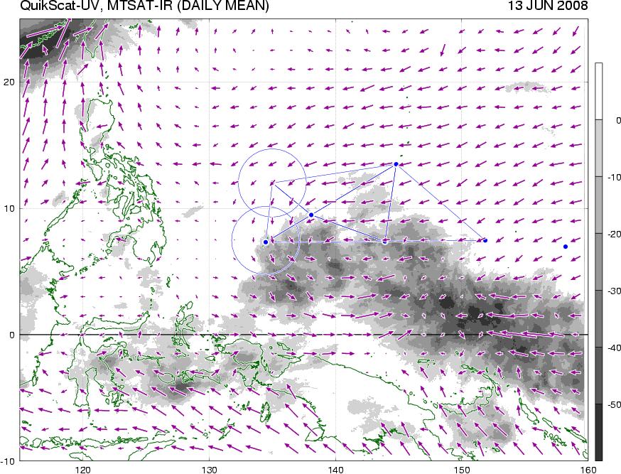

16 Horizontal distribution (11-14 June) 11 JUNE 13 JUNE MIRAI YAP PALAU Kelvin 12 JUNE 14 JUNE


17 Horizontal distribution (15-18 June) 15 JUNE 17 JUNE TD 16 JUNE 18 JUNE TY Fengshen


18 Horizontal distribution (19-22 June) 19 JUNE 21 JUNE 20 JUNE 22 JUNE


")


19 Evolution of Cloud Bands (relative to pre-tc center) Convective Burst


20 Meso-scale convection and vorticity at the cyclogenesis stage Mesoscale convective vortices in the mid troposphere ( mainly within the fore-side cloud system)


 Top")
21 Meso-scale convection and vorticity at the cyclogenesis stage Vertical cross section (color: radial vel., contour: radar echo) Top of spiral cloud band Vorticity signal


22 NICAM TC Fengshen simulation Stretched-7km-grid; Init 12UTC 16 th Jun (Genesis: 12UTC 18 th ) NICAM: 12UTC 18 th NICAM: 12UTC 20 th NICAM: 12UTC 22 nd JCDAS: 12UTC 18 th JCDAS: 12UTC 20 th JCDAS: 12UTC 22 nd
 OBS.")
 NICAM (rain, UV")
23 Simulation using NICAM (dx=7km) OBS. (MW rain, sea-level wind) NICAM (rain, UV at z=10m)
, Page 38: (http://metocph.nmci.navy.mil/jtwc/atcr/2008atcr/2008atcr.")

24 Erroneous poleward bias in ALL forecast models Forecast Track Errors JTWC: CONW AVNI EGRI: GFNI NGPI JTWC official forecasts JTWC model consensus GFS model UK Met Office model GFDN model NRL NOGAPS model JTWC s 2008 Annual Tropical Cyclone Report (ATCR), Page 38: ( It is highly unusual to have all forecast guidance be incorrect, so JTWC forecasters were reluctant to go against all the models, resulting in highly inaccurate official forecasts. Immediate evaluation by the modeling community is necessary to determine the root causes of the unreliability of the dynamic models in this case.
25 Track forecast (init. 00UTC, 20 June) JMA weekly ensemble (51 members) JMA typhoon ensemble (11 members) JMA GSM (20km resolution)
 JMA weekly ensemble (51 members) JMA typhoon ensemble (11")
26 Track forecast (init. 00UTC, 20 June) JMA weekly ensemble (51 members) JMA typhoon ensemble (11 members) JMA GSM (20km resolution) ECMWF ensemble (51 members)
27 SATELLITE COMPARISONS 3.5KM MESH SIMULATIONS AND CLOUD PROPERTIES

28 NICAM 3.5 km mesh global simulation comparable to satellite observation Ice cloud evaluation by split windows Inoue et al.(2009, JGR, submitted)


29 Cloud ice Snow Calipso/CloudSat simulated reflectivities by COSP Calipso CloudSat


30 observation IWP NICAM Iga et al. (2009,in preparation) Waliser et al. (2009) NICAM IWP is larger than the observed range of IWP.


31 IWC NICAM CS4L100 NICAM IWC is larger in the tropics RAVE fvmmf
32 Cloud Microphysics Schemes of NICAM Grabowski (1998) NSW6 (Tomita 2008,JMSJ) Single-moment 6-categories of water NDW6 (Seiki-Mitsui) Double-moment 6-categories of water

33 Stretch-NICAM exp. Use of NICAM as a regional model: local- CRM: (Tomita, 2008,JMSJ) dx=2.5km-250km Stretch factor=100, Glevel8 Integration: Sensitivity to cloud microphysics scheme NSW6

34 Stretch-NICAM exp. 5UTC 2 Jan Cloud band Tropical Cyclone ISOBEL
35 CloudSat/CALIPSO TC Cloud Bands NICAM with COSP

36 NICAM Cloud Properties
37 Sensitivity to cloud microphysics schemes: CFADS of CloudSat/CALIPSO signals using COSP CloudSat/CALIPSO Grabowski(1998), NICAM-GCRM 3.5km (90-130E, 20S-20N) NSW6 (Tomita 2008), stretched-nicam dx=2.5~5km


38 Pilot simulations of 2-moment cloud model with Global 7km resolution. Comparisons with satellites and further challenges. (Validation of 2-moment cloud model) Nakajima lab. Seiki Tatsuya. 38
39 NICAM simulations Summary MJO and ISV (Miura et al., 2007; Nasuno et al., 2009 JMSJ; Liu et al, 2009 MWR; Oouchi et al GRL) TC (Fudeyasu et al. 2009, GRL) Diurnal cycle (Sato et al. 2009, J. Clim.) Ensembles for ISV & TC genesis (Taniguchi & Yanase 2009 JMSJ) Evaluation using satellite data GMS CloudSat/CALIPSO & TRMM PR
40 Contribution to YOTC May 2008: TC Nargis & after ISV/Northward Propagation and TC genesis June 2008: TC Fengshen Obs. Palau2008/2010 Experiments, plan and suggestions Global 3.5 km run for a week June 2008 MJO Ensemble simulations 7km 1 or 2 months x several runs Multiscale structure and meso-scale convective systems Comparison with satellite observations Output data, time interval?
Observation and Simulation of the Genesis of Typhoon Fengshen (2008) in the Tropical Western Pacific
 in the Tropical Western Pacific") Observation and Simulation of the Genesis of Typhoon Fengshen (2008) in the Tropical Western Pacific Hiroyuki Yamada 1, Wataru Yanase 2, Masaki Sato 1,2, Kunio Yoneyama 1, and Ryuichi Shirooka 1 (1: JAMSTEC,
Observation and Simulation of the Genesis of Typhoon Fengshen (2008) in the Tropical Western Pacific Hiroyuki Yamada 1, Wataru Yanase 2, Masaki Sato 1,2, Kunio Yoneyama 1, and Ryuichi Shirooka 1 (1: JAMSTEC,
2006/12/29. MISMO workshop Yokohama, 25 November, 2008
 Global cloud-resolving simulations of MJO events in November 2006 - January 2007 ---multiscale structure --- 2006/12/29 MTSAT-1R NICAM Tomoe NASUNO, Masaki SATOH, Hiroaki MIURA, NICAM development group
Workshop on Sub- seasonal to Seasonal Predictability of Monsoons
 Masaki Satoh (AORI, The University of Tokyo) Masuo Nakano (JAMSTEC) Tomoki Miyakawa (AORI, The University of Tokyo) Yoshiyuki Kajikawa (AICS, RIKEN) and NICAM group members Workshop on Sub- seasonal to
A workshop on the theme of clouds, circulation and climate sensitivity March in Schloss Ringberg, Germany
 Clouds, circulation, and climate sensitivity simulated by NICAM Global nonhydrostatic model simulations with single and double momentum cloud microphysics schemes and evaluation using satellite simulators
Evaluation and Improvement of Clouds Simulated by the Global Nonhydrostatic Model NICAM and Satellite Data
 Evaluation and Improvement of Clouds Simulated by the Global Nonhydrostatic Model NICAM and Satellite Data NICAM: dx=3.5 km simulations EarthCARE satellite mission (2016?) Joint Simulator for Satellite
Impact of Tropical Disturbance on the Indian Summer Monsoon Onset Simulated by a Global Cloud-System-Resolving Model
 80 SOLA, 2015, Vol. 11, 80 84, doi:10.2151/sola.2015-020 Impact of Tropical Disturbance on the Indian Summer Monsoon Onset Simulated by a Global Cloud-System-Resolving Model Yoshiyuki Kajikawa 1, Tsuyoshi
- Introduction - Technical Presentation 49 th Session of the Typhoon Committee. Yokohama, Japan 21 February Munehiko Yamaguchi
 - Introduction - The Latest Model Simulation and Observational Studies related to Tropical Cyclone in Japan Technical Presentation 49 th Session of the Typhoon Committee Yokohama, Japan 21 February 2017
Development of a High-Resolution Coupled Atmosphere-Ocean-Land General Circulation Model for Climate System Studies
 Chapter 1 Earth Science Development of a High-Resolution Coupled Atmosphere-Ocean-Land General Circulation Model for Climate System Studies Project Representative Tatsushi Tokioka Frontier Research Center
Future activities of HPC in meteorology using K-computer
 The 14th ECMWF Workshop on High Performance Computing in Meteorology Future activities of HPC in meteorology using K-computer Hirofumi Tomita Research Institute for Global Change / JAMSTEC Advanced Institute
Theoretical and Modeling Issues Related to ISO/MJO
 Theoretical and Modeling Issues Related to ISO/MJO Tim Li Department of Meteorology and IPRC University of Hawaii DYNAMO workshop, April 13-14, Boulder, Colorado 1. MJO Initiation issue: Role of air- sea
Saharan Dust Induced Radiation-Cloud-Precipitation-Dynamics Interactions
 Saharan Dust Induced Radiation-Cloud-Precipitation-Dynamics Interactions William K. M. Lau NASA/GSFC Co-authors: K. M. Kim, M. Chin, P. Colarco, A. DaSilva Atmospheric loading of Saharan dust Annual emission
Development of a Coupled Atmosphere-Ocean-Land General Circulation Model (GCM) at the Frontier Research Center for Global Change
 at the Frontier Research Center for Global Change") Chapter 1 Atmospheric and Oceanic Simulation Development of a Coupled Atmosphere-Ocean-Land General Circulation Model (GCM) at the Frontier Research Center for Global Change Project Representative Tatsushi
Chapter 1 Atmospheric and Oceanic Simulation Development of a Coupled Atmosphere-Ocean-Land General Circulation Model (GCM) at the Frontier Research Center for Global Change Project Representative Tatsushi
Structure of Tropical Convective Systems in Aqua-Planet Experiments: Radiative-Convective Equilibrium Versus the Earth-Like Experiment
 220 SOLA, 2016, Vol. 12, 220224, doi:10.2151/sola.2016-044 Structure of Tropical Convective Systems in Aqua-Planet Experiments: Radiative-Convective Equilibrium Versus the Earth-Like Experiment Masaki
Examination of Tropical Cyclogenesis using the High Temporal and Spatial Resolution JRA-25 Dataset
 Examination of Tropical Cyclogenesis using the High Temporal and Spatial Resolution JRA-25 Dataset Masato Sugi Forecast Research Department, Meteorological Research Institute, Japan Correspondence: msugi@mri-jma.go.jp
The Influence of Atmosphere-Ocean Interaction on MJO Development and Propagation
 DISTRIBUTION STATEMENT A. Approved for public release; distribution is unlimited. The Influence of Atmosphere-Ocean Interaction on MJO Development and Propagation PI: Sue Chen Naval Research Laboratory
Myung-Sook Park, Russell L. Elsberry and Michael M. Bell. Department of Meteorology, Naval Postgraduate School, Monterey, California, USA
 Latent heating rate profiles at different tropical cyclone stages during 2008 Tropical Cyclone Structure experiment: Comparison of ELDORA and TRMM PR retrievals Myung-Sook Park, Russell L. Elsberry and
Projection of changes in tropical cyclone activity and cloud height due to greenhouse warming: Global cloud system resolving approach
 Click Here for Full Article GEOPHYSICAL RESEARCH LETTERS, VOL. 37,, doi:10.1029/2010gl042518, 2010 Projection of changes in tropical cyclone activity and cloud height due to greenhouse warming: Global
Introduction to tropical meteorology and deep convection
 Introduction to tropical meteorology and deep convection TMD Lecture 1 Roger K. Smith University of Munich A satpix tour of the tropics The zonal mean circulation (Hadley circulation), Inter- Tropical
Data assimilation, Real-time forecasting and high-resolution
 Data assimilation, Real-time forecasting and high-resolution simulation during the 2011 CINDY/DYNAMO field campaign Tim Li and X. Fu (UH), Kunio Yoneyama and Tomoe Nasuno (JAMSTEC) Real time observational
Role of the Vertical Structure of a Simulated Tropical Cyclone in Its Motion: A Case Study of Typhoon Fengshen (2008)
") SOLA, 2016, Vol. 12, 203 208, doi:10.2151/sola.2016-041 203 Role of the Vertical Structure of a Simulated Tropical Cyclone in Its Motion: A Case Study of Typhoon Fengshen (2008) Hiroyuki Yamada 1, Tomoe
SOLA, 2016, Vol. 12, 203 208, doi:10.2151/sola.2016-041 203 Role of the Vertical Structure of a Simulated Tropical Cyclone in Its Motion: A Case Study of Typhoon Fengshen (2008) Hiroyuki Yamada 1, Tomoe
Introduction to tropical meteorology and deep convection
 Introduction to tropical meteorology and deep convection Roger K. Smith University of Munich A satpix tour of the tropics The zonal mean circulation (Hadley circulation), Inter- Tropical Convergence Zone
1. INTRODUCTION: 2. DATA AND METHODOLOGY:
 27th Conference on Hurricanes and Tropical Meteorology, 24-28 April 2006, Monterey, CA 3A.4 SUPERTYPHOON DALE (1996): A REMARKABLE STORM FROM BIRTH THROUGH EXTRATROPICAL TRANSITION TO EXPLOSIVE REINTENSIFICATION
Dynamical System Approach to Organized Convection Parameterization for GCMs. Mitchell W. Moncrieff
 Dynamical System Approach to Organized Convection Parameterization for GCMs Mitchell W. Moncrieff Atmospheric Modeling & Predictability Section Climate & Global Dynamics Laboratory NCAR Year of Tropical
Verification of the Seasonal Forecast for the 2005/06 Winter
 Verification of the Seasonal Forecast for the 2005/06 Winter Shingo Yamada Tokyo Climate Center Japan Meteorological Agency 2006/11/02 7 th Joint Meeting on EAWM Contents 1. Verification of the Seasonal
Global-to-regional simulation of aerosols with 10 km grid spacing
 Workshop: Oct 17-19, 2016 @Ho Chi Minh City, Vietnam Global-to-regional simulation of aerosols with 10 km grid spacing Daisuke GOTO ( 五藤大輔 ) (goto.daisuke@nies.go.jp) National Institute for Environmental
ENSO Outlook by JMA. Hiroyuki Sugimoto. El Niño Monitoring and Prediction Group Climate Prediction Division Japan Meteorological Agency
 ENSO Outlook by JMA Hiroyuki Sugimoto El Niño Monitoring and Prediction Group Climate Prediction Division Outline 1. ENSO impacts on the climate 2. Current Conditions 3. Prediction by JMA/MRI-CGCM 4. Summary
UPDATE OF REGIONAL WEATHER AND SMOKE HAZE (December 2017)
") UPDATE OF REGIONAL WEATHER AND SMOKE HAZE (December 2017) 1. Review of Regional Weather Conditions for November 2017 1.1 In November 2017, Southeast Asia experienced inter-monsoon conditions in the first
UPDATE OF REGIONAL WEATHER AND SMOKE HAZE (December 2017) 1. Review of Regional Weather Conditions for November 2017 1.1 In November 2017, Southeast Asia experienced inter-monsoon conditions in the first
Development of a High-Resolution Coupled Atmosphere-Ocean-Land General Circulation Model for Climate System Studies
 Chapter Earth Science Development of a High-Resolution Coupled Atmosphere-Ocean-Land General Circulation Model for Climate System Studies Project Representative Akira Noda Frontier Research Center for
Understanding the Microphysical Properties of Developing Cloud Clusters during TCS-08
 DISTRIBUTION STATEMENT A: Approved for public release; distribution is unlimited. Understanding the Microphysical Properties of Developing Cloud Clusters during TCS-08 PI: Elizabeth A. Ritchie Department
Pacific Storm Track at Different Horizontal Resolutions Snap-shot of Column Liquid Water Content
 Color Plates Pacific Storm Track at Different Horizontal Resolutions Snap-shot of Column Liquid Water Content Fig. 2.8 A snapshot of the cyclone frontal-system by a nonhydrostatic model run with two very
A Live Report from Pre-YMC Campaign in Sumatra
 A Live Report from Pre-YMC Campaign in Sumatra Kunio Yoneyama and Japan & Indonesia Pre-YMC campaign Team - An Update on Japanese Activities since Singapore Workshop - Outline 1) Boreal winter of 2017/18
The Properties of Convective Clouds Over the Western Pacific and Their Relationship to the Environment of Tropical Cyclones
 The Properties of Convective Clouds Over the Western Pacific and Their Relationship to the Environment of Tropical Cyclones Principal Investigator: Dr. Zhaoxia Pu Department of Meteorology, University
Intraseasonal Variability and TC Forecasting
 Intraseasonal Variability and TC Forecasting 2017 WMO Class Eric Blake Hurricane Specialist National Hurricane Center 3/1/2017 Outline Madden-Julian Oscillation (MJO) MJO analysis tools Kelvin Waves Brief
High Resolution Modeling of Multi-scale Cloud and Precipitation Systems Using a Cloud-Resolving Model
 Chapter 1 Atmospheric and Oceanic Simulation High Resolution Modeling of Multi-scale Cloud and Precipitation Systems Using a Cloud-Resolving Model Project Representative Kazuhisa Tsuboki Author Kazuhisa
Outline of 4 Lectures
 Outline of 4 Lectures 1. Sept. 17, 2008: TC best track definition and datasets, global distribution of TCs; Review of history of meteorological satellites, introducing different orbits, scanning patterns,
T-PARC and TCS08 (Submitted by Pat Harr, Russell Elsberry and Tetsuo Nakazawa)
") WORLD METEOROLOGICAL ORGANIZATION COMMISSION FOR ATMOSPHERIC SCIENCES INTERNATIONAL CORE STEERING COMMITTEE FOR THORPEX Eighth Session DWD, Offenbach (2 4 November 2009) CAS/ICSC-8/DOC4.1 (3 X.2009) Item:
WORLD METEOROLOGICAL ORGANIZATION COMMISSION FOR ATMOSPHERIC SCIENCES INTERNATIONAL CORE STEERING COMMITTEE FOR THORPEX Eighth Session DWD, Offenbach (2 4 November 2009) CAS/ICSC-8/DOC4.1 (3 X.2009) Item:
Recent Developments in Climate Information Services at JMA. Koichi Kurihara Climate Prediction Division, Japan Meteorological Agency
 Recent Developments in Climate Information Services at JMA Koichi Kurihara Climate Prediction Division, Japan Meteorological Agency 1 Topics 1. Diagnosis of the Northern Hemispheric circulation in December
Products of the JMA Ensemble Prediction System for One-month Forecast
 Products of the JMA Ensemble Prediction System for One-month Forecast Shuhei MAEDA, Akira ITO, and Hitoshi SATO Climate Prediction Division Japan Meteorological Agency smaeda@met.kishou.go.jp Contents
Toward Seamless Weather-Climate Prediction with a Global Cloud Resolving Model
 DISTRIBUTION STATEMENT A. Approved for public release; distribution is unlimited. Toward Seamless Weather-Climate Prediction with a Global Cloud Resolving Model PI: Tim Li IPRC/SOEST, University of Hawaii
TTL & H 2 O Brewer-Dobson Circulation (~years) Waves. Waves T T TEMPERATURE. Tropical Tropopause Layer (TTL) Equator. Stratosphere Ozone Layer QBO
 Waves. Waves T T TEMPERATURE. Tropical Tropopause Layer (TTL) Equator. Stratosphere Ozone Layer QBO") H 2 O in Strato. - Radiative Balance (IR cooling) - Source of HOx Ozone Layer H 2 O Distribution in Strato. - Dehydration/cold trap in TTL (microphysics of cirrus clouds matter!) - Brewer-Dobson Circ.
H 2 O in Strato. - Radiative Balance (IR cooling) - Source of HOx Ozone Layer H 2 O Distribution in Strato. - Dehydration/cold trap in TTL (microphysics of cirrus clouds matter!) - Brewer-Dobson Circ.
8.2 Numerical Study of Relationships between Convective Vertical Velocity, Radar Reflectivity Profiles, and Passive Microwave Brightness Temperatures
 8.2 Numerical Study of Relationships between Convective Vertical Velocity, Radar Reflectivity Profiles, and Passive Microwave Brightness Temperatures Yaping Li, Edward J. Zipser, Steven K. Krueger, and
Atmospheric circulation analysis for seasonal forecasting
 Training Seminar on Application of Seasonal Forecast GPV Data to Seasonal Forecast Products 18 21 January 2011 Tokyo, Japan Atmospheric circulation analysis for seasonal forecasting Shotaro Tanaka Climate
2006 Annual Tropical Cyclone Report U.S. Naval Maritime Forecast Center/ Joint Typhoon Warning Center Pearl Harbor, Hawaii
 Annual Tropical Cyclone Report U.S. Naval Maritime Forecast Center/ Joint Typhoon Warning Center Pearl Harbor, Hawaii Composite MODIS true color image from the Aqua satellite of Super Typhoon C (Ioke)
Tropical Cyclone Formation/Structure/Motion Studies
 Tropical Cyclone Formation/Structure/Motion Studies Patrick A. Harr Department of Meteorology Naval Postgraduate School Monterey, CA 93943-5114 phone: (831) 656-3787 fax: (831) 656-3061 email: paharr@nps.edu
MESO-NH cloud forecast verification with satellite observation
 MESO-NH cloud forecast verification with satellite observation Jean-Pierre CHABOUREAU Laboratoire d Aérologie, University of Toulouse and CNRS, France http://mesonh.aero.obs-mip.fr/chaboureau/ DTC Verification
Characteristics of extreme convection over equatorial America and Africa
 Characteristics of extreme convection over equatorial America and Africa Manuel D. Zuluaga, K. Rasmussen and R. A. Houze Jr. Atmospheric & Climate Dynamics Seminar Department of Atmospheric Sciences, University
Science Objectives contained in three categories
 Summer THORPEX-Pacific Asian Regional Campaign/Tropical Cyclone Structure-08 Experiments and Collaborative Efforts Science Objectives contained in three categories Increase predictability of high-impact
Hurricanes and Tropical Weather Systems:
 Hurricanes and Tropical Weather Systems: An influence on weather in parts of the USA Meteorology 411 Iowa State University Week 2 Bill Gallus Classification/Terminology Tropical Disturbance enhanced convection
JEPP/HARIMAU radar wind profiler network over the Indonesian maritime continent
 JEPP/HARIMAU radar wind profiler network over the Indonesian maritime continent Shuichi Mori 1, H. Hashiguchi 2, M. Kawashima 3, and M. D. Yamanaka 1 1 RIGC/JAMSTEC, 2 RISH/Kyoto University, 3 ILTS/Hokkaido
What is the Madden-Julian Oscillation (MJO)?
?") What is the Madden-Julian Oscillation (MJO)? Planetary scale, 30 90 day oscillation in zonal wind, precipitation, surface pressure, humidity, etc., that propagates slowly eastward Wavelength = 12,000 20,000
What is the Madden-Julian Oscillation (MJO)? Planetary scale, 30 90 day oscillation in zonal wind, precipitation, surface pressure, humidity, etc., that propagates slowly eastward Wavelength = 12,000 20,000
The 2009 Hurricane Season Overview
 The 2009 Hurricane Season Overview Jae-Kyung Schemm Gerry Bell Climate Prediction Center NOAA/ NWS/ NCEP 1 Overview outline 1. Current status for the Atlantic, Eastern Pacific and Western Pacific basins
Characterizing Clouds and Convection Associated with the MJO Using the Year of Tropical Convection (YOTC) Collocated A-Train and ECMWF Data Set
 Collocated A-Train and ECMWF Data Set") Characterizing Clouds and Convection Associated with the MJO Using the Year of Tropical Convection (YOTC) Collocated A-Train and ECMWF Data Set Wei-Ting Chen Department of Atmospheric Sciences, National
Characterizing Clouds and Convection Associated with the MJO Using the Year of Tropical Convection (YOTC) Collocated A-Train and ECMWF Data Set Wei-Ting Chen Department of Atmospheric Sciences, National
7 December 2016 Tokyo Climate Center, Japan Meteorological Agency
 Summary of the 2016 Asian Summer Monsoon 7 December 2016 Tokyo Climate Center, Japan Meteorological Agency This report summarizes the characteristics of the surface climate and atmospheric/oceanographic
Impact of Resolution on Extended-Range Multi-Scale Simulations
 DISTRIBUTION STATEMENT A. Approved for public release; distribution is unlimited. Impact of Resolution on Extended-Range Multi-Scale Simulations Carolyn A. Reynolds Naval Research Laboratory Monterey,
Variability of West African Weather Systems. Chris Thorncroft Department of Atmospheric and Environmental Sciences University at Albany
 Variability of West African Weather Systems Chris Thorncroft Department of Atmospheric and Environmental Sciences University at Albany Variability of West African Weather Systems (1) Convectively Coupled
NICAM Nonhydrostatic Icosahedral
 NICAM Nonhydrostatic Icosahedral Atmospheric Model Masaki Satoh (AORI, the Univ. of Tokyo/RIGC, JAMSTEC) 13 Sep 2008 (7km-NICAM by H.L.Tanaka) 1 th Workshop on Dynamical Cores for Climate Models December
Tropical Waves. John Cangialosi and Lixion Avila National Hurricane Center. WMO Region IV Tropical Cyclone Workshop
 Tropical Waves John Cangialosi and Lixion Avila National Hurricane Center WMO Region IV Tropical Cyclone Workshop Outline Basic definition Schematic diagrams/interactions Operational products/forecasts
Lectures on Tropical Cyclones
 Lectures on Tropical Cyclones Chapter 1 Observations of Tropical Cyclones Outline of course Introduction, Observed Structure Dynamics of Mature Tropical Cyclones Equations of motion Primary circulation
Impact of Intraseasonal Variations to the Spatial Distribution of Coastal Heavy Rainbands Intensity During HARIMAU IOP 2011 in the West Sumatera
 Impact of Intraseasonal Variations to the Spatial Distribution of Coastal Heavy Rainbands Intensity During HARIMAU IOP 2011 in the West Sumatera Ardhi Adhary Arbain, Yekti Galihselowati Agency for the
Convection Trigger: A key to improving GCM MJO simulation? CRM Contribution to DYNAMO and AMIE
 Convection Trigger: A key to improving GCM MJO simulation? CRM Contribution to DYNAMO and AMIE Xiaoqing Wu, Liping Deng and Sunwook Park Iowa State University 2009 DYNAMO Workshop Boulder, CO April 13-14,
WRF MODEL STUDY OF TROPICAL INERTIA GRAVITY WAVES WITH COMPARISONS TO OBSERVATIONS. Stephanie Evan, Joan Alexander and Jimy Dudhia.
 WRF MODEL STUDY OF TROPICAL INERTIA GRAVITY WAVES WITH COMPARISONS TO OBSERVATIONS. Stephanie Evan, Joan Alexander and Jimy Dudhia. Background Small-scale Gravity wave Inertia Gravity wave Mixed RossbyGravity
Observed Structure and Environment of Developing and Nondeveloping Tropical Cyclones in the Western North Pacific using Satellite Data
 DISTRIBUTION STATEMENT A. Approved for public release; distribution is unlimited. Observed Structure and Environment of Developing and Nondeveloping Tropical Cyclones in the Western North Pacific using
Operational Use of Scatterometer Winds at JMA
 Operational Use of Scatterometer Winds at JMA Masaya Takahashi Numerical Prediction Division, Japan Meteorological Agency (JMA) 10 th International Winds Workshop, Tokyo, 26 February 2010 JMA Outline JMA
KUALA LUMPUR MONSOON ACTIVITY CENT
 T KUALA LUMPUR MONSOON ACTIVITY CENT 2 ALAYSIAN METEOROLOGICAL http://www.met.gov.my DEPARTMENT MINISTRY OF SCIENCE. TECHNOLOGY AND INNOVATIO Introduction Atmospheric and oceanic conditions over the tropical
A Case Study of an Outbreak of Twin Tropical Cyclones
 MARCH 2009 S C H R E C K A N D M O L I N A R I 863 A Case Study of an Outbreak of Twin Tropical Cyclones CARL J. SCHRECK III AND JOHN MOLINARI Department of Earth and Atmospheric Sciences, University at
Precipitation Structure and Processes of Typhoon Nari (2001): A Modeling Propsective
: A Modeling Propsective") Precipitation Structure and Processes of Typhoon Nari (2001): A Modeling Propsective Ming-Jen Yang Institute of Hydrological Sciences, National Central University 1. Introduction Typhoon Nari (2001) struck
Precipitation Structure and Processes of Typhoon Nari (2001): A Modeling Propsective Ming-Jen Yang Institute of Hydrological Sciences, National Central University 1. Introduction Typhoon Nari (2001) struck
Vertical heating rate profiles associated with MJO in JRA-25
 Vertical heating rate profiles associated with MJO in JRA-25 Tatsuya Motoyama 1 1 Climate Prediction Division, Japan Meteorological Agency t-motoyama@met.kishou.go.jp INTRODUCTION To study vertical heating
Diurnal cycle of precipitation in the tropics simulated in a global cloud-resolving model
 Diurnal cycle of precipitation in the tropics simulated in a global cloud-resolving model 1 1 Tomonori Sato,, Hiroaki Miura, 1, Masaki Satoh, 1, Yukari N. Takayabu, Yuqing Wang 1 Center for Climate System
Towards a new understanding of monsoon depressions
 Towards a new understanding of monsoon depressions William Boos Dept. of Geology & Geophysics May 2, 25 with contributions from John Hurley & Naftali Cohen Financial support: What is a monsoon low pressure
On Improving Precipitation Diurnal Cycle and Frequency in Global Climate Models
 On Improving Precipitation Diurnal Cycle and Frequency in Global Climate Models Xiaoqing Wu Department of Geological and Atmospheric Sciences Iowa State University (ISU) The YOTC International Science
A GCM with cloud microphysics and its MJO simulation
 DOI 10.1186/s40562-016-0048-1 RESEARCH LETTER A GCM with cloud microphysics and its MJO simulation In Sik Kang 1,2*, Min Seop Ahn 1 and Young Min Yang 3 Open Access Abstract The present study examines
Extratropical transition of tropical cyclones: Operational forecasting challenges. Matthew Kucas Joint Typhoon Warning Center Pearl Harbor, HI, USA
 Extratropical transition of tropical cyclones: Operational forecasting challenges Matthew Kucas Joint Typhoon Warning Center Pearl Harbor, HI, USA Outline Motivation for discussion Brief overview of tropical
Using Microwave Limb Sounder (MLS) Data to Evaluate Model Cloud Ice Fields
 Data to Evaluate Model Cloud Ice Fields") Using Microwave Limb Sounder (MLS) Data to Evaluate Model Cloud Ice Fields Workshop on Parametrization of Clouds in Large-scale Models, ECMWF, Nov 2006 Duane Waliser/JPL Frank Li/JPL MLS Team/J. Jiang/JPL
Using Microwave Limb Sounder (MLS) Data to Evaluate Model Cloud Ice Fields Workshop on Parametrization of Clouds in Large-scale Models, ECMWF, Nov 2006 Duane Waliser/JPL Frank Li/JPL MLS Team/J. Jiang/JPL
Introduction of products for Climate System Monitoring
 Introduction of products for Climate System Monitoring 1 Typical flow of making one month forecast Textbook P.66 Observed data Atmospheric and Oceanic conditions Analysis Numerical model Ensemble forecast
Life Cycle of Convective Systems over Western Colombia
 Life Cycle of Convective Systems over Western Colombia Meiry Sakamoto Uiversidade de São Paulo, São Paulo, Brazil Colombia Life Cycle of Convective Systems over Western Colombia Convective System (CS)
Introduction of Seasonal Forecast Guidance. TCC Training Seminar on Seasonal Prediction Products November 2013
 Introduction of Seasonal Forecast Guidance TCC Training Seminar on Seasonal Prediction Products 11-15 November 2013 1 Outline 1. Introduction 2. Regression method Single/Multi regression model Selection
The feature of atmospheric circulation in the extremely warm winter 2006/2007
 The feature of atmospheric circulation in the extremely warm winter 2006/2007 Hiroshi Hasegawa 1, Yayoi Harada 1, Hiroshi Nakamigawa 1, Atsushi Goto 1 1 Climate Prediction Division, Japan Meteorological
Understanding the Microphysical Properties of Developing Cloud Clusters During TCS-08
 Understanding the Microphysical Properties of Developing Cloud Clusters During TCS-08 PI: Elizabeth A. Ritchie Department of Atmospheric Sciences, University of Arizona Room 542, Physics-Atmospheric Sciences
JTWC's Use of TRMM in Typhoon Forecast Operations
 Use of TRMM in Typhoon Forecast Operations JTWC's Use of TRMM in Typhoon Forecast Operations Slide 1/24 Use of TRMM in Typhoon Forecast Operations Slide 2/24 Opening Comments The current microwave satellite
2. Outline of the MRI-EPS
 2. Outline of the MRI-EPS The MRI-EPS includes BGM cycle system running on the MRI supercomputer system, which is developed by using the operational one-month forecasting system by the Climate Prediction
Improved rainfall and cloud-radiation interaction with Betts-Miller-Janjic cumulus scheme in the tropics
 Improved rainfall and cloud-radiation interaction with Betts-Miller-Janjic cumulus scheme in the tropics Tieh-Yong KOH 1 and Ricardo M. FONSECA 2 1 Singapore University of Social Sciences, Singapore 2
The influence of observations propagated by convectively coupled equatorial waves
 Quarterly Journal of the Royal Meteorological Society Q. J. R. Meteorol. Soc. 137: 641 655, April 2011 A The influence of observations propagated by convectively coupled equatorial waves Qoosaku Moteki,
Observing system experiments of MTSAT-2 Rapid Scan Atmospheric Motion Vector for T-PARC 2008 using the JMA operational NWP system
 Tenth International Winds Workshop 1 Observing system experiments of MTSAT-2 Rapid Scan Atmospheric Motion Vector for T-PARC 2008 using the JMA operational NWP system Koji Yamashita Japan Meteorological
NWS Operational Marine and Ocean Forecasting. Overview. Ming Ji. Ocean Prediction Center National Weather Service/NCEP. CIOSS/CoRP
 NWS Operational Marine and Ocean Forecasting Overview Ming Ji Ocean Prediction Center National Weather Service/NCEP CIOSS/CoRP CoRP Symposium Corvallis, OR Aug. 12-13, 13, 2008 Titanic Telegram Marine
UPDATE OF REGIONAL WEATHER AND SMOKE HAZE (September 2017)
") UPDATE OF REGIONAL WEATHER AND SMOKE HAZE (September 2017) 1. Review of Regional Weather Conditions in August 2017 1.1 Southwest Monsoon conditions continued to prevail in the region in August 2017. The
UPDATE OF REGIONAL WEATHER AND SMOKE HAZE (September 2017) 1. Review of Regional Weather Conditions in August 2017 1.1 Southwest Monsoon conditions continued to prevail in the region in August 2017. The
Primary Factors Contributing to Japan's Extremely Hot Summer of 2010
 temperature anomalies by its standard deviation for JJA 2010 Primary Factors Contributing to Japan's Extremely Hot Summer of 2010 Nobuyuki Kayaba Climate Prediction Division,Japan Meteorological Agancy
Department of Atmospheric Sciences, National Taiwan University, Taipei, Taiwan
 10A.4 TROPICAL CYCLONE FORMATIONS IN THE SOUTH CHINA SEA CHENG-SHANG LEE 1 AND YUNG-LAN LIN* 1, 2 1 Department of Atmospheric Sciences, National Taiwan University, Taipei, Taiwan 2 Taipei Aeronautic Meteorological
AN OBSERVING SYSTEM EXPERIMENT OF MTSAT RAPID SCAN AMV USING JMA MESO-SCALE OPERATIONAL NWP SYSTEM
 AN OBSERVING SYSTEM EXPERIMENT OF MTSAT RAPID SCAN AMV USING JMA MESO-SCALE OPERATIONAL NWP SYSTEM Koji Yamashita Japan Meteorological Agency / Numerical Prediction Division 1-3-4, Otemachi, Chiyoda-ku,
ENSO Cycle: Recent Evolution, Current Status and Predictions. Update prepared by Climate Prediction Center / NCEP 23 April 2012
 ENSO Cycle: Recent Evolution, Current Status and Predictions Update prepared by Climate Prediction Center / NCEP 23 April 2012 Outline Overview Recent Evolution and Current Conditions Oceanic Niño Index
Seasonal Climate Outlook for South Asia (June to September) Issued in May 2014
 Issued in May 2014") Ministry of Earth Sciences Earth System Science Organization India Meteorological Department WMO Regional Climate Centre (Demonstration Phase) Pune, India Seasonal Climate Outlook for South Asia (June
Ministry of Earth Sciences Earth System Science Organization India Meteorological Department WMO Regional Climate Centre (Demonstration Phase) Pune, India Seasonal Climate Outlook for South Asia (June
NCAS-Climate, Department of Meteorology, University of Reading, Reading, United Kingdom
 1342 J O U R N A L O F T H E A T M O S P H E R I C S C I E N C E S VOLUME 70 The Effects of Explicit versus Parameterized Convection on the MJO in a Large-Domain High-Resolution Tropical Case Study. Part
Diabatic processes and the structure of extratropical cyclones
 Geophysical and Nonlinear Fluid Dynamics Seminar AOPP, Oxford, 23 October 2012 Diabatic processes and the structure of extratropical cyclones Oscar Martínez-Alvarado R. Plant, J. Chagnon, S. Gray, J. Methven
Long Range Forecasts of 2015 SW and NE Monsoons and its Verification D. S. Pai Climate Division, IMD, Pune
 Long Range Forecasts of 2015 SW and NE Monsoons and its Verification D. S. Pai Climate Division, IMD, Pune Other Contributors: Soma Sen Roy, O. P. Sreejith, Kailas, Madhuri, Pallavi, Mahendra and Jasmine
Tropical Cyclogenesis within an Equatorial Rossby Wave Packet
 APRIL 2007 M O L I N A R I E T A L. 1301 Tropical Cyclogenesis within an Equatorial Rossby Wave Packet JOHN MOLINARI, KELLY LOMBARDO,* AND DAVID VOLLARO Department of Earth and Atmospheric Sciences, University
Impact assessment on disasters
 The 5th International Coordination Group (ICG) Meeting GEOSS Asian Water Cycle Initiative (AWCI), Dec. 16, 2009. Impact assessment on disasters Eiichi Nakakita Disaster Prevention Research Institute Kyoto
M. Mohapatra and D. R. Pattanaik
 Understanding and forecasting of intra-seasonal extremes of southwest monsoon circulation and precipitation over India M. Mohapatra and D. R. Pattanaik IMD, New Delhi Email : m.mohapatra@imd.gov.in Annual
Upgrade of JMA s Typhoon Ensemble Prediction System
 Upgrade of JMA s Typhoon Ensemble Prediction System Masayuki Kyouda Numerical Prediction Division, Japan Meteorological Agency and Masakazu Higaki Office of Marine Prediction, Japan Meteorological Agency
Mesoscale and High Impact Weather in the South American Monsoon Leila M. V. Carvalho 1 and Maria A. F. Silva Dias 2 1
 Mesoscale and High Impact Weather in the South American Monsoon Leila M. V. Carvalho 1 and Maria A. F. Silva Dias 2 1 University of California, Santa Barbara 2 University of Sao Paulo, Brazil Objectives
Forecasting at the interface between weather and climate: beyond the RMM-index
 Forecasting at the interface between weather and climate: beyond the RMM-index Augustin Vintzileos University of Maryland ESSIC/CICS-MD Jon Gottschalck NOAA/NCEP/CPC Outline The Global Tropics Hazards
El Niño, South American Monsoon, and Atlantic Niño links as detected by a. TOPEX/Jason Observations
 El Niño, South American Monsoon, and Atlantic Niño links as detected by a decade of QuikSCAT, TRMM and TOPEX/Jason Observations Rong Fu 1, Lei Huang 1, Hui Wang 2, Paola Arias 1 1 Jackson School of Geosciences,