GOFC-GOLD Regional Networks. Krishna Vadrevu NASA MSFC
|
|
|
- Shannon Young
- 5 years ago
- Views:
Transcription
1 GOFC-GOLD Regional Networks Krishna Vadrevu NASA MSFC
2 GOFC-GOLD Implementation Teams (IT) Land Cover Characteristics and Change Fire Monitoring and Mapping Working Groups (WG) Working Group on Reducing Emissions from Deforestation and Forest Degradation (REDD) Group on Biomass Monitoring Regional Networks Interface between IT and regional data users

3 GOFC-GOLD 20 th Anniversary, Georgia, 2017

4 GOFC-GOLD Regional Networks

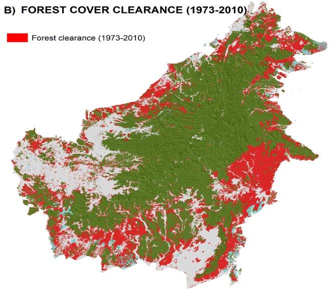
5

6 Of the 11 networks, 6 networks showing interests in Fires SAFNET RedLATIF SEARRIN SARIN WARN Miombo
7 GOFC-GOLD Website Update GOFC-GOLD FAO website - very old info not actively updated) - (contacted Dough Muchoney and shut it down) GOFC-GOLD Fire-IT website GOFC-GOLD Land Cover IT website GOFC-GOLD START website - Regional Networks Information is being posted at GOFC- GOLD Fire website; Consistency is needed!

8 New GOFC-GOLD Website being Developed (Domain name already purchased )

9 -It will have Land, Fire and Regional Network Information / Links at one site Major change w.r.t. Regional Networks All RN leads will have access to update their own Network Pages Directly!
10 Updates from SEARRIN and SARIN Both network researchers are represented in the annual + thematic meetings of South/Southeast Asia Research Initiative (SARI) LCLUC Due to funding issues, we are combining events under one umbrella. Dedicated Fires/Biomass Burning sessions involving Regional Scientists for 1.5-days; Funding is for mostly Meetings + Trainings through JAXA NIES (since 7-years and will continue)
")
11 Quezon city, Philippines th May, participants 3-day meeting with sessions on LCLUC, Agriculture and Land- Atmopsheric Interactions 1.5-day - Land Atmospheric Interactions Parallel sessions 3-day training with 100- participants (31 May + 1, 2 nd June)
12 Brief History of INSAT Satellites Satellite Meteorology in IMD really started in 1982 with the launch of INSAT-1A which was a multipurpose satellite meant for services to Meteorology, Television and Communication. Before that, Indian meteorologists were using analog imageries received from U.S. Polar orbiting satellites series of TIROS-N. Many satellites for meteorological purposes were launched after the launch of INSAT-1A as given below: INSAT-1A 10 April 1982 Two Channel VHRR INSAT-1B 30 August,1983 INSAT-1C 21 July 1988 INSAT-1D 12 June,1990 INSAT-2A 10 July, 1992 INSAT-2B 23 July,1993 INSAT-2E 03 April 1999 Three Channel VHRR KALPANA-1 12 Sept.2002 INSAT-3A 10 April 2003 INSAT-3D 25 July, 2013 C-Band Transponders mainly for communication Some with Meteorological Observations INSAT-3D 26 July, channel imager and 19 channel sounder

13 INSAT-3D - India s Advanced Weather Satellite India's advanced weather satellite INSAT-3D was launched in the early hours of July 26, 2013 from Kourou, French Guyana, and has successfully been placed in Geosynchronous orbit. It carries four payloads Imager (Six Channels) Sounder (Nineteen Channels) Most of the products are ingested by Indian Meteorological Department (IMD) - National Centre of Medium Range Weather Prediction (NCMRWF). Data Relay Transponder(DRT) Satellite Aided Search and Rescue European Center of Medium range Weather Forecast (ECMWF) and United Kingdom Meteorological Office (UKMET) use INSAT-3D derived atmospheric winds in their global models.
14 Imager (Six Channels) Spectral Band Wavelength(µm) Ground Resolution Visible km SWIR km MIR km WV km TIR km TIR km Generates images of the earth disk in every 26 minutes
15 INSAT-3D Sounder Channels Characteristics Detector Ch. No. l c (mm) n c (cm -1 ) NE Principal absorbing gas Purpose CO 2 Stratosphere temperature CO 2 Tropopause temperature CO 2 Upper-level temperature Long wave CO 2 Mid-level temperature CO 2 Low-level temperature water vapor Total precipitable water water vapor Surface temp., moisture window Surface temperature ozone Total ozone Mid wave water vapor Low-level moisture water vapor Mid-level moisture water vapor Upper-level moisture N 2 O Low-level temperature N 2 O Mid-level temperature Short wave CO 2 Upper-level temperature CO 2 Boundary-level temp window Surface temperature window Surface temp., moisture Visible visible Cloud 19 channel Sounder, with 18 narrow spectral channels in short-wave infrared, middle infrared and long wave infrared regions and one channel in the visible region; Signals every 1-hour

 Mission Country /")


 2025 - CO2")
 OCO-2 (2014-)")
 GOSAT-2")
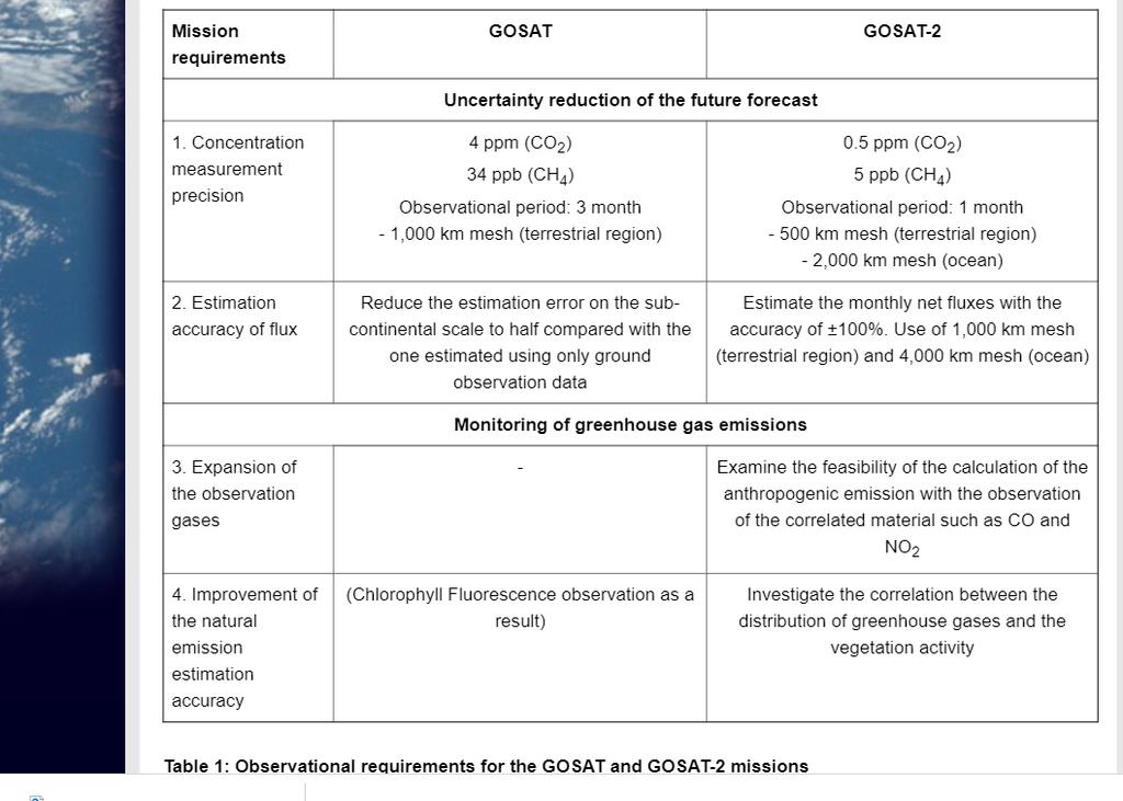
16 Almost 10-years of continuous CO2 data Satellites for Greenhouse Gases Observation (Column observations) Mission Country / Organization Period GHGs Comments ENVISAT / SCIAMACHY ESA CO2, CH4 GOSAT Japan CO2, CH4 FTS OCO-2 US CO2 Grating GHGSat-D/CLAIRE GHGSat (Canada) CO2, CH4 Fabry Pérot TanSat China CO2 Grating Sentinel-5p / TROPOMI EC CH4 FY-3D / GAS China CO2, CH4 GF-5 / GMI China CO2, CH4 Spatial Heterodyne GOSAT-2 Japan FY CO2, CH4 FTS ISS / OCO-3 US CO2, Grating MicroCarb France CO2 MERLIN France/ Germany CH4 Laser GeoCARB US CO2, CH4 Geostationary, Grating GOSAT-3 Japan ?? Sentinel 7 (EC) CO2 Constellation ENVISAT ( ) GOSAT (2009-) OCO-2 (2014-) GHGSat-D (2016-) TanSat (2016-) Sentinel 5p (2017-) GOSAT-2 (FY2018-) MicroCarb (2021-) MERLIN (2021-) FY-3D (2017-) GF-5 (2018-) OCO-3 (2019 -)
17 GOSAT-2 Improved re-visit time to 3 days (from 6-days) Improved resolution TANSO cloud imager Band 1-3: 500 m, Band 4: 1500 m,
18
19
20
21


22 GHG measurement data in a GAW Station in Indonesia (in Bukit Koto Tabang, West Sumatera, Indonesia) West Sumatera Ozone Analyzer CO Analyzer Pyranometer BAM Nephlometer Air Flask Sampler HVAS Passive Air Sampler


23 GHG measurements 52 Monitoring Stations in Malaysia


24 Chiang Mai, Thailand Consistent and year-long mixing layer height measurements with LiDAR in the mountain valley of Chiang Mai

25 3-new stations; Dibrugarh, North East India; and Calicut, Kerala, Mandalay, Myanmar


26 WRF-Chem modelling - GFED peat emissions could be underestimated by a factor of 3
27 Next SARI - South + Southeast Asia GOFC networks meeting in Malaysia th July 2019 (meeting) th July, 2019 (training)
Update on SCOPE-Nowcasting Pilot Project Real Time Ocean Products Suman Goyal Scientist-E
 Update on SCOPE-Nowcasting Pilot Project Real Time Ocean Products Suman Goyal Scientist-E 19-22 Nov 2013 SCOPE-Nowcasting-1 Agenda Item 5 Pilot Projects Overview Users /Clients User requirements Product
VALIDATION OF INSAT-3D DERIVED RAINFALL. (Submitted by Suman Goyal, IMD) Summary and Purpose of Document
 Summary and Purpose of Document") WORLD METEOROLOGICAL ORGANIZATION COMMISSION FOR BASIC SYSTEMS OPEN PROGRAMME AREA GROUP ON INTEGRATED OBSERVING SYSTEMS INTER-PROGRAMME EXPERT TEAM ON SATELLITE UTILIZATION AND PRODUCTS SECOND SESSION
WORLD METEOROLOGICAL ORGANIZATION COMMISSION FOR BASIC SYSTEMS OPEN PROGRAMME AREA GROUP ON INTEGRATED OBSERVING SYSTEMS INTER-PROGRAMME EXPERT TEAM ON SATELLITE UTILIZATION AND PRODUCTS SECOND SESSION
Radiative Transfer Model based Bias Correction in INSAT-3D/3DR Thermal Observations to Improve Sea Surface Temperature Retrieval
 Radiative Transfer Model based Bias Correction in INSAT-3D/3DR Thermal Observations to Improve Sea Surface Temperature Retrieval Rishi K Gangwar, Buddhi P Jangid, and Pradeep K Thapliyal Space Applications
METEOSAT THIRD GENERATION
 METEOSAT THIRD GENERATION FACTS AND FIGURES MONITORING WEATHER AND CLIMATE FROM SPACE A HIGHLY INNOVATIVE GEOSTATIONARY SATELLITE SYSTEM FOR EUROPE AND AFRICA The Meteosat Third Generation (MTG) system
The Status of NIES GOSAT-2 Project and NIES Satellite Observation Center
 12th International Workshop on Greenhouse Gas Measurements from Space June 7 9, 2016, Kyoto, Japan The Status of NIES GOSAT-2 Project and NIES Satellite Observation Center GOSAT GOSAT-2 T. Matsunaga, S.
Contribution to global Earth observation from satellites
 Contribution to global Earth observation from satellites - JAXA s Earth Observation strategy - April 16, 2008 Makoto Kajii Japan Aerospace Exploration Agency Earth Observation Summits and GEOSS 1 st EO
SPACE TECHNOLOGY INSTITUTE, VNREDSat-1 and DATA PROVIDER NODE (DPN) REPORT
 REPORT") 4th Joint Project Team Meeting for Sentinel Asia STEP3 (JPTM2017) 8-9 March 2017 SPACE TECHNOLOGY INSTITUTE, VNREDSat-1 and DATA PROVIDER NODE (DPN) REPORT www.sti.vast.ac.vn CONTENT 1. Overview of Space
4th Joint Project Team Meeting for Sentinel Asia STEP3 (JPTM2017) 8-9 March 2017 SPACE TECHNOLOGY INSTITUTE, VNREDSat-1 and DATA PROVIDER NODE (DPN) REPORT www.sti.vast.ac.vn CONTENT 1. Overview of Space
Updates on CMA FENGYUN Meteorological Satellite Programs
 Updates on CMA FENGYUN Meteorological Satellite Programs Peng ZHANG National Satellite Meteorological Center, China Meteorological Administration (NSMC/CMA) 29 Nov. - 5 Dec. 2017, Darmstadt, Germany 1.
Fifty Years of Operational Environmental Satellites: The U.S. Experience
 United Nations Committee on the Peaceful Uses of Outer Space Vienna, Austria June 15, 2010 Fifty Years of Operational Environmental Satellites: The U.S. Experience Mr. Charles Baker Deputy Assistant Administrator
Preparation for FY-4A. (Submitted by Xiang Fang, CMA)
") WORLD METEOROLOGICAL ORGANIZATION COMMISSION FOR BASIC SYSTEMS OPEN PROGRAMME AREA GROUP ON INTEGRATED OBSERVING SYSTEMS EXPERT TEAM ON SATELLITE UTILIZATION AND PRODUCTS ET-SUP-8/Doc. 10.3 (2.IV.2014)
WORLD METEOROLOGICAL ORGANIZATION COMMISSION FOR BASIC SYSTEMS OPEN PROGRAMME AREA GROUP ON INTEGRATED OBSERVING SYSTEMS EXPERT TEAM ON SATELLITE UTILIZATION AND PRODUCTS ET-SUP-8/Doc. 10.3 (2.IV.2014)
sentinel-2 COLOUR VISION FOR COPERNICUS
 sentinel-2 COLOUR VISION FOR COPERNICUS SATELLITES TO SERVE By providing a set of key information services for a wide range of practical applications, Europe s Copernicus programme is providing a step
International Cooperation in Operational Environmental Satellites: The U.S. Experience
 Committee on the Peaceful Uses of Outer Space Science and Technology Sub committee Forty seventh session February 17, 2010 Vienna, Austria International Cooperation in Operational Environmental Satellites:
RETRIEVAL AND APPLICATIONS OF ATMOSPHERIC MOTION VECTORS USING INSAT-3D/3DR DATA : ISRO STATUS
 RETRIEVAL AND APPLICATIONS OF ATMOSPHERIC MOTION VECTORS USING INSAT-3D/3DR DATA : ISRO STATUS Sanjib K Deb, D K Sankhala, C M Kishtawal Atmospheric and Oceanic Sciences Group Space Applications Centre
Simulation and Validation of INSAT-3D sounder data at NCMRWF
 Simulation and Validation of INSAT-3D sounder data at NCMRWF S. Indira Rani and V. S. Prasad National Centre for Medium Range Weather Forecasting (NCMRWF) Earth System Science Organization (ESSO) Ministry
Measuring Carbon Dioxide from the A-Train: The OCO-2 Mission
 Measuring Carbon Dioxide from the A-Train: The OCO-2 Mission David Crisp, OCO-2 Science Team Leader for the OCO-2 Science Team Jet Propulsion Laboratory, California Institute of Technology March 2013 Copyright
Latest status and developments at IMD since CGMS-45
 Latest status and developments at IMD since CGMS-45 CGMS-46, Plenary session, agenda item IMD-ISRO-WP-01 Presenter: S K Peshin Report Prepared By: S K Peshin, Virendra Singh, A.K.Mitra Overview - Planning
Indian National (Weather) SATellites for Agrometeorological Applications
 SATellites for Agrometeorological Applications") Indian National (Weather) SATellites for Agrometeorological Applications Bimal K. Bhattacharya Agriculture-Terrestrial Biosphere- Hydrology Group Space Applications Centre (ISRO) Ahmedabad 380015, India
Indian National (Weather) SATellites for Agrometeorological Applications Bimal K. Bhattacharya Agriculture-Terrestrial Biosphere- Hydrology Group Space Applications Centre (ISRO) Ahmedabad 380015, India
Status of Indian Satellite Meteorological Programme
 Status of Indian Satellite Meteorological Programme Pradeep K Thapliyal Space Applications Centre (SAC) Indian Space research Organisation (ISRO) Ahmedabad (INDIA) Email: pkthapliyal@sac.isro.gov.in International
FLUXNET and Remote Sensing Workshop: Towards Upscaling Flux Information from Towers to the Globe
 FLUXNET and Remote Sensing Workshop: Towards Upscaling Flux Information from Towers to the Globe Space-Based Measurements of CO 2 from the Japanese Greenhouse Gases Observing Satellite (GOSAT) and the
Back to basics: From Sputnik to Envisat, and beyond: The use of satellite measurements in weather forecasting and research: Part 1 A history
 Back to basics: From Sputnik to Envisat, and beyond: The use of satellite measurements in weather forecasting and research: Part 1 A history Roger Brugge 1 and Matthew Stuttard 2 1 NERC Data Assimilation
COORDINATION GROUP FOR METEOROLOGICAL SATELLITES AND GOFC-GOLD
 Coordination Group for Meteorological Satellites - CGMS COORDINATION GROUP FOR METEOROLOGICAL SATELLITES AND GOFC-GOLD Mitch Goldberg, CGMS co-liaison to CGMS Working group 2 satellite data and products
Status of the Sentinel-5 Precursor Presented by C. Zehner S5p, S4, and S5 Missions Manager - ESA
 Status of the Sentinel-5 Precursor Presented by C. Zehner S5p, S4, and S5 Missions Manager - ESA European response to global needs: to manage the environment, to mitigate the effects of climate change
The CEOS Atmospheric Composition Constellation (ACC) An Example of an Integrated Earth Observing System for GEOSS
 An Example of an Integrated Earth Observing System for GEOSS") The CEOS Atmospheric Composition Constellation (ACC) An Example of an Integrated Earth Observing System for GEOSS Presentation Authors: E. Hilsenrath NASA, C. Zehner ESA, J. Langen ESA, J. Fishman NASA
The CEOS Atmospheric Composition Constellation (ACC) An Example of an Integrated Earth Observing System for GEOSS Presentation Authors: E. Hilsenrath NASA, C. Zehner ESA, J. Langen ESA, J. Fishman NASA
Results from the Atmosphere & Climate projects in Dragon-3
 Results from the Atmosphere & Climate projects in Dragon-3 R.J. van der A, J. Bai, A. Ding, N. Hao, Y. Xue, C. Varotsos, R. Ma, S. Loiselle, F. Huang, V. Sofieva, Y. Liu, H. Boesch, Z. Liu, O. Reitebuch,
Earth Observations Supporting the Implementation of the SDGs in the Asia Pacific Region. CO2 Monitoring from Space: TanSat and GF-5/GMI Mission Status
 The 9TH GEOSS Asia-Pacific Symposium Earth Observations Supporting the Implementation of the SDGs in the Asia Pacific Region CO2 Monitoring from Space: TanSat and GF-5/GMI Mission Status Yi Liu Institute
The current status of FY-3D
 The current status of FY-3D Xiang Fang National Satellite Meteorological Center, China Meteorological Administration (NSMC/CMA) OUTLINE Overview Key instruments onboard FY-3D Products and data service
The Copernicus Sentinel-5 Mission: Daily Global Data for Air Quality, Climate and Stratospheric Ozone Applications
 SENTINEL-5 The Copernicus Sentinel-5 Mission: Daily Global Data for Air Quality, Climate and Stratospheric Ozone Applications Yasjka Meijer RHEA for ESA, Noordwijk, NL 15/04/2016 Co-Authors: Jörg Langen,
GOSAT update. June Prepared by JAXA EORC Presented by David Crisp
 CEOS AC-VC GOSAT update June Prepared by JAXA EORC Presented by David Crisp GOSAT & GOSAT-2 Organization ORGANIZATION GOSAT is the joint project of JAXA, MOE (Ministry of the Environment) and NIES (National
REVISION OF THE STATEMENT OF GUIDANCE FOR GLOBAL NUMERICAL WEATHER PREDICTION. (Submitted by Dr. J. Eyre)
") WORLD METEOROLOGICAL ORGANIZATION Distr.: RESTRICTED CBS/OPAG-IOS (ODRRGOS-5)/Doc.5, Add.5 (11.VI.2002) COMMISSION FOR BASIC SYSTEMS OPEN PROGRAMME AREA GROUP ON INTEGRATED OBSERVING SYSTEMS ITEM: 4 EXPERT
WORLD METEOROLOGICAL ORGANIZATION Distr.: RESTRICTED CBS/OPAG-IOS (ODRRGOS-5)/Doc.5, Add.5 (11.VI.2002) COMMISSION FOR BASIC SYSTEMS OPEN PROGRAMME AREA GROUP ON INTEGRATED OBSERVING SYSTEMS ITEM: 4 EXPERT
The current status of FY-3D. (Submitted by Xiang Fang, CMA) Summary and Purpose of Document
 Summary and Purpose of Document") WORLD METEOROLOGICAL ORGANIZATION COMMISSION FOR BASIC SYSTEMS OPEN PROGRAMME AREA GROUP ON INTEGRATED OBSERVING SYSTEMS INTER-PROGRAMME EXPERT TEAM ON SATELLITE UTILIZATION AND PRODUCTS FOURTH SESSION
WORLD METEOROLOGICAL ORGANIZATION COMMISSION FOR BASIC SYSTEMS OPEN PROGRAMME AREA GROUP ON INTEGRATED OBSERVING SYSTEMS INTER-PROGRAMME EXPERT TEAM ON SATELLITE UTILIZATION AND PRODUCTS FOURTH SESSION
Lecture 4b: Meteorological Satellites and Instruments. Acknowledgement: Dr. S. Kidder at Colorado State Univ.
 Lecture 4b: Meteorological Satellites and Instruments Acknowledgement: Dr. S. Kidder at Colorado State Univ. US Geostationary satellites - GOES (Geostationary Operational Environmental Satellites) US
Status of ESA EO Programmes
 Status of ESA EO Programmes 54 th ESSC Plenary Meeting 24 November 2017 Maurice Borgeaud, ESA Head of the ESA Earth Observation Science, Applications and Climate Department Issue/Revision: 0.0 Reference:
CNES actions towards risk mitigation and climate change monitoring
 United nations / Germany International Conference: International cooperation Towards Low-Emission and Resilient Societies 22-24 Nov 2017, Bonn CNES actions towards risk mitigation and climate change monitoring
Data Format and Visualization Agenda
 Data Format and Visualization Agenda- 7.2.2 ET-SUP-8 (14.04.2014) Suman Goyal, Satellite Meteorology Division, India Meteorological Department, Suman_goyal61@yahoo.co.in Visualization Methods The satellite
10 emergency observation requests were successfully processed during the period
 ISRO s Inputs for the Sentinel Asia DPN and JPT meeting being held during 13-16, 16, November 2012 November 2012 Sentinel Asia Activity Spectrum - A dedicated Sentinel Asia server established at NRSC,
Teruyuki Nakajima Director, Earth Observation Research Center (EORC) Japan Aerospace Exploration Agency (JAXA)
 Japan Aerospace Exploration Agency (JAXA)") Tokyo Inter. Conference on the Forest Governance Initiative - Improving Forest Governance using Forest Early Warning Systems and Satellite Technologies - October 24-26, 2017 Teruyuki Nakajima Director,
Tokyo Inter. Conference on the Forest Governance Initiative - Improving Forest Governance using Forest Early Warning Systems and Satellite Technologies - October 24-26, 2017 Teruyuki Nakajima Director,
Observing methane from space. Daniel J. Jacob with Johannes D. Maasakkers, Daniel J. Varon, Jianxiong Sheng
 Observing methane from space Daniel J. Jacob with Johannes D. Maasakkers, Daniel J. Varon, Jianxiong Sheng Satellite orbits Molniya 40,000 km (apogee) SUN 150 million km Polar LEO 200-2,000 km Geostationary
Monitoring Air Pollution from Space
 Monitoring Air Pollution from Space Media Regional Training Workshop 16 th Nov 20 th Nov 2015 Shreta Ghimire International Centre for Integrated Mountain Development Kathmandu, Nepal Why do we study air
February 2007 in Jakarta, Indonesia
 February 2007 in Jakarta, Indonesia MEXT Special Coordination Funds for for Promoting Science and Technology Asia S&T Strategic Cooperation Program International Research for Prevention and Mitigation
Developments on air quality modeling, Prof. Dr. Hennie Kelder Royal Netherlands Meteorological Inst KNMI University of Technology, Eindhoven
 Developments on air quality modeling, satellite observations and services in Europ Prof. Dr. Hennie Kelder Royal Netherlands Meteorological Inst KNMI University of Technology, Eindhoven GMES: Global Monitoring
JAXA s Contributions to the Climate Change Monitoring
 0 JAXA s Contributions to the Climate Change Monitoring June 7, 2011 Takao Akutsu Planning Manager Japan Aerospace Exploration Agency (JAXA) Japanese Main Activities of Earth Observation 1 GEOSS 10 years
MSG system over view
 MSG system over view 1 Introduction METEOSAT SECOND GENERATION Overview 2 MSG Missions and Services 3 The SEVIRI Instrument 4 The MSG Ground Segment 5 SAF Network 6 Conclusions METEOSAT SECOND GENERATION
REMOTE SENSING OF GREENHOUSE GASES AND THEIR SOURCES AND SINKS
 REMOTE SENSING OF GREENHOUSE GASES AND THEIR SOURCES AND SINKS André Butz Karlsruhe Institute of Technology (KIT), IMK-ASF, Karlsruhe, Germany Arne Babenhauserheide, Marco Bertleff, Rarmiro Checa-Garcia,
Air quality. EU GEMS project. European air quality satellite missions. Hennie Kelder. KNMI University of Technology, Eindhoven
 Air quality EU GEMS project European air quality satellite missions Hennie Kelder KNMI University of Technology, Eindhoven Global and regional Earth-System (atmosphere) Monitoring using Satellite and in-situ
Satellite observation of atmospheric dust
 Satellite observation of atmospheric dust Taichu Y. Tanaka Meteorological Research Institute, Japan Meteorological Agency 11 April 2017, SDS WAS: Dust observation and modeling @WMO, Geneva Dust observations
APPENDIX 2 OVERVIEW OF THE GLOBAL PRECIPITATION MEASUREMENT (GPM) AND THE TROPICAL RAINFALL MEASURING MISSION (TRMM) 2-1
 AND THE TROPICAL RAINFALL MEASURING MISSION (TRMM) 2-1") APPENDIX 2 OVERVIEW OF THE GLOBAL PRECIPITATION MEASUREMENT (GPM) AND THE TROPICAL RAINFALL MEASURING MISSION (TRMM) 2-1 1. Introduction Precipitation is one of most important environmental parameters.
APPENDIX 2 OVERVIEW OF THE GLOBAL PRECIPITATION MEASUREMENT (GPM) AND THE TROPICAL RAINFALL MEASURING MISSION (TRMM) 2-1 1. Introduction Precipitation is one of most important environmental parameters.
Megha-Tropiques Presentation by Indian Delegation at the 55th Session of UNCOPUOS Vienna 12 June 2012
 Megha-Tropiques Presentation by Indian Delegation at the 55 th Session of UNCOPUOS Vienna 12 June 2012 Megha-Tropiques Mission Indo-French Joint Satellite for studying tropical atmosphere Megha in Sanskrit
JAXA Remote Sensing Satellite Missions Utilization for Earth and Environment Observation
 JAXA Remote Sensing Satellite Missions Utilization for Earth and Environment Observation 27 th June 2013 Toshiyoshi Kimura EORC/JAXA Inventory, Modeling and Climate Impacts of Greenhouse Gas emissions
Infrastructure monitoring using SAR interferometry
 Infrastructure monitoring using SAR interferometry Hossein Nahavandchi Roghayeh Shamshiri Norwegian University of Science and Technology (NTNU), Department of Civil and Environmental Engineering Geodesy
Early Results from the NASA Orbiting Carbon Observatory-2 (OCO-2)
") Early Results from the NASA Orbiting Carbon Observatory-2 (OCO-2) David Crisp, OCO-2 Science Team Leader for the OCO-2 Science Team California Institute of Technology, Jet Propulsion Laboratory 08 June
Early Results from the NASA Orbiting Carbon Observatory-2 (OCO-2) David Crisp, OCO-2 Science Team Leader for the OCO-2 Science Team California Institute of Technology, Jet Propulsion Laboratory 08 June
Feature-tracked 3D Winds from Satellite Sounders: Derivation and Impact in Global Models
 Feature-tracked 3D Winds from Satellite Sounders: Derivation and Impact in Global Models David Santek 1, A.-S. Daloz 1, S. Tushaus 1, M. Rogal 1, W. McCarty 2 1 Space Science and Engineering Center/University
Atmospheric Basics AOSC 200 Tim Canty
 Atmospheric Basics AOSC 200 Tim Canty Class Web Site: http://www.atmos.umd.edu/~tcanty/aosc200 Topics for today: Structure of the Atmosphere Temperature vs height Atmospheric pressure Atmospheric composition
Instrumentation planned for MetOp-SG
 Instrumentation planned for MetOp-SG Bill Bell Satellite Radiance Assimilation Group Met Office Crown copyright Met Office Outline Background - the MetOp-SG programme The MetOp-SG instruments Summary Acknowledgements:
Long-lead prediction of the 2015 fire and haze episode in Indonesia
 Long-lead prediction of the 2015 fire and haze episode in Indonesia Robert Field 1,2 Dilshad Shawki 3, Michael Tippett 2, Bambang Hero Saharjo 4, Israr Albar 5, Dwi Atmoko 6, Apostolos Voulgarakis 1 1.
An Air Quality and Greenhouse Gas Mission focused on Northern Regions
 An Air Quality and Greenhouse Gas Mission focused on Northern Regions Ray Nassar * and Chris McLinden Environment and Climate Change Canada *ray.nassar@canada.ca CEOS ACC-12, Yonsei University, Korea,
A Questionnaire on the Utilization of Satellite Data from the New Generation of Geostationary Meteorological Satellites
 3.1 User requirements for satellite data utilization, especially for new-generation satellites A Questionnaire on the Utilization of Satellite Data from the New Generation of Geostationary Meteorological
CNES Activity Report. Patrice Henry - CNES WGCV Plenary # 41 Tokyo Sept. 5-7, Working Group on Calibration and Validation
 Activity Report Patrice Henry - Tokyo Sept. 5-7, 2016 Working Group on Calibration and Validation SUMMARY Calibration Monitoring of in-flight Missions Preparation of future Missions Involvement in CEOS/WGCV
Radio Frequency Earth Science
 Radio Frequency Earth Science Overview for Committee On Radio Frequency (CORF) National Academy of Science National Research Council April 27, 2005 Bill.Watson@NASA.Gov Program Executive for Ground Networks
AREP GAW. Overview of GURME. (The WMO GAW Urban Research Meteorology and Environment project) WMO Secretariat
 WMO Secretariat") Overview of GURME (The WMO Urban Research Meteorology and Environment project) Liisa Jalkanen Liisa Jalkanen WMO Secretariat World Meteorological Organization Independent technical UN agency 187 Members
Overview of GURME (The WMO Urban Research Meteorology and Environment project) Liisa Jalkanen Liisa Jalkanen WMO Secretariat World Meteorological Organization Independent technical UN agency 187 Members
South Asian Climate Outlook Forum (SASCOF-6)
") Sixth Session of South Asian Climate Outlook Forum (SASCOF-6) Dhaka, Bangladesh, 19-22 April 2015 Consensus Statement Summary Below normal rainfall is most likely during the 2015 southwest monsoon season
Sixth Session of South Asian Climate Outlook Forum (SASCOF-6) Dhaka, Bangladesh, 19-22 April 2015 Consensus Statement Summary Below normal rainfall is most likely during the 2015 southwest monsoon season
Arctic Weather Every 10 Minutes: Design & Operation of ABI for PCW
 Arctic Weather Every 10 Minutes: Design and Operation of ABI for PCW Dr. Paul C. Griffith and Sue Wirth 31st Space Symposium, Technical Track, Colorado Springs, Colorado This document is not subject to
ISRO Report on the Status of Current and future satellites. Presented to CGMS-44 WP-01 Plenary Session
 ISRO Report on the Status of Current and future satellites Presented to CGMS-44 WP-01 Plenary Session CGMS-44-ISRO 05-10 June 2016 Indian Satellite System for weather parameters Satellite Oceansat-1/ MSMR
4.1 New Generation Satellite Data and Nowcasting Products: Himawari
 4.1 New Generation Satellite Data and Nowcasting Products: Himawari SCOPE-Nowcasting-EP 18-20 September 2017 Koji Yamashita kobo.yamashita@met.kishou.go.jp Meteorological Satellite Center (MSC) Japan Meteorological
H SAF SATELLITE APPLICATION FACILITY ON SUPPORT TO OPERATIONAL HYDROLOGY AND WATER MANAGEMENT EUMETSAT NETWORK OF SATELLITE APPLICATION FACILITIES
 H SAF SATELLITE APPLICATION FACILITY ON SUPPORT TO OPERATIONAL HYDROLOGY AND WATER MANAGEMENT EUMETSAT NETWORK OF SATELLITE APPLICATION FACILITIES H-SAF: SATELLITE PRODUCTS FOR OPERATIONAL HYDROLOGY H-SAF
Atmospheric CO 2 and CH 4 Measurements
 Atmospheric CO 2 and CH 4 Measurements Ray Nassar ray.nassar@ec.gc.ca Climate Research Division, Environment Canada NSERC-CREATE Summer School on Arctic Science, 2013 Beginning of atmospheric CO 2 measurements
Himawari 8/9 data distribution/dissemination plan
 Himawari 8/9 data distribution/dissemination plan Japan Meteorological Agency (JMA) Hidehiko MURATA Himawari is the name of this flower in Japanese ET SUP 8, WMO HQ, Geneva, 14 17 April 2014 1 Outline
Joint RA II/V Workshop on WIGOS for DRR - The Jakarta Declaration - (12-14 October, Jakarta, Indonesia) NMSC/KMA
 NMSC/KMA") Joint RA II/V Workshop on WIGOS for DRR - The Jakarta Declaration - (12-14 October, Jakarta, Indonesia) /KMA dolong@korea.kr Background Enhancement of Member s capabilities for weather forecasts and warnings
Joint RA II/V Workshop on WIGOS for DRR - The Jakarta Declaration - (12-14 October, Jakarta, Indonesia) /KMA dolong@korea.kr Background Enhancement of Member s capabilities for weather forecasts and warnings
Spaceborne Wind Lidar Observations by Aeolus Data Products and Pre-Launch Validation with an Airborne Instrument
 DRAGON 3 Project ID 10532 Cal/Val Spaceborne Wind Lidar Observations by Aeolus Data Products and Pre-Launch Validation with an Airborne Instrument Reitebuch Oliver, Lemmerz Christian, Marksteiner Uwe,
Satellites, Weather and Climate Module 1: Introduction to the Electromagnetic Spectrum
 Satellites, Weather and Climate Module 1: Introduction to the Electromagnetic Spectrum What is remote sensing? = science & art of obtaining information through data analysis, such that the device is not
Status report on current and future satellite systems by EUMETSAT Presented to CGMS-44, Plenary session, agenda item D.1
 Status report on current and future satellite systems by EUMETSAT Presented to CGMS-44, Plenary session, agenda item D.1 CGMS-44-EUMETSAT-WP-19.ppt, version 1 (# 859110), 8 June 2016 MISSION PLANNING YEAR...
FUTURE PLAN AND RECENT ACTIVITIES FOR THE JAPANESE FOLLOW-ON GEOSTATIONARY METEOROLOGICAL SATELLITE HIMAWARI-8/9
 FUTURE PLAN AND RECENT ACTIVITIES FOR THE JAPANESE FOLLOW-ON GEOSTATIONARY METEOROLOGICAL SATELLITE HIMAWARI-8/9 Toshiyuki Kurino Japan Meteorological Agency, 1-3-4 Otemachi Chiyodaku, Tokyo 100-8122,
DRARS Coordination Meeting Contribution from IMD
 DRARS Coordination Meeting Contribution from IMD Dr. Ashim Kumar Mitra Ministry of Earth Sciences India Meteorological Department New Delhi-INDIA 11-13 March 2015 The Processing System of NOAA/METOP/MODIS
CMA Consideration on early-morning orbit satellite
 CMA Consideration on early-morning orbit satellite National Satellite Meteorological Center,CMA Yang Jun CGMS 40 in Lugano, 5-9 Nov., 2012 Outline Background Gap analysis on the sounding data coverage
EUMETSAT Polar System (EPS)
") EUMETSAT Polar System (EPS) Synergetic Operational Earth Observations with the EPS/MetOp System Dieter Klaes EPS Programme Scientist Outline 1. Introduction 2. EPS System and Observations 3. Outlook 1.
EUMETSAT Polar System (EPS) Synergetic Operational Earth Observations with the EPS/MetOp System Dieter Klaes EPS Programme Scientist Outline 1. Introduction 2. EPS System and Observations 3. Outlook 1.
Indian Earth Observation Programme
 Indian Earth Observation Programme Dr. Jai Singh Parihar Dy. Director Remote Sensing Applications Area (RESA) Space Applications Centre (ISRO) Ahmedabad 380 015 India jsparihar@sac.isro.gov.in Presentation
The Status Report of FY-2F
 Seventh Session of the Expert Team on Satellite Utilization and Products The Status Report of FY-2F Presented by Xiang Fang National Satellite Meteorological Center (NSMC) China Meteorological Administration
Updates on Chinese Meteorological Satellite Programs
 6 th Asia/Oceania Meteorological Satellite Users Conference Updates on Chinese Meteorological Satellite Programs Caiying Wei Deputy director-general of NSMC National Satellite Meteorological Center (NSMC)
The O 2 A-band Spectrometer on the NASA Orbiting Carbon Observatory-2 (OCO-2)
") Workshop on Remote sensing in the O 2 A-band The O 2 A-band Spectrometer on the NASA Orbiting Carbon Observatory-2 (OCO-2) David Crisp for the OCO-2 Science Team Jet Propulsion Laboratory, California Institute
Workshop on Remote sensing in the O 2 A-band The O 2 A-band Spectrometer on the NASA Orbiting Carbon Observatory-2 (OCO-2) David Crisp for the OCO-2 Science Team Jet Propulsion Laboratory, California Institute
EUMETSAT Satellite Programmes Use of McIDAS at EUMETSAT
 EUMETSAT Satellite Programmes Use of McIDAS at EUMETSAT Marianne König Peter Miu McIDAS Users' Group Meeting, 07-10 May 2012 Slide 1 EUMETSAT Headquarters Darmstadt McIDAS Users' Group Meeting, 07-10 May
Copernicus Today and Tomorrow GEO Week Group on Earth Observation Geneva, 16 January 2014 The Copernicus Space Infrastructure
 Copernicus Today and Tomorrow GEO Week Group on Earth Observation Geneva, 16 January 2014 The Copernicus Space Infrastructure Thomas Beer, Policy Coordinator, Copernicus Space Office, ESA-ESRIN, Frascati
EUMETSAT Beitrag zu CAMS und C3S. Jörg Schulz. Credits to many EUMETSAT Staff
 ETSAT Beitrag zu CAMS und C3S Jörg Schulz Credits to many ETSAT Staff The Copernicus Programme at ETSAT ETSAT is entrusted by the European Commission; ETSAT s Delegation Agreement is organised in 3 major
JAXA s satellites for Disaster Management and Climate Change
 JAXA s satellites for Disaster Management and Climate Change August 24, 2017 Masanobu TSUJI Japan Aerospace Exploration Agency (JAXA) JAXA Activities Space Transportation Human Space Activities Satellite
CONTRIBUTION TO ATMOSPHERIC ECVs
 CONTRIBUTION TO ATMOSPHERIC ECVs Piera Raspollini, Ugo Cortesi Istituto di Fisica Applicata "Nello Carrara", IFAC-CNR, Firenze Luca Palchetti Istituto Nazionale di Ottica, INO-CNR, Firenze Bianca Maria
FTS measurements of greenhouse gases over Sodankylä, Finland
 FTS measurements of greenhouse gases over Sodankylä, Finland Rigel Kivi, Pauli Heikkinen, Johanna Tamminen, Simo Tukiainen, Hannakaisa Lindqvist, Janne Hakkarainen, Juha Hatakka, Tuomas Laurila, Leif Backman,
Satellite Observations of Greenhouse Gases
 Satellite Observations of Greenhouse Gases Richard Engelen European Centre for Medium-Range Weather Forecasts Outline Introduction Data assimilation vs. retrievals 4D-Var data assimilation Observations
Country Report - Singapore
 Country Report - Singapore The 5th Meeting of the Coordinating Group Vladivostok city, Russky Island, Russia Far Eastern Federal University of the RA II WIGOS Satellite Project 21 October 2017 Outline
Remote sensing to reduce uncertainty in environmental policy in SE Asia. Daniel Friess, Edward L. Webb
 Remote sensing to reduce uncertainty in environmental policy in SE Asia Daniel Friess, Edward L. Webb dan.friess@nus.edu.sg Dramatic mangrove loss 50% of all mangroves lost since 19007 110 000 ha lost
Satellite remote sensing of trace gases - Nadir sounding geometry. Cathy Clerbaux, DR CNRS, LATMOS/IPSL
 Satellite remote sensing of trace gases - Nadir sounding geometry Cathy Clerbaux, DR CNRS, LATMOS/IPSL Cathy.clerbaux@latmos.ipsl.fr Sounding the bottom of the atmosphere Endeavour STS-130 Atmospheric
An Eye in the Sky EUMETSAT. Monitoring Weather, Climate and the Environment
 An Eye in the Sky EUMETSAT Monitoring Weather, Climate and the Environment Slide: 1 Hazardous Weather Slide: 2 Hazardous Weather Slide: 3 Natural Disasters set off by severe weather Slide: 4 EUMETSAT Objectives...
Introduction of Anmyeondo FTS Station as a New TCCON Site
 Introduction of Anmyeondo FTS Station as a New TCCON Site Tae-Young GOO, Young-Suk OH, Jin-Ho Shin, Mi-Lim OU, and Chun-Ho CHOI Global Environment System Research Division National Institute of Meteorological
EUMETSAT SAF NETWORK. Lothar Schüller, EUMETSAT SAF Network Manager
 1 EUMETSAT SAF NETWORK Lothar Schüller, EUMETSAT SAF Network Manager EUMETSAT ground segment overview METEOSAT JASON-2 INITIAL JOINT POLAR SYSTEM METOP NOAA SATELLITES CONTROL AND DATA ACQUISITION FLIGHT
Future Opportunities of Using Microwave Data from Small Satellites for Monitoring and Predicting Severe Storms
 Future Opportunities of Using Microwave Data from Small Satellites for Monitoring and Predicting Severe Storms Fuzhong Weng Environmental Model and Data Optima Inc., Laurel, MD 21 st International TOV
Lecture 4: Meteorological Satellites and Instruments. Acknowledgement: Dr. S. Kidder at Colorado State Univ.
 Lecture 4: Meteorological Satellites and Instruments Acknowledgement: Dr. S. Kidder at Colorado State Univ. Homework for the Spring Break: get some tangible, preliminary results for your final project.
The use and impacts of sea surface temperature from passive microwave measurements
 The use and impacts of sea surface temperature from passive microwave measurements Anne O Carroll 6/12/2017 ECMWF workshop on using low frequency passive microwave measurements in research and operational
F O U N D A T I O N A L C O U R S E
 F O U N D A T I O N A L C O U R S E December 6, 2018 Satellite Foundational Course for JPSS (SatFC-J) F O U N D A T I O N A L C O U R S E Introduction to Microwave Remote Sensing (with a focus on passive
Data Assimilation of Satellite Lidar Aerosol Observations
 Data Assimilation of Satellite Lidar Aerosol Observations Thomas Sekiyama Meteorological Research Institute Japan Meteorological Agency (MRI/JMA) AICS Data Assimilation Workshop, 27 February 2013, Kobe,
JAXA agency report. Masumi MATSUNAGA Satellite Applications and Operations Center(SAOC), JAXA
, JAXA") JAXA agency report Masumi MATSUNAGA Satellite Applications and Operations Center(SAOC), JAXA JAXA Activities Space Transportation Human Space Activities Satellite Programs Lunar & Planetary Exploration
JAXA agency report Masumi MATSUNAGA Satellite Applications and Operations Center(SAOC), JAXA JAXA Activities Space Transportation Human Space Activities Satellite Programs Lunar & Planetary Exploration
The Spatial Information Corridor Contributes to UNISPACE+50. JIANG HUI Director of Internation Cooperation Department
 The Spatial Information Corridor Contributes to UNISPACE+50 JIANG HUI Director of Internation Cooperation Department 01 02 03 What is Belt & Road Spatial Information Corridor? China put forward the "Belt
CORRELATION BETWEEN ATMOSPHERIC COMPOSITION AND VERTICAL STRUCTURE AS MEASURED BY THREE GENERATIONS OF HYPERSPECTRAL SOUNDERS IN SPACE
 CORRELATION BETWEEN ATMOSPHERIC COMPOSITION AND VERTICAL STRUCTURE AS MEASURED BY THREE GENERATIONS OF HYPERSPECTRAL SOUNDERS IN SPACE Nadia Smith 1, Elisabeth Weisz 1, and Allen Huang 1 1 Space Science
Ryuji Yamada Tokyo Climate Center Japan Meteorological Agency E mail: URL:
 Ryuji Yamada Tokyo Center Japan Meteorological Agency E mail: tcc@met.kishou.go.jp URL: http://ds.data.jma.go.jp/tcc/tcc/index.html Tokyo Center (TCC) Established in April 2002 at JMA to support climate