Thunderstorm Nowcast and Forecast for Aviation Safety and Efficiency
|
|
|
- Homer Garrison
- 5 years ago
- Views:
Transcription


1 Thunderstorm Nowcast and Forecast for Aviation Safety and Efficiency Validation by IAGOS flights by D. Stich, C. Forster DLR A. Ritter DLH K. Beswick Univ. Manchester A. Petzold FZ Jülich Joint Annual Meeting of IAGOS and IGAS, CIC Météo France, Toulouse, November 18, 2015


2 Innovative weather forecast system for aviation why? Example thunderstorms icing lightning Adverse weather is responsible for 40-50% of all delays in Europe Thunderstorm activity is the reason for up to 90 % of all delays in the airspace over the USA during the summer months. Thunderstorms are the most dangerous weather phenomenon for aviation (survey with pilots) Thunderstrom information for aviation is still rudimentary these days! hail Goal: Help to increase safety and efficiency for air traffic during adverse weather situations

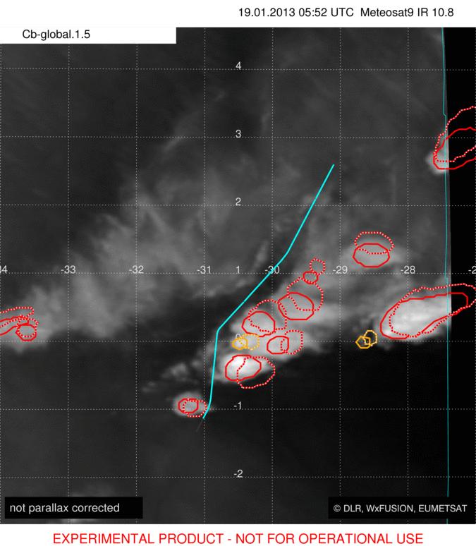
3 Cb-TRAM - Cumulonimbus TRacking And Monitoring satellite data analysis en-route Used MSG (rapidscan) data: WV 6.2 IR 10.8 IR 12.0 HRV potential development -yellow rapid development - orange mature thunderstorm - red


4 Cb-TRAM - Cumulonimbus TRacking And Monitoring satellite data analysis en-route 60 min nowcast Cb-global object

 minutes 1 /")
5 Cb-TRAM - Application area Meteosat Resolution 15 (5) minutes 1 / 4 km (VIS/IR)
 Foto: Capt.")
 of Lufthansa Cityline aircraft via")
6 first successful data link tests cooperation DLR - DLH Foto: Capt. Andreas Borengässer (Lufthansa Cityline) Foto: Capt. Andreas Ritter (Deutsche Lufthansa) Lufthansa GADCom project (Ground Air Data Link Communication): Real time link of Rad-TRAM and Cb-TRAM data in 5 EFBs (Electronic Flight Bags) of Lufthansa Cityline aircraft via mobile network on the ground and later in 5 EFBs of Lufthansa aircraft via FlyNet during cruise-flight


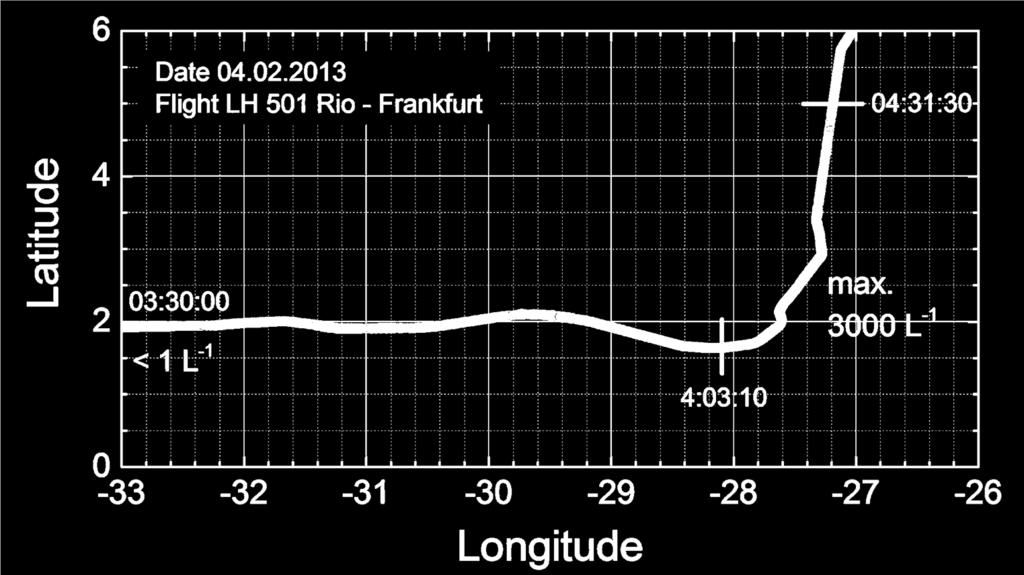
7 The Test Flight: Rio de Janeiro to Frankfurt, February 2013 According to the charts: Business as usual at the ITCZ courtesy of A. Ritter, DLH

8 Then, we uplinked the latest Cb-TRAMs to the erm courtesy of A. Ritter, DLH

9 Then, we uplinked the latest Cb-TRAMs to the erm... planned the safest route with the erm and flew it tactically by looking at the weather radar courtesy of A. Ritter, DLH

10 The result courtesy of A. Ritter, DLH

11 If we would have uplinked the Cb-TRAM a few minutes earlier. we would have seen the gap on the PUGSU DIKEB route or the gap on the ORARO-TASIL route and could have avoided a 300 NM deviation courtesy of A. Ritter, DLH


12 The Test Flight: Rio de Janeiro to Frankfurt, February 2013 LH D-AIGT IAGOS No. 1 Window for Backscatter Cloud Probe
13 The Result as seen from IAGOS Aircraft Regular occurrence of high ice crystal number concentrations on flights to or from Rio de Janeiro Data from Backscatter Cloud Probe


14 The Result as seen from IAGOS Aircraft Regular occurrence of high ice crystal number concentrations on flights to or from Rio de Janeiro Data from Backscatter Cloud Probe
15 The Result as seen from IAGOS Aircraft
16 The Result as seen from IAGOS Aircraft


17 The Result as seen from IAGOS Aircraft


18 The Result as seen from IAGOS Aircraft cirrus Cb outflow preliminary data from 33h in the outflow of convective systems over Amazonia M. Krämer and co-workers, Sept. 2014

19 The Result as seen from IAGOS Aircraft

20 The Result as seen from IAGOS Aircraft Currently have 415 events, but only a fraction of the data have been checked


21 Further IAGOS avoidance events in Cb-TRAM
22 Further IAGOS avoidance events in Cb-TRAM Cb-TRAM detections are accurate, because: The avoidance actions by pilots generally follow the contours No conflicts between on-board radar returns and Cb-TRAM detections Avoidance routes are safe: they basically show low ice crystal number concentrations. If not, in most cases Cb-TRAM detections are encountered. Additional increase in safety by the use of Cb-TRAM Conclusion: Cb-TRAM is qualified for strategic flight route planning!
23 Next Steps DLR Manchester FZ Jülich runs Cb-TRAM for more identified avoidance maneuvers in the MSG Field of View; analyses BCP data for avoidance maneuvers; analyses T, p, RH for avoidance maneuvers; identifies cirrus type encountered during avoidance maneuvers; All (DLR lead) combine information from Cb-TRAM & IAGOS cloud type classification and RH for an assessment of Cb-TRAM; publish results.


24 Summary Thank you for your attention! contact: Severe storms are tracked by satellite data Aircrew reroutes to avoid storms On-board detection by IAGOS- BCP verifies cloud-free regions and cloud type during encounters and improves forecast system
Overview on project activities with regard to thunderstorms
 Overview on project activities with regard to thunderstorms Arnold Tafferner Co-workers: C. Forster, H. Mannstein, T. Zinner, M. Hagen, T. Gerz, DLR Institut für Physik der Atmosphäre (IPA) Wetter&Fliegen
Cb-LIKE: thunderstorm forecasts up to 6 hrs with fuzzy logic
 Cb-LIKE: thunderstorm forecasts up to 6 hrs with fuzzy logic Martin Köhler DLR Oberpfaffenhofen 15th EMS/12th ECAM 07 11 September, Sofia, Bulgaria Long-term forecasts of thunderstorms why? -> Thunderstorms
Sensors and Programs for Inflight Icing. Dr. Darrel Baumgardner Droplet Measurement Technologies Boulder, CO
 Sensors and Programs for Inflight Icing Dr. Darrel Baumgardner Droplet Measurement Technologies Boulder, CO In-Flight Icing Users Technical Interchange Meeting (TIM) Washington, DC 25-26 February 2015
FLYSAFE meteorological hazard nowcasting driven by the needs of the pilot
 FLYSAFE meteorological hazard nowcasting driven by the needs of the pilot R. W. Lunnon, Met Office, Exeter, EX1 3PB, United Kingdom., Thomas Hauf, Thomas Gerz, and Patrick Josse. 1. Introduction The FLYSAFE
Satellite-based thunderstorm tracking, monitoring and nowcasting over South Africa
 Satellite-based thunderstorm tracking, monitoring and nowcasting over South Africa Caroline Forster 1, Estelle de Coning 2, Sebastian Diebel 1, Tobias Zinner 3 EUMETSAT Meteorological Satellite Conference
Weather Technology in the Cockpit (WTIC) Shortfall Analysis of Weather Information in Remote Airspace Friends and Partners of Aviation Weather Summer
 Shortfall Analysis of Weather Information in Remote Airspace Friends and Partners of Aviation Weather Summer") Weather Technology in the Cockpit (WTIC) Shortfall Analysis of Weather Information in Remote Airspace Friends and Partners of Aviation Weather Summer Meeting Tim Myers Metron Aviation August 26, 2015 2
Weather Technology in the Cockpit (WTIC) Shortfall Analysis of Weather Information in Remote Airspace Friends and Partners of Aviation Weather Summer Meeting Tim Myers Metron Aviation August 26, 2015 2
An illustration of the practical use in aviation of operational real-time geostationary satellite data
 An illustration of the practical use in aviation of operational real-time geostationary satellite data Jos de Laat # and Jan-Fokke Meirink Royal Netherlands Meteorological Institute operational use of
NOWCASTING THUNDERSTORM HAZARDS FOR FLIGHT OPERATIONS: THE CB WIMS APPROACH IN FLYSAFE
 26 TH INTERNATIONAL CONGRESS OF THE AERONAUTICAL SCIENCES NOWCASTING THUNDERSTORM HAZARDS FOR FLIGHT OPERATIONS: THE CB WIMS APPROACH IN FLYSAFE A. Tafferner*, C. Forster*, S. Sénési**, Y. Guillou**, P.
Nowcasting of Severe Weather from Satellite Images (for Southern
 Nowcasting of Severe Weather from Satellite Images (for Southern Europe) Petra Mikuš Jurković Forecasting/ nowcasting of convective storms NWP models cannot well predict the exact location and intesity
Improving real time observation and nowcasting RDT. E de Coning, M Gijben, B Maseko and L van Hemert Nowcasting and Very Short Range Forecasting
 Improving real time observation and nowcasting RDT E de Coning, M Gijben, B Maseko and L van Hemert Nowcasting and Very Short Range Forecasting Introduction Satellite Application Facilities (SAFs) are
New Meteorological Services Supporting ATM
 New Meteorological Services Supporting ATM Meteorological Services in the Terminal Area (MSTA)...providing MET services to support a move from Air Traffic Control (ATC) to more integrated and collaborative
SATELLITE SIGNATURES ASSOCIATED WITH SIGNIFICANT CONVECTIVELY-INDUCED TURBULENCE EVENTS
 SATELLITE SIGNATURES ASSOCIATED WITH SIGNIFICANT CONVECTIVELY-INDUCED TURBULENCE EVENTS Kristopher Bedka 1, Wayne Feltz 1, John Mecikalski 2, Robert Sharman 3, Annelise Lenz 1, and Jordan Gerth 1 1 Cooperative
ipads/efbs and Weather the cockpit Captain Joe Burns Managing Director United Airlines Technology and Flight Test
 ipads/efbs and Weather the cockpit Captain Joe Burns Managing Director United Airlines Technology and Flight Test October 12, 2011 How we use weather- 40-50% of all primary delays due to Weather unpredictability!
Nowcasting thunderstorms for aeronautical end-users
 Nowcasting thunderstorms for aeronautical end-users Jean-Marc Moisselin Météo-France, Nowcasting Department co-authors: Céline Jauffret (Météo-France) Overview Introduction SAT RADAR NWP image crédit:
Satellite-based Convection Nowcasting and Aviation Turbulence Applications
 Satellite-based Convection Nowcasting and Aviation Turbulence Applications Kristopher Bedka Cooperative Institute for Meteorological Satellite Studies (CIMSS), University of Wisconsin-Madison In collaboration
Rapidly Developing Thunderstorm (RDT)
") Rapidly Developing Thunderstorm (RDT) Jean-Marc Moisselin, Frédéric Autones Météo-France Nowcasting Department 42, av. Gaspard Coriolis 31057 Toulouse France jean-marc.moisselin@meteo.fr EUMETRAIN Convection
Rapidly Developing Thunderstorm (RDT) Jean-Marc Moisselin, Frédéric Autones Météo-France Nowcasting Department 42, av. Gaspard Coriolis 31057 Toulouse France jean-marc.moisselin@meteo.fr EUMETRAIN Convection
Strengthening the CDM triad: A view from the cockpit
 Strengthening the CDM triad: A view from the cockpit Captain Rocky Stone Chief Technical Pilot United Airlines Friends and Partners in Aviation Weather July 21, 2010 NextGen Weather Concept Current NextGen
Hail nowcast exploiting radar and satellite observations
 Federal Department of Home Affairs FDHA Federal Office of Meteorology and Climatology MeteoSwiss Hail nowcast exploiting radar and satellite observations Ulrich Hamann, Elena Leonarduzzi, Kristopher Bedka,
Smoother Rides Through Better Turbulence Forecasting
 Smoother Rides Through Better Turbulence Forecasting White Paper www.dtn.com / 1.800.610.0777 Copyright 2017 DTN DTN has devoted years of research with some of the top scientists in the aviation weather
Keywords: weather information for ATC, nowcasting, forecasting, severe weather
 26 TH INTERNATIONAL CONGRESS OF THE AERONAUTICAL SCIENCES AN INTEGRATED USER-ORIENTED WEATHER FORECAST SYSTEM FOR AIR TRAFFIC USING REAL- TIME OBSERVATIONS AND MODEL DATA Caroline Forster* and Arnold Tafferner*
Future Aeronautical Meteorology Research & Development
 Future Aeronautical Meteorology Research & Development Matthias Steiner National Center for Atmospheric Research (NCAR) Boulder, Colorado, USA msteiner@ucar.edu WMO Aeronautical Meteorology Scientific
Reprint 797. Development of a Thunderstorm. P.W. Li
 Reprint 797 Development of a Thunderstorm Nowcasting System in Support of Air Traffic Management P.W. Li AMS Aviation, Range, Aerospace Meteorology Special Symposium on Weather-Air Traffic Management Integration,
WMO Aeronautical Meteorology Scientific Conference 2017
 Session 1 Science underpinning meteorological observations, forecasts, advisories and warnings 1.1 En route phenomena 1.1.1 Ice crystal icing, and airframe icing research The use of RDT in the HAIC project
Weather Technology in the Cockpit (WTIC) Program Program Update. Friends/Partners of Aviation Weather (FPAW) November 2, 2016
 Program Program Update. Friends/Partners of Aviation Weather (FPAW) November 2, 2016") Weather Technology in the Cockpit (WTIC) Program Program Update Friends/Partners of Aviation Weather (FPAW) November 2, 2016 Presented by Gary Pokodner, WTIC Program Manager Phone: 202.267.2786 Email:
Weather Technology in the Cockpit (WTIC) Program Program Update Friends/Partners of Aviation Weather (FPAW) November 2, 2016 Presented by Gary Pokodner, WTIC Program Manager Phone: 202.267.2786 Email:
International Civil Aviation Organization
 CNS/MET SG/14 IP/19 International Civil Aviation Organization FOURTEENTH MEETING OF THE COMMUNICATIONS/NAVIGATION/SURVEILL ANCE AND METEOROLOGY SUB-GROUP OF APANPIRG (CNS/MET SG/14) Jakarta, Indonesia,
THUNDERSTORM OCCURENCE AND ASSOCIATED FLIGHT HAZARDS IN THE SOUTHERN PART OF ROMANIA
 SCIENTIFIC RESEARCH AND EDUCATION IN THE AIR FORCE-AFASES 2016 THUNDERSTORM OCCURENCE AND ASSOCIATED FLIGHT HAZARDS IN THE SOUTHERN PART OF ROMANIA Carmen STEFAN Romanian Aviation Academy, Bucharest, Romania
Translating Meteorological Observations into Air Traffic Impacts in Singapore Flight Information Region (FIR)
") Translating Meteorological Observations into Air Traffic Impacts in Singapore Flight Information Region (FIR) Michael Robinson The MITRE Corporation Approved for Public Release; Distribution Unlimited.
Translating Meteorological Observations into Air Traffic Impacts in Singapore Flight Information Region (FIR) Michael Robinson The MITRE Corporation Approved for Public Release; Distribution Unlimited.
Issue of SIGMET/AIRMET warning part II
 Issue of SIGMET/AIRMET warning part II 1 SIGMET SIGMET is warning information and hence it is of highest priority amongst other types of meteorological information provided to the aviation users. This
The use of RDT in the HAIC project
 The use of RDT in the HAIC project Jean-Marc Moisselin Météo-France, Nowcasting Department co-authors: Christine Le Bot (Météo-France), Pierre Rieu (Météo-France), Amanda Gounou (MétéoFrance), Eric Defer
Meteorological CLEAR BUT PRESENT DANGER
 THE INTERNATIONAL REVIEW OF WEATHER, CLIMATE, AND HYDROLOGY TECHNOLOGIES AND SERVICES Meteorological AUGUST 2012 T E C H N O L O G Y I N T E R N A T I O N A L CLEAR BUT PRESENT DANGER The latest Earth
Use of lightning data to improve observations for aeronautical activities
 Use of lightning data to improve observations for aeronautical activities Françoise Honoré Jean-Marc Yvagnes Patrick Thomas Météo_France Toulouse France I Introduction Aeronautical activities are very
NOWCASTING PRODUCTS BASED ON MTSAT-1R RAPID SCAN OBSERVATION. In response to CGMS Action 38.33
 CGMS-39, JMA-WP-08 Prepared by JMA Agenda Item: G.II/8 Discussed in WG II NOWCASTING PRODUCTS BASED ON MTSAT-1R RAPID SCAN OBSERVATION In response to CGMS Action 38.33 This document reports on JMA s MTSAT-1R
Montréal, 7 to 18 July 2014
 INTERNATIONAL CIVIL AVIATION ORGANIZATION WORLD METEOROLOGICAL ORGANIZATION 6/5/14 Meteorology (MET) Divisional Meeting (2014) Commission for Aeronautical Meteorology Fifteenth Session Montréal, 7 to 18
Improvement of thunderstorm hazard information for pilots through a ground based weather information and management system
 Eighth USA/Europe Air Traffic Management Research and Development Seminar (ATM2009) Improvement of thunderstorm hazard information for pilots through a ground based weather information and management system
ADL110B ADL120 ADL130 ADL140 How to use radar and strike images. Version
 ADL110B ADL120 ADL130 ADL140 How to use radar and strike images Version 1.00 22.08.2016 How to use radar and strike images 1 / 12 Revision 1.00-22.08.2016 WARNING: Like any information of the ADL in flight
Utilising Radar and Satellite Based Nowcasting Tools for Aviation Purposes in South Africa. Erik Becker
 Utilising Radar and Satellite Based Nowcasting Tools for Aviation Purposes in South Africa Erik Becker Morné Gijben, Mary-Jane Bopape, Stephanie Landman South African Weather Service: Nowcasting and Very
UPPER TROPOSPHERIC WATER VAPOUR AND ITS INTERACTION WITH CIRRUS CLOUDS
 UPPER TROPOSPHERIC WATER VAPOUR AND ITS INTERACTION WITH CIRRUS CLOUDS INSIGHTS FROM TWO DECADES OF IAGOS IN-SITU OBSERVATIONS ANDREAS PETZOLD FORSCHUNGSZENTRUM JÜLICH AND THE IAGOS TEAM Contact: a.petzold@fz-juelich.de
Advances in weather and climate science
 Advances in weather and climate science Second ICAO Global Air Navigation Industry Symposium (GANIS/2) 11 to 13 December 2017, Montreal, Canada GREG BROCK Scientific Officer Aeronautical Meteorology Division
In-Flight Wake Encounter Prediction with the Wake Encounter Avoidance and Advisory System (WEAA)
") In-Flight Wake Encounter Prediction with the Wake Encounter Avoidance and Advisory System (WEAA) Tobias Bauer, Fethi Abdelmoula Institute of Flight Systems, German Aerospace Center (DLR) WakeNet-Europe
In-Flight Wake Encounter Prediction with the Wake Encounter Avoidance and Advisory System (WEAA) Tobias Bauer, Fethi Abdelmoula Institute of Flight Systems, German Aerospace Center (DLR) WakeNet-Europe
Volcanic, Weather and Climate Effects on Air Transport
 Volcanic, Weather and Climate Effects on Air Transport Ulrich Schumann German Aerospace Center Institute of Atmospheric Physics Oberpfaffenhofen, Germany Content: - Volcanic ash hazard avoidance by improved
A Description of Convective Weather Containing Ice Crystals Associated with Engine Powerloss and Damage
 A Description of Convective Weather Containing Ice Crystals Associated with Engine Powerloss and Damage The Boeing Company 1 Photo: courtesy of Ian McPherson The Boeing Company acknowledges the contributions
Satellite Meteorology. Protecting Life and Property Around the World
 Satellite Meteorology Protecting Life and Property Around the World The Value of Forecasting Severe Weather Flooding events across Europe in August 2002 cost in the region of 20 billion; 20,000 people
and SUMMARY preliminary parameters. 1.1 MET/14-IP/ /15 In line 1.2 WORLD INTERNATIONAL CIVIL AVIATION ORGANIZATION 2/6/14 English only
 INTERNATIONAL CIVIL AVIATION ORGANIZATION Meteorology (MET) Divisional Meeting (2014) WORLD METEOROLOGICAL ORGANIZATION Commission for Aeronautical Meteorology Fifteenth Session MET/14-IP/ /15 2/6/14 English
MSG FOR NOWCASTING - EXPERIENCES OVER SOUTHERN AFRICA
 MSG FOR NOWCASTING - EXPERIENCES OVER SOUTHERN AFRICA Estelle de Coning and Marianne König South African Weather Service, Private Bag X097, Pretoria 0001, South Africa EUMETSAT, Am Kavalleriesand 31, D-64295
Strengthening the CDM triad: A view from the cockpit
 Strengthening the CDM triad: A view from the cockpit Captain Rocky Stone Chief Technical Pilot United Airlines Friends and Partners in Aviation Weather October 21, 2010 NextGen weather concept Current
Tailored Weather for smooth Flights across Europe Klaus Sievers ECA, 04 / 2018
 Tailored Weather for smooth Flights across Europe Klaus Sievers ECA, 04 / 2018 Weatherproofing the network: Priorities and first steps 1. Priority > get modern weather information to NM, Centers, Controllers
MSGVIEW: AN OPERATIONAL AND TRAINING TOOL TO PROCESS, ANALYZE AND VISUALIZATION OF MSG SEVIRI DATA
 MSGVIEW: AN OPERATIONAL AND TRAINING TOOL TO PROCESS, ANALYZE AND VISUALIZATION OF MSG SEVIRI DATA Aydın Gürol Ertürk Turkish State Meteorological Service, Remote Sensing Division, CC 401, Kalaba Ankara,
Advances in Weather Technology
 Advances in Weather Technology Dr. G. Brant Foote National Center for Atmospheric Research 16 May 2001 NCAR Research Results in Aviation Weather Built on the foundation of the nation s long-standing investment
Montréal, 7 to 18 July 2014
 INTERNATIONAL CIVIL AVIATION ORGANIZATION WORLD METEOROLOGICAL ORGANIZATION MET/14-WP/34 28/5/14 Meteorology (MET) Divisional Meeting (2014) Commission for Aeronautical Meteorology Fifteenth Session Montréal,
Measuring In-cloud Turbulence: The NEXRAD Turbulence Detection Algorithm
 Measuring In-cloud Turbulence: The NEXRAD Turbulence Detection Algorithm John K. Williams,, Greg Meymaris,, Jason Craig, Gary Blackburn, Wiebke Deierling,, and Frank McDonough AMS 15 th Conference on Aviation,
Your Source for Global Aviation Forecasts
 Your Source for Global Aviation Forecasts (831) 238-5054 100 Sky Park Drive Monterey, CA 93940 Weather4Cast.com Live Weather Data Feeds Weather4Cast.com provides Live Aviation Weather Data Feeds formatted
UMWELTGERECHTE FLUGROUTENOPTIMIERUNG
 UMWELTGERECHTE FLUGROUTENOPTIMIERUNG Hermann Mannstein, Klaus Gierens, Kaspar Graf, Ulrich Schumann, Margarita Vázquez-Navarro, Bernhard Mayer (DLR) Andreas Waibel, Stefanie Meilinger, (DLH) Axel Seifert,
REPORT ON THE ACTIVITIES OF THE EUMETSAT-ESSL CONVECTION WORKING GROUP
 REPORT ON THE ACTIVITIES OF THE EUMETSAT-ESSL CONVECTION WORKING GROUP Marianne König EUMETSAT, Eumetsat Allee 1, 64295 Darmstadt, Germany Abstract The focus of the Convection Working Group is to have
Corridor Integrated Weather System (CIWS) MIT Lincoln Laboratory. CIWS D. Meyer 10/21/05
 MIT Lincoln Laboratory. CIWS D. Meyer 10/21/05") Corridor Integrated Weather System () Outline Example of Weather Impacting Air traffic Impacts on worst delay day Ways to reduce delay Improve forecasts Aid traffic flow management Aviation Delay Problem
Corridor Integrated Weather System () Outline Example of Weather Impacting Air traffic Impacts on worst delay day Ways to reduce delay Improve forecasts Aid traffic flow management Aviation Delay Problem
Warning procedures for extreme events in the Emilia-Romagna Region
 Warning procedures for extreme events in the Emilia-Romagna Region Anna Fornasiero, Miria Celano, Roberta Amorati, Virginia Poli and Pier Paolo Alberoni Arpa Emilia-Romagna Hydro-Meteo-Climate Service,
Mr. P s Science Test!
 WEATHER- 2017 Mr. P s Science Test! # Name Date 1. Draw and label a weather station model. (10 pts) 2. The is the layer of the atmosphere with our weather. 3. Meteorologists classify clouds in about different
WWRP Implementation Plan Reporting AvRDP
 WWRP Implementation Plan Reporting AvRDP Please send you report to Paolo Ruti (pruti@wmo.int) and Sarah Jones (sarah.jones@dwd.de). High Impact Weather and its socio economic effects in the context of
Survey EFB Weather Applications CAT FW
 Survey Summary The Use of Electronic Flight Bags (EFB) and Installed Weather Applications to Facilitate inflight Weather Updates to the Cockpit 14 May 2018 EXECUTIVE SUMMARY The European Aviation Safety
FAA Weather Research Plans
 FAA Weather Research Plans Presented to: Friends /Partners in Aviation Weather Vision Forum By: Ray Moy FAA Aviation Weather Office Date: Aviation Weather Research Program (AWRP) Purpose: Applied Research
SATELLITE MONITORING OF THE CONVECTIVE STORMS
 SATELLITE MONITORING OF THE CONVECTIVE STORMS FORECASTERS POINT OF VIEW Michaela Valachová, EUMETSAT Workshop at ECMWF User Meeting Reading, 13 June 2017 Central Forecasting Office, Prague michaela.valachova@chmi.cz
Case Study of Adverse Weather Avoidance Modelling
 Case Study of Adverse Weather Avoidance Modelling Patrick Hupe*, Thomas Hauf*, Carl-Herbert Rokitansky** * University of Hannover, Germany ** University of Salzburg, Austria 4 th SESAR Innovation Days
0-6 hour Weather Forecast Guidance at The Weather Company. Steven Honey, Joseph Koval, Cathryn Meyer, Peter Neilley The Weather Company
 1 0-6 hour Weather Forecast Guidance at The Weather Company Steven Honey, Joseph Koval, Cathryn Meyer, Peter Neilley The Weather Company TWC Forecasts: Widespread Adoption 2 0-6 Hour Forecast Details 3
P1.1 THE NATIONAL AVIATION WEATHER PROGRAM: AN UPDATE ON IMPLEMENTATION
 P1.1 THE NATIONAL AVIATION WEATHER PROGRAM: AN UPDATE ON IMPLEMENTATION Thomas S. Fraim* 1, Mary M. Cairns 1, and Anthony R. Ramirez 2 1 NOAA/OFCM, Silver Spring, MD 2 Science and Technology Corporation,
Guidance to Instructors on Subject Delivery PILOT NAVIGATION. This is a suggested programme for the delivery of this subject.
 Programme of learning: Guidance to Instructors on Subject Delivery This is a suggested programme for the delivery of this subject. The main headings are the Learning Outcomes (LO1, LO2, etc), with sub
AOPA. Mitigating Turbulence Impacts in Aviation Operations. General Aviation Perspective
 AOPA Mitigating Turbulence Impacts in Aviation Operations General Aviation Perspective Rune Duke Senior Director, Airspace & Air Traffic Services Aircraft Owners & Pilots Association AOPA Air Safety Institute
Weather in the Connected Cockpit
 Weather in the Connected Cockpit What if the Cockpit is on the Ground? The Weather Story for UAS Friends and Partners of Aviation Weather November 2, 2016 Chris Brinton brinton@mosaicatm.com Outline Mosaic
Combined and parallel use of MSG composite images and SAFNWC/MSG products at the Hungarian Meteorological Service
 Combined and parallel use of MSG composite images and SAFNWC/MSG products at the Hungarian Meteorological Service Mária Putsay, Kornél Kolláth and Ildikó Szenyán Hungarian Meteorological Service H-1525
DESIGNED FOR EASY INTEGRATION HOW TO GET STARTED. Global Data Products
 DESIGNED FOR EASY INTEGRATION The easy-to-implement Baron Weather API allows precision aviation weather information to be added to any of your websites, apps or software. Backed by extensive documentation
WMO Aeronautical Meteorology Scientific Conference 2017
 Session 2 Integration, use cases, fitness for purpose and service delivery 2.4 Trajectory-based operations (TBO), flight planning and user-preferred routing The Remote Oceanic Meteorology Information Operational
Remote Oceanic Meteorology Information Operational (ROMIO) Demonstration
 Demonstration") Remote Oceanic Meteorology Information Operational (ROMIO) Demonstration Federal Aviation Administration Provided to: Turbulence Impact Mitigation Workshop 3 By: Eldridge Frazier, WTIC Program, ROMIO Demo
Remote Oceanic Meteorology Information Operational (ROMIO) Demonstration Federal Aviation Administration Provided to: Turbulence Impact Mitigation Workshop 3 By: Eldridge Frazier, WTIC Program, ROMIO Demo
1 THE FLYSAFE PROJECT
 CB NOWCASTING IN FLYSAFE : IMPROVING FLIGHT SAFETY REGARDING THUNDERSTORM HAZARDS S. Sénési*, Y. Guillou*, A. Tafferner**, C. Forster** * Météo-France, Toulouse, France ** Deutsches Zentrum für Luft- und
Today s lecture. Charge separation in clouds Lightning and thunder
 Today s lecture Charge separation in clouds Lightning and thunder Warming up knowledge Storm - convective precipitation (from cumulus and cumulonimbus (Cb) clouds) Prerequisite for a storm - cloud particles
IMPACT OF CLIMATE CHANGE ON AVIATION VULNERABILITY
 www.dlr.de/fl Chart 1 > Aviation Vulnerability > Kreuz INAIR Conference > November 8 th 2013 IMPACT OF CLIMATE CHANGE ON AVIATION VULNERABILITY Schmitz, Kreuz, Temme, Mühlhausen INAIR Conference Bratislava,
Khalid Y. Muwembe UGANDA NATIONAL METEOROLOGICAL AUTHORITY (UNMA)
") Forecasting Severe Weather over Lake Victoria region in Uganda Khalid Y. Muwembe UGANDA NATIONAL METEOROLOGICAL AUTHORITY (UNMA) Outline Background Set-up of forecasting/alert service Diurnal circulation
Forecasting Severe Weather over Lake Victoria region in Uganda Khalid Y. Muwembe UGANDA NATIONAL METEOROLOGICAL AUTHORITY (UNMA) Outline Background Set-up of forecasting/alert service Diurnal circulation
Introduction to Meteorology and Weather Forecasting
 Introduction to Meteorology and Weather Forecasting ENVI1400 : Meteorology and Forecasting : lecture 1 2 040909 ENVI1400 : Meteorology and Forecasting : lecture 1 3 040914 ENVI1400 : Meteorology and Forecasting
RDT-CW: TOWARD A MULTIDIMENSIONAL DESCRIPTION OF CONVECTION
 RDT-CW: TOWARD A MULTIDIMENSIONAL DESCRIPTION OF CONVECTION Jean-Marc Moisselin, Frederic Autonès Météo-France, DPREVI/PI, 42 avenue G. Coriolis 31057 Toulouse, France Abstract RDT-CW (Rapid Development
INTERPRETATION OF MSG IMAGES, PRODUCTS AND SAFNWC OUTPUTS FOR DUTY FORECASTERS
 INTERPRETATION OF MSG IMAGES, PRODUCTS AND SAFNWC OUTPUTS FOR DUTY FORECASTERS M. Putsay, M. Rajnai, M. Diószeghy, J. Kerényi, I.G. Szenyán and S. Kertész Hungarian Meteorological Service, H-1525 Budapest,
RGB Experts and Developers Workshop 2017 Tokyo, Japan
 "Application of the Sandwich Product and variations to this as used by Australian Forecasters and as presented during training at the Australian VLab Centre of Excellence". RGB Experts and Developers Workshop
" The usefulness of RGB products: the perspective of the Australian Bureau of Meteorology "
 " The usefulness of RGB products: the perspective of the Australian Bureau of Meteorology " Presenter: Bodo Zeschke. Bureau of Meteorology Training Centre, Australian VLab Centre of Excellence Point of
Weather Legends in FOREFLIGHT MOBILE
 Weather Legends in FOREFLIGHT MOBILE 14th Edition Covers ForeFlight Mobile v9.4 on ipad Radar Legends (when from Internet) Snowy/Icy Precipitation Mixed Precipitation Rain Echo top (in 100 s of feet) ex:
StraVARIA Autonomy Considerations for Stratospheric High Altitude Pseudo-Satellites made in Bavaria Martin Köhler and Andreas Klöckner
 Publications of the DLR This is the author s copy of the publication as archived with the DLR s electronic library at http://elib.dlr.de. Please consult the original publication for citation. StraVARIA
Xinhua Liu National Meteorological Center (NMC) of China Meteorological Administration (CMA)
 of China Meteorological Administration (CMA)") The short-time forecasting and nowcasting technology of severe convective weather for aviation meteorological services in China Xinhua Liu National Meteorological Center (NMC) of China Meteorological Administration
The short-time forecasting and nowcasting technology of severe convective weather for aviation meteorological services in China Xinhua Liu National Meteorological Center (NMC) of China Meteorological Administration
Regional Hazardous Weather Advisory Centres (RHWACs)
") Regional Hazardous Weather Advisory Centres (RHWACs) The following outlines the criteria for the selection of RHWACs based on operational and functional requirements 1. Basic Principles The RHWAC must:
Regional Hazardous Weather Advisory Centres (RHWACs) The following outlines the criteria for the selection of RHWACs based on operational and functional requirements 1. Basic Principles The RHWAC must:
1.29 LIFE CYCLE OF CONVECTIVE CELLS WITH RAPID SCAN SATELLITE AND RADAR DATA IN THE EASTERN ALPINE REGION
 1.29 LIFE CYCLE OF CONVECTIVE CELLS WITH RAPID SCAN SATELLITE AND RADAR DATA IN THE EASTERN ALPINE REGION Friedrich Wölfelmaier 1, Veronika Zwatz-Meise 2 1 ZAMG, Regional center Styria, Graz, Austria,
NEFODINA: A TOOL FOR AUTOMATIC DETECTION OF SEVERE CONVECTIVE PHENOMENA
 NEFODINA: A TOOL FOR AUTOMATIC DETECTION OF SEVERE CONVECTIVE PHENOMENA Davide MELFI IAFMS, Centro Operativo per la Meteorologia, Pomezia (Rome), Italy Abstract The NEFODINA (DYNAmic NEFOanalisys) product
Figure 5: Comparison between SAFIR warning and radar-based hail detection for the hail event of June 8, 2003.
 SAFIR WARNING : Expected risk Radar-based Probability of Hail 0915 0930 0945 1000 Figure 5: Comparison between SAFIR warning and radar-based hail detection for the hail event of June 8, 2003. Lightning
Network Severe Weather Programme
 Network Severe Weather Programme David White Network Severe Weather programme Severe Weather is an EVENT with associated Uncertainty which requires Managing to protect the ATC environment & the integrity
The importance of satellite data for nowcasting in the WWRP strategy
 The importance of satellite data for nowcasting in the WWRP strategy Estelle de Coning and Paolo Ruti World Weather Research Division Steve Goodman Chief Program Scientist, NOAA WMO definition Nowcasting
How to issue SIGMET. SIGMET Seminar for Asia/Pacific Region Bangkok, Thailand, July 2007
 How to issue SIGMET SIGMET Seminar for Asia/Pacific Region Bangkok, Thailand, 11-13 July 2007 Shikembaru, Toru 志堅原透 Japan Meteorological Agency (JMA) 日本気象庁 Japan Meteorological Agency 1 Contents of lecture
Emerging Aviation Weather Research at MIT Lincoln Laboratory*
 Emerging Aviation Weather Research at MIT Lincoln Laboratory* Haig 19 November 2015 *This work was sponsored by the Federal Aviation Administration under Air Force Contract No. FA8721-05-C-0002. Opinions,
The WMO Aviation Research & Demonstration Project (AvRDP) at Paris-CDG airport. Pauline Jaunet Météo-France
 at Paris-CDG airport. Pauline Jaunet Météo-France") The WMO Aviation Research & Demonstration Project (AvRDP) at Paris-CDG airport Pauline Jaunet Météo-France AvRDP focus points Aviation Research Demonstration Project Joint effort between CAS/WWRP and CaeM
The WMO Aviation Research & Demonstration Project (AvRDP) at Paris-CDG airport Pauline Jaunet Météo-France AvRDP focus points Aviation Research Demonstration Project Joint effort between CAS/WWRP and CaeM
Issue of SIGMET/AIRMET warning
 Issue of SIGMET/AIRMET warning 1 Presentation Objectives After this presentation session you will be able to: Warn for Hazardous weather phenomena using the correct ICAO coding with regards to SIGMET/AIRMET
Progress in Aviation Weather Forecasting for ATM Decision Making FPAW 2010
 Progress in Aviation Weather Forecasting for ATM Decision Making FPAW 2010 Jim Evans Marilyn Wolfson 21 October 2010-1 Overview (1) Integration with storm avoidance models and ATC route usage models (2)
Using McIDAS-V for Satellite-Based Thunderstorm Research and Product Development
 Using McIDAS-V for Satellite-Based Thunderstorm Research and Product Development Kristopher Bedka UW-Madison, SSEC/CIMSS In Collaboration With: Tom Rink, Jessica Staude, Tom Whittaker, Wayne Feltz, and
Synergie PC Updates and Plans. A. Lasserre-Bigorry, B. Benech M-F Voidrot, & R. Giraud
 Synergie PC Updates and Plans A. Lasserre-Bigorry, B. Benech M-F Voidrot, & R. Giraud 1 2 3 4 Introduction Migration to PC-Linux Synergie 4.0 features Perspectives for 2006 ECMWF 10 th Workshop on Meteorological
Weather Information for Europe 3 May 2018
 Weather Information for Europe 3 May 2018 Weatherproofing the network A collaborative approach Jaakko Nuottokari EUMETNET WG AVIMET Chair Head of Aviation and Defence Finnish Meteorological Institute Jaakko.Nuottokari@fmi.fi
Accident Prevention Program
 Thunderstorm Accident Prevention Program Thunderstorms - Don't Flirt...Skirt'Em Pilot's Beware! Within the route you intend to fly may lie a summer hazard in wait for the unwary--the Thunderstorm. The
An operational geostationary satellite data product for detecting high ice water content
 An operational geostationary satellite data product for detecting high ice water content Jos de Laat #, Jan Fokke Meirink E. Defer, F. Parol, J. Delanoe, J.-M. Moisselin, A. Gounou, S. Turner, F. Dezitter,
Turbulence Avoidance Technologies
 Turbulence Avoidance Technologies The information contained herein is advisory only in nature. Modification Date: 01NOV2016 Revision: 0.0 Operations Scope: ALL AIRCRACT Briefing Owners: Tenille Cromwell
Regional Hazardous Weather Advisory Centres (RHWACs)
") Regional Hazardous Weather Advisory Centres (RHWACs) The following outlines the criteria for the selection of RHWACs based on operational and functional requirements 1. Basic Principles The RHWAC must:
Regional Hazardous Weather Advisory Centres (RHWACs) The following outlines the criteria for the selection of RHWACs based on operational and functional requirements 1. Basic Principles The RHWAC must: