Use of EUMETCast/GEONETCastat Regional Branch Offices in Ethiopia. KassaFekadu National Meteorological Agency of Ethiopia
|
|
|
- Cuthbert Gregory
- 5 years ago
- Views:
Transcription


1 Use of EUMETCast/GEONETCastat Regional Branch Offices in Ethiopia KassaFekadu National Meteorological Agency of Ethiopia NMA 25 March 2015
2 Overview of Presentation Introduction and GEONETCast Toolbox EUMETCast Data Reception Systems in Ethiopia: Some previous experiences Regional Meteorological Branch offices Dedicated Water and Food Security Ethiopia Toolbox developed: Design of toolbox Functionality examples Effective use of GEONETCast in Branch Offices: Installation Insight training Conclusions
3 Introduction GEONETCast is a near real time, global network of satellite based data dissemination systems in situ data, metadata and products to diverse communities Using GEONETCast large amounts of environmental related information is currently operationally disseminated over Africa and can be received without internet connection; Complementary data contained in these data streams is relevant for application domains related to weather, atmosphere, oceans, land, vegetation, water and environment; A ground receiving station can be established using low cost and off-the-shelf equipment;
4 GEONETCast Toolbox: an ILWIS Open Plug-in ILWIS is now open source RS/GIS Package; download at Ilwis Key-features: Integrated raster and vector design Import and export of widely used data formats On-screen and tablet digitizing Comprehensive set of image processing tools Orthophoto, image geo referencing, transformation and mosaicing Advanced modeling and spatial data analysis 3D visualization with interactive editing for optimal view findings Rich projection and coordinate system library Geo-statistical analyses, with Kriging for improved interpolation Production and visualization of stereo image pairs Spatial Multiple Criteria Evaluation
, incorporates the following routines: GEONETCast data reception File Manager MSG images: HRIT, LRIT and RSS import")
; Coupling to other freeware tools: BUFR,")
5 GEONETCast Toolbox features GEONETCasttoolbox developed as ILWIS Open Plug-in ITC), incorporates the following routines: GEONETCast data reception File Manager MSG images: HRIT, LRIT and RSS import routines (user window-based) Real time visualization of MSG HRIT data Products: MPEF, SAFs, SPOT_VGT and Modisfire import routines Open software routines, Java applets, batch files and automation scripts processing, included (samples); Coupling to other freeware tools: BUFR, GRIB2, Irfanview, BILKO, BEAM and BRAT. All other standard ILWIS functionality


6 Open design: easy to change modify or add routines Menu based on XML configuration file Can be easily modified according to preferences of user New functionality can be added without need for programming
7 Data Reception Systems in Ethiopia Some previous experiences National Meteorological Agency of Ethiopia (NMA) has been receiving and using hard copies of satellite imageries in 1980s Since 1990 Meteorological satellite (METEOSAT) has been installed in cooperation with the UK government. This system called METEOSAT PRIMARY DATA USERS SYSTEM(PDUS). PUMA (Preparation for the Use of MSG in Africa), 2005 was the first pan-african technology project focusing on Earth observation funded by the European Union and has vastly enhanced weather forecasting capabilities across the African continent. The African Monitoring of Environment for Sustainable Development (AMESD) 2010 project is taking PUMA a stage further by significantly extending the use of remote sensing data for environmental and climate monitoring applications.


8


9 Reception Antenna PUMA 2005 At HQ in Addis PUMA 2010


10 Regional Meteorological Branch offices Mekelle Bahir Dar Kombolcha Semera Jijiga Assossa Jimma Gambella Adama Robe Awassa
11 Some Activities of Regional Branch Offices The offices have structured organization provide meteorological services at their respective areas Represent the Agency in all meteorological matters in the regional states Provision of weather and climate information to regional states Administer conventional and Automatic weather stations as well as collect and archive data from stations Issuing short and medium range weather forecast for their respective regional state

12 Dedicated Water and Food Security Ethiopia Toolbox developed NMA is working, with support of the UN World Food Program, under the framework of a dedicated project in which a toolbox was developed by ITC, University of Twente; The toolbox should also contain meteorological information so it can be effectively used by the branch offices and should be freely available.


13 The WFS-Ethiopia Toolbox main and sub menu structure under ILWIS About 130 processing routines and EUMETCast Data Manager


14 Configure input & output folders and import the data Info on temporal resolution Simple in use! After input and output folder are defined only the product time stamp is required to import the product


15 MSG Data Retriever and METEOSAT 7 import Import of MSG (time series) images according to user needs and import routines for MET-7 for the whole field of view and resampled to the Ethiopia Window.

 for more detailed assessment")


16 Real Time MSG Visualization routines For the IGAD Region and including HRV channel for Ethiopia Window (resolution merge and pseudo natural colourtransformation) for more detailed assessment Automated day time and night time animation capability, every 15 minutes Thermal channel using inverted gray scale and applying thresholds for color coding (orange to pink representing clouds from 235K to less than 190K)


17 Ethiopian Window: some selected High Resolution MPEF examples Atmospheric motion vectors, cloud analysis image, cloud top height and cloud mask


18 Ethiopian Window: some selected Low Resolution MPEF examples MSG derived Daily and DekadalMinimum, Maximum and Mean NDVI

, Land Surface")

19 Ethiopian Window: some selected SAF examples Surface Radiation Budget parameters Albedo (daily), Land Surface Temperature (15 minutes) and Downwelling Surface Short-wave Radiation Flux (30 minutes)

 and Leaf Area Index (LAI), all")
20 Ethiopian Window: some selected SAF examples Bio-Geophysical Area parameters Fraction of Absorbed Photosynthetic ActiveRadiation(FAPAR), Fraction of Vegetation Cover (FVC) and Leaf Area Index (LAI), all daily products


21 Ethiopian Window: SAF ET Daily example ET distribution over the day time in UTC Aggregated Daily ET from 48 half-hourly ET products in an automated manner and creation of status map showing number of valid observation (to evaluate if the aggregated ET might be underestimated due to no data values in some of the half hourly products)


22 Ethiopian Window: some selected TAMSAT examples TAMSAT Dekadaland Monthly Rainfall Estimates and Anomalies


23 Ethiopian Window: some selected SPOT VGT and PROBA-V examples Current PROBA-Vegetation products: NDVI, LAI and FVC

 and Copernicus Soil Moisture")
24 Ethiopian Window: some selected other products MSG based Automated Burned Biomass Algorithm Fire product, FIR-C and MODIS Aqua Terra Fire Product with attribute tables, ASCAT (Metop A/B) and Copernicus Soil Moisture products


25 NWC-SAF Cloud Products Cloud mask, type, cloud top temperature, height and pressure and cloudiness at full MSG spatial and temporal resolution, resampled to Ethiopia window


26 Meteorological Data Dissemination Service: MDD-3 Based upon requirements from NMA First find MDD-3 Product codes from different messages


, if available both are")
27 Meteorological Data Dissemination Service: MDD-3 Example of Mean Sea Level Pressure at 980hPa and Winds at 850hPa Products are at different resolution (1 and 2.5 degree), if available both are processed

28 MeteoFranceNWP model output at 15 isobaric levels Example of temperature profile over a selected location, from 100 to 975 hpa, from 3 hr forecast Temperature º C Pressure level


29 MDD-4 (ACMAD) visualisationof rainfall and temperature forecasts Creating animations of latest ECMWF forecasts Precipitation Temperature (at 2 mtr)
30 Automated processing and visualization Automatically create mapviews, showing latest images / products received Viewer MSG-Day MSG-Night MPEF NWC-SAF Image/products imported Layers added to MapView visualization Background layers used / at disposal All MSG SEVIRI channels, converted to reflectance and temperature. Images are stretched and gamma function is applied. IR_10.8 (K) WV_6.2 (K) Enhanced IR_10.8 Airmass RGB Dust RGB Microphysics RGB Severe Storm RGB Natural RGB HighRes RGB All IR MSG SEVIRI channels, converted to temperature. Images are stretched and gamma function is applied. IR_10.8 (K) WV_6.2 (K) Enhanced IR_10.8 Airmass RGB Dust RGB Microphysics RGB Cloud Mask (CLM), Multi Sensor Precipitation Estimate (MPEG), Atmospheric Motion Vectors (AMV), Optimal Cloud Analysis (OCAE) CLM Cloud Mask MPEG Precipitation (mm/hr) OCAE Pixel Scene Type AMV Direction, Speed, Pressure, Temperature, approx. Elevation, Scaling for Cloud Mask (CMa), Cloud Type (CT), Cloud Temperature- Height (CTTH) CMa Cloud Mask CT Cloud Type and Phase CTTH Cloudiness (%), Temperature (K), Pressure (hpa), Height (m) speed Layers used: land/water mask, water bodies and main roads Ethiopia, country boundaries, Other layers available: (colour shaded) DEM and satellite image background, Ethiopia (admin) regions and cities


31 Automated processing and visualization Automatically create mapviews of latest information received Layers can be turned on /off by operator, no further interaction required! MSG-Day Visualisation MPEF Visualisation
 Colour >240 Inverted gray scale 240-235 Dark blue 234-230 Blue 229-225 Cyan 224-220")
32 Automated processing and visualization Automatically create animation of latest 2 hrmsg-10.8 channel information received Colourcoding of temperatures below 240 K Temperature class (K) Colour >240 Inverted gray scale Dark blue Blue Cyan Green Yellow Orange Red < 205 Brown MSG Channel Animation
33 Installation Effective use of GEONETCast at the Branch Offices Consequently, NMA planned to establishing 11 low cost GEONETCast stations for 11 branch offices. Prioterized three GEONETCast stations, located at Bahir Dar, Awassa and Adama Currently all branch offices equipped with low cost GEONETCast reception stations

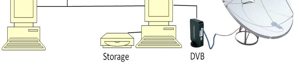
34 System layout


35 Ground receiving components Two PCs are recommended -one for the DVB acquisition and a second for processing applications. Digital Video Broadcasting Board EUMETCast Client Software EUMETCast Key Unit (EKU) Antenna, with universal V/H LNB in C-band


36 GEONETCastReception Stations at 11 Branch offices


37 Adama Bahir Dar Awassa


38 Effective use of GEONETCastdata in Branch Offices Insight Training sessions
39 Concluding remarks In Ethiopia, weather and climate risks are major determinants for water and food security of the livelihood of the population; Hence, timely and reliable weather and climate monitoring and forecasting are very crucial; In order to have reliable weather and climate monitoring as well as prediction the role of satellite data received by GEONETCast stations is indispensable; Low cost data reception system, in conjunction with free toolbox is a good alternative for weather and climate monitoring and forecasting to provide trustworthy information to various Ethiopian regional user communities.


40 Thank you very much for your attention!
Status of EUMETSAT Operational Services & EUMETCast Africa Dissemination Baseline Updates
 Status of EUMETSAT Operational Services & EUMETCast Africa Dissemination Baseline Updates Sally Wannop User Relations Manager 1 8th WMO RAIDEG meeting 1-2 November 2017 # 951881 Overview EUMETCast Overview
Report. Northern Africa. RAIDEG-8, 1-2 Nov 2017
 Report Northern Africa RAIDEG-8, 1-2 Nov 2017 Report Northern Africa RAIDEG-8, 1-2 Nov 2017 Important Note: Formal letters have been sent from the PR of Morocco with WMO to PRs of Algeria, Tunisia, Libya
MSG system over view
 MSG system over view 1 Introduction METEOSAT SECOND GENERATION Overview 2 MSG Missions and Services 3 The SEVIRI Instrument 4 The MSG Ground Segment 5 SAF Network 6 Conclusions METEOSAT SECOND GENERATION
The use of Direct Broadcast Processing System in Poland
 The use of Direct Broadcast Processing System in Poland B.Łapeta, P.Struzik Satellite Remote Sensing Department, Institute of Meteortology and Water Management National Reasearch Institute About IMWM-NRI
The National Meteorological Services Agency Satellite Data reception and processing unit First phase by Yitaktu Tesfatsion
 The National Meteorological Services Agency Satellite Data reception and processing unit First phase by Yitaktu Tesfatsion In Ethiopia the rain guage network is not evenly distributed over the country.
Detection and Monitoring Convective Storms by. Using MSG SEVIRI Image. Aydın Gürol ERTÜRK. Contents
 Detection and Monitoring Convective Storms by 1 Using MSG SEVIRI Image Contents MSGView Software Cold U/V and Ring Shape Storm Tops Case Study, 2nd April 2011 Antalya, Türkiye Conclusion Aydın Gürol ERTÜRK
New possibilities for access and utilisation of EUMETSAT data and products through DAWBEE programme
 See discussions, stats, and author profiles for this publication at: https://www.researchgate.net/publication/273637605 New possibilities for access and utilisation of EUMETSAT data and products through
Dissemination of Global Products from EUMETSAT
 Dissemination of Global Products from EUMETSAT Simon Elliott EUMETSAT simon.elliott@eumetsat.int Beijing, 23 May - 1 June 2005 Slide 1 Overview NRT Replaced by EUMETCast What is EUMETCast? Which data sets
EUMETSAT SAF NETWORK. Lothar Schüller, EUMETSAT SAF Network Manager
 1 EUMETSAT SAF NETWORK Lothar Schüller, EUMETSAT SAF Network Manager EUMETSAT ground segment overview METEOSAT JASON-2 INITIAL JOINT POLAR SYSTEM METOP NOAA SATELLITES CONTROL AND DATA ACQUISITION FLIGHT
PRECONVECTIVE SOUNDING ANALYSIS USING IASI AND MSG- SEVIRI
 PRECONVECTIVE SOUNDING ANALYSIS USING IASI AND MSG- SEVIRI Marianne König, Dieter Klaes EUMETSAT, Eumetsat-Allee 1, 64295 Darmstadt, Germany Abstract EUMETSAT operationally generates the Global Instability
Atmospheric Motion Vectors: Product Guide
 Atmospheric Motion Vectors: Product Guide Doc.No. Issue : : EUM/TSS/MAN/14/786435 v1a EUMETSAT Eumetsat-Allee 1, D-64295 Darmstadt, Germany Tel: +49 6151 807-7 Fax: +49 6151 807 555 Date : 9 April 2015
EUMETSAT s Support to Climate Services and User Support. Joachim Saalmüller
 EUMETSAT s Support to Climate Services and User Support Joachim Saalmüller 1 User Forum in Africa September 2016 Outline of my talk EUMETSAT in support of climate services Exploring our data and subscribing
MSGVIEW: AN OPERATIONAL AND TRAINING TOOL TO PROCESS, ANALYZE AND VISUALIZATION OF MSG SEVIRI DATA
 MSGVIEW: AN OPERATIONAL AND TRAINING TOOL TO PROCESS, ANALYZE AND VISUALIZATION OF MSG SEVIRI DATA Aydın Gürol Ertürk Turkish State Meteorological Service, Remote Sensing Division, CC 401, Kalaba Ankara,
NWC-SAF Satellite Application Facility in Support to Nowcasting and Very Short Range Forecasting
 NWC-SAF Satellite Application Facility in Support to Nowcasting and Very Short Range Forecasting Marianne König Slide 1 Satellite Application Facilities (SAFs) in Europe Member State Cooperating State
INTERPRETATION OF MSG IMAGES, PRODUCTS AND SAFNWC OUTPUTS FOR DUTY FORECASTERS
 INTERPRETATION OF MSG IMAGES, PRODUCTS AND SAFNWC OUTPUTS FOR DUTY FORECASTERS M. Putsay, M. Rajnai, M. Diószeghy, J. Kerényi, I.G. Szenyán and S. Kertész Hungarian Meteorological Service, H-1525 Budapest,
EUMETSAT REPORT ON GEONETCAST
 Prepared by EUMETSAT Agenda Item: WGIV/5 Discussed in WGIV EUMETSAT REPORT ON GEONETCAST GEONETCast, which consists of a network of three dissemination systems - GEONETCast Americas operated by NOAA, FENGYUNCast
Use of satellite information in research and operational activities at NIMH of Bulgaria
 Use of satellite information in research and operational activities at NIMH of Bulgaria Rilka Valcheva NIMH, Bulgaria WMO/EUMETSAT Satellite Products Training Course 24-28 April 2017, Budapest, Hungary
Himawari 8/9 data distribution/dissemination plan
 Himawari 8/9 data distribution/dissemination plan Japan Meteorological Agency (JMA) Hidehiko MURATA Himawari is the name of this flower in Japanese ET SUP 8, WMO HQ, Geneva, 14 17 April 2014 1 Outline
USE OF SATELLITE INFORMATION IN THE HUNGARIAN NOWCASTING SYSTEM
 USE OF SATELLITE INFORMATION IN THE HUNGARIAN NOWCASTING SYSTEM Mária Putsay, Zsófia Kocsis and Ildikó Szenyán Hungarian Meteorological Service, Kitaibel Pál u. 1, H-1024, Budapest, Hungary Abstract The
OPERATIONAL USE OF METEOSAT-8 SEVIRI DATA AND DERIVED NOWCASTING PRODUCTS. Nataša Strelec Mahović
 OPERATIONAL USE OF METEOSAT-8 SEVIRI DATA AND DERIVED NOWCASTING PRODUCTS Nataša Strelec Mahović Meteorological and Hydrological Service Grič 3, 10 000 Zagreb, Croatia strelec@cirus.dhz.hr ABSTRACT Meteosat-8
THE LAND-SAF SURFACE ALBEDO AND DOWNWELLING SHORTWAVE RADIATION FLUX PRODUCTS
 THE LAND-SAF SURFACE ALBEDO AND DOWNWELLING SHORTWAVE RADIATION FLUX PRODUCTS Bernhard Geiger, Dulce Lajas, Laurent Franchistéguy, Dominique Carrer, Jean-Louis Roujean, Siham Lanjeri, and Catherine Meurey
REPORT ON GEONETCAST In response to CGMS action/recommendation
 Prepared by EUMETSAT Agenda Item: G.2 Discussed in Plenary, WGI, WGII, WGIII, WGIV REPORT ON GEONETCAST In response to CGMS action/recommendation GEONETCast, which consists of a network of three dissemination
MSG Indian Ocean Data Coverage (IODC) Jochen Grandell & Sauli Joro
 Jochen Grandell & Sauli Joro") MSG Indian Ocean Data Coverage (IODC) Jochen Grandell & Sauli Joro 1 EUM/STG-SWG/42/17/VWG/03 v1, 7 8 Mach 2017 Topics Introduction MSG-IODC Overall Project Schedule Status Product validation Products
MSG Indian Ocean Data Coverage (IODC) Jochen Grandell & Sauli Joro 1 EUM/STG-SWG/42/17/VWG/03 v1, 7 8 Mach 2017 Topics Introduction MSG-IODC Overall Project Schedule Status Product validation Products
1 5 th RAIDEG PUMA 2010 Upgrade - EUM/OPS/VWG/14/ September 2014 PUMA-2010 UPGRADE
 1 5 th RAIDEG PUMA 2010 Upgrade - EUM/OPS/VWG/14/770918-6 September 2014 PUMA-2010 UPGRADE Category Product Title Format Consolidation of MDD stream, change of channel, no LRIT wrapping, use of wmo filenames
SAFNWC/MSG SEVIRI CLOUD PRODUCTS
 SAFNWC/MSG SEVIRI CLOUD PRODUCTS M. Derrien and H. Le Gléau Météo-France / DP / Centre de Météorologie Spatiale BP 147 22302 Lannion. France ABSTRACT Within the SAF in support to Nowcasting and Very Short
Evapotranspiration monitoring with Meteosat Second Generation satellites: method, products and utility in drought detection.
 Evapotranspiration monitoring with Meteosat Second Generation satellites: method, products and utility in drought detection. Nicolas Ghilain Royal Meteorological Institute Belgium EUMeTrain Event week
EUMETSAT SAF NETWORK. Lothar Schüller, EUMETSAT SAF Network Manager
 1 EUMETSAT SAF NETWORK Lothar Schüller, EUMETSAT SAF Network Manager EUMETSAT ground segment overview METEOSAT JASON-2 INITIAL JOINT POLAR SYSTEM METOP NOAA SATELLITES CONTROL AND DATA ACQUISITION FLIGHT
LAND SURFACE ALBEDO AND DOWNWELLING SHORTWAVE RADIATION FROM MSG GEOSTATIONARY SATELLITE (METHOD FOR RETRIEVAL, VALIDATION, AND APPLICATION)
") LAND SURFACE ALBEDO AND DOWNWELLING SHORTWAVE RADIATION FROM MSG GEOSTATIONARY SATELLITE (METHOD FOR RETRIEVAL, VALIDATION, AND APPLICATION) Dominique Carrer, Jean-Louis Roujean, Olivier Hautecoeur, Jean-Christophe
LAND SURFACE ALBEDO AND DOWNWELLING SHORTWAVE RADIATION FROM MSG GEOSTATIONARY SATELLITE (METHOD FOR RETRIEVAL, VALIDATION, AND APPLICATION) Dominique Carrer, Jean-Louis Roujean, Olivier Hautecoeur, Jean-Christophe
Time Series Analysis with SAR & Optical Satellite Data
 Time Series Analysis with SAR & Optical Satellite Data Thomas Bahr ESRI European User Conference Thursday October 2015 harris.com Motivation Changes in land surface characteristics mirror a multitude of
Applications of multi-spectral satellite data
 Applications of multi-spectral satellite data Jochen Kerkmann EUMETSAT, Satellite Meteorologist, Training Officer Adjusted by E de Coning South African Weather Service Content 1. Why should we use RGBs?
STATUS OF JAPANESE METEOROLOGICAL SATELLITES AND RECENT ACTIVITIES OF MSC
 STATUS OF JAPANESE METEOROLOGICAL SATELLITES AND RECENT ACTIVITIES OF MSC Daisaku Uesawa Meteorological Satellite Center, Japan Meteorological Agency Abstract MTSAT-1R is the current operational Japanese
Space technologies for meteorological extreme events forecast and monitoring in Romania
 Space technologies for meteorological extreme events forecast and monitoring in Romania Dr. Ion SANDU Dr. Gheorghe STANCALIE National Meteorological Administration Bucharest, Romania Contents: Introduction
"Experiences with use of EUMETSAT MPEF GII product for convection/storm nowcasting"
 "Experiences with use of EUMETSAT MPEF GII product for convection/storm nowcasting" Marianne König 1, Monika Pajek 2, Piotr Struzik 2 1) EUMETSAT 2) Institute of Meteorology and Water Management, Kraków,
RAIDEG7 and GFCS needs. Mariane Diop Kane Chair of RAIDEG Director of Meteorology, ANACIM
 RAIDEG7 and GFCS needs Mariane Diop Kane Chair of RAIDEG Director of Meteorology, ANACIM RA-I Dissemination Expert Group (RAIDEG) Established in 2010 by WMO, in cooperation with EUMETSAT Endorsed by WMO
How to display RGB imagery by SATAID
 How to display RGB imagery by SATAID Akihiro SHIMIZU Meteorological Satellite Center (MSC), Japan Meteorological Agency (JMA) Ver. 2015110500 RGB imagery on SATAID SATAID software has a function of overlapping
Copernicus Global Land Service
 Copernicus Global Land Service Cryosphere Products Kari Luojus on behalf the consortium Follow us on: Copernicus EU CopernicusEU www.copernicus.eu Copernicus Services Land Marine Atmosphere Emergency Security
SEVIRI - Cloud Top Height Factsheet
 Doc.No. : EUM/OPS/DOC/11/4199 Issue : v2a Date : 28 December 2011 WBS : EUMETSAT Eumetsat-Allee 1, D-64295 Darmstadt, Germany Tel: +49 6151 807-7 Fax: +49 6151 807 555 http://www.eumetsat.int EUMETSAT
European Drought Observatory Progress on Drought Monitoring
 European Drought Observatory Progress on Drought Monitoring Alfred de Jager Diego Magni European Commission Joint Research Centre (JRC) Disaster Risk Management Unit Outline 1. Introduction Philosophy
Overview of Himawari-8/9
 Overview of Himawari-8/9 Toshiyuki SAKURAI Meteorological Satellite Center (MSC) Japan Meteorological Agency (JMA) EUMeTrain Event Week on MTG-I Satellite 2016 Session2 - Himawari-8 and Data Applications
Dissemination of global products from Metop
 Dissemination of global products from Metop Simon S. Elliott EUMETSAT Operations Department, Darmstadt, Germany Introduction From an early stage in the commissioning of Metop, EUMETSAT will distribute
REPORT ON EUMETCAST INCLUDING GEONETCAST
 Prepared by EUMETSAT Agenda Item: F.2 Discussed in Plenary REPORT ON EUMETCAST INCLUDING GEONETCAST This paper presents the actual status of the system architecture, data services supported, and registration
Product User Manual for Cloud. Products (CMa-PGE01 v3.2, CT-
 Page: 1/34 Product User Manual for Cloud SAF/NWC/CDOP2/MFL/SCI/PUM/01, Issue 3, Rev. 2.3 4 December 2014 Applicable to SAFNWC/MSG version 2013 Prepared by Météo-France / Centre de Météorologie Spatiale
eport Nataša Strelec Mahović Meteorological and Hydrological Service, Grič 3, Zagreb, Croatia EUMeTrain project Abstract
 eport Nataša Strelec Mahović Meteorological and Hydrological Service, Grič 3, Zagreb, Croatia EUMeTrain project Abstract The paper presents the concept of eport, an interface enabling the combined analysis
School on Modelling Tools and Capacity Building in Climate and Public Health April Remote Sensing
 2453-5 School on Modelling Tools and Capacity Building in Climate and Public Health 15-26 April 2013 Remote Sensing CECCATO Pietro International Research Institute for Climate and Society, IRI The Earth
H-SAF future developments on Convective Precipitation Retrieval
 H-SAF future developments on Convective Precipitation Retrieval Francesco Zauli 1, Daniele Biron 1, Davide Melfi 1, Antonio Vocino 1, Massimiliano Sist 2, Michele De Rosa 2, Matteo Picchiani 2, De Leonibus
1 Introduction. Station Type No. Synoptic/GTS 17 Principal 172 Ordinary 546 Precipitation
 Use of Automatic Weather Stations in Ethiopia Dula Shanko National Meteorological Agency(NMA), Addis Ababa, Ethiopia Phone: +251116639662, Mob +251911208024 Fax +251116625292, Email: Du_shanko@yahoo.com
ATMOSPHERIC MOTION VECTORS DERIVED FROM MSG RAPID SCANNING SERVICE DATA AT EUMETSAT
 ATMOSPHERIC MOTION VECTORS DERIVED FROM MSG RAPID SCANNING SERVICE DATA AT EUMETSAT Manuel Carranza 1, Arthur de Smet 2, Jörgen Gustafsson 2 1 GMV Aerospace and Defence S.A. at EUMETSAT, Eumetsat-Allee
EUMETSAT LSA-SAF EVAPOTRANSPIRATION PRODUCTS STATUS AND PERSPECTIVES
 EUMETSAT LSA-SAF EVAPOTRANSPIRATION PRODUCTS STATUS AND PERSPECTIVES Arboleda, N. Ghilain, F. Gellens-Meulenberghs Royal Meteorological Institute, Avenue Circulaire, 3, B-1180 Bruxelles, BELGIUM Corresponding
MAIN ATTRIBUTES OF THE PRECIPITATION PRODUCTS DEVELOPED BY THE HYDROLOGY SAF PROJECT RESULTS OF THE VALIDATION IN HUNGARY
 MAIN ATTRIBUTES OF THE PRECIPITATION PRODUCTS DEVELOPED BY THE HYDROLOGY SAF PROJECT RESULTS OF THE VALIDATION IN HUNGARY Eszter Lábó OMSZ-Hungarian Meteorological Service, Budapest, Hungary labo.e@met.hu
Comparison of MSG-SEVIRI and SPOT-VEGETATION data for vegetation monitoring over Africa
 Comparison of MSG-SEVIRI and SPOT-VEGETATION data for vegetation monitoring over Africa Bernard LACAZE CNRS UMR 8586 PRODIG Pôle Image et Campus Spatial, Université Paris Diderot Paris 7 Objectives Comparison
DRARS Coordination Meeting Contribution from IMD
 DRARS Coordination Meeting Contribution from IMD Dr. Ashim Kumar Mitra Ministry of Earth Sciences India Meteorological Department New Delhi-INDIA 11-13 March 2015 The Processing System of NOAA/METOP/MODIS
Steve Colwell. British Antarctic Survey
 Global Climate Observing System (GCOS) Steve Colwell British Antarctic Survey Goal and Structure of GCOS The Goal of GCOS is to provide continuous, reliable, comprehensive data and information on the state
WAFS_Word. 2. Menu. 2.1 Untitled Slide
 WAFS_Word 2. Menu 2.1 Untitled Slide Published by Articulate Storyline 1. Introduction 1.1 Introduction Notes: As you will probably be aware, the traditional significant weather forecasts, usually seen
EARS-ATMS, EARS-CrIS and EARS-VIIRS: Three New Regional Services
 EARS-, EARS- and EARS-VIIRS: Three New Regional Services Anders Meier Soerensen, Ester Rojo, Thomas Heinemann, Michele Burla, Susanne Dieterle EUMETSAT Monitoring weather and climate from space Meteosat-7
Validation Report for Precipitation products from Cloud Physical Properties (PPh-PGE14: PCPh v1.0 & CRPh v1.0)
") Page: 1/26 Validation Report for Precipitation SAF/NWC/CDOP2/INM/SCI/VR/15, Issue 1, Rev. 0 15 July 2013 Applicable to SAFNWC/MSG version 2013 Prepared by AEMET Page: 2/26 REPORT SIGNATURE TABLE Function
Page: 1/26 Validation Report for Precipitation SAF/NWC/CDOP2/INM/SCI/VR/15, Issue 1, Rev. 0 15 July 2013 Applicable to SAFNWC/MSG version 2013 Prepared by AEMET Page: 2/26 REPORT SIGNATURE TABLE Function
INTRODUCTION OF THE RECURSIVE FILTER FUNCTION IN MSG MPEF ENVIRONMENT
 INTRODUCTION OF THE RECURSIVE FILTER FUNCTION IN MSG MPEF ENVIRONMENT Gregory Dew EUMETSAT Abstract EUMETSAT currently uses its own Quality Index (QI) scheme applied to wind vectors derived from the Meteosat-8
Land Surface Temperature in the EUMETSAT LSA SAF: Current Service and Perspectives. Isabel Trigo
 Land Surface Temperature in the EUMETSAT LSA SAF: Current Service and Perspectives Isabel Trigo Outline EUMETSAT Land-SAF: Land Surface Temperature Geostationary Service SEVIRI Polar-Orbiter AVHRR/Metop
Country Report - Singapore
 Country Report - Singapore The 5th Meeting of the Coordinating Group Vladivostok city, Russky Island, Russia Far Eastern Federal University of the RA II WIGOS Satellite Project 21 October 2017 Outline
Combined and parallel use of MSG composite images and SAFNWC/MSG products at the Hungarian Meteorological Service
 Combined and parallel use of MSG composite images and SAFNWC/MSG products at the Hungarian Meteorological Service Mária Putsay, Kornél Kolláth and Ildikó Szenyán Hungarian Meteorological Service H-1525
Benefits of the new-generation Himawari-8 geostationary satellite for the Asia-Pacific region. Toshihiko HASHIDA Japan Meteorological Agency (JMA)
") Benefits of the new-generation Himawari-8 geostationary satellite for the Asia-Pacific region Toshihiko HASHIDA Japan Meteorological Agency (JMA) Side Event Ensuring User Readiness to New-Generation Meteorological
Benefits of the new-generation Himawari-8 geostationary satellite for the Asia-Pacific region Toshihiko HASHIDA Japan Meteorological Agency (JMA) Side Event Ensuring User Readiness to New-Generation Meteorological
István Ihász, Hungarian Meteorological Service, Budapest, Hungary
 Experiences using VarEPS products at the Hungarian Meteorological Service István Ihász, Hungarian Meteorological Service, Budapest, Hungary 1 Introduction ECMWF 15 day Variable Resolution Ensemble Prediction
A Facility for Producing Consistent Remotely Sensed Biophysical Data Products of Australia
 TERRESTRIAL ECOSYSTEM RESEARCH NETWORK - AusCover - A Facility for Producing Consistent Remotely Sensed Biophysical Data Products of Australia June, 2011 Mervyn Lynch Professor of Remote Sensing Curtin
TAMSAT: LONG-TERM RAINFALL MONITORING ACROSS AFRICA
 TAMSAT: LONG-TERM RAINFALL MONITORING ACROSS AFRICA Ross Maidment, Emily Black, Matthew Young and Dagmawi Asfaw TAMSAT, University of Reading Helen Greatrex IRI, Columbia University 13 th EUMETSAT User
MONITORING WEATHER AND CLIMATE FROM SPACE
 MONITORING WEATHER AND CLIMATE FROM SPACE EUMETSAT Report on New Services Anders Meier Soerensen New X/L-band antenna, Greenland Athens: New 3.0 m L/X-band antenna New 2.4 m L/Xband antenna Installations
Status and Plans of Next Generation Japanese Geostationary Meteorological Satellites Himawari 8/9
 Status and Plans of Next Generation Japanese Geostationary Meteorological Satellites Himawari 8/9 Masahiro Hayashi 1, Kotaro Bessho 1, and Tomoo Ohno 2 1: JMA/Meteorological Satellite Center (MSC) 2: JMA/Satellite
Opportunities of the Low-Cost Satellite Image Reception Station Established at GIS & RS Center of Bahir Dar University, Institute of Technology
 Opportunities of the Low-Cost Satellite Image Reception Station Established at GIS & RS Center of Bahir Dar University, Institute of Technology Abeyou W. a, Mengeste A. a, Workaferahu A. b, Mulken M. c,
SATELLITE MONITORING OF THE CONVECTIVE STORMS
 SATELLITE MONITORING OF THE CONVECTIVE STORMS FORECASTERS POINT OF VIEW Michaela Valachová, EUMETSAT Workshop at ECMWF User Meeting Reading, 13 June 2017 Central Forecasting Office, Prague michaela.valachova@chmi.cz
MONITORING THE ATMOSPHERE, OCEAN AND CLIMATE FROM SPACE
 MONITORING THE ATMOSPHERE, OCEAN AND CLIMATE FROM SPACE TRANSFORMING OUR WORLD MONITORING WEATHER AND CLIMATE FROM SPACE MONITORING THE ATMOSPHERE, OCEAN AND CLIMATE FROM SPACE FOR TRANSFORMING OUR WORLD
Available data and products for Agricultural purpose at the National Meteorological Agency of Ethiopia
 Available data and products for Agricultural purpose at the National Meteorological Agency of Ethiopia NSF-PIRE KICKOFF CONFERENCE, JULY 11-12 DELANO HOTEL, BAHIR DAR By Melesse Lemma National Meteorological
Climate Change Service
 Service Metadata for the Data Store Dick Dee, ECMWF C3S: data + expertise + operational Open and free access to climate data (observations, reanalyses, model predictions) Tools and best scientific practices
MSG FOR NOWCASTING - EXPERIENCES OVER SOUTHERN AFRICA
 MSG FOR NOWCASTING - EXPERIENCES OVER SOUTHERN AFRICA Estelle de Coning and Marianne König South African Weather Service, Private Bag X097, Pretoria 0001, South Africa EUMETSAT, Am Kavalleriesand 31, D-64295
GSCB Workshop 2009: EUMETSAT Missions
 GSCB Workshop 2009: EUMETSAT Missions Dr. Harald Rothfuss, EUMETSAT. GSCB Workshop 2007, ESRIN, Frascati, 18-19 June 2009. Slide: 1 Introduction To EUMETSAT The European Organisation for the Exploitation
Follow-up to WMO 2012 Survey on the Use of Satellite Data: Feedback by RA I Members
 WMO Follow-up to WMO 2012 Survey on the Use of Satellite Data: Feedback by RA I Members Gillie Cheelo-Intern WMO Space Programme World Meteorological Organization (WMO) WMO; Observation and Information
Some NOAA Products that Address PSTG Satellite Observing Requirements. Jeff Key NOAA/NESDIS Madison, Wisconsin USA
 Some NOAA Products that Address PSTG Satellite Observing Requirements Jeff Key NOAA/NESDIS Madison, Wisconsin USA WMO Polar Space Task Group, 4 th meeting, Greenbelt, 30 September 2014 Relevant Missions
GFAS Methodology & Results
 GFAS Methodology & Results Johannes W. Kaiser, Imke Hüser, Berit Gehrke Max Planck Institute for Chemistry, DE Tadas Nikonovas, Weidong Xu, Martin G. Wooster King s College London, UK Ioannis Bistinas,
Data Format and Visualization Agenda
 Data Format and Visualization Agenda- 7.2.2 ET-SUP-8 (14.04.2014) Suman Goyal, Satellite Meteorology Division, India Meteorological Department, Suman_goyal61@yahoo.co.in Visualization Methods The satellite
RGB Experts and Developers Workshop - Introduction Tokyo, Japan 7-9 Nov 2017
 RGB Experts and Developers Workshop - Introduction Tokyo, Japan 7-9 Nov 2017 Workshop Objectives Review of existing RGB standards Reconfirm and extend existing standards (new multi-spectral imagers) Stimulate
Observations needed for verification of additional forecast products
 Observations needed for verification of additional forecast products Clive Wilson ( & Marion Mittermaier) 12th Workshop on Meteorological Operational Systems, ECMWF, 2-6 November 2009 Additional forecast
JMA s ATMOSPHERIC MOTION VECTORS In response to Action 40.22
 5 July 2013 Prepared by JMA Agenda Item: II/6 Discussed in WG II JMA s ATMOSPHERIC MOTION VECTORS In response to Action 40.22 This paper reports on the recent status of JMA's AMVs from MTSAT-2 and MTSAT-1R,
Results from the ARM Mobile Facility
 AMMA Workshop, Toulouse, November 2006 Results from the ARM Mobile Facility Background Anthony Slingo Environmental Systems Science Centre University of Reading, UK Selected results, including a major
Polar Multi-Sensor Aerosol Product: User Requirements
 Polar Multi-Sensor Aerosol Product: User Requirements Doc.No. Issue : : EUM/TSS/REQ/13/688040 v2 EUMETSAT EUMETSAT Allee 1, D-64295 Darmstadt, Germany Tel: +49 6151 807-7 Fax: +49 6151 807 555 Telex: 419
Cloud Top Height Product: Product Guide
 Cloud Top Height Product: Product Guide Doc.No. : Issue : v1c e-signed Date : 26 April 2017 WBS : EUM/TSS/MAN/14/786420 EUMETSAT Eumetsat-Allee 1, D-64295 Darmstadt, Germany Tel: +49 6151 807-7 Fax: +49
Meteorological Service of Canada Perspectives. WMO Coordination Group on Satellite Data Requirements for RAIII/IV
 Meteorological Service of Canada Perspectives presented to the WMO Coordination Group on Satellite Data Requirements for RAIII/IV David Bradley Meteorological Service of Canada Environment Canada April
Model enhancement & delivery plans, RAI
 Model enhancement & delivery plans, RAI Karen McCourt, UK VCP Manager 12 th June 2013 Outline Current model outputs & dissemination Future model outputs & dissemination New website for dissemination to
Regional Flash Flood Guidance and Early Warning System
 WMO Training for Trainers Workshop on Integrated approach to flash flood and flood risk management 24-28 October 2010 Kathmandu, Nepal Regional Flash Flood Guidance and Early Warning System Dr. W. E. Grabs
The water vapour channels of SEVIRI (Meteosat). An introduction
. An introduction") The water vapour channels of SEVIRI (Meteosat). An introduction jose.prieto@eumetsat.int Cachoeira P. July 2006 Formats 1.5 1 Objectives 2 Describe the characteristics of WV channels on board of SEVIRI
The water vapour channels of SEVIRI (Meteosat). An introduction jose.prieto@eumetsat.int Cachoeira P. July 2006 Formats 1.5 1 Objectives 2 Describe the characteristics of WV channels on board of SEVIRI
QUALITY OF MPEF DIVERGENCE PRODUCT AS A TOOL FOR VERY SHORT RANGE FORECASTING OF CONVECTION
 QUALITY OF MPEF DIVERGENCE PRODUCT AS A TOOL FOR VERY SHORT RANGE FORECASTING OF CONVECTION C.G. Georgiev 1, P. Santurette 2 1 National Institute of Meteorology and Hydrology, Bulgarian Academy of Sciences
Workstations at Met Éireann. Kieran Commins Head Applications Development
 Workstations at Met Éireann Kieran Commins Head Applications Development Background For many years Met Éireann has used several systems for visualisation of data X-charts for NWP Intranet for Satellite/radar
An Overview of the UW Hyperspectral Retrieval System for AIRS, IASI and CrIS
 An Overview of the UW Hyperspectral Retrieval System for AIRS, IASI and CrIS Nadia Smith a, Elisabeth Weisz b and William L. Smith Cooperative Institute for Meteorological Satellite Studies (CIMSS) Space
Preparation for Himawari 8
 Preparation for Himawari 8 Japan Meteorological Agency Meteorological Satellite Center Hidehiko MURATA ET SUP 8, WMO HQ, Geneva, 14 17 April 2014 1/18 Introduction Background The Japan Meteorological Agency
H SAF SATELLITE APPLICATION FACILITY ON SUPPORT TO OPERATIONAL HYDROLOGY AND WATER MANAGEMENT EUMETSAT NETWORK OF SATELLITE APPLICATION FACILITIES
 H SAF SATELLITE APPLICATION FACILITY ON SUPPORT TO OPERATIONAL HYDROLOGY AND WATER MANAGEMENT EUMETSAT NETWORK OF SATELLITE APPLICATION FACILITIES H-SAF: SATELLITE PRODUCTS FOR OPERATIONAL HYDROLOGY H-SAF
LANDSAF SNOW COVER MAPPING USING MSG/SEVIRI DATA
 LANDSAF SNOW COVER MAPPING USING MSG/SEVIRI DATA Niilo Siljamo and Otto Hyvärinen Finnish Meteorological Institute, Erik Palménin aukio 1, P.O.Box 503, FI-00101 Helsinki, Finland Abstract Land Surface
EUMETSAT products and services for monitoring storms - New missions, more data and more meteorological products
 EUMETSAT products and services for monitoring storms - New missions, more data and more meteorological products Jochen Grandell 1 EUM/RSP/VWG/17/921460 Outline Overview of EUMETSAT missions Current...and
JMA s atmospheric motion vectors
 Prepared by JMA Agenda Item: WG II/6 Discussed in WG II JMA s atmospheric motion vectors This paper reports on the recent status of JMA's Atmospheric Motion Vectors (AMVs) from MTSAT-2 and MTSAT-1R, and
DATA BROWSING AND ANALYSIS TOOL FOR MTSAT/LRIT. Ryoji Kumabe
 DATA BROWSING AND ANALYSIS TOOL FOR MTSAT/LRIT Ryoji Kumabe Meteorological Satellite Center / Japan Meteorological Agency 3-235 Nakakiyoto Kiyose Tokyo, Japan ABSTRACT The Multi-functional Transport Satellite
ECNU WORKSHOP LAB ONE 2011/05/25)
") ECNU WORKSHOP LAB ONE (Liam.Gumley@ssec.wisc.edu 2011/05/25) The objective of this laboratory exercise is to become familiar with the characteristics of MODIS Level 1B 1000 meter resolution data. After
ECNU WORKSHOP LAB ONE (Liam.Gumley@ssec.wisc.edu 2011/05/25) The objective of this laboratory exercise is to become familiar with the characteristics of MODIS Level 1B 1000 meter resolution data. After
Evaluation of land surface temperature (LST) patterns in the urban agglomeration of Krakow using different satellite data and GIS
 patterns in the urban agglomeration of Krakow using different satellite data and GIS") Evaluation of land surface temperature (LST) patterns in the urban agglomeration of Krakow using different satellite data and GIS Jakub P. Walawender 1,2 1 Satellite Remote Sensing Centre, Institute of
Evaluation of land surface temperature (LST) patterns in the urban agglomeration of Krakow using different satellite data and GIS Jakub P. Walawender 1,2 1 Satellite Remote Sensing Centre, Institute of
6 th ET SAT meeting, April 12 15, Geneva, Switzerland Satellite Programme of KMA
 6 th ET SAT meeting, April 12 15, Geneva, Switzerland Satellite Programme of KMA Korea Meteorological Administration National Meteorological Satellite Center Status of COMS COMS Heritage COM Design & Review
WMO Coordination Group on Satellite Data Requirements for Region III and IV Sept 5-8, 2016 Willemstad, Curaçao
 WMO Coordination Group on Satellite Data Requirements for Region III and IV Sept 5-8, 2016 Willemstad, Curaçao 1. Current Satellite Reception 2. Preparation for Next-Gen GOES-R JPSS 3. Satellite Data Applications
REPRESENTING EUMETSAT S ACTIVE FIRE MONITORING PRODUCT BY GOOGLE EARTH OVER TURKEY
 REPRESENTING EUMETSAT S ACTIVE FIRE MONITORING PRODUCT BY GOOGLE EARTH OVER TURKEY Ahmet Emre TEKELİ 1, İbrahim SÖNMEZ 1, Erdem ERDİ 1, Fatih DEMİR 1, Murat ARSLAN 1, Meral L. ÇUKURÇAYIR 1, Hakan KOÇAK