Results from the ARM Mobile Facility
|
|
|
- Liliana Russell
- 5 years ago
- Views:
Transcription
1 AMMA Workshop, Toulouse, November 2006 Results from the ARM Mobile Facility Background Anthony Slingo Environmental Systems Science Centre University of Reading, UK Selected results, including a major dust storm in March 2006 Summary and future work
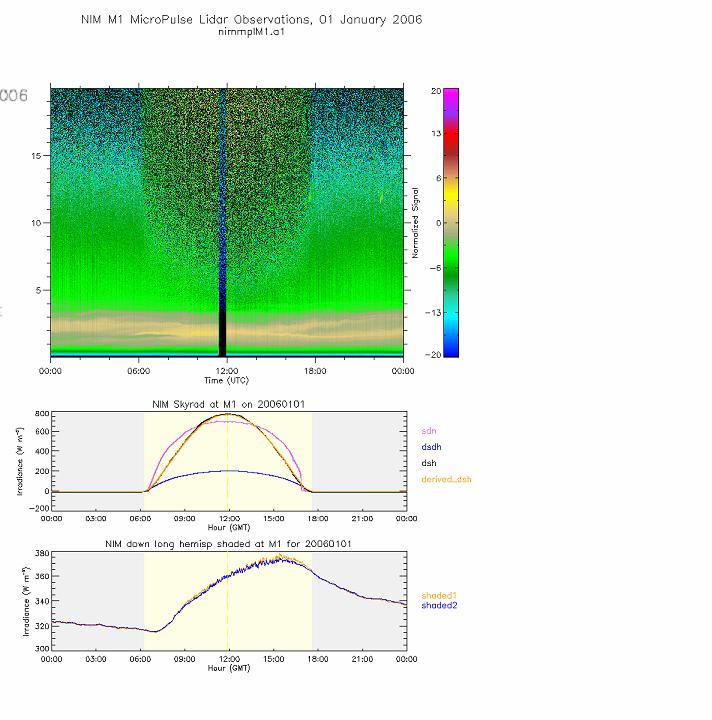
2 ARM Mobile Facility The AMF is operated by the US Atmospheric Radiation Measurement (ARM) program It was established in November 2005 and will continue to run until the end of 2006 the main site is at Niamey airport subsidiary site at Banizoumbou Wide range of instruments at the main site: including visible, infrared and microwave radiometers, infrared spectrometer (AERI), Lidars, Radar, aerosol sampling, standard meteorological instruments and radiosondes (four per day throughout the year)


3 Overview of the main site at Niamey airport. The instrument field (right) is located about 100m from the main facility (left)

4


5
6 The RADAGAST project Radiative Atmospheric Divergence using ARM Mobile Facility, GERB data and AMMA stations led by Tony Slingo, ESSC, Reading University, UK Links the ARM Mobile Facility with GERB (Geostationary Earth Radiation Budget instrument on Meteosat) & AMMA The objective is to derive the divergence of radiation across the atmosphere: by combining the AMF measurements of the surface radiative fluxes and vertical structure of the atmosphere with GERB data from the top of the atmosphere and AMMA observations study the radiative properties of aerosols (desert dust, biomass), water vapour and clouds provide comprehensive observations for testing radiation codes
7 SEVIRI and GERB on Meteosat SEVIRI is the operational imager 12 narrow spectral channels covering solar (4 vis/nir) and thermal (8 IR) regions sub-satellite resolution ~1km / ~3km GERB measures the broadband radiation budget shortwave and total: μm and μm subtraction results in longwave: 4-30μm sub-satellite resolution is ~45km, but there is also an enhanced resolution product (~10km) using SEVIRI Both instruments have ~15 minute temporal resolution Meteosat-8 is the operational satellite, launched August 2002 Meteosat-9 launched December 2005 is currently backup
8 Column water vapour over Niamey (cm) Green: microwave radiometer Red: radiosondes J F M A M J J A S O
9


10
11
12 Observations of the impact of a major Saharan dust storm on the atmospheric radiation balance A. Slingo 1, T.P. Ackerman 2, R.P. Allan 1, E.I. Kassianov 2, S.A. Mcfarlane 2, G.J. Robinson 1, J.C. Barnard 2, M.A. Miller 3, J.E. Harries 4, J.E. Russell 4 & S. Dewitte 5 Geophysical Research Letters, in press

13 In these false-colour images, the dust appears pink or magenta, water vapour dark blue, thick high-level clouds red-brown, thin high-level clouds almost black and surface features pale blue or purple. On 6 March, unusually strong northerly winds bring cold air at low levels over the desert, creating a broad front of dust as the air moves south. 1200GMT, 6 March 2006 The location of Niamey is marked by a cross.
, so it is forced to follow the valleys.")
14 In these false-colour images, the dust appears pink or magenta, water vapour dark blue, thick high-level clouds red-brown, thin high-level clouds almost black and surface features pale blue or purple. 1200GMT, 7 March 2006 The shallow layer of cold air cannot rise over the mountains of the central Sahara (light blue in colour), so it is forced to follow the valleys. Streaks appear where it accelerates through gaps in the topography. The dust reached Niamey at 0930 on 7 March.

15 In these false-colour images, the dust appears pink or magenta, water vapour dark blue, thick high-level clouds red-brown, thin high-level clouds almost black and surface features pale blue or purple. By 8 March, dust covers the whole of West Africa and is moving out over the Atlantic. 1200GMT, 8 March 2006
")

16 Dust product (upper) and GERB OLR (lower) for 1200UT on 8 March 2006 Cloud Dust Lake Chad
17 Animation of Meteosat dust product

18 Radiosonde ascent, 6 March 2006, prior to dust storm

19 Radiosonde ascent, 8 March 2006, during dust storm
20
21

22

23 Dust product: 1215 GMT on 6 November 2006
24 Summary and future work Excellent data from the Mobile Facility, GERB and SEVIRI overview paper in Bulletin of the American Meteorological Society ARM data are freely available: see Major dust storm in March 2006 large perturbations to solar and thermal fluxes at both the surface and at the top of the atmosphere significant increase in atmospheric solar absorption, which is underestimated by the radiation models paper in press in Geophysical Research Letters Ongoing work includes: continue to monitor events and to identify test cases quicklooks on Radagast website collaboration with Met Office (SOP0), ARM (radiative divergence), Eumetsat Climate SAF (surface radiation budget) and others developing the methodology to derive area-average surface fluxes and to exploit the data from the second site at Banizoumbou
Saharan Dust Longwave Radiative Forcing using GERB and SEVIRI
 Imperial College London Saharan Dust Longwave Radiative Forcing using GERB and SEVIRI Vincent Gimbert 1, H.E. Brindley 1, Nicolas Clerbaux 2, J.E. Harries 1 1. Blackett Laboratory, Imperial College, London
Observations of the impact of a major Saharan dust storm on the atmospheric radiation balance
 Click Here for Full Article GEOPHYSICAL RESEARCH LETTERS, VOL. 33, L24817, doi:10.1029/2006gl027869, 2006 Observations of the impact of a major Saharan dust storm on the atmospheric radiation balance A.
THE LAND-SAF SURFACE ALBEDO AND DOWNWELLING SHORTWAVE RADIATION FLUX PRODUCTS
 THE LAND-SAF SURFACE ALBEDO AND DOWNWELLING SHORTWAVE RADIATION FLUX PRODUCTS Bernhard Geiger, Dulce Lajas, Laurent Franchistéguy, Dominique Carrer, Jean-Louis Roujean, Siham Lanjeri, and Catherine Meurey
Geostationary Earth Radiation Budget Project: Status and Results
 Geostationary Earth Radiation Budget Project: Status and Results J. A. Hanafin, J. E. Harries, J. E. Russell, J. M. Futyan, H. Brindley, S. Kellock, S. Dewitte1, P. M. Allan2 Space and Atmospheric Physics,
MSG system over view
 MSG system over view 1 Introduction METEOSAT SECOND GENERATION Overview 2 MSG Missions and Services 3 The SEVIRI Instrument 4 The MSG Ground Segment 5 SAF Network 6 Conclusions METEOSAT SECOND GENERATION
Data Set Description. CM SAF Top of Atmosphere Radiation GERB Data Set
 EUMETSAT Satellite Application Facility on Climate Monitoring Data Set Description DOI: 10.5676/EUM_SAF_CM/TOA_GERB/V001 Reference Number: DataSet/Desc/CMSAF/TOA/GERB Issue/Revision Index: 1.0 1. Intent
Estimation of cloud radiative impacts over West Africa, seasonal and meridional patterns.
 Estimation of cloud radiative impacts over West Africa, seasonal and meridional patterns. Olivier Geoffroy, Dominique Bouniol, Françoise Guichard, and Florence Favot CNRM-GAME, Météo France & CNRS, Toulouse,
JOURNAL OF GEOPHYSICAL RESEARCH, VOL. 114, D00E07, doi: /2008jd010504, 2009
 JOURNAL OF GEOPHYSICAL RESEARCH, VOL. 114,, doi:10.1029/2008jd010504, 2009 Simulation of surface and top of atmosphere thermal fluxes and radiances from the radiative atmospheric divergence using the ARM
Climate & Earth System Science. Introduction to Meteorology & Climate. Chapter 05 SOME OBSERVING INSTRUMENTS. Instrument Enclosure.
 Climate & Earth System Science Introduction to Meteorology & Climate MAPH 10050 Peter Lynch Peter Lynch Meteorology & Climate Centre School of Mathematical Sciences University College Dublin Meteorology
Satellite observation of atmospheric dust
 Satellite observation of atmospheric dust Taichu Y. Tanaka Meteorological Research Institute, Japan Meteorological Agency 11 April 2017, SDS WAS: Dust observation and modeling @WMO, Geneva Dust observations
Observations of the diurnal cycle of outgoing longwave radiation from the Geostationary Earth Radiation Budget instrument
 GEOPHYSICAL RESEARCH LETTERS, VOL.???, XXXX, DOI:10.1029/, Observations of the diurnal cycle of outgoing longwave radiation from the Geostationary Earth Radiation Budget instrument Ruth E. Comer, Anthony
Observations of the diurnal cycle of outgoing longwave radiation from the Geostationary Earth Radiation Budget instrument
 GEOPHYSICAL RESEARCH LETTERS, VOL. 34, L02823, doi:10.1029/2006gl028229, 2007 Observations of the diurnal cycle of outgoing longwave radiation from the Geostationary Earth Radiation Budget instrument Ruth
STATUS AND DEVELOPMENT OF SATELLITE WIND MONITORING BY THE NWP SAF
 STATUS AND DEVELOPMENT OF SATELLITE WIND MONITORING BY THE NWP SAF Mary Forsythe (1), Antonio Garcia-Mendez (2), Howard Berger (1,3), Bryan Conway (4), Sarah Watkin (1) (1) Met Office, Fitzroy Road, Exeter,
SATELLITE OBSERVATIONS OF CLOUD RADIATIVE FORCING FOR THE AFRICAN TROPICAL CONVECTIVE REGION
 SATELLITE OBSERVATIONS OF CLOUD RADIATIVE FORCING FOR THE AFRICAN TROPICAL CONVECTIVE REGION J. M. Futyan, J. E. Russell and J. E. Harries Space and Atmospheric Physics Group, Blackett Laboratory, Imperial
MSGVIEW: AN OPERATIONAL AND TRAINING TOOL TO PROCESS, ANALYZE AND VISUALIZATION OF MSG SEVIRI DATA
 MSGVIEW: AN OPERATIONAL AND TRAINING TOOL TO PROCESS, ANALYZE AND VISUALIZATION OF MSG SEVIRI DATA Aydın Gürol Ertürk Turkish State Meteorological Service, Remote Sensing Division, CC 401, Kalaba Ankara,
REVISION OF THE STATEMENT OF GUIDANCE FOR GLOBAL NUMERICAL WEATHER PREDICTION. (Submitted by Dr. J. Eyre)
") WORLD METEOROLOGICAL ORGANIZATION Distr.: RESTRICTED CBS/OPAG-IOS (ODRRGOS-5)/Doc.5, Add.5 (11.VI.2002) COMMISSION FOR BASIC SYSTEMS OPEN PROGRAMME AREA GROUP ON INTEGRATED OBSERVING SYSTEMS ITEM: 4 EXPERT
WORLD METEOROLOGICAL ORGANIZATION Distr.: RESTRICTED CBS/OPAG-IOS (ODRRGOS-5)/Doc.5, Add.5 (11.VI.2002) COMMISSION FOR BASIC SYSTEMS OPEN PROGRAMME AREA GROUP ON INTEGRATED OBSERVING SYSTEMS ITEM: 4 EXPERT
Radiative Climatology of the North Slope of Alaska and the Adjacent Arctic Ocean
 Radiative Climatology of the North Slope of Alaska and the Adjacent Arctic Ocean C. Marty, R. Storvold, and X. Xiong Geophysical Institute University of Alaska Fairbanks, Alaska K. H. Stamnes Stevens Institute
Aprimary goal of the U.S. Department of Energy s
 THE ARM MOBILE FACILITY AND ITS FIRST INTERNATIONAL DEPLOYMENT Measuring Radiative Flux Divergence in West Africa BY MARK. A. MILLER AND ANTHONY SLINGO The ARM Mobile Facility is a transportable community
Outgoing Longwave Radiation Product: Product Guide
 Outgoing Longwave Radiation Product: Product Guide Doc.No. : EUM/OPS/DOC/09/5176 EUMETSAT Eumetsat-Allee 1, D-64295 Darmstadt, Germany Tel: +49 6151 807-7 Issue : v1e Fax: +49 6151 807 555 Date : 6 May
On Surface fluxes and Clouds/Precipitation in the Tropical Eastern Atlantic
 On Surface fluxes and Clouds/Precipitation in the Tropical Eastern Atlantic Chris Fairall, NOAA/ESRL Paquita Zuidema, RSMAS/U Miami with contributions from Peter Minnett & Erica Key AMMA Team Meeting Leeds,
GERB/CERES Comparisons Update
 GERB/CERES Comparisons Update N. Clerbaux, S. Dewitte, A. Ipe, P.-J. Baeck, A. Velazquez, I. Decoster Royal Meteorological Institute of Belgium, Department of Observations, Section Remote Sensing from
Proceedings of the 3 rd MSG RAO Workshop
 SP-619 August 2006 Proceedings of the 3 rd MSG RAO Workshop 15 June 2006 Helsinki, Finland Organisers: Organising Committee E. Oriol-Pibernat, ESA Y. Govaerts, EUMETSAT M. Pooley, EUMETSAT Publication:
(1) AEMET (Spanish State Meteorological Agency), Demóstenes 4, Málaga, Spain ABSTRACT
 AEMET (Spanish State Meteorological Agency), Demóstenes 4, Málaga, Spain ABSTRACT") COMPARISON OF GROUND BASED GLOBAL RADIATION MEASUREMENTS FROM AEMET RADIATION NETWORK WITH SIS (SURFACE INCOMING SHORTWAVE RADIATION) FROM CLIMATE MONITORING-SAF Juanma Sancho1, M. Carmen Sánchez de Cos1,
COMPARISON OF GROUND BASED GLOBAL RADIATION MEASUREMENTS FROM AEMET RADIATION NETWORK WITH SIS (SURFACE INCOMING SHORTWAVE RADIATION) FROM CLIMATE MONITORING-SAF Juanma Sancho1, M. Carmen Sánchez de Cos1,
A statistical approach for rainfall confidence estimation using MSG-SEVIRI observations
 A statistical approach for rainfall confidence estimation using MSG-SEVIRI observations Elisabetta Ricciardelli*, Filomena Romano*, Nico Cimini*, Frank Silvio Marzano, Vincenzo Cuomo* *Institute of Methodologies
Variability in Global Top-of-Atmosphere Shortwave Radiation Between 2000 And 2005
 Variability in Global Top-of-Atmosphere Shortwave Radiation Between 2000 And 2005 Norman G. Loeb NASA Langley Research Center Hampton, VA Collaborators: B.A. Wielicki, F.G. Rose, D.R. Doelling February
A satellite-based long-term Land Surface Temperature Climate Data Record
 Federal Department of Home Affairs FDHA Federal Office of Meteorology and Climatology MeteoSwiss A satellite-based long-term Land Surface Temperature Climate Data Record, Virgílio A. Bento, Frank M. Göttsche,
METEOSAT THIRD GENERATION
 METEOSAT THIRD GENERATION FACTS AND FIGURES MONITORING WEATHER AND CLIMATE FROM SPACE A HIGHLY INNOVATIVE GEOSTATIONARY SATELLITE SYSTEM FOR EUROPE AND AFRICA The Meteosat Third Generation (MTG) system
Radiative effects of desert dust on weather and climate
 UNIVERSITY OF ATHENS SCHOOL OF PHYSICS, DIVISION OF ENVIRONMENT AND METEOROLOGY ATMOSPHERIC MODELING AND WEATHER FORECASTING GROUP Radiative effects of desert dust on weather and climate Christos Spyrou,
2nd Annual CICS-MD Science Meeting November 6-7, 2013 Earth System Science Interdisciplinary Center University of Maryland, College Park, MD
 Development of Algorithms for Shortwave Radiation Budget from GOES-R R. T. Pinker, M. M. Wonsick GOES-R Algorithm Working Group Radiation Budget Application Team John A. Augustine (NOAA); Hye-Yun Kim (IMSG);
EUMETSAT products and services for monitoring storms - New missions, more data and more meteorological products
 EUMETSAT products and services for monitoring storms - New missions, more data and more meteorological products Jochen Grandell 1 EUM/RSP/VWG/17/921460 Outline Overview of EUMETSAT missions Current...and
ARM Climate Research Facility: Goals and Objectives
 ARM Climate Research Facility: Goals and Objectives Provide the national and international scientific community with the infrastructure needed for scientific research on global change Global change research
P3.24 EVALUATION OF MODERATE-RESOLUTION IMAGING SPECTRORADIOMETER (MODIS) SHORTWAVE INFRARED BANDS FOR OPTIMUM NIGHTTIME FOG DETECTION
 SHORTWAVE INFRARED BANDS FOR OPTIMUM NIGHTTIME FOG DETECTION") P3.24 EVALUATION OF MODERATE-RESOLUTION IMAGING SPECTRORADIOMETER (MODIS) SHORTWAVE INFRARED BANDS FOR OPTIMUM NIGHTTIME FOG DETECTION 1. INTRODUCTION Gary P. Ellrod * NOAA/NESDIS/ORA Camp Springs, MD
P3.24 EVALUATION OF MODERATE-RESOLUTION IMAGING SPECTRORADIOMETER (MODIS) SHORTWAVE INFRARED BANDS FOR OPTIMUM NIGHTTIME FOG DETECTION 1. INTRODUCTION Gary P. Ellrod * NOAA/NESDIS/ORA Camp Springs, MD
Meteosat Third Generation. The Future European Geostationary Meteorological Satellite
 Meteosat Third Generation The Future European Geostationary Meteorological Satellite Meteosat Third Generation Jean-Loup Bézy, Donny Aminou & Paolo Bensi Future Programmes Department, ESA Directorate of
The water vapour channels of SEVIRI (Meteosat). An introduction
. An introduction") The water vapour channels of SEVIRI (Meteosat). An introduction jose.prieto@eumetsat.int Cachoeira P. July 2006 Formats 1.5 1 Objectives 2 Describe the characteristics of WV channels on board of SEVIRI
The water vapour channels of SEVIRI (Meteosat). An introduction jose.prieto@eumetsat.int Cachoeira P. July 2006 Formats 1.5 1 Objectives 2 Describe the characteristics of WV channels on board of SEVIRI
Remote Sensing Applications for Land/Atmosphere: Earth Radiation Balance
 Remote Sensing Applications for Land/Atmosphere: Earth Radiation Balance - Introduction - Deriving surface energy balance fluxes from net radiation measurements - Estimation of surface net radiation from
Bias correction of satellite data at Météo-France
 Bias correction of satellite data at Météo-France É. Gérard, F. Rabier, D. Lacroix, P. Moll, T. Montmerle, P. Poli CNRM/GMAP 42 Avenue Coriolis, 31057 Toulouse, France 1. Introduction Bias correction at
IMPORTANCE OF SATELLITE DATA (FOR REANALYSIS AND BEYOND) Jörg Schulz EUMETSAT
 Jörg Schulz EUMETSAT") IMPORTANCE OF SATELLITE DATA (FOR REANALYSIS AND BEYOND) Jörg Schulz EUMETSAT Why satellite data for climate monitoring? Global coverage Global consistency, sometimes also temporal consistency High spatial
IMPORTANCE OF SATELLITE DATA (FOR REANALYSIS AND BEYOND) Jörg Schulz EUMETSAT Why satellite data for climate monitoring? Global coverage Global consistency, sometimes also temporal consistency High spatial
The In-Orbit Commissioning of MSG-1
 Earth Observation The In-Orbit Commissioning of MSG-1 MSG Project Team, Earth Observation Projects Department, ESA Directorate of Earth Observation, ESTEC, Noordwijk, The Netherlands 80 esa bulletin 114
Radiation balance of the Earth. 6. Earth radiation balance under present day conditions. Top of Atmosphere (TOA) Radiation balance
 Radiation balance") Radiation balance of the Earth Top of Atmosphere (TOA) radiation balance 6. Earth radiation balance under present day conditions Atmospheric radiation balance: Difference between TOA and surface radiation
Radiation balance of the Earth Top of Atmosphere (TOA) radiation balance 6. Earth radiation balance under present day conditions Atmospheric radiation balance: Difference between TOA and surface radiation
NEW CGMS BASELINE FOR THE SPACE-BASED GOS. (Submitted by the WMO Secretariat) Summary and Purpose of Document
 Summary and Purpose of Document") WORLD METEOROLOGICAL ORGANIZATION COMMISSION FOR BASIC SYSTEMS OPEN PROGRAMME AREA GROUP ON INTEGRATED OBSERVING SYSTEMS EXPERT TEAM ON SATELLITE SYSTEMS ET-SAT-7/Inf. 2 (12.III.2012) ITEM: 8.1 SEVENTH
WORLD METEOROLOGICAL ORGANIZATION COMMISSION FOR BASIC SYSTEMS OPEN PROGRAMME AREA GROUP ON INTEGRATED OBSERVING SYSTEMS EXPERT TEAM ON SATELLITE SYSTEMS ET-SAT-7/Inf. 2 (12.III.2012) ITEM: 8.1 SEVENTH
Derivation of AMVs from single-level retrieved MTG-IRS moisture fields
 Derivation of AMVs from single-level retrieved MTG-IRS moisture fields Laura Stewart MetOffice Reading, Meteorology Building, University of Reading, Reading, RG6 6BB Abstract The potential to derive AMVs
The observation of the Earth Radiation Budget a set of challenges
 The observation of the Earth Radiation Budget a set of challenges Dominique Crommelynck, Steven Dewitte, Luis Gonzalez,Nicolas Clerbaux, Alessandro Ipe, Cedric Bertrand. (Royal Meteorological Institute
Assessing the Radiative Impact of Clouds of Low Optical Depth
 Assessing the Radiative Impact of Clouds of Low Optical Depth W. O'Hirok and P. Ricchiazzi Institute for Computational Earth System Science University of California Santa Barbara, California C. Gautier
EUMETSAT PLANS. K. Dieter Klaes EUMETSAT Darmstadt, Germany
 EUMETSAT PLANS K. Dieter Klaes EUMETSAT Darmstadt, Germany 1. INTRODUCTION The European Organisation for the Exploitation of Meteorological Satellites (EUMETSAT), contributes to the World Weather Watch
Polar Weather Prediction
 Polar Weather Prediction David H. Bromwich Session V YOPP Modelling Component Tuesday 14 July 2015 A special thanks to the following contributors: Kevin W. Manning, Jordan G. Powers, Keith M. Hines, Dan
Lecture 3. Background materials. Planetary radiative equilibrium TOA outgoing radiation = TOA incoming radiation Figure 3.1
 Lecture 3. Changes in planetary albedo. Is there a clear signal caused by aerosols and clouds? Outline: 1. Background materials. 2. Papers for class discussion: Palle et al., Changes in Earth s reflectance
Exploitation of Geostationary Earth Radiation Budget data using simulations from a numerical weather prediction model: Methodology and data validation
 JOURNAL OF GEOPHYSICAL RESEARCH, VOL. 110,, doi:10.1029/2004jd005698, 2005 Exploitation of Geostationary Earth Radiation Budget data using simulations from a numerical weather prediction model: Methodology
Monitoring Sand and Dust Storms from Space
 Monitoring Sand and Dust Storms from Space for Expert Consultation on Disaster Information and Knowledge, Session 2 ICC 21 for ESCAP s RESAP and CDRR 5 9 12 October, 2017 Toshiyuki KURINO WMO Space Programme
Comparison of cloud statistics from Meteosat with regional climate model data
 Comparison of cloud statistics from Meteosat with regional climate model data R. Huckle, F. Olesen, G. Schädler Institut für Meteorologie und Klimaforschung, Forschungszentrum Karlsruhe, Germany (roger.huckle@imk.fzk.de
Lecture 4b: Meteorological Satellites and Instruments. Acknowledgement: Dr. S. Kidder at Colorado State Univ.
 Lecture 4b: Meteorological Satellites and Instruments Acknowledgement: Dr. S. Kidder at Colorado State Univ. US Geostationary satellites - GOES (Geostationary Operational Environmental Satellites) US
CONSTRUCTION OF CLOUD TRAJECTORIES AND MOTION OF CIRRUS CLOUDS AND WATER VAPOUR STRUCTURES
 CONSTRUCTION OF CLOUD TRAJECTORIES AND MOTION OF CIRRUS CLOUDS AND WATER VAPOUR STRUCTURES André SZANTAI +, Michel DESBOIS +, Laurence PICON +, Henri LAURENT *, Françoise DESALMAND + + Laboratoire de Météorologie
JOURNAL OF GEOPHYSICAL RESEARCH, VOL. 113, D00C02, doi: /2007jd009741, 2008
 Click Here for Full Article JOURNAL OF GEOPHYSICAL RESEARCH, VOL. 113,, doi:10.1029/2007jd009741, 2008 Modeled and observed atmospheric radiation balance during the West African dry season: Role of mineral
Applications of the SEVIRI window channels in the infrared.
 Applications of the SEVIRI window channels in the infrared jose.prieto@eumetsat.int SEVIRI CHANNELS Properties Channel Cloud Gases Application HRV 0.7 Absorption Scattering
A Guide to Satellite Data Appropriate for Solar Energy Applications in Ireland
 University College Dublin Satellite Data A Guide to Satellite Data Appropriate for Solar Energy Applications in Ireland Eadaoin Doddy eadaoin.doddy@ucdconnect.ie 13 January 2017 Contents 1 Satellites 1
VISION FOR THE GOS IN 2025 ( Approved by CBS-XIV and Adopted by EC LXI in June 2009)
") WORLD METEOROLOGICAL ORGANIZATION Weather Climate Water VISION FOR THE GOS IN 2025 ( Approved by CBS-XIV and Adopted by EC LXI in June 2009) PREAMBLE This Vision provides high-level goals to guide the
WORLD METEOROLOGICAL ORGANIZATION Weather Climate Water VISION FOR THE GOS IN 2025 ( Approved by CBS-XIV and Adopted by EC LXI in June 2009) PREAMBLE This Vision provides high-level goals to guide the
LAND SURFACE ALBEDO AND DOWNWELLING SHORTWAVE RADIATION FROM MSG GEOSTATIONARY SATELLITE (METHOD FOR RETRIEVAL, VALIDATION, AND APPLICATION)
") LAND SURFACE ALBEDO AND DOWNWELLING SHORTWAVE RADIATION FROM MSG GEOSTATIONARY SATELLITE (METHOD FOR RETRIEVAL, VALIDATION, AND APPLICATION) Dominique Carrer, Jean-Louis Roujean, Olivier Hautecoeur, Jean-Christophe
LAND SURFACE ALBEDO AND DOWNWELLING SHORTWAVE RADIATION FROM MSG GEOSTATIONARY SATELLITE (METHOD FOR RETRIEVAL, VALIDATION, AND APPLICATION) Dominique Carrer, Jean-Louis Roujean, Olivier Hautecoeur, Jean-Christophe
PRECONVECTIVE SOUNDING ANALYSIS USING IASI AND MSG- SEVIRI
 PRECONVECTIVE SOUNDING ANALYSIS USING IASI AND MSG- SEVIRI Marianne König, Dieter Klaes EUMETSAT, Eumetsat-Allee 1, 64295 Darmstadt, Germany Abstract EUMETSAT operationally generates the Global Instability
History of Earth Radiation Budget Measurements With results from a recent assessment
 History of Earth Radiation Budget Measurements With results from a recent assessment Ehrhard Raschke and Stefan Kinne Institute of Meteorology, University Hamburg MPI Meteorology, Hamburg, Germany Centenary
A unified, global aerosol dataset from MERIS, (A)ATSR and SEVIRI
ATSR and SEVIRI") A unified, global aerosol dataset from MERIS, and SEVIRI Gareth Thomas gthomas@atm.ox.ac.uk Introduction GlobAEROSOL is part of the ESA Data User Element programme. It aims to provide a global aerosol
A unified, global aerosol dataset from MERIS, and SEVIRI Gareth Thomas gthomas@atm.ox.ac.uk Introduction GlobAEROSOL is part of the ESA Data User Element programme. It aims to provide a global aerosol
ATMOS 5140 Lecture 1 Chapter 1
 ATMOS 5140 Lecture 1 Chapter 1 Atmospheric Radiation Relevance for Weather and Climate Solar Radiation Thermal Infrared Radiation Global Heat Engine Components of the Earth s Energy Budget Relevance for
Principles of Radiative Transfer Principles of Remote Sensing. Marianne König EUMETSAT
 - Principles of Radiative Transfer Principles of Remote Sensing Marianne König EUMETSAT marianne.koenig@eumetsat.int Remote Sensing All measurement processes which perform observations/measurements of
EUMETSAT LSA-SAF EVAPOTRANSPIRATION PRODUCTS STATUS AND PERSPECTIVES
 EUMETSAT LSA-SAF EVAPOTRANSPIRATION PRODUCTS STATUS AND PERSPECTIVES Arboleda, N. Ghilain, F. Gellens-Meulenberghs Royal Meteorological Institute, Avenue Circulaire, 3, B-1180 Bruxelles, BELGIUM Corresponding
ESTIMATION OF ATMOSPHERIC COLUMN AND NEAR SURFACE WATER VAPOR CONTENT USING THE RADIANCE VALUES OF MODIS
 ESTIMATION OF ATMOSPHERIC COLUMN AND NEAR SURFACE WATER VAPOR CONTENT USIN THE RADIANCE VALUES OF MODIS M. Moradizadeh a,, M. Momeni b, M.R. Saradjian a a Remote Sensing Division, Centre of Excellence
INTERPRETATION OF MSG IMAGES, PRODUCTS AND SAFNWC OUTPUTS FOR DUTY FORECASTERS
 INTERPRETATION OF MSG IMAGES, PRODUCTS AND SAFNWC OUTPUTS FOR DUTY FORECASTERS M. Putsay, M. Rajnai, M. Diószeghy, J. Kerényi, I.G. Szenyán and S. Kertész Hungarian Meteorological Service, H-1525 Budapest,
Title: The Impact of Convection on the Transport and Redistribution of Dust Aerosols
 Authors: Kathryn Sauter, Tristan L'Ecuyer Title: The Impact of Convection on the Transport and Redistribution of Dust Aerosols Type of Presentation: Oral Short Abstract: The distribution of mineral dust
MAIN ATTRIBUTES OF THE PRECIPITATION PRODUCTS DEVELOPED BY THE HYDROLOGY SAF PROJECT RESULTS OF THE VALIDATION IN HUNGARY
 MAIN ATTRIBUTES OF THE PRECIPITATION PRODUCTS DEVELOPED BY THE HYDROLOGY SAF PROJECT RESULTS OF THE VALIDATION IN HUNGARY Eszter Lábó OMSZ-Hungarian Meteorological Service, Budapest, Hungary labo.e@met.hu
Atmospheric Lidar The Atmospheric Lidar (ATLID) is a high-spectral resolution lidar and will be the first of its type to be flown in space.
 is a high-spectral resolution lidar and will be the first of its type to be flown in space.") www.esa.int EarthCARE mission instruments ESA s EarthCARE satellite payload comprises four instruments: the Atmospheric Lidar, the Cloud Profiling Radar, the Multi-Spectral Imager and the Broad-Band Radiometer.
www.esa.int EarthCARE mission instruments ESA s EarthCARE satellite payload comprises four instruments: the Atmospheric Lidar, the Cloud Profiling Radar, the Multi-Spectral Imager and the Broad-Band Radiometer.
Atmospheric Motion Vectors: Product Guide
 Atmospheric Motion Vectors: Product Guide Doc.No. Issue : : EUM/TSS/MAN/14/786435 v1a EUMETSAT Eumetsat-Allee 1, D-64295 Darmstadt, Germany Tel: +49 6151 807-7 Fax: +49 6151 807 555 Date : 9 April 2015
Remote sensing with FAAM to evaluate model performance
 Remote sensing with FAAM to evaluate model performance YOPP-UK Workshop Chawn Harlow, Exeter 10 November 2015 Contents This presentation covers the following areas Introduce myself Focus of radiation research
GENERATION OF HIMAWARI-8 AMVs USING THE FUTURE MTG AMV PROCESSOR
 GENERATION OF HIMAWARI-8 AMVs USING THE FUTURE MTG AMV PROCESSOR Manuel Carranza 1, Régis Borde 2, Masahiro Hayashi 3 1 GMV Aerospace and Defence S.A. at EUMETSAT, Eumetsat Allee 1, D-64295 Darmstadt,
STATION If relative humidity is 60% and saturation vapor pressure is 35 mb, what is the actual vapor pressure?
 STATION 1 Vapor pressure is a measure of relative humidity and saturation vapor pressure. Using this information and the information given in the problem, answer the following question. 1. If relative
UKCA_RADAER Aerosol-radiation interactions
 UKCA_RADAER Aerosol-radiation interactions Nicolas Bellouin UKCA Training Workshop, Cambridge, 8 January 2015 University of Reading 2014 n.bellouin@reading.ac.uk Lecture summary Why care about aerosol-radiation
Earth s Radiation Budget & Climate
 Earth s Radiation Budget & Climate Professor Richard Allan University of Reading NERC Advanced Training Course Earth Observations for Weather & Climate Studies 5 9 September 2016 Quantify the main terms
Meteorological Satellite Image Interpretations, Part III. Acknowledgement: Dr. S. Kidder at Colorado State Univ.
 Meteorological Satellite Image Interpretations, Part III Acknowledgement: Dr. S. Kidder at Colorado State Univ. Dates EAS417 Topics Jan 30 Introduction & Matlab tutorial Feb 1 Satellite orbits & navigation
CGMS Baseline. Sustained contributions to the Global Observing System. Endorsed by CGMS-46 in Bengaluru, June 2018
 CGMS Baseline Sustained contributions to the Global Observing System Best Practices for Achieving User Readiness for New Meteorological Satellites Endorsed by CGMS-46 in Bengaluru, June 2018 CGMS/DOC/18/1028862,
Atmospheric Measurements from Space
 Atmospheric Measurements from Space MPI Mainz Germany Thomas Wagner Satellite Group MPI Mainz Part 1: Basics Break Part 2: Applications Part 1: Basics of satellite remote sensing Why atmospheric satellite
The Megha-Tropiques Mission
 The Megha-Tropiques Mission May 8,, 2010 0600Z courtesy www.satmos.meteo.fr Rémy Roca and the French MT science team Overview Indo-french mission realized by The Indian Space Research Organisation et the
Judit Kerényi. OMSZ - Hungarian Meteorological Service, Budapest, Hungary. H-1525 Budapest, P.O.Box 38, Hungary.
 SATELLITE-DERIVED PRECIPITATION ESTIMATIONS DEVELOPED BY THE HYDROLOGY SAF PROJECT CASE STUDIES FOR THE INVESTIGATION OF THEIR ACCURACY AND FEATURES IN HUNGARY Judit Kerényi OMSZ - Hungarian Meteorological
Improving real time observation and nowcasting RDT. E de Coning, M Gijben, B Maseko and L van Hemert Nowcasting and Very Short Range Forecasting
 Improving real time observation and nowcasting RDT E de Coning, M Gijben, B Maseko and L van Hemert Nowcasting and Very Short Range Forecasting Introduction Satellite Application Facilities (SAFs) are
EUMETSAT s Support to Climate Services and User Support. Joachim Saalmüller
 EUMETSAT s Support to Climate Services and User Support Joachim Saalmüller 1 User Forum in Africa September 2016 Outline of my talk EUMETSAT in support of climate services Exploring our data and subscribing
Applications of multi-spectral satellite data
 Applications of multi-spectral satellite data Jochen Kerkmann EUMETSAT, Satellite Meteorologist, Training Officer Adjusted by E de Coning South African Weather Service Content 1. Why should we use RGBs?
Instrument Calibration Issues: Geostationary Platforms
 Instrument Calibration Issues: Geostationary Platforms Ken Holmlund EUMETSAT kenneth.holmlund@eumetsat.int Abstract The main products derived from geostationary satellite data and used in Numerical Weather
«Action Thématique Incitative sur Programme» CNRS/INSU
 Development and validation of a regional model of desert dust for the study of seasonal and interannual variations over Sahara and Sahel coupling with satellite observations «Action Thématique Incitative
EUMETSAT SAF NETWORK. Lothar Schüller, EUMETSAT SAF Network Manager
 1 EUMETSAT SAF NETWORK Lothar Schüller, EUMETSAT SAF Network Manager EUMETSAT ground segment overview METEOSAT JASON-2 INITIAL JOINT POLAR SYSTEM METOP NOAA SATELLITES CONTROL AND DATA ACQUISITION FLIGHT
The Spectral Radiative Effects of Inhomogeneous Clouds and Aerosols
 The Spectral Radiative Effects of Inhomogeneous Clouds and Aerosols S. Schmidt, B. Kindel, & P. Pilewskie Laboratory for Atmospheric and Space Physics University of Colorado SORCE Science Meeting, 13-16
CONVECTION-ALLOWING SIMULATIONS OF COLD POOLS IN THE NORTHWESTERN SAHARA
 COSMO User Seminar, Langen, 4th March 2008 CONVECTION-ALLOWING SIMULATIONS OF COLD POOLS IN THE NORTHWESTERN SAHARA 1 Peter Knippertz, 1 Jörg Trentmann & 2 Axel Seifert 1 Institute for Atmospheric Physics,
ASSESSMENT OF ALGORITHMS FOR LAND SURFACE ANALYSIS DOWN-WELLING LONG-WAVE RADIATION AT THE SURFACE
 ASSESSMENT OF ALGORITHMS FOR LAND SURFACE ANALYSIS DOWN-WELLING LONG-WAVE RADIATION AT THE SURFACE Isabel F. Trigo, Carla Barroso, Sandra C. Freitas, Pedro Viterbo Instituto de Meteorologia, Rua C- Aeroporto,
Monitoring Climate Change from Space
 Monitoring Climate Change from Space Richard Allan (email: r.p.allan@reading.ac.uk twitter: @rpallanuk) Department of Meteorology, University of Reading Why Monitor Earth s Climate from Space? Global Spectrum
The Structure and Motion of the Atmosphere OCEA 101
 The Structure and Motion of the Atmosphere OCEA 101 Why should you care? - the atmosphere is the primary driving force for the ocean circulation. - the atmosphere controls geographical variations in ocean
Tr a n s r e g i o n a l C o l l a b o r a t i v e Re s e a r c h C e n t r e TR 172
 Tr a n s r e g i o n a l C o l l a b o r a t i v e Re s e a r c h C e n t r e TR 172 ArctiC Amplification: Climate Relevant Atmospheric and SurfaCe Processes, and Feedback Mechanisms (AC) 3 Towards a better
Changes in Earth s Albedo Measured by satellite
 Changes in Earth s Albedo Measured by satellite Bruce A. Wielicki, Takmeng Wong, Norman Loeb, Patrick Minnis, Kory Priestley, Robert Kandel Presented by Yunsoo Choi Earth s albedo Earth s albedo The climate
Observational Needs for Polar Atmospheric Science
 Observational Needs for Polar Atmospheric Science John J. Cassano University of Colorado with contributions from: Ed Eloranta, Matthew Lazzara, Julien Nicolas, Ola Persson, Matthew Shupe, and Von Walden
For the operational forecaster one important precondition for the diagnosis and prediction of
 Initiation of Deep Moist Convection at WV-Boundaries Vienna, Austria For the operational forecaster one important precondition for the diagnosis and prediction of convective activity is the availability
Towards a 3D prediction of fogs on airports with Météo-France operational forecast model AROME
 Towards a 3D prediction of fogs on airports with Météo-France operational forecast model AROME Alain Dabas T. Bergot, C. Lac, F. Burnet, P. Martinet, Y. Bouteloup, F. Bouyssel Météo-France, CNRM Overview
Aerosol impact and correction on temperature profile retrieval from MODIS
 GEOPHYSICAL RESEARCH LETTERS, VOL. 35, L13818, doi:10.1029/2008gl034419, 2008 Aerosol impact and correction on temperature profile retrieval from MODIS Jie Zhang 1,2 and Qiang Zhang 1,2 Received 24 April
Met Office and UK University contribution to YMC Ground instrumentation and modelling
 Met Office and UK University contribution to YMC Ground instrumentation and modelling Cathryn Birch 1,2 Adrian Matthews 3, Steve Woolnough 4, John Marsham 2, Douglas Parker 2, Paul Barret 1, Prince Xavier
Status of Indian Satellite Meteorological Programme
 Status of Indian Satellite Meteorological Programme Pradeep K Thapliyal Space Applications Centre (SAC) Indian Space research Organisation (ISRO) Ahmedabad (INDIA) Email: pkthapliyal@sac.isro.gov.in International
Remote Sensing of Precipitation
 Lecture Notes Prepared by Prof. J. Francis Spring 2003 Remote Sensing of Precipitation Primary reference: Chapter 9 of KVH I. Motivation -- why do we need to measure precipitation with remote sensing instruments?
Surface Radiation Budget from ARM Satellite Retrievals
 Surface Radiation Budget from ARM Satellite Retrievals P. Minnis, D. P. Kratz, and T. P. charlock Atmospheric Sciences National Aeronautics and Space Administration Langley Research Center Hampton, Virginia
Advanced Geostationary Observations for the OzEWEX Community. Leon Majewski Bureau of Meteorology
 Advanced Geostationary Observations for the OzEWEX Community Leon Majewski Bureau of Meteorology Overview Geostationary satellite missions & sensors Meteorological applications Access for OzEWEX researchers