Applications of multi-spectral satellite data
|
|
|
- Juliana Waters
- 5 years ago
- Views:
Transcription
1 Applications of multi-spectral satellite data Jochen Kerkmann EUMETSAT, Satellite Meteorologist, Training Officer Adjusted by E de Coning South African Weather Service
2 Content 1. Why should we use RGBs? 2. How do we construct an RGB product? 3. Recommended RGBs 4. Examples 5. Quiz
 Hi-Res VIS-Channel 1 km sampling distance (SSP) MSG-1 Launch on 28 Aug")
3 METEOSAT SECOND GENERATION (MSG) Spinning Enhanced Vis & IR Imager 12 Spectral Channels Full Images every 15 Minutes Reduced Images every 5 Minutes 3 km horizontal sampling distance at Sub- Satellite Point (SSP) Hi-Res VIS-Channel 1 km sampling distance (SSP) MSG-1 Launch on 28 Aug 2002


4 MSG-1 First Image: 28 November 2002 VIS 0.6 VIS 0.8 NIR 1.6 MIR 3.9 WV 6.2 WV 7.3 IR 8.7 IR 9.7 IR 10.8 IR 12.0 IR 13.4 HRV
5 RGB PRODUCTS A WAY TO APPLY SATELLITE INFORMATION VISUALLY
6 Visible (VIS0.6) image Ex 1: Where is the dust cloud?
 image Dust RGB Product 23 March")

7 Visible (VIS0.6) image Dust RGB Product 23 March 2008, 12 UTC EUMETRAIN Module on RGB images:
8 Ex 2: Where is a) snow and b) where are the low clouds? MFG VIS Channel
9 Low Clouds Snow MFG VIS Channel MSG RGB HRV, NIR July 2004, 09 UTC
10 HOW DO WE MAKE RGB PRODUCTS?


11 RGB Image Composites How? How do we get a picture like this?


12 Exercise - Which of these colours do you need to make magenta?
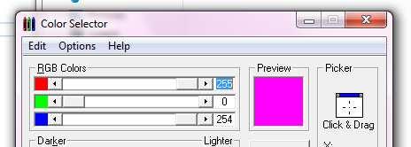

13


14 Principle of RGB NIR1.6 VIS0.8 VIS0.6

15 Principle of RGB
16 Earth Surface Sun Glint Sand Desert Channel 03 (NIR1.6) Clouds High reflectance Water clouds with small droplets Gras, Rice fields Forest Bare Soil Water clouds with large droplets Ice clouds with small particles Snow Ocean, Sea 31 October 2003, 11:30 UTC Ice clouds with large particles Low reflectance
17 Earth Surface Sun Glint Snow Channel 02 (VIS0.8) Clouds High reflectance Very thick clouds Desert Gras, Rice fields Forest Bare Soil Very thin clouds over land Ocean, Sea 31 October 2003, 11:30 UTC Very thin clouds over ocean Low reflectance
18 Earth Surface Sun Glint Snow Channel 01 (VIS0.6) Clouds High reflectance Very thick clouds Desert Bare Soil Very thin clouds over land Forest Ocean, Sea 31 October 2003, 11:30 UTC Very thin clouds over ocean Low reflectance


19 Principle of RGB
20 Earth Surface Sun Glint Sand Desert Channel 03 (NIR1.6) Clouds High reflectance Water clouds with small droplets Gras, Rice fields Forest Bare Soil Water clouds with large droplets Ice clouds with small particles Snow Ocean, Sea 31 October 2003, 11:30 UTC Ice clouds with large particles Low reflectance
21 Earth Surface Sun Glint Snow Channel 02 (VIS0.8) Clouds High reflectance Very thick clouds Desert Gras, Rice fields Forest Bare Soil Very thin clouds over land Ocean, Sea 31 October 2003, 11:30 UTC Very thin clouds over ocean Low reflectance
22 Earth Surface Sun Glint Snow Channel 01 (VIS0.6) Clouds High reflectance Very thick clouds Desert Bare Soil Very thin clouds over land Forest Ocean, Sea 31 October 2003, 11:30 UTC Very thin clouds over ocean Low reflectance

23 Principle of RGB
 Clouds High reflectance Water clouds with small droplets Gras, Rice fields Forest Bare Soil Water clouds with large droplets Ice clouds with small")
24 Earth Surface Sun Glint Sand Desert Channel 03 (NIR1.6) Clouds High reflectance Water clouds with small droplets Gras, Rice fields Forest Bare Soil Water clouds with large droplets Ice clouds with small particles Snow Ocean, Sea 31 October 2003, 11:30 UTC Ice clouds with large particles Low reflectance
25 Earth Surface Sun Glint Snow Channel 02 (VIS0.8) Clouds High reflectance Very thick clouds Desert Gras, Rice fields Forest Bare Soil Very thin clouds over land Ocean, Sea 31 October 2003, 11:30 UTC Very thin clouds over ocean Low reflectance
 Clouds High reflectance Very thick clouds Desert")

26 Earth Surface Sun Glint Snow Channel 01 (VIS0.6) Clouds High reflectance Very thick clouds Desert Bare Soil Very thin clouds over land Forest Ocean, Sea 31 October 2003, 11:30 UTC Very thin clouds over ocean Low reflectance
27 RGB RGB gives bluish surface colours gives more "natural colours" MSG-1, 16 March 2004, 16:00 UTC
28 RGB Image Composites Pros & Cons Advantages: Millions of colours: high information content; Easily implemented; Preserves natural look of images by retaining original textures (in particular for clouds); Preserves temporal continuity allowing for smooth animation of RGB image sequences. Drawbacks: Millions of colours compared to discrete classes used in quantitative image products interpretation more difficult; Cannot be handled by colour-blind.
29 Rules for Creating Good RGB Products Selection of the three inputs Select three channels or channel differences that represent three different but relevant physical properties!!! Proper enhancement of the three inputs: Convert from radiances to brightness temperatures (IR) or reflectances (VIS); Reduce the range [BTmin, BTmax] for optimal contrast; Gamma correction, if needed


30 Stretching of Intensity Range: Example Range = -15 K / +15 K, Γ=1.0 Range = -15 K / 0 K, Γ=1.0 MSG-1, 3 March 2004, 12:00 UTC, Diff. IR8.7 - IR10.8


31 Gamma Correction: Example Range = 0-100%, Γ=0.5 Range = 0-100%, Γ=1.0 Range = 0-100%, Γ=2.0 MSG-1, 3 March 2004, 12:00 UTC, Channel 01 (VIS0.6)
32 RECOMMENDED SCHEMES FOR RGB IMAGE COMPOSITES WITH MSG SEVIRI
33 RGBs for Operational Forecasting At WMO level: agree on a strict minimum of harmonised RGB composites 24-7 capability IR channels only Two RGB composites which complement each other: 24-h Microphysics Airmass Five application specific RGBs
34 MSG RGB Tutorial (MSG Interpretation Guide) RGB Composite Applications Time a. 3b RGB 10-09,09-07,09 Dust, Clouds (thickness, phase), Contrails Day & Night (24-h Ash microphysics): Fog, Ash, SO2, Low-level Humidity RGB 05-06,08-09,05 Severe Cyclones, Jets, PV Analysis Day & Night RGB 10-09,09-04,09 (Night microphysics): Clouds, Fog, Contrails, Fires Night RGB 02,04r,09 (Day Microphysics): Clouds, Convection, Snow, Fog, Fires Day RGB 05-06,04-09,03-01: Severe Convection Day RGB 02,03,04r: Snow, Fog Day RGB 03,02,01: Vegetation, Snow, Smoke, Dust, Fog Day
35 EUMETSAT training in RGBs EUMETSAT involved in several training events MSG interpretation guide on EUMETSAT website Case studies for different features in different countries on EUMETSAT website For each RGB: The recommended ranges The recommended gamma corrections The colour interpretations (charts) Several examples for the different features
36 Examples of some of these RGBs 1. Day Natural RGB (3-2-1) 2. Day Microphysics (2,4r,9) hour night microphysics (10-9,9-4,9)
37 1. RGB 03, 02, 01 ("Day Natural Colours") R = Channel 03 (NIR1.6) G = Channel 02 (VIS0.8) B = Channel 01 (VIS0.6) Applications: Area: Time: Vegetation, Dust, Smoke, Fog, Snow Full MSG Viewing Area Day-Time
38 RGB 03, 02, 01: Interpretation of Colours High-level ice clouds Low-level water clouds Ocean Veg. Land Desert Snow
39 RGB 03, 02, 01 Example: Low-level Water Clouds (St, Sc) NIR1.6 VIS0.8 VIS0.6 In RGB 03,02,01 images, low water clouds with small droplets appear in whitish-blue/pinkish colours! The values shown above (in the red box) correspond to the location (shown by an arrow) on the next slide!
40 RGB 03, 02, 01 Example: Low-level Water Clouds (St, Sc) MSG-1, 03 February 2004, 11:30 UTC
41 RGB 03, 02, 01: Not the best for convection but still useful! Thin Ice Cloud (small ice) Maputo Thin Ice Cloud (large ice) Thick Ice Cloud (large ice) Thick Ice Cloud (small ice) MSG-1, 6 November 2004, 12:00 UTC, RGB 03, 02, 01
42 Convection Uganda Lowlevel Cloud s Somalia Thin Cirrus Convection Day & Night Convection Kenya/Uganda Kenya Meteosat-8, 24 April :00 UTC Tanzania RGB Composite R = NIR1.6 G = VIS0.8 B = VIS0.6 Pretoria, July
43 Severe Convection Chad Sudan Convection Day & Night Convection N. Cameroon Central African Republic Squall Line Meteosat-8, 20 May :00 UTC Dem. Republic of the Kongo RGB Composite R = NIR1.6 G = VIS0.8 B = VIS0.6 Pretoria, July
44 2. RGB 02, 04r, 09 ("Day Microphysics") devised by: D. Rosenfeld R = Channel 02 (VIS0.8) G = Channel 04r (IR3.9, solar component) B = Channel 09 (IR10.8) Applications: Area: Time: Users: Cloud Analysis, Convection, Fog, Snow, Fires Full MSG Viewing Area Day-Time Hungary, Israel, South Africa
45 RGB 02, 04r, 09 ("Day Microphysics") devised by: D. Rosenfeld Recommended Range and Enhancement: Beam Channel Range Gamma Red 02 (VIS0.8) % 1.0 Green 04r (IR3.9r) % 2.5 Blue 09 (IR10.8) K 1.0
46 Physical Interpretation (for dust/ash/water/ice clouds) R = Difference VIS0.8 Optical Thickness, Viewing Geometry G = Difference IR3.9r Optical Thickness, Phase, Particle Size, Viewing Geometry B = Channel IR10.8 Top Temperature
47 Interpretation of Colours for High-level Clouds Deep precipitating cloud (precip. not necessarily reaching the ground) Deep precipitating cloud (Cb cloud with strong updrafts and severe weather)* Thin Cirrus cloud (large ice particles) Thin Cirrus cloud (small ice particles) - bright, thick - large ice particles - cold cloud - bright, thick - small ice particles - cold cloud *or thick, high-level lee cloudiness with small ice particles Ocean Veg. Land Fires / Desert Snow
48 Interpretation of Colours for Mid-level Clouds Supercooled, thick water cloud Supercooled, thick water cloud Supercooled thin water cloud with large droplets Supercooled, thin water cloud with small droplets * - bright, thick - large droplets - bright, thick - small droplets * or, in rare occasions, thin Ci cloud with small ice particles Ocean Veg. Land Fires / Desert Snow
49 Interpretation of Colours for Low-level Clouds Thick water cloud (warm rain cloud) - bright, thick - large droplets Thick water cloud (no precipitation) - bright, thick - small droplets Thin water cloud with large droplets Thin water cloud with small droplets Ocean Veg. Land Fires / Desert Snow
50 Example 1: Severe Convection MSG-1, 13 June 2003, 12:00 UTC
51 Example 3: Fires MSG-1, 27 April 2004, 14:15 UTC


52 Example 4: Ice vs Water Clouds ice ice MSG-1, 8 October 2003, 12:00 UTC mixed water water ice
53 Small vs Large Ice Particles Thin Ice Cloud (small ice) Maputo Thin Ice Cloud (large ice) Thick Ice Cloud (large ice) Thick Ice Cloud (small ice) MSG-1, 6 November 2004, 12:00 UTC
54 WHAT ABOUT NIGHT TIME?
55 3. RGB 10-09, 09-04, 09 ("Night Microphysics") devised by: D. Rosenfeld R = Difference IR IR10.8 G = Difference IR IR3.9 B = Channel IR10.8 Applications: Area: Time: Users: Cloud Analysis, Fog, Contrails, (Snow) Full MSG Viewing Area Night-Time most European & African NMSs, Middle East


56 Ch.10 -Ch.09 Ch.09 -Ch.04 Ch.09 MSG-1, 9 November 2003, 02:45 UTC RGB Composite 10-09, 09-04, 09
57 RGB 10-09, 09-04, 09 ("Night Microphysics") devised by: D. Rosenfeld Recommended Range and Enhancement: Beam Channel Range Gamma Red IR IR K 1.0 Green IR IR K 1.0 Blue IR K 1.0
58 Physical Interpretation (for dust/ash/water/ice clouds) R = Difference IR IR10.8 Optical Thickness, Tsurf-Tcloud G = Difference IR10.8 IR3.9 Optical Thickness, Tsurf-Tcloud, Phase, Particle Size B = Channel IR10.8 Top Temperature
59
60

61 Example: Fog MSG-1, 14 March 2005, 00:00 UTC
62 Example: Cb MSG-1, 19 April 2005, 03:15 UTC

63 Example: Cirrus MSG-1, 18 March 2005, 00:00 UTC
64 Example: Fire MSG-1, 16 May 2006, 00:00 UTC
65 Summary Red-Green-Blue combinations are useful to accentuate different features in satellite imagery for different applications such as convection, fires, fog etc Using the Colour Selector tool it is easy to see the role played by each channel (or channel difference) Altering the range and gamma settings is useful for specific purposes Using the WMO standard for RGB products is essential
66 Quiz
67 DAY NATURAL (3-2-1)
68 Where are water clouds and where thicker Cu/Cb? SOUTH AFRICA 2 December 2005, 12 UTC
69 RGB 03, 02, 01: Interpretation of Colours High-level ice clouds Low-level water clouds Ocean Veg. Land Desert Snow
70 Where are water clouds and where thicker Cu/Cb? SOUTH AFRICA 2 December 2005, 12 UTC
71 2 December 2005, 12 UTC Natural Colours RGB thicker Cu/Cb clouds SOUTH AFRICA Water clouds
72 DAY MICROPHYSICAL (2,4R,9)
73 Where are ice clouds and where water clouds? MSG-1, 26 August 2005, 12:00 UTC
74 Interpretation of Colours for High-level Clouds Deep precipitating cloud (precip. not necessarily reaching the ground) Deep precipitating cloud (Cb cloud with strong updrafts and severe weather)* Thin Cirrus cloud (large ice particles) Thin Cirrus cloud (small ice particles) - bright, thick - large ice particles - cold cloud - bright, thick - small ice particles - cold cloud *or thick, high-level lee cloudiness with small ice particles Ocean Veg. Land Fires / Desert Snow
75 Interpretation of Colours for Mid-level Clouds Supercooled, thick water cloud Supercooled, thick water cloud Supercooled thin water cloud with large droplets Supercooled, thin water cloud with small droplets * - bright, thick - large droplets - bright, thick - small droplets * or, in rare occasions, thin Ci cloud with small ice particles Ocean Veg. Land Fires / Desert Snow
76 Interpretation of Colours for Low-level Clouds Thick water cloud (warm rain cloud) - bright, thick - large droplets Thick water cloud (no precipitation) - bright, thick - small droplets Thin water cloud with large droplets Thin water cloud with small droplets Ocean Veg. Land Fires / Desert Snow
77 Where are ice clouds and where water clouds? MSG-1, 26 August 2005, 12:00 UTC
78 Ice vs Water Clouds water water ice MSG-1, 26 August 2005, 12:00 UTC ice ice
79 NIGHT MICROPHYSICAL (10-9,9-4,9)
80 Where are the convective clouds (Cb)? Guinea Cote d'ivoire MSG-1, 19 April 2005, 03:15 UTC > IMAGE GALLERY, Derived Products, Fog
81
82
83 Where are the convective clouds (Cb)? Guinea Cote d'ivoire MSG-1, 19 April 2005, 03:15 UTC > IMAGE GALLERY, Derived Products, Fog
84 Where are the convective clouds (Cb)? Guinea Cb clouds Cote d'ivoire MSG-1, 19 April 2005, 03:15 UTC
85 Thank you! Contributors: HP. Roesli (EUM), D. Rosenfeld (Israel), M. Setvak (CZ), M. König (EUM), G. Bridge (EUM EUM), E. De Coning (RSA), A. Eronn (Sweden), K. Kollath & M. Putsay (Hungary), H. Kocak (Turkey), J. Schipper (Austria), V. Nietosvaara (Finland), S. Gallino (Italy), P. Santurette (France), C. Georgiev (Bulgaria)
RGB Products: an easy and practical way to display multispectral satellite data (in combination with derived products)
") RGB Products: an easy and practical way to display multispectral satellite data (in combination with derived products) Dr. Jochen Kerkmann Training Officer EUMETSAT Multi-channel GEO satellites today Him-08
RGB Products: an easy and practical way to display multispectral satellite data (in combination with derived products) Dr. Jochen Kerkmann Training Officer EUMETSAT Multi-channel GEO satellites today Him-08
How to display RGB imagery by SATAID
 How to display RGB imagery by SATAID Akihiro SHIMIZU Meteorological Satellite Center (MSC), Japan Meteorological Agency (JMA) Ver. 2015110500 RGB imagery on SATAID SATAID software has a function of overlapping
Day Microphysics RGB Nephanalysis in daytime. Meteorological Satellite Center, JMA
 Day Microphysics RGB Nephanalysis in daytime Meteorological Satellite Center, JMA What s Day Microphysics RGB? R : B04 (N1 0.86) Range : 0~100 [%] Gamma : 1.0 G : B07(I4 3.9) (Solar component) Range :
Detection and Monitoring Convective Storms by. Using MSG SEVIRI Image. Aydın Gürol ERTÜRK. Contents
 Detection and Monitoring Convective Storms by 1 Using MSG SEVIRI Image Contents MSGView Software Cold U/V and Ring Shape Storm Tops Case Study, 2nd April 2011 Antalya, Türkiye Conclusion Aydın Gürol ERTÜRK
INTERPRETATION OF MSG IMAGES, PRODUCTS AND SAFNWC OUTPUTS FOR DUTY FORECASTERS
 INTERPRETATION OF MSG IMAGES, PRODUCTS AND SAFNWC OUTPUTS FOR DUTY FORECASTERS M. Putsay, M. Rajnai, M. Diószeghy, J. Kerényi, I.G. Szenyán and S. Kertész Hungarian Meteorological Service, H-1525 Budapest,
MSGVIEW: AN OPERATIONAL AND TRAINING TOOL TO PROCESS, ANALYZE AND VISUALIZATION OF MSG SEVIRI DATA
 MSGVIEW: AN OPERATIONAL AND TRAINING TOOL TO PROCESS, ANALYZE AND VISUALIZATION OF MSG SEVIRI DATA Aydın Gürol Ertürk Turkish State Meteorological Service, Remote Sensing Division, CC 401, Kalaba Ankara,
Day Snow-Fog RGB Detection of low-level clouds and snow/ice covered area
 JMA Day Snow-Fog RGB Detection of low-level clouds and snow/ice covered area Meteorological Satellite Center, JMA What s Day Snow-Fog RGB? R : B04 (N1 0.86) Range : 0~100 [%] Gamma : 1.7 G : B05 (N2 1.6)
HARMONISING SEVIRI RGB COMPOSITES FOR OPERATIONAL FORECASTING
 HARMONISING SEVIRI RGB COMPOSITES FOR OPERATIONAL FORECASTING HansPeter Roesli (1), Jochen Kerkmann (1), Daniel Rosenfeld (2) (1) EUMETSAT, Darmstadt DE, (2) The Hebrew University of Jerusalem, Jerusalem
Introduction of JMA VLab Support Site on RGB Composite Imagery and tentative RGBs
 The Sixth Asia/Oceania Meteorological Satellite Users' Conference 9 13 November 2015, Tokyo/Japan J M A Introduction of JMA VLab Support Site on RGB Composite Imagery and tentative RGBs Akihiro SHIMIZU
Satellite Meteorology. Protecting Life and Property Around the World
 Satellite Meteorology Protecting Life and Property Around the World The Value of Forecasting Severe Weather Flooding events across Europe in August 2002 cost in the region of 20 billion; 20,000 people
MSG/SEVIRI CHANNEL 4 Short-Wave IR 3.9 m IR3.9 Tutorial
 MSG/SEVIRI CHANNEL 4 Short-Wave IR Channel @ 3.9 m IR3.9 Tutorial HansPeter Roesli EUMETSAT satmet.hp@ticino.com Contributions: D Rosenfeld (HUJ) J Kerkmann (EUM), M Koenig (EUM), J Prieto (EUM), HJ Lutz
Applications of the SEVIRI window channels in the infrared.
 Applications of the SEVIRI window channels in the infrared jose.prieto@eumetsat.int SEVIRI CHANNELS Properties Channel Cloud Gases Application HRV 0.7 Absorption Scattering
New capabilities with high resolution cloud micro-structure facilitated by MTG 2.3 um channel
 Slide 19 November 2016, V1.0 New capabilities with high resolution cloud micro-structure facilitated by MTG 2.3 um channel Author: Daniel Rosenfeld The Hebrew University of Jerusalem (HUJ) daniel.rosenfeld@huji.ac.il
Khalid Y. Muwembe UGANDA NATIONAL METEOROLOGICAL AUTHORITY (UNMA)
") Forecasting Severe Weather over Lake Victoria region in Uganda Khalid Y. Muwembe UGANDA NATIONAL METEOROLOGICAL AUTHORITY (UNMA) Outline Background Set-up of forecasting/alert service Diurnal circulation
Forecasting Severe Weather over Lake Victoria region in Uganda Khalid Y. Muwembe UGANDA NATIONAL METEOROLOGICAL AUTHORITY (UNMA) Outline Background Set-up of forecasting/alert service Diurnal circulation
Monitoring Sand and Dust Storms from Space
 Monitoring Sand and Dust Storms from Space for Expert Consultation on Disaster Information and Knowledge, Session 2 ICC 21 for ESCAP s RESAP and CDRR 5 9 12 October, 2017 Toshiyuki KURINO WMO Space Programme
MSG FOR NOWCASTING - EXPERIENCES OVER SOUTHERN AFRICA
 MSG FOR NOWCASTING - EXPERIENCES OVER SOUTHERN AFRICA Estelle de Coning and Marianne König South African Weather Service, Private Bag X097, Pretoria 0001, South Africa EUMETSAT, Am Kavalleriesand 31, D-64295
Himawari-8 True Color RGB
 Himawari-8 True Color RGB Meteorological Satellite Center, JMA Ver. 20150519 What s True Color RGB? R : B03(VS 0.64) G : B02(V2 0.51) 2015-03-17 00UTC B : B01(V1 0.46) Components of True Color RGB Channel
Combined and parallel use of MSG composite images and SAFNWC/MSG products at the Hungarian Meteorological Service
 Combined and parallel use of MSG composite images and SAFNWC/MSG products at the Hungarian Meteorological Service Mária Putsay, Kornél Kolláth and Ildikó Szenyán Hungarian Meteorological Service H-1525
Ash RGB Detection of Volcanic Ash
 Copyright, JMA RGB Detection of Volcanic Meteorological Satellite Center, JMA Ver. 20150424 Volcanic Detection by Infrared and Difference Image, and Basis Himawari-8 B15-B13 2015-02-16 06:35 UTC Himawari-8
CASE STUDY OF THE 20 MAY 2008 TORNADIC STORM IN HUNGARY
 CASE STUDY OF THE 20 MAY 2008 TORNADIC STORM IN HUNGARY Mária Putsay 1, Jochen Kerkmann 2 and Ildikó Szenyán 1 1 Hungarian Meteorological Service, H-1525 Budapest, P. O. Box 38, Hungary 2 EUMETSAT, am
Nowcasting of Severe Weather from Satellite Images (for Southern
 Nowcasting of Severe Weather from Satellite Images (for Southern Europe) Petra Mikuš Jurković Forecasting/ nowcasting of convective storms NWP models cannot well predict the exact location and intesity
RGB Experts and Developers Workshop - Introduction Tokyo, Japan 7-9 Nov 2017
 RGB Experts and Developers Workshop - Introduction Tokyo, Japan 7-9 Nov 2017 Workshop Objectives Review of existing RGB standards Reconfirm and extend existing standards (new multi-spectral imagers) Stimulate
Comparison of cloud statistics from Meteosat with regional climate model data
 Comparison of cloud statistics from Meteosat with regional climate model data R. Huckle, F. Olesen, G. Schädler Institut für Meteorologie und Klimaforschung, Forschungszentrum Karlsruhe, Germany (roger.huckle@imk.fzk.de
SAFNWC/MSG Dust flag.
 SAFNWC/MSG Dust flag. Dust Week 1-5 March 2010 Hervé LE GLEAU, Marcel DERRIEN Centre de météorologie Spatiale. Lannion Météo-France 1 Plan SAFNWC context Dust flag in SAFNWC/MSG Cma product Algorithm description
MSG system over view
 MSG system over view 1 Introduction METEOSAT SECOND GENERATION Overview 2 MSG Missions and Services 3 The SEVIRI Instrument 4 The MSG Ground Segment 5 SAF Network 6 Conclusions METEOSAT SECOND GENERATION
" The usefulness of RGB products: the perspective of the Australian Bureau of Meteorology "
 " The usefulness of RGB products: the perspective of the Australian Bureau of Meteorology " Presenter: Bodo Zeschke. Bureau of Meteorology Training Centre, Australian VLab Centre of Excellence Point of
MSG Indian Ocean Data Coverage (IODC) Jochen Grandell & Sauli Joro
 Jochen Grandell & Sauli Joro") MSG Indian Ocean Data Coverage (IODC) Jochen Grandell & Sauli Joro 1 EUM/STG-SWG/42/17/VWG/03 v1, 7 8 Mach 2017 Topics Introduction MSG-IODC Overall Project Schedule Status Product validation Products
MSG Indian Ocean Data Coverage (IODC) Jochen Grandell & Sauli Joro 1 EUM/STG-SWG/42/17/VWG/03 v1, 7 8 Mach 2017 Topics Introduction MSG-IODC Overall Project Schedule Status Product validation Products
EUMETSAT Satellite Programmes Use of McIDAS at EUMETSAT
 EUMETSAT Satellite Programmes Use of McIDAS at EUMETSAT Marianne König Peter Miu McIDAS Users' Group Meeting, 07-10 May 2012 Slide 1 EUMETSAT Headquarters Darmstadt McIDAS Users' Group Meeting, 07-10 May
YELLOW SPOT IN THE CONVECTIVE STORMS RGB IMAGE CAUSED BY A PILEUS CLOUD
 YELLOW SPOT IN THE CONVECTIVE STORMS RGB IMAGE CAUSED BY A PILEUS CLOUD André Simon, Mária Putsay, Ildikó Szenyán and Ákos Horváth Hungarian Meteorological Service, Kitaibel Pál u. 1, H-1024 Budapest,
INTERPRETATION GUIDE TO MSG WATER VAPOUR CHANNELS
 INTERPRETATION GUIDE TO MSG WATER VAPOUR CHANNELS C.G. Georgiev1 and P. Santurette2 1 National Institute of Meteorology and Hydrology, Tsarigradsko chaussee 66, 1784 Sofia, Bulgaria 2 Météo-France, 42,
Satellite data for African applications
 Satellite data for African applications Henk Verschuur, EUMETSAT henk.verschuur@eumetsat.int Introduction Some examples of satellite products which are useful for Africa Satellite products Tropical cyclones
RGB Experts and Developers Workshop 2017 Tokyo, Japan
 "Application of the Sandwich Product and variations to this as used by Australian Forecasters and as presented during training at the Australian VLab Centre of Excellence". RGB Experts and Developers Workshop
USE OF SATELLITE INFORMATION IN THE HUNGARIAN NOWCASTING SYSTEM
 USE OF SATELLITE INFORMATION IN THE HUNGARIAN NOWCASTING SYSTEM Mária Putsay, Zsófia Kocsis and Ildikó Szenyán Hungarian Meteorological Service, Kitaibel Pál u. 1, H-1024, Budapest, Hungary Abstract The
QUALITY OF MPEF DIVERGENCE PRODUCT AS A TOOL FOR VERY SHORT RANGE FORECASTING OF CONVECTION
 QUALITY OF MPEF DIVERGENCE PRODUCT AS A TOOL FOR VERY SHORT RANGE FORECASTING OF CONVECTION C.G. Georgiev 1, P. Santurette 2 1 National Institute of Meteorology and Hydrology, Bulgarian Academy of Sciences
REPORT ON THE ACTIVITIES OF THE EUMETSAT-ESSL CONVECTION WORKING GROUP
 REPORT ON THE ACTIVITIES OF THE EUMETSAT-ESSL CONVECTION WORKING GROUP Marianne König EUMETSAT, Eumetsat Allee 1, 64295 Darmstadt, Germany Abstract The focus of the Convection Working Group is to have
Himawari-8 RGB product use and development amongst Australian / RAV / RAII stakeholders: the Australian VLab Centre of Excellence perspective
 Himawari-8 RGB product use and development amongst Australian / RAV / RAII stakeholders: the Australian VLab Centre of Excellence perspective EUMeTrain Event Week on MTG-I satellite 7-11 November 2016
SATELLITE MONITORING OF THE CONVECTIVE STORMS
 SATELLITE MONITORING OF THE CONVECTIVE STORMS FORECASTERS POINT OF VIEW Michaela Valachová, EUMETSAT Workshop at ECMWF User Meeting Reading, 13 June 2017 Central Forecasting Office, Prague michaela.valachova@chmi.cz
Basic cloud Interpretation using Satellite Imagery
 Basic cloud Interpretation using Satellite Imagery Introduction Recall that images from weather satellites are actually measurements of energy from specified bands within the Electromagnetic (EM) spectrum.
Improving real time observation and nowcasting RDT. E de Coning, M Gijben, B Maseko and L van Hemert Nowcasting and Very Short Range Forecasting
 Improving real time observation and nowcasting RDT E de Coning, M Gijben, B Maseko and L van Hemert Nowcasting and Very Short Range Forecasting Introduction Satellite Application Facilities (SAFs) are
PRECONVECTIVE SOUNDING ANALYSIS USING IASI AND MSG- SEVIRI
 PRECONVECTIVE SOUNDING ANALYSIS USING IASI AND MSG- SEVIRI Marianne König, Dieter Klaes EUMETSAT, Eumetsat-Allee 1, 64295 Darmstadt, Germany Abstract EUMETSAT operationally generates the Global Instability
EUMETSAT products and services for monitoring storms - New missions, more data and more meteorological products
 EUMETSAT products and services for monitoring storms - New missions, more data and more meteorological products Jochen Grandell 1 EUM/RSP/VWG/17/921460 Outline Overview of EUMETSAT missions Current...and
The water vapour channels of SEVIRI (Meteosat). An introduction
. An introduction") The water vapour channels of SEVIRI (Meteosat). An introduction jose.prieto@eumetsat.int Cachoeira P. July 2006 Formats 1.5 1 Objectives 2 Describe the characteristics of WV channels on board of SEVIRI
The water vapour channels of SEVIRI (Meteosat). An introduction jose.prieto@eumetsat.int Cachoeira P. July 2006 Formats 1.5 1 Objectives 2 Describe the characteristics of WV channels on board of SEVIRI
T-re Plots Generated from MSG Data in Severe Storms Forecasting Testing in Central Europe
 WDS'11 Proceedings of Contributed Papers, Part III, 88 92, 2011. ISBN 978-80-7378-186-6 MATFYZPRESS T-re Plots Generated from MSG Data in Severe Storms Forecasting Testing in Central Europe M. Pokorný
VALIDATION RESULTS OF THE OPERATIONAL LSA-SAF SNOW COVER MAPPING
 VALIDATION RESULTS OF THE OPERATIONAL LSA-SAF SNOW COVER MAPPING Niilo Siljamo, Otto Hyvärinen Finnish Meteorological Institute, Erik Palménin aukio 1, P.O.Box 503, FI-00101 HELSINKI Abstract Hydrological
The importance of satellite data for nowcasting in the WWRP strategy
 The importance of satellite data for nowcasting in the WWRP strategy Estelle de Coning and Paolo Ruti World Weather Research Division Steve Goodman Chief Program Scientist, NOAA WMO definition Nowcasting
METEOSAT CONVECTIVE INITIATION PRODUCT WITH AND WITHOUT CLOUD TRACKING - EXPERIENCES
 METEOSAT CONVECTIVE INITIATION PRODUCT WITH AND WITHOUT CLOUD TRACKING - EXPERIENCES Mária Putsay 1, Zsófia Kocsis 1, Marianne König 2, Ildikó Szenyán 1, Márta Diószeghy 1, André Simon 1 and Márk Rajnai
Climate & Earth System Science. Introduction to Meteorology & Climate. Chapter 05 SOME OBSERVING INSTRUMENTS. Instrument Enclosure.
 Climate & Earth System Science Introduction to Meteorology & Climate MAPH 10050 Peter Lynch Peter Lynch Meteorology & Climate Centre School of Mathematical Sciences University College Dublin Meteorology
Aviation Hazards: Thunderstorms and Deep Convection
 Aviation Hazards: Thunderstorms and Deep Convection TREND Diagnosis of thunderstorm hazards using imagery Contents Satellite imagery Visible, infrared, water vapour Basic cloud identification Identifying
EUMETSAT Satellite Status
 EUMETSAT Satellite Status Dr. K. Dieter Klaes EUMETSAT 1 ET-SAT Meeting 4-6 April 2017, WMO, Geneva, Switzerland EUMETSAT is an intergovernmental organisation with 30 Member States and 1 Cooperating State
Use of satellite information in research and operational activities at NIMH of Bulgaria
 Use of satellite information in research and operational activities at NIMH of Bulgaria Rilka Valcheva NIMH, Bulgaria WMO/EUMETSAT Satellite Products Training Course 24-28 April 2017, Budapest, Hungary
Satellite observation of atmospheric dust
 Satellite observation of atmospheric dust Taichu Y. Tanaka Meteorological Research Institute, Japan Meteorological Agency 11 April 2017, SDS WAS: Dust observation and modeling @WMO, Geneva Dust observations
A SEVERE WEATHER EVENT IN ROMANIA DUE TO MEDITERRANEAN CYCLONIC ACTIVITY
 A SEVERE WEATHER EVENT IN ROMANIA DUE TO MEDITERRANEAN CYCLONIC ACTIVITY Florinela Georgescu, Gabriela Bancila, Viorica Dima National Meteorological Administration, Bucharest, Romania Abstract Mediterranean
Atmospheric Motion Vectors: Product Guide
 Atmospheric Motion Vectors: Product Guide Doc.No. Issue : : EUM/TSS/MAN/14/786435 v1a EUMETSAT Eumetsat-Allee 1, D-64295 Darmstadt, Germany Tel: +49 6151 807-7 Fax: +49 6151 807 555 Date : 9 April 2015
SAFNWC/MSG SEVIRI CLOUD PRODUCTS
 SAFNWC/MSG SEVIRI CLOUD PRODUCTS M. Derrien and H. Le Gléau Météo-France / DP / Centre de Météorologie Spatiale BP 147 22302 Lannion. France ABSTRACT Within the SAF in support to Nowcasting and Very Short
Preparation for Himawari 8
 Preparation for Himawari 8 Japan Meteorological Agency Meteorological Satellite Center Hidehiko MURATA ET SUP 8, WMO HQ, Geneva, 14 17 April 2014 1/18 Introduction Background The Japan Meteorological Agency
Overview of Himawari-8/9
 Overview of Himawari-8/9 Toshiyuki SAKURAI Meteorological Satellite Center (MSC) Japan Meteorological Agency (JMA) EUMeTrain Event Week on MTG-I Satellite 2016 Session2 - Himawari-8 and Data Applications
Introduction to African weather
 Introduction to African weather Dr Caroline Bain Met Office, Exeter, UK Overview Convection and general circulation A tour around the seasons: West African Monsoon, AEWs, Short rains East Africa, Low-level
PRECIPITATION ESTIMATION FROM INFRARED SATELLITE IMAGERY
 PRECIPITATION ESTIMATION FROM INFRARED SATELLITE IMAGERY A.M. BRASJEN AUGUST 2014 1 2 PRECIPITATION ESTIMATION FROM INFRARED SATELLITE IMAGERY MASTER S THESIS AUGUST 2014 A.M. BRASJEN Department of Geoscience
Meteosat Third Generation (MTG): Lightning Imager and its products Jochen Grandell
: Lightning Imager and its products Jochen Grandell") 1 Go to View menu and click on Slide Master to update this footer. Include DM reference, version number and date Meteosat Third Generation (MTG): Lightning Imager and its products Jochen Grandell Topics
1 Go to View menu and click on Slide Master to update this footer. Include DM reference, version number and date Meteosat Third Generation (MTG): Lightning Imager and its products Jochen Grandell Topics
Recent Changes in the Derivation of Geostationary AMVs at EUMETSAT. Manuel Carranza Régis Borde Marie Doutriaux-Boucher
 Recent Changes in the Derivation of Geostationary AMVs at EUMETSAT Manuel Carranza Régis Borde Marie Doutriaux-Boucher Summary Introduction to EUMETSAT s geostationary AMVs Recent changes: Cross-Correlation
Retrieval of precipitation from Meteosat-SEVIRI geostationary satellite observations
 Retrieval of precipitation from Meteosat-SEVIRI geostationary satellite observations Jan Fokke Meirink, Hidde Leijnse (KNMI) Rob Roebeling (EUMETSAT) Overview Introduction Algorithm description Validation
EUMETSAT Training activities. Vesa Nietosvaara Mark Higgins
 EUMETSAT Training activities Vesa Nietosvaara Mark Higgins EUMETSAT Partnerships Europe: SAFs and regional networks EUMeTrain training recourses and tools Eumetcal coordination and infrastructure Africa:
A statistical approach for rainfall confidence estimation using MSG-SEVIRI observations
 A statistical approach for rainfall confidence estimation using MSG-SEVIRI observations Elisabetta Ricciardelli*, Filomena Romano*, Nico Cimini*, Frank Silvio Marzano, Vincenzo Cuomo* *Institute of Methodologies
Rain rate retrieval using the 183-WSL algorithm
 Rain rate retrieval using the 183-WSL algorithm S. Laviola, and V. Levizzani Institute of Atmospheric Sciences and Climate, National Research Council Bologna, Italy (s.laviola@isac.cnr.it) ABSTRACT High
NUMERICAL EXPERIMENTS USING CLOUD MOTION WINDS AT ECMWF GRAEME KELLY. ECMWF, Shinfield Park, Reading ABSTRACT
 NUMERICAL EXPERIMENTS USING CLOUD MOTION WINDS AT ECMWF GRAEME KELLY ECMWF, Shinfield Park, Reading ABSTRACT Recent monitoring of cloud motion winds (SATOBs) at ECMWF has shown an improvement in quality.
Follow-up to WMO 2012 Survey on the Use of Satellite Data: Feedback by RA I Members
 WMO Follow-up to WMO 2012 Survey on the Use of Satellite Data: Feedback by RA I Members Gillie Cheelo-Intern WMO Space Programme World Meteorological Organization (WMO) WMO; Observation and Information
LANDSAF SNOW COVER MAPPING USING MSG/SEVIRI DATA
 LANDSAF SNOW COVER MAPPING USING MSG/SEVIRI DATA Niilo Siljamo and Otto Hyvärinen Finnish Meteorological Institute, Erik Palménin aukio 1, P.O.Box 503, FI-00101 Helsinki, Finland Abstract Land Surface
Climatologies of ultra-low clouds over the southern West African monsoon region
 Climatologies of ultra-low clouds over the southern West African monsoon region Andreas H. Fink 1, R. Schuster 1, R. van der Linden 1, J. M. Schrage 2, C. K. Akpanya 2, and C. Yorke 3 1 Institute of Geophysics
SNOW COVER MAPPING USING METOP/AVHRR DATA
 SNOW COVER MAPPING USING METOP/AVHRR DATA Niilo Siljamo, Markku Suomalainen, Otto Hyvärinen Finnish Meteorological Institute, Erik Palménin Aukio 1, FI-00101 Helsinki, Finland Abstract LSA SAF snow cover
Global Instability Index: Product Guide
 Doc.No. Issue : : EUM/TSS/MAN/15/802106 v1c e-signed EUMETSAT Eumetsat-Allee 1, D-64295 Darmstadt, Germany Tel: +49 6151 807-7 Fax: +49 6151 807 555 Date : 2 September 2015 http://www.eumetsat.int WBS/DBS
Report. Northern Africa. RAIDEG-8, 1-2 Nov 2017
 Report Northern Africa RAIDEG-8, 1-2 Nov 2017 Report Northern Africa RAIDEG-8, 1-2 Nov 2017 Important Note: Formal letters have been sent from the PR of Morocco with WMO to PRs of Algeria, Tunisia, Libya
NOAA/NESDIS Tropical Web Page with LEO Satellite Products and Applications for Forecasters
 NOAA/NESDIS Tropical Web Page with LEO Satellite Products and Applications for Forecasters Sheldon Kusselson National Oceanic and Atmospheric Administration (NOAA) National Environmental Satellite Data
Lecture 19: Operational Remote Sensing in Visible, IR, and Microwave Channels
 MET 4994 Remote Sensing: Radar and Satellite Meteorology MET 5994 Remote Sensing in Meteorology Lecture 19: Operational Remote Sensing in Visible, IR, and Microwave Channels Before you use data from any
Cloud Analysis Image: Product Guide
 Cloud Analysis Image: Product Guide Doc.No. : EUM/TSS/MAN/15/795729 EUMETSAT Eumetsat-Allee 1, D-64295 Darmstadt, Germany Tel: +49 6151 807-7 Issue : v1c Fax: +49 6151 807 555 Date : 19 February 2015 http://www.eumetsat.int
EUMETSAT PLANS. K. Dieter Klaes EUMETSAT Darmstadt, Germany
 EUMETSAT PLANS K. Dieter Klaes EUMETSAT Darmstadt, Germany 1. INTRODUCTION The European Organisation for the Exploitation of Meteorological Satellites (EUMETSAT), contributes to the World Weather Watch
eport Nataša Strelec Mahović Meteorological and Hydrological Service, Grič 3, Zagreb, Croatia EUMeTrain project Abstract
 eport Nataša Strelec Mahović Meteorological and Hydrological Service, Grič 3, Zagreb, Croatia EUMeTrain project Abstract The paper presents the concept of eport, an interface enabling the combined analysis
Meteorological Satellite Image Interpretations, Part III. Acknowledgement: Dr. S. Kidder at Colorado State Univ.
 Meteorological Satellite Image Interpretations, Part III Acknowledgement: Dr. S. Kidder at Colorado State Univ. Dates EAS417 Topics Jan 30 Introduction & Matlab tutorial Feb 1 Satellite orbits & navigation
International Cooperation in Operational Environmental Satellites: The U.S. Experience
 Committee on the Peaceful Uses of Outer Space Science and Technology Sub committee Forty seventh session February 17, 2010 Vienna, Austria International Cooperation in Operational Environmental Satellites:
IMPORTANCE OF SATELLITE DATA (FOR REANALYSIS AND BEYOND) Jörg Schulz EUMETSAT
 Jörg Schulz EUMETSAT") IMPORTANCE OF SATELLITE DATA (FOR REANALYSIS AND BEYOND) Jörg Schulz EUMETSAT Why satellite data for climate monitoring? Global coverage Global consistency, sometimes also temporal consistency High spatial
IMPORTANCE OF SATELLITE DATA (FOR REANALYSIS AND BEYOND) Jörg Schulz EUMETSAT Why satellite data for climate monitoring? Global coverage Global consistency, sometimes also temporal consistency High spatial
EUMETSAT PLANS. Dr. K. Dieter Klaes EUMETSAT Am Kavalleriesand 31 D Darmstadt Germany
 EUMETSAT PLANS Dr. K. Dieter Klaes EUMETSAT Am Kavalleriesand 31 D-64295 Darmstadt Germany Page 1 EUMETSAT SATELLITE PROGRAMMES 96 97 98 99 00 01 02 03 04 05 06 07 08 09 10 11 12 13 14 15 16 17 18 METEOSAT
Instrumentation planned for MetOp-SG
 Instrumentation planned for MetOp-SG Bill Bell Satellite Radiance Assimilation Group Met Office Crown copyright Met Office Outline Background - the MetOp-SG programme The MetOp-SG instruments Summary Acknowledgements:
VWG.01 EUMETSAT Corporate Slide Collection (EUM/CIS/VWG/14/743878) Version 1, January 2014 MONITORING WEATHER AND CLIMATE FROM SPACE
 Version 1, January 2014 MONITORING WEATHER AND CLIMATE FROM SPACE") 1 VWG.01 EUMETSAT Corporate Slide Collection (EUM/CIS/VWG/14/743878) Version 1, January 2014 MONITORING WEATHER AND CLIMATE FROM SPACE Royal charter: 25/26 October 1859 From observation to decision making:
1 VWG.01 EUMETSAT Corporate Slide Collection (EUM/CIS/VWG/14/743878) Version 1, January 2014 MONITORING WEATHER AND CLIMATE FROM SPACE Royal charter: 25/26 October 1859 From observation to decision making:
SATREP Online. Jarno Schipper Zentralanstalt für Meteorologie und Geodynamik, Austria. Vesa Nietosvaara Finnish Met Institute, Finland
 SATREP Online Jarno Schipper Zentralanstalt für Meteorologie und Geodynamik, Austria. Vesa Nietosvaara Finnish Met Institute, Finland SATellite REPort A method of deriving a thorough view of the actual
Three things necessary for weather are Heat, Air, Moisture (HAM) Weather takes place in the Troposphere (The lower part of the atmosphere).
 Weather takes place in the Troposphere (The lower part of the atmosphere).") Grade 5 SCIENCE WEATHER WATCH Name: STUDY NOTES Weather - The condition of the atmosphere with respect to heat/cold, wetness/dryness, clearness/ cloudiness for a period of time. Weather changes over time
Grade 5 SCIENCE WEATHER WATCH Name: STUDY NOTES Weather - The condition of the atmosphere with respect to heat/cold, wetness/dryness, clearness/ cloudiness for a period of time. Weather changes over time
Optical properties of thin cirrus derived from the infrared channels of SEVIRI
 Optical properties of thin cirrus derived from the infrared channels of SEVIRI Stephan Kox, A. Ostler, M. Vazquez-Navarro, L. Bugliaro, H. Mannstein Deutsches Zentrum für Luft- und Raumfahrt (DLR), Oberpfaffenhofen,
Observations needed for verification of additional forecast products
 Observations needed for verification of additional forecast products Clive Wilson ( & Marion Mittermaier) 12th Workshop on Meteorological Operational Systems, ECMWF, 2-6 November 2009 Additional forecast
EUMETSAT NEWS. Marianne König.
 EUMETSAT NEWS Marianne König marianne.koenig@eumetsat.int www.eumetsat.int MUG 2010 26 Member States & 5 Cooperating States * Member States AUSTRIA BELGIUM CROATIA CZECH REPUBLIC DENMARK FINLAND FRANCE
EUMETSAT SAF NETWORK. Lothar Schüller, EUMETSAT SAF Network Manager
 1 EUMETSAT SAF NETWORK Lothar Schüller, EUMETSAT SAF Network Manager EUMETSAT ground segment overview METEOSAT JASON-2 INITIAL JOINT POLAR SYSTEM METOP NOAA SATELLITES CONTROL AND DATA ACQUISITION FLIGHT
EUMETSAT s Support to Climate Services and User Support. Joachim Saalmüller
 EUMETSAT s Support to Climate Services and User Support Joachim Saalmüller 1 User Forum in Africa September 2016 Outline of my talk EUMETSAT in support of climate services Exploring our data and subscribing
New possibilities for access and utilisation of EUMETSAT data and products through DAWBEE programme
 See discussions, stats, and author profiles for this publication at: https://www.researchgate.net/publication/273637605 New possibilities for access and utilisation of EUMETSAT data and products through
Satellites, Weather and Climate Module 1: Introduction to the Electromagnetic Spectrum
 Satellites, Weather and Climate Module 1: Introduction to the Electromagnetic Spectrum What is remote sensing? = science & art of obtaining information through data analysis, such that the device is not
Simulated MSG SEVIRI Imagery from HARMONIE-AROME
 Simulated MSG SEVIRI Imagery from HARMONIE-AROME Angeles Hernandez, AEMET Joint 28th ALADIN Workshop & HIRLAM All-Staff Meeting 2018 - Toulouse, 16-20 Apr 2018 Outline 1. Simulated Satellite Images (SSI)
In-flight Calibration Techniques Using Natural Targets. CNES Activities on Calibration of Space Sensors
 In-flight Calibration Techniques Using Natural Targets CNES Activities on Calibration of Space Sensors Bertrand Fougnie, Patrice Henry (DCT/SI, CNES, Toulouse, France) In-flight Calibration using Natural
WATER IN THE ATMOSPHERE
 WATER IN THE ATMOSPHERE I. Humidity A. Defined as water vapor or moisture in the air (from evaporation and condensation). B. The atmosphere gains moisture from the evaporation of water from oceans, lakes,
NOWCASTING PRODUCTS BASED ON MTSAT-1R RAPID SCAN OBSERVATION. In response to CGMS Action 38.33
 CGMS-39, JMA-WP-08 Prepared by JMA Agenda Item: G.II/8 Discussed in WG II NOWCASTING PRODUCTS BASED ON MTSAT-1R RAPID SCAN OBSERVATION In response to CGMS Action 38.33 This document reports on JMA s MTSAT-1R
Satellite Imagery and Virtual Global Cloud Layer Simulation from NWP Model Fields
 Satellite Imagery and Virtual Global Cloud Layer Simulation from NWP Model Fields John F. Galantowicz John J. Holdzkom Thomas Nehrkorn Robert P. D Entremont Steve Lowe AER Atmospheric and Environmental
H SAF SATELLITE APPLICATION FACILITY ON SUPPORT TO OPERATIONAL HYDROLOGY AND WATER MANAGEMENT EUMETSAT NETWORK OF SATELLITE APPLICATION FACILITIES
 H SAF SATELLITE APPLICATION FACILITY ON SUPPORT TO OPERATIONAL HYDROLOGY AND WATER MANAGEMENT EUMETSAT NETWORK OF SATELLITE APPLICATION FACILITIES H-SAF: SATELLITE PRODUCTS FOR OPERATIONAL HYDROLOGY H-SAF
Clouds and Atmospheric convection
 Clouds and Atmospheric convection Caroline Muller carolinemuller123@gmail.com E406 L3 ENS A Year of Weather 2013 This visualisation, comprised of imagery from the geostationary satellites of EUMETSAT,
Remote Sensing Seminar 8 June 2007 Benevento, Italy. Lab 5 SEVIRI and MODIS Clouds and Fires
 Remote Sensing Seminar 8 June 2007 Benevento, Italy Lab 5 SEVIRI and MODIS Clouds and Fires Table: SEVIRI Channel Number, Wavelength (µm), and Primary Application Reflective Bands 1,2 0.635, 0.81 land/cld
METEOSAT THIRD GENERATION
 METEOSAT THIRD GENERATION FACTS AND FIGURES MONITORING WEATHER AND CLIMATE FROM SPACE A HIGHLY INNOVATIVE GEOSTATIONARY SATELLITE SYSTEM FOR EUROPE AND AFRICA The Meteosat Third Generation (MTG) system