Weather Station Case Study. Prepared by : Ahmad Mujahid Ubaidilllah Zakaria
|
|
|
- Shanon Parker
- 5 years ago
- Views:
Transcription


1 Weather Station Case Study Prepared by : Ahmad Mujahid Ubaidilllah Zakaria


2 Overall system organization Weather Station WS1 WS2 WS3 WS.. WSn Satellite information Weather information system Weather radar information Weather data archive


3 System context for the weather station
4 Weather station characteristics Must be self-contained and completely autonomous Integral power supplies and power generation Satellite communications Ruggedized to tolerate extreme weather Self-testing May exist in several version for different types of deployment o Highland areas based on wind power o Desert areas based on solar power Remote control to support autonomous operation Dynamic software re-configuration
5 Installed instruments Anemometer wind speed measurement Barometer air pressure measurement Ground and air thermometers Rain/precipitation gauge Sunshine gauge Visibility gauge
6 Essential system functionality Collect weather information from instruments at regular intervals Transmit this information, on request, to the weather information system over the satellite link Store information if communications are not available Monitor external conditions and shut down power generation/instruments if threat of damage from extreme weather Run regular diagnostic tests to assess overall health of system


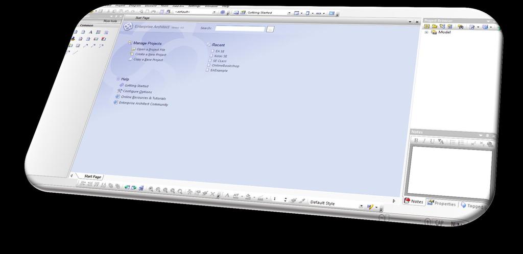
7 High Level Software Architecture
8 Weather Station System Software Embedded software but not real-time in the sense that rapid reaction to events is required. Developed using an object-oriented approach Object Oriented approach associates objects with the physical entities in the system e.g. Weather data collection instruments Power supply and generation Communications Data may be stored as objects No requirement for large-scale database
9 Weather Station System Software Each weather station is battery-powered and must be entirely self-contained there is no external power or network cables available. All communications are through a relatively slow speed satellite link and the weather station must include some mechanism (solar or wind power) to charge its batteries. As they are deployed in wilderness areas, they are exposed to severe environmental conditions and may be damaged by animals. The station software is therefore not just concerned with data collection. It must also: 1. Monitor the instruments, power and communication hardware and report faults to the management system. 2. Manage the system power, ensuring that batteries are charged whenever the environmental conditions permit but also that generators are shut down in potentially damaging weather conditions, such as high wind. 3. Allow for dynamic reconfiguration where parts of the software are replaced with new versions and where backup instruments are switched into the system in the event of system failure.


10

11

12 Creating New Project 1. Click menu 2. New project 3. Choose save file location. Ex: C:\Users\Desktop\SOFTW ARE ENGINEERING\EA

13 New Project 1 Tick : i. Requirement ii. Use Case iii. Domain model iv. Class v. Component Click OK 2

14 New Project Project browser upper right


15 Create Requirement Model Functional Requirement Click to view/ expand Double click delete all the automatically generated package by right click and choose delete

16 Adding Package Double click on functional requirement Click on Package 3. Click anywhere on diagram view 4. Fill meaningful name for the package. 5. Click OK button.


17 Adding requirement into functional requirement package 1 3 Click on REQ01- Collecting Weather Data 1. Click Requirement 2. Click anywhere on diagram view 3. Fill meaningful name for the requirement 4. Click OK button 2 5. REPEAT THE SAME STEP UNTIL ALL THE REQUIREMENT IS COMPLETE 4


18 Complete Example of functional Requirement Diagram.

19 Creating Non- Functional Requirement a 1. Click on to expand 2. Click on Non-Functional to expand 3. Double click on Non-Functional Requirements. There will be some package auto generated. 4. Right Click on each of generated package and choose DELETE d c Add Package a. Click Package b. Click anywhere in the diagram view c. Fill in meaningful name for package d. Click OK button b


20 Adding Package on Non-Functional Requirement Diagram Click

21 Example Final view of Requirement Model Diagram


22 Creating The Use Case Model
23 Relationships: Association relationship: to show the relationship between a use case and an actor There are three types of relationships between use cases: includes relationship extends relationship generalization relationship There is only one relationship allowed between actors = generalization relationship

24 Create Use Case Model To Add Actor 1. Click on Actor 2. Click anywhere in the diagram 3. Put Meaningful name 4. Click OK

25 Create Use Case Model To Add Use Case 1. Click on Use Case 3. Put Meaningful name 2. Click anywhere in the diagram 4. Click OK

26 Create Use Case Model 1 2 To Add Use Case 1. Click on Association relationship/ Choose suitable relationship in Use Case Relationship Panel 2. Click and Drag the pointer/curser from actor to the suitable use case

27 Complete of Use Case Diagram 1 2
An object-oriented design process. Weather system description. Layered architecture. Process stages. System context and models of use
 An object-oriented design process Process stages Structured design processes involve developing a number of different system models. They require a lot of effort for development and maintenance of these
WeatherHub2 Quick Start Guide
 WeatherHub2 Quick Start Guide Table of Contents 1 Introduction... 1 2 Packing List... 1 3 Connections... 1 4 IP Addressing... 2 5 Browser Access... 3 6 System Info... 3 7 Weather Station Settings... 4
Bloomsburg University Weather Viewer Quick Start Guide. Software Version 1.2 Date 4/7/2014
 Bloomsburg University Weather Viewer Quick Start Guide Software Version 1.2 Date 4/7/2014 Program Background / Objectives: The Bloomsburg Weather Viewer is a weather visualization program that is designed
O P E R A T I N G M A N U A L
 OPERATING MANUAL WeatherJack OPERATING MANUAL 1-800-645-1061 The baud rate is 2400 ( 8 bits, 1 stop bit, no parity. Flow control = none) To make sure the unit is on line, send an X. the machine will respond
Studying Topography, Orographic Rainfall, and Ecosystems (STORE)
") Introduction Studying Topography, Orographic Rainfall, and Ecosystems (STORE) Lesson: Using ArcGIS Explorer to Analyze the Connection between Topography, Tectonics, and Rainfall GIS-intensive Lesson This
Introduction Studying Topography, Orographic Rainfall, and Ecosystems (STORE) Lesson: Using ArcGIS Explorer to Analyze the Connection between Topography, Tectonics, and Rainfall GIS-intensive Lesson This
McIDAS-V Tutorial Displaying Point Observations from ADDE Datasets updated July 2016 (software version 1.6)
") McIDAS-V Tutorial Displaying Point Observations from ADDE Datasets updated July 2016 (software version 1.6) McIDAS-V is a free, open source, visualization and data analysis software package that is the
McIDAS-V Tutorial Displaying Point Observations from ADDE Datasets updated July 2016 (software version 1.6) McIDAS-V is a free, open source, visualization and data analysis software package that is the
Quick Start Guide New Mountain Visit our Website to Register Your Copy (weatherview32.com)
") Quick Start Guide New Mountain Visit our Website to Register Your Copy (weatherview32.com) Page 1 For the best results follow all of the instructions on the following pages to quickly access real-time
Quick Start Guide New Mountain Visit our Website to Register Your Copy (weatherview32.com) Page 1 For the best results follow all of the instructions on the following pages to quickly access real-time
Module 11: Meteorology Topic 3 Content: Weather Instruments Notes
 Introduction In order for meteorologists to accurately predict the weather, they take thousands of different weather measurements each day. Meteorologists need to use many tools in order to draw an accurate
You w i ll f ol l ow these st eps : Before opening files, the S c e n e panel is active.
 You w i ll f ol l ow these st eps : A. O pen a n i m a g e s t a c k. B. Tr a c e t h e d e n d r i t e w i t h t h e user-guided m ode. C. D e t e c t t h e s p i n e s a u t o m a t i c a l l y. D. C
WeatherWatcher ACP. Astronomers Control Panel (V4 or >) Ambient Virtual Weather Station (Pro or Internet editions) ASCOM platform v4.
 Ambient Virtual Weather Station (Pro or Internet editions) ASCOM platform v4.") WeatherWatcher ACP Software This is a minimum equipment list: Astronomers Control Panel (V4 or >) Ambient Virtual Weather Station (Pro or Internet editions) ASCOM platform v4.1 or higher Hardware Weather
WeatherWatcher ACP Software This is a minimum equipment list: Astronomers Control Panel (V4 or >) Ambient Virtual Weather Station (Pro or Internet editions) ASCOM platform v4.1 or higher Hardware Weather
Product Description. 1 of 6
 Product Description The 6250 Vantage Vue Wireless Weather Station provides accurate, reliable weather monitoring in a self-contained, easy-to-install system. Designed to provide the weather data you need
Development of a Remote Automatic Weather Station with a PCbased
 , pp.233-24 http://dx.doi.org/1.14257/ijhit.14.7.1.19 Development of a Remote Automatic Weather Station with a PCbased Data Logger Roneel V. Sharan School of Engineering and Physics, University of the
University of Colorado Denver Anschutz Medical Campus Online Chemical Inventory System User s Manual
 University of Colorado Denver Anschutz Medical Campus Online Chemical Inventory System User s Manual Hazardous Materials Division 303-724-0345 chemical.inventory@ucdenver.edu May, 2017 Table of Contents
Geographical Information Systems
 Geographical Information Systems Geographical Information Systems (GIS) is a relatively new technology that is now prominent in the ecological sciences. This tool allows users to map geographic features
Mini Environmental Quality Meter
 Mini Environmental Quality Meter 850027 Mini Environmental Quality Meter 850027 Copyright 2012 by Sper Scientific ALL RIGHTS RESERVED Printed in the USA The contents of this manual may not be reproduced
1. Open IDV. There is a desktop link, choose version 3.0u1 or 3.0u2. It can take a few minutes to open.
 Page 1 Objectives: Become familiar with using a software package (IDV) to view satellite images Understand the differences between Visible, IR, and Microwave Imagery Observe the influence of dry air and
Technical Procedure for Glass Refractive Index Measurement System 3 (GRIM 3)
") Technical Procedure for Glass Refractive Index Measurement System 3 (GRIM 3) 1.0 Purpose - This technical procedure shall be followed for the operation of the GRIM 3. 2.0 Scope - This procedure applies
Technical Procedure for Glass Refractive Index Measurement System 3 (GRIM 3) 1.0 Purpose - This technical procedure shall be followed for the operation of the GRIM 3. 2.0 Scope - This procedure applies
Predicting Weather Conditions. Do you have a career as a meteorologist?
 Predicting Weather Conditions Do you have a career as a meteorologist? It is essential for students for know 1. Weather conditions and patterns can be based on weather data collected from various sources.
OASIS WIRELESS WEATHER STATION
 User Manual 3910-B Royal Avenue, Simi Valley, Ca 93063 805-527-4498 RMIS Part No. 500760 TABLE OF CONTENTS INTRODUCTION General Description 3 General Precautions 3 INSTALLATION Base Preparation 6 Tower
Non-Acoustical Inputs
 CHAPTER 18 Non-Acoustical Inputs This chapter discusses the use of external transducers and devices to provide non-acoustical data to the Model 831. Included are the following: 831-INT 831-INT Interface
Appendix F. + 1 Ma 1. 2 Ma Ma Ma ln + K = 0 (4-173)
") 5:39p.m. Page:949 Trimsize:8.5in 11in Appendix F F.1 MICROSOFT EXCEL SOLVER FOR NON-LINEAR EQUATIONS The Solver is an optimization package that finds a maximum, minimum, or specified value of a target
5:39p.m. Page:949 Trimsize:8.5in 11in Appendix F F.1 MICROSOFT EXCEL SOLVER FOR NON-LINEAR EQUATIONS The Solver is an optimization package that finds a maximum, minimum, or specified value of a target
WEATHER STATION FOR SOLAR FARM MONITORING
 WEATHER STATION FOR SOLAR FARM MONITORING SOLAR FARM MONITORING SYSTEM: Measures global, horizontal, & background irradiance. Measures wind speed, wind direction, ambient temperature, and relative humidity.
HOW TO GUIDE. Loading climate data from online database
 HOW TO GUIDE Loading climate data from online database Copyright and publisher: EMD International A/S Niels Jernes vej 10 9220 Aalborg Ø Denmark Phone: +45 9635 44444 e-mail: emd@emd.dk web: www.emd.dk
Chapter 2 Agro-meteorological Observatory
 Chapter 2 Agro-meteorological Observatory Abstract A Meteorological observatory is an area where all the weather instruments and structures are installed. The chapter gives a description of a meteorological
BERMAD Irrigation. BIC2000 Weather Station SYSTEM GUIDE VERSIONS : BIC ; PC 4.90
 BIC2000 Weather Station SYSTEM GUIDE VERSIONS : BIC2000 3.92; PC 4.90 CONTENTS 1. SYSTEM OVERVIEW 3 2. WEATHER STATION SETUP 4 2.1 ISS AND CONSOLE SETUP 4 2. RF RTU SYSTEM SETUP 5 2.2 BIC2000 WEATHER STATION
Overlaying GRIB data over NOAA APT weather satellite images using OpenCPN
 Overlaying GRIB data over NOAA APT weather satellite images using OpenCPN I receive NOAA weather satellite images which are quite useful when used alone but with GRIB wind and rain data overlaid they can
Circular Motion and Centripetal Force
 [For International Campus Lab ONLY] Objective Measure the centripetal force with the radius, mass, and speed of a particle in uniform circular motion. Theory ----------------------------- Reference --------------------------
Contour Line Overlays in Google Earth
 Overview: Students download a section of a topographic map of their community from the ATEP website. This file will overlay the Google Earth satellite imagery. Students use the path tool to trace a contour
SIMBAD RADIOMETER - INSTRUCTIONS
 SIMBAD RADIOMETER - INSTRUCTIONS The SIMBAD radiometer measures direct sunlight intensity by viewing the sun, and water-leaving radiance by viewing the ocean surface at 45 degrees from nadir and 135 degrees
Weather Monitoring Station Features Easy Wireless Installation and Solar Power
 Subject: OSI CableFree Weather Station (WMR-918) (http://www.oregonscientific.com/wmr91 CableFree Weather Station Model WMR-918 CableFree Weather Station Weather Monitoring Station Features Easy Wireless
SteelSmart System Cold Formed Steel Design Software Download & Installation Instructions
 Step 1 - Login or Create an Account at the ASI Portal: Login: https://portal.appliedscienceint.com/account/login Create Account: https://portal.appliedscienceint.com/account/register 2 0 1 7 A p p l i
FireFamilyPlus Version 5.0
 FireFamilyPlus Version 5.0 Working with the new 2016 NFDRS model Objectives During this presentation, we will discuss Changes to FireFamilyPlus Data requirements for NFDRS2016 Quality control for data
Forecast Models. General Meteorology Laboratory #11
 General Meteorology Laboratory #11 Name Partners Forecast Models Date _ Section Purpose: Develop the ability to contour two dimensional data and use the resulting information to locate a cold front. Equipment:
SOFTWARE USER MANUAL. Weather Capture Advance WS1640 WM9280
 SOFTWARE USER MANUAL Weather Capture Advance WS1640 WM9280 1 TABLE OF CONTENTS 1. Introduction 3 1.1 System requirements 1.2 Connection of the weather station 1.3 Installation of the Weather Capture Advance
For Military, Research, Tactical Portable Vehicle Mount Fixed Base
 For Military, Research, Military & Commercial Weather Applications Stations Tactical Portable Vehicle Mount Fixed Base WEATHERPAK Marine Weather Stations for Harsh Environments WEATHERPAK marine weather
Weather Stations. Evaluation copy. 9. Post live weather data on the school s web site for students, faculty and community.
 Weather Stations Computer P6 Collecting and analyzing weather data can be an important part of your Earth Science curriculum. It might even be an ongoing part of your entire course. A variety of activities
: : User Manual: : - 10 December
 : : User Manual: : - 0 December 06 - : : User Manual: : Table of Contents. Map Control. How to move a map. How to zoom in and out a map 4. How to inquire Ocean Currents. How to inquire predicted current
Website Phone Mobile OVERVIEW Davis Vantage Pro2 Weather Station
 OVERVIEW If you're looking for a superior weather station, the Davis Vantage Pro2 Weather Station is as good as they come! Vantage Pro2 offers the professional weather observer and the serious weather
William H. Bauman III * NASA Applied Meteorology Unit / ENSCO, Inc. / Cape Canaveral Air Force Station, Florida
 12.5 INTEGRATING WIND PROFILING RADARS AND RADIOSONDE OBSERVATIONS WITH MODEL POINT DATA TO DEVELOP A DECISION SUPPORT TOOL TO ASSESS UPPER-LEVEL WINDS FOR SPACE LAUNCH William H. Bauman III * NASA Applied
Structure Monitoring Technology. Features. Ordering Information. Trigger Tape. A2 Pulse Counter (Optional) Solar Radiation Sensor
 Solar Radiation Sensor") Rain detection sensor General Description Driving rain and its effective management are critical factors in determining the durability of building enclosures. An accurate measurement of driving rain can
Rain detection sensor General Description Driving rain and its effective management are critical factors in determining the durability of building enclosures. An accurate measurement of driving rain can
PAM-Station Land-Owner Information Guide Project: CuPIDO, Tucson AZ, Jul/Aug 2006
 PAM-Station Land-Owner Information Guide Project: CuPIDO, Tucson AZ, Jul/Aug 2006 PropVane Anemometer mounted at 10-m Lightning Spike Two-Way radio antenna Sonic Anemometer Solar and Net Radiation sensors.
Instruction Manual. Solar Weather Centre With Wireless Weather Vane. Product Code: WS5056C. Solar Powered Outdoor Weather Data Collector
 Solar Weather Centre With Wireless Weather Vane Solar Powered Outdoor Weather Data Collector Indoor Receiver Instruction Manual Product Code: WS5056C TECHNICAL DETAILS Thank you for purchasing the Holman
LOG_aLevel. Tsunami Warning System
 LOG_aLevel Tsunami Warning System General Acoustics e.k. Am Kiel-Kanal 1 24106 Kiel Germany Phone: +49 431 5 80 81 80 www.generalacoustics.com Info@generalacoustics.com LOG_aLevel Tsunami Warning System
Location Intelligence Infrastructure Asset Management. Confirm. Confirm Mapping Link to ArcMap Version v18.00b.am
 Location Intelligence Infrastructure Asset Management Confirm Confirm Mapping Link to ArcMap Version v18.00b.am Information in this document is subject to change without notice and does not represent a
Applications. Remote Weather Station with Telephone Communications. Tripod Tower Weather Station with 4-20 ma Outputs
 Tripod Tower Weather Station with 4-20 ma Outputs Remote Weather Station with Telephone Communications NEMA-4X Enclosure with Two Translator Boards and Analog Barometer Typical Analog Output Evaporation
WeatherHawk Weather Station Protocol
 WeatherHawk Weather Station Protocol Purpose To log atmosphere data using a WeatherHawk TM weather station Overview A weather station is setup to measure and record atmospheric measurements at 15 minute
South Bay Coastal Ocean Observing System California Clean Beaches Initiative
 South Bay Coastal Ocean Observing System California Clean Beaches Initiative Third Quarterly Report April, 2003 to City of Imperial Beach Eric Terrill 1 1 Scripps Institution of Oceanography, University
Labdisc Activity A Walk in the Park
 Labdisc Activity A Walk in the Park Supporting Labdisc Data Logger, GlobiWorld and GlobiLab Software For Elementary School Science A Walk in the Park Introduction We can find green parks in almost every
Flight Utilities Metar Reader version 3.1 by Umberto Degli Esposti
 Flight Utilities http://www.flightutilities.com Metar Reader version 3.1 by Umberto Degli Esposti 1 Description The program allows inserting a Metar, to load it from a disk or from internet and to show
Skin Damage Visualizer TiVi60 User Manual
 Skin Damage Visualizer TiVi60 User Manual PIONEERS IN TISSUE VIABILITY IMAGING User Manual 3.2 Version 3.2 October 2013 Dear Valued Customer! TiVi60 Skin Damage Visualizer Welcome to the WheelsBridge Skin
General Meteorology Laboratory #11. Forecast Models
 General Meteorology Laboratory #11 Name Partners Forecast Models Date _ Section Purpose: Develop the ability to contour two dimensional data and use the resulting information to locate a cold front. Equipment:
James P. Koermer * Plymouth State College Plymouth, New Hampshire
 5.5 THE PSC WEATHER CENTER WEB PORTAL James P. Koermer * Plymouth State College Plymouth, New Hampshire 1. INTRODUCTION The Plymouth State College (PSC) Weather Center web page went online in April 1994
Building Inflation Tables and CER Libraries
 Building Inflation Tables and CER Libraries January 2007 Presented by James K. Johnson Tecolote Research, Inc. Copyright Tecolote Research, Inc. September 2006 Abstract Building Inflation Tables and CER
Molecular Modeling and Conformational Analysis with PC Spartan
 Molecular Modeling and Conformational Analysis with PC Spartan Introduction Molecular modeling can be done in a variety of ways, from using simple hand-held models to doing sophisticated calculations on
Enabling ENVI. ArcGIS for Server
 Enabling ENVI throughh ArcGIS for Server 1 Imagery: A Unique and Valuable Source of Data Imagery is not just a base map, but a layer of rich information that can address problems faced by GIS users. >
Eppendorf Temperature Verification System. Operating manual /0909
 Eppendorf Temperature Verification System 6328 900.066-00/0909 Copyright 2009 Eppendorf AG, Hamburg. No part of this publication may be reproduced without the prior permission of the copyright owner. eppendorf
Quality assurance for sensors at the Deutscher Wetterdienst (DWD)
") Paper submitted to ICAWS 2017: Topic 3 Sustainability of the measurements: Calibration, intercomparisons, laboratory and field performance tests, quality assurance and control assessment for traceable
Paper submitted to ICAWS 2017: Topic 3 Sustainability of the measurements: Calibration, intercomparisons, laboratory and field performance tests, quality assurance and control assessment for traceable
Programs of Regione Campania for reduction of seismic risk (and others)
") Programs of Regione Campania for reduction of seismic risk (and others) 2011-10151015 Prof ing Edoardo Cosenza Assessore (Regional Ministry) Public Works and Civil Protection Regione Campania Napoli, 1900.
Programs of Regione Campania for reduction of seismic risk (and others) 2011-10151015 Prof ing Edoardo Cosenza Assessore (Regional Ministry) Public Works and Civil Protection Regione Campania Napoli, 1900.
ON SITE SYSTEMS Chemical Safety Assistant
 ON SITE SYSTEMS Chemical Safety Assistant CS ASSISTANT WEB USERS MANUAL On Site Systems 23 N. Gore Ave. Suite 200 St. Louis, MO 63119 Phone 314-963-9934 Fax 314-963-9281 Table of Contents INTRODUCTION
Synteny Portal Documentation
 Synteny Portal Documentation Synteny Portal is a web application portal for visualizing, browsing, searching and building synteny blocks. Synteny Portal provides four main web applications: SynCircos,
A Rain Sensitive House Window Closes Automatically When Raining
 A Rain Sensitive House Window Closes Automatically When Raining House windows are sometimes opened when it rains and no body around to close them allowing rain going in side and damage the house. Information
Creating Satellite Orbits
 Exercises using Satellite ToolKit (STK) vivarad@ait.ac.th Creating Satellite Orbits 1. What You Will Do Create a low-earth orbit (LEO) satellite Create a medium-earth orbit (MEO) satellite Create a highly
An area chart emphasizes the trend of each value over time. An area chart also shows the relationship of parts to a whole.
 Excel 2003 Creating a Chart Introduction Page 1 By the end of this lesson, learners should be able to: Identify the parts of a chart Identify different types of charts Create an Embedded Chart Create a
What are the Spatial Data Standards?
 What is SDSFIE? 1992 Army, Navy, Air Force and Marine Corps established the Tri- Service CADD/GIS Technology Center at the US Army Engineer Waterways Experiment Station in Vicksburg, Miss. 1999 name was
Application Note. U. Heat of Formation of Ethyl Alcohol and Dimethyl Ether. Introduction
 Application Note U. Introduction The molecular builder (Molecular Builder) is part of the MEDEA standard suite of building tools. This tutorial provides an overview of the Molecular Builder s basic functionality.
Urban Dispersion Program New York City Mesonet ROOFTOP WEATHER STATION NETWORK
 Urban Dispersion Program New York City Mesonet ROOFTOP WEATHER STATION NETWORK GENERAL DESCRIPTION Introduction The Department of Homeland Security has established a meteorological research program in
Fog Monitor 100 (FM 100) Extinction Module. Operator Manual
 Extinction Module. Operator Manual") Particle Analysis and Display System (PADS): Fog Monitor 100 (FM 100) Extinction Module Operator Manual DOC-0217 Rev A-1 PADS 2.7.3, FM 100 Extinction Module 2.7.0 5710 Flatiron Parkway, Unit B Boulder,
Particle Analysis and Display System (PADS): Fog Monitor 100 (FM 100) Extinction Module Operator Manual DOC-0217 Rev A-1 PADS 2.7.3, FM 100 Extinction Module 2.7.0 5710 Flatiron Parkway, Unit B Boulder,
Become a Microprobe Power User Part 2: Qualitative & Quantitative Analysis
 Become a Microprobe Power User Part 2: Qualitative & Quantitative Analysis Mike Spilde Spring IOM Seminar February 5, 2008 Qualitative Analysis Why use qualitative scans? Elemental ID (especially trace
Quality assurance for sensors at the Deutscher Wetterdienst (DWD)
") Quality assurance for sensors at the Deutscher Wetterdienst (DWD) Quality assurance / maintenance / calibration Holger Dörschel, Dr Tilman Holfelder WMO International Conference on Automatic Weather Stations
Quality assurance for sensors at the Deutscher Wetterdienst (DWD) Quality assurance / maintenance / calibration Holger Dörschel, Dr Tilman Holfelder WMO International Conference on Automatic Weather Stations
Degree-days and Phenology Models
 Page 1 of 14 Degree-days and Phenology Models Using the UC IPM Degree-day Calculator Specify source of temperature data Data from UC IPM weather database Data from your file Data you enter online Run models
Quality Assurance and Quality Control
 Quality Assurance and Quality Control of Surface Observations in JMA Japan Meteorological Agency Hakaru MIZUNO "Guide to Meteorological Instruments and Methods of Observation", WMO-No.8, 7th ed., 2008.
WEATHERPAK MTR Training Guide
 WEATHERPAK MTR Coastal Environmental Systems, Inc. 820 First Avenue South Seattle, WA 98134 206.682.6048 800.488.8291 206.682.5658 Fax www.coastalenvironmental.com 11-15-2012 WEATHERPAK is the #1 Choice
Virtual Weather Station Version 12 User's Manual
 Virtual Weather Station Version 12 User's Manual For Davis Instruments Vantage, Vantage Pro, Weather Monitor II, Weather Wizard III, Oregon Scientific WMR-918 (cable free), Oregon Scientific WMR-968 (cable
Digital Stored Grain Quality Management. BinMaster Level Controls Lincoln, Nebraska, USA
 Digital Stored Grain Quality Management BinMaster Level Controls Lincoln, Nebraska, USA Why monitor stored grain? Early detection protects against losses Reduce shrink to maximize grain weight and profit
Lecture 2. Introduction to ESRI s ArcGIS Desktop and ArcMap
 Lecture 2 Introduction to ESRI s ArcGIS Desktop and ArcMap Outline ESRI What is ArcGIS? ArcGIS Desktop ArcMap Overview Views Layers Attribute Tables Help! Scale Tips and Tricks ESRI Environmental Systems
Presenting Tree Inventory. Tomislav Sapic GIS Technologist Faculty of Natural Resources Management Lakehead University
 Presenting Tree Inventory Tomislav Sapic GIS Technologist Faculty of Natural Resources Management Lakehead University Suggested Options 1. Print out a Google Maps satellite image of the inventoried block
Ocean Optics Red Tide UV-VIS Spectrometer (Order Code: SPRT-UV-VIS)
") Ocean Optics Red Tide UV-VIS Spectrometer (Order Code: SPRT-UV-VIS) The UV-VIS spectrometer is a portable ultraviolet light and visible light spectrophotometer, combining a spectrometer and a light source/cuvette
Ocean Optics Red Tide UV-VIS Spectrometer (Order Code: SPRT-UV-VIS) The UV-VIS spectrometer is a portable ultraviolet light and visible light spectrophotometer, combining a spectrometer and a light source/cuvette
Geo-enabling a Transactional Real Estate Management System A case study from the Minnesota Dept. of Transportation
 Geo-enabling a Transactional Real Estate Management System A case study from the Minnesota Dept. of Transportation Michael Terner Executive Vice President Co-author and Project Manager Andy Buck Overview
473 Dew Point Hygrometer
 gh Performance Chilled Hygrometer With Cable Mounted Measuring Heads ghly precise chilled mirror dew point technology Cable mounted dew point and temperature measurement Aspirated and direct insertion
Forecast.io Driver. Installation and Usage Guide. Revision: 1.0 Date: Tuesday, May 20, 2014 Authors: Alan Chow
 Forecast.io Driver Installation and Usage Guide Revision: 1.0 Date: Tuesday, May 20, 2014 Authors: Alan Chow Contents Overview... 2 Features... 3 Usage Scenarios... 4 Change Log... 4 Disclaimer... 4 Driver
DATA SOURCES FOR A MODEL TO PREDICT AIR TEMPERATURES INSIDE A RESIDENTIAL HOME
 DATA SOURCES FOR A MODEL TO PREDICT AIR TEMPERATURES INSIDE A RESIDENTIAL HOME N Bausch Systems Engineering Research Group, School of Engineering, University of Portsmouth, PO1 3DJ. Email: nils.bausch@port.ac.uk
MODE button MAX/MIN button CHANNEL button / C/ F / RCC button SNOOZE / LIGHT button Battery compartment A/C in-jack 3. 4.
 KL4912 Desktop weather station Instruction Manual Introduction This weather station comes with backlight, indoor and outdoor temperature & humidity display, and alarm clock with calendar. Fig. 1 Front
Instituto de Pesquisas Meteorológicas - IPMet Universidade Estadual Paulista - Unesp
 IPMET WEB GIS APPLICATION FOR SEVERE WEATHER ALERT AND DECISION SUPPORT Jaqueline Murakami Kokitsu Instituto de Pesquisas Meteorológicas - IPMet Universidade Estadual Paulista - Unesp IPMet/Unesp Meteorological
Guide to Hydrologic Information on the Web
 NOAA s National Weather Service Guide to Hydrologic Information on the Web Colorado River at Lees Ferry Photo: courtesy Tim Helble Your gateway to web resources provided through NOAA s Advanced Hydrologic
Measuring ph with Smart Cuvettes
 1 Measuring ph with Smart Cuvettes Hardware Setup for ph Measurements ph is measured in Absorbance mode. Configure your spectroscopy components for Absorbance measurements. Sample Absorbance setups for
EAS 535 Laboratory Exercise Weather Station Setup and Verification
 EAS 535 Laboratory Exercise Weather Station Setup and Verification Lab Objectives: In this lab exercise, you are going to examine and describe the error characteristics of several instruments, all purportedly
Training Guide. Coastal Environmental Systems, Inc.
 WEATHERPAK TRx2 Coastal Environmental Systems, Inc. 820 First Avenue South Seattle, WA 98134 206.682.6048 800.488.8291 206.682.5658 Fax www.coastalenvironmental.com 11-16-2012 WEATHERPAK is the #1 Choice
MAPPING OF BLACK POPLARS
 MAPPING OF BLACK POPLARS Contribution to conservation of Black Poplars Monitoring and recording of trees: mapping, tagging and photographing black poplars. Updating the database with current data, including
Introduction to Google Drive Objectives:
 Introduction to Google Drive Objectives: Learn how to access your Google Drive account Learn to create new documents using Google Drive Upload files to store on Google Drive Share files and folders with
1 Introduction. Station Type No. Synoptic/GTS 17 Principal 172 Ordinary 546 Precipitation
 Use of Automatic Weather Stations in Ethiopia Dula Shanko National Meteorological Agency(NMA), Addis Ababa, Ethiopia Phone: +251116639662, Mob +251911208024 Fax +251116625292, Email: Du_shanko@yahoo.com
HOW TO ANALYZE SYNCHROTRON DATA
 HOW TO ANALYZE SYNCHROTRON DATA 1 SYNCHROTRON APPLICATIONS - WHAT Diffraction data are collected on diffractometer lines at the world s synchrotron sources. Most synchrotrons have one or more user facilities
Energy. This provides a practical measure of the usefulness of a machine. The useful energy transfer in a generator can be represented by:
 Sensors: Loggers: Voltage, Current, Motion Any EASYSENSE Physics Logging time: 10 seconds 44a Efficiency of an electric generator Read Machines use energy transfers to achieve a useful job of work. No
MAGMA NOTE! 21+ USER MANUAL
 21+ MAGMA USER MANUAL NOTE! Please do not put this product away or leave it for extended periods of time with low charge because if the battery falls below 2% then it will no longer accept a charge. Thank
Learning ArcGIS: Introduction to ArcCatalog 10.1
 Learning ArcGIS: Introduction to ArcCatalog 10.1 Estimated Time: 1 Hour Information systems help us to manage what we know by making it easier to organize, access, manipulate, and apply knowledge to the
Correcting Real Time Automatic Weather Stations Data Through Quality Checks and Analysis
 Correcting Real Time Automatic Weather Stations Data Through Quality Checks and Analysis Sd. Thouseef Ahmed Shoaib and Syed Nayab Rasool Andhra Pradesh State Development Planning Society, Hyderabad Email:
SOFTWARE. Control of the AMS SYSTEM CONTROL AND MONITORING OF AIRFIELD GROUND LIGHTING EQUIPMENT
 Control of the AMS SYSTEM SOFTWARE CONTROL AND MONITORING OF AIRFIELD GROUND LIGHTING EQUIPMENT Description of function airfield ground lighting equipment are shown on the screen representing the airport
GREAT EXPERIENCE IN MONITORING SYSTEMS CAPACITY ON DEVELOPMENT AND CREATING SOLUTIONS ADVANCED ITALIAN TECHNOLOGY
 GREAT EXPERIENCE IN MONITORING SYSTEMS CAPACITY ON DEVELOPMENT AND CREATING SOLUTIONS ADVANCED ITALIAN TECHNOLOGY NESA Srl Via Sartori 6/8 31020 Vidor (TV) Italy www.nesasrl.it info@nesasrl.it Quality
for JMA/WMO Training Workshop on CALIBRATION AND MAINTENANCE OF METEOROLOGICAL INSTRUMENTS
 for JMA/WMO Training Workshop on CALIBRATION AND MAINTENANCE OF METEOROLOGICAL INSTRUMENTS in RA II (ASIA) 0. Overview of JMA 3 4 1. Surface observation station 5-8 2. Instruments in operational use 9-14
Low Cost Weather Stations for Developing Countries (Kenya)
") Low Cost Weather Stations for Developing Countries (Kenya) Charles Mwangi Kenya Space Agency 7 th UNSPIDER Conference 23th-25th October 2017 Prepared with support of: Martin Steinson/Paul Kucera - UCAR/NCAR
Low Cost Weather Stations for Developing Countries (Kenya) Charles Mwangi Kenya Space Agency 7 th UNSPIDER Conference 23th-25th October 2017 Prepared with support of: Martin Steinson/Paul Kucera - UCAR/NCAR