Jason Bentley Ashe Prelim_Research_Notebook_Data MDS_I Fall_2007
|
|
|
- Juniper Higgins
- 5 years ago
- Views:
Transcription
1 Jason Bentley Ashe Prelim_Research_Notebook_Data MDS_I Fall_2007 Theory Section: This section will be coming very soon, due to the change in my project. Quotes: Explanation: Application to your Thesis : State your Thesis and its Linkage to the Referenced Theories: Case Studies of Facilities based on these Theories: Facility Section: This section will be coming very soon, due to the change in my project. Discuss Building Type: History of Building Types/Evolution of Building Types: Case Studies of Facilities With Similar Use: Discover necessary space needs, and spatial requirements for this type of facility in your particular location Determine Capacities: Determine Specific Technical Needs: (i.e. Special HVAC, Lighting Requirements) Context Section Site: Saluda, South Carolina (Saluda County) o Saluda was named for an Indian Tribe and is located in the Piedmont Region of South Carolina. o The county has an area of 452 square miles and has a population of 19,000 o Saluda is a rural county within commuting distance of larger urban centers such as Columbia, SC and Augusta, GA. o Growth is occurring along the eastern part of the county adjacent to Lake Murray and in the southern portion with infrastructure and proximity to an interstate. o Most of the county land uses range from small towns to prime farmlands. Maps of Area: See Below. Plats of the site: o o Dimensions: Included in the PDF files listed above. Drainage problems: Coming Soon. Utility locations: Coming Soon. Photographs of Site: Coming Soon. Photos of regional architecture, neighboring structures: Coming Soon. Determine circulation paths: Coming Soon.

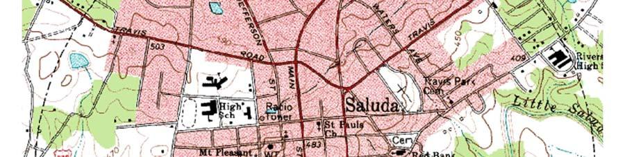
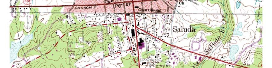
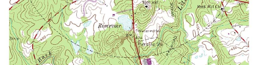

2 Determine noise generators and locations: Coming Soon. Topography

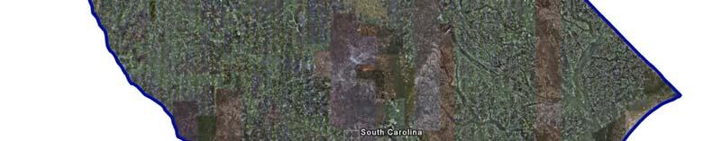


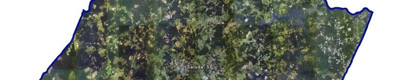
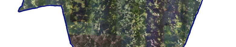

3 Aerial photographs The State of South Carolina Saluda County, South Carolina
, where 8.4 km² (3.2 mi²) is land and 0.1 km² (0.04 mi²) or (1.")
 o Elevation: 479 Feet o Eastern Standard Time zone.")

 o Greenwood County (Northwest) Location to nearby southeast cities Distance Miles")
4 The City of Saluda, Saluda County, South Carolina Demographics of the Area: o Total Area: 8.5 km² (3.3 mi²), where 8.4 km² (3.2 mi²) is land and 0.1 km² (0.04 mi²) or (1.22%) is water o Latitude: N (34.001N) / Longitude: W ( W) o Elevation: 479 Feet o Eastern Standard Time zone. Determine Clients/Users: The facility will be located in the city of Saluda, but will serve all of Saluda County and possibly the some of the neighboring counties, which include: o Newberry County (North) o Lexington County (East) o Aiken County (South) o Edgefield County (Southwest) o Greenwood County (Northwest) Location to nearby southeast cities Distance Miles Kilometers Drive Time Greenwood, SC mins. Lexington, SC mins.
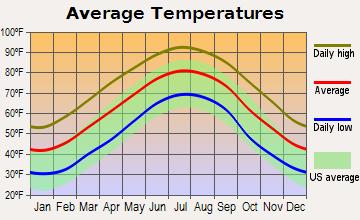
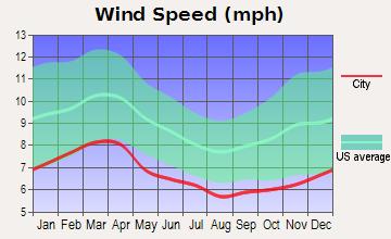
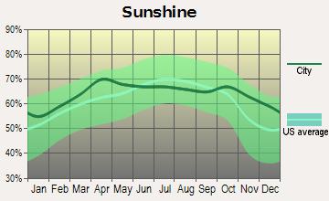
5 Augusta, GA mins. Columbia, SC mins. Spartanburg, SC hr. 30 mins. Greenville, SC hr. 40 mins. Charlotte, NC hr. 40 mins. Charleston, SC hrs. 40 mins. Atlanta, GA hrs. 20 mins. Savannah, GA hrs. 45 mins. Attitudes and Aspirations of the Citizens and Users: o According to some of people I have talked to in the community, talks about acquiring a general full-service hospital has become one of the main interests with in the county. Zoning Ordinances o No zoning requirements are currently in place, but Saluda County, SC is currently soliciting Request for Proposals (RFP) for a comprehensive plan and zoning ordinance with maps. ADA Requirements o The 1998 ICC/ANSI A117.1, Accessible and Useable Buildings and Facilities, is adopted by the Accessibility Act and mandatory for use in all jurisdictions within the state. Design Guidelines o 2003 International Building Code with SC modifications o 2003 International Fire Code with SC modifications o 2003 International Plumbing Code o 2003 International Mechanical Code o 2003 International Energy Conservation Code o 2003 International Residential Code with SC modifications o 2003 International Fuel Gas Code with SC modifications o 2005 National Electrical Code o The Building Energy Efficiency Standards Act is adopted by statute and mandatory for use in all jurisdictions within the state. Vegetation or lack thereof: Coming Soon. Soil types: Coming Soon. Climate conditions: (Winds, temperatures - extremes, averages, rainfall, snow amounts, dust, etc.) o Average climate in Saluda, South Carolina based on data reported by over 4,000 weather stations
6
7
 tornado 21.0 miles away from the Saluda town center killed 2 people and caused between $500,000 and $5,000,000 in damages. o On 12/13/1973, a category 3 (max.")
8 o Saluda-area historical tornado activity is slightly above South Carolina state average. It is 39% greater than the overall U.S. average. o On 12/13/1973, a category 4 (max. wind speeds mph) tornado 21.0 miles away from the Saluda town center killed 2 people and caused between $500,000 and $5,000,000 in damages. o On 12/13/1973, a category 3 (max. wind speeds mph) tornado 14.0 miles away from the town center injured 26 people and caused between $500,000 and $5,000,000 in damages. History of the Site and Area/City: Case Studies: Coming Soon. Surrounding Hospitals: Hospitals Newberry County Memorial Hospital Newberry, SC Self Regional Healthcare Greenwood, SC Lexington Medical Center West Columbia, SC Augusta Veterans Administration Medical Center (GEORGIA) Augusta, GA University Healthcare System (GEORGIA) Augusta, GA Medical College of Georgia (GEORGIA) Augusta, GA Wm. Jennings Bryan Dorn Veterans Administration Medical Center (GEORGIA) Augusta, GA Palmetto Baptist Medical Center Columbia, SC Distance 26 miles 28 miles 41 miles 42 miles 42 miles 42 miles 47 miles 55 miles
9 Palmetto Health Richland Columbia, SC Providence Hospital Columbia, SC 56 miles 57 miles Resources: City Planning Departments Zoning Departments Local library
2015 South Carolina Statewide Child Care Market Rate Survey Results
 01 South Carolina Statewide Child Care Market Rate Survey Results To determine the that the SC Voucher Program (formerly ABC Voucher Program) pays enrolled child care providers, the South Carolina Department
Public Land Survey System Knowledge Remains an Important Skill
 By Douglas S. Helmke, P.G., Water Rights / Source Water Specialist Public Land Survey System Knowledge Remains an Important Skill In our new world of global positioning system (GPS) navigation, with digital
Application #: TEXT
 TOWN OF FORT MYERS BEACH 2008 PROPOSED COMPREHENSIVE PLAN AMENDMENTS Application #: 2008-13-TEXT Description: Modify the Coastal Management and Future Land Use Elements to reflect the state s new definition
Simple Solutions Social Studies Level 2. Level 2. Social Studies. Help Pages
 Level 2 Social Studies 147 148 adobe houses with bricks made of clay and straw ancestor a family member who lived before us appoint choose; leaders can appoint others barter trading one thing for another
The 2015 NWS Spring and Summer Weather Update
 http://weather.gov The 2015 NWS Spring and Summer Weather Update Western North Carolina severe weather climatology Tony Sturey, WCM Greenville/Spartanburg, SC North Carolina Spring and Summer Outlooks
Technical Memorandum #2 Future Conditions
 Technical Memorandum #2 Future Conditions To: Dan Farnsworth Transportation Planner Fargo-Moorhead Metro Council of Governments From: Rick Gunderson, PE Josh Hinds PE, PTOE Houston Engineering, Inc. Subject:
CoCoRaHS. Carolina PAGES Hurricane Matthew in South Carolina. CoCoRaHS Observers Activity During Hurricane Matthew.
 Carolina CoCoRaHS SUMMER 2017 Hurricane Matthew in South Carolina H urricane Matthew was the first South Carolina hurricane landfall since Hurricane Charley and Gaston came ashore in 2004. It made landfall
Frequently Asked Questions
 What is the Regional Transit Engagement Series? As one of the fastest growing regions in the country, there is recognition that long-term transit planning efforts should be accelerated if we are to remain
National Weather Service Greenville-Spartanburg, Forecast Office
 National Weather Service Greenville-Spartanburg, Forecast Office CoCoRaHS Presentation: NC CERT Conference May, 2017 Introduction- who we are. Federal Agency Within the U.S. Dept. of Commerce Introduction-
Erin Mack Ashley, PhD, LEED AP Diana Castro, PE
 Impact and mitigation options for residential fires following Hurricane Sandy Erin Mack Ashley, PhD, LEED AP Diana Castro, PE June 9-14, 2013 Hurricane Hazards Storm Surge Winds Heavy Rain Tornadoes FIRE?
EEC Modification Project. Initial Draft Resource Report 10 Alternatives. 569 Brookwood Village Suite 749 Birmingham, Alabama 35209
 EEC Modification Project Initial Draft Resource Report 10 Alternatives 569 Brookwood Village Suite 749 Birmingham, Alabama 35209 April 2013 INITIAL DRAFT RESOURCE REPORT 10 - ALTERNATIVES INITIAL DRAFT
STATE GEOGRAPHIC INFORMATION DATABASE
 STATE GEOGRAPHIC INFORMATION DATABASE Data Information and Knowledge Management STATE GEOGRAPHIC INFORMATION DATABASE EXECUTIVE SUMMARY Utah has developed one of the most comprehensive statewide GIS resources
World Geography. WG.1.1 Explain Earth s grid system and be able to locate places using degrees of latitude and longitude.
 Standard 1: The World in Spatial Terms Students will use maps, globes, atlases, and grid-referenced technologies, such as remote sensing, Geographic Information Systems (GIS), and Global Positioning Systems
Map Skills Test. 1. What do we call a person who makes maps? a. mapographer b. cartographer c. geologist d. archaeologist
 Map Skills Test 1. What do we call a person who makes maps? a. mapographer b. cartographer c. geologist d. archaeologist 2. What is the name of the 0 latitude line? a. Equator b. Arctic Circle c. First
INDIANAMAP VIEWING APPLICATION
 INDIANAMAP VIEWING APPLICATION (VERSION 1.0 ) Based on the 2005 Developed for the Indiana Department of Homeland Security by: IndianaMap Viewing Application Introduction The IndianaMap Viewing Application
Chippewa County Natural Hazards Mitigation Plan
 2014 Chippewa County Natural Hazards Mitigation Plan Prepared for: Chippewa County Office of Emergency Management With the Assistance of: Eastern U.P. Regional Planning & Development Commission April,
About places and/or important events Landmarks Maps How the land is, hills or flat or mountain range Connected to maps World Different countries
 What do you think you know about geography? About places and/or important events Landmarks Maps How the land is, hills or flat or mountain range Connected to maps World Different countries What do you
2 Georgia: Its Heritage and Its Promise
 TERMS region, erosion, fault, elevation, Fall Line, aquifer, marsh, climate, weather, precipitation, drought, tornado, hurricane, wetland, estuary, barrier island, swamp PLACES Appalachian Mountains, Appalachian
KANSAS CLIMATE SUMMARY June 2016
 KANSAS CLIMATE SUMMARY June 2016 Summer arrives early June made a quick turn-around with both temperature and precipitation in most of the state. Only the Southwest Division averaged above normal precipitation
Quick Response Report #126 Hurricane Floyd Flood Mapping Integrating Landsat 7 TM Satellite Imagery and DEM Data
 Quick Response Report #126 Hurricane Floyd Flood Mapping Integrating Landsat 7 TM Satellite Imagery and DEM Data Jeffrey D. Colby Yong Wang Karen Mulcahy Department of Geography East Carolina University
KANSAS CLIMATE SUMMARY June 2018
 KANSAS CLIMATE SUMMARY June 2018 Continued Heat While the heat wasn t as dramatic as in May, June still came in as the 7 th warmest since 1895. The statewide average for the month was 77.9 o F. This was
MAPS AND THEIR CLASSIFICATION
 MAPPING MAPS AND THEIR CLASSIFICATION WHAT IS A MAP? A map is representation of the Earth's surface, showing how things are related to each other by distance, direction, and size. Maps are a way of showing
KENTUCKY HAZARD MITIGATION PLAN RISK ASSESSMENT
 KENTUCKY HAZARD MITIGATION PLAN RISK ASSESSMENT Presentation Outline Development of the 2013 State Hazard Mitigation Plan Risk Assessment Determining risk assessment scale Census Data Aggregation Levels
JP 2.8 SPATIAL DISTRIBUTION OF TROPICAL CYCLONE INDUCED PRECIPITATION AND OPERATIONAL APPLICATIONS IN SOUTH CAROLINA
 JP 2.8 SPATIAL DISTRIBUTION OF TROPICAL CYCLONE INDUCED PRECIPITATION AND OPERATIONAL APPLICATIONS IN SOUTH CAROLINA R. Jason Caldwell *, Hope P. Mizzell, and Milt Brown South Carolina State Climatology
GC Briefing. Weather Sentinel Tropical Storm Michael. Status at 8 AM EDT (12 UTC) Today (NHC) Discussion. October 11, 2018
 Today (NHC) Discussion. October 11, 2018") GC Briefing Weather Sentinel Tropical Storm Michael October 11, 2018 After making landfall as a high-end category-4 hurricane on the Florida Panhandle, Michael weakened to tropical storm status early this
GC Briefing Weather Sentinel Tropical Storm Michael October 11, 2018 After making landfall as a high-end category-4 hurricane on the Florida Panhandle, Michael weakened to tropical storm status early this
Climate. Annual Temperature (Last 30 Years) January Temperature. July Temperature. Average Precipitation (Last 30 Years)
 January Temperature. July Temperature. Average Precipitation (Last 30 Years)") Climate Annual Temperature (Last 30 Years) Average Annual High Temp. (F)70, (C)21 Average Annual Low Temp. (F)43, (C)6 January Temperature Average January High Temp. (F)48, (C)9 Average January Low Temp.
Climate Annual Temperature (Last 30 Years) Average Annual High Temp. (F)70, (C)21 Average Annual Low Temp. (F)43, (C)6 January Temperature Average January High Temp. (F)48, (C)9 Average January Low Temp.
GC Briefing. Weather Sentinel Hurricane Florence. Status at 5 PM EDT (21 UTC) Today (NHC) Discussion. September 13, 2018
 Today (NHC) Discussion. September 13, 2018") GC Briefing September 13, 2018 Weather Sentinel Hurricane Florence Tropical storm conditions have been reported for areas of North Carolina and will continue to spread inland to the west and south. Hurricane
GC Briefing September 13, 2018 Weather Sentinel Hurricane Florence Tropical storm conditions have been reported for areas of North Carolina and will continue to spread inland to the west and south. Hurricane
Climatic Change Implications for Hydrologic Systems in the Sierra Nevada
 Climatic Change Implications for Hydrologic Systems in the Sierra Nevada Part Two: The HSPF Model: Basis For Watershed Yield Calculator Part two presents an an overview of why the hydrologic yield calculator
The following maps must be provided as a part of the ADA. The appropriate scale for each map should be determined at the pre application conference.
 Main Street @ Coconut Creek DRI QUESTION 9 MAPS The following maps must be provided as a part of the ADA. The appropriate scale for each map should be determined at the pre application conference. Map
Introduction to Earth Science
 Introduction to Earth Science Overview of Earth Science Encompasses all sciences that seek to understand Earth Earth's neighbors in space Overview of Earth Science Earth science includes 1. geology, the
INDIANA ACADEMIC STANDARDS FOR SOCIAL STUDIES, WORLD GEOGRAPHY. PAGE(S) WHERE TAUGHT (If submission is not a book, cite appropriate location(s))
 WHERE TAUGHT (If submission is not a book, cite appropriate location(s))") Prentice Hall: The Cultural Landscape, An Introduction to Human Geography 2002 Indiana Academic Standards for Social Studies, World Geography (Grades 9-12) STANDARD 1: THE WORLD IN SPATIAL TERMS Students
Prentice Hall: The Cultural Landscape, An Introduction to Human Geography 2002 Indiana Academic Standards for Social Studies, World Geography (Grades 9-12) STANDARD 1: THE WORLD IN SPATIAL TERMS Students
Comprehensive Emergency Management Plan
 Comprehensive Emergency Management Plan Section 6- Severe Weather/Wildfire Annex Blank Intentionally 2 CEMP Annex 6 11 Severe Weather / Wildfire Annex I. PURPOSE This plan outlines the procedures to be
APPLICATION TO AMEND THE FUTURE LAND USE MAP (FLUM) SMALL SCALE
 SMALL SCALE") DEPARTMENT OF DEVELOPMENT & PLANNING 825 Ohio Avenue - Lynn Haven, FL 32444 (850) 265-2961 - (850) 265-3478 APPLICATION TO AMEND THE FUTURE LAND USE MAP (FLUM) SMALL SCALE Deadline to submit is 30 days
DEPARTMENT OF DEVELOPMENT & PLANNING 825 Ohio Avenue - Lynn Haven, FL 32444 (850) 265-2961 - (850) 265-3478 APPLICATION TO AMEND THE FUTURE LAND USE MAP (FLUM) SMALL SCALE Deadline to submit is 30 days
High Speed / Commuter Rail Suitability Analysis For Central And Southern Arizona
 High Speed / Commuter Rail Suitability Analysis For Central And Southern Arizona Item Type Reports (Electronic) Authors Deveney, Matthew R. Publisher The University of Arizona. Rights Copyright is held
CITY OF PORTLAND, TEXAS SERVICE PLAN FOR ANNEXATION AREA
 CITY OF PORTLAND, TEXAS SERVICE PLAN FOR ANNEXATION AREA Location and Acreage Approximately 1,863 acres of land in San Patricio County, located in the ETJ northwest of the existing City Limits. Metes and
Monday, October 8, :30 a.m. EDT
 Monday, October 8, 2018 8:30 a.m. EDT Significant Activity Oct 7-8 Significant Events: Tropical Storm Michael Preparation Tropical Activity: Atlantic Tropical Storm Leslie; Tropical Storm Michael; Disturbance
The Use of Geographic Information Systems (GIS) by Local Governments. Giving municipal decision-makers the power to make better decisions
 by Local Governments. Giving municipal decision-makers the power to make better decisions") The Use of Geographic Information Systems (GIS) by Local Governments Giving municipal decision-makers the power to make better decisions Case Study: Examples of GIS Usage by Local Governments in North
The Use of Geographic Information Systems (GIS) by Local Governments Giving municipal decision-makers the power to make better decisions Case Study: Examples of GIS Usage by Local Governments in North
Chapter. Introduction to Earth Science
 EARTH SCIENCE Chapter 1 Introduction to Earth Science 1.1 What Is Earth Science? Overview of Earth Science Encompasses all sciences that seek to understand Earth Earth's neighbors in space 1.1 What Is
Urban Planning Word Search Level 1
 Urban Planning Word Search Level 1 B C P U E C O S Y S T E M P A R E U O E U R B A N P L A N N E R T N S T D H E C O U N T Y G E R E R D W R E N I C I T Y C O U N C I L A A A S U G G C I L A G P R I R
What is GIS? Introduction to data. Introduction to data modeling
 What is GIS? Introduction to data Introduction to data modeling 2 A GIS is similar, layering mapped information in a computer to help us view our world as a system A Geographic Information System is a
Prentice Hall EARTH SCIENCE
 Prentice Hall EARTH SCIENCE Tarbuck Lutgens Chapter 1 Introduction to Earth Science 1.1 What Is Earth Science? Overview of Earth Science Encompasses all sciences that seek to understand Earth Earth's neighbors
Comparative Analysis of Hurricane Vulnerability in New Orleans and Baton Rouge. Dr. Marc Levitan LSU Hurricane Center. April 2003
 Comparative Analysis of Hurricane Vulnerability in New Orleans and Baton Rouge Dr. Marc Levitan LSU Hurricane Center April 2003 In order to compare hurricane vulnerability of facilities located in different
Monday, November 19, :30 a.m. EST
 Monday, November 19, 2018 8:30 a.m. EST Significant Activity Nov 16-19 Significant Events: CA Wildfires Tropical Activity: Atlantic No new tropical cyclones are expected during the next 5 days Eastern
KANSAS CLIMATE SUMMARY April 2017
 KANSAS CLIMATE SUMMARY April 2017 Epic Blizzard While much of the month was warmer than normal, the last week brought a return to cold, wintery weather in the western third of the state, and cold rainy
Maps. 3. Which altitude of Polaris could be observed in New York State?
 Name: Date: 1. For an observer in New York State, the altitude of Polaris is 43 above the northern horizon. This observer s latitude is closest to the latitude of A. New York City B. Utica 3. Which altitude
Study Overview. the nassau hub study. The Nassau Hub
 Livable Communities through Sustainable Transportation the nassau hub study AlternativeS analysis / environmental impact statement The Nassau Hub Study Overview Nassau County has initiated the preparation
SHADOW STUDY REPORT REGARDING
 SHADOW STUDY REPORT REGARDING an APPLICATION TO REDEVELOP Three 6 Storey Condominiums Regional Road 25 (Ontario Street) and Britannia Road Milton, Ontario KNYMH FILE # 17030 Prepared by: Krista Lilley
Welcome Jeff Orrock Warning Coordination Meteorologist National Weather Service Raleigh
 Welcome Jeff Orrock Warning Coordination Meteorologist National Weather Service Raleigh Jeff.orrock@noaa.gov Sources: Operational Significant Event Imagery and the Environmental Applications Team (EAT)
King City URA 6D Concept Plan
 King City URA 6D Concept Plan King City s Evolution Among the fastest growing cities 2000 Census 1,949 2010 Census 3,111 60% increase 2016 Census estimate 3,817 23% increase Average annual rate 4.3% Surpassing
Jan 7, 2017 Winter Weather Event
 Jan 7, 2017 Winter Weather Event Decision Support Briefing # 4 Assessment for northeast South Carolina & southeast North Carolina National Weather Service Wilmington NC 8 AM EST Friday January 6, 2017
UTAH S STATEWIDE GEOGRAPHIC INFORMATION DATABASE
 UTAH S STATEWIDE GEOGRAPHIC INFORMATION DATABASE Data Information and Knowledge Management NASCIO Awards 2009 STATE GEOGRAPHIC INFORMATION DATABASE B. EXECUTIVE SUMMARY Utah has developed one of the most
Thursday, September 27, :30 a.m. EDT
 Thursday, September 27, 2018 8:30 a.m. EDT Significant Activity Sep 26-27 Significant Events: Hurricane Florence Response / Recovery Tropical Activity: Atlantic Tropical Storm Kirk; Disturbance 1: High
P1.15 DECADAL WIND TRENDS AT THE SAVANNAH RIVER SITE
 1. INTRODUCTION P1.15 DECADAL WIND TRENDS AT THE SAVANNAH RIVER SITE Allen H. Weber, Robert L. Buckley, and Matthew J. Parker Savannah River National Laboratory, Aiken, South Carolina One possible consequence
Unit 1, Lesson 3 What Tools and Technologies Do Geographers Use?
 Unit 1, Lesson 3 What Tools and Technologies Do Geographers Use? Geographers use a variety of tools and technologies in investigating geographic questions. Maps and globes both represent the earth, but
APPENDIX V VALLEYWIDE REPORT
 APPENDIX V VALLEYWIDE REPORT Page Intentionally Left Blank 1.2 San Joaquin Valley Profile Geography The San Joaquin Valley is the southern portion of the Great Central Valley of California (Exhibit 1-1).
CHAPTER 4: INVENTORY & LEVEL OF SERVICE ANALYSIS
 CHAPTER 4: INVENTORY & LEVEL OF SERVICE ANALYSIS A. Introduction This section provides an overview and analysis of the parks, recreation, trails, and open space system in Cary, North Carolina. First, the
Parts of a Map. Map Skills. The Title. There are 4 main parts of a map: The Title The Compass Rose The Map Key The Scale
 Map Skills Parts of a Map There are 4 main parts of a map: The Title The Compass Rose The Map Key The Scale The Title The title of the map is usually at the top and describes the topic of the map Example:
Daily Operations Briefing Thursday, April 6, :30 a.m. EDT
 Daily Operations Briefing Thursday, April 6, 2017 8:30 a.m. EDT Significant Activity Apr 5-6 Significant Events: Severe Weather Southeast and Mid-Atlantic Significant Weather: Severe thunderstorms possible
The Local Community and Regional Communities
 GRADE 3 The Local Community and Regional Communities Subject/Course 0470 Level 3 Through active learning experiences, third grade students gain knowledge and process information about their local community
Tropical Update. 12 PM EDT Friday, October 7, 2016 Hurricane Matthew & Tropical Storm Nicole
 Tropical Update 12 PM EDT Friday, October 7, 2016 Hurricane Matthew & Tropical Storm Nicole This update is intended for government and emergency response officials, and is provided for informational and
TREASURE COAST REGIONAL PLANNING COUNCIL M E M O R A N D U M. To: Council Members AGENDA ITEM 4B10
 TREASURE COAST REGIONAL PLANNING COUNCIL M E M O R A N D U M To: Council Members AGENDA ITEM 4B10 From: Date: Subject: Staff December 14, 2018 Council Meeting Local Government Comprehensive Plan Review
PW Parkway ES Prince William County, Virginia WSSI #
 PW Parkway ES Prince William County, Virginia WSSI #15.3 Cultural Resources Site Assessment November 15 Prepared for: Prince William County Public Schools P.O. Box 39 Manassas, Virginia 1 Prepared by:
Weather History on the Bishop Paiute Reservation
 Weather History on the Bishop Paiute Reservation -211 For additional information contact Toni Richards, Air Quality Specialist 76 873 784 toni.richards@bishoppaiute.org Updated 2//214 3:14 PM Weather History
NWS FORM E-5 U.S. DEPARTMENT OF COMMERCE I HYDRO SERVICE AREA NOAA, NATIONAL WEATHER SERVICE I Indianapolis, IN MONTHLY REPORT
 NWS FORM E-5 U.S. DEPARTMENT OF COMMERCE I HYDRO SERVICE AREA NOAA, NATIONAL WEATHER SERVICE I Indianapolis, IN. 1-------------------- MONTHLY REPORT OF RIVER AND FLOOD CONDITIONSI REPORT FOR I November
Traffic Impact Study
 Traffic Impact Study Statham DRI One University Parkway Prepared for: Barrow County Prepared by: October 2012 Table of Contents Executive Summary i Section 1. Introduction 1 Project Description 1 Methodology
The Climate of Payne County
 The Climate of Payne County Payne County is part of the Central Great Plains in the west, encompassing some of the best agricultural land in Oklahoma. Payne County is also part of the Crosstimbers in the
Too Close for Comfort
 Too Close for Comfort Overview South Carolina consists of urban, suburban, and rural communities. Students will utilize maps to label and describe the different land use classifications. Connection to
RURAL SETTLEMENT PATTERNS AND ACCESS TO DEVELOPMENT LAND: DEVELOPING THE EVIDENCE BASE
 School of Planning, Architecture and Civil Engineering RURAL SETTLEMENT PATTERNS AND ACCESS TO DEVELOPMENT LAND: DEVELOPING THE EVIDENCE BASE Prepared for Friends of the Earth Northern Ireland 18 th April
4th Grade US Regional Geography First Nine Weeks
 4th Grade US Regional Geography First Nine Weeks 2014-2015 Identify the choice that best completes the statement or answers the question. 1 The line identified as 0 runs west and east on the globe and
Looking at Communities: Comparing Urban and Rural Neighborhoods
 Looking at Communities: Comparing Urban and Rural Neighborhoods OVERVIEW & OBJECTIVES Our urban areas have become so dominant that frequently the children we teach have no connection with and very few
CITY OF PAPILLION PLANNING COMMISSION STAFF REPORT MAY 27, 2015 AGENDA 2015 ANNEXATION MISC
 PLANNING COMMISSION STAFF REPORT MAY 27, 2015 AGENDA 2015 ANNEXATION MISC-15-0005 I. GENERAL INFORMATION A. APPLICANT: City of Papillion 122 East Third St. Papillion, NE 68046 B. LEGAL DESCRIPTION: See
Baldwin County, Alabama
 2015 Baldwin County, Alabama Multi-Hazard Mitigation Plan I. Comprehensive Plan A multi-jurisdiction plan City of Bay Minette City of Daphne Town of Elberta City of Fairhope City of Foley City of Gulf
Utilization and Provision of Geographical Name Information on the Basic Map of Japan*
 UNITED NATIONS WORKING PAPER GROUP OF EXPERTS NO. 1/9 ON GEOGRAPHICAL NAMES Twenty-eight session 28 April 2 May 2014 Item 9 of the Provisional Agenda Activities relating to the Working Group on Toponymic
BEFORE THE BOARD OF COUNTY COMMISSIONERS OF LANE COUNTY, OREGON
 BEFORE THE BOARD OF COUNTY COMMISSIONERS OF LANE COUNTY, OREGON ORDER NO. 18-04-10-06 IN THE MATTER OF SETTING A PUBLIC HEARING FOR THE PROPOSED SURRENDER OF A PORTION OF COAST GUARD STATION ROAD (COUNTY
presents challenges related to utility infrastructure planning. Many of these challenges
 1 Introduction: - a. Purpose According to U.S. Census Bureau the population of stark county was 367,585 in 1990, and in 2000 it was increase to 378,098. Thus County is experiencing a growth that presents
KANSAS CLIMATE SUMMARY June 2017
 KANSAS CLIMATE SUMMARY June 2017 Uneven rainfall The wet May gave way to uneven rainfall in June. The statewide average precipitation was 3.23 inches or 74 percent of normal. The East Central and West
URBAN CHANGE DETECTION OF LAHORE (PAKISTAN) USING A TIME SERIES OF SATELLITE IMAGES SINCE 1972
 USING A TIME SERIES OF SATELLITE IMAGES SINCE 1972") URBAN CHANGE DETECTION OF LAHORE (PAKISTAN) USING A TIME SERIES OF SATELLITE IMAGES SINCE 1972 Omar Riaz Department of Earth Sciences, University of Sargodha, Sargodha, PAKISTAN. omarriazpk@gmail.com ABSTRACT
URBAN CHANGE DETECTION OF LAHORE (PAKISTAN) USING A TIME SERIES OF SATELLITE IMAGES SINCE 1972 Omar Riaz Department of Earth Sciences, University of Sargodha, Sargodha, PAKISTAN. omarriazpk@gmail.com ABSTRACT
KANSAS CLIMATE SUMMARY October 2016
 KANSAS CLIMATE SUMMARY October 2016 Record warmth Temperatures continued the warmer than normal pattern through much of October. The state-wide average temperature was 60.9 of, or 5.6 degrees warmer than
Lecture 14: Floods. Key Questions
 Lecture 14: Floods Key Questions 1. What is an upstream flood? 2. What is a downstream flood? 3. What were the setup conditions that cause floods? 4. What is a 100-year flood? 5. How are 100-year flood
Wednesday, July 11, :30 a.m. EDT
 Wednesday, July 11, 2018 8:30 a.m. EDT Significant Activity July 10-11 Significant Events: None Tropical Activity: Atlantic Disturbance 1: Medium (50%); Hurricane Chris (CAT 2) Eastern Pacific Disturbance
IN Indiana Indiana Academic Standards
 IN Indiana Indiana Academic Standards Indiana Academic Standards for Grade 3 History Students describe how significant people, events and developments have shaped their own community and region; compare
August 21, 2017, Total Solar Eclipse The Lord God Displays His Glory by Ken Wright
 August 21, 2017, Total Solar Eclipse The Lord God Displays His Glory by Ken Wright The date was August 21, 2017. A total eclipse of the Sun was to occur across the United States from Oregon to South Carolina.
Jan 7, 2017 Winter Weather Event
 Jan 7, 2017 Winter Weather Event Decision Support Briefing # 5 Assessment for northeast South Carolina & southeast North Carolina National Weather Service Wilmington NC 4 PM EST Friday January 6, 2017
Global Wind Patterns
 Name: Earth Science: Date: Period: Global Wind Patterns 1. Which factor causes global wind patterns? a. changes in the distance between Earth and the Moon b. unequal heating of Earth s surface by the Sun
73-2 have been satisfied; and
 RESOLUTION NO. R- 86-104 W'dEREAS, the Board of County Commissioners, as the governing body, pursuant to the authority vested in Chapter 163 and Chapter 125, Florida Statutes, is authorized and empowered
Tornado Damage in Happy, Texas, May 5, 2002
 Tornado Damage in Happy, Texas, May 5, 2002 A report prepared by Larry J. Tanner, P.E. Submitted to NIST August 19, 2002 Wind Science and Engineering Research Center Texas Tech University Lubbock, Texas
Great California Delta Trail Blueprint for Contra Costa and Solano Counties GIS AND MAPPING MEMORANDUM JULY 2010
 Great California Delta Trail Blueprint for Contra Costa and Solano Counties GIS AND MAPPING MEMORANDUM JULY 2010 {DRAFT} July 2010 Introduction Geographic Information Systems (GIS) are computer-based
SEASONAL AND DAILY TEMPERATURES
 1 2 3 4 5 6 7 8 9 10 11 12 SEASONAL AND DAILY TEMPERATURES Chapter 3 Earth revolves in elliptical path around sun every 365 days. Earth rotates counterclockwise or eastward every 24 hours. Earth closest
Regional Transit Development Plan Strategic Corridors Analysis. Employment Access and Commuting Patterns Analysis. (Draft)
") Regional Transit Development Plan Strategic Corridors Analysis Employment Access and Commuting Patterns Analysis (Draft) April 2010 Contents 1.0 INTRODUCTION... 4 1.1 Overview and Data Sources... 4 1.2
Regional Transit Development Plan Strategic Corridors Analysis Employment Access and Commuting Patterns Analysis (Draft) April 2010 Contents 1.0 INTRODUCTION... 4 1.1 Overview and Data Sources... 4 1.2
May 31, Flood Response Overview
 May 31, 2013 Flood Response Overview Suppression 867 Personnel on three (3) shifts 289 Red Shift (A) 289 Blue Shift (B) 289 Green Shift (C) Department Overview Department Overview EMS: 40,934 False Alarm:
Chapter 1 Study Guide
 Chapter 1 Study Guide Reminders: Vocabulary quiz and test will be on Tuesday, September 6th. Complete study guide and bring completed to school Friday, September 2nd. You are NOT required to print the
Page 1. Name:
 Name: 1) As the difference between the dewpoint temperature and the air temperature decreases, the probability of precipitation increases remains the same decreases 2) Which statement best explains why
Unit 1, Lesson 2. What is geographic inquiry?
 What is geographic inquiry? Unit 1, Lesson 2 Understanding the way in which social scientists investigate problems will help you conduct your own investigations about problems or issues facing your community
CENSUS MAPPING WITH GIS IN NAMIBIA. BY Mrs. Ottilie Mwazi Central Bureau of Statistics Tel: October 2007
 CENSUS MAPPING WITH GIS IN NAMIBIA BY Mrs. Ottilie Mwazi Central Bureau of Statistics E-mail: omwazi@npc.gov.na Tel: + 264 61 283 4060 October 2007 Content of Presentation HISTORICAL BACKGROUND OF CENSUS
CASE STUDY #9 - Brushy Fork Dam, Sugar Grove, West Virginia
 CASE STUDY #9 - Brushy Fork Dam, Sugar Grove, West Virginia Brushy Fork Dam is a flood control structure built by the Soil Conservation Service southeast of the city of Franklin in Pendleton County, West
Memorandum. Air Sampling
 Memorandum TO: David Yelton, City of Beverly Hills DATE: December 8, 2015 CC: Heidi Rous, PCR Services FROM: Everest Yan and Audrey Vinant Tang, PCR Services RE: BEVERLY HILLS ARSENIC MONITORING MEMO This
Friday, August 3, :30 a.m. EDT
 Friday, August 3, 2018 8:30 a.m. EDT Significant Activity Aug 2-3 Significant Events: Wildfires Tropical Activity: Atlantic Tropical cyclone activity not expected during next 48 hours Eastern Pacific Hurricane
CATEX Hurricane Zachary
 CATEX Hurricane Zachary EXERCISE, EXERCISE,EXERCISE East Coast CATEX Power Restoration Functional Exercise 2013 This document was prepared under a grant from FEMA's Grants Programs Directorate, U.S. Department
Some of these parallels are very important. In the Northern Hemisphere, there is the Tropic of Cancer and the Arctic Circle.
 PDF 2 Geographic coordinates 1 The geographic coordinates system is network of imaginary horizontal and vertical lines that are drawn on globes or maps. These lines are called parallels (lines of latitude)
Hurricane Matthew Life Threatening Flash Flooding Likely
 Hurricane Matthew Life Threatening Flash Flooding Likely Threat Assessment for northeast South Carolina & southeast North Carolina National Weather Service Wilmington NC 12 AM EDT Saturday October 8, 2016