The 2015 NWS Spring and Summer Weather Update
|
|
|
- Lorena Young
- 6 years ago
- Views:
Transcription

1 The 2015 NWS Spring and Summer Weather Update Western North Carolina severe weather climatology Tony Sturey, WCM Greenville/Spartanburg, SC North Carolina Spring and Summer Outlooks Nick Petro, WCM Raleigh, NC Recent changes to the Storm Prediction Center Convective Outlooks Phil Hysell, WCM Blacksburg, VA
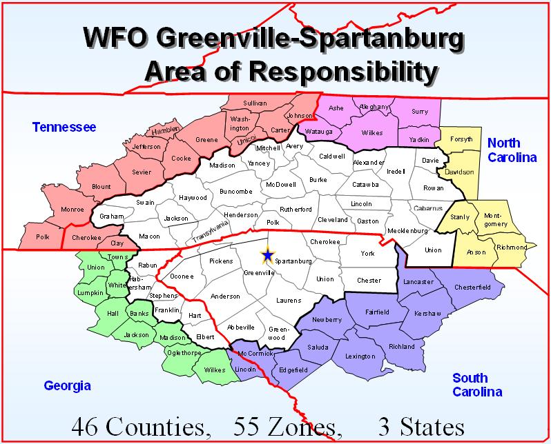
2 Western North Carolina Severe Weather Climatology Tony Sturey
3


4 KNOW YOUR RISK Of the estimated 100,000 thunderstorms that occur each year in the United States, about 10 percent are classified as severe. This map depicts the average number of days with thunderstorms each year. Florida has more days with thunderstorms than any other state. FACT: All thunderstorms are dangerous due to lightning and strong winds.


5 KNOW YOUR RISK Lightning kills an average of 30 to 50 people each year in the U.S. and injures several hundred more. FACT: More than 80% of lightning fatality victims are male, typically between the ages of 15 and 40. FACT: If you are outdoors and can hear thunder, you are in danger of being struck by lightning.


6 KNOW YOUR RISK A tornado is a violently rotating column of air extending from a cumuliform cloud, such as a thunderstorm, to the ground. Joshua Jans FACT: Tornadoes can move in any direction and can travel at speeds up to 70 mph. Roger Edwards This map shows the average number of tornadoes per year in each state. 6
7
8 Topography of Forecast Area 6,684 FT 350 FT
9 GSP County Warning Area Facts Highest = 6,684 feet - Mt. Mitchell, NC Lowest = 270 feet - Chester County, SC Difference = 6,414 feet High 8 COUNTIES WITH TOTAL OF 55 PEAKS > 6,000 FT. Low
 133 inches - Lake Toxaway, NC 130 inches -")
 Transylvania County French Broad River Upper Whitewater Falls")
10 GSP County Warning Area Facts Annual Station Rainfall (Highest East of the Rockies) 133 inches - Lake Toxaway, NC 130 inches - Rosman, NC (More than 10 feet of rain in one year!) Transylvania County French Broad River Upper Whitewater Falls Looking Glass Rock
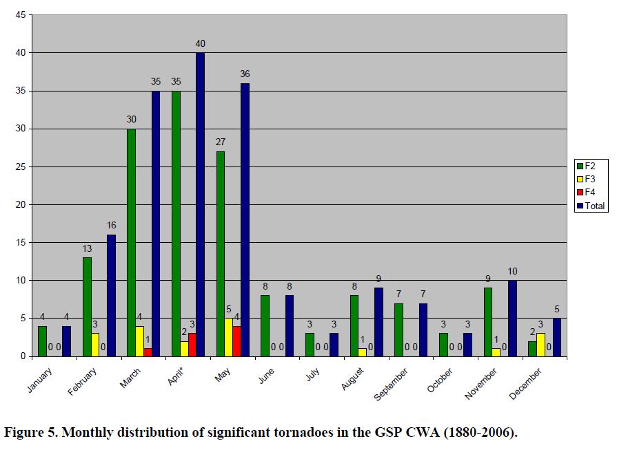
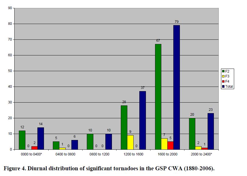
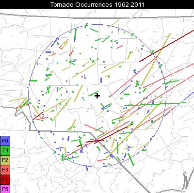
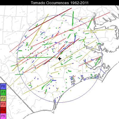
11 Average number of days during a 10-year period with a tornado within ~25 mi of any point. Based upon a 58-year climatology. <
12
13
14 Average number of days per year with a damaging convective wind gust within ~25 mi of any point. Based upon a 25-year climatology
15 Average number of May days per decade with a damaging convective wind gust within ~25 mi of any point
16 Average number of July days per decade with a damaging convective wind gust within ~25 mi of any point

17 Total Number of Days of Damaging Thunderstorm Winds Within a 15 Mile Radius

18 Total Number of Days of Damaging Thunderstorm Winds Within a 15 Mile Radius
19 Average days per year with large hail within ~25 mi of any point. Based upon a 25-year climatology
20 Myth Number 1 No Tornadoes in the Cold Season

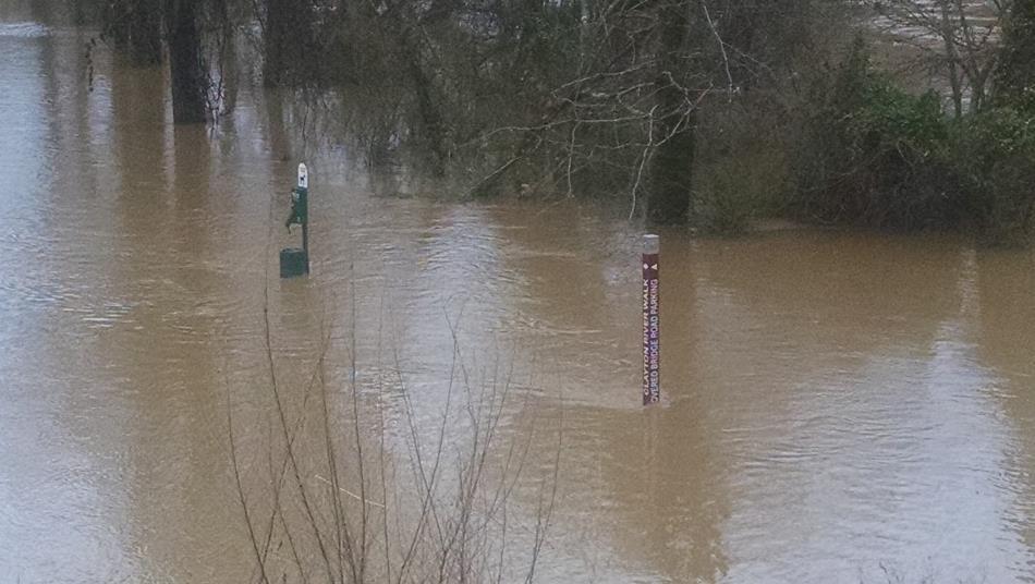
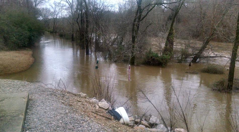
21 Burke County January 2012
22 Myth Number 2 No Tornadoes in the Mountains

23 Great Smoky National Park, 2013 Late Spring, Early Summer
24 Myth Number 3 No Tornadoes in Urban Areas Overnight

25 Charlotte NC, March 3, 2012 Wee Hours

26 Myth Number 4 No Tornadoes: Except When All Personnel are in Their Place of Establishment

27 Vale Area, October 2010
28 The End NOAA NWS Greenville-Spartanburg, SC Tony Sturey Warning and Coordination Meteorologist
29 North Carolina Spring and Summer Outlooks Nick Petro

30 Climate.gov Outlook for the Nation


31 CPC Temp and Precip Outlooks for April, May, and June Equal changes for above, near, or below normal temperatures across North Carolina. Odds favor the chance for above normal precip across North Carolina.


32 Spring flood and drought outlooks Minor river flooding is possible from the Gulf Coast through the Ohio River Valley and into the Southeast from Texas eastward and up the coast to Virginia. Though, heavy rainfall at any time can lead to flooding, even in areas where overall risk is considered low.


33 Past 90 day rain and latest drought monitor
34
35 What about severe thunderstorms and tornadoes?


36 Thunderstorm Ingredients All thunderstorms require 3 ingredients for their formation: 1. Moisture the foundation for clouds and precip. 2. Lifting mechanism initiates the upward movement. 3. Instability keeps the upward movement going. Page 36

37 A 4 th Ingredient for strong to severe storms: Wind Shear Weak shear vs. Strong shear The longer the updraft lives, the stronger the storm can become, and the better the chance for severe t-storm impacts. Page 37
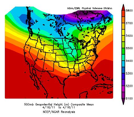

38 April 16, 2011


39 Average weather pattern from Feb 1 thru March 15, 2015 Cold air Dry stable air coming off the Rockies spread eastward Gulf moisture shunted eastward
40
41
42
43
44

45 Will the pattern change?
46 Looking farther down the road using climatology
47 Recent changes to the Storm Prediction Center Convective Outlooks Phil Hysell

48 SPC Outlook Changes October 2014
49


50 SPC Outlooks Before 10/ Tiers - SLGT, MDT and HIGH See Text Used for Marginal Situations
51
52
53
54 Day 1-3 Outlook Changes Increase risk categories to 5 levels for Day 1, Day 2, & Day 3 Outlooks Category 1 = MRGL Category 2 = SLGT Category 3 = ENH Category 4 = MDT Category 5 = HIGH SPC Severe Weather Outlook Probability-to-Categorical Description Tables (2014) Day1 0% 2% 5% 10% 10% sig 15% 15% sig 30% 30% sig 45% 45% sig 60% 60% sig Tor TSTMS MARGINAL SLGT ENHANCED MDT HIGH Wind TSTMS MARGINAL SLGT ENHANCED MDT HIGH Hail TSTMS MARGINAL SLGT ENHANCED MDT Day2 0% 5% 15% 15% sig 30% 30% sig 45% 45% sig 60% 60% sig All Svr TSTMS MARGINAL SLGT ENHANCED MDT HIGH Day3 0% 5% 15% 15% sig 30% 30% sig 45% 45% sig All Svr Day4-8 TSTMS 15% MARGINAL 30% SLGT ENHANCED MDT All Svr SLGT ENHANCED sig = Significant Severe Tstms = Hail 2+ and/or Wind 65KT/75 MPH Tor= EF2 or Stronger
55 Day 1-3 Outlook Changes Increase risk categories to 5 levels for Day 1, Day 2, & Day 3 Outlooks Replace See Text with Marginal for lowest risk probabilities (Day 1 - Day 3) SPC Severe Weather Outlook Probability-to-Categorical Description Tables (2014) Day1 0% 2% 5% 10% 10% sig 15% 15% sig 30% 30% sig 45% 45% sig 60% 60% sig Tor TSTMS MARGINAL SLGT ENHANCED MDT HIGH Wind TSTMS MARGINAL SLGT ENHANCED MDT HIGH Hail TSTMS MARGINAL SLGT ENHANCED MDT Day2 0% 5% 15% 15% sig 30% 30% sig 45% 45% sig 60% 60% sig All Svr TSTMS MARGINAL SLGT ENHANCED MDT HIGH Day3 0% 5% 15% 15% sig 30% 30% sig 45% 45% sig All Svr Day4-8 TSTMS 15% MARGINAL 30% SLGT ENHANCED MDT All Svr SLGT ENHANCED sig = Significant Severe Tstms = Hail 2+ and/or Wind 65KT/75 MPH Tor = EF2 or Stronger
56 Day 1-3 Outlook Changes Increase risk categories to 5 levels for Day 1, Day 2, & Day 3 Outlooks Replace See Text with Marginal for lowest risk probabilities (Day 1 - Day 3) Insert Enhanced between high-end SLGT & low-end MDT probabilities SPC Severe Weather Outlook Probability-to-Categorical Description Tables (2014) Day1 0% 2% 5% 10% 10% sig 15% 15% sig 30% 30% sig 45% 45% sig 60% 60% sig Tor TSTMS MARGINAL SLGT ENHANCED MDT HIGH Wind TSTMS MARGINAL SLGT ENHANCED MDT HIGH Hail TSTMS MARGINAL SLGT ENHANCED MDT Day2 0% 5% 15% 15% sig 30% 30% sig 45% 45% sig 60% 60% sig All Svr TSTMS MARGINAL SLGT ENHANCED MDT HIGH Day3 0% 5% 15% 15% sig 30% 30% sig 45% 45% sig All Svr Day4-8 TSTMS 15% MARGINAL 30% SLGT ENHANCED MDT All Svr SLGT ENHANCED sig = Significant Severe Tstms = Hail 2+ and/or Wind 65KT/75 MPH Tor = EF2 or stronger

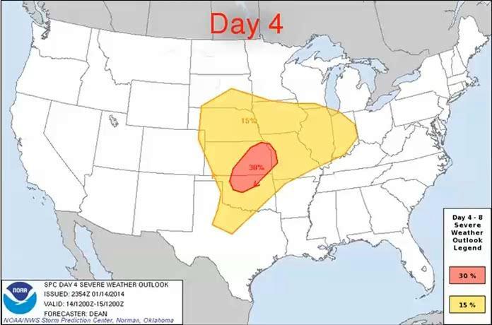
57 Example of Change
58
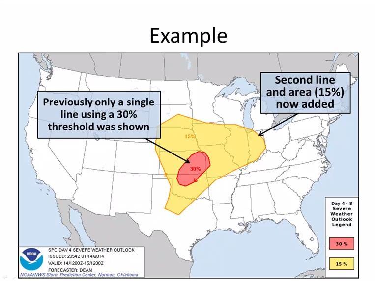
59
60 Day 4-8 Outlook Changes Increase risk categories to 5 levels for Day 1, Day 2, & Day 3 Outlooks Replace See Text with Marginal for lowest risk probabilities (Day 1 - Day 3) Insert Enhanced between high-end Slight & low-end Moderate probabilities Add a 15 percent (Slight Risk) to Day 4-8 Outlooks SPC Severe Weather Outlook Probability-to-Categorical Description Tables (2014) Day1 0% 2% 5% 10% 10% sig 15% 15% sig 30% 30% sig 45% 45% sig 60% 60% sig Tor TSTMS MARGINAL SLGT ENHANCED MDT HIGH Wind TSTMS MARGINAL SLGT ENHANCED MDT HIGH Hail TSTMS MARGINAL SLGT ENHANCED MDT Day2 0% 5% 15% 15% sig 30% 30% sig 45% 45% sig 60% 60% sig All Svr TSTMS MARGINAL SLGT ENHANCED MDT HIGH Day3 0% 5% 15% 15% sig 30% 30% sig 45% 45% sig All Svr TSTMS MARGINAL SLGT ENHANCED MDT Day4-8 15% 30% All Svr SLGT ENHANCED Expected to result in better alignment with WFO forecasts and DSS
61
62 Thank You! Tony Sturey, WCM NWS Greenville/Spartanburg, SC Nick Petro, WCM NWS Raleigh, NC Phil Hysell, WCM NWS Blacksburg, VA
We Had No Warning An Overview of Available Forecast Products Before and During Severe Weather Events
 We Had No Warning An Overview of Available Forecast Products Before and During Severe Weather Events Two main sources for severe weather info NOAA/NWS Storm Prediction Center (SPC) Convective Outlooks
National Weather Service Greenville-Spartanburg, Forecast Office
 National Weather Service Greenville-Spartanburg, Forecast Office CoCoRaHS Presentation: NC CERT Conference May, 2017 Introduction- who we are. Federal Agency Within the U.S. Dept. of Commerce Introduction-
California OES Weather Threat Briefing
 California OES Weather Threat Briefing Wednesday, January 16, 2019 9:00 AM PST Day 1: Strong winds, heavy mountain snow and heavy rain with isolated thunderstorms across much of the state through Thursday
4/18/2010. National Weather Service. Severe Weather Forecasting: A Western North Carolina Case Study
 National Weather Service Severe Weather Forecasting: A Western North Carolina Case Study Laurence G. Lee Science and Operations Officer National Weather Service Greer, SC Plus 13 River Forecast Centers
SPC Mission Statement. Tornado in Miami, FL Photo: Miami Herald. What is SPC s Responsibility? More SPC Products. SPC Products
 The NOAA/NWS Storm Prediction Center Adapted from a presentation to UNCA atmospheric science students by David Imy SPC Mission Statement SPC exists to protect life and property of the American people through
El Niño Update Impacts on Florida
 Current Issues in Emergency Management (CIEM) Sessions 1 &2 October 12 th and 26 th, 2006 Florida Division of Emergency Management Tallahassee, Florida El Niño Update Impacts on Florida Bart Hagemeyer
Foundations of Earth Science, 6e Lutgens, Tarbuck, & Tasa
 Foundations of Earth Science, 6e Lutgens, Tarbuck, & Tasa Weather Patterns and Severe Weather Foundations, 6e - Chapter 14 Stan Hatfield Southwestern Illinois College Air masses Characteristics Large body
Severe Thunderstorm Forecasting and Climatology in Arizona. Ken Drozd Warning Coordination Meteorologist NOAA/NWS Tucson, AZ
 Severe Thunderstorm Forecasting and Climatology in Arizona Ken Drozd Warning Coordination Meteorologist NOAA/NWS Tucson, AZ THUNDERSTORM FORMATION All thunderstorms result from the same necessary conditions
Chapter 3: Weather Fronts & Storms
 Chapter 3: Weather Fronts & Storms An AIR MASS is a large body of air that has similar characteristics (temperature, humidity) throughout. Air masses can be massively large. Air masses are classified by
Your Task: Read each slide then use the underlined red or underlined information to fill in your organizer.
 Severe Weather: Tornadoes and Hurricanes Thunderstorms and Lightning S6E4 d. Construct an explanation of the relationship between air pressure, weather fronts, and air masses and meteorological events
Monthly Long Range Weather Commentary Issued: APRIL 18, 2017 Steven A. Root, CCM, Chief Analytics Officer, Sr. VP,
 Monthly Long Range Weather Commentary Issued: APRIL 18, 2017 Steven A. Root, CCM, Chief Analytics Officer, Sr. VP, sroot@weatherbank.com MARCH 2017 Climate Highlights The Month in Review The average contiguous
HAZARDOUS WEATHER 1. Dr. Julie Laity Geography 266
 HAZARDOUS WEATHER 1 Dr. Julie Laity Geography 266 Violent Weather Thunderstorms Atmospheric turbulence Lightning and thunder Hail Derechos Tornadoes Tornado measurement and science Tropical Cyclones Hurricanes
THUNDERSTORMS Brett Ewing October, 2003
 THUNDERSTORMS Brett Ewing October, 2003 A natural hazard that occurs often on a daily basis in the lower and mid-latitudes is thunderstorms. Thunderstorms is a weather system that can produce lightning,tornadoes,
The Weather Wire. Contents: Summer 2018 Outlook. Summer 2018 Outlook Drought Monitor May Summary/Statistics June Preview Rainfall Totals
 The Weather Wire June 2018 Volume 25 Number 6 Contents: Summer 2018 Outlook Drought Monitor May Summary/Statistics June Preview Rainfall Totals Summer 2018 Outlook June 1 st marked the first day of meteorological
Module 11: Meteorology Topic 6 Content: Severe Weather Notes
 Severe weather can pose a risk to you and your property. Meteorologists monitor extreme weather to inform the public about dangerous atmospheric conditions. Thunderstorms, hurricanes, and tornadoes are
Monthly Long Range Weather Commentary Issued: May 15, 2014 Steven A. Root, CCM, President/CEO
 Monthly Long Range Weather Commentary Issued: May 15, 2014 Steven A. Root, CCM, President/CEO sroot@weatherbank.com APRIL 2014 REVIEW Climate Highlights The Month in Review The average temperature for
Severe Weather with a strong cold front: 2-3 April 2006 By Richard H. Grumm National Weather Service Office State College, PA 16803
 Severe Weather with a strong cold front: 2-3 April 2006 By Richard H. Grumm National Weather Service Office State College, PA 16803 1. INTRODUCTION A strong cold front brought severe weather to much of
TROPICAL STORM NATE BRIEFING
 TROPICAL STORM NATE BRIEFING 10:30 AM CDT Friday, October 06, 2017 Prepared by: NWS NWSNewOrleans www.weather.gov/neworleans Situation Overview Track forecast has shifted slightly eastward. Hurricane Watch
Weather and Climate Summary and Forecast Winter
 Weather and Climate Summary and Forecast Winter 2016-17 Gregory V. Jones Southern Oregon University February 7, 2017 What a difference from last year at this time. Temperatures in January and February
The Wind Hazard: Messaging the Wind Threat & Corresponding Potential Impacts
 The Wind Hazard: Messaging the Wind Threat & Corresponding Potential Impacts Scott Spratt Warning Coordination Meteorologist NWS Melbourne, FL David Sharp Science & Operations Officer NWS Melbourne, FL
TROPICAL STORM NATE BRIEFING
 TROPICAL STORM NATE BRIEFING 2:00 PM CDT Friday, October 06, 2017 Prepared by: NWS NWSNewOrleans www.weather.gov/neworleans Situation Overview Track forecast has not changed since the 10 am advisory. Hurricane
Weather and Climate Summary and Forecast February 2018 Report
 Weather and Climate Summary and Forecast February 2018 Report Gregory V. Jones Linfield College February 5, 2018 Summary: For the majority of the month of January the persistent ridge of high pressure
Chapter 14 Thunderstorm Fundamentals
 Chapter overview: Thunderstorm appearance Thunderstorm cells and evolution Thunderstorm types and organization o Single cell thunderstorms o Multicell thunderstorms o Orographic thunderstorms o Severe
TROPICAL CYCLONE TORNADOES
 TROPICAL CYCLONE TORNADOES 2018 GOVERNOR S HURRICANE CONFERENCE TUESDAY, MAY 15, 2018 WILL ULRICH NWS FORECAST OFFICE MELBOURNE WHERE ARE THE TORNADOES? WHERE ARE THE TORNADOES? C B A WEST MELBOURNE, FL
National Situation Report As of 5:00 a.m. EDT Tuesday, April 4, 2017
 Overview National Situation Report As of 5:00 a.m. EDT Tuesday, April 4, 2017 Table Of Contents Current Operations Monitoring Recovery National Response Coordination Center: Not Activated National Watch
Severe Weather: Tornadoes and Hurricanes
 Severe Weather: Tornadoes and Hurricanes Tornadoes Grab Toto!! TORNADOES Are a low pressure storm that usually forms over land in an average year, 800 tornadoes are reported in the U.S. a tornado is defined
Weather and Climate Summary and Forecast Summer 2017
 Weather and Climate Summary and Forecast Summer 2017 Gregory V. Jones Southern Oregon University August 4, 2017 July largely held true to forecast, although it ended with the start of one of the most extreme
Issued by: National Weather Service San Joaquin Valley - Hanford CA. Issue time: 409 AM PST Wed Jan
 Forecast Information Location: New_Exchequer_Dam Updated: January 16, 2019, 11:45 am NWS Weather Discussion: Issued by: National Weather Service San Joaquin Valley - Hanford CA Issue time: 409 AM PST Wed
20.1 Air Masses. Weather Patterns and Severe Storms. Four Types of Source Regions. Weather in North America Fronts
 20.1 Air Masses Weather Patterns and Severe Storms Chapter 20 A huge body of air that has a uniform temperature and humidity. They move slowly, and take on the properties of their source regions. Four
SEPTEMBER 2013 REVIEW
 Monthly Long Range Weather Commentary Issued: October 21, 2013 Steven A. Root, CCM, President/CEO sroot@weatherbank.com SEPTEMBER 2013 REVIEW Climate Highlights The Month in Review The average temperature
Kentucky Weather Hazards: What is Your Risk?
 Kentucky Weather Hazards: What is Your Risk? Stuart A. Foster State Climatologist for Kentucky 2010 Kentucky Weather Conference Bowling Green, Kentucky January 16, 2010 Perspectives on Kentucky s Climate
Unit 4. This unit will enable you to improve coordination and communication with State and local agencies when hazardous weather threatens.
 Unit 4 This unit will enable you to improve coordination and communication with State and local agencies when hazardous weather threatens. In this unit we will discuss the role of Emergency Managers in
Oregon Water Conditions Report April 17, 2017
 Oregon Water Conditions Report April 17, 2017 Mountain snowpack continues to maintain significant levels for mid-april. By late March, statewide snowpack had declined to 118 percent of normal after starting
LECTURE #15: Thunderstorms & Lightning Hazards
 GEOL 0820 Ramsey Natural Disasters Spring, 2018 LECTURE #15: Thunderstorms & Lightning Hazards Date: 1 March 2018 (lecturer: Dr. Shawn Wright) I. Severe Weather Hazards focus for next few weeks o somewhat
Monthly Long Range Weather Commentary Issued: SEPTEMBER 19, 2016 Steven A. Root, CCM, Chief Analytics Officer, Sr. VP,
 Monthly Long Range Weather Commentary Issued: SEPTEMBER 19, 2016 Steven A. Root, CCM, Chief Analytics Officer, Sr. VP, sroot@weatherbank.com SEPTEMBER 2016 Climate Highlights The Month in Review The contiguous
Champaign-Urbana 1998 Annual Weather Summary
 Champaign-Urbana 1998 Annual Weather Summary ILLINOIS STATE WATER SURVEY Audrey Bryan, Weather Observer 2204 Griffith Dr. Champaign, IL 61820 wxobsrvr@sparc.sws.uiuc.edu The development of the El Nìno
III. Section 3.3 Vertical air motion can cause severe storms
 III. Section 3.3 Vertical air motion can cause severe storms http://www.youtube.com/watch?v=nxwbr60tflg&feature=relmfu A. Thunderstorms form from rising moist air Electrical charges build up near the tops
TORNADOES. DISPLAY VISUAL A Tornado Is... Tornadoes can: Rip trees apart. Destroy buildings. Uproot structures and objects.
 TORNADOES Introduce tornadoes by explaining what a tornado is. DISPLAY VISUAL A Tornado Is... A powerful, circular windstorm that may be accompanied by winds in excess of 250 miles per hour. Tell the participants
Thunderstorms. Thunderstorm Recipe
 Thunderstorms A thunderstorm is a storm with lightning and thunder. It's produced by a cumulonimbus cloud, usually producing gusty winds, heavy rain and sometimes hail. A typical thunderstorm is 15 miles
Weather and Climate Summary and Forecast March 2018 Report
 Weather and Climate Summary and Forecast March 2018 Report Gregory V. Jones Linfield College March 7, 2018 Summary: The ridge pattern that brought drier and warmer conditions from December through most
Comparison of November 15, 2008 Killer Tornado Outbreak with the December 2, 2009 Non Tornado Event
 Comparison of November 15, 2008 Killer Tornado Outbreak with the December 2, 2009 Non Tornado Event The two events featured similar patterns but with much different results in central NC. The slides on
SIGNIFICANT EVENTS Severe Storms November 1994 January 1996 August 1998 and May 2000 March 2002 May 2002 Champaign County
 SIGNIFICANT EVENTS Severe Storms November 1994 On Nov. 1, 1994, high winds gusted over 60 mph at times across the northwest third of Ohio. The highest measured wind gust was 63 mph at Columbus Grove (Putnam).
Severe Weather Watches, Advisories & Warnings
 Severe Weather Watches, Advisories & Warnings Tornado Watch Issued by the Storm Prediction Center when conditions are favorable for the development of severe thunderstorms and tornadoes over a larger-scale
COMMUNITY EMERGENCY RESPONSE TEAM TORNADOES
 Tornadoes are powerful, circular windstorms that may be accompanied by winds in excess of 200 miles per hour. Tornadoes typically develop during severe thunderstorms and may range in width from several
Extreme Rainfall in the Southeast U.S.
 Extreme Rainfall in the Southeast U.S. David F. Zierden Florida State Climatologist Center for Ocean Atmospheric Prediction Studies The Florida State University March 7, 2016 Causes of Extreme Rainfall
Weather and Climate Summary and Forecast March 2019 Report
 Weather and Climate Summary and Forecast March 2019 Report Gregory V. Jones Linfield College March 2, 2019 Summary: Dramatic flip from a mild winter to a top five coldest February on record in many locations
The Earth System - Atmosphere III Convection
 The Earth System - Atmosphere III Convection Thunderstorms 1. A thunderstorm is a storm that produces lightning (and therefore thunder) 2. Thunderstorms frequently produce gusty winds, heavy rain, and
TOPICS: What are Thunderstorms? Ingredients Stages Types Lightning Downburst and Microburst
 THUNDERSTORMS TOPICS: What are Thunderstorms? Ingredients Stages Types Lightning Downburst and Microburst What are Thunderstorms? A storm produced by a cumulonimbus cloud that contains lightning and thunder
MIAMI-SOUTH FLORIDA National Weather Service Forecast Office
 MIAMI-SOUTH FLORIDA National Weather Service Forecast Office http://www.weather.gov/miami June 2015 South Florida Weather Summary Dry East, Wet West...Drought Remains SE Florida July 3, 2015: Depending
Daily Operations Briefing Tuesday, April 4, :30 a.m. EDT
 Daily Operations Briefing Tuesday, April 4, 2017 8:30 a.m. EDT Significant Activity Apr 3-4 Significant Events: Severe Weather Southern Plains to Southeast Significant Weather: Severe Thunderstorms and
Severe Weather Potential for Southeast Texas
 Severe Weather Potential for Southeast Texas Dan Reilly, Kent Prochazka, Scott Overpeck National Weather Service Houston/Galveston 10 am Synopsis Storm to likely bring severe weather to Southeast Texas
Tornadoes pose a high risk because the low atmospheric pressure, combined with high wind velocity, can:
 Tornadoes are powerful, circular windstorms that may be accompanied by winds in excess of 200 miles per hour. Tornadoes typically develop during severe thunderstorms and may range in width from several
HURRICANE NATE BRIEFING
 HURRICANE NATE BRIEFING 2:00 PM CDT Saturday, October 07, 2017 Prepared by: NWS NWSNewOrleans www.weather.gov/neworleans Situation Overview continues to intensify. It is now forecast to be a category 2
2/27/2015. Big questions. What can we say about causes? Bottom line. Severe Thunderstorms, Tornadoes, and Climate Change: What We Do and Don t Know
 Severe Thunderstorms, Tornadoes, and Climate Change: What We Do and Don t Know Big questions How and why are weather hazards distributed? Are things changing in time and will they? HAROLD BROOKS NOAA/NSSL
ATS 351, Spring 2010 Lab #11 Severe Weather 54 points
 ATS 351, Spring 2010 Lab #11 Severe Weather 54 points Question 1 (10 points): Thunderstorm development a) Sketch and describe the stages of development of a single cell thunderstorm. About how long does
& Locations. Dr. Kim D. Coder, Professor of Tree Biology & Health Care, Warnell School, UGA
 Storm & Lightning Ground Strike Numbers & Locations Dr. Kim D. Coder, Professor of Tree Biology & Health Care, Warnell School, UGA Lightning formation requires large energy transformations. These lightning
Table 1. August average temperatures and departures from normal ( F) for selected cities.
 for selected cities.") Climate Summary for Florida August 2016 Prepared by Lydia Stefanova and David Zierden Florida Climate Center, The Florida State University, Tallahassee, Florida Online at: http://climatecenter.fsu.edu/products-services/summaries
Climate Summary for Florida August 2016 Prepared by Lydia Stefanova and David Zierden Florida Climate Center, The Florida State University, Tallahassee, Florida Online at: http://climatecenter.fsu.edu/products-services/summaries
Weather Patterns and Severe Storms
 Weather Patterns and Severe Storms 20.1 Air Masses Air Masses and Weather Air Masses An air mass is an immense body of air that is characterized by similar temperatures and amounts of moisture at any given
Monthly Long Range Weather Commentary Issued: July 18, 2014 Steven A. Root, CCM, President/CEO
 Monthly Long Range Weather Commentary Issued: July 18, 2014 Steven A. Root, CCM, President/CEO sroot@weatherbank.com JUNE 2014 REVIEW Climate Highlights The Month in Review The average temperature for
Major Hurricane Earl
 Major Hurricane Earl Advisory 32 North Carolina Threat Assessment Prepared at: 8 AM Thursday September 2, 2010 Hurricane and Tropical Storm Warnings in effect for the North Carolina Coast and Sounds. NWS
2011 Year in Review TORNADOES
 2011 Year in Review The year 2011 had weather events that will be remembered for a long time. Two significant tornado outbreaks in April, widespread damage and power outages from Hurricane Irene in August
Monthly Long Range Weather Commentary Issued: NOVEMBER 16, 2015 Steven A. Root, CCM, Chief Analytics Officer, Sr. VP, sales
 Monthly Long Range Weather Commentary Issued: NOVEMBER 16, 2015 Steven A. Root, CCM, Chief Analytics Officer, Sr. VP, sales sroot@weatherbank.com OCTOBER 2015 Climate Highlights The Month in Review The
The National Oceanic and Atmospheric Administration (NOAA) National Weather Service (NWS) Severe Thunderstorm Observing and Radar Monitoring
 National Weather Service (NWS) Severe Thunderstorm Observing and Radar Monitoring") The National Oceanic and Atmospheric Administration (NOAA) Presents National Weather Service (NWS) Severe Thunderstorm Observing and Radar Monitoring Severe Weather Spotter Line 1-888-668-3344 Spotter
The National Oceanic and Atmospheric Administration (NOAA) Presents National Weather Service (NWS) Severe Thunderstorm Observing and Radar Monitoring Severe Weather Spotter Line 1-888-668-3344 Spotter
NWS HURRICANES June 3, 2015
 NWS HURRICANES June 3, 2015 Hurricane Season June 1 November 30 2 What s the concern? All tropical systems passing within 125nm of central Maryland since 1950 Mid-Atlantic Hurricanes Greatest Risk: August
Weather and Climate Summary and Forecast April 2018 Report
 Weather and Climate Summary and Forecast April 2018 Report Gregory V. Jones Linfield College April 4, 2018 Summary: A near Miracle March played out bringing cooler and wetter conditions to the majority
The Pennsylvania Observer
 The Pennsylvania Observer April 2, 2009 March 2009 Pennsylvania Weather Recap Prepared by Curt Harpster For the month of March the saying, In like a lion and out like a lamb really fit the pattern quite
How strong does wind have to be to topple a garbage can?
 How strong does wind have to be to topple a garbage can? Imagine winds powerful enough to pick up a truck and toss it the length of a football field. Winds of this extreme sometimes happen in a tornado.
Weather and Climate Summary and Forecast August 2018 Report
 Weather and Climate Summary and Forecast August 2018 Report Gregory V. Jones Linfield College August 5, 2018 Summary: July 2018 will likely go down as one of the top five warmest July s on record for many
Mid Atlantic Severe Event of 1 May 2017 Central Pennsylvania QLCS event By Richard H. Grumm National Weather Service, State College, PA 16803
 1. Overview Mid Atlantic Severe Event of 1 May 2017 Central Pennsylvania QLCS event By Richard H. Grumm National Weather Service, State College, PA 16803 A strong upper-level wave (Fig.1) moving into a
Flooding in Western North Carolina: Some Spatial, Hydrologic, and Seasonal Characteristics CAUTION!! Outline. Basic Flood Facts.
 Flooding in Western North Carolina: Some Spatial, Hydrologic, and Seasonal Characteristics J. Greg Dobson CAUTION!! National Environmental Modeling and Analysis Center RENCI at UNC-Asheville Engagement
Unit 5 Part 2 Test PPT
 Unit 5 Part 2 Test PPT Standard 1: Air Masses Air Mass An air mass is an immense body of air that is characterized by similar temperatures and amounts of moisture at any given altitude When an air mass
TROPICAL STORM HARVEY BRIEFING
 TROPICAL STORM HARVEY BRIEFING 2:00 PM CDT Tuesday, August 29, 2017 Prepared by: NWS LIX NWSNewOrleans www.weather.gov/neworleans Situation Overview New Information Moving NNE Max sustained wind 45 mph
Tornadoes. Tornadoes COMMUNITY EMERGENCY RESPONSE TEAM TORNADOES
 Tornadoes Tornadoes Tell the participants that tornadoes are powerful, circular windstorms that may be accompanied by winds in excess of 200 miles per hour. Tornadoes typically develop during severe thunderstorms
Tropical Storm Ana. Created 6:00 AM Sun May 10, 2015 John Cole Warning Coordination Meteorologist
 Tropical Storm Ana Threat Assessment for Eastern North Carolina Created 6:00 AM Sun May 10, 2015 John Cole Warning Coordination Meteorologist John.cole@noaa.gov National Weather Service Newport/Morehead
Climate. Annual Temperature (Last 30 Years) January Temperature. July Temperature. Average Precipitation (Last 30 Years)
 January Temperature. July Temperature. Average Precipitation (Last 30 Years)") Climate Annual Temperature (Last 30 Years) Average Annual High Temp. (F)70, (C)21 Average Annual Low Temp. (F)43, (C)6 January Temperature Average January High Temp. (F)48, (C)9 Average January Low Temp.
Climate Annual Temperature (Last 30 Years) Average Annual High Temp. (F)70, (C)21 Average Annual Low Temp. (F)43, (C)6 January Temperature Average January High Temp. (F)48, (C)9 Average January Low Temp.
The Climate of Payne County
 The Climate of Payne County Payne County is part of the Central Great Plains in the west, encompassing some of the best agricultural land in Oklahoma. Payne County is also part of the Crosstimbers in the
Chapter 21. Weather Patterns and Severe Storms
 Chapter 21 Weather Patterns and Severe Storms 20.1 Air Masses Air Masses and Weather Air Masses An air mass is an immense body of air that is characterized by similar temperatures and amounts of moisture
MET Lecture 29 Tornadoes IV
 MET 4300 Lecture 29 Tornadoes IV Outline Definition, life cycle, & climatology of tornadoes Tornado formation within supercells Tornado formation within nonsupercell thunderstorms Fujita scale Tornado
Case Study: Severe Thunderstorm Over Fairbanks, AK on 8 th of June, 1997
 Case Study: Severe Thunderstorm Over Fairbanks, AK on 8 th of June, 1997 Michael Richmond NWS - WFO Fairbanks 23 August, 2007 Introduction: Thunderstorms are a prominent feature of the Alaska Interior
Weather and Climate Summary and Forecast Fall/Winter 2016
 Weather and Climate Summary and Forecast Fall/Winter 2016 Gregory V. Jones Southern Oregon University November 5, 2016 After a year where we were seemingly off by a month in terms of temperatures (March
Major Hurricane Earl
 Major Hurricane Earl Advisory 33 North Carolina Threat Assessment Prepared at: 11 AM Thursday September 2, 2010 Hurricane and Tropical Storm Warnings in effect for the North Carolina Coast and Sounds NWS
Tropical Storm Ana. Created 615 AM Sat May 9, 2015 Reid Hawkins, Science Officer
 Tropical Storm Ana Threat Assessment for northeast South Carolina & southeast North Carolina Created 615 AM Sat May 9, 2015 Reid Hawkins, Science Officer National Weather Service Wilmington, NC 1 New Information
Heavy Rain and Potential for Dangerous Flooding for northeast SC and southeast NC
 US National Weather Service Wilmington NC @NWSWilmingtonNC http://weather.gov/ilm ***Life Threatening Flooding Possible*** Heavy Rain and Potential for Dangerous Flooding for northeast SC and southeast
CHAPTER 11 THUNDERSTORMS AND TORNADOES MULTIPLE CHOICE QUESTIONS
 CHAPTER 11 THUNDERSTORMS AND TORNADOES MULTIPLE CHOICE QUESTIONS 1. A thunderstorm is considered to be a weather system. a. synoptic-scale b. micro-scale c. meso-scale 2. By convention, the mature stage
Weather and Climate Summary and Forecast November 2017 Report
 Weather and Climate Summary and Forecast November 2017 Report Gregory V. Jones Linfield College November 7, 2017 Summary: October was relatively cool and wet north, while warm and very dry south. Dry conditions
Advanced Spotter Training: Anticipating Severe Weather Threats. Professor Paul Sirvatka College of DuPage Meteorology
 Advanced Spotter Training: Anticipating Severe Weather Threats College of DuPage Meteorology Preparing for Severe Weather Preparedness involves understanding the probable and potential threats. Understanding
Unit 4 Review Guide: Weather
 Unit 4 Review Guide: Weather Weather: The condition of the atmosphere at a specific time and place. Freezing: To become hardened into ice or into a solid body Deposition: The change in state of matter
The Pennsylvania Observer
 The Pennsylvania Observer October 1, 2015 September 2015 - Pennsylvania Weather Recap By: Quinn Lease The month of September will be remembered for its above normal temperatures and dry conditions that
A bright flash that is produced due to electrical discharge and occurs during a thunderstorm.
 Science Mr. G/Mrs. Kelly Name: KEY Date: Inv.6.1 - That s a Fact: An Introduction to Thunderstorms, Tornadoes, and Hurricanes (pgs.92-97) 1. Define lightning. A bright flash that is produced due to electrical
Severe Weather. Copyright 2006 InstructorWeb
 Severe Weather People need to know what the weather is going to do. Sometimes severe weather can happen. Severe weather can cause property damage, injuries to people and animals, and even loss of life.
P4.479 A DETAILED ANALYSIS OF SPC HIGH RISK OUTLOOKS,
 P4.479 A DETAILED ANALYSIS OF SPC HIGH RISK OUTLOOKS, 2003-2009 Jason M. Davis*, Andrew R. Dean 2, and Jared L. Guyer 2 Valparaiso University, Valparaiso, IN 2 NOAA/NWS Storm Prediction Center, Norman,
Mark Thornton LakeErieWX: Marine Weather Education and Forecasting Resources
 Mark Thornton LakeErieWX: Marine Weather Education and Forecasting Resources Thunderstorm Hazards It Only Takes One To Ruin Your Outing Lightning Damaging Wind Higher Waves Hail Heavy Precipitation / Reduced
Daily Operations Briefing December 25, 2012 As of 6:30 a.m. EST
 Daily Operations Briefing December 25, 2012 As of 6:30 a.m. EST 1 Significant Activity: Dec 24-25 Significant Events: Possible Severe thunderstorms - Gulf Coast Sandy/Nor easter recovery Significant Weather:
10/21/2012. Chapter 10 Thunderstorms. Part II. Growth and Development of ordinary Cell Thunderstorms Thunderstorm Electrification.
 Chapter 10 Thunderstorms Part I Growth and Development of ordinary Cell Thunderstorms Thunderstorm Electrification Tornadoes Part II Simplified model depicting the life cycle of an ordinary thunderstorm
Tornadoes. tornado: a violently rotating column of air
 Tornadoes tornado: a violently rotating column of air Tornadoes What is the typical size of a tornado? What are typical wind speeds for a tornado? Five-stage life cycle of a tornado Dust Swirl Stage Tornado
The Severe Weather Event of 7 August 2013 By Richard H. Grumm and Bruce Budd National Weather Service State College, PA 1. INTRODUCTION and Overview
 The Severe Weather Event of 7 August 2013 By Richard H. Grumm and Bruce Budd National Weather Service State College, PA 1. INTRODUCTION and Overview A fast moving short-wave (Fig. 1) with -1σ 500 hpa height
DEPARTMENT OF EARTH & CLIMATE SCIENCES SAN FRANCISCO STATE UNIVERSITY. Metr Fall 2014 Test #1 September 30, 2014
 DEPARTMENT OF EARTH & CLIMATE SCIENCES SAN FRANCISCO STATE UNIVERSITY NAME Metr 302.02 Fall 2014 Test #1 September 30, 2014 200 pts (4 pts each answer) Part I. Surface Chart Interpretation. Questions 1
2012 Growing Season Weather Summary for North Dakota. Adnan Akyüz and Barbara A. Mullins Department of Soil Science October 30, 2012
 2012 Growing Season Weather Summary for North Dakota Adnan Akyüz and Barbara A. Mullins Department of Soil Science October 30, 2012 Introduction The 2012 growing season (the period from April through September)
The Climate of Grady County
 The Climate of Grady County Grady County is part of the Central Great Plains, encompassing some of the best agricultural land in Oklahoma. Average annual precipitation ranges from about 33 inches in northern
Agricultural Outlook Forum Presented: February 17, 2006 THE SCIENCE BEHIND THE ATLANTIC HURRICANES AND SEASONAL PREDICTIONS
 Agricultural Outlook Forum Presented: February 17, 2006 THE SCIENCE BEHIND THE ATLANTIC HURRICANES AND SEASONAL PREDICTIONS Gerald Bell Meteorologist, National Centers for Environmental Prediction NOAA,