Geomorphological features and Classification (Classification of landforms):
|
|
|
- Angelina Green
- 5 years ago
- Views:
Transcription

1 Geomorphological features and Classification (Classification of landforms): Landforms are the individual topographic features exposed on the Earth s surface. Landforms vary in size and shape and include features such as small sand dunes, or large features such as the River or Mountains. Landforms develop over a range of different timescales. Some landforms develop rather quickly (over a few seconds, minutes, or hours), such as a landslide, while others may involve many millions of years to form, such as a mountain range. Landform development can be relatively simple and involve only a few processes, or very complex and involve a combination of multiple processes and agents. Landforms are dynamic features that are continually affected by a variety of earth-surface processes including weathering, erosion, and deposition. The landforms are a product of either constructive and destructive processes or a combination of both. Landforms are also influenced by other agents or processes including time, climate, and human activity. Landforms can be classified into following types: 1. Tectonic landforms 2. Extrusive Igneous Landforms 3. Intrusive Igneous Landforms 4. Fluvial Landforms 5. Karst Landforms 6. Aeolian Landforms 7. Coastal Landforms 8. Glacial Landforms 1. Tectonic Landforms: i. Anticlines: Anticlines are defined as folds in which strata are uparched. The older rocks are in interior and younger rocks form outermost bend. The limbs dip away from each other. Symbologically an anticline is indicated by two arrows diverging away from the central point. 1


2 ii. Synclines: Synclines are defined as folds in which strata are downarched. The younger rocks are in interior and older rocks form outermost bend. The limbs dip away from each other. Symbologically an anticline is indicated by two arrows converging towards the central point. iii. Horst and graben: These are elongated fault blocks of the Earth s crust that have been raised and lowered, respectively, relative to their surrounding areas as a direct effect of faulting. Horsts and grabens may range in size from blocks a few centimetres wide to tens of kilometres wide, the vertical movement may be up to several thousand feet. 2


3 2. Volcanic Landforms: Extrusive Igneous: The landforms formed due to cooling and solidification of molten lava at the earth's surface are called extrusive igneous/volcanic landforms. i. Cinder cones: Cinder cones are relatively small cone shaped hills formed by the accumulation of cinders (cinders are walnut and pea sized solid volcanic materials) and ash during volcanic eruptions. Cinder cone ii. iii. iv. v. 3


4 ii. Shield volcanoes: Shield volcanoes are broad shaped mountain landforms built by the accumulation of low viscosity lava that goes to long distances. Their slopes are often very gentle and peaks are relatively flat. They received their name because their gently domed form resembles the exterior of a warrior s shield. iii. Strato volcanoes: Strato volcanoes, also referred to as composite cones, are tall and conical, nearly symmetrical mountainous landforms having steep slopes, formed by a combination of hardened lava flows and intense pyroclastic eruptions (solid eruptions) arranged in layers (strata). 4


5 iv. Caldera: A caldera is a large, usually circular depression at the summit of a volcano formed when magma is withdrawn or erupted from a shallow underground magma reservoir. The removal of large volumes of magma may result in loss of structural support for the overlying rock, thereby leading to collapse of the ground and formation of a large depression. ETM+ image of Deriba Caldera, Sudan 5
 lava that soon cools and hardens into a shell of rock.")
6 v. Lava Domes: Lava domes are basically what the name describes, domes of lava. They are formed through accumulations of thick, highly viscous (thick) lava that soon cools and hardens into a shell of rock. If conditions are right, say more lava rises up or the environment is too dry, the rock shatters and tumbles down the sides. The process repeats itself and after a while the dome builds itself up. 3. Intrusive Igneous Landforms: The landforms formed due to cooling and solidification of magma inside the earth surface is called intrusive igneous/volcanic landforms. i. Dikes: Dikes are small tabular intrusions that are mostly perpendicular to the layers of pre-existing rock. The thickness of dikes ranges from few centimetres to several metres but the length extends from a few metres to several kilometres. ii. iii. iv. Sills: These are also tabular intrusions that are intruded parallel to layers of preexisting rock. The thickness of sills ranges from few centimetres to several metres. Laccoliths: Similar to a sill, except the layers above are bent upward by the intrusion. Batholiths: 6

7 These are large intrusions with irregular shape that cover hundreds or thousands of square kilometers. v. Stocks /Plutons: These are small irregular intrusions. vi. Lopolith: These are mega-sills that may cover hundreds of square kilometers. 4. Fluvial Landforms: Landforms formed due to the action of rivers and streams are known as fluvial landforms. i. Flood plain: A river may overflow its banks during times of heavy rain. When the river recedes, the river deposits the material it is carrying, leaving behind silt. Floodplains are the wide and flat plains formed by the deposited material on either side of the river with successive floods over the years. The heavier and coarser sediments are first deposited at the river s edge. The finer particles are being deposited a little further away from the river. 7


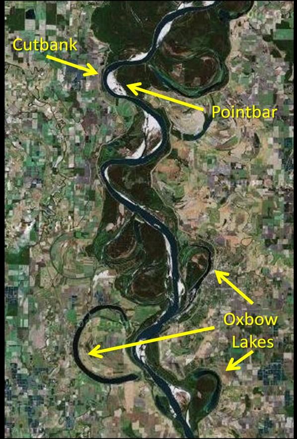
8 Satellite image of Mississippi river flood plain 8

9 ii. Waterfall: Waterfall is a steep descent of water from a height. Waterfalls occur due to changes in bedrock resistance, or along fractures or faults in the bedrock. Less resistant materials are weathered more quickly than resistant rocks, thus creating waterfalls. Faults and fractures often provide natural pathways for the downslope movement of water Ikonos image of Niagara falls, Canada iii. Alluvial fan and Bajada: An alluvial fan is a fan shaped deposit of silt, sand, gravel, and boulders (alluvium) on land where a river emerges from a mountainous area and flows out onto a more gently sloping plain. Alluvial fans generally form in arid environments with a high sediment load and where there is minimal vegetation to disrupt the fan formation. Alluvial fans may form from a single high-flow event or from the accumulation of multiple events. Bajada is a compound alluvial fan formed by the merging or convergence of many alluvial fans (minimum two alluvial fans). 9


10 Alluvial fan Google earth image of bajada near Red sea, Jordan 10


11 5. Karst Landforms: Karst is a term used to describe landscapes that are formed by chemical weathering process controlled by groundwater activity. Karst landscapes are predominantly composed of limestone rock that contains > 70 percent calcium carbonate. i. Caverns: Limestone caverns/caves are large sub-surface voids where the rocks have been dissolved by carbonation. Cavern ii. Sinkholes: Sinkholes are oval or circular depressions that range in diameter from a meter or so to tens of meter. Sinkholes are depressions formed when the limestone bedrock is chemically weathered by naturally occurring chemicals in the ground water. 11


12 Satellite image of Sinkhole iii. Disappearing streams: Disappearing streams are streams that flow on the surface and then seemingly disappear below ground. Disappearing streams disappear into a sinkhole or other karst solution features such as caves. They may also disappear into factures or faults in the bedrock near the stream. Disappearing streams are also referred to as losing streams, sinks, or sieves. Disappearing streams will often continue flowing underground and may resurface at another location downstream from where they disappeared. 12


13 Google earth image of disappearing stream in Malaysia iv. Solution valley: Several sinkholes merging to create a larger depression called a solution valley. 13
 Barchan dunes are solitary, crescent or half moon shaped dunes.")
14 Karst landforms 6. Aeolian Landforms: Landforms formed by the action of windblown sediments are known as aeolian landforms. i. Sand dunes: The hill or ridge of sand formed by deposition of sand in a desert area is called sand dune. Types of sand dunes: a) Barchan dunes are solitary, crescent or half moon shaped dunes. They form where sand source is limited, wind direction is constant, and the ground is void of vegetation. Their windward slope is gentle and leeward slope is steep. Barchans have two horns pointing downwind. They can reach heights of 30 meters and spread nearly 300 meters. 14


 Longitudinal dunes also referred to as Seifs are long ridges of sand that form parallel")
15 b) Transverse dunes are a series of long ridges that are parallel to one another, and are perpendicular to the prevailing wind. They form in areas where the prevailing winds are steady, there is an abundant supply of sand, and vegetation is sparse. They can reach heights of 200 meters and may extend for 100 s of kilometers. Wind c) Longitudinal dunes also referred to as Seifs are long ridges of sand that form parallel to the prevailing wind. They form in areas where there is moderate supply of sand, and they range in size 5-10 meters tall to 100 meters in height and width. Wind 15


16 d) Parabolic dunes are similar in form to barchan dunes except their tips point into the wind. Parabolic dunes form inland from coastal shorelines from sands on the beach. ii. Loess: Loess deposits are regionally extensive accumulations of windblown silt resulting from thousands of dust storms. Loess is yellowish material rich in lime and is very fertile. The silt particles are smaller than sand but bigger than clay, diameter is 0.05 mm. 16


17 iii. Yardang: A yardang is an elongated ridge or remnant rock feature formed by wind erosion. Yardangs occur in arid environments where prevailing winds come from a single direction. The winds must be strong, steady, and carry a coarse-sediment load that weathers the exposed face of the yardang. Yardangs can appear into a variety of forms, and some may resemble common objects or human-like forms. iv. Mushroom or pedestal rock: The shape of this rock is like umbrella or mushroom with broad top and narrow base. It is formed when pebbles strike a huge rock in their way.at that time as the rock is huge its upper part is least affected and the base is most affected. Thus the upper part remains broader than the base. 17


18 6. Coastal landforms: Landforms formed due to erosional and depositional processes at coasts, mainly due to action of sea waves are known as coastal landforms. i. Sea cliff: When a coast facing the sea has wall like steep slope, than it is known as sea cliff. Cliffs are formed due to constant erosion of highland near sea shore. ii. Wave cut platforms: The wave-cut platform is a relatively flat surface that is formed due to erosion and break down of cliff on shoreline. The sea water may rush temporarily and periodically on platform. 18

19 iii. Beaches: Beaches are depositional landforms along the coastal area where sediment is transported and deposited by waves and currents. Although the sediment along the beach is continually being mobilized there is an overall net accretion of deposition. The width of the beaches varies from one location to another and from one shoreline to another. In some locations a shoreline might even lack a beach altogether. Beaches are developed along the gently sloping shorelines and absent completely along an upland coast. iv. Sand bars and spits: The ridges of sand lying more or less parallel to shoreline but not attached to land are known as offshore bars or sand bars. If the sandbars are formed in such a way that their one end is attached to the land while the other end is towards the sea than they are called as spits. Spits are elongated depositional landforms that are attached at one end to the coast and extend outward from the coast. 19


20 Spit Sand bar 7. Glacial landforms: The landforms formed due to action of the glaciers are known as glacial landforms. Glaciers are large masses of flowing ice formed by the accumulation and compaction of melted snow. i. U shaped valley: When the glacier moves through the pre existing V shaped stream valley it causes erosion of bottom as well as sides of the valley. Due to such continuous erosion the valleys become deep and wide. The valleys have wide floor and wall like steep sides appearing like English alphabet U, hence the name U shaped valley. 20

21 ii. Hanging valley: Hanging valleys are formed at the confluence where smaller tributary glaciers meet the larger valley glaciers. The valley glaciers occupy the main valley and they deepen the valley intensively. But the small tributary glaciers undergo little erosion and develop smaller valleys. When the glacier melts these tributary valleys are left hanging above the main valley. Hanging valleys are only visible after the glacier melts and reveals the underlying topography. Hanging valleys are provide ideal spots for development of waterfalls. iii. Moraines: Like running water glacier also carries large quantity of boulders, clay, pebbles etc. This is known as load of glacier. This load is eventually dropped by glacier at certain places. This dropped material is known as moraine. The four most common moraine types are lateral, medial, ground and terminal moraines. Lateral moraines are long linear ridges that are deposited to the side of the valleys. Medial moraines are long linear ridges that are deposited at inner margins of two meeting glaciers. 21

22 Ground moraines are long linear ridges formed when the load is deposited on the floor of valley. These form as the ice margin rapidly retreats, not pausing long enough to form end moraines. Terminal/ End moraine are long linear or arc shaped ridges formed when the load is deposited at the end of glacier. 22


23 iv. Eskers: Eskers are long and narrow ridges composed of stratified sand and gravel deposited by a glacial meltwater stream. Esker v. Fjords (pronounced as fiord): Fjords are over deepened U-shaped under sea glacial valleys along which sea water has entered the land. These are formed due to intense glaciations. It can also be defined as a glacial valley in which sea water has entered and which is surrounded by steep land on three sides. 23
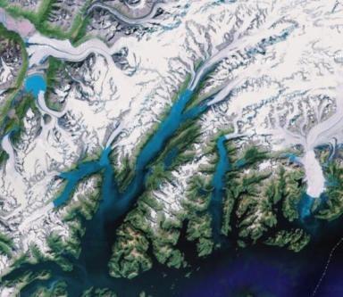
24 Fjords 24
Prentice Hall EARTH SCIENCE
 Prentice Hall EARTH SCIENCE Tarbuck Lutgens Chapter 7 Glaciers, Desert, and Wind 7.1 Glaciers Types of Glaciers A glacier is a thick ice mass that forms above the snowline over hundreds or thousands of
Chapter 5: Glaciers and Deserts
 I. Glaciers and Glaciation Chapter 5: Glaciers and Deserts A. A thick mass of ice that forms over land from the compaction and recrystallization of snow and shows evidence of past or present flow B. Types
1/6/ th Grade Earth s Surface. Chapter 3: Erosion and Deposition. Lesson 1 (Mass Movement)
") Lesson 1 (Mass Movement) 7 th Grade Earth s Surface Chapter 3: Erosion and Deposition Weathering the chemical and physical processes that break down rock at Earth s surface Mechanical weathering when rock
Lesson 1 (Mass Movement) 7 th Grade Earth s Surface Chapter 3: Erosion and Deposition Weathering the chemical and physical processes that break down rock at Earth s surface Mechanical weathering when rock
Read Across America. Listen as I read for facts about Volcanoes. In the Shadow of the Volcano
 Read Across America Listen as I read for facts about Volcanoes. In the Shadow of the Volcano Constructive & Destructive Processes Earth s surface is always changing. Blowing wind and flowing water causes
Chapter 3 Erosion and Deposition. The Big Question:
 Chapter 3 Erosion and Deposition The Big Question: 1 Design a way to represent and describe the 4 types of mass movement. You may use pictures, diagrams, list, web, chart, etc 2 Chapter 3: Erosion and
EROSION AND DEPOSITION
 CHAPTER 8 EROSION AND DEPOSITION SECTION 8 1 Changing Earth s Surface (pages 252-255) This section explains how sediment is carried away and deposited elsewhere to wear down and build up Earth s surface.
Name: Class: Date: Multiple Choice Identify the letter of the choice that best completes the statement or answers the question.
 Name: Class: Date: geology ch 7 test 2008 Multiple Choice Identify the letter of the choice that best completes the statement or answers the question. 1. Which of the following is true about ice sheets?
Erosion and Deposition
 CHAPTER 3 LESSON 2 Erosion and Deposition Landforms Shaped by Water and Wind Key Concepts What are the stages of stream development? How do water erosion and deposition change Earth s surface? How do wind
Changing Earth s Surface
 Name Date Class Changing Earth s Surface What processes wear down and build up Earth s surface? What causes the different types of mass movement? Erosion is the process by which natural forces move weathered
Prentice Hall EARTH SCIENCE
 Prentice Hall EARTH SCIENCE Tarbuck Lutgens Chapter 10 Volcanoes and Other Igneous Activity 10.1 The Nature of Volcanic Eruptions Factors Affecting Eruptions Factors that determine the violence of an eruption
Landforms and Rock Structure
 Landforms and Rock Structure Rock Structure as a Landform Control Landforms of Horizontal Strata and Coastal Plains Landforms of Warped Rock Layers Landforms Developed on Other Land-Mass Types Landforms
Erosion and Deposition
 Erosion and Deposition Erosion Sediment natural forces move rock/soil from one place to another. gravity, water, wind, glaciers, waves are causes material moved by erosion Deposition when erosion lays
4. The map below shows a meandering stream. Points A, B, C, and D represent locations along the stream bottom.
 1. Sediment is deposited as a river enters a lake because the A) velocity of the river decreases B) force of gravity decreases C) volume of water increases D) slope of the river increases 2. Which diagram
What are the different ways rocks can be weathered?
 Romano - 223 What are the different ways rocks can be weathered? Weathering - the breakdown of rocks and minerals at the Earth s surface 1. 2. PHYSICAL WEATHERING Rock is broken into smaller pieces with
Characteristics and processes associated with the development of Hilly Landscapes
 GRADE 11 GEOGRAPHY SESSION 1: GEOMORPHOLOGY I (TOPOGRAPHY) Key Concepts In this lesson we will focus on summarising what you need to know about: Topography associated with Horizontally Layered Rocks Topography
Erosion and Deposition
 Erosion and Deposition The Erosion-Deposition Process What do you think? Read the two statements below and decide whether you agree or disagree with them. Place an A in the Before column if you agree with
Continental Landscapes
 Continental Landscapes Landscape influenced by tectonics, climate & differential weathering Most landforms developed within the last 2 million years System moves toward an equilibrium Continental Landscapes
What is weathering and how does it change Earth s surface? Answer the question using
 7 th Grade Lesson What is weathering and how does it change Earth s surface? Answer the question using the sentence frame. You have 4 minutes. Weathering is. This changes the Earth s surface because. 1
Lecture Outlines PowerPoint. Chapter 6 Earth Science 11e Tarbuck/Lutgens
 Lecture Outlines PowerPoint Chapter 6 Earth Science 11e Tarbuck/Lutgens 2006 Pearson Prentice Hall This work is protected by United States copyright laws and is provided solely for the use of instructors
Bell Ringer. Are soil and dirt the same material? In your explanation be sure to talk about plants.
 Bell Ringer Are soil and dirt the same material? In your explanation be sure to talk about plants. 5.3 Mass Movements Triggers of Mass Movements The transfer of rock and soil downslope due to gravity is
Name. 4. The diagram below shows a soil profile formed in an area of granite bedrock. Four different soil horizons, A, B, C, and D, are shown.
 Name 1. In the cross section of the hill shown below, which rock units are probably most resistant to weathering? 4. The diagram below shows a soil profile formed in an area of granite bedrock. Four different
Folding. Faulting. Volcanoes
 Folding Faulting Volcanoes Most major global mountain ranges were formed by the collision of continental (tectonic) plates Fold mountains are actually formed by crust which have been uplifted and folded
Magma. Objectives. Describe factors that affect the formation of magma. Compare and contrast the different types of magma. Vocabulary.
 Magma Objectives Describe factors that affect the formation of magma. Compare and contrast the different types of magma. Vocabulary viscosity Magma Magma The ash that spews from some volcanoes can form
Name Class Date. Study Guide for 7 th Grade Final Exam (Semester One)
") Name Class Date Study Guide for 7 th Grade Final Exam (Semester One) 1. What are the steps of the scientific method? Define the problem or question Form a hypothesis (MUST BE TESTABLE) o (identify variables)
Name Class Date Study Guide for 7 th Grade Final Exam (Semester One) 1. What are the steps of the scientific method? Define the problem or question Form a hypothesis (MUST BE TESTABLE) o (identify variables)
Section 10.1 The Nature of Volcanic Eruptions This section discusses volcanic eruptions, types of volcanoes, and other volcanic landforms.
 Chapter 10 Section 10.1 The Nature of Volcanic Eruptions This section discusses volcanic eruptions, types of volcanoes, and other volcanic landforms. Reading Strategy Previewing Before you read the section,
Pratice Surface Processes Test
 1. The cross section below shows the movement of wind-driven sand particles that strike a partly exposed basalt cobble located at the surface of a windy desert. Which cross section best represents the
Foundations of Earth Science, 6e Lutgens, Tarbuck, & Tasa
 Foundations of Earth Science, 6e Lutgens, Tarbuck, & Tasa Glacial and Arid Landscapes Foundations, 6e - Chapter 4 Stan Hatfield Southwestern Illinois College Glaciers Glaciers are parts of two basic cycles
Landforms. Why does the land look like it does? 1. Controlled by water 2. Controlled by the rocks
 Landforms Why does the land look like it does? 1. Controlled by water 2. Controlled by the rocks Landforms Made by Running Water Stream erosion The evolution of a river system Entrenched meanders Fluvial
The Marine Environment
 The Marine Environment SECTION 16.1 Shoreline Features In your textbook, read about erosional landforms, beaches, estuaries, longshore currents, and rip currents. For each statement below, write or. 1.
YORK CASTLE HIGH SCHOOL CHRISTMAS TERM EXAMINATIONS GEOGRAPHY Duration 1 1 /2 HRS.
 GRADE 9 YORK CASTLE HIGH SCHOOL CHRISTMAS TERM EXAMINATIONS GEOGRAPHY Duration 1 1 /2 HRS. Name: 1. Label the internal structure of the earth provided below. WRITE on the space provide. Oceanic Crust/Upper
Weathering of Rocks. Weathering - Breakdown of rocks into pieces (sediment) 2 main types of weathering to rocks
 2 main types of weathering to rocks") Weathering of Rocks Weathering - Breakdown of rocks into pieces (sediment) 2 main types of weathering to rocks Mechanical weathering requires physical forces to break rocks into smaller pieces. Chemical
Weathering of Rocks Weathering - Breakdown of rocks into pieces (sediment) 2 main types of weathering to rocks Mechanical weathering requires physical forces to break rocks into smaller pieces. Chemical
Topic 6: Weathering, Erosion and Erosional-Deposition Systems (workbook p ) Workbook Chapter 4, 5 WEATHERING
 Workbook Chapter 4, 5 WEATHERING") Topic 6: Weathering, Erosion and Erosional-Deposition Systems (workbook p. 95-125) Workbook Chapter 4, 5 THE BIG PICTURE: Weathering, erosion and deposition are processes that cause changes to rock material
Topic 6: Weathering, Erosion and Erosional-Deposition Systems (workbook p. 95-125) Workbook Chapter 4, 5 THE BIG PICTURE: Weathering, erosion and deposition are processes that cause changes to rock material
2/23/2009. Visualizing Earth Science. Chapter Overview. Deserts and Drylands. Glaciers and Ice Sheets
 Visualizing Earth Science By Z. Merali and B. F. Skinner Chapter 6 Deserts, Glaciers and Ice Sheets Chapter Overview Deserts and Drylands Glaciers and Ice Sheets Deserts Geography Categorization of deserts
Chapter 10: Volcanoes and Other Igneous Activity Section 1: The Nature of Volcanic Eruptions I. Factors Affecting Eruptions Group # Main Idea:
 Chapter 10: Volcanoes and Other Igneous Activity Section 1: The Nature of Volcanic Eruptions I. Factors Affecting Eruptions Group # A. Viscosity Group # B. Dissolved Gases Group # II. Volcanic Material
Topography the natural and human features of the Earth s surface. ie. Surface features need to understand difference between relief and elevation
 Chapter 1 Landform Patterns and Processes Highlighted script will not be assessed Topography the natural and human features of the Earth s surface. ie. Surface features need to understand difference between
Unit Study Guide: Earth s Changing Surface
 Name Date Per Unit 8.3.2 Study Guide: Earth s Changing Surface I Can Statements I Can Statements are the learning targets for each unit. By the time you take the test for this unit, you should be able
Foundations of Earth Science, 6e Lutgens, Tarbuck, & Tasa
 Foundations of Earth Science, 6e Lutgens, Tarbuck, & Tasa Fires Within: Igneous Activity Foundations, 6e - Chapter 7 Stan Hatfield Southwestern Illinois College The nature of volcanic eruptions Characteristics
EARTH S CHANGING SURFACE
 EARTH S CHANGING SURFACE Weathering Together, weathering and erosion work continuously to wear down the material on Earth s surface. weathering process that breaks down rock and other substances of Earth
Magma. Objectives. Describe factors that affect the formation of magma. Compare and contrast the different types of magma. Vocabulary.
 Magma Objectives Describe factors that affect the formation of magma. Compare and contrast the different types of magma. Vocabulary viscosity Magma Magma The ash that spews from some volcanoes can form
The Agents of Erosion
 The Agents of Erosion 1. Erosion & Deposition 2. Water 3. Wind 4. Ice California Science Project 1 1. Erosion and Deposition Erosion is the physical removal and transport of material by mobile agents such
10/27/2014. Surface Processes. Surface Processes. Surface Processes. Surface Processes. Surface Processes
 Hewitt/Lyons/Suchocki/Yeh Conceptual Integrated Science Chapter 25 Surface or surficial processes originate at Earth's surface and reshape its contours. Surface processes include: Weathering Erosion Deposition
Examining the Terrestrial Planets (Chapter 20)
") GEOLOGY 306 Laboratory Instructor: TERRY J. BOROUGHS NAME: Examining the Terrestrial Planets (Chapter 20) For this assignment you will require: a calculator, colored pencils, a metric ruler, and your geology
GEOLOGY 306 Laboratory Instructor: TERRY J. BOROUGHS NAME: Examining the Terrestrial Planets (Chapter 20) For this assignment you will require: a calculator, colored pencils, a metric ruler, and your geology
STUDY GUIDE FOR CONTENT MASTERY. Surface Water Movement
 Surface Water SECTION 9.1 Surface Water Movement In your textbook, read about surface water and the way in which it moves sediment. Complete each statement. 1. An excessive amount of water flowing downslope
Physical Geology, 15/e
 Lecture Outlines Physical Geology, 15/e Plummer, Carlson & Hammersley Deserts & Wind Action Physical Geology 15/e, Chapter 13 Deserts Desert any arid region that receives less than 25 cm of precipitation
RIVERS, GROUNDWATER, AND GLACIERS
 RIVERS, GROUNDWATER, AND GLACIERS Delta A fan-shaped deposit that forms when a river flows into a quiet or large body of water, such as a lake, an ocean, or an inland sea. Alluvial Fan A sloping triangle
The Marine Environment
 The Marine Environment SECTION 16.1 Shoreline Features In your textbook, read about erosional landforms, beaches, estuaries, longshore currents, and rip currents. For each statement below, write true or
Constructive and Destructive Forces. Processes That Act Upon Earth s Surface Features
 Constructive and Destructive Forces Processes That Act Upon Earth s Surface Features What are Constructive and Destructive Forces? Constructive Force A constructive force is a process that raises or builds
CHAPTER 4 NOTES -WEATHERING AND EROSION- LESSON 4.1: TYPES OF WEATHERING
 CHAPTER 4 NOTES -WEATHERING AND EROSION- LESSON 4.1: TYPES OF WEATHERING WEATHERING Weathering- the process by which rocks are broken down by the forces of nature. - the breakdown of large rocks into fragments
core mantle crust the center of the Earth the middle layer of the Earth made up of molten (melted) rock
 rock") core the center of the Earth mantle the middle layer of the Earth made up of molten (melted) rock crust the surface layer of the Earth that includes the continents and oceans 1 continental drift the theory
core the center of the Earth mantle the middle layer of the Earth made up of molten (melted) rock crust the surface layer of the Earth that includes the continents and oceans 1 continental drift the theory
1. The diagram below shows the stump of a tree whose root grew into a small crack in bedrock and split the rock apart.
 1. The diagram below shows the stump of a tree whose root grew into a small crack in bedrock and split the rock apart. 4. Which process involves either a physical or chemical breakdown of earth materials?
1. Erosion by Running Water Most powerful cause of erosion
 I. Destructive Forces Notes: Destructive force: a process in which land is destroyed or changed such as weathering and erosion. All landforms are a result of a combination of constructive and destructive
 Page 1 of 9 Name: Base your answer to the question on the diagram below. The arrows show the direction in which sediment is being transported along the shoreline. A barrier beach has formed, creating a
MASS MOVEMENTS, WIND, AND GLACIERS
 Date Period Name MASS MOVEMENTS, WIND, AND GLACIERS SECTION.1 Mass Movements In your textbook, read about mass movements. Use each of the terms below just once to complete the passage. avalanche creep
Mass Movements, Wind, and Glaciers
 Mass Movements,, and Glaciers SECTION 8.1 Mass Movement at Earth s Surface In your textbook, read about mass movement. Use each of the terms below just once to complete the passage. avalanche creep landslide
Page 1. Name:
 Name: 1) Which event is the best example of erosion? dissolving of rock particles on a limestone gravestone by acid rain breaking apart of shale as a result of water freezing in a crack rolling of a pebble
When Mount St. Helens erupted, trapped gases caused the north side of the mountain to explode. Volcanic ash was ejected high into the atmosphere.
 When Mount St. Helens erupted, trapped gases caused the north side of the mountain to explode. Volcanic ash was ejected high into the atmosphere. A volcano is a mountain that forms when magma reaches the
A physical feature of the Earth s surface
 Earth s Landforms A physical feature of the Earth s surface A physical feature of the Earth s surface LANDFORM Highest of Earth s physical features Highest of Earth s physical features MOUNTAIN Low area
Basic Definitions. Landforms are the topographic features on the Earth s surface.
 Landforms and Geomorphology Basic Definitions Landforms are the topographic features on the Earth s surface. Geomorphology is the study of earth surface processes and landforms. The maps above represent
Geol 117 Lecture 18 Beaches & Coastlines. I. Types of Coastlines A. Definition:
 I. Types of Coastlines A. Definition: 1. Shore = narrow zone where ocean meets land (e.g. beach) 2. Coast is a broad area where both ocean and land processes act a. Includes onshore marshes, dunes, sea
Unit 3 Review - Surface Processes
 Unit 3 Review - Surface Processes 1. Why is the surface of Mercury covered with meteor impact craters, while Earth s surface has relatively few craters? A) Mercury is larger than Earth, so it gets hit
1. Any process that causes rock to crack or break into pieces is called physical weathering. Initial product = final product
 Weathering 1. Any process that causes rock to crack or break into pieces is called physical weathering. Initial product = final product End Result of physical weathering is increased surface area. 2. Physical
1 Shoreline Erosion and Deposition
 CHAPTER 12 1 Shoreline Erosion and Deposition SECTION Agents of Erosion and Deposition BEFORE YOU READ After you read this section, you should be able to answer these questions: What is a shoreline? How
water erosion lithosphere Describe the process of erosion and deposition. chemical weathering Dissolving limestone is an example of.
 At one time, there was one large island off the coast of Mississippi and now it is two separate islands. What caused the island to be split into two? water erosion The crust and the top part of the upper
Chapter 2. Wearing Down Landforms: Rivers and Ice. Physical Weathering
 Chapter 2 Wearing Down Landforms: Rivers and Ice Physical Weathering Weathering vs. Erosion Weathering is the breakdown of rock and minerals. Erosion is a two fold process that starts with 1) breakdown
Essential Questions. What is erosion? What is mass wasting?
 Erosion Essential Questions What is erosion? What is mass wasting? What is Erosion? Erosion The transportation of sediment from one area to another Caused mainly by running water but also caused by glaciers,
8UNIT. External dynamics of the Earth. What do you remember? Key language. Content objectives
 8UNIT External dynamics of the Earth What do you remember? Can you name the solids in the photograph? nd the liquid? Is the liquid moving? How does it move? What is the name of this formation of water?
WHAT IS A MAGMA. Magma is a mixture of molten rock, volatiles and solids that is found beneath the surface of the Earth.
 UNIT - 8 VOLCANOES WHAT IS A MAGMA Magma is a mixture of molten rock, volatiles and solids that is found beneath the surface of the Earth. In some instances, it solidifies within the crust to form plutonic
mountain rivers fixed channel boundaries (bedrock banks and bed) high transport capacity low storage input output
 high transport capacity low storage input output") mountain rivers fixed channel boundaries (bedrock banks and bed) high transport capacity low storage input output strong interaction between streams & hillslopes Sediment Budgets for Mountain Rivers Little
mountain rivers fixed channel boundaries (bedrock banks and bed) high transport capacity low storage input output strong interaction between streams & hillslopes Sediment Budgets for Mountain Rivers Little
Grade 5 Hands on Science Weathering, Erosion and Deposition
 Grade 5 Hands on Science Weathering, Erosion and Deposition Objective: To demonstrate and investigate the effect of weathering, water and wind erosion and the subsequent deposition into landforms. Background:
Introduction to Prospecting. Session Two Geology
 Introduction to Prospecting Session Two Geology The Earth Earth is 4.6 billion years old (Ba). Bacteria & algae +3.5 Ba. Microscopic animals ~2 Ba. Animals ~600 million years (Ma) old. Mankind about 100,000
Name: Which rock layers appear to be most resistant to weathering? A) A, C, and E B) B and D
 A, C, and E B) B and D") Name: 1) The formation of soil is primarily the result of A) stream deposition and runoff B) precipitation and wind erosion C) stream erosion and mass movement D) weathering and biological activity 2)
Name: 1) The formation of soil is primarily the result of A) stream deposition and runoff B) precipitation and wind erosion C) stream erosion and mass movement D) weathering and biological activity 2)
Surface Events & Landforms. Mrs. Green
 Surface Events & Landforms Mrs. Green Bell Work 1) Which event MOST likely causes the slowest change to the surface of Earth? a) Earthquake b) Landslide c) Volcano d) Wind 2) When cold weather freezes
Directed Reading. Section: Volcanoes and Plate Tectonics
 Skills Worksheet Directed Reading Section: Volcanoes and Plate Tectonics 1. Some volcanic eruptions can be more powerful than a(n) a. hand grenade. b. earthquake. c. geyser. d. atomic bomb. 2. The cause
Geomorphology Final Exam Study Guide
 Geomorphology Final Exam Study Guide Geologic Structures STRUCTURAL GEOLOGY concerned with shapes, arrangement, interrelationships of bedrock units & endogenic (within) forces that cause them. Tectonic
Tips for Success on a Test
 Number of Incorrect: Final Grade: Parent Signature: Top Tips for Success on a Test 1. Read the following statements at least two times. 2. Circle the key words in each question/ or statement. (*Remember
Chapter 18 - Volcanic Activity. Aka Volcano Under the City
 Chapter 18 - Volcanic Activity Aka Volcano Under the City 18.1 Magma Describe factors that affect the formation of magma. Compare and contrast the different types of magma. Temperature and pressure increase
STAAR 2013 #20; RC3; Readiness 1. Glaciers are masses of ice that move slowly on land. Which of these features was most likely formed by a glacier?
 Earth oot amp #1 5.7 Recognize how landforms such as deltas, canyons, and sand dunes are the result of changes to Earth s surface by wind, water, and ice. STR 2013 #20; R3; Readiness 1. Glaciers are masses
Chapter 2. Denudation: Rivers and Ice
 Chapter 2. Denudation: Rivers and Ice DENUDATION: process that lowers level of land - caused by rivers, glaciers, waves & wind - involves processes of WEATHERING & EROSION Weathering Def: breakdown of
Ch 10 Deposition Practice Questions
 1. Base your answer to the following question on the data table below. Six identical cylinders, A through F, were filled with equal volumes of sorted spherical particles. The data table shows the particle
 12 10 8 6 4 2 0 40-50 50-60 60-70 70-80 80-90 90-100 Fresh Water What we will cover The Hydrologic Cycle River systems Floods Groundwater Caves and Karst Topography Hot springs Distribution of water in
Engineering Geology ECIV 2204
 Engineering Geology ECIV 2204 2017-2016 Chapter (4) Volcanoes Chapter 4: Volcanoes and Other Igneous Activity cataclysmic relating to or denoting a violent natural even Eventually the entire
Rocks don't form into the three types of rocks and stay there. The Earth is constantly changing and in motion. The rock cycle demonstrates how a rock
 Rocks don't form into the three types of rocks and stay there. The Earth is constantly changing and in motion. The rock cycle demonstrates how a rock can start out as one type and change into another.
Goal 2.1 Forces in the Lithosphere. Volcanic Activity
 Goal 2.1 Forces in the Lithosphere Volcanic Activity Lesson 3 Volcanoes, Part 1 Think About It What happens when you shake a can of soda and then open it? Focus Question How does the composition of magma
World Geography 3202 Unit 1. Ch. 1: Landform Patterns and Processes
 World Geography 3202 Unit 1 Ch. 1: Landform Patterns and Processes - Planet Earth is dynamic - behaves as if it s a living organism - some changes are rapid enough for us to see and record - exs. Tidal
Visualizing Earth Science. Chapter Overview. Volcanoes and Eruption Types. By Z. Merali and B. F. Skinner. Chapter 9 Volcanism and Other
 Visualizing Earth Science By Z. Merali and B. F. Skinner Chapter 9 Volcanism and Other Igneous Processes Volcanoes types and effects of eruption Chapter Overview Melting and cooling of rocks Geological
Science EOG Review: Landforms
 Mathematician Science EOG Review: Landforms Vocabulary Definition Term canyon deep, large, V- shaped valley formed by a river over millions of years of erosion; sometimes called gorges (example: Linville
Section I: Multiple Choice Select the best answer to each question. Mark your final answer on the answer sheet. (1 pt each)
") Sedimentary Rocks & Surface Processes Quest Name: Earth Science 2013 Block: Date: Section I: Multiple Choice Select the best answer to each question. Mark your final answer on the answer sheet. (1 pt each)
Sedimentary Rocks & Surface Processes Quest Name: Earth Science 2013 Block: Date: Section I: Multiple Choice Select the best answer to each question. Mark your final answer on the answer sheet. (1 pt each)
Abrasion: The physical weathering of rocks by particles rubbing against each other.
 FOSS Earth History Course Glossary (10-4-04) Abrasion: The physical weathering of rocks by particles rubbing against each other. Absolute age: The exact age of an object (such as a rock or artifact); found
7/4/2018. Deserts and Winds
 1 2 3 4 5 6 7 8 9 10 11 12 13 14 15 16 17 18 Deserts and Winds Earth Chapter 19 Chapter 19 Deserts & Winds What Is Meant by Dry? A dry climate is one where yearly precipitation is not as great as the potential
deep within the planet. They are also shaped by conditions on the planet s surface. In
 Chapter 4 Landforms, Water, and Natural Resources Earth is home to many different types of landforms. These landforms are shaped by forces deep within the planet. They are also shaped by conditions on
Erosion Surface Water. moving, transporting, and depositing sediment.
 + Erosion Surface Water moving, transporting, and depositing sediment. + Surface Water 2 Water from rainfall can hit Earth s surface and do a number of things: Slowly soak into the ground: Infiltration
1. The map below shows a meandering river. A A' is the location of a cross section. The arrows show the direction of the river flow.
 1. The map below shows a meandering river. A A' is the location of a cross section. The arrows show the direction of the river flow. Which cross section best represents the shape of the river bottom at
TAKE HOME EXAM 8R - Geology
 Name Period Date TAKE HOME EXAM 8R - Geology PART 1 - Multiple Choice 1. A volcanic cone made up of alternating layers of lava and rock particles is a cone. a. cinder b. lava c. shield d. composite 2.
Unit 4: Landscapes Practice Problems
 Name: Date: 1. Soil with the greatest porosity has particles that are A. poorly sorted and densely packed B. poorly sorted and loosely packed C. well sorted and densely packed D. well sorted and loosely
A bowl shaped depression formed by the collapse of a volcano is called a. Magma that has left the vent of a volcano is known as. Lava.
 Magma that has left the vent of a volcano is known as Lava A bowl shaped depression formed by the collapse of a volcano is called a Caldera This can form in a caldera when magma starts to come back up
Unit 7.2 W.E.D. & Topography Test
 Name: Score: Unit 7.2 W.E.D. & Topography Test 1. 2. 3. 4. 5. 6. 7. 8. 9. 10. 11. 12. 13. 14. 15. 16. 17. 18. 19. 20. 21. 22. 23. 24. 25. 1. The formation of mountains is due mainly to while the destruction
THE EARTH S RELIEF SOCIAL SCIENCES 1º ESO
 THE EARTH S RELIEF SOCIAL SCIENCES 1º ESO 1. THE STRUCTURE OF THE EARTH The Earth is divided into layers: The crust is the surface layer. It is a thin, solid layer made of rock. The Earth s crust has a
Exploring Geography. Chapter 1. Chapter 1, Section
 Chapter 1, Section World Geography Chapter 1 Exploring Geography Copyright 2003 by Pearson Education, Inc., publishing as Prentice Hall, Upper Saddle River, NJ. All rights reserved. Chapter 1, Section
Overview of Ch. 4. I. The nature of volcanic eruptions 9/19/2011. Volcanoes and Other Igneous Activity Chapter 4 or 5
 Overview of Ch. 4 Volcanoes and Other Igneous Activity Chapter 4 or 5 I. Nature of Volcanic Eruptions II. Materials Extruded from a Volcano III.Types of Volcanoes IV.Volcanic Landforms V. Plutonic (intrusive)
Streams. Water. Hydrologic Cycle. Geol 104: Streams
 Streams Why study streams? Running water is the most important geologic agent in erosion, transportation and deposition of sediments. Water The unique physical and chemical properties of water make it