The River Continuum Concept (or not?) Stream Classification
|
|
|
- Blake Heath
- 5 years ago
- Views:
Transcription
 Stream Classification Goal: Generalization 2 ge")
1 The River Continuum Concept (or not?) Stream Classification Goal: Generalization 2 general types of classification streams (longitudinal) streams (e.g., hydrologic regime classification) Longitudinal Classification What Changes? 1

 Hard to")


2 transition zones Zonation (1 & 2 above) Convenient, works in many drainages Can account for discontinuities (e.g., foothill / plains transition) Hard to generalize broadly Continuum maybe more general? Zonation schemes 1) characteristics Width/depth, gradient, temperature, substrate, etc. 2) zonation Fish -- Huet (1949) 4 zones: Trout Grayling Barbel Bream 2
 * = river (> 20 C) Illies & Botsaneanu worldwide classification system General Categories Rhithron O 2 always high High gradient flow is fast and turbulent Coarse substrates erosional")
3 Zonation schemes 3) Combination of Physical and Biotic Illies (1961) and Illies & Botsaneanu (1963), a worldwide classification system Kryon = glacier brook (1-5 C) Crenon = spring * = stream (annual T range <20 C) * = river (> 20 C) Illies & Botsaneanu worldwide classification system General Categories Rhithron O 2 always high High gradient flow is fast and turbulent Coarse substrates erosional No plankton Macroinverts are cold stenotherms (lotic forms) cool-water, cold-water fish Potamon Warm stenotherms/ eurytherms Facultative rheophiles Some plankton rhithron potamon über classification Fig. 4.19, Ward 1992 crenon 3
4 The River Continuum Concept (RCC) Vannote et al. (1980) Continuum Idea of gradual change works in many drainages Textbook (Allan textbook, 1995): Bold attempt to construct a single synthetic framework to describe the structure and function of lotic ecosystems from source to mouth. Textbook (Allan & Castillo textbook, 2007): proven to be a resilient encapsulation of the relative roles played by different basal resources along an idealized river systems. Furthermore, the longitudinal distribution of functional feeding groups often, although not invariably, can be shown to be at least approximately in accord with expectations. The River Continuum Concept (RCC) General Idea in physical conditions and energy sources as you go from headwaters to mouth lead to biotic What are the predictable changes? Changes in canopy cover, energy sources, temperature, hydrologic regime What are the biotic adjustments? Biotic responses to available,, physical downstream species replacements and change in functional groups 4

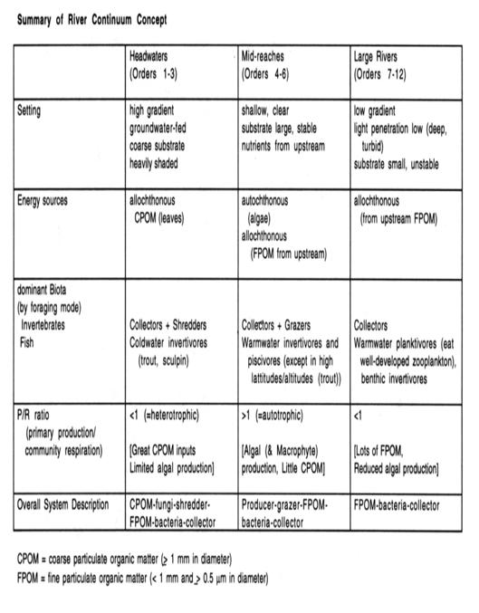
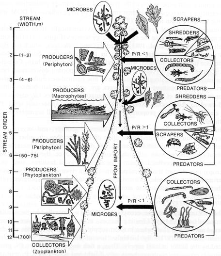
5 Assumptions of RCC Headwater Streams 1) heavily-canopied with vegetation 2) fed 3) coarse substrate 4) 5) nutrient-poor 6) undisturbed (by humans) RCC Patterns/Predictions Break the continuum into segments (zonation?) 1) Headwaters (Orders 1-3) 2) Mid-reaches (Orders 4-6) 3) Large Rivers (Orders 7-12) *What are the main predictions for each of these size domains? 5
6 6
7 Exercise Graph the following (given RCC assumptions): Physico-chemical Factors Substrate Size Bottom Light Diel T Annual Δ T Annual Δ Q Environmental Heterogeneity Energy Sources CPOM/FPOM Nutrient Levels Nutrient Availability (to 1 Producers) P/R Diversity (Richness) Benthos Fish Algae Macrophytes Plankton substrate size bottom light diel Δ T annual Δ T annual Δ Q Environmental Heterogeneity CPOM / FPOM Nutrient Levels Nutrient Availability P / R Benthic Diversity Fish Diversity Algal Diversity Macrophyte Diversity Plankton Stream Order Stream Order Stream Order 7

8 Evidence for RCC predictions? Grubaugh et al. (1996) Fig from text Criticisms of RCC Assumptions Some streams have substantial headwaters Some streams lack sources can 'reset continuum Can import CPOM, coarse substrate, cooler water, etc. Absence of in some canopied headwaters due to zoogeography (e.g., islands) Downstream sources of (floodplains) Historical alterations of large rivers create artifacts beavers floodplain disconnection Allan book: Perhaps the generality of the RCC is a handicap when it is applied to a multitude of specific situations. 8
 are usually observable (e.g., CPOM vs. FPOM, shredders vs.")
9 Legacy / Importance of RCC Enduring Insights: 1) Stream organisms "predictably" structured along longitudinal resource gradients, reflecting changes in energy inputs temperature 2) Downstream communities depend on upstream processes Scales of application The very big differences (e.g., Headwaters vs. Mouth) are usually observable (e.g., CPOM vs. FPOM, shredders vs. collectors) But differences among sites along the continuum are often obscure due to local variation Main value, and limitation A conceptual framework for viewing whole river basins, with a focus on linear, upstream-downstream linkages RCC is a theory about the mean state of the system along the longitudinal profile, NOT the variance How to account for variation within continuum? tributary 9
 Tributary interruptions of Continuum Link Discontinuity Concept Rice, S.P., M.T. Greenwood, and C.B. Joyce. 2001.")
10 How to account for variation within continuum? 1) Transition zones in Continuum Process Domain Concept Montgomery, D.R Process Domains and the River Continuum Concept. J. Am. Water Res. Assoc. 35: ) Tributary interruptions of Continuum Link Discontinuity Concept Rice, S.P., M.T. Greenwood, and C.B. Joyce Tributaries, sediment sources, and the longitudinal organisation of macroinvertebrate fauna along river systems. Can. J. Fish. Aquatic. Sci. 58: Network Dynamics Hypothesis Benda, L., N.L. Poff, D. Miller, T. Dunne, G. Reeves, G. Pess, and M. Pollock The network dynamics hypothesis: how channel networks structure riverine habitats. BioScience 54: Process Domain Concept Geomorphology controls disturbance regime which controls ecological organization Developed for higher gradient, montane streams Prediction: Aquatic communities will be similar in same domain even if stream size varies somewhat A B For example: compare A and B (same domain) versus A and C (same stream size but different domains) C Some evidence supporting, but not well tested. 10
, the water volume, bed sediment character, and water quality of the mainstream can change abruptly.")

11 Tributaries: Link Discontinuity Concept Tributary are sites along a main channel where, because of the introduction of water and (or), the water volume, bed sediment character, and water quality of the mainstream can change abruptly. Hypothesis: The arrangement of tributaries and related features is an important control on the longitudinal organisation of macroinvertebrate benthos at moderate spatial scales. 4 Lateral sediment sources (LSSs) are marked by arrows and delineate links in the Pine study reach (Rice et al. 2001) 11
12 D 50 Distance downstream (km) Some step-like changes in physicalchemical variables at tributary junctions. Some re-setting of benthic inverts below tributary junctions. Tributaries: Network Dynamics Hypothesis River network is a population of tributaries and their confluences. Tributaries interrupt river continuum inputs of water, sediment and organic material at tributary junctions varies in time depending on disturbance in the trib s watershed Degree of interruption depends on size of tributary relative to mainstem, which in turn depends on network geometry. Temporal cause confluence effects to wax and wane over time. Shape of network, coupled with watershed disturbance regime, influence habitat and therefore will also influence ecological. 12
.")
13 Effects of disturbance (sediment inputs) in a tributary watershed on mainstem river floodplain lower upstream channel, meandering upstream; steeper gradient downstream deposition of woody debris and sediment overall increase in habitat An alluvial fan enlarged following a fire triggers tributary junction effects in the North Fork Boise River (320 km2 drainage area). Junction effects include expanded floodplains, and increased channel meandering and side channels upstream of the fan (from Benda et al Degree of heterogeneity is determined by size of sediment input (and also size of tributary relative to mainstem). Closely-spaced confluences also yield bigger effects. 13


14 Size of tributaries influences confluence effects (bigger in relation to mainstem bigger effect). Therefore, the basin shape is important in predicting the overall influence of confluence effects in the whole system. Comparisons of predictions River Continuum Network Dynamics Conclusion: accounting for tributary influences may help explain longitudinal deviations from the central tendencies predicted by a linear continuum hypothesis. 14
Lower South Fork McKenzie River Floodplain Enhancement Project
 Lower South Fork McKenzie River Floodplain Enhancement Project McKenzie River Ranger District Willamette National Forest Project Location The project is located in the South Fork McKenzie River Watershed,
Principles of fluvial geomorphology have guided
 The Network Dynamics Hypothesis: How Channel Networks Structure Riverine Habitats LEE BENDA, N. LEROY POFF, DANIEL MILLER, THOMAS DUNNE, GORDON REEVES, GEORGE PESS, AND MICHAEL POLLOCK Hierarchical and
The Network Dynamics Hypothesis: How Channel Networks Structure Riverine Habitats
 The Network Dynamics Hypothesis: How Channel Networks Structure Riverine Habitats Author(s): LEE BENDA, N. LEROY POFF, DANIEL MILLER, THOMAS DUNNE, GORDON REEVES, GEORGE PESS, and MICHAEL POLLOCK Source:
Conceptual Model of Stream Flow Processes for the Russian River Watershed. Chris Farrar
 Conceptual Model of Stream Flow Processes for the Russian River Watershed Chris Farrar Several features of creeks affect the interactions between surface and groundwater. This conceptual model uses the
BZ471, Steam Biology & Ecology Exam
 BZ471, Eam1, p.1 BZ471, Steam Biology & Ecology Eam Name Multiple choice When benthic organisms enter the water column with a regular diel periodicity: a) catastrophic drift b) behavioral drift c) constant
Dan Miller + Kelly Burnett, Kelly Christiansen, Sharon Clarke, Lee Benda. GOAL Predict Channel Characteristics in Space and Time
 Broad-Scale Models Dan Miller + Kelly Burnett, Kelly Christiansen, Sharon Clarke, Lee Benda GOAL Predict Channel Characteristics in Space and Time Assess Potential for Fish Use and Productivity Assess
How Do Human Impacts and Geomorphological Responses Vary with Spatial Scale in the Streams and Rivers of the Illinois Basin?
 How Do Human Impacts and Geomorphological Responses Vary with Spatial Scale in the Streams and Rivers of the Illinois Basin? Bruce Rhoads Department of Geography University of Illinois at Urbana-Champaign
ADDRESSING GEOMORPHIC AND HYDRAULIC CONTROLS IN OFF-CHANNEL HABITAT DESIGN
 ADDRESSING GEOMORPHIC AND HYDRAULIC CONTROLS IN OFF-CHANNEL HABITAT DESIGN Conor Shea - Hydrologist U.S. Fish and Wildlife Service Conservation Partnerships Program Arcata, CA Learning Objectives Examine
Use of benthic invertebrate biological indicators in evaluating sediment deposition impairment on the Middle Truckee River, California
 Use of benthic invertebrate biological indicators in evaluating sediment deposition impairment on the Middle Truckee River, California David B. Herbst Sierra Nevada Aquatic Research Laboratory University
Monitoring Headwater Streams for Landscape Response to
 Monitoring Headwater Streams for Landscape Response to Climate Change Matthew Connor, PhD Connor nvironmental, nc. www.oe-i.com icom Healdsburg, California verview Headwater stream geomorphology Response
The Effects of Geomorphology and Watershed Land Use on Spawning Habitat
 The Effects of Geomorphology and Watershed Land Use on Spawning Habitat By Evan Buckland INTRODUCTION The distribution and frequency of large geomorphic features in a watershed govern where suitable spawning
The Danube River. Hydrological Connectivity and Human Influence. By: Pat O Connell, Pat Wilkins, Tiana Royer, and Kevin Gaitsch
 The Danube River Hydrological Connectivity and Human Influence By: Pat O Connell, Pat Wilkins, Tiana Royer, and Kevin Gaitsch Danube River Characteristics Length: 2860 km Drainage Area: 816,000 km 2 Peak
Fact sheet: Glacial rivers (all Europe)
") Fact sheet: Glacial rivers (all Europe) General description Valleyplanform Hydrology and The valley form varies from a gorge to a V-shaped valley and the single-thread channel is mainly characterized by
Fact sheet: Glacial rivers (all Europe) General description Valleyplanform Hydrology and The valley form varies from a gorge to a V-shaped valley and the single-thread channel is mainly characterized by
River Nith restoration, cbec UK Ltd, October 2013 APPENDIX A
 APPENDIX A FLUVIAL AUDIT METHOD STATEMENT Fluvial Audit Methodology INTRODUCTION The procedure used to characterize the geomorphic and sedimentary regimes of the River Till is an adaptation of the Fluvial
Riparian Assessment. Steps in the right direction... Drainage Basin/Watershed: Start by Thinking Big. Riparian Assessment vs.
 Riparian Assessment vs. Monitoring Riparian Assessment What is a healthy stream? Determine stream/riparian health Determine change or trend, especially in response to mgmt Classification = designation
Monitoring and evaluation of benthic macroinvertebrates in the Big Hole River and tributaries
 Monitoring and evaluation of benthic macroinvertebrates in the Big Hole River and tributaries Michael A. Bias Big Hole River Foundation Introduction BMI used to evaluate stream biological health Quantifies
Wetland & Floodplain Functional Assessments and Mapping To Protect and Restore Riverine Systems in Vermont. Mike Kline and Laura Lapierre Vermont DEC
 Wetland & Floodplain Functional Assessments and Mapping To Protect and Restore Riverine Systems in Vermont Mike Kline and Laura Lapierre Vermont DEC NWI+ Hydro-Geomorphic Characterization of Wetlands and
Squaw Creek. General Information
 General Information is a tributary to the Salmon River. It enters the north side of the river about 0 miles downstream of North Fork, Idaho. The study reach is about a 30 ft length of stream about 2 miles
Mobrand to Jones and Stokes. Sustainable Fisheries Management Use of EDT
 Sustainable Fisheries Management Use of EDT Ecosystem Diagnosis and Treatment EDT EDT designed to provide a practical, science-based approach for developing and implementing watershed plans. Provides decision
Birch Creek Geomorphic Assessment and Action Plan
 Birch Creek Geomorphic Assessment and Action Plan Jim Webster Tim Hanrahan, PhD, CFM Jesse Schwartz, PhD Zach Hill January 22, 2015 White Eagle Grange This Project is a First Step in Strategy Planning
NATURAL RIVER. Karima Attia Nile Research Institute
 NATURAL RIVER CHARACTERISTICS Karima Attia Nile Research Institute NATURAL RIVER DEFINITION NATURAL RIVER DEFINITION Is natural stream of water that flows in channels with ih more or less defined banks.
Use of Space-for-Time Substitution in River Restoration: examples from SE England
 Use of Space-for-Time Substitution in River Restoration: examples from SE England Drs Andrew Brookes and Niamh Burke (Jacobs) Lizzie Rhymes and Graham Scholey (Environment Agency, SE) What is Space-for-Time
Step 5: Channel Bed and Planform Changes
 Step 5: Channel Bed and Planform Changes When disturbed, streams go through a series of adjustments to regain equilibrium with the flow and sediment supply of their watersheds. These adjustments often
SCOPE OF PRESENTATION STREAM DYNAMICS, CHANNEL RESTORATION PLANS, & SEDIMENT TRANSPORT ANALYSES IN RELATION TO RESTORATION PLANS
 DESIGN METHODS B: SEDIMENT TRANSPORT PROCESSES FOR STREAM RESTORATION DESIGN PETER KLINGEMAN OREGON STATE UNIVERSITY CIVIL ENGINEERING DEPT., CORVALLIS 2 ND ANNUAL NORTHWEST STREAM RESTORATION DESIGN SYMPOSIUM
Erosion Surface Water. moving, transporting, and depositing sediment.
 + Erosion Surface Water moving, transporting, and depositing sediment. + Surface Water 2 Water from rainfall can hit Earth s surface and do a number of things: Slowly soak into the ground: Infiltration
Running Water Earth - Chapter 16 Stan Hatfield Southwestern Illinois College
 Running Water Earth - Chapter 16 Stan Hatfield Southwestern Illinois College Hydrologic Cycle The hydrologic cycle is a summary of the circulation of Earth s water supply. Processes involved in the hydrologic
OBJECTIVES. Fluvial Geomorphology? STREAM CLASSIFICATION & RIVER ASSESSMENT
 STREAM CLASSIFICATION & RIVER ASSESSMENT Greg Babbit Graduate Research Assistant Dept. Forestry, Wildlife & Fisheries Seneca Creek, Monongahela National Forest, West Virginia OBJECTIVES Introduce basic
Tom Ballestero University of New Hampshire. 1 May 2013
 Tom Ballestero University of New Hampshire 1 May 2013 1 Hydrology 2 Basic Hydrology Low flows most common Flows that fill the stream to the banks and higher are much less common Filling the stream to the
Freshwater-Tidal Gradients: Eco-geomorphology Linkages to Watershed-Estuarine Dynamics
 Freshwater-Tidal Gradients: Eco-geomorphology Linkages to Watershed-Estuarine Dynamics Kathy Boomer (The Nature Conservancy) Scott Ensign (Stroud Research) Greg Noe (USGS) Concluding Speculations: It s
Addendum to Upper Clark Fork River Tributaries Sediment, Metals, and Temperature TMDLs and Framework for Water Quality Restoration Appendix J
 APPENDIX J BROWNS GULCH SEDIMENT ASSESSMENT TABLE OF CONTENTS J1.0 Introduction... J-3 J2.0 Physical Watershed Characteristics... J-3 J2.1 Soils/Sediment... J-5 J2.2 Hydrology... J-5 J2.3 Rosgen Classification...
Variety is the spice of river life: recognizing hydraulic diversity as a tool for managing flows in regulated rivers
 Sediment Dynamics and the Hydromorphology of Fluvial Systems (Proceedings of a symposium held in Dundee, UK, July 2006). IAHS Publ. 306, 2006. 169 Variety is the spice of river life: recognizing hydraulic
GENERAL SUMMARY BIG WOOD RIVER GEOMORPHIC ASSESSMENT BLAINE COUNTY, IDAHO
 GENERAL SUMMARY BIG WOOD RIVER GEOMORPHIC ASSESSMENT BLAINE COUNTY, IDAHO Prepared For Trout Unlimited 300 North Main Street, Hailey, Idaho, 83333 Prepared By P. O. Box 8578, 140 E. Broadway, Suite 23,
Geomorphology Studies
 Geomorphology Studies Technical Workgroup Meeting February 14, 2012 Prepared by: Tetra Tech Prepared for: Alaska Energy Authority Overall Goal Geomorphology Studies Two studies Geomorphology Study (RSP
The River Restoration Centre therrc.co.uk. Understanding Fluvial Processes: supporting River Restoration. Dr Jenny Mant
 The River Restoration Centre therrc.co.uk Understanding Fluvial Processes: supporting River Restoration Dr Jenny Mant Jenny@therrc.co.uk Understanding your catchment Hydrology Energy associated with the
Session C1 - Applying the Stream Functions Pyramid to Geomorphic Assessments and Restoration Design
 University of Massachusetts - Amherst ScholarWorks@UMass Amherst International Conference on Engineering and Ecohydrology for Fish Passage International Conference on Engineering and Ecohydrology for Fish
CR AAO Bridge. Dead River Flood & Natural Channel Design. Mitch Koetje Water Resources Division UP District
 CR AAO Bridge Dead River Flood & Natural Channel Design Mitch Koetje Water Resources Division UP District Old County Road AAO Bridge Map courtesy of Marquette County Silver Lake Basin McClure Basin
Unconventional Wisdom and the Effects of Dams on Downstream Coarse Sediment Supply. Byron Amerson, Jay Stallman, John Wooster, and Derek Booth
 Unconventional Wisdom and the Effects of Dams on Downstream Coarse Sediment Supply 3 February 2009 Byron Amerson, Jay Stallman, John Wooster, and Derek Booth Sultan River, WA OBJECTIVE Consider the landscape
OVERVIEW FISH 404: RIVER ECOLOGY SEMESTER IN THE WILD, APPROX. AUG 27-SEPT 19, 2015 INSTRUCTORS. BRIAN KENNEDY
 FISH 404: RIVER ECOLOGY SEMESTER IN THE WILD, APPROX. AUG 27-SEPT 19, 2015 INSTRUCTORS BRIAN KENNEDY kennedy@uidaho.edu OTHER INSTRUCTIONAL ASSISTANTS DR. MARIUS MYRVOLD kmyrvold@uidaho.edu BRYCE OLDEMEYER,
Summary. Streams and Drainage Systems
 Streams and Drainage Systems Summary Streams are part of the hydrologic cycle and the chief means by which water returns from the land to the sea. They help shape the Earth s surface and transport sediment
Biological Response to the Gold King Mine Release in the Animas and San Juan Rivers
 Biological Response to the Gold King Mine Release in the and San Juan Rivers Lareina Guenzel 1, Richard Mitchell, PhD 1, Kate Sullivan, PhD 2, and Michael Cyterski, PhD 2 1 U.S. Environmental Protection
low turbidity high turbidity
 What is Turbidity? Turbidity refers to how clear the water is. The greater the amount of total suspended solids (TSS) in the water, the murkier it appears and the higher the measured turbidity. Excessive
STREAM SYSTEMS and FLOODS
 STREAM SYSTEMS and FLOODS The Hydrologic Cycle Precipitation Evaporation Infiltration Runoff Transpiration Earth s Water and the Hydrologic Cycle The Hydrologic Cycle The Hydrologic Cycle Oceans not filling
Precipitation Evaporation Infiltration Earth s Water and the Hydrologic Cycle. Runoff Transpiration
 STREAM SYSTEMS and FLOODS The Hydrologic Cycle Precipitation Evaporation Infiltration Earth s Water and the Hydrologic Cycle Runoff Transpiration The Hydrologic Cycle The Hydrologic Cycle Oceans not filling
3/3/2013. The hydro cycle water returns from the sea. All "toilet to tap." Introduction to Environmental Geology, 5e
 Introduction to Environmental Geology, 5e Running Water: summary in haiku form Edward A. Keller Chapter 9 Rivers and Flooding Lecture Presentation prepared by X. Mara Chen, Salisbury University The hydro
Streams. Stream Water Flow
 CHAPTER 14 OUTLINE Streams: Transport to the Oceans Does not contain complete lecture notes. To be used to help organize lecture notes and home/test studies. Streams Streams are the major geological agents
May 7, Roger Leventhal, P.E. Marin County Public Works Laurel Collins Watershed Sciences
 May 7, 2013 Roger Leventhal, P.E. Marin County Public Works Laurel Collins Watershed Sciences Background Funded in 2009 under EPA 2100 Grant for $30k and managed by SFEP Project Goals: Update original
1 INTRODUCTION AND MAJOR FINDINGS... 1
 Memorandum To: Lindsey Clark, Stillwater Valley Watershed Council Coordinator From: Chad Raisland, Pioneer Technical Services, Inc. and Karin Boyd, Applied Geomorphology, Inc. CC: Tanya Lester, Stillwater
Channel Assessments of Selected Watersheds within TFL 52
 Channel Assessments of Selected Watersheds within TFL 52 prepared for: West Fraser Mills Ltd. Quesnel, BC prepared by: John Berry, M.Sc., R.P.F. Victoria, BC Channel Assessments TFL 52 Summary SUMMARY
Learning Objectives: I can identify and interpret river flows and directions.
 Learning Objectives: I can identify and interpret river flows and directions. Bellringer Review: Check for Understanding Questions: 1 2 What Are The Key Parts Of A River s Anatomy? In your data notebooks
Clinton and Potter Counties, Pennsylvania
 Clinton and Potter Counties, Pennsylvania Prepared For: Trout Unlimited & Kettle Creek Watershed Association Prepared By: LARSON DESIGN GROUP, INC. 1000 COMMERCE PARK DRIVE WILLIAMSPORT, PA 17703-0487
Sediment and nutrient transport and storage along the urban stream corridor
 Sediment and nutrient transport and storage along the urban stream corridor Greg Noe, Cliff Hupp, Ed Schenk, Jackie Batson, Nancy Rybicki, Allen Gellis What is the role of floodplains everywhere? Noe 2013,
Ecosystem response during the removal of the Elwha River Dams
 Ecosystem response during the removal of the Elwha River Dams Presentation Prepared by George Pess - NOAA Photo by John McMillan December 2015 Elwha The Elwha River Basin Olympic Natl. Park > 90% of habitat
Landscape Development
 Landscape Development Slopes Dominate Natural Landscapes Created by the interplay of tectonic and igneous activity and gradation Deformation and uplift Volcanic activity Agents of gradation Mass wasting
SEDIMENT BENEFICIAL USE SUPPORT ASSESSMENT FOR OTTER CREEK
 SEDIMENT BENEFICIAL USE SUPPORT ASSESSMENT FOR OTTER CREEK Addresses Otter Creek Assessment Unit MT42C002_020 Prepared by: Kristy Fortman November 15, 2013 1 1.0 INTRODUCTION In the spring of 2013, the
Nutrient and Sediment Cycling and Retention in Urban Floodplain Wetlands
 Nutrient and Sediment Cycling and Retention in Urban Floodplain Wetlands Greg Noe, Cliff Hupp, Nancy Rybicki, Ed Schenk, and Jackie Batson National Research Program, Reston VA U.S. Department of the Interior
Opportunities to Improve Ecological Functions of Floodplains and Reduce Flood Risk along Major Rivers in the Puget Sound Basin
 Opportunities to Improve Ecological Functions of Floodplains and Reduce Flood Risk along Major Rivers in the Puget Sound Basin Christopher Konrad, US Geological Survey Tim Beechie, NOAA Fisheries Managing
BASIS FOR RIVER RESTORATION PROJECT
 The FLUVIO FCT-Doctoral Program Hydromorphological and Habitat Restoration Course Diego García de Jalón and Marta González del Tánago, UPM Madrid BASIS FOR RIVER RESTORATION PROJECT Throughout the course,
What is a watershed or landscape perspective?
 What is a watershed or landscape perspective? -remove sediment -add sediment -add wood, riparian manipulation -alter (engineer) channel/floodplain morphology -restore/abandon roads You are here What is
Assessment of Landscape Characterization and Classification Methods
 Assessment of Landscape Characterization and Classification Methods By Cara Berman Center for Water and Watershed Studies University of Washington Submitted to the USDA Forest Service Pacific Northwest
Four Mile Run Levee Corridor Stream Restoration
 Four Mile Run Levee Corridor Stream Restoration 30% Design Summary U.S. Army Corps of Engineers, Baltimore District Presentation Outline Four Mile Run 1.) Historic Perspective 2.) Existing Conditions 3.)
Vermont Stream Geomorphic Assessment. Appendix E. River Corridor Delineation Process. VT Agency of Natural Resources. April, E0 - April, 2004
 Vermont Stream Geomorphic Assessment Appendix E River Corridor Delineation Process Vermont Agency of Natural Resources - E0 - River Corridor Delineation Process Purpose A stream and river corridor delineation
Susitna-Watana Hydroelectric Project (FERC No ) Geomorphology Study Study Plan Section Study Implementation Report.
 Geomorphology Study Study Plan Section Study Implementation Report.") (FERC No. 14241) Geomorphology Study Study Plan Section 6.5 2014-2015 Study Implementation Report Prepared for Prepared by Tetra Tech Watershed GeoDynamics October 2015 TABLE OF CONTENTS 1. Introduction...
(FERC No. 14241) Geomorphology Study Study Plan Section 6.5 2014-2015 Study Implementation Report Prepared for Prepared by Tetra Tech Watershed GeoDynamics October 2015 TABLE OF CONTENTS 1. Introduction...
Fish Passage and Abundance around Grade Control Structures on Incised Streams in Western Iowa
 Fish Passage and Abundance around Grade Control Structures on Incised Streams in Western Iowa John Thomas Hungry Canyons Alliance Mary Culler Iowa State University / Missouri DNR Dimitri Dermisis IIHR
Phase I System Characterization: Year 2 Study Plans
 Phase I System Characterization: Year 2 Study Plans Year I Physical and Biological Data Sets Quarterly Storm Sampling Four storm events with 8 sample stations at bridges Monthly Baseline Characterization
Aerial Surveys in the Wenatchee River Basin Thermal Infrared and Color Videography
 Aerial Surveys in the Wenatchee River Basin Thermal Infrared and Color Videography December 12, 2002 Report to: Washington Department of Ecology P.O. Box 47600, Olympia, WA 98504-7600 by: Watershed Sciences,
Bishopville Prong Study
 Bathymetric and Sediment Assessment in the Bishopville Prong of St. Martin River Darlene V. Wells, Richard A. Ortt, Jr., and Stephen Van Ryswick Funded by MCBP 2011-2012 Implementation Grant Objectives
Surface Water and Stream Development
 Surface Water and Stream Development Surface Water The moment a raindrop falls to earth it begins its return to the sea. Once water reaches Earth s surface it may evaporate back into the atmosphere, soak
Aquifer an underground zone or layer of sand, gravel, or porous rock that is saturated with water.
 Aggradation raising of the streambed by deposition that occurs when the energy of the water flowing through a stream reach is insufficient to transport sediment conveyed from upstream. Alluvium a general
The Hydrologic Cycle STREAM SYSTEMS. Earth s Water and the Hydrologic Cycle. The Hydrologic Cycle. Hydrologic Cycle
 STREAM SYSTEMS Earth Science: Chapter 5 Reading pages 114-124 The Hydrologic Cycle Oceans not filling up Evaporation = precipitation System is balanced Earth s Water and the Hydrologic Cycle Earth s Water
Watershed concepts for community environmental planning
 Purpose and Objectives Watershed concepts for community environmental planning Dale Bruns, Wilkes University USDA Rural GIS Consortium May 2007 Provide background on basic concepts in watershed, stream,
Flow regime, floodplain inundation and floodplain waterbody connectivity at Congaree National Park
 Flow regime, floodplain inundation and floodplain waterbody connectivity at Congaree National Park John Kupfer Dept. of Geography Univ. of South Carolina Kimberly Meitzen Duke University Nature Conservancy
Rosgen Classification Unnamed Creek South of Dunka Road
 Rosgen Classification Unnamed Creek South of Dunka Road Prepared for Poly Met Mining Inc. September 2013 Rosgen Classification Unnamed Creek South of Dunka Road Prepared for Poly Met Mining Inc. September
Little Blackfoot TPA 2009 Sediment and Habitat Assessment QAQC Review March 9, 2010
 Little Blackfoot TPA 2009 Sediment and Habitat Assessment QAQC Review March 9, 2010 1.0 PROJECT OVERVIEW Sediment and habitat monitoring in the Little Blackfoot TPA was conducted in July of 2009 as outlined
Factors influencing nutrient and sediment retention by riverine wetlands in the Chesapeake watershed Greg Noe, Cliff Hupp, Ed Schenk, Nancy Rybicki
 Factors influencing nutrient and sediment retention by riverine wetlands in the Chesapeake watershed Greg Noe, Cliff Hupp, Ed Schenk, Nancy Rybicki National Research Program, Reston VA U.S. Department
Assignment 1. Measuring River Characteristics- Vernon Creek. Applied Fluvial Geomorphology Field Techniques EESc 435
 Assignment 1 Measuring River Characteristics- Vernon Creek Applied Fluvial Geomorphology Field Techniques EESc 435 Amanda Jardine 30100093 Jaime McDonald 14177083 Erica Massey 50870088 April 28, 2012 Introduction
Diagnostic Geomorphic Methods for Understanding Future Behavior of Lake Superior Streams What Have We Learned in Two Decades?
 Diagnostic Geomorphic Methods for Understanding Future Behavior of Lake Superior Streams What Have We Learned in Two Decades? Faith Fitzpatrick USGS WI Water Science Center, Middleton, WI fafitzpa@usgs.gov
Appendix 1. River/Stream Classification for the NTPE
 Appendix Page Appendix. River/Stream Classification for the NTPE A.. Aquatic Classification Framework One of the goals of the ecoregional planning process is to develop a strategy to protect ecosystems
DETAILED DESCRIPTION OF STREAM CONDITIONS AND HABITAT TYPES IN REACH 4, REACH 5 AND REACH 6.
 DETAILED DESCRIPTION OF STREAM CONDITIONS AND HABITAT TYPES IN REACH 4, REACH 5 AND REACH 6. The Eklutna River was divided into study reaches (figure 1) prior to this site visit. Prominent geologic or
Hydrologic Analysis for Ecosystem Restoration
 Hydrologic Analysis for Ecosystem Restoration Davis, California Objectives: To provide participants with: 1) an understanding of the issues in restoration studies; 2) an overview of Corps policies and
Implementing a Project with 319 Funds: The Spring Brook Meander Project. Leslie A. Berns
 Implementing a Project with 319 Funds: The Spring Brook Meander Project Leslie A. Berns "...to acquire... and hold lands... for the purpose of protecting and preserving the flora, fauna and scenic beauties...
GEOL 1121 Earth Processes and Environments
 GEOL 1121 Earth Processes and Environments Wondwosen Seyoum Department of Geology University of Georgia e-mail: seyoum@uga.edu G/G Bldg., Rm. No. 122 Seyoum, 2015 Chapter 6 Streams and Flooding Seyoum,
PolyMet NorthMet Project
 RS 26 Draft-01 December 8, 2005 RS26 Partridge River Level 1 Rosgen Geomorphic Survey Rosgen Classification Partridge River from Headwaters to Colby Lake Prepared for PolyMet NorthMet Project December
Case Study 2: Twenty-mile Creek Rock Fords
 Case Study : Twenty-mile Creek Rock Fords Location Crossing Description Washington. Okanagan National Forest. Methow Valley Ranger District. Chewuch river basin, East Chewuch Road. The Twenty-mile Creek
Fluvial Driven Alluvial Fans
 Fluvial Driven Alluvial Fans Restoration Project Evaluations - Examples from the Russian and Napa River Watersheds Mia Docto Masters Thesis UC Berkeley 1. Basic Fan Description 2. Fluvial Driven Fan Characteristics
Dam Removal Analysis Guidelines for Sediment
 A review of: Dam Removal Analysis Guidelines for Sediment Joe Rathbun (Retired) rathbunj@sbcglobal.net Some Potential Sediment Issues Reservoir restoration Downstream water quality Downstream deposition
Stream Classification
 Stream Classification Why Classify Streams? Communication Tool Describe Existing Conditions & Trends Describe Restoration Goals Research Tool Morphologic Stream Classification Systems Schumm (1977) Alluvial
Mississippi River and Tributaries Project Mississippi River Geomorphology and Potamology Program
 Mississippi River and Tributaries Project Mississippi River Geomorphology and Potamology Program Barb Kleiss, Mississippi Valley Division Freddie Pinkard, Vicksburg District June, 2016 Program Objectives
Why Geomorphology for Fish Passage
 Channel Morphology - Stream Crossing Interactions An Overview Michael Love Michael Love & Associates mlove@h2odesigns.com (707) 476-8938 Why Geomorphology for Fish Passage 1. Understand the Scale of the
Appendix III-A Descriptions of Channel Habitat Types
 Appendix III-A Descriptions of Channel Habitat Types Table of Contents Channel Habitat Typing Background... 3 Small Estuarine Channel (ES)... 7 Large Estuarine Channel (EL)... 9 Low Gradient Large Floodplain
Hannah Moore CEE Juvenile Bull Trout Distribution in the South Fork Walla Walla River, Oregon
 Hannah Moore CEE 6440 Juvenile Bull Trout Distribution in the South Fork Walla Walla River, Oregon Introduction Bull trout (Salvelinus confluentus) are an endangered species historically found throughout
SELBY CREEK STREAM HABITAT RESTORATION AND RIPARIAN REVEGETATION PROJECT: GEOMORPHIC ANALYSIS AND REVIEW
 SELBY CREEK STREAM HABITAT RESTORATION AND RIPARIAN REVEGETATION PROJECT: GEOMORPHIC ANALYSIS AND REVIEW Submitted to Bioengineering Institute P.O. Box 1554 Laytonville, CA 95454 By Matthew O Connor, PhD,
Best Management Practices for Coldwater Fisheries Enhancement and Restoration
 Best Management Practices for Coldwater Fisheries Enhancement and Restoration MACC Annual Environmental Conference 2017 March 3, 2017 Tim Dexter, MassDOT Highway Division 1 Leading the Nation in Transportation
Final Exam. Running Water Erosion and Deposition. Willamette Discharge. Running Water
 Final Exam Running Water Erosion and Deposition Earth Science Chapter 5 Pages 120-135 Scheduled for 8 AM, March 21, 2006 Bring A scantron form A calculator Your 3 x 5 paper card of formulas Review questions
Alluvial Stratigraphy in Otsego County
 Alluvial Stratigraphy in Otsego County Butternut Creek, 10/1/2010 A view from the river Les Hasbargen October 14, 2010 Overview Acknowledgements: Damon Matteson, Emily Carroll, Cindy Klink, Emmon Johnson
HUMAN IMPACTS AND RIVER CHANNEL ADJUSTMENT, NORTHEASTERN OREGON: IMPLICATIONS FOR RESTORATION. Patricia F. McDowell 1 INTRODUCTION
 Forthcoming in: Riparian Ecology and Management in Multi-Land Use Watersheds Symposium Proceedings, American Water Resources Association, Annual International Summer Specialty Conference, August 27-30,
5/4/2017 Fountain Creek. Gage Analysis. Homework 6. Clifton, Cundiff, Pour, Queen, and Zey CIVE 717
 5/4/2017 Fountain Creek Gage Analysis Homework 6 Clifton, Cundiff, Pour, Queen, and Zey CIVE 717 Introduction: The CIVE 717 class members, Nate Clifton, Susan Cundiff, Ali Reza Nowrooz Pour, Robbie Queen
Elwha River response to dam removals through four years and a big flood:
 Elwha River response to dam removals through four years and a big flood: Lessons learned, channel response, and sediment effects from the world s largest engineered dam removal Andy Ritchie NPS Elwha Restoration
The Interaction Between Trees and the Landscape Through Debris Flows
 The Interaction Between Trees and the Landscape Through Debris Flows Stephen T. Lancaster 1, Shannon K. Hayes 1, and Gordon E. Grant 2 1. Dept. of Geosciences, Oregon State University (slancast@fsl.orst.edu)
New Approaches to Restoring NH s Rivers Natural Channel Design and Dam Removal
 NHACC Annual Meeting 2012 New Approaches to Restoring NH s Rivers Natural Channel Design and Dam Removal Peter J. Walker CROOKED STREAMS are a menace to life and crops in the areas bordering on their banks.
Thank you to all of our 2015 sponsors: Media Partner
 Thank you to all of our 2015 sponsors: Media Partner Fluvial System Concepts and Their Application in Greenfield Stream Corridor Realignment Dr. Paul Villard, P.Geo. GEO Morphix Ltd. Overview Major realignment