Mapping of weathering, erosion and morphogenetic zones of Namak lake basin of Iran by Peltier's graphs
|
|
|
- Beverly Sparks
- 6 years ago
- Views:
Transcription
:118-125 ISSN: 2248 9215 CODEN (USA): EJEBAU Mapping of weathering, erosion and morphogenetic zones of Namak lake basin of Iran by Peltier's")

1 Available online at European Journal of Experimental Biology, 2013, 3(4): ISSN: CODEN (USA): EJEBAU Mapping of weathering, erosion and morphogenetic zones of Namak lake basin of Iran by Peltier's graphs Morteza Abtahi 1*, Tayebeh Bakhshi 2 and Behzad Kaviani 3 1 Scientific Board of Agriculture and Natural Resources Research Center of Isfahan, Islamic Republic of Iran 2 Department of Agronomy and Plant Biotechnology, Science and Research Branch, Islamic Azad University, Tehran, Iran 3 Department of Horticultural Science, Rasht Branch, Islamic Azad University, Rasht, Iran ABSTRACT Peltier in his article published in 1950 by Association of American Geographers (AAG), seven models for the determination of chemical weathering, frost action, weathering regions, pluvial erosion, mass movement, wind action and morphogenetic regions based on mean annual temperature and mean annual Precipitation, is introduced. In order to we first selected synoptic weather stations with long-period data in the period 1956 to 2005 and then annual rain and temperature was calculated for each station. Using relationship between this parameters and elevation and a digital elevation model (DEM) with a resolution of 30 meters, average precipitation and temperature maps of the basin were obtained in Arc-Map. Seven graphs based on temperature and precipitation was coordinated in global map and import to Arc-map. Zones observed in basin include: maximum and moderate in wind action, very slight and slight mechanical in weathering, weak in chemical weathering, absent and weak in frost action, minimum and moderate in mass movement, maximum, minimum and moderate in pluvial erosion and arid, semiarid, savanna and boreal in morphogenetic regions. Keywords: Erosion, Morphogenetic zones, Namak lake basin, Peltire model, Weathering. INTRODUCTION Weathering is the gradual destruction of rock under surface conditions. Weathering may involve physical processes (mechanical weathering) or chemical activity (chemical weathering). Some workers also include the actions of living things (organic weathering), although these can also be classified as mechanical or chemical or a combination of both. Weathering can range from a change in color all the way to the complete breakdown of minerals into clay and other surface minerals. Weathering creates deposits of altered and loosened material, called residue, that are ready to undergo transportation and thus be eroded. Erosion means weathering plus transportation at the same time. Weathering is necessary for erosion, but a rock may weather without undergoing erosion. Peltier [5] geographical cycles under the glacial geomorphology in relation to climate studies and seven models of weathering and morphogenetic presented. Peltier s paper is a standard that is still used today to describe the weathering processes of the Earth. The focus of his paper was on the different types of weathering and erosion that are occurring due to the amounts of rainfall and temperature. These models are: chemical weathering, frost action, weathering regions, pluvial erosion, mass movement, wind action and morphogenetic regions [1]. Chemical weathering (also known as decomposition or decay) is the breakdown of rock (weathering) by chemical mechanisms, the most important ones being carbonation, hydration, hydrolysis, oxidation, and ion exchange in solution. Chemical weathering changes the composition of the rock material toward surface minerals, such as clays. It attacks minerals that are relatively unstable in surface conditions, such as the primary minerals of igneous rocks like basalt, granite or peridotite. Water 118
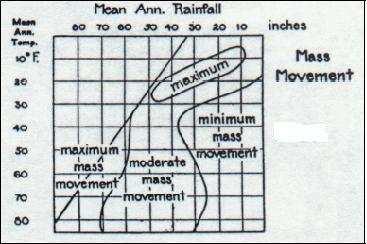
2 is especially effective at introducing chemically active agents by way of fractures and causing rocks to crumble piecemeal or by loosening thin shells of material (in spheroid weathering). Chemical weathering may include shallow, low-temperature alteration. The weathering process caused by cycles of freezing and thawing of water in surface pores, cracks, and other openings. Alternate or repeated cycles of freezing and thawing of water contained in materials; the term is especially applied to disruptive effects of this action. Frost action can also be termed as the mechanical weathering graph since it captures the areas where lack of high temperatures lend to more mechanical weathering than chemical weathering. The graph defines where there are significant amounts of precipitation and the freezing point is breeched often. This allows for freeze and refreeze, thus breaking down rock formations by mechanical means, i.e. rubbing, grinding and grating actions. The frost action graph takes into account the areas where the mean annual temperature and precipitation are causing this effect, thus causing the most mechanical weathering. The increasing temperature and increasing precipitation until the temperature is too high to allow for sufficient freeze thaw cycles to cause the mechanical weathering to take place define the other gradual regions. The weathering regions graph is a combination of the chemical weathering and frost action graphs. These two graphs when combined create the Weathering Regions since each is at the opposite spectrum of the Temperature means. Pluvial erosion is the amount of erosion that is caused by higher precipitation amounts over a given area. The regions of the pluvial erosion graph are perhaps the most confusing, since the areas with the greatest amount of precipitation and temperature are considered minimal compared to lower precipitation and temperature. Perhaps Peltier was taking into account the vegetation that occurs when you have high temperatures and large amounts of precipitation, namely tropical forests, which reduce pluvial erosion with all the plant matter and root systems. Peltier may have considered these areas as having as much or less pluvial erosion as areas where precipitation was very low on an annual basis. Mass movement is defined as areas where steep slopes and high annual precipitation cause the loosening and falling of large amounts of material. The graph is indicative of these areas of great amounts of rainfall and precipitation and also of lower temperatures, where the freeze thaw cycle has less of an effect, and of higher precipitation. Where the amount of precipitation is minimal, there is little mass movement occurring. Wind action is defined as areas where wind action, also considered mechanical weathering, by means of high wind speeds due to lack of precipitation or of high enough precipitation, and therefore a lack of vegetation to reduce wind speeds. The graph defines high annual temperature and precipitation as having less wind action due to high amounts of vegetation and moist soils, while low temperatures and areas with low precipitation are considered more vulnerable to wind action. Finally, the morphogenetic regions graph, which is more of a climatic and vegetative classification than a weathering graph, illustrates the various climate regimes that the temperature and precipitation annual means can describe. The actions of plants and the animals they support can have an effect on the weathering of any particular location to a lesser degree. The classifications for the Morphogenetic Regions are: Selva Wet and hot annually Maritime Wet and warm annually Moderate Less precipitation but still warm Savanna Lower amounts of precipitation but temperatures range from low to high annually Semi-arid Low precipitation amounts and warm to hot Arid Very little precipitation and hot Boreal Warm but cycles between freeze-thaw cycle and enough precipitation to nurture hardy vegetation Periglacial Freeze-thaw cycle is dominant and occurs often, and Glacial Freeze-thaw cycle less effective since temperatures stay very low year round. Shafiei et al. [6] studied weathering and geomechanical properties of Alvand granitic rocks in western Iran. From the field and laboratory studies, robust linear relationships are found between the weathering degree of the tested samples and their geomechanical properties. Maghsoodi et al. [3] studied the rock weathering process on the zoning of the North-West of Iran by Peltier s models. Results showed that from 9 of the morphogenetic zones of Peltier s model, 5 regions have occurred, so that the greater part is semi-arid zone in north west of Iran. Zamani (2009) in his doctoral thesis studied central Elborze morphogenetic of Iran by Peltier s method. Fowler and Peterson [1] represented Peltier s weathering, erosion and climatic graphs using Geographic Information Systems (GIS). 119
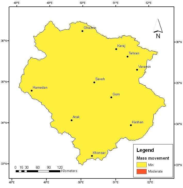
3 Khanlari et al. [2] evaluated weathering processes effect on engineering properties of Alvand granitic rocks (west of Iran), based on weathering indices. In this research was focused on the assessment of relationship between weathering indices and uniaxial compressive strength. For this reason, some of the most important weathering indices are reviewed. The aim of this study is determine of the rate and types of weathering and morphogenetic zones Namak lake basin using climatic data and Peltier s graph. MATERIALS AND METHODS The study area is located on longitude to E and latitude to N (Fig. 1). This zone includes the southern slopes of the central Elburz up to the northern slopes of the southern heights of Kashan and Karkas, and from the eastern slopes of Zagros to Dasht-e-kavir. The size of area under study equals km 2, km 2 (45.4%) of which is mountain and km 2 (54.6%) consist of plains and lakes. Altitude ranges from 800 m around Namak lake to 4375 m in the Jajrood heights (Fig. 2). In this domain, there are 3 large and some small playas, which absorb the surrounding water (Namak Lake, Hoze Sultan and Mighan Kavir). The average of annual rainfall varies from lower than 150 mm in the southeastern parts to more than 600 mm in the northern heights (Figure 3). The average of temperature varies 3-18 o C (Fig. 4). For this study first rain and temperature data of 32 synoptic stations from 1956 to 2005 were collected (Table 1) and import excel software. Then correlation between elevation and rain and temperature was calculated. By using topography maps was prepared digital elevation model (DEM) of basin in Arc-map. The rain and temperature of DEM cells calculated by above equations. The seven diagrams of Peltier was scanned in jpg format and reference based on rain and temperature. Total of DEM cells overlay on the graphs based on rain and temperature and then detected zones of cells. In order to use this information in Peltier seven models, the unit of temperature and precipitation changed from Celsius to Fahrenheit and from millimeters to inches. RESULTS AND DISCUSSION The temperature gradient in relation to the height is: T = H (1) Where, T; is the average temperature of the point H (m above sea level). By Equation 1 and the DEM map a temperature map can now be prepared. The relation between rain and height is: P = H (2) The rain map of the basin can now be drawn by Equation 2. Rain and temperature of total cells of DEM map calculated by above equations. Then point map prepared with X and Y coordinates equal rain and temperature. Overlay this map on the seven Peltier's graphs showed condition of total cells. By this method seven maps were drawn in the name of: chemical weathering, frost action, weathering regions, pluvial erosion, mass movement, wind action and morphogenetic regions (Fig. 5). Namak lake basin climate from east to west and from south to north and north-west change from hot to cold and from dry to wet. Elevation factor plays the major role in this change. Due to low average rainfall and high temperatures in the basin water balance is negative. Qualitative and quantitative water scarcity and reduce the plant cover has increased erosion by wind and water. Different faces of deep drainages, ditches and sand dunes at wider deployment are proof of the high water and wind erosion. Low humidity in the basin has reduced the mass movement and chemical weathering. Since the weathering rate is sum of chemical weathering and mechanical, weathering rates are low. In totally, basin due to climate conditions, most of the semi-arid and arid regions respectively morphogenetic zones basin belongs. Zones observed in basin include: maximum and moderate in wind action, very slight and slight mechanical in weathering, weak in chemical weathering, absent and weak in frost action, minimum and moderate in mass movement, maximum, minimum and moderate in pluvial erosion and arid, semiarid, savanna and boreal in morphogenetic regions. 120


4 Fig. 1: Basin of Namak lake Fig. 2: Hypsometry map of Namak lake basin 121


5 Fig. 3: Rain map of Namak lake basin Fig. 4: Temperature map of Namak lake basin Fig. 5: The Wind action map results from the processing of Peltier s graph 122


6 Table 1. Synoptic stations of Namak lake basin Fig. 6: The weathering regions map results from the processing of Peltier s graph 123


7 Fig. 7: The chemical weathering map results from the processing of Peltier s graph Fig. 8: The frost action map results from the processing of Peltier s graph Fig. 9: The mass movement map results from the processing of Peltier s graph 124


![[2] Khanlari G.R., Heidari M., Momeni A.](/docs-images/76/74082542/images/8-2.jpg "A., Environ Earth Sci, 2012, 67, 713-725. [3] Maghsodi M., Khoshakhlagh F.")
![, Hanafi A., Rosta I., Geo Res, 2010, 74, 35-46. [4] Once H., Ph.](/docs-images/76/74082542/images/8-3.jpg "D Thesis, 2009, pp 243. [5] Peltier C., Louis C.")
8 Fig. 10: The pluvial erosion map results from the processing of Peltier s graph Fig. 11: The morphogenetic regions map results from the processing of Peltier s graph REFERENCES [1] Fowler R., Petersen J., Adv GIS II, 2003, GEO5419. [2] Khanlari G.R., Heidari M., Momeni A.A., Environ Earth Sci, 2012, 67, [3] Maghsodi M., Khoshakhlagh F., Hanafi A., Rosta I., Geo Res, 2010, 74, [4] Once H., Ph.D Thesis, 2009, pp 243. [5] Peltier C., Louis C., Ann Assoc Amer Geo, 1950, 40, [6] Shafiei A., Heidari M., Dusseault M.B., 1 st Canada-US Rock Mechanics Sym, 2007,
Mechanical Weathering
 Weathering is the disintegration and decomposition of material at or near the surface. Erosion is the incorporation and transportation of material by a mobile agent, usually water, wind, or ice. Geologists
Ecoregions Glossary. 7.8B: Changes To Texas Land Earth and Space
 Ecoregions Glossary Ecoregions The term ecoregions was developed by combining the terms ecology and region. Ecology is the study of the interrelationship of organisms and their environments. The term,
Glaciers. 1. The photograph below shows the results of a landslide.
 Name: Date: 1. The photograph below shows the results of a landslide. This landslide is an example of A) wind abrasion B) glacial deposition C) wave action D) mass movement 2. Which agent of erosion is
Weathering, Erosion, Deposition, and Landscape Development
 Weathering, Erosion, Deposition, and Landscape Development I. Weathering - the breakdown of rocks into smaller particles, also called sediments, by natural processes. Weathering is further divided into
How does Rock become Exposed to the Surface?
 Weathering How does Rock become Exposed to the Surface? Most rocks, like granite, form under earth s surface. The rocks uplift and eventually make their way to earth s surface. Conditions on the surface
Earth: An Introduction to Physical Geology Weathering and Soil
 Chapter 6 Lecture Earth: An Introduction to Physical Geology Eleventh Edition Weathering and Soil Tarbuck and Lutgens Weathering Weathering involves the physical breakdown and chemical alteration of rock
Topic 6: Weathering, Erosion and Erosional-Deposition Systems (workbook p ) Workbook Chapter 4, 5 WEATHERING
 Workbook Chapter 4, 5 WEATHERING") Topic 6: Weathering, Erosion and Erosional-Deposition Systems (workbook p. 95-125) Workbook Chapter 4, 5 THE BIG PICTURE: Weathering, erosion and deposition are processes that cause changes to rock material
Topic 6: Weathering, Erosion and Erosional-Deposition Systems (workbook p. 95-125) Workbook Chapter 4, 5 THE BIG PICTURE: Weathering, erosion and deposition are processes that cause changes to rock material
Surface Processes on the Earth. Rocks, Weathering, Erosion and Soil
 Surface Processes on the Earth Rocks, Weathering, Erosion and Soil ROCKS AND ROCK CYCLE Rock types Three main types of rock Igneous Metamorphic Sedimentary Igneous Form when magma or lava cools and hardens
Soil Formation. Lesson Plan: NRES B2-4
 Soil Formation Lesson Plan: NRES B2-4 1 Anticipated Problems 1. What are five different factors that affect soil formation? 2. What are some different types of parent material that affect soils? 3. What
Bill Nye: Rocks and Soil
 Bell Ringer 1.What kind of rock is formed by applying heat and pressure to existing rock? 2.What would be required to turn a sedimentary rock into an igneous rock? 3.How are sedimentary rocks classified?
Introduction to Weathering
 Name: Date: Period: Unit 9: Earth s Destructive Forces A. Kinds of Weathering Introduction to Weathering Distinguish between two major processes that change the Earth surface. Identify two types of weathering.
What factors affect the angle of a slope?
 Climate Rock type and Structure What factors affect the angle of a slope? Aspect Fast mass movements Slides: Slides are movements along the SLIP PLANE, i.e. a line of weakness in the rock or soil structure.
Chapter 6. Weathering, Erosion, and Soil
 Chapter 6 Weathering, Erosion, and Soil Introduction Rocks and minerals disintegrate and decompose by the processes of physical and chemical weathering. This breakdown occurs because the parent material
Weathering, Soil, & Mass Movements. Chapter 5
 Weathering, Soil, & Mass Movements Chapter 5 5.1 Weathering Weathering: the breaking down and changing of rocks at or near the Earth s surface. Basic part of the rock cycle. 2 main types: 1. Mechanical
Earth systems the big idea guiding questions Chapter 1 & 2 Earth and Earth Systems review notes are in purple
 Earth systems the big idea guiding questions Chapter 1 & 2 Earth and Earth Systems review notes are in purple How can you describe Earth? What are the composition and the structure of the atmosphere? How
3. The map below shows an eastern portion of North America. Points A and B represent locations on the eastern shoreline.
 1. Most tornadoes in the Northern Hemisphere are best described as violently rotating columns of air surrounded by A) clockwise surface winds moving toward the columns B) clockwise surface winds moving
Unit E: Basic Principles of Soil Science. Lesson 2: Understanding Soil Formation
 Unit E: Basic Principles of Soil Science Lesson 2: Understanding Soil Formation Important Terms Alluvium Bedrock Chemical weathering Climate Glacial till Loess Native vegetation Organic matter Outwash
Wearing Down Landforms
 Wearing Down Landforms Denudation Denudation has also been called gradation. It is the Natural loss of soil and rock debris, blown away by wind or washed away by running water, laying bare the rock below.
Unit 3 Study Guide -- Greenberg science, 6C
 Unit 3 Study Guide -- Greenberg science, 6C Name Pd. Date / / 2018 + +5 extra credit points on the test if submitted complete and correct ON THE TEST DATE. + A copy can be found on my website mgreenberg.weebly.com
Page 1. Weathering & Erosion by Mass Wasting Pre-Test. Name:
 Weathering & Erosion by Mass Wasting Pre-Test 3048-1 - Page 1 Name: 1) As a particle of sediment in a stream breaks into several smaller pieces, the rate of weathering of the sediment will A) increase
Tropical Moist Rainforest
 Tropical or Lowlatitude Climates: Controlled by equatorial tropical air masses Tropical Moist Rainforest Rainfall is heavy in all months - more than 250 cm. (100 in.). Common temperatures of 27 C (80 F)
EVALUATING THE EFFECTS OF CLIMATE ON WEATHERING PELTIER MODELS IN KERMANSHAHH PROVINCE. University, Tehran, Iran. Published online: 17 June 2016
 Journal of Fundamental and Applied Sciences Research Article ISSN 1112-9867 Available online at http://www.jfas.info EVALUATING THE EFFECTS OF CLIMATE ON WEATHERING PROCESSES OF ROCKS BASED ON PELTIER
Essentials of Geology, 11e
 Essentials of Geology, 11e and s Chapter 5 Instructor Jennifer Barson Spokane Falls Community College Geology 101 Stanley Hatfield Southwestern Illinois College Jennifer Cole Northeastern University Earth
Energy Systems, Structures and Processes Essential Standard: Analyze patterns of global climate change over time Learning Objective: Differentiate
 Energy Systems, Structures and Processes Essential Standard: Analyze patterns of global climate change over time Learning Objective: Differentiate between weather and climate Global Climate Focus Question
A Spatial Representation of Louis Peltier s Weathering, Erosion and Climatic Graphs Using Geographic Information Systems (GIS)
") Title A Spatial Representation of Louis Peltier s Weathering, Erosion and Climatic Graphs Using Geographic Information Systems (GIS) Authors Rell Fowler, BS Geography, Master of Applied Geography Dr. James
Title A Spatial Representation of Louis Peltier s Weathering, Erosion and Climatic Graphs Using Geographic Information Systems (GIS) Authors Rell Fowler, BS Geography, Master of Applied Geography Dr. James
Which map shows the stream drainage pattern that most likely formed on the surface of this volcano? A) B)
 B)") 1. When snow cover on the land melts, the water will most likely become surface runoff if the land surface is A) frozen B) porous C) grass covered D) unconsolidated gravel Base your answers to questions
1. When snow cover on the land melts, the water will most likely become surface runoff if the land surface is A) frozen B) porous C) grass covered D) unconsolidated gravel Base your answers to questions
Social Studies. Chapter 2 Canada s Physical Landscape
 Social Studies Chapter 2 Canada s Physical Landscape Introduction Canada s geography its landforms and climate - has a great impact on Canadians sense of identity. Planet Earth The earth is divided into
Desertification Hazard Zonation by Means of ICD Method in Kouhdasht Watershed
 DESERT DESERT Online at http://jdesert.ut.ac.ir DESERT 17 (13) 233240 Desertification Hazard Zonation by Means of ICD Method in Kouhdasht Watershed Gh. Chamanpira a*, Gh.R. Zehtabian b, H. Ahmadi c, M.
Which process is represented by letter F? A) capillarity B) infiltration C) condensation D) vaporization
 capillarity B) infiltration C) condensation D) vaporization") 1. Water's covalent bond is due to A) water's ability to stick to stick to other materials B) a slight negative charge of O and positive charge of H C) an uneven sharing of electrons D) both B and C 2.
1. Water's covalent bond is due to A) water's ability to stick to stick to other materials B) a slight negative charge of O and positive charge of H C) an uneven sharing of electrons D) both B and C 2.
Rocks and Weathering
 Rocks and Weathering The Effects of Weathering The process of mountain building thrusts rock up to Earth s surface. Weathering is the process that breaks down rock and other substances at Earth s surface.
2011 Pearson Education, Inc.
 Weathering and Soil Earth - Chapter 6 Earth s External Processes Weathering the physical breakdown and chemical decomposition of rock Mass wasting the transfer of rock and soil downslope under the influence
2011 Pearson Education, Inc.
 Weathering and Soil Earth - Chapter 6 Earth s External Processes Weathering the physical breakdown and chemical decomposition of rock Mass wasting the transfer of rock and soil downslope under the influence
Weathering is the process that breaks down rock and other substances at Earth s surface
 Chapter 8 Notes Weathering is the process that breaks down rock and other substances at Earth s surface Factors that contribute to weathering Heat Cold Water Ice O 2 & CO 2 in the atmosphere Examples of
EARTH S CHANGING SURFACE
 EARTH S CHANGING SURFACE Weathering Together, weathering and erosion work continuously to wear down the material on Earth s surface. weathering process that breaks down rock and other substances of Earth
Chapter 5: Weathering and Soils. Fig. 5.14
 Chapter 5: Weathering and Soils Fig. 5.14 OBJECTIVES Recognize that weathering breaks down minerals and rocks and occurs as a result of both mechanical and chemical processes. Explain the processes that
Weathering, Erosion, Deposition
 Weathering, Erosion, Deposition The breakdown of rocks at or near the Earth s Surface. Physical Chemical - The breakdown of rock into smaller pieces without chemical change. - Dominant in moist /cold conditions
UNIT SEVEN: Earth s Water. Chapter 21 Water and Solutions. Chapter 22 Water Systems. Chapter 23 How Water Shapes the Land
 UNIT SEVEN: Earth s Water Chapter 21 Water and Solutions Chapter 22 Water Systems Chapter 23 How Water Shapes the Land Chapter Twenty-Three: How Water Shapes the Land 23.1 Weathering and Erosion 23.2
Monday, Oct Field trip A1 & A2 signups: make sure you are where you think you should be
 Monday, Oct. 4 1. Field trip A1 & A2 signups: make sure you are where you think you should be 2. 5 credit people, field trip introduction in lab today 1. If you are unable to attend THIS SATURDAY, let
Chapter 6 9/25/2012. Weathering, Erosion and Soils. Introduction. How Are Earth Materials Altered? Introduction. How Are Earth Materials Altered?
 Chapter 6 Introduction Rocks and minerals are disintegrated and decomposed by the processes of mechanical and chemical weathering. Weathering, Erosion and Soils This breakdown occurs because the parent
Page 1. Name:
 Name: 1) As the difference between the dewpoint temperature and the air temperature decreases, the probability of precipitation increases remains the same decreases 2) Which statement best explains why
Chapter: Weathering and Erosion
 Chapter: Weathering and Erosion Section 1: Weathering and Soil Formation Minerals form rocks Rocks form soil Weathering Weathering is a mechanical or chemical surface process that breaks rocks into smaller
Figure 1 The map shows the top view of a meandering stream as it enters a lake. At which points along the stream are erosion and deposition dominant?
 1. In which type of climate does chemical weathering usually occur most rapidly? 1. hot and dry 3. cold and dry 2. hot and wet 4. cold and wet 2. Figure 1 The map shows the top view of a meandering stream
Section 7.1. Weathering. SES3a. Objectives
 SES3a. Objectives Distinguish between mechanical and chemical weathering. Describe the different factors that affect mechanical and chemical weathering. Identify variables that affect the rate of weathering.
Wednesday, October 10 th
 Wednesday, October 10 th Page 13a (left side) / Place Lab on table Objective: We will describe the different types of weathering and erosion and identify evidence of each type. Warm-up: 1. What is weathering?
Weathering and Erosion
 Weathering and Erosion OBJECTIVE: Explain how erosion and deposition shape Earth s surface by matching and using models How do erosion and deposition shape Earth s surface? Deposition Formation Transported
Weathering Erosion and Deposition. Presented by Kesler Science
 Weathering Erosion and Deposition Presented by Kesler Science Essential Questions: 1. What effects do weathering, erosion, and deposition have on the environment in ecoregions? Weathering Chemical and
GLOBAL CLIMATES FOCUS
 which you will learn more about in Chapter 6. Refer to the climate map and chart on pages 28-29 as you read the rest of this chapter. FOCUS GLOBAL CLIMATES What are the major influences on climate? Where
Practice Questions for Lecture 5 Geology 1200
 Practice Questions for Lecture 5 Geology 1200 Use these questions to test your knowledge of Lecture5. The exams will be similar in format, except that they will deal with more than one chapter, and will
Biosphere. All living things, plants, animals, (even you!) are part of the zone of the earth called the biosphere.
 are part of the zone of the earth called the biosphere.") Unit 1 Study Guide Earth s Spheres Biosphere All living things, plants, animals, (even you!) are part of the zone of the earth called the biosphere. Hydrosphere Water covers ¾ of the earth, made up mostly
Unit 1 Study Guide Earth s Spheres Biosphere All living things, plants, animals, (even you!) are part of the zone of the earth called the biosphere. Hydrosphere Water covers ¾ of the earth, made up mostly
Unit 4: Landscapes Practice Problems
 Name: Date: 1. Soil with the greatest porosity has particles that are A. poorly sorted and densely packed B. poorly sorted and loosely packed C. well sorted and densely packed D. well sorted and loosely
Unit 7.2 W.E.D. & Topography Test
 Name: Score: Unit 7.2 W.E.D. & Topography Test 1. 2. 3. 4. 5. 6. 7. 8. 9. 10. 11. 12. 13. 14. 15. 16. 17. 18. 19. 20. 21. 22. 23. 24. 25. 1. The formation of mountains is due mainly to while the destruction
Grade 9 Social Studies Canadian Identity. Chapter 2 Review Canada s Physical Landscape
 Grade 9 Social Studies Canadian Identity Chapter 2 Review Canada s Physical Landscape Name: Unit 1: Empowerment Terms (notes or textbook) 1. Core 2. Crust 3. Mantle 4. Magma 5. Continental drift 6. Plate
The physical breakdown and chemical alteration of rocks and minerals at or near Earth s surface.
 The physical breakdown and chemical alteration of rocks and minerals at or near Earth s surface. The material that is chemically and mechanically weathered to yield sediment and soil. Regolith consisting
Physical Geology, 15/e
 Lecture Outlines Physical Geology, 15/e Plummer, Carlson & Hammersley Weathering and Soil Physical Geology 15/e, Chapter 5 Weathering, Erosion and Transportation Rocks exposed at Earth s surface are constantly
Preliminaries to Erosion: Weathering and Mass Wasting
 Preliminaries to Erosion: Weathering & Mass Wasting All things deteriorate in time. Virgil 1 Preliminaries to Erosion: Weathering and Mass Wasting Denudation The Impact of Weathering and Mass Wasting on
Mechanical Weathering
 Mechanical Weathering Objectives Students will be able to: Explain how weathering breaks down rock. Explain how a rock s surface area affects the rate of weathering. The Great Sphinx Of all the amazing
Objectives. Introduction to Soils. Terms to know: What is soil? Study of Soils. The Soil Body 11/9/2012
 Objectives Explain what soil is and where it comes from Define a soil body List examples of the five soil-forming factors Explain how soils develop Introduction to Soils Terms to know: What is soil? Alluvial
Synoptic Analysis of Total Rainfall Patterns at Azerbaijan District.
 Synoptic Analysis of Total Rainfall Patterns at Azerbaijan District Samad Vahdati 1, Shahrokh Shahrokhi Shirvani 2, Abolfazl Nazari Giglou 3 1,3 Department of Civil Engineering, Parsabad Moghan Branch,
Exploring Geography. Chapter 1
 Exploring Geography Chapter 1 The Study of Geography Geography is the study of where people, places, and things are located and how they relate to each other. Greek meaning writing about or describing
Unit 3 Review - Surface Processes
 Unit 3 Review - Surface Processes 1. Why is the surface of Mercury covered with meteor impact craters, while Earth s surface has relatively few craters? A) Mercury is larger than Earth, so it gets hit
Weathering and Soil Formation. Chapter 10
 Weathering and Soil Formation Chapter 10 Old and New Mountains The Appalachian Mountains appear very different from the Sierra Mountains. The Appalachians are smaller, rounded, gently sloping, and covered
Limestone dissolved by naturally acidic rainwater. Weathering and Soils Lecture 5
 Last time Viscosity determines the ability of a melt to releases gasses coming out of solution Viscosity depends on silica content and TEMPERATURE Mafic (Basaltic) melts are extremely hot and have low
THE CHANGING SURFACE OF THE EARTH
 THE CHANGING SURFACE OF THE EARTH Key words Drain geological agent weathering erosion Sediment deposition transport The landscape is a consequence of the action of two types of geological processes; internal
Anticipation Guide #4 Ice wedging is a form of chemical weathering Erosion is the process where rocks are broken down The most active erosion agent
 Weathering Anticipation Guide #4 Ice wedging is a form of chemical weathering Erosion is the process where rocks are broken down The most active erosion agent on the planet is running water Gravity plays
Physical Geography A Living Planet
 Physical Geography A Living Planet The geography and structure of the earth are continually being changed by internal forces, like plate tectonics, and external forces, like the weather. Iguaçu Falls at
World Geography Chapter 3
 World Geography Chapter 3 Section 1 A. Introduction a. Weather b. Climate c. Both weather and climate are influenced by i. direct sunlight. ii. iii. iv. the features of the earth s surface. B. The Greenhouse
Name: Regents Earth Science. Weather and Climate - Review Questions
 Name: Regents Earth Science Weather and Climate - Review Questions Date: Thayer - 279 1. People sometimes release substances into the atmosphere to increase the probability of rain by A) raising the air
Climate Chapter 19. Earth Science, 10e. Stan Hatfield and Ken Pinzke Southwestern Illinois College
 Climate Chapter 19 Earth Science, 10e Stan Hatfield and Ken Pinzke Southwestern Illinois College The climate system A. Climate is an aggregate of weather B. Involves the exchanges of energy and moisture
Weathering, Soil, and Mass Movements
 Tarbuck Lutgens Weathering, Soil, and Mass Movements 5.1 Weathering Mechanical Weathering Mechanical weathering occurs when physical forces break rock into smaller and smaller pieces without changing the
Climate and the Atmosphere
 Climate and Biomes Climate Objectives: Understand how weather is affected by: 1. Variations in the amount of incoming solar radiation 2. The earth s annual path around the sun 3. The earth s daily rotation
Pratice Surface Processes Test
 1. The cross section below shows the movement of wind-driven sand particles that strike a partly exposed basalt cobble located at the surface of a windy desert. Which cross section best represents the
Chapter 2: Physical Geography
 Chapter 2: Physical Geography Pg. 39-68 Learning Goals for Chp2: q q q q q Explain how the Earth moves in space and why seasons change. Outline the factors that influence climate and recognize different
Module 11: Meteorology Topic 3 Content: Climate Zones Notes
 Introduction Latitude is such an important climate factor that you can make generalizations about a location's climate based on its latitude. Areas near the equator or the low latitudes are generally hot
Climates of Earth. Lesson Outline LESSON 1. A. What is climate? 1. is the long-term average weather conditions that occur in a particular region.
 Lesson Outline LESSON 1 A. What is climate? 1. is the long-term average weather conditions that occur in a particular region. 2. Climate depends on how average weather conditions throughout the year. B.
Name: Period: Date: ID: A. Circle the choice that best completes the statement or answers the question and write the letter on the blank.
 Name: Period: _ Date: _ ID: A Unit 7 Practice Circle the choice that best completes the statement or answers the question and write the letter on the blank. 1. What term describes the movement of rock
CLIMATE. UNIT TWO March 2019
 CLIMATE UNIT TWO March 2019 OUTCOME 9.2.1Demonstrate an understanding of the basic features of Canada s landscape and climate. identify and locate major climatic regions of Canada explain the characteristics
Sediment and Sedimentary rock
 Sediment and Sedimentary rock Sediment: An accumulation of loose mineral grains, such as boulders, pebbles, sand, silt or mud, which are not cemented together. Mechanical and chemical weathering produces
Monument Valley, Utah. What weathering processes contributed to the development of these remarkable rock formations? Weathering Mechanisms
 Monument Valley, Utah. What weathering processes contributed to the development of these remarkable rock formations? Weathering Includes Physical, Chemical, Biological processes WEATHERING CHAPTER 7 Weathering
WHAT CAN MAPS TELL US ABOUT THE GEOGRAPHY OF ANCIENT GREECE? MAP TYPE 1: CLIMATE MAPS
 WHAT CAN MAPS TELL US ABOUT THE GEOGRAPHY OF ANCIENT GREECE? MAP TYPE 1: CLIMATE MAPS MAP TYPE 2: PHYSICAL AND/OR TOPOGRAPHICAL MAPS MAP TYPE 3: POLITICAL MAPS TYPE 4: RESOURCE & TRADE MAPS Descriptions
Weathering: the disintegration, or breakdown of rock material
 Weathering: the disintegration, or breakdown of rock material Mechanical Weathering: no change in chemical composition--just disintegration into smaller pieces Chemical Weathering: breakdown as a result
Earth and Space Science. Semester 2 Review, Part 2
 Earth and Space Science Semester 2 Review, Part 2 2015 Chemical Weathering -The process that breaks down rock through chemical changes. Examples that cause chemical weathering include the action of water
Weathering is the process by which rocks on or near Earth s surface break down and change. Spherical weathering near Paris, NC
 Weathering Weathering is the process by which rocks on or near Earth s surface break down and change. Spherical weathering near Paris, NC The two types of weathering are Chemical and. Mechanical Mechanical
Chapter 1 Section 2. Land, Water, and Climate
 Chapter 1 Section 2 Land, Water, and Climate Vocabulary 1. Landforms- natural features of the Earth s land surface 2. Elevation- height above sea level 3. Relief- changes in height 4. Core- most inner
LECTURE #14: Extreme Heat & Desertification
 GEOL 0820 Ramsey Natural Disasters Spring, 2018 LECTURE #14: Extreme Heat & Desertification Date: 27 February 2018 (lecturer: Dr. Shawn Wright) I. Start of Part 2 of the Course weather-related disasters
The Earth, the sun, the planets and the twinkling stars in the sky are all part of a galaxy, or family of stars. We call our galaxy the Milky Way
 Part One The Earth, the sun, the planets and the twinkling stars in the sky are all part of a galaxy, or family of stars. We call our galaxy the Milky Way because the lights from its billions of stars
Biosphere Organization
 Biosphere Organization What is a biome? Biomes refer to a large region or area characterized by the following: 1. A particular climate pattern of the annual temperature and precipitation distribution,
Science and Health EFFECT OF EROSION ON THE CONDITION OF SOIL AND LAND SHAPE
 4 Module 51 Science and Health EFFECT OF EROSION ON THE CONDITION OF SOIL AND LAND SHAPE A DepEd-BEAM Distance Learning Program supported by the Australian Agency for International Development To the Learner
every continent has an extensive dry region! " deserts are as much as 1/3 of Earth s surface!
 deserts! deserts! every continent has an extensive dry region! " deserts are as much as 1/3 of Earth s surface! Hollywood portrayal of vast stretches of sand dune! " Sahara has only 10% covered by sand!
Weathering, Erosion and Deposition
 Weathering, Erosion and Deposition Shaping the Earth s Surface Weathering the process of breaking down rocks into smaller fragments Erosion the transport of rock fragments from one location to another
Introduction to Soil Mechanics Geotechnical Engineering-II
 Introduction to Soil Mechanics Geotechnical Engineering-II ground SIVA Dr. Attaullah Shah 1 Soil Formation Soil derives from Latin word Solum having same meanings as our modern world. From Geologist point
- Take a notes packet from trapezoid table. - Start vocab on notes packet
 - Take a notes packet from trapezoid table. - Start vocab on notes packet Objectives: You will learn about weathering and its effects. You will learn to explain what mechanical weathering is and how it
Earth Science S5E1b (EarthScienceS5E1b)
") Name: Date: 1. The flattest part of the ocean floor is the A. trench. B. abyssal plain. C. continental shelf. D. mid-ocean rift valley. 2. Which causes some parts of the ocean to be saltier than other
Name: Date: 1. The flattest part of the ocean floor is the A. trench. B. abyssal plain. C. continental shelf. D. mid-ocean rift valley. 2. Which causes some parts of the ocean to be saltier than other
Weathering of Rocks. Weathering - Breakdown of rocks into pieces (sediment) 2 main types of weathering to rocks
 2 main types of weathering to rocks") Weathering of Rocks Weathering - Breakdown of rocks into pieces (sediment) 2 main types of weathering to rocks Mechanical weathering requires physical forces to break rocks into smaller pieces. Chemical
Weathering of Rocks Weathering - Breakdown of rocks into pieces (sediment) 2 main types of weathering to rocks Mechanical weathering requires physical forces to break rocks into smaller pieces. Chemical
Our climate system is based on the location of hot and cold air mass regions and the atmospheric circulation created by trade winds and westerlies.
 CLIMATE REGIONS Have you ever wondered why one area of the world is a desert, another a grassland, and another a rainforest? Or have you wondered why are there different types of forests and deserts with
Chapter 5: Weathering and soils! Monument Valley, Utah!
 Chapter 5: Weathering and soils! Monument Valley, Utah! weathering, erosion, and transportation! rocks on Earth s surface are constantly changed by "water, air, temperature changes and other factors! weathering
Understanding Earth Fifth Edition
 Understanding Earth Fifth Edition Grotzinger Jordan Press Siever Chapter 16: WEATHERING, EROSION, AND MASS WASTING Interface Between Climate and Tectonics Lecturer: H Mohammadzadeh Assistant professors,
1. Any process that causes rock to crack or break into pieces is called physical weathering. Initial product = final product
 Weathering 1. Any process that causes rock to crack or break into pieces is called physical weathering. Initial product = final product End Result of physical weathering is increased surface area. 2. Physical
EARTH SCIENCE KESSEL
 EARTH SCIENCE KESSEL Bell Ringer Explain the concept of matter.? s to answer that might help you in your explanation: 1. What is it? 2. What is it made of? 3. Does it have a shape? 4. How would you know
Climate and Biomes. Adapted by T.Brunetto from: Developed by Steven Taylor Wichmanowski based in part on Pearson Environmental Science by Jay Withgott
 Climate and Biomes Adapted by T.Brunetto from: Developed by Steven Taylor Wichmanowski based in part on Pearson Environmental Science by Jay Withgott Remember that an ecosystem consists of all the biotic
Climate. Annual Temperature (Last 30 Years) January Temperature. July Temperature. Average Precipitation (Last 30 Years)
 January Temperature. July Temperature. Average Precipitation (Last 30 Years)") Climate Annual Temperature (Last 30 Years) Average Annual High Temp. (F)70, (C)21 Average Annual Low Temp. (F)43, (C)6 January Temperature Average January High Temp. (F)48, (C)9 Average January Low Temp.
Climate Annual Temperature (Last 30 Years) Average Annual High Temp. (F)70, (C)21 Average Annual Low Temp. (F)43, (C)6 January Temperature Average January High Temp. (F)48, (C)9 Average January Low Temp.