Attabad landslide crisis in Hunza, Pakistan lessons for the management of valley blocking landslides. Dave Petley
|
|
|
- Charles Jefferson
- 6 years ago
- Views:
Transcription


1 Attabad landslide crisis in Hunza, Pakistan lessons for the management of valley blocking landslides Dave Petley Durham University, United Kingdom Thanks to: D. Karim, S. Wali, N. Ali, N. Nasab & K. Shaban Focus Humanitarian Assistance, Pakistan
2 Schedule of talk Global landslide mortality hazard and risk Landslide mortality hazard and risk along the Himalayan Arc The 2010 Attabad landslide, Hunza, Pakistan Powerpoint file on my AGU hosted blog at: Google: landslide blog AGU
3 CRED data for landslide fatalities Cumulative number of fatalities Year Other disasters (CRED database) Earthquake: 429,877 River flood: 37,860 Storm: 166,410 Volcano: 221
4 The (more) true human cost of landslides ,833 Cumulative number of fatalities Landslides from the Wenchuan earthquake Landslides from the Kashmir earthquake Date

5 Global fatal rainfall-induced landslides 2006 to 2009
6 Himalayan Arc


7 Himalayan Arc 2004 to 2009
8 Daily average number of NFLs Monthly occurrence of non-seismic fatal landslides (NFLs) Average
9 Annual cycle in pentads (five day bins) 25 Number of recorded landslides Day number
10 Trend in occurrence? Fatalities R² = Number of fatalities R² = Landslides Number of NFLs

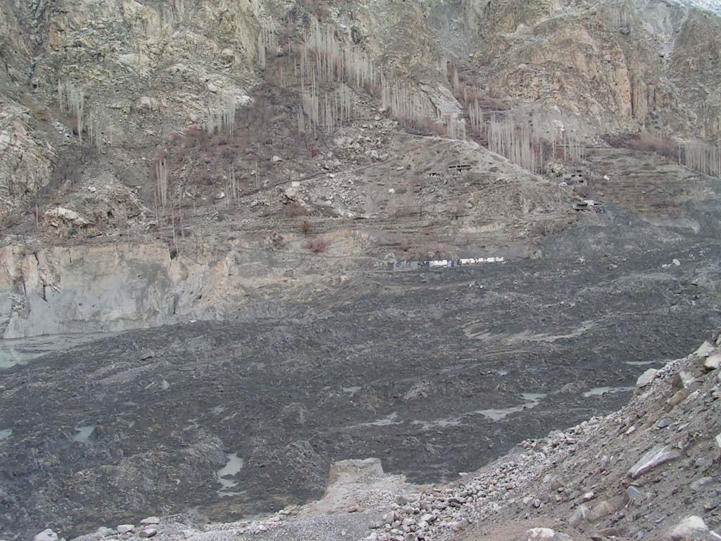
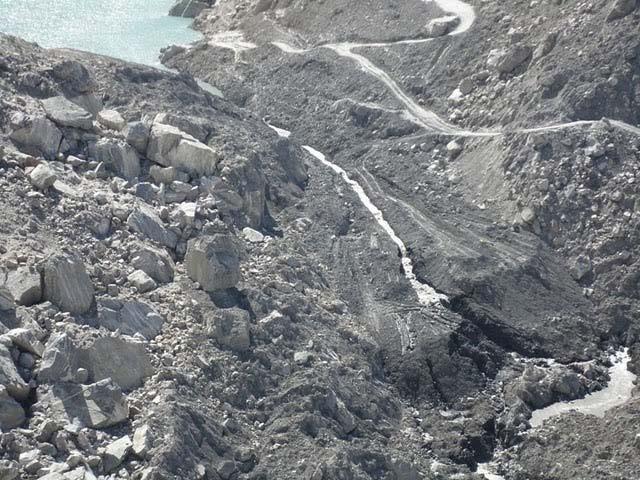
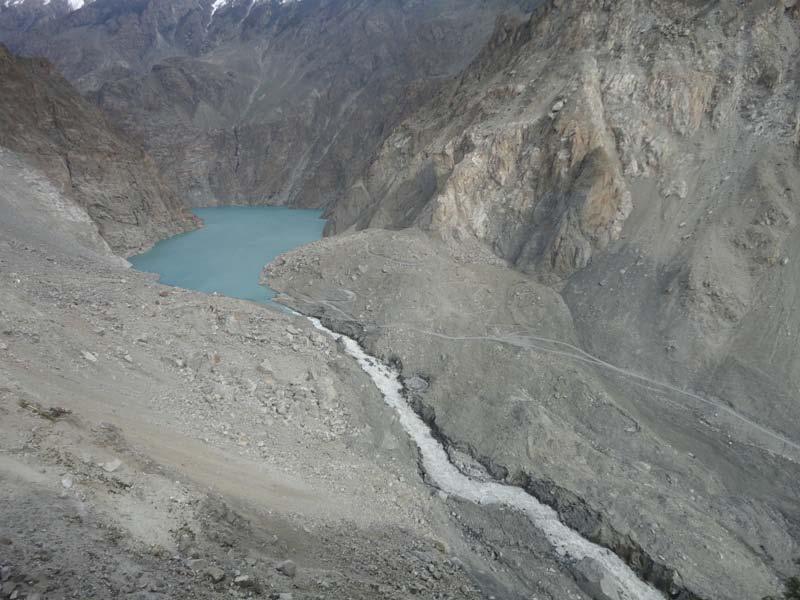
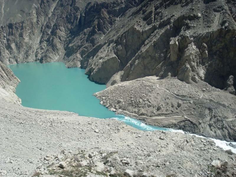
11 Attabad

12
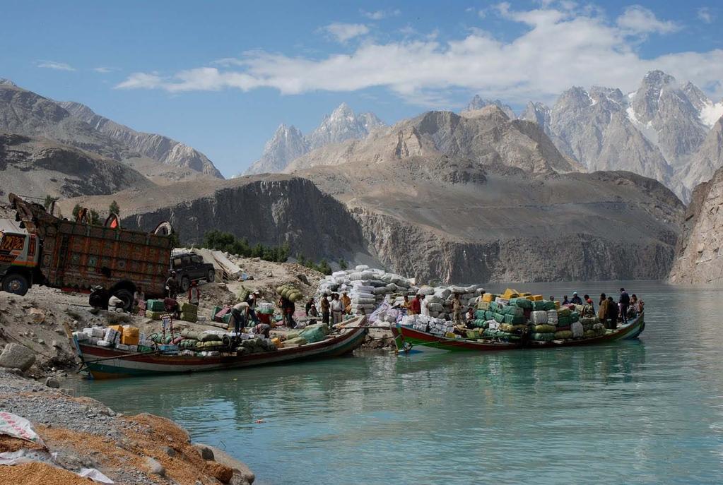
13

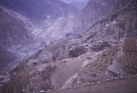
14 Slope identified as unstable in 2003

15 Collapse event: 4 th January 2010
16

17 1. Progressive failure over >7 years, scar height = 1175 m 2. Catastrophic failure event in Jan 2010 with no trigger Cross valley runout = 1300 m Deposit height = 120 to 200 m 3. Emplacement of rockslide onto lake sediments triggered secondary high velocity mudflow event
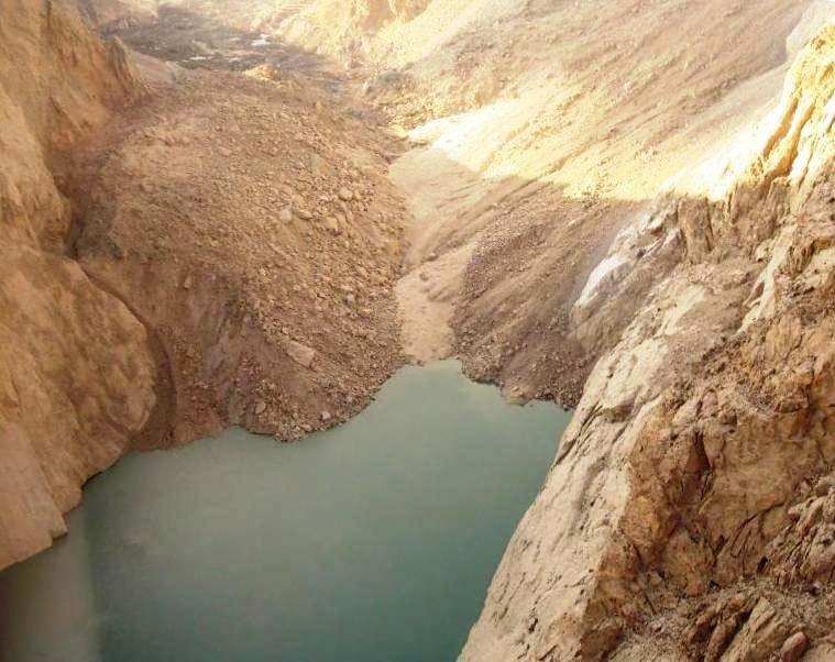
18

19


20 1858 landslide dam
21 Wenchuan Earthquake barrier lake risk table Yang et al 2010
22 Data driven flood estimation Typical values of maximum discharge using this approach: 14,000 cumecs (Costa and Schuster 1986) 12,000-26,000 cumecs (Walder and O Connor 1997)

23 Management of the hazard Initial management response was the construction of a spillway. Original intention: 30 metres deep Actual depth at time of overtopping: 15 metres Final spillway was very narrow and unlined

24 Evacuations After the landslide, Focus installed sirens in 15 villages People in most hazardous areas relocated into camps Boat service established on lake, but enormous hardship upstream One month before overtopping NDMA evacuated 15,000 people downstream of barrier

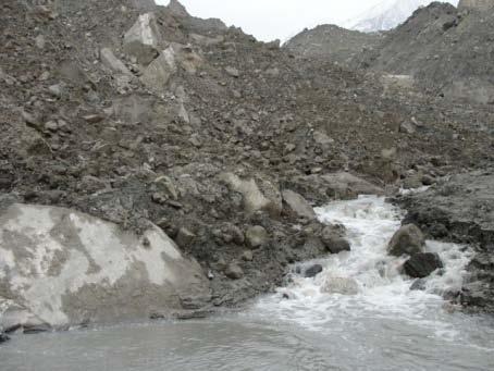
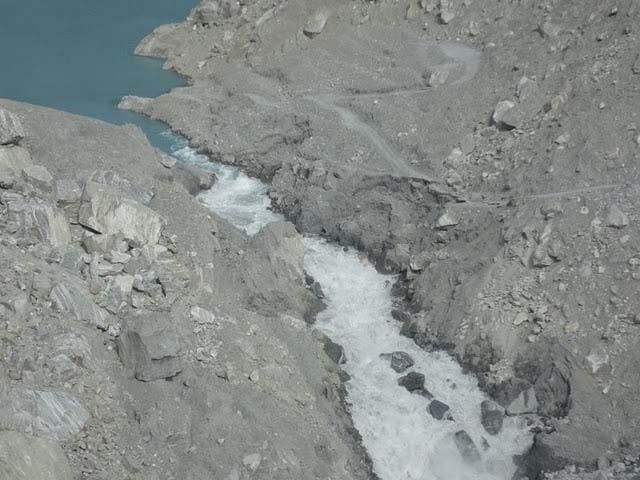
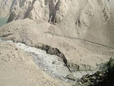
25 Seepage
26 Volume of seepage (cubic metres per second) Seepage development Date
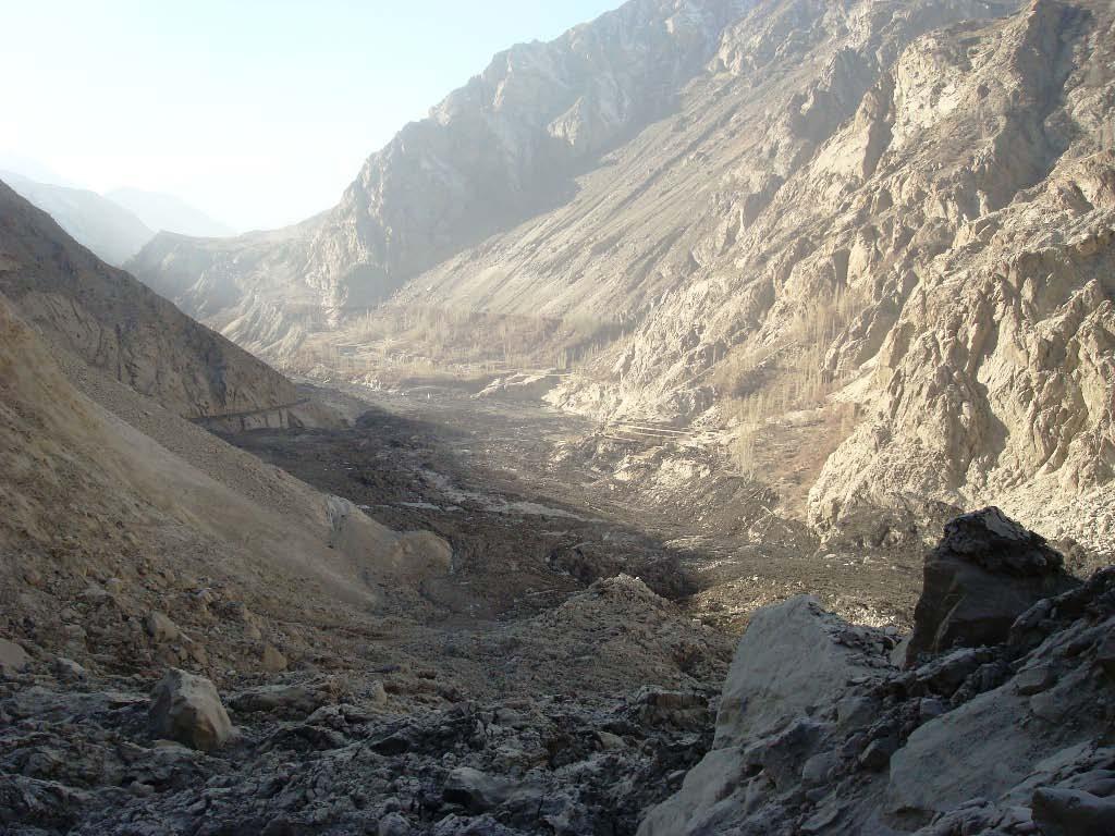
 However, final overtopping occurred later than expected because the lacustrine silts deformed, raising the floor of the")
27 Prediction of date of overtopping NDMA consistently predicted the date of overtopping incorrectly (repeatedly predicted overtopping too early) However, final overtopping occurred later than expected because the lacustrine silts deformed, raising the floor of the channel
28 Freeboard (metres) /05/ /05/ /05/2010 Date
29 14 12 Freeboard (metres) /05/ /05/ /05/ /06/2010 Date
30 Water level rise Water depth (metres) Water depth (m) Height of lowest point of completed spillway Filling rate Rate of filling (metres per day) 0-1 Date
31 Overtopping behaviour 120 Water depth (m) Height of lowest point of completed spillway Filling rate 7 Water depth (metres) Rate of filling (metres per day) Date
32 Evolution of spillway discharge Spillway discharge (cumecs)
33 Spillway discharge depth relationship Spillway discharge (cumecs) Lake depth (m)

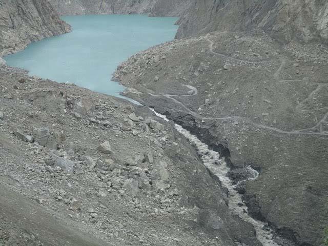
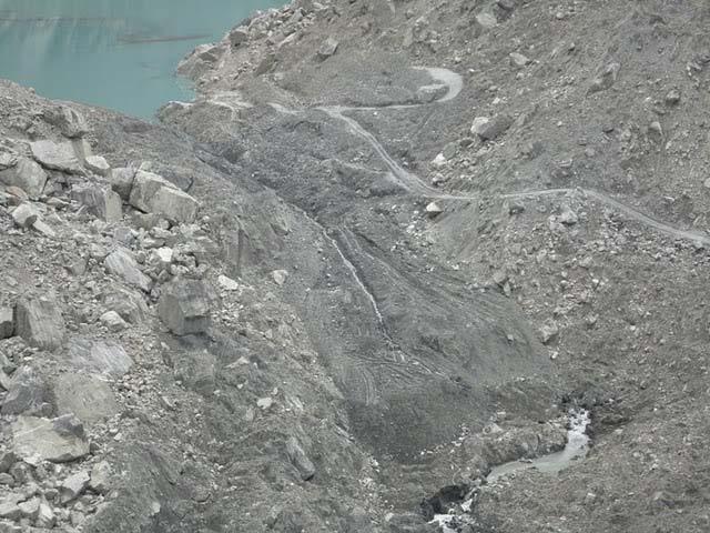
34 Spillway evolution
35
36

37 Management problems Karakoram Highway remains blocked In 2010 floods, Gilgit-Baltistan was cut off to north and south Loss of productive land Loss of cash crop markets Landslide hazard remains Progressive failure GLOF Seismic event Landslide into lake Should the lake level be lowered? FWO attempt through the winter aimed to reduce the spillway elevation by 35 metres, but achieved less than 4 metres 2011 monsoon will start in about six weeks
38 Conclusions Impacts of landslides much higher than conventionally considered Strong component is from the Himalayan Arc Attabad landslide event Long term management problems Should the dam be left alone, strengthened or lowered?
Non-seismic landslide hazards along the Himalayan Arc
 Non-seismic landslide hazards along the Himalayan Arc D.N. Petley & N.J. Rosser International Landslide Centre, Institute of Hazard, Risk and Resilience, Department of Geography, Durham University, Durham
The Attabad landslide crisis in Hunza, Pakistan lessons for the management of valley blocking landslides
 The Attabad landslide crisis in Hunza, Pakistan lessons for the management of valley blocking landslides David Petley Institute of Hazard, Risk and Resilience, and International Landslide Centre in the
UIB Network - TWG 5 Hazards and risks:
 UIB Network - TWG 5 Hazards and risks: Philippus Wester & Muhammad Asif Khan ICIMOD & Karakoram International university TWG-5 members: Arun Shrestha, Liu Shiyin, Nusrat Nasab, Deedar Karim, Muhammad Zafar
Rapid Hazard Assessment of Heavy Rainfall Triggered Landslide Dams A Review
 Rapid Hazard Assessment of Heavy Rainfall Triggered Landslide Dams A Review Focus on the developed technologies in Taiwan J. J. Dong Graduate Institute of Applied Geology, National Central University,
Tarbela Dam in Pakistan. Case study of reservoir sedimentation
 Tarbela Dam in Pakistan. HR Wallingford, Wallingford, UK Published in the proceedings of River Flow 2012, 5-7 September 2012 Abstract Reservoir sedimentation is a main concern in the Tarbela reservoir
Natural Disaster Preparedness for Hydropower Projects in High Mountain Environments
 Natural Disaster Preparedness for Hydropower Projects in High Mountain Environments John M. Reynolds Reynolds International Ltd Suite 2, Broncoed House Broncoed Business Park Wrexham Road Mold Flintshire
This report was produced and issued by OCHA Pakistan. It provides an overview of the monsoon flood situation as of 22 July 2015.
 Pakistan: Monsoon 2015 Update No. 1 (as of 22 July 2015) This report was produced and issued by OCHA Pakistan. It provides an overview of the monsoon flood situation as of 22 July 2015. Heavy monsoon rains,
DISASTER HAZARDS IN BHUTAN By Tshewang Rinzin January Reducing Disaster Risks for a Safe and Happy Bhutan
 DISASTER HAZARDS IN BHUTAN By Tshewang Rinzin 26-27 January 2009 Reducing Disaster Risks for a Safe and Happy Bhutan Disaster Hazards in Bhutan Earthquakes Glacial Lake Outburst Flood (GLOF) Floods in
Natural hazards in Glenorchy Summary Report May 2010
 Natural hazards in Glenorchy Summary Report May 2010 Contents Glenorchy s hazardscape Environment setting Flood hazard Earthquakes and seismic hazards Hazards Mass movement Summary Glossary Introduction
Dan Miller + Kelly Burnett, Kelly Christiansen, Sharon Clarke, Lee Benda. GOAL Predict Channel Characteristics in Space and Time
 Broad-Scale Models Dan Miller + Kelly Burnett, Kelly Christiansen, Sharon Clarke, Lee Benda GOAL Predict Channel Characteristics in Space and Time Assess Potential for Fish Use and Productivity Assess
Floods Lecture #21 20
 Floods 20 Lecture #21 What Is a Flood? Def: high discharge event along a river! Due to heavy rain or snow-melt During a flood, a river:! Erodes channel o Deeper & wider! Overflows channel o Deposits sediment
SECTION II Hydrological risk
 Chapter 3 Understanding disaster risk: hazard related risk issues SECTION II Hydrological risk Peter Salamon Coordinating lead author Hannah Cloke Lead author 3.4 Giuliano di Baldassarre Owen Landeg Florian
TAJIKISTAN: LAKE SAREZ AND THE PAMIR MOUNTAINS
 TAJIKISTAN: LAKE SAREZ AND THE PAMIR MOUNTAINS Lake Sarez, high in the Pamir Mountains, was created by a massive landslide dam that was caused by an earthquake in 1911. This case study centres on the question
1. INTRODUCTION. EXAMPLE OF SECHILIENNE ROCKFALL (France)
") FORM OSE POST-GRADUATE COURSE Landslide vulnerability and risk 1 FORM OSE POST-GRADUATE COURSE Landslide vulnerability and risk 2 FORM OSE POST-GRADUATE COURSE Landslide vulnerability and risk 3 Christophe
FORM OSE POST-GRADUATE COURSE Landslide vulnerability and risk 1 FORM OSE POST-GRADUATE COURSE Landslide vulnerability and risk 2 FORM OSE POST-GRADUATE COURSE Landslide vulnerability and risk 3 Christophe
GEOMORPHIC CHANGES OF A LANDSLIDE DAM BY OVERTOPPING EROSION
 DOI: 10.4408/IJEGE.2011-03.B-087 GEOMORPHIC CHANGES OF A LANDSLIDE DAM BY OVERTOPPING EROSION K. Yoshino (*), T. Uchida (*), T. shimizu (*) & K. Tamura (*) (*) Incorporated Administrative Agency, Public
Deep-Seated Landslides and Landslide Dams Characteristics Caused by Typhoon Talas at Kii Peninsula, Japan
 Deep-Seated Landslides and Landslide Dams Characteristics Caused by Typhoon Talas at Kii Peninsula, Japan Hefryan Sukma KHARISMALATRI*,1, Hitomi KIKUCHI 1, Yoshiharu ISHIKAWA 1, Takashi GOMI 1, Katsushige
Assessing Hazards and Risk
 Page 1 of 6 EENS 204 Tulane University Natural Disasters Prof. Stephen A. Nelson Assessing Hazards and Risk This page last updated on 07-Jan-2004 As discussed before, natural disasters are produced by
Flood Inundation Mapping under different climate change scenarios in the upper Indus River Basin, Pakistan
 Flood Inundation Mapping under different climate change scenarios in the upper Indus River Basin, Pakistan Sohaib Baig (doctoral student) 16 November 2017 Disaster Prevention Research Institute 1 Kyoto
Emergency Preparedness Questions
 Emergency Preparedness Questions 1. A family emergency plan should NOT include which of the following? a) Information about your children's school(s) b) The name and phone number of an out-of-town contact
ROCK AVALANCHE DAMS ON THE TRANSHIMALAYAN UPPER INDUS STREAMS: A SURVEY AND ASSESSMENT OF HAZARD-RELATED CHARACTERISTICS
 ROCK AVALANCHE DAMS ON THE TRANSHIMALAYAN UPPER INDUS STREAMS: A SURVEY AND ASSESSMENT OF HAZARD-RELATED CHARACTERISTICS Cold Regions Research Centre and Department of Geography, Wilfrid Laurier University,
APPLICATION TO PAST DISASTERS OF A METHOD OF SETTING THE RANGE OF DEBRIS FLOW DAMAGE TO HOUSES
 APPLICATION TO PAST DISASTERS OF A METHOD OF SETTING THE RANGE OF DEBRIS FLOW DAMAGE TO HOUSES Hideaki MIZUNO Senior Researcher Erosion and Sediment Control National Institute for Land and Infrastructure
GENERAL. CHAPTER 1 BACKGROUND AND PURPOSE OF THE GUIDELINES Background of the Guidelines Purpose of the Guidelines...
 GENERAL CHAPTER 1 BACKGROUND AND PURPOSE OF THE GUIDELINES... 1 1.1 Background of the Guidelines... 1 1.2 Purpose of the Guidelines... 3 CHAPTER 2 APPLICATION OF THE GUIDELINES... 3 2.1 Potential Users
Hazard Resilience Index (HRI) Earthquakes, Tsunamis, and Volcanoes
 Earthquakes, Tsunamis, and Volcanoes") Hazard Index (HRI) Earthquakes, Tsunamis, and Volcanoes Earthquakes Tsunamis Volcano-Ash Falls, Projectiles and Lateral Blasts, Pyroclastic Flows and Lava Flows Earthquakes, Tsunamis and Volcanoes Please
Hazard Index (HRI) Earthquakes, Tsunamis, and Volcanoes Earthquakes Tsunamis Volcano-Ash Falls, Projectiles and Lateral Blasts, Pyroclastic Flows and Lava Flows Earthquakes, Tsunamis and Volcanoes Please
GG101 Lecture 22: Mass Wasting. Soil, debris, sediment, and broken rock is called regolith.
 GG101 Lecture 22: Mass Wasting Mass Wasting is the movement of rock and soil down a slope due to the force of gravity. Soil, debris, sediment, and broken rock is called regolith. Mass wasting creates broad
ENGINEERING HYDROLOGY
 ENGINEERING HYDROLOGY Prof. Rajesh Bhagat Asst. Professor Civil Engineering Department Yeshwantrao Chavan College Of Engineering Nagpur B. E. (Civil Engg.) M. Tech. (Enviro. Engg.) GCOE, Amravati VNIT,
GEO The Åknes rock slope. Content. Dr. Vidar Kveldsvik NGI
 GEO 4180 The Åknes rock slope Dr. Vidar Kveldsvik NGI Content Background on large rock slides Triggers Stability analysis Risk mitigation (risk reduction) The Åknes rock slope 1 Background Landslides due
A Roundup of Recent Debris Flow Events in Taiwan
 2015 International Workshop on Typhoon and Flood APEC Experience Sharing on Hazardous Weather Events and Risk Management A Roundup of Recent Debris Flow Events in Taiwan Hsiao-Yuan(Samuel) Yin Ph.D. sammya@mail.swcb.gov.tw
THE NEED FOR AN ADDITIONAL SPILLWAY AT THE SANFORD DAM BOILING SPRING LAKES, NC. Presentation for The Brunswick County Commissioners April 20, 2015
 THE NEED FOR AN ADDITIONAL SPILLWAY AT THE SANFORD DAM BOILING SPRING LAKES, NC Presentation for The Brunswick County Commissioners April 20, 2015 The Sanford Dam Earth Dam constructed in 1961 Drainage
LECTURE #11: Volcanoes: Monitoring & Mitigation
 GEOL 0820 Ramsey Natural Disasters Spring, 2018 LECTURE #11: Volcanoes: Monitoring & Mitigation Date: 15 February 2018 I. What is volcanic monitoring? the continuous collection of one or more data sources
CASE STUDY NATHPA JHAKRI, INDIA
 SEDIMENT MANAGEMENT CASE STUDY NATHPA JHAKRI, INDIA Key project features Name: Nathpa Jhakri Country: India Category: reduce sediment production (watershed management); upstream sediment trapping; bypass
The sketch map of field investigations in Wenchuan earthquake hit region, Chengdu City.
 The sketch map of field investigations in Wenchuan earthquake hit region, Chengdu City. 1 Environmental and Geological Condition 1.1 Geomorphology BaiSha River Basin is located in Dujiangyan County, and
Interpretive Map Series 24
 Oregon Department of Geology and Mineral Industries Interpretive Map Series 24 Geologic Hazards, and Hazard Maps, and Future Damage Estimates for Six Counties in the Mid/Southern Willamette Valley Including
OIKOS > landslide > mechanism >predisposing causes
 predisposing causes and trigger OIKOS > landslide > mechanism >predisposing causes Landslides are events that occur in space and time. As such, it is usually possible to identify both one or more landslide
CASE STUDY BINGA, PHILIPPINES
 SEDIMENT MANAGEMENT CASE STUDY BINGA, PHILIPPINES Key project features Name: Binga Country: Philippines Category: modify operating rule (focus or redistribute sediment); adaptive strategies Reservoir volume
CASE STUDY BINGA, PHILIPPINES
 SEDIMENT MANAGEMENT CASE STUDY BINGA, PHILIPPINES Key project features Name: Binga Country: Philippines Category: modify operating rule (focus or redistribute sediment); adaptive strategies Binga hydropower
COMMUNITY EMERGENCY RESPONSE TEAM FLOODS INTRODUCTION
 INTRODUCTION Floods are one of the most common hazards in the United States. A flood occurs any time a body of water rises to cover what is usually dry land. Flood effects can be local, impacting a neighborhood
Controls on fluvial evacuation of sediment from earthquake-triggered landslides
 GSA DATA REPOSITORY 2015048 Controls on fluvial evacuation of sediment from earthquake-triggered landslides Jin Wang 1,2,3, Zhangdong Jin 1,4 *, Robert G. Hilton 2, Fei Zhang 1, Alexander L. Densmore 2,5,
Engineering Hydrology
 Engineering Hydrology Prof. Rajesh Bhagat Asst. Professor Civil Engineering Department Yeshwantrao Chavan College Of Engineering Nagpur B. E. (Civil Engg.) M. Tech. (Enviro. Engg.) GCOE, Amravati VNIT,
SIMPLE GUIDELINES TO MINIMISE EXPOSURE TO EARTHQUAKE-TRIGGERED LANDSLIDES
 SIMPLE GUIDELINES TO MINIMISE EXPOSURE TO EARTHQUAKE-TRIGGERED LANDSLIDES David Milledge, Nick Rosser, Katie Oven, Amod Mani Dixit, Ranjan Dhungel, Gopi Krishna Basyal, Sujan Raj Adhikari and Alexander
Modeling Great Britain s Flood Defenses. Flood Defense in Great Britain. By Dr. Yizhong Qu
 Modeling Great Britain s Flood Defenses AIRCurrents Editor s note: AIR launched its Inland Flood Model for Great Britain in December 2008. The hazard module captures the physical processes of rainfall-runoff
Streams. Stream Water Flow
 CHAPTER 14 OUTLINE Streams: Transport to the Oceans Does not contain complete lecture notes. To be used to help organize lecture notes and home/test studies. Streams Streams are the major geological agents
GUIDELINES FOR CONSTRUCTION TECHNOLOGY TRANSFER DEVELOPMENT OF WARNING AND EVACUATION SYSTEM AGAINST SEDIMENT DISASTERS IN DEVELOPING COUNTRIES
 GUIDELINES FOR CONSTRUCTION TECHNOLOGY TRANSFER DEVELOPMENT OF WARNING AND EVACUATION SYSTEM AGAINST SEDIMENT DISASTERS IN DEVELOPING COUNTRIES MARCH 2004 Ministry of Land, Infrastructure and Transport
BUILDING STRUCTURES ON OR NEAR STEEP SLOPES
 BUILDING STRUCTURES ON OR NEAR STEEP SLOPES Benefits of Building Structures on or Near Steep Slopes Why would you ever do this? In some instances, it is the steep slope that people want to be near. Like
A Presentation By: Dr. G. M. Dar Centre for Disaster Management & Env. Studies, J&K IMPA, Srinagar
 A Presentation By: Dr. G. M. Dar Centre for Disaster Management & Env. Studies, J&K IMPA, Srinagar Introduction Disaster: Sudden or great misfortune. A catastrophe, a calamitous event. Hazards are a natural
LOCATIONS OF SELECTED MITIGATION SITES IN JAPAN
 LOCATIOS OF SELECTED MITIGATIO SITES I JAPA Hyogo prefecture near Kobe, Japan Hyogo province Gifu province Osaka Kobe Gifu prefecture near Takayama, Japan akao Kamikochi ational Park Mount Yake Tateyama
The Application of Sabo Technology for Lahars Flood Mitigation and Warning System in Volcanic Area. Agus Sumaryono Bambang Sukatja F.
 The Application of Sabo Technology for Lahars Flood Mitigation and Warning System in Volcanic Area Agus Sumaryono Bambang Sukatja F. Tata Yunita BACKGROUND The Indonesia Government has constructed several
Need of Proper Development in Hilly Urban Areas to Avoid
 Need of Proper Development in Hilly Urban Areas to Avoid Landslide Hazard Dr. Arvind Phukan, P.E. Cosultant/Former Professor of Civil Engineering University of Alaska, Anchorage, USA RI District Governor
Debris flow: categories, characteristics, hazard assessment, mitigation measures. Hariklia D. SKILODIMOU, George D. BATHRELLOS
 Debris flow: categories, characteristics, hazard assessment, mitigation measures Hariklia D. SKILODIMOU, George D. BATHRELLOS Natural hazards: physical phenomena, active in geological time capable of producing
FORECAST-BASED OPERATIONS AT FOLSOM DAM AND LAKE
 FORECAST-BASED OPERATIONS AT FOLSOM DAM AND LAKE 255 237 237 237 217 217 217 200 200 200 0 163 131 Bridging the Gap163Conference 255 0 132 255 0 163 122 The Dana on Mission Bay San Diego, CA January 28,
Disaster RISK Management : Bhutanese Scenario
 Disaster RISK Management : Bhutanese Scenario Expert Group Meeting (EGM) on Geo-referenced Information Systems for Disaster Risk Management (Geo-DRM) and sustaining the Community of Practice (COP), Bangkok,
investment decisions
 Climate modelling: A guide to investment decisions Vicky Pope Met Office Hadley Centre This is not an ADB material. The views expressed in this document are the views of the author/s and/or their organizations
Earth Science Chapter 6 Section 2 Review
 Name: Class: Date: Earth Science Chapter 6 Section Review Multiple Choice Identify the choice that best completes the statement or answers the question. 1. Most streams carry the largest part of their
Running Water Earth - Chapter 16 Stan Hatfield Southwestern Illinois College
 Running Water Earth - Chapter 16 Stan Hatfield Southwestern Illinois College Hydrologic Cycle The hydrologic cycle is a summary of the circulation of Earth s water supply. Processes involved in the hydrologic
Role of Hydro-Met Services in Disaster Risk Management
 Role of Hydro-Met Services in Disaster Risk Management Tshewang Rigzin (Mr) National Centre for Hydrology and Meteorology, Bhutan 30 th November 2017 Outline Vision and Mission Functions related to Disaster
Geo-information and Disaster Risk Reduction in the Hindu Kush-Himalayan region
 Geo-information and Disaster Risk Reduction in the Hindu Kush-Himalayan region Basanta Shrestha, Division Head MENRIS, International Centre for Integrated Mountain Development Kathmandu, Nepal The International
Assessment of the catastrophic events originated in the river Vere basin
 Assessment of the catastrophic events originated in the river Vere basin Tbilisi, Georgia Presenter: Irakli Megrelidze Deputy Head of Hydrometeorological Department (National Environmental Agency) Hydrology
COPPER MOUNTAIN MINE TAILINGS MANAGEMENT FACILITY DAM BREACH INUNDATION STUDY REVISION 1. Submitted to: Copper Mountain Mine (BC) Ltd.
 Ltd.") AMEC Environment & Infrastructure a Division of AMEC Americas Limited Suite 600 4445 Lougheed Highway, Burnaby, BC Canada V5C 0E4 Tel +1 (604) 294-3811 Fax +1 (604) 294-4664 wwwameccom COPPER MOUNTAIN
AMEC Environment & Infrastructure a Division of AMEC Americas Limited Suite 600 4445 Lougheed Highway, Burnaby, BC Canada V5C 0E4 Tel +1 (604) 294-3811 Fax +1 (604) 294-4664 wwwameccom COPPER MOUNTAIN
Temperature, Snowmelt, and the Onset of Spring Season Landslides in the Central Rocky Mountains
 Temperature, Snowmelt, and the Onset of Spring Season Landslides in the Central Rocky Mountains Open-File Report 1997-027 U.S. Department of the Interior U.S. Geological Survey U.S. DEPARTMENT OF THE INTERIOR
京都大学防災研究所年報第 54 号 B 平成 23 年 6 月 Annuals of Disas. Prev. Res. Inst., Kyoto Univ., No. 54 B, 2011 Possible Scenarios for Rjecina River Catchment on the
 京都大学防災研究所年報第 54 号 B 平成 23 年 6 月 Annuals of Disas. Prev. Res. Inst., Kyoto Univ., No. 54 B, 211 Possible Scenarios for Rjecina River Catchment on the Example of Grohovo Landslide Maja OSTRIC*, Yosuke YAMASHIKI,
The effectiveness of check dams in controlling upstream channel stability in northeastern Taiwan
 Erosion, Debris Mows and Environment in Mountain Regions (Proceedings of the Chengdu Symposium, July 1992). IAHS Publ. no. 209, 1992. 423 The effectiveness of check dams in controlling upstream channel
Landscape Development
 Landscape Development Slopes Dominate Natural Landscapes Created by the interplay of tectonic and igneous activity and gradation Deformation and uplift Volcanic activity Agents of gradation Mass wasting
Jeopardy. Final Jeopardy $100 $100 $100 $100 $100 $200 $200 $200 $200 $200 $300 $300 $300 $300 $400 $400 $400 $500 $500 $500 $500 $500
 Jeopardy Earthquakes Volcanoes Tsunamis Wildfires Landslides/ Droughts $100 $100 $100 $100 $100 $200 $200 $200 $200 $200 $300 $300 $300 $300 $300 $400 $400 $400 $400 $400 $500 $500 $500 $500 $500 Final
Also, when Cascade volcanoes do erupt, high-speed avalanches of pyroclastic flows
 INTRODUCTION A volcano is a vent through which molten rock escapes to the Earth s surface. Unlike other mountains, which are pushed up from below, volcanoes are built by surface accumulation of their eruptive
UGRC 144 Science and Technology in Our Lives/Geohazards
 UGRC 144 Science and Technology in Our Lives/Geohazards Session 6 Volcanic Hazards Lecturer: Dr. Patrick Asamoah Sakyi Department of Earth Science, UG Contact Information: pasakyi@ug.edu.gh College of
Emergency Action Plan (EAP) Tata Pond Dam
 Tata Pond Dam") For Official Use Only Not for Public Distribution 02/03/16 Emergency Action Plan (EAP) Tata Pond Dam State of Connecticut Dam ID: 0000 Town or City, County, Connecticut Name of Dam Owner Dam Hazard Classification
For Official Use Only Not for Public Distribution 02/03/16 Emergency Action Plan (EAP) Tata Pond Dam State of Connecticut Dam ID: 0000 Town or City, County, Connecticut Name of Dam Owner Dam Hazard Classification
EROSION AND DEPOSITION
 CHAPTER 8 EROSION AND DEPOSITION SECTION 8 1 Changing Earth s Surface (pages 252-255) This section explains how sediment is carried away and deposited elsewhere to wear down and build up Earth s surface.
Universitas Gadjah Mada implements research, enhances knowledge, empowers society Join us to lead the way!
 SPIRIT OF MERAPI Universitas Gadjah Mada implements research, enhances knowledge, empowers society Join us to lead the way! UNIVERSITAS GADJAH MADA Yogyakarta, Indonesia SPIRIT OF MERAPI Field : Geography
Floods. Floods COMMUNITY EMERGENCY RESPONSE TEAM FLOODS CONTENT INSTRUCTOR GUIDANCE
 Floods Floods Introduce this topic by explaining that floods are one of the most common hazards in the United States. A flood occurs any time a body of water rises to cover what is usually dry land. Display
UNIT 11 SOUTH ASIA SG 1 - PHYSICAL GEOGRAPHY & THE ENVIRONMENT
 UNIT 11 SOUTH ASIA SG 1 - PHYSICAL GEOGRAPHY & THE ENVIRONMENT I. PHYSICAL GEOGRAPHY TAKE OUT YOUR PHYSICAL MAP OF SOUTH ASIA A. The Himalayan Mountains form the northern boundary of the region (color
Earthquake hazards. Aims 1. To know how hazards are classified 2. To be able to explain how the hazards occur 3. To be able to rank order hazards
 Earthquake hazards Aims 1. To know how hazards are classified 2. To be able to explain how the hazards occur 3. To be able to rank order hazards Types of hazard Primary A direct result of the earthquake
3/3/2013. The hydro cycle water returns from the sea. All "toilet to tap." Introduction to Environmental Geology, 5e
 Introduction to Environmental Geology, 5e Running Water: summary in haiku form Edward A. Keller Chapter 9 Rivers and Flooding Lecture Presentation prepared by X. Mara Chen, Salisbury University The hydro
Phase II Report: Project Definition Options. Dam Safety
 OSHPC BARKI TOJIK Phase II Report: Project Definition Options Dam Safety Part 1: Basic data & Dam Design DAM Safety 2 Geology / Geotechnics...: Tectonics / Seismicity : DAM Design - Dam Location - Type
CASE STUDY NATHPA JHAKRI, INDIA
 SEDIMENT MANAGEMENT CASE STUDY NATHPA JHAKRI, INDIA Key project features Name: Nathpa Jhakri Country: India Category: reforestation/revegetation; upstream sediment trapping; bypass channel/tunnel; reservoir
MODELLING FROST RISK IN APPLE TREE, IRAN. Mohammad Rahimi
 WMO Regional Seminar on strategic Capacity Development of National Meteorological and Hydrological Services in RA II (Opportunity and Challenges in 21th century) Tashkent, Uzbekistan, 3-4 December 2008
Evidence for plate tectonics
 Evidence for plate tectonics See class powerpoint Printed tables 2x essay Qs markschemes Discuss/Evaluate the evidence for plate tectonics Discuss/evaluate the evidence for plate tectonics Essay: To what
STEUBEN COUNTY, NEW YORK. Hazard Analysis Report
 STEUBEN COUNTY, NEW YORK Hazard Analysis Report Prepared by: April 1, 2014 Background On April 1, 2014 the Steuben County Office of Emergency Management conducted a hazard analysis using the automated
GLACIAL LAKE OUTBURST FLOODS IN THE NEPAL HIMALAYA JONATHAN M LALA UNIVERSITY OF TEXAS AT AUSTIN CE 394K.3 GIS IN WATER RESOURCES DECEMBER 2, 2016
 GLACIAL LAKE OUTBURST FLOODS IN THE NEPAL HIMALAYA JONATHAN M LALA UNIVERSITY OF TEXAS AT AUSTIN CE 394K.3 GIS IN WATER RESOURCES DECEMBER 2, 2016 TABLE OF CONTENTS Abstract... 3 Introduction... 3 Methods...
Volcanoes. Introduction
 Volcanoes Introduction Display Slide V-0 Explain that a volcano is a vent through which molten rock escapes to the Earth s surface. Unlike other mountains, which are pushed up from below, volcanoes are
Attachment B to Technical Memorandum No.2. Operations Plan of Ross Valley Detention Basins
 Attachment B to Technical Memorandum No.2 Operations Plan of Ross Valley Detention Basins Operations Plan of Ross Valley Detention Basins Stetson Engineers Inc. January 26, 2011 1.0 Introduction Achieving
Wednesday, March 27, 2019
 Wednesday, March 27, 2019 8:30 a.m. EDT Significant Activity Mar 26-27 Significant Events: Central U.S. Mississippi Valley Flooding Tropical Activity: No activity affecting U.S. interests Significant Weather:
Running Head: HAZARD MITIGATION PLAN OUTLINE FOR MISSISSIPPI 1
 Running Head: HAZARD MITIGATION PLAN OUTLINE FOR MISSISSIPPI 1 Hazard Mitigation Plan Outline for Mississippi Name: Institution: HAZARD MITIGATION PLAN OUTLINE FOR MISSISSIPPI 2 Hazard Mitigation Plan
Geophysics the use of geology, laboratory & field experiments, mathematics, and instruments to study: Earthquakes and Volcanoes seismometers,
 Geophysics the use of geology, laboratory & field experiments, mathematics, and instruments to study: Earthquakes and Volcanoes seismometers, tiltmeters, EDM, remote sensing, Energy: oil, gas, hydrothermal
New A-Level Physical Geography
 Half Term 1 3.1 Physical Geography: 3.1.5 Hazards: Plate Tectonics This optional section of our specification focuses on the lithosphere and the atmosphere, which intermittently but regularly present natural
STREAM SYSTEMS and FLOODS
 STREAM SYSTEMS and FLOODS The Hydrologic Cycle Precipitation Evaporation Infiltration Runoff Transpiration Earth s Water and the Hydrologic Cycle The Hydrologic Cycle The Hydrologic Cycle Oceans not filling
Precipitation Evaporation Infiltration Earth s Water and the Hydrologic Cycle. Runoff Transpiration
 STREAM SYSTEMS and FLOODS The Hydrologic Cycle Precipitation Evaporation Infiltration Earth s Water and the Hydrologic Cycle Runoff Transpiration The Hydrologic Cycle The Hydrologic Cycle Oceans not filling
Disaster Risk Reduction and
 6 th ICRM Symposium 2015 Disaster Risk Reduction and 2015/04/23 Resilience in Taipei Outline Natural Disaster and Loss in Taiwan Climate Change and Geohazard Hazard Alert & App Monitoring & Modeling Land
Fluvial Systems Lab Environmental Geology Lab Dr. Johnson
 Fluvial Systems Lab Environmental Geology Lab Dr. Johnson *Introductory sections of this lab were adapted from Pidwirny, M. (2006). "Streamflow and Fluvial Processes". Fundamentals of Physical Geography,
U-Shaped Sediment Traps
 U-Shaped Sediment Traps SEDIMENT CONTROL TECHNIQUE Type 1 System Sheet Flow Sandy Soils Type 2 System Concentrated Flow Clayey Soils [1] Type 3 System Supplementary Trap Dispersive Soils [1] Generally
4.1 Hazard Identification: Natural Hazards
 data is provided in an annex, it should be assumed that the risk and potential impacts to the affected jurisdiction are similar to those described here for the entire Sacramento County Planning Area. This
President s Day Weekend Storm Community Meeting and Workshop April 17, 2017
 President s Day Weekend Storm Community Meeting and Workshop April 17, 2017 Meeting outline 1. Progress update on the City of San Jose s recovery efforts 2. Water district presentation on: Weather situation
SPECIFIC DEGRADATION AND RESERVOIR SEDIMENTATION. By Renee Vandermause & Chun-Yao Yang
 SPECIFIC DEGRADATION AND RESERVOIR SEDIMENTATION By Renee Vandermause & Chun-Yao Yang Outline Sediment Degradation - Erosion vs Sediment Yield - Sediment Yield - Methods for estimation - Defining Sediment
Section 5. Low-Gradient Streams. What Do You See? Think About It. Investigate. Learning Outcomes
 Chapter 4 Surface Processes Section 5 Low-Gradient Streams What Do You See? Learning Outcomes In this section, you will Use models and real-time streamflow data to understand the characteristics of lowgradient
Flood Hazard Vulnerability Mapping Using Remote Sensing and GIS: A Case Study of Surat Dhruvesh KM 1*, Praful MU 2 and Aditya MV 1 1
 Flood Hazard Vulnerability Mapping Using Remote Sensing and GIS: A Case Study of Surat Dhruvesh KM 1*, Praful MU 2 and Aditya MV 1 1 CU Shah University, Wadhwan, India 2 ISTAR-CVM, Vallabh Vidyanagar,
Daily Operations Briefing Monday, February 13, :30 a.m. EST
 Daily Operations Briefing Monday, February 13, 2017 8:30 a.m. EST Significant Activity Feb 10-13 Significant Events: Oroville Dam Spillway Erosion CA Significant Weather: Heavy Snow Southwest to Southern
Landslide lesson plan
 Landslide lesson plan The landslide lesson plan provides teachers and students with an opportunity to investigate the elements that contribute to shaping landforms and the effects of landslides. ITEMS
ONTARIO REGULATION 156/06. made under the CONSERVATION AUTHORITIES ACT
 ONTARIO REGULATION 156/06 made under the CONSERVATION AUTHORITIES ACT Made: April 28, 2006 Approved: May 4, 2006 Filed: May 4, 2006 Published on e-laws: May 8, 2006 Printed in The Ontario Gazette: May
Practical aspects of dam break analysis
 Practical aspects of dam break analysis Louis C Hattingh Hattingh Anderson Associates CC Dam break analysis It is a model You need to understand what you model & have an idea of the answers that you expect
Hazard-specific Flash Flood Management Measures
 Chapter 6 Hazard-specific Flash Flood Management Measures Chapter 5 outlined general, non-structural measures of risk management that are applicable to any type of flash flood. However, proper management
USGS scientists with Venezuelan military liaisons.
 USGS scientists with Venezuelan military liaisons. In December, 1999, heavy rainfall triggered thousands of debris flows and caused numerous flash floods in a 300- kilometer long area of the north coast
Major External Processes Driven by energy from the sun and from gravity. Also create hazards and resources.
 Geologic Processes and Hazards Definition of Geology External and Internal Processes: examples of each Fundamentals of Plate Tectonics: definition, types of boundaries, general geography, hazards & resources