Technical Memorandum
|
|
|
- Lambert Skinner
- 6 years ago
- Views:
Transcription


1

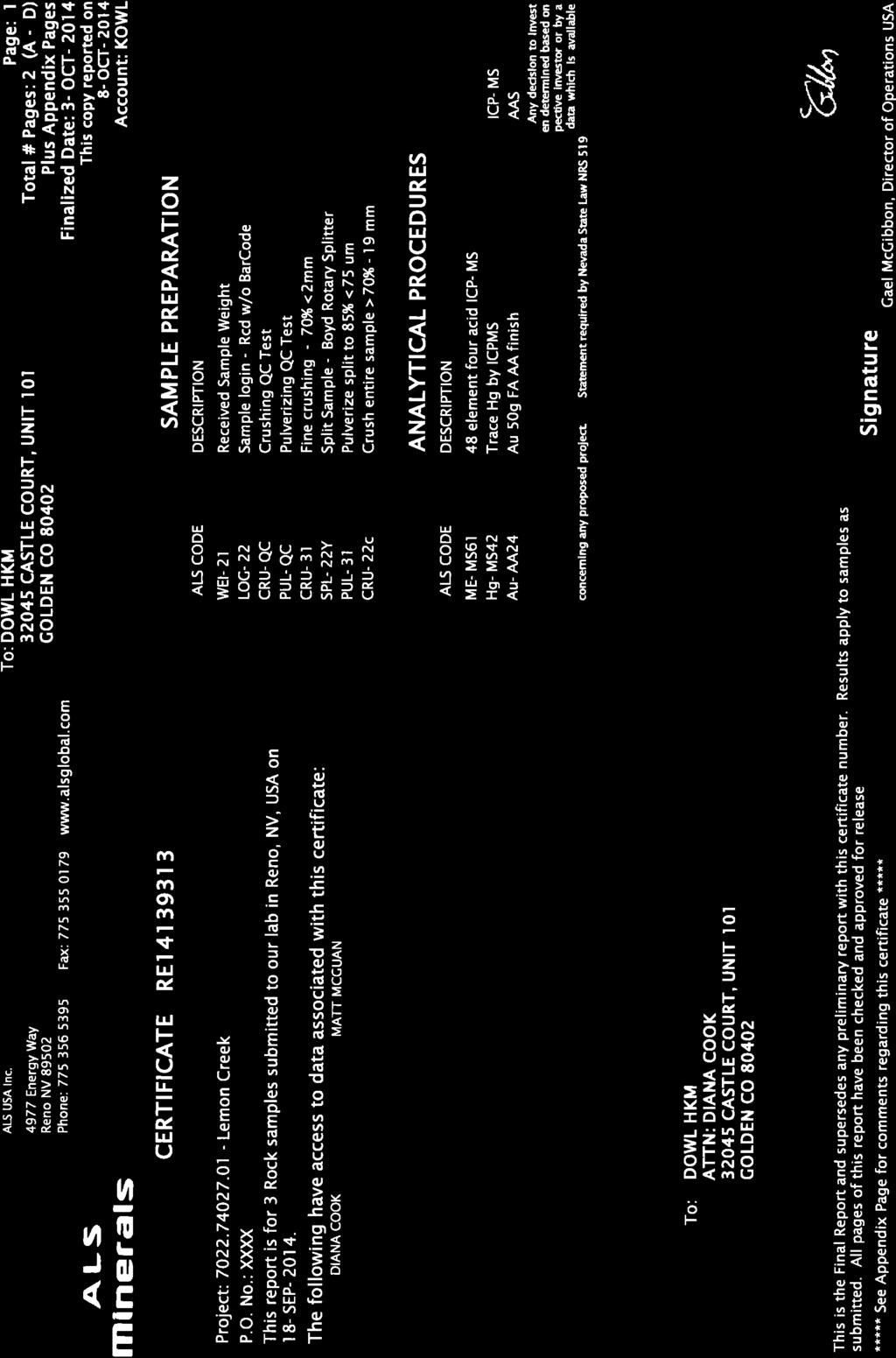
2 Technical Memorandum To: Ke E. Mell From: Mike Henderson, P.E. Diana Cook, Ph.D., P.E. Company: University of Alaska Southeast Date: November 13, 2014 Re: Site Mapping Underground Mine Training Facility Project #: Lemon Creek Area, Juneau, Alaska CC: Document #: Tech Memo #1 1.0 Introduction The University of Alaska Southeast (UAS) is proposing to construct an underground mine training facility in the Lemon Creek area of the City and Borough of Juneau, Alaska. The proposed portal is located in a historic rock quarry. DOWL HKM understands a short mine tunnel, approximately 750 feet in total length, will be created in the rock wall during training courses for drilling, blasting, mucking, and hauling. To assist in planning of the facility, DOWL HKM recently conducted a brief site visit to provide geological and structural mapping of the rock mass at the proposed portal. The data collected from the mapping program was used to evaluate potential rockfall issues near the proposed portal area and provide recommendations for an initial drilling and sampling program targeted to the specific site geology and rock structure. This strategy was employed by DOWL HKM to reduce the number of boreholes originally planned for the site. This memorandum provides a summary of the site mapping, rockfall evaluation, and recommendations for further investigations at the site. Portal Lemon Creek Figure 1: Portal Site Location Relative to Lemon Creek in Juneau, Alaska (not to scale). Site Mapping, UAS Mine Training Facility November 13, 2014
3 2.0 Scope of Work The following tasks were completed in support of the planned portal: Task 1 - Site Reconnaissance and Mapping Task 2 - Kinematic Analysis Task 3 - Laboratory Testing Task 4 - Summary Report The results of these tasks are discussed in the sections below. In addition, recommendations for drilling and further site improvement work are included at the end of this report. 3.0 Geologic Conditions Regionally, the Juneau area exhibits a complex geology comprised of glacial and alluvial surficial materials overlain by variably metamorphosed sedimentary, volcanic, and intrusive rocks. The area is geologically young, with active tectonism and uplift, and historic glaciation has resulted in an oversteepening of the slopes. Two major joint surfaces, which may be due to isostatic rebound following withdrawal of glacial pressure, dominate the slopes around Juneau, including those in the Lemon Creek area: one generally strikes perpendicular to the slopes and dips northwestward at 55 to 80 degrees, and the other strikes parallel to the slopes and dips southwestward at about 65 degrees (Swanston, 1972). The steepened slopes, jointed rock, freeze-thaw weathering, and high rainfall characteristic of the area all contribute to rockfall potential in the Juneau area. 4.0 Field Investigation and Observations The site reconnaissance program included observations regarding rock types and condition, slope condition, and seepage. The upper portions of the slope, above the proposed portal, were not readily accessible due to the steepness of the slopes and the thickness of the vegetation. Locally, the rock face is composed of greenish-grey, tightly folded and interbedded slate, phyllite, schist, and gneiss, with occasional white quartz veins. Parent materials are likely shales, sandstones, intrusive granites, and volcanic andesite. These variably metamorphosed rocks are moderately hard to extremely hard, with moderate to slight weathering, including areas of slight oxidation staining, and exhibit moderate to heavy mineral alignment. A hard contact between rock types is not apparent, however, the prevalence of gneiss was noted to decrease, and the quantity of slate to increase, moving southward along the rock wall of the historic quarry (Figure 2). This relatively subtle change in geology within a short distance impacts the orientation and frequency of jointing, and therefore the stability of the slopes towards the south of the quarry wall. The greater portion of gneiss in the north results in greater stability compared to the southern portion of the site, where a corresponding increase in the accumulation of talus is also noted (Figures 3 and 4). The more competent rock in the northern portion of the site will provide the best location for the portal, and this is where the scanline mapping of discontinuities was performed. Site Mapping, UAS Mine Training Facility November 13, 2014
.")

4 Figure 2: Approximate contact showing location where gneiss decreases and slate increases along the quarry wall. Note increased pattern in jointing on the right side of the photo (south side of the site). The edge of the pond is located in the left corner of the photo. Figure 3: Northern section of the site, exhibiting relatively competent bedrock. Site Mapping, UAS Mine Training Facility November 13, 2014

5 Figure 4: Southern section of the site, showing increased jointing and slope talus. A scanline, or fixed line survey, is an inventory of the major structural discontinuities that intersect a linear traverse of specified length and orientation. The survey is used to determine average joint spacing for prominent joint sets, and therefore the average block size. Scanline mapping at Lemon Creek took place on September 4 and 5, 2014, for a 100-foot section parallel to the rock face where the portal will be located. The rock face strikes roughly north-south, at an azimuth of approximately 358 degrees. The rock face dips to the west at about 75 degrees. Access to the portal face was limited due to the presence of ponded water, estimated at up to 10 feet deep in some areas (Figure 5). The scanline was therefore mapped at a distance, using survey equipment to measure joint spacing. Dip and dip direction were measured indirectly from beyond the pond using a Brunton Geo Transit compass. The accuracy of these measurements is not anticipated to vary significantly from those that would have been taken directly at the face, as the dip and dip direction will vary slightly along individual joints; measurements taken at a distance from the rock face are more likely to account for this variation along individual joints, even if the measurement does not reflect the precise dip and dip direction measured exactly at the intersection of the joint with the scanline. Joint condition, including infilling, presence of water, roughness, etc., was also generally assessed from a distance and by inspection of similar joints that were accessible on either side of the pond. Site Mapping, UAS Mine Training Facility November 13, 2014

6 Figure 5: Rock face at portal location, with ponded water at the base. Joints typically were wet or flowing with water, exhibited high roughness, and had apertures varying from hairline fractures to wide openings a few inches across, with moderate to high persistence across the face. Infilling consisted of gravely sand with silt, with frequent heavy moss growth (Figure 6), particularly where flowing water was noted. Plant growth within the fractures was also common. Site Mapping, UAS Mine Training Facility November 13, 2014
.")
7 Figure 6: Typical joint condition, showing moss growth and flowing water. Some joint sets did not intersect the scanline, particularly those dipping out of the slope (striking parallel to the scanline). These were sampled randomly, and included with the rest of the data collected and used to assess the potential for, and likely failure mechanisms of, rockfall at the portal. The talus materials on site include fines (i.e., clay and silt) up to boulders several feet in diameter. Some movement of the materials downslope is clear, however, it is not known to what extent the conditions observed are natural, or to what degree the steepness of the slopes, jointing patterns, and/or movement of materials were influenced by historic quarry activities, such as blasting. Site Mapping, UAS Mine Training Facility November 13, 2014
8 5.0 Evaluation of Rockfall Potential Discontinuity data collected at the site were entered into Rocscience s Dips program to evaluate the dominant discontinuity sets for the proposed portal site. The joint pole (defined as the unique trend and plunge of a line perpendicular to the joint plane) data were plotted on an equal-angle stereograph (which is a 3-D stereographic display of orientation data) and contoured to show the density concentration of the measurements. The orientation of the center of distribution represents the average orientation of the set. For example, Joint Set 1, shown in Figure 7, dips steeply (as represented by the large distance from the center of the circle) to the northwest (azimuth of 323 degrees). Figure 7 indicates that there are at least five major joint sets at the portal. These joint sets are also outlined in Figure 8 to show the relationship between the poles plotted in the stereograph and the actual joints in the outcrop. The joint sets are summarized in Table 1. Joint Set 1 Figure 7: The 5 major joint sets measured at the Lemon Creek portal location. Site Mapping, UAS Mine Training Facility November 13, 2014

9 Figure 8: Approximate portal location (not to scale) and major joint sets. Joint Set 1 is shown in blue, Joint Set 2 in red, Joint Set 3 in green, Joint Set 4 in Purple, and Joint Set 5 in black. The color coding corresponds to the stereonet in Figure 7. Joint Set Table 1: Major joint set data at the proposed Lemon Creek portal Average Dip (degrees) Average Dip Direction (degrees) Code Color Approximate Joint Spacing (ft) Set Blue 9 Set Red 3 Set Green 1 Set Purple 7 Set Black 1 Site Mapping, UAS Mine Training Facility November 13, 2014
10 Three site characteristics at the Lemon Creek portal have the greatest impact on slope stability: rock discontinuities and their orientations, the steepness of the rock face or slope, and infiltration of precipitation. Discontinuities (bedding planes, cleavage, joints, and faults) found in the rock contribute significantly to destabilize the slope face. Most of the discontinuities dip toward the north/northwest and to the west (Joint sets 1, 2, and 4); however, the highly variable nature of the metamorphic materials on site could conceivably contribute to a failure on any face. Three modes of failure were analyzed using Rocscience software, including Swedge and RocPlane: planar failure, wedge failure, and topple failure. A planar failure may occur when a discontinuity dips in the same direction as the slope, but at a shallower angle, intersecting the slope face. Wedge failures occur when two discontinuity sets intersect such that the line of intersection is inclined out of the slope face. Toppling may occur when a steeply-dipping discontinuity with a dip direction opposite or nearopposite the slope creates an unstable rock mass. Slopes which strike within 30 of the discontinuity dip direction have the potential to produce a topple failure. Joint Set 2 dips out of the slope, to the west, and offers the greatest potential for the development of planar failures. Blocks may slide along this joint surface, and potential failures involving this joint are compounded by the development of wedges between Joint Set 2 and Joint Set 5, which dips opposite of Joint Set 2 and into the rock face. Kinematic analyses, using the data collected and typical joint strength parameters for metamorphic rocks, indicate a high likelihood for wedge failures between these joints, even for dewatered conditions. The presence of water in the joints will serve to increase the likelihood for block instability due to the build-up of pore pressures in the rock discontinuities, along with the accelerated weathering and freeze-thaw mechanisms for loosening the rock blocks over time. Planar failures along Joint Set 3 are also possible, as is the potential for wedge failures between Joint Set 3 (dipping to the southwest) and Joint Set 5, though Joint Set 3 is much less prevalent at the portal location than in the southern half of the site. Joint Sets 1 and 4 strike perpendicular to the slope, and therefore do not significantly impact the rockfall potential. Toppling failure is theoretically possible at the site, but is not considered a likely mechanism for significant contributions to rockfall occurrences at this location. In addition, based on the metamorphic and foliated nature of the bedrock, it is not anticipated that any topple-like failures would encompass the height of the rock face. More likely, this sort of failure will occur as minor raveling. 6.0 Laboratory Testing Three (3) samples were collected at the portal location and shipped to the ALS Geochemistry laboratory in Reno, Nevada. Laboratory testing included a 49-element inductively coupled plasma (ICP) analysis by mass spec (MEMS61-M) and a test for gold by fire assay (AU-AA23) on each sample to determine whether economically viable minerals (e.g., gold, silver, copper, zinc, lead) are present at the site, as well as the potential for the presence of hazardous elements (arsenic, mercury, sulfides). In general, the geochemical testing indicated an absence of economically viable minerals and/or potentially hazardous elements. Testing did indicate high levels of aluminum, but the aluminum is not considered economically recoverable. The results are included in Appendix A. Site Mapping, UAS Mine Training Facility November 13, 2014
11 7.0 Conclusions and Recommendations The proposed location for the UAS training mine portal at the Lemon Creek Quarry site appears technically viable. Analytical laboratory testing indicates the rock at the site does not contain significant quantities of economic or hazardous elements. In addition, the rock, while moderately jointed, is likely to be sufficiently competent to support the proposed tunneling activities, with proper design. While rockfall appears to pose a credible risk at the site, this risk can be controlled through appropriate mitigation techniques, such as scaling, rock bolting, and placement of wire mesh over the exposed slope. In order to progress the project to design, DOWL HKM recommends inclusion of the following tasks for Phase 2 - Detailed Investigations: Core Drilling 250 to 300 feet into the rock face; In-situ permeability testing; Laboratory testing; Additional collection/evaluation of discontinuity data; and Site survey. Based on the geology and orientation of the major joint sets at the location of the proposed portal, DOWL HKM recommends drilling two (2) boreholes using continuous, HQ-size wire line coring with triple-tube technology. The core should be oriented in order to provide for accurate measurement of the discontinuities, or, alternatively, a televiewer may be used directly following coring to view the orientation of the discontinuity sets relative to the boreholes. The first borehole (BH-1, shown in Figure 9) should be located parallel to the proposed tunnel alignment, and should extend at a positive incline of 2 percent from horizontal (to mimic the incline of the drift and promote dewatering) for a length of approximately 75 feet in order to fully encompass the initial length (50 feet) of the tunnel that will be excavated at the start of the project. The second borehole (BH-2 in Figure 9) should be located at a distance of approximately 145 feet from the center of the portal (near the southern boundary of the quarry wall), and drilled at an azimuth of approximately 10 degrees (to intersect the prominent joint sets), and should extend horizontally for a length of approximately 175 feet. This will also allow the borehole to intersect the proposed tunnel alignment. In addition to the coring proposed for Phase 2 of this project, further studies, as outlined above, should be performed during Phase 2 to more precisely define the discontinuities, rock strength characteristics, and dewatering requirements for the purposes of designing the rockfall mitigation and initial tunneling support. This may include, but not be limited to, determining Rock Quality Designation (RQD) on core, laboratory testing, in-situ permeability and strength testing, laser scanning of the rock face, etc. At a minimum, core samples retrieved during drilling should be used to mechanically classify the rock (e.g., RQD, Q or Tunnel rating, etc.) and perform the following tests: Confined Compressive and Tensile Strength; Unconfined Compressive Strength (UCS); Moisture Content; Density; and Slake Durability, if applicable. Site Mapping, UAS Mine Training Facility November 13, 2014
 and compacted fill placed in the pond void to prevent future ponding. The fill should be graded to promote drainage away from the portal.")
12 Log Piles Portal Pond BH 1 Talus BH 2 North Not to Scale Figure 9: Site map showing proposed boring locations, pond, log piles, and talus (not to scale). Prior to drilling, the pond will need to be dewatered (pumped) and compacted fill placed in the pond void to prevent future ponding. The fill should be graded to promote drainage away from the portal. Site surveying should also take place prior to drilling for the purposes of more accurately defining the portal location, borehole locations, and site grading/access requirements including the potential need for the removal of logs and/or talus, etc. Due to the temporary nature of the drilling, rockfall is not anticipated to present a significant risk to this task, however, the slope can be scaled to remove loose rocks, exposed casing (e.g., 10 to 15 feet) can be used during drilling to provide a safety setback for the drillers, and a concrete barrier can be placed between the rock face and the drill rig to catch any material that may fall during drilling. In addition, appropriate safety precautions should be taken to avoid injury due to rockfall (i.e., Personal Protection Equipment (PPE) such as hard hats, steel toe boots, etc.). A DOWL HKM geologist or geological engineer will be present on site to supervise the drilling, including assessing and monitoring rock fall issues as drilling progresses. Additional details regarding the Phase 2 scope will be provided by DOWL HKM upon request. Site Mapping, UAS Mine Training Facility November 13, 2014
13 8.0 References Rocscience, 2014, Dips, Swedge, and RocPlane software, Toronto, Ontario, Canada. Swanston, D. N. 1972, A report on the mass wasting (landslide) hazards in the urban and urbanizing areas of the city and borough of Juneau, Alaska Publication No Site Mapping, UAS Mine Training Facility November 13, 2014
14 APPENDIX A Site Mapping, UAS Mine Training Facility November 13, 2014
15

16

17

18


19

20
Evaluation of Structural Geology of Jabal Omar
 International Journal of Engineering Research and Development e-issn: 2278-067X, p-issn: 2278-800X, www.ijerd.com Volume 11, Issue 01 (January 2015), PP.67-72 Dafalla Siddig Dafalla * and Ibrahim Abdel
ENGINEERING EVALUATION OF THE STANLEY MINE ADVENTURE PARK AREA CLEAR CREEK COUNTY, COLORADO. Prepared for:
 braun Braun Consulting Engineers ENGINEERING EVALUATION OF THE STANLEY MINE ADVENTURE PARK AREA CLEAR CREEK COUNTY, COLORADO Prepared for: STANLEY MINES ADENTURE PARK 3375 W. POWERS CIRCLE LITTLETON, COLORADO
3.12 Geology and Topography Affected Environment
 3 Affected Environment and Environmental Consequences 3.12 Geology and Topography 3.12.1 Affected Environment 3.12.1.1 Earthquakes Sterling Highway MP 45 60 Project Draft SEIS The Kenai Peninsula is predisposed
Oktoberforum 2005: Case Histories in Engineering Geology and Geotechnical Engineering,, 4 th Oct. 2005, Petaling Jaya
 IEM-GSM Oktoberforum 2005: Case Histories in Engineering Geology and Geotechnical Engineering,, 4 th Oct. 2005, Petaling Jaya DISCONTINUITIES STUDY AND ROCK SLOPES STABILITY ANALYSIS FOR ROCK MASS AT DAMANSARA
 Rock Slope Analysis Small and Large Scale Failures Mode of Failure Marklands Test To establish the possibility of wedge failure. Plane failure is a special case of wedge failure. Sliding along
NOA ASSESSMENT HARRIS QUARRY MENDOCINO COUNTY, CALIFORNIA TABLE OF CONTENTS
 NOA ASSESSMENT HARRIS QUARRY MENDOCINO COUNTY, CALIFORNIA TABLE OF CONTENTS Introduction... 1 Scope of Services... 1 Project Location and Description... 1 Geologic Setting... 1 Regional Geology... 1 Site
Answers: Internal Processes and Structures (Isostasy)
") Answers: Internal Processes and Structures (Isostasy) 1. Analyse the adjustment of the crust to changes in loads associated with volcanism, mountain building, erosion, and glaciation by using the concept
Answers: Internal Processes and Structures (Isostasy) 1. Analyse the adjustment of the crust to changes in loads associated with volcanism, mountain building, erosion, and glaciation by using the concept
10. GEOTECHNICAL EXPLORATION PROGRAM
 Geotechnical site investigations should be conducted in multiple phases to obtain data for use during the planning and design of the tunnel system. Geotechnical investigations typically are performed in
CHAPTER FIVE 5.0 STABILITY OF CUT SLOPES IN THE STUDY AREA. them limited by a thick canopy of vegetation and steep slope angles.
 CHAPTER FIVE 5.0 STABILITY OF CUT SLOPES IN THE STUDY AREA 5.1. Introduction Ukay Perdana area is a developing community with continuous building activities and road construction. There are thus only left
=%REPORT RECONNAISSANCE OF CHISHOLM LAKE PROSPECT. October 25, 1977
 =%REPORT ON FIELD RECONNAISSANCE OF CHISHOLM LAKE PROSPECT October 25, 1977 Bruce D. Vincent Imperial Oil Limited, Minerals - Coal, CALGARY, ALBERTA CHISHOLM LAKE PROSPECT Introduction The Chisholm Lake
Unsafe Ground: Landslides and Other Mass Movements
 Unsafe Ground: Landslides and Other Mass Movements Mass Movements Downslope motion of earth materials by gravity. Mass movements are a type of natural hazard. Natural feature of the environment. Can cause
Slope Stability Evaluation Ground Anchor Construction Area White Point Landslide San Pedro District Los Angeles, California.
 Slope Stability Evaluation Ground Anchor Construction Area White Point Landslide San Pedro District Los Angeles, California Submitted To: Mr. Gene Edwards City of Los Angeles Department of Public Works
Assessment of rock slope stability using remote sensing technique in the Gold Coast area, Australia
 Assessment of rock slope stability using remote sensing technique in the Gold Coast area, Australia Author Gratchev, Ivan, Shokouhi, A., Kim, Dong Hyun, Stead, D., Wolter, A. Published 2013 Conference
Underground Excavation Design Classification
 Underground Excavation Design Underground Excavation Design Classification Alfred H. Zettler alfred.zettler@gmx.at Rock Quality Designation Measurement and calculation of RQD Rock Quality Designation index
Mass Wasting. Revisit: Erosion, Transportation, and Deposition
 Mass Wasting Revisit: Erosion, Transportation, and Deposition While landslides are a normal part of erosion and surface processes, they can be very destructive to life and property! - Mass wasting: downslope
SLOPE STABILITY EVALUATION AND ACCEPTANCE STANDARDS
 INFORMATION BULLETIN / PUBLIC - BUILDING CODE REFERENCE NO.: LABC 7006.3, 7014.1 Effective: 01-01-2017 DOCUMENT NO.: P/BC 2017-049 Revised: 12-21-2016 Previously Issued As: P/BC 2014-049 SLOPE STABILITY
Geology 229 Engineering Geology. Lecture 7. Rocks and Concrete as Engineering Material (West, Ch. 6)
") Geology 229 Engineering Geology Lecture 7 Rocks and Concrete as Engineering Material (West, Ch. 6) Outline of this Lecture 1. Rock mass properties Weakness planes control rock mass strength; Rock textures;
Geology 229 Engineering Geology Lecture 7 Rocks and Concrete as Engineering Material (West, Ch. 6) Outline of this Lecture 1. Rock mass properties Weakness planes control rock mass strength; Rock textures;
Rock slope rock wedge stability
 Engineering manual No. 28 Updated: 02/2018 Rock slope rock wedge stability Program: Rock stability File: Demo_manual_28.gsk The aim of the chapter of this engineering manual is to explain a rock slope
Mass Wasting. Requirements for Mass Wasting. Slope Stability. Geol 104: mass wasting
 Mass Wasting Movement of earth materials downslope, driven by Gravitational Forces. Landslides - general term for rock or soil movement. In U.S., on average, mass wasting causes 1 to 2 billion dollars
ENGINEERING GEOLOGY AND ROCK MECHANICS
 ENGINEERING GEOLOGY AND ROCK MECHANICS SKAA 2712 ENGINEERING PROPERTIES OF ROCK MASSES PROF. MADYA DR. EDY TONNIZAM BIN MOHAMAD DEPT. OF GEOTECHNICS AND TRANSPORTATION FACULTY OF CIVIL ENGINEERING UTM
J. Paul Guyer, P.E., R.A.
 J. Paul Guyer, P.E., R.A. Paul Guyer is a registered mechanical engineer, civil engineer, fire protection engineer and architect with over 35 years experience in the design of buildings and related infrastructure.
NAME HOMEWORK ASSIGNMENT #3 MATERIAL COVERS CHAPTERS 8, 9, 10, 11
 NAME HOMEWORK ASSIGNMENT #3 MATERIAL OVERS HAPTERS 8, 9, 10, 11 Assignment is due the beginning of the class period on November 23, 2004. Answers for each chapter will be discussed in class, as Exam #3
ENGINEER S CERTIFICATION OF FAULT AREA DEMONSTRATION (40 CFR )
") PLATTE RIVER POWER AUTHORITY RAWHIDE ENERGY STATION BOTTOM ASH TRANSFER (BAT) IMPOUNDMENTS LARIMER COUNTY, CO ENGINEER S CERTIFICATION OF FAULT AREA DEMONSTRATION (40 CFR 257.62) FOR COAL COMBUSTION RESIDUALS
PLATTE RIVER POWER AUTHORITY RAWHIDE ENERGY STATION BOTTOM ASH TRANSFER (BAT) IMPOUNDMENTS LARIMER COUNTY, CO ENGINEER S CERTIFICATION OF FAULT AREA DEMONSTRATION (40 CFR 257.62) FOR COAL COMBUSTION RESIDUALS
Data Report for White Point Landslide Boring B-12 W.O. E Task Order Solicitation San Pedro District Los Angeles, California
 Data Report for White Point Landslide Boring B-12 W.O. E1907483 Task Order Solicitation 11-087 San Pedro District Los Angeles, California Submitted To: Mr. Christopher F. Johnson, P.E., G.E. City of Los
B) color B) Sediment must be compacted and cemented before it can change to sedimentary rock. D) igneous, metamorphic, and sedimentary rocks
 color B) Sediment must be compacted and cemented before it can change to sedimentary rock. D) igneous, metamorphic, and sedimentary rocks") 1. Which characteristic of nonsedimentary rocks would provide the least evidence about the environment in which the rocks were formed? A) structure B) color C) crystal size D) mineral composition 2. Which
1. Which characteristic of nonsedimentary rocks would provide the least evidence about the environment in which the rocks were formed? A) structure B) color C) crystal size D) mineral composition 2. Which
Appendix 6 Geotechnical report
 Page 56 Appendix 6 Geotechnical report 1. Introduction The following provides an initial and preliminary description/assessment of the overall geology, the likely ground conditions and preliminary geotechnical
August 31, 2006 Embankment Failure Debris Flow at the Cascades Development Haywood County, North Carolina. Introduction. Findings
 August 31, 2006 Embankment Failure Debris Flow at the Cascades Development Haywood County, North Carolina Introduction North Carolina Geological Survey (NCGS) staff members visited the site of the August
MEMO. TO: Dennis Lapoint CC: FROM: Eriaan Wirosono DATE: April, 20 th 2014 SUBJECT: Exploration activity report March-April 2014_EW
 TO: Dennis Lapoint CC: FROM: Eriaan Wirosono DATE: April, 20 th 2014 SUBJECT: Exploration activity report March-April 2014_EW MEMO 1. Highlights and Productivity Overview pan sampling on target Areas 1
A Geological Tour of Tumbledown Mountain, Maine
 Maine Geologic Facts and Localities April, 1998 A Geological Tour of Tumbledown Mountain, Maine 44 45 3.21 N, 70 32 50.24 W Text by Robert G. Marvinney, Department of Agriculture, Conservation & Forestry
Weathering, Soil, and Mass Movements
 Tarbuck Lutgens Weathering, Soil, and Mass Movements 5.1 Weathering Mechanical Weathering Mechanical weathering occurs when physical forces break rock into smaller and smaller pieces without changing the
Instituto De Ingenieros De Minas Del Peru
 The Continuity Challenge Dr. Wayne Barnett The Interpretation! Great geological continuity? Huge potential? The Reality Not what it might seem... Not what it might seem... Presentation Objective Highlight
Geotechnical & Structural Geology
 @IQ_UK Geotechnical & Structural Geology Institute of Quarrying Phil James BSc (Hons) MSc FCMI MIoD Julian Smallshaw FIQ, FHEA, BSc About The Institute 1917 Quarrying.org @IQ_UK Global extractives industry
GEOLOGY 470 FIELD EXERCISE 3, SPRING SKETCHING, DESCRIBING, AND MAPPING EXPOSURES
 GEOLOGY 470 FIELD EXERCISE 3, SPRING 2009 -- SKETCHING, DESCRIBING, AND MAPPING EXPOSURES 1 OBJECTIVES: To develop and refine your field skills in: 1. observation and rock and sediment description 2. sketching
GEOLOGY 435 FIELD EXERCISE 2, SPRING SKETCHING, DESCRIBING, AND MAPPING EXPOSURES OBJECTIVES:
 OBJECTIVES: GEOLOGY 435 FIELD EXERCISE 2, SPRING 2016 -- SKETCHING, DESCRIBING, AND MAPPING EXPOSURES To develop and refine your field skills in: 1. observation and rock and sediment description 2. sketching
Application of Core Logging Data to generate a 3D Geotechnical Block Model
 Application of Core Logging Data to generate a 3D Geotechnical Block Model Engineering Geology and Innovation: Research Infrastructure - Sustainable Development (I.A.E.G) Eleftheria Vagkli, M.Sc. Senior
Geochemical Soil Survey for Au Exploration in the Kenieba District in Mali, Africa
 Geochemical Case Histories & Geochemical Exploration Methods Paper 84 Geochemical Soil Survey for Au Exploration in the Kenieba District in Mali, Africa Chon, H. T. [1], Hwang, I. H. [2] 1. Department
As compaction and cementation of these sediments eventually occur, which area will become siltstone? A) A B) B C) C D) D
 A B) B C) C D) D") 1. A student obtains a cup of quartz sand from a beach. A saltwater solution is poured into the sand and allowed to evaporate. The mineral residue from the saltwater solution cements the sand grains together,
1. A student obtains a cup of quartz sand from a beach. A saltwater solution is poured into the sand and allowed to evaporate. The mineral residue from the saltwater solution cements the sand grains together,
Downloaded from Downloaded from
 IV SEMESTER BACK-PAPER EXAMINATION-2004 Q. [1] [a] Describe internal structure of the earth with a neat sketch. Write down the major land forms and their characteristics on the earth surface. [8] [b] What
GIS-BASED KINEMATIC SLOPE STABILITY ANALYSIS
 GIS-BASED KINEMATIC SLOPE STABILITY ANALYSIS Tim Mote, Derek Morley, Timothy Keuscher, and Todd Crampton Geomatrix Consultants, Inc., 2101 Webster St., 12 th Floor, Oakland, CA 94612 www.geomatrix.com
Converse Consultants Geotechnical Engineering, Environmental & Groundwater Science, Inspection & Testing Services
 Converse Consultants Geotechnical Engineering, Environmental & Groundwater Science, Inspection & Testing Services July 27, 2017 Ms. Rebecca Mitchell Mt. San Antonio College Facilities Planning & Management
SLOPE STABILITY EVALUATION AND ACCEPTANCE STANDARDS
 INFORMATION BULLETIN / PUBLIC - BUILDING CODE REFERENCE NO.: LAMC 98.0508 Effective: 1-26-84 DOCUMENT NO. P/BC 2002-049 Revised: 11-1-02 Previously Issued As: RGA #1-84 SLOPE STABILITY EVALUATION AND ACCEPTANCE
GEOTECHNICAL ENGINEERING INVESTIGATION HANDBOOK Second Edition
 GEOTECHNICAL ENGINEERING INVESTIGATION HANDBOOK Second Edition Roy E. Hunt Taylor & Francis Taylor & Francis Croup Boca Raton London New York Singapore A CRC title, part of the Taylor & Francis imprint,
Ohio Department of Transportation Division of Production Management Office of Geotechnical Engineering. Geotechnical Bulletin
 Ohio Department of Transportation Division of Production Management Office of Geotechnical Engineering Geotechnical Bulletin GB 3 ROCK CUT SLOPE & CATCHMENT DESIGN Geotechnical Bulletin GB3 was developed
Siva Bharatha Murthy. T Page 4.31
 Importance of Geological Structures: The physical properties of rocks, mineral and other materials of civil engineering, like textures, grain size are very important for a civil engineer. Similarly the
ASSESSMENT REPORT GEOLOGICAL BRANCH. 50' 23 'North. GEOLOGICAL and GEOCHEMICAL SURVEYS ON THE. PUTNAM PROPERTY (Putnam Mineral Claim)
") GEOLOGICAL and GEOCHEMICAL SURVEYS ON THE PUTNAM PROPERTY (Putnam Mineral Claim) VERNON MINING DIVISION, B.C. GEOLOGICAL BRANCH ASSESSMENT REPORT NTS : Latitude: 82L17W 50' 23 'North LOCATION, ACCESS,
GEOLOGICAL and GEOCHEMICAL SURVEYS ON THE PUTNAM PROPERTY (Putnam Mineral Claim) VERNON MINING DIVISION, B.C. GEOLOGICAL BRANCH ASSESSMENT REPORT NTS : Latitude: 82L17W 50' 23 'North LOCATION, ACCESS,
3.0 SUMMARY OF POTENTIAL GEOTECHNICAL IMPACTS AND MITIGATION MEASURES
 3.0 SUMMARY OF POTENTIAL GEOTECHNICAL IMPACTS AND MITIGATION MEASURES This section summarizes the principal geotechnical conditions that occur in the project area. The potential impact that each condition
Which rock is shown? A) slate B) dunite C) gneiss D) quartzite
 slate B) dunite C) gneiss D) quartzite") 1. Which metamorphic rock will have visible mica crystals and a foliated texture? A) marble B) quartzite C) schist D) slate 2. The recrystallization of unmelted material under high temperature and pressure
1. Which metamorphic rock will have visible mica crystals and a foliated texture? A) marble B) quartzite C) schist D) slate 2. The recrystallization of unmelted material under high temperature and pressure
Structural Geology Lab. The Objectives are to gain experience
 Geology 2 Structural Geology Lab The Objectives are to gain experience 1. Drawing cross sections from information given on geologic maps. 2. Recognizing folds and naming their parts on stereoscopic air
THE STABILITY OF METASEDIMENTARY ROCK IN RANAU, SABAH, MALAYSIA
 THE STABILITY OF METASEDIMENTARY ROCK IN RANAU, SABAH, MALAYSIA Ismail Abd Rahim*& Baba Musta Natural Disasters Research Centre, Faculty of Science &Natural Resources,Universiti Malaysia Sabah, Jalan UMS
GEOLOGY, SOILS, AND SEISMICITY
 4.9 GEOLOGY, SOILS, AND SEISMICITY 4.9.1 Introduction Information about the geological conditions and seismic hazards in the study area was summarized in the FEIR, and was based on the Geotechnical Exploration
CHAPTER 3.3: METAMORPHIC ROCKS
 CHAPTER 3.3: METAMORPHIC ROCKS Introduction Metamorphism - the process of changes in texture and mineralogy of pre-existing rock due to changes in temperature and/or pressure. Metamorphic means change
AWRA PMAS Engineers Club of Philadelphia. A Geologic Perspective on Stormwater
 AWRA PMAS Engineers Club of Philadelphia A Geologic Perspective on Stormwater Toby J. Kessler, P.G. Hydrogeologist Trevor G. Woodward, P.G. Engineering Geologist September 10, 2014 Gilmore & Associates,
CONTROLLING FACTORS BASIC ISSUES SAFETY IN OPENCAST MINING WITH SPECIAL REFERENCE TO SLOPE STABILITY
 SAFETY IN OPENCAST MINING WITH SPECIAL REFERENCE TO SLOPE STABILITY CONTROLLING FACTORS Dr. J C. JHANWAR Sr. Principal Scientist CSIR-Central Institute of Mining & Fuel Research Regional Centre, Nagpur
Critical Borehole Orientations Rock Mechanics Aspects
 Critical Borehole Orientations Rock Mechanics Aspects By R. BRAUN* Abstract This article discusses rock mechanics aspects of the relationship between borehole stability and borehole orientation. Two kinds
US82 ROCKFALL MITIGATION PROJECT May, BY Mohammed Ghweir Engineering Geologist Geotechnical Design Section New Mexico DOT
 US82 ROCKFALL MITIGATION PROJECT May, 2009 BY Mohammed Ghweir Engineering Geologist Geotechnical Design Section New Mexico DOT SACRAMENTO MTS Rock Fall Signs Back Ground US82 Connects the Town of Alamogordo,
Further Research into Methods of Analysing the October 2000 Stability of Deep Open Pit Mines EXECUTIVE SUMMARY
 EXECUTIVE SUMMARY This report presents the results of a program of further research into the use of a combined approach of numerical and centrifuge modeling in assessing the stability of deep open pit
Seepage Analysis for Shurijeh Reservoir Dam Using Finite Element Method. S. Soleymani 1, A. Akhtarpur 2
 Seepage Analysis for Shurijeh Reservoir Dam Using Finite Element Method S. Soleymani 1, A. Akhtarpur 2 1 Group of Dam Construction, Toossab Company, P.O. Box 917751569, Mashhad City, Iran, PH (+98) 511-7684091;
UNIT 4: Earth Science Chapter 21: Earth s Changing Surface (pages )
") CORNELL NOTES Directions: You must create a minimum of 5 questions in this column per page (average). Use these to study your notes and prepare for tests and quizzes. Notes will be turned in to your teacher
CORNELL NOTES Directions: You must create a minimum of 5 questions in this column per page (average). Use these to study your notes and prepare for tests and quizzes. Notes will be turned in to your teacher
The importance of both geological structures and mining induced stress fractures on the hangingwall stability in a deep level gold mine
 The importance of both geological structures and mining induced stress fractures on the hangingwall stability in a deep level gold mine by G.B. Quaye and G. Guler* Synopsis The deep level gold mining environment
Rock Slope Stability Problem Modeling and Remediation of the Arabian Shield Rocks: A Case Study From Werka Descent Road West of Saudi Arabia
 Send Orders for Reprints to reprints@benthamscience.net The Open Geology Journal, 2014, 8, (Suppl 1: M8) 107-112 107 Open Access Rock Slope Stability Problem Modeling and Remediation of the Arabian Shield
Background. Valley fills Sites in the Area. Construction over Mine Spoil Fills
 Construction over Mine Spoil Fills Wayne A. Karem, PhD, PE, PG, D.GE 2014 KSPE Annual Conference Background Strip mining; mountaintop and contour mining Creates huge quantities of mine spoil The mine spoil
Coal Loss and Dilution Considerations for Western Canadian Foothills Open Pit Coal Projects
 Coal Loss and Dilution Considerations for Western Canadian Foothills Open Pit Coal Projects Presenter: Mike Allen Manager, Surface Mining April 29, 2015 Outline Terms / Definitions Factors affecting coal
The MAPLE BAY PROJECT Copper Silver - Gold
 The MAPLE BAY PROJECT Copper Silver - Gold Good grade and tonnage potential within close proximity to Tidewater The Maple Bay Copper Silver Gold Project covers highly favourable geological host rocks of
EVALUATION OF SLOPE STABILITY NEAR LOTS #3-6, LOWER ICEHOUSE CANYON ROAD, MT. BALDY, CALIFORNIA
 EVALUATION OF SLOPE STABILITY NEAR LOTS #3-6, LOWER ICEHOUSE CANYON ROAD, MT. BALDY, CALIFORNIA by Dr. Jonathan A. Nourse, Associate Professor Department of Geological Sciences California State Polytechnic
LAB 1: ORIENTATION OF LINES AND PLANES
 LAB 1: ORIENTATION OF LINES AND PLANES Read the introductory section, chapter 1, pages 1-3, of the manual by Rowland et al (2007) and make sure you understand the concepts of bearing, strike, dip, trend,
Pratice Surface Processes Test
 1. The cross section below shows the movement of wind-driven sand particles that strike a partly exposed basalt cobble located at the surface of a windy desert. Which cross section best represents the
OCCONEECHEE MOUNTAIN ROCKSLIDE OF FEBRUARY 17-18, 2001, ENO RIVER STATE PARK, ORANGE COUNTY, NORTH CAROLINA
 OCCONEECHEE MOUNTAIN ROCKSLIDE OF FEBRUARY 17-18, 2001, ENO RIVER STATE PARK, ORANGE COUNTY, NORTH CAROLINA Richard M. Wooten 1, Timothy W. Clark 2, and Rebecca S. Latham 1 1 North Carolina Geological
Module 9 : Foundation on rocks. Content
 FOUNDATION ON ROCKS Content 9.1 INTRODUCTION 9.2 FOUNDATION TYPES ON ROCKS 9.3 BEARING CAPCITY- SHALLOW FOUNDATION 9.3.1 Ultimate bearing capacity 9.3.2 Safe bearing pressure 9.3.3 Estimation of bearing
Wells Truck Climbing Lane Elko County
 Wells Truck Climbing Lane Elko County August 23, 2018 STATE OF NEVADA DEPARTMENT OF TRANSPORTATION MATERIALS DIVISION GEOTECHNICAL SECTION GEOTECHNICAL REPORT WELLS TRUCK CLIMBING LANE ELKO COUNTY August
The effect of discontinuities on stability of rock blocks in tunnel
 International Journal of the Physical Sciences Vol. 6(31), pp. 7132-7138, 30 November, 2011 Available online at http://www.academicjournals.org/ijps DOI: 10.5897/IJPS11.777 ISSN 1992-1950 2011 Academic
BUREAU OF MINERAL RESOURCES GEOLOGY AND GEOPHYSICS,
 ^ ^c ^ / o/./ 3 4f c,3 COMMONWEALTH OF AUSTRALIA. DEPARTMENT OF NATIONAL DEVELOPMENT. BUREAU OF MINERAL RESOURCES GEOLOGY AND GEOPHYSICS, RECORDS. 1 960/134 GEOLOGY OF THE MAVIS TIN LEASE by P.G. Dunn.
Learning Objectives. Your goals for studying this chapter are: Understand where landslides occur. Understand the warning signs of landslides.
 Learning Objectives Landslides are common problems across the country and in many parts of the world. Next to flooding, they are the most likely natural hazard you may have to deal with in your lifetime.
Fletcher Junction Project Technical Update December 18, 2008
 Fletcher Junction Project Technical Update December 18, 2008 Disclaimer Warning! The business of Gold Exploration can be FUN, but it can also be hazardous to your physical, emotional, spiritual and financial
ISRM Congress 2015 Proceedings - Int l Symposium on Rock Mechanics - ISBN:
 FRACTURE ANALYSIS AT THE TASIAST OPEN PIT MINE IN WESTERN AFRICA *A. C. Gagnon & H. Saroglou Department of Civil and Environmental Engineering, Imperial College London South Kensington, London, United
9/23/2013. Introduction CHAPTER 7 SLOPE PROCESSES, LANDSLIDES, AND SUBSIDENCE. Case History: La Conchita Landslide
 Introduction CHAPTER 7 SLOPE PROCESSES, LANDSLIDES, AND SUBSIDENCE Landslide and other ground failures posting substantial damage and loss of life In U.S., average 25 50 deaths; damage more than $3.5 billion
R.Suhasini., Assistant Professor Page 1
 UNIT I PHYSICAL GEOLOGY Geology in civil engineering branches of geology structure of earth and its composition weathering of rocks scale of weathering soils - landforms and processes associated with river,
HYDROGEOLOGICAL PROPERTIES OF THE UG2 PYROXENITE AQUIFERS OF THE BUSHVELD COMPLEX
 R. Gebrekristos, P.Cheshire HYDROGEOLOGICAL PROPERTIES OF THE UG2 PYROXENITE AQUIFERS OF THE BUSHVELD COMPLEX R. Gebrekristos Digby Wells Environmental P. Cheshire Groundwater Monitoring Services Abstract
Geotechnical Investigation Juneau Seawalk - Taku Fisheries to Miner s Wharf Juneau, Alaska DM&A Job No
 Duane Miller & Associates 5821 Arctic Boulevard, Suite A Anchorage, AK 99518-1654 (907) 644-3200 Fax 644-0507 Arctic & Geotechnical Engineering May 4, 2006 Tetra Tech/KCM, Inc. 1971 First Avenue Seattle,
Need of Proper Development in Hilly Urban Areas to Avoid
 Need of Proper Development in Hilly Urban Areas to Avoid Landslide Hazard Dr. Arvind Phukan, P.E. Cosultant/Former Professor of Civil Engineering University of Alaska, Anchorage, USA RI District Governor
ontribution of Geotechnical and Rock echanics design to vertical shaft nking and design
 ontribution of Geotechnical and Rock echanics design to vertical shaft nking and design CONTENTS Geological and Geotechnical investigations Pre-sink Examples of Pre-sinking in soft soils Ancillary excavations
GEOLOGIC STRUCTURE MAPPING using digital photogrammetry
 Digital photogrammetry provides a cost effective remote means of documenting a mapped rock face while allowing structural mapping to be conducte d from the photographs. Digital photogrammetry allows structural
Fireball Ridge. a western Nevada Miocene low sulfidation epithermal project TSX.V:REN
 Fireball Ridge a western Nevada Miocene low sulfidation epithermal project TSX.V:REN R E F I N I N G T H E A R T O F M I N E R A L E X P L O R A T I O N FORWARD LOOKING STATEMENT This presentation contains
4. The map below shows a meandering stream. Points A, B, C, and D represent locations along the stream bottom.
 1. Sediment is deposited as a river enters a lake because the A) velocity of the river decreases B) force of gravity decreases C) volume of water increases D) slope of the river increases 2. Which diagram
3/8/17. #20 - Landslides: Mitigation and Case Histories. Questions for Thought. Questions for Thought
 #20 - Landslides: Mitigation and Case Histories Web Exercise #3 (Volcanoes) Due Wednesday There is a 2-point penalty for every day the assignment is late. Exam 1 Scores Scores and exam key are posted Vaiont
Geotechnical Monitoring for Safe Excavation of Large Rock Cavern: A Case Study
 The 31st International Symposium on Automation and Robotics in Construction and Mining (ISARC 2014) Geotechnical Monitoring for Safe Excavation of Large Rock Cavern: A Case Study A.Mandal a, C. Kumar b,
Big Island Field Trip
 Big Island Field Trip Space Still Available Group Airline Tickets May be available if enough people sign on If interested send email to Greg Ravizza Planning Meeting Next Week Will
Chapter 11 10/30/2013. Mass Wasting. Introduction. Factors That Influence Mass Wasting. Introduction. Factors That Influence Mass Wasting
 Introduction Chapter 11 Mass wasting - The downslope movement of material resulting from the force of gravity. Mass Wasting Mass wasting results when the force of gravity acting on a slope exceeds the
IV. ENVIRONMENTAL IMPACT ANALYSIS G. GEOLOGY AND SOILS
 IV. ENVIRONMENTAL IMPACT ANALYSIS G. GEOLOGY AND SOILS The following section is a summary of the geotechnical report conducted for the proposed project. The Report of Geotechnical Investigation Proposed
Converse Consultants Geotechnical Engineering, Environmental & Groundwater Science, Inspection & Testing Services
 Converse Consultants Geotechnical Engineering, Environmental & Groundwater Science, Inspection & Testing Services Ms. Rebecca Mitchell Mt. San Antonio College Facilities Planning & Management 1100 North
3. GEOLOGY. 3.1 Introduction. 3.2 Results and Discussion Regional Geology Surficial Geology Mine Study Area
 3. GEOLOGY 3.1 Introduction This chapter discusses the baseline study of the geology and mineralization characteristics of the mine study area. The study consolidates existing geological data and exploration
Geology 229 Engineering Geology. Lecture 6. Basic Rock Classification and Engineering Considerations (West, Chs. 2, 3, 4, 5)
") Geology 229 Engineering Geology Lecture 6 Basic Rock Classification and Engineering Considerations (West, Chs. 2, 3, 4, 5) Outline of this Lecture 1. Rock types and rock cycle 2. Geological and engineering
Geology 229 Engineering Geology Lecture 6 Basic Rock Classification and Engineering Considerations (West, Chs. 2, 3, 4, 5) Outline of this Lecture 1. Rock types and rock cycle 2. Geological and engineering
Practice Test Rocks and Minerals. Name. Page 1
 Name Practice Test Rocks and Minerals 1. Which rock would be the best source of the mineral garnet? A) basalt B) limestone C) schist D) slate 2. Which mineral is mined for its iron content? A) hematite
Pressure Grouting of Fractured Bedrock to Control Acid Mine Drainage
 WATER RESOURCES AT RISK May 14-18, 1995 Denver American Institute of Hydrology Pressure Grouting of Fractured Bedrock to Control Acid Mine Drainage S. A. Effner, G. D. Vandersluis, and V. Straskraba Hydro-Geo
June 9, R. D. Cook, P.Eng. Soils Engineer Special Services Western Region PUBLIC WORKS CANADA WESTERN REGION REPORT ON
 PUBLIC WORKS CANADA WESTERN REGION REPORT ON GEOTECHNICAL INVESTIGATION PROPOSED MARTIN RIVER BRIDGE MILE 306.7 MACKENZIE HIGHWAY Submitted by : R. D. Cook, P.Eng. Soils Engineer Special Services Western
Session 3: Geology and Rock Mechanics Fundamentals
 Session 3: Geology and Rock Mechanics Fundamentals Geotechnical Engineering Appreciation Course (Jointly organised by IES Academy and GeoSS) Dr Zhou Yingxin, Senior Principal Engineer, DSTA Adjuct Associate
Bedrock Dewatering for Construction of Marmet and Soo Lock Projects
 Bedrock Dewatering for Construction of Marmet and Soo Lock Projects Michael Nield Engineering Geologist Dam Safety Production Center, Huntington, WV August 2012 US Army Corps of Engineers BEDROCK DEWATERING
Goliath Reports Grams Per Tonne Gold Equivalent Over 2 Metres Channel Cut at Golddigger in the Golden Triangle; Bulk Sample Recommended
 Goliath Reports 22.83 Grams Per Tonne Gold Equivalent Over 2 Metres Channel Cut at Golddigger in the Golden Triangle; Bulk Sample Recommended November 28, 2017 Goliath Resources Ltd. (TSX-V: GOT) (the
Chapter 2: Landslides and Debris Flows
 Chapter 2: Landslides and Debris Flows Chapter 2: Landslides and Debris Flows Landslides and debris flows are among the major causes of flash floods in the Himalayan region as the rock, earth, debris,
Metamorphism / Metamorphic Rocks
 Metamorphism / Metamorphic Rocks Metamorphism: occurs when rocks are subjected to heat, pressure, and/or other environmental conditions - The rock remains a solid during this time period - Why Should You
CE6301 ENGINEERING GEOLOGY UNIT I 2 MARKS
 YEAR : II SEMESTER : III DEPARTMENT : CIVIL CE6301 ENGINEERING GEOLOGY UNIT I 1. What is Physical weathering? 2. Define Stratigraphy and Palaeontology? 3. What is meant by chemical weathering 4. Describe