Instituto De Ingenieros De Minas Del Peru
|
|
|
- Emerald Owen
- 5 years ago
- Views:
Transcription
1
2 The Continuity Challenge Dr. Wayne Barnett

3 The Interpretation! Great geological continuity? Huge potential?


4 The Reality Not what it might seem... Not what it might seem...


5 Presentation Objective Highlight the importance of understanding geological continuity. and to describe techniques for getting better constraint on continuity. for resource and engineering reasons. Geological continuity is a fundamental characteristic of any geological interpretation. The difference between actual and interpreted continuity directly impacts the risk to any decision based on the interpretation, often with huge financial implications. Unfortunately, continuity is the characteristic of a sub-surface 3-D geological model that is typically the hardest to interpret with certainty.
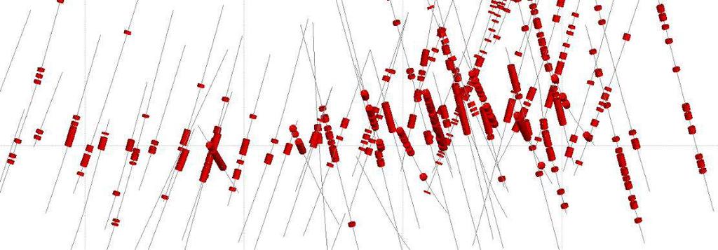
6 Structures and Mineralization Continuity Structural geology may directly control the style and continuity of mineralization. Blast hole gold assays Intersection pattern, kinematics and fluid permeability (fault zone properties)


7 Structures and Mineralization Continuity Structure may directly control continuity of the high grade mineralization. Grade continuity should make sense relative to deformation Mineralization can be deformed by Brittle deformation: commonly understood Ductile deformation: Often overlooked


8 Modelling Structural Continuity How did I justify this interpretation? What are the data constraints? Where is the model confident? Resource Geologist Geotechnical Engineer Investor
9 Geology is not straight lines Geological systems are complex with variable properties. How do you communicate this pattern and continuity? West Claims Mine, Ortlepp,1997


10 3-D Modelling Continuity Interpreted continuity has large impact on a resource or on mine stability. How far? Requires understanding of patterns from mapping and tectonic environment. Often comes down to Segmented? How well does it line up?? What is your interpretation confidence? How do you communicate this?
11 Resource Continuity evidence is sufficient to imply but not verify geological and grade or quality continuity. evidence is sufficient to assume geological and grade or quality continuity between points of observation. evidence is sufficient to confirm geological and grade or quality continuity between points of observation. From CIM DEFINITION STANDARDS, 2014
 damage zone around a fault, Murphy & Barnett, 2018 (F) toppling failure associated with steeply dipping fault system, (G) stable slope with favourable oriented folds and rock fabric, (H) 3-D")
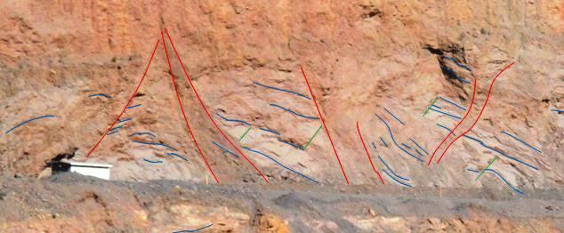
12 Structural Constraints on Geotechnics (A) weak or sheared lithological contact (B) weak foliation, (C) failure on basal fault surface, (D) failure on basal surface with fault tensile release plane, (E) damage zone around a fault, Murphy & Barnett, 2018 (F) toppling failure associated with steeply dipping fault system, (G) stable slope with favourable oriented folds and rock fabric, (H) 3-D perspective with unfavorable fold plunge, Structural deformation patterns and continuity are fundamental input factors in assessing slope failure risks

13 Increasing continuity Structural Continuity on Geotechnics From Sullivan, 2013 Fault zone orientation and continuity can constrain the slope angle

14 The Continuity Problem How can we try constrain continuity?


15 (1) Identify and Describe the Patterns Structural geology is recognition and understanding of patterns Large scale Patterns help define the possible continuity. Map the Patterns!!! Pattern Recognition Small scale Motion tablet 213 / 27


16 Typical Tectonic Structural Patterns Extensional Compressional Strike-slip Combined Patterns Conjugate Riedel
 Global oceanic plate fault system (bottom) NORTH SEA")
17 Fault Network Linked arrays of faults: Basin linkage in the North Sea, off Norway (top right) Main faults in the Pannonian Basin, Hungary (bottom right) Global oceanic plate fault system (bottom) NORTH SEA HUNGARY


18 Realistic Patterns and Continuity Understand real patterns. Look for relationships between different scale structures, as well as crosscutting relationships. Realistic Not realistic


19 3-D Modelling Interpretation of Patterns Modern computer modelling software can import represent structural data in 3-D. 3-D data can be selected and queried on stereonets, to unravel complex patterns. Fold patterns Structural sets Leapfrog Geo TM


20 Fault Heterogeneity - Damage Zones Patterns include zones of complexity. Damages zone commonly occur where faults intersect and/or change orientation. From Peacock et al These zones control mineralizing fluids. The pattern and extent of damage influences mineralization continuity.


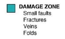
21 Fault Zone Domains How do the damage zone vary along strike and down-dip? Sericite-altered Damage Zone Fault Core Damage Zone


22 (2) Structural Timing / Deformation History Mapping patterns and noting relative timing / cross-cutting relationships help define continuity. Pit mapping typically helps constrain continuity Young Fault


23 Structural Timing / Deformation History Mapping patterns and noting relative timing / cross-cutting relationships help define continuity. 500 m Snap Lake Map - From Barnett, 2013 >


24 Continuity and Brittle Faulting What is the spacing of faults and typical displacement? Post-mineralization faulting can significantly reduce local continuity of the resource. It can also duplicate stratigraphy and mineralization.


25 Ductile Deformation Patterns Impact Continuity 2.1 Ga orogenic belt Relative timing? When does mineralization occur? < 200 ka orogenic belt
26 Continuity and Partitioned Strain


27 Continuity and High Ductile Strain High grade may not have continuity or geometry expected


28 Continuity and Transposition Folded gold, Rainy River Gold project, Ontario. Continuity can be different in different directions and scales


29 Continuity and Transposition Signs of transposition what does this mean on the large-scale? ±10 km


30 Continuity Clues Be careful of continuity!! Quartz veins associated with gold! These veins are deformed, and so is the gold distribution Old Gold S2 S1


31 (3) Surface Traces of Continuity Aerial photographs Aeromagnetic images Surface mapping Orthophotographs Lidar topography lineaments

32 (4) Continuity Evidence from Drillholes clay Clay or alteration Fracture Frequency North Structural Codes Flt, Bx, etc Oriented?! BH / DH assays RQD % shell in Leapfrog


33 (5) Lithological Pattern Changes Lithological offsets and thickness changes Interpreted fault trace along offset

34 (6) Form Line Interpretation Pattern Changes From Geoff Owen, SRK


35 (7) LiDAR Data Continuity Traces Surface or pit LiDAR, photogrammetry and other remote sensing data can help trace continuity. Mapped Faults Fracture Pattern


36 Photogrammetry Continuity Traces Like LiDAR, photogrammetry can help trace continuity. Faults The full trace of a discontinuity is very rarely observed!


37 (8) Geostatistical Geostatistical analysis of sampled rock properties, e.g. assays, can be used to mathematical explore continuity within a geological domain. Grade Estimation Variography used to define estimation search ellipse continuity CIM Conference Montreal 2017

38 (9) Integrated Geological Interpretation Final interpretation of pattern and continuity is built based on all evidence, integrated in 3D.

39 Geological Foundation The single most important factor in Resource/Reserve estimation is an understanding of the geology of the deposit This cannot be emphasized too strongly. Without a sound geological understanding, and a sensible application of that understanding, an estimation exercise becomes merely a mathematical treatment of sample results with no practical value Commonly the potential errors associated with an incorrect or inappropriate geological interpretation are orders of magnitude larger than the potential errors associated with grade estimation. Changes in the fundamental understanding of the geological controls on mineralization can dramatically alter an assessment of tonnage (Stephenson and Vann, 2001)


40 Example Red Lake Northern Miner, January 13, 2016 Phoenix Project Geology, 2013 TR Red Lake Geology D 1 -D 2 Relationships, F2 deposit, 2013 TR


41 Examples Red Lake Evolution of the Litho-structural model, Phoenix Project, 2016 TR The 2016 model benefited from and extra 94,575 m of infilled drilling and 10 km of underground development. Gold mineralization examples, Phoenix Project, 2016 TR The nature of these uncharacterized faults and their timing relative to gold mineralization is not understood. Rubicon Phoenix 2013 Technical Report
42 Conclusions Continuity is important for geological resources and geotechnical studies. One of the best tools for understanding continuity is structural geology, which constrains possible interpretations and often brings realistic expectations back into a geological model. Modern 3-D modelling tools and the ability to integrate multiple old and new technologies into one decision making environment also helps improve interpretation of continuity. IF founded on Sound Geological Understanding

43 This presentation is protected by copyright vested in SRK Consulting (Canada) Inc. Neither the entire presentation or any part therein, including any images, graphs or tables, may be reproduced or transmitted in any form or by any means whatsoever to any person without the written permission of the copyright holder. This presentation is for informational purposes only and is not the provision of a professional service. SRK accepts no responsibility for any liability which may arise from reliance upon the contents of this presentation. Thank you Wayne Barnett, PhD, PrSciNat. wbarnett@srk.com
Pahtavaara Drill Program Intersects 32.8 G/T Gold Over 2.0M And 2.1 G/T Gold Over 18.0M In The Karoliina Zone
 Page 1 of 6 a Pahtavaara Drill Program Intersects 32.8 G/T Gold Over 2.0M And 2.1 G/T Gold Over 18.0M In The Karoliina Zone Jan 11, 2017 Toronto, Ontario, Canada Listed: RUP-TSX-V January 10, 2017 Rupert
Deformation: Modification of Rocks by Folding and Fracturing
 CHAPTER 7 Deformation: Modification of Rocks by Folding and Fracturing Chapter Summary A geologic map is a scientific model of rock formations that are exposed on the Earth s surface showing outcrops,
Mine Scale Constrained Geophysical Inversion; A Case Study at the Darlot-Centenary Gold Mine
 Page 1 Mine Scale Constrained Geophysical Inversion; A Case Study at the Darlot-Centenary Gold Mine Sarah Monoury, SRK Consulting, Ben Jupp, SRK Consulting and Andrew Foley, Gold Fields This article was
Application of Core Logging Data to generate a 3D Geotechnical Block Model
 Application of Core Logging Data to generate a 3D Geotechnical Block Model Engineering Geology and Innovation: Research Infrastructure - Sustainable Development (I.A.E.G) Eleftheria Vagkli, M.Sc. Senior
Chapter 15 Structures
 Chapter 15 Structures Plummer/McGeary/Carlson (c) The McGraw-Hill Companies, Inc. TECTONIC FORCES AT WORK Stress & Strain Stress Strain Compressive stress Shortening strain Tensional stress stretching
Chapter 10: Deformation and Mountain Building. Fig. 10.1
 Chapter 10: Deformation and Mountain Building Fig. 10.1 OBJECTIVES Describe the processes of rock deformation and compare and contrast ductile and brittle behavior in rocks. Explain how strike and dip
Radial basis functions and kriging a gold case study
 Page Radial basis functions and kriging a gold case study D Kentwell, Principal Consultant, SRK Consulting This article was first published in The AusIMM Bulletin, December. Introduction Recent advances
AUGUSTINE VENTURES ANNOUNCES HIGH GRADE GOLD BEARING TENSION VEINS IN THE HANGING WALL OF THE SURLUGA DEPOSIT
 NEWS RELEASE November 29, 2016 AUGUSTINE VENTURES ANNOUNCES HIGH GRADE GOLD BEARING TENSION VEINS IN THE HANGING WALL OF THE SURLUGA DEPOSIT Toronto, Ontario November 29, 2016 - The Manager, Red Pine Exploration
Rockstar Gold Property Goudreau-Dog Lake Area, Wawa, Ontario. Argo Gold Inc. (ARQ)
") Rockstar Gold Property Goudreau-Dog Lake Area, Wawa, Ontario Argo Gold Inc. (ARQ) Location Map, Rockstar Gold Property Land Tenure, Rockstar Gold Property Regional Geology Michipicoten Greenstone Belt
Rockstar Gold Property Goudreau-Dog Lake Area, Wawa, Ontario Argo Gold Inc. (ARQ) Location Map, Rockstar Gold Property Land Tenure, Rockstar Gold Property Regional Geology Michipicoten Greenstone Belt
Rubicon Minerals Provides an Updated Preliminary Interpretation of the Structural Geology of the F2 Gold Deposit
 TSX: RMX OTCQX: RBYCF Rubicon Minerals Provides an Updated Preliminary Interpretation of the Structural Geology of the F2 Gold Deposit TORONTO, Ontario, March 12, 2018 Rubicon Minerals Corporation (TSX:
MONETA INTERCEPTS g/t GOLD INCLUDING g/t GOLD AND g/t GOLD INCLUDING g/t GOLD AT SOUTH WEST
 NEWS RELEASE 15/2018 Symbol: TSX: ME FOR IMMEDIATE RELEASE MONETA INTERCEPTS 5.30 m @ 7.63 g/t GOLD INCLUDING 0.80 m @ 22.40 g/t GOLD AND 7.13 m @ 5.06 g/t GOLD INCLUDING 1.98 m @ 12.47 g/t GOLD AT SOUTH
Fault Architecture, Associated Structures and Uranium Mineralization, Eastern Athabasca Basin: A Provisional Empirical Classification
 December 2014 Fault Architecture, Associated Structures and Uranium Mineralization, Eastern Athabasca Basin: A Provisional Empirical Classification David Thomas, Alex Aubin, Dan Brisbin, Joshua Mukwakwami,
Two Gold Properties for Option, Northwestern Ontario
 1 Two Gold Properties for Option, Northwestern Ontario My two grassroots gold exploration properties located about 60-70 km southwest of Pickle Lake, northwestern Ontario. The properties are located near
Crags, Cracks, and Crumples: Crustal Deformation and Mountain Building
 Crags, Cracks, and Crumples: Crustal Deformation and Mountain Building Updated by: Rick Oches, Professor of Geology & Environmental Sciences Bentley University Waltham, Massachusetts Based on slides prepared
Evaluation of Mineral Resource risk at a high grade underground gold mine
 Evaluation of Mineral Resource risk at a high grade underground gold mine Presented by: Aaron Meakin Manager Corporate Services CSA Global 21 August 2015 Project Background Beaconsfield Gold Mine, Tasmania
MONETA INTERCEPTS g/t GOLD INCLUDING g/t GOLD AT SOUTH WEST
 NEWS RELEASE 13/2018 Symbol: TSX: ME FOR IMMEDIATE RELEASE MONETA INTERCEPTS 25.00 m @ 2.48 g/t GOLD INCLUDING 4.50 m @ 5.00 g/t GOLD AT SOUTH WEST Toronto, Ontario September 13, 2018 - Moneta Porcupine
TECTONIC AND STRUCTURAL CONTROLS ON INTRUSION- RELATED DEPOSITS IN THE NORTHERN PART OF SREDNA GORA ZONE, BULGARIA NIKOLAY PETROV & KAMELIA NEDKOVA
 TECTONIC AND STRUCTURAL CONTROLS ON INTRUSION- RELATED DEPOSITS IN THE NORTHERN PART OF SREDNA GORA ZONE, BULGARIA NIKOLAY PETROV & KAMELIA NEDKOVA INVESTIGATED AREA Praveshka Lakavica deposit Elatsite
Sotkamo Silver Ag-Zn-Pb-Au Deposit: Mineral Resource Estimate Update
 Sotkamo Silver Ag-Zn-Pb-Au Deposit: Mineral Resource Estimate Update Jan 15. 2014 By Jyrki Parkkinen Ph.D. Eurogeologist (850) Parkkinen Geoconsulting Jyrki.parkkinen@elisanet.fi LinkedIn Parkkinen: Sotkamo
Marathon s Valentine Lake Property: An Emerging Gold Camp in Eastern Canada
 Marathon s Valentine Lake Property: An Emerging Gold Camp in Eastern Canada Sherry Dunsworth, V.P. Exploration March 3, 2015 Forward Looking Information CAUTIONARY STATEMENT REGARDING FORWARD-LOOKING INFORMATION
Advancing High Grade Gold Assets in Red Lake, Ontario
 Advancing High Grade Gold Assets in Red Lake, Ontario Forward Looking Statement Except for historical information contained herein, this presentation may contain forward-looking statements including but
Summary Overview of PGM Mineralized Zones at the North End of the River Valley Deposit near Sudbury, Ontario
 Summary Overview of PGM Mineralized Zones at the North End of the River Valley Deposit near Sudbury, Ontario Technical Presentation Dr. Bill Stone Principal Consulting Geoscientist Toronto March 2017 Claims
HY LAKE GOLD INTERSECTS 1.0 METRES OF GRAMS PER TONNE GOLD FROM ROWAN PROPERTY ROWAN MINE SYSTEM STRIKE LENGTH EXTENDED TO MINIMUM 800m
 NES ELEASE CNSX: YL FANKFT: YK Y LAKE GOLD INTESECTS. METES OF 4.5 GAMS PE TONNE GOLD FOM OAN POPETY OAN MINE SYSTEM STIKE LENGT EXTENDED TO MINIMM 8m FO IMMEDIATE ELEASE, February 6, Toronto, Ontario.
Stress and Strain. Stress is a force per unit area. Strain is a change in size or shape in response to stress
 Geologic Structures Geologic structures are dynamically-produced patterns or arrangements of rock or sediment that result from, and give information about, forces within the Earth Produced as rocks change
Lecture 9 faults, folds and mountain building
 Lecture 9 faults, folds and mountain building Rock deformation Deformation = all changes in size, shape, orientation, or position of a rock mass Structural geology is the study of rock deformation Deformation
Crustal Deformation Earth - Chapter Pearson Education, Inc.
 Crustal Deformation Earth - Chapter 10 Structural Geology Structural geologists study the architecture and processes responsible for deformation of Earth s crust. A working knowledge of rock structures
Faults, folds and mountain building
 Faults, folds and mountain building Mountain belts Deformation Orogens (Oro = Greek all changes for mountain, in size, shape, genesis orientation, = Greek for or formation) position of a rock mass Structural
NEWS RELEASE FULLER PROPERTY CONTINUES TO DELIVER GOOD RESULTS 2.53 GRAMS PER TONNE GOLD OVER METRES
 NEWS RELEASE FULLER PROPERTY CONTINUES TO DELIVER GOOD RESULTS 2.53 GRAMS PER TONNE GOLD OVER 122.7 METRES March 1, 2012, Toronto, Ontario, Canada: Lexam VG Gold Inc. (TSX: LEX), (FRANKFURT: VN3A), (OTCQX:
Evaluation of Structural Geology of Jabal Omar
 International Journal of Engineering Research and Development e-issn: 2278-067X, p-issn: 2278-800X, www.ijerd.com Volume 11, Issue 01 (January 2015), PP.67-72 Dafalla Siddig Dafalla * and Ibrahim Abdel
Geomechanical Modelling of the Mount Isa Copper Deposit
 Geomechanical Modelling of the Mount Isa Copper Deposit John G McLellan 1, 2, Rhonda O Sullivan 3, Brad Miller 4, Daniel Taylor 5 1. Principal Geoscience Consultant, GMEX, John@gmex.com.au. 2. Adjunct
Assessment of rock slope stability using remote sensing technique in the Gold Coast area, Australia
 Assessment of rock slope stability using remote sensing technique in the Gold Coast area, Australia Author Gratchev, Ivan, Shokouhi, A., Kim, Dong Hyun, Stead, D., Wolter, A. Published 2013 Conference
Satulinmäki Au Prospect Structural Mapping
 M19/2024/2003/1/10 Juhani Ojala Satulinmäki Au Prospect Structural Mapping V. Juhani Ojala Geological Survey of Finland 1 Table of Contents Introduction...2 Local geology...2 Structures...2 Discussion...2
Uncovering The Riches of the Abitibi Greenstone Belt of Canada
 1 TSX.V: ALZ June 2016 Uncovering The Riches of the Abitibi Greenstone Belt of Canada The Haultain Gold Discovery The Abitibi Greenstone Belt & Gold 170+ million oz of gold produced to date from more than
Mishi Lake Gold Property Mishibishu Lake Area, Wawa
 Mishi Lake Gold Property Mishibishu Lake Area, Wawa Location, Accessibility, Infrastructure and Local Resources The property is located 40 km west of Wawa, Ontario, in the Mishibishu Lake Area, Sault Ste.
Reservoir Geomechanics and Faults
 Reservoir Geomechanics and Faults Dr David McNamara National University of Ireland, Galway david.d.mcnamara@nuigalway.ie @mcnamadd What is a Geological Structure? Geological structures include fractures
Red Pine Releases Inferred Resource Report Improves Grade and Tonnage for Wawa Gold Project
 NEWS RELEASE June 11, 2015 Red Pine Releases Inferred Resource Report Improves Grade and Tonnage for Wawa Gold Project Toronto, Ontario June 11, 2015 Red Pine Exploration Inc. (TSX-V: RPX) (the Company
Crystalline rocks in the Patterson Lake corridor: implications for uranium deposit genetic models. Colin D. Card
 Crystalline rocks in the Patterson Lake corridor: implications for uranium deposit genetic models Colin D. Card Acknowledgements Forum Uranium Purepoint Uranium Fission Uranium Geological Survey of Canada
Structural Evolution of the Keno Hill Ag-Pb-Zn mining district, Yukon
 Structural Evolution of the Keno Hill Ag-Pb-Zn mining district, Yukon Simon D. Craggs, David R. Lentz and Joseph C. White Introduction The Keno Hill Ag-Pb-Zn mining district is located in the central Yukon,
Geotechnical Models and Data Confidence in Mining Geotechnical Design
 Geotechnical Models and Data Confidence in Mining Geotechnical Design Michael Dunn Principal Consultant (Geotechnical Engineering) Overview Geotechnical models Geotechnical model and design Data reliability
Faults. Strike-slip fault. Normal fault. Thrust fault
 Faults Strike-slip fault Normal fault Thrust fault Fault any surface or narrow zone with visible shear displacement along the zone Normal fault Strike-slip fault Reverse fault Thrust fault
Azerbaijan International Mining Company Limited
 Updated Mineral Resources Gedabek Mineral Deposit, Republic of Azerbaijan Azerbaijan International Mining Company Limited Prepared by CAE Mining CAE Mining 8585 Cote-de-Liesse Saint-Laurent Quebec H4T
Homestake /Standby Gold Zone Deep Drilling + Down Hole EM Phase 2 Drilling Q2 2019
 www.mineralmtn.com World s Richest BIF Hosted Gold Belt >62 Million ounce North Americas Largest Supergiant Orogenic Gold Province Homestake District South Dakota, USA TSX-V MMV -OTCQB-MNRLF Homestake
Strategic Phase 2 Exploration Program Launched at Island Gold High-Grade Resource Potential Identified Laterally and at Depth
 PRESS RELEASE TSX NYSE MKT: RIC Strategic Phase 2 Exploration Program Launched at Island Gold High-Grade Resource Potential Identified Laterally and at Depth Deep Drilling Intersects 18.63 g/t over 6.60
PROJECT 81 Lucas Gold Deposit 2018 Winter Drilling Program Assay Results
 TSX.V: NOB FWB: NB7 OTC.PK: NLPXF PROJECT 81 Lucas Gold Deposit 2018 Winter Drilling Program Assay Results Toronto, Ontario June 27, 2018 - Noble Mineral Exploration Inc. ( Noble or the "Company") (TSX-V:NOB,
SABINA GOLD &SILVER REPORTS COMPLETION OF DRILLING AT ECHO DEPOSIT, BACK RIVER, NUNAVUT.
 202-930 West First Street, North Vancouver, B.C. 604.998.4175 July 31, 2014 SBB NR-14-10 SBB TSX SABINA GOLD &SILVER REPORTS COMPLETION OF DRILLING AT ECHO DEPOSIT, BACK RIVER, NUNAVUT. 2014 Drilling confirms
Queenston intersects Contact Zone on the Pandora Property and new gold zones in Kirkland Lake
 1 Queenston intersects Contact Zone on the Pandora Property and new gold zones in Kirkland Lake TORONTO, Ontario, March 7, 2003. Queenston Mining Inc. (QMI-TSX) reports diamond drill results on its 100%
Structural Geology and Geology Maps Lab
 Structural Geology and Geology Maps Lab Mesa College Geology 101 Lab Ray Rector: Instructor Structural Geology Lab Pre-Lab Resources Pre-Lab Internet Links 1) Fundamentals of Structural Geology 2) Visualizing
Introduction and Background
 Introduction and Background Itasca Consulting Group, Inc. (Itasca) has been participating in the geomechanical design of the underground 118-Zone at the Capstone Minto Mine (Minto) in the Yukon, in northwestern
3. GEOLOGY. 3.1 Introduction. 3.2 Results and Discussion Regional Geology Surficial Geology Mine Study Area
 3. GEOLOGY 3.1 Introduction This chapter discusses the baseline study of the geology and mineralization characteristics of the mine study area. The study consolidates existing geological data and exploration
MEMO. TO: Dennis Lapoint CC: FROM: Eriaan Wirosono DATE: April, 20 th 2014 SUBJECT: Exploration activity report March-April 2014_EW
 TO: Dennis Lapoint CC: FROM: Eriaan Wirosono DATE: April, 20 th 2014 SUBJECT: Exploration activity report March-April 2014_EW MEMO 1. Highlights and Productivity Overview pan sampling on target Areas 1
West Pender Street Vancouver, BC V6C 2V6 Tel: Fax: TSX-V: GBR NEWS RELEASE
 1020 800 West Pender Street Vancouver, BC V6C 2V6 Tel: 604-646-8354 Fax: 604-646-4526 TSX-V: GBR NEWS RELEASE Great Bear Drills Hinge Zone Extensions - Results Include New 42 m Wide Zone with Multiple
Lecture Outline Friday March 2 thru Wednesday March 7, 2018
 Lecture Outline Friday March 2 thru Wednesday March 7, 2018 Questions? Lecture Exam Friday March 9, 2018 Same time, Same room Bring Pencils and WSU ID 50 question Multiple Choice, Computer Graded Interlude
GLY 155 Introduction to Physical Geology, W. Altermann. Press & Siever, compressive forces. Compressive forces cause folding and faulting.
 Press & Siever, 1995 compressive forces Compressive forces cause folding and faulting. faults 1 Uplift is followed by erosion, which creates new horizontal surface. lava flows Volcanic eruptions cover
PETROLEUM GEOSCIENCES GEOLOGY OR GEOPHYSICS MAJOR
 PETROLEUM GEOSCIENCES GEOLOGY OR GEOPHYSICS MAJOR APPLIED GRADUATE STUDIES Geology Geophysics GEO1 Introduction to the petroleum geosciences GEO2 Seismic methods GEO3 Multi-scale geological analysis GEO4
NEWS RELEASE LATEST EXPLORATION PROGRAM CONTINUES TO DEMONSTRATE NARANJILLO AS A HIGH GRADE SILVER HOST
 555-999 Canada Place Vancouver, BC V6C 3E1 Tel: (604) 687-1717 Fax: (604) 687-1715 www.plminerals.com NEWS RELEASE NOT FOR DISTRIBUTION TO U.S. NEWSWIRE SERVICES OR FOR DISSEMINATION IN THE UNITED STATES
TIGER INTERNATIONAL RESOURCES, INC. (TGR.V) NEWS RELEASE - JUNE 18 th, 2015
 NEWS RELEASE - JUNE 18 th, 2015") TSX-V: TGR US OTC: TGILF TIGER INTERNATIONAL RESOURCES, INC. (TGR.V) NEWS RELEASE - JUNE 18 th, 2015 POSITIVE DRILLING AND TRENCHING RESULTS FROM ITOGON GOLD PROJECT, PHILIPPINES TIGER INTERNATIONAL RESOURCES,
TSX-V: TGR US OTC: TGILF TIGER INTERNATIONAL RESOURCES, INC. (TGR.V) NEWS RELEASE - JUNE 18 th, 2015 POSITIVE DRILLING AND TRENCHING RESULTS FROM ITOGON GOLD PROJECT, PHILIPPINES TIGER INTERNATIONAL RESOURCES,
Geologic Considerations of Shallow SAGD Caprock; Seal Capacity, Seal Geometry and Seal Integrity, Athabasca Oilsands, Alberta Canada
 Geologic Considerations of Shallow SAGD Caprock; Seal Capacity, Seal Geometry and Seal Integrity, Athabasca Oilsands, Alberta Canada Gordon T. Stabb, Michael Webb Durando Resources Corp, Suncor Energy
News Release. Infill Drilling Program
 TSX:RMX NYSE.MKT:RBY News Release January 7, 2015 Rubicon s Infill Drilling Program Confirms Continuity and Grade of the F2 Deposit and Continues to Encounter High-Grade Mineralization in Sparsely Drilled
For personal use only
 ASX ANNOUNCEMENT / MEDIA RELEASE ASX: ABU 21 st September 2015 Operational Update from the Old Pirate Gold Mine and the Coyote Processing Plant ABM Resources NL ( ABM or the Company ) is pleased to announce
Deformation of Rocks. Orientation of Deformed Rocks
 Deformation of Rocks Folds and faults are geologic structures caused by deformation. Structural geology is the study of the deformation of rocks and its effects. Fig. 7.1 Orientation of Deformed Rocks
GEOL 321 Structural Geology and Tectonics
 GEOL 321 Structural Geology and Tectonics Geology 321 Structure and Tectonics will be given in Spring 2017. The course provides a general coverage of the structures produced by brittle and ductile rock
LAB 1: ORIENTATION OF LINES AND PLANES
 LAB 1: ORIENTATION OF LINES AND PLANES Read the introductory section, chapter 1, pages 1-3, of the manual by Rowland et al (2007) and make sure you understand the concepts of bearing, strike, dip, trend,
Using An Introduction to Structural Methods - An Interactive CD-ROM - In and Out of the Classroom
 Using An to Structural Methods - An Interactive CD-ROM - In and Out of the Classroom Tekla A. Harms, Amherst College taharms@amherst.edu H. Robert Burger, Smith College rburger@email.smith.edu TYPE OF
New High Grade Gold-Copper Extensions At Mutiny s Deflector Deposit Highlight Project s Significant Growth Potential
 ASX/Media Release P. (08) 9368 2722 F. (08) 9367 9043 E. mgl@mutinygold.com.au 18 March 2011 New High Grade Gold-Copper Extensions At Mutiny s Deflector Deposit Highlight Project s Significant Growth Potential
Yellowknife Gold Project
 Yellowknife Gold Project This presentation contains forward-looking statements within the meaning of Canadian securities legislation. All statements, other than statements of historical fact, that address
Orezone s Bomboré Gold Project Reaches World Class Size
 Orezone s Bomboré Project Reaches World Class Size Measured and Indicated Mineral Resources up 160% and grade up 27% August 27, 2012- Orezone Corporation ( ORE: TSX ) is pleased to announce that gold mineral
Assay Results Highlights (as of November 16, 2017) representing approximately 4,500 metres ( m ) of drilling:
 representing approximately 4,500 metres ( m ) of drilling:") TSX: RMX OTCQX: RBYCF Rubicon Minerals Provides Additional Drill Results and Observations from its 2017 Exploration Program and Commences Exploratory Underground Development TORONTO, Ontario, November
TSX: RMX OTCQX: RBYCF Rubicon Minerals Provides Additional Drill Results and Observations from its 2017 Exploration Program and Commences Exploratory Underground Development TORONTO, Ontario, November
KIRKLAND LAKE GOLD EXPANDS NEW HIGH-GRADE ZONE BELOW TAYLOR MINE, REPORTS MINERALIZED EXTENSIONS ALONG STRIKE AND AT DEPTH
 KIRKLAND LAKE GOLD EXPANDS NEW HIGH-GRADE ZONE BELOW TAYLOR MINE, REPORTS MINERALIZED EXTENSIONS ALONG STRIKE AND AT DEPTH New gold zone intersected 500 metres ( m ) below existing mining and mine infrastructure
New Drilling Program Commences at Mutiny s Deflector Deposit
 New Drilling Program Commences at Mutiny s Deflector Deposit Drilling Program Highlights 12,000 metre RC and diamond drilling program underway New drilling program targets strike extensions in the Northern
MINERAL MOUNTAIN RESOURCES LTD. MMV.TSX-V
 MINERAL MOUNTAIN RESOURCES LTD. 201-1416 West 8 th Avenue Vancouver, B.C. V6H 1E1 T: 604-714-0111 F: 604-714-1119 MMV.TSX-V NEWS RELEASE March 3, 2011 No. 2011-04 MINERAL MOUNTAIN DRILLS 3.17 g/t OVER
Tricks to Creating a Resource Block Model. St John s, Newfoundland and Labrador November 4, 2015
 Tricks to Creating a Resource Block Model St John s, Newfoundland and Labrador November 4, 2015 Agenda 2 Domain Selection Top Cut (Grade Capping) Compositing Specific Gravity Variograms Block Size Search
The Stability Of Fault Systems In The South Shore Of The. St. Lawrence Lowlands Of Québec Implications For Shale Gas Development
 The Stability Of Fault Systems In The South Shore Of The St. Lawrence Lowlands Of Québec Implications For Shale Gas Development John Brodylo, Jean-Yves Chatellier,Guillaume Matton & Michel Rheault Copyright
Ongoing Drilling of Kiena Deep a Zone Confirms Multiple High Grade Lenses and Extends Zone Down Dip
 Ongoing Drilling of Kiena Deep a Zone Confirms Multiple High Grade Lenses and Extends Zone Down Dip TORONTO, May 17, 2018 (GLOBE NEWSWIRE) -- Wesdome Gold Mines Ltd. (TSX:WDO) ( Wesdome or the Company
Amador Canyon Silver Mining Property Lander County, NV
 Amador Canyon Silver Mining Property Lander County, NV Over $1 million worth of exploration and evaluation work performed Favorable drill results including a return of 286 g/ton silver over 12.2 meters
FOCUS MINERALS REPORTS ENCOURAGING FIRST ROUND RESULTS FROM COOLGARDIE NEAR MILL PROGRAMME
 ASX ANNOUNCEMENT 28 March 2013 FOCUS MINERALS REPORTS ENCOURAGING FIRST ROUND RESULTS FROM COOLGARDIE NEAR MILL PROGRAMME Focus Minerals Ltd. (ASX: FML) is pleased to announce the first round of results
Course Title: Discipline: Geology Level: Basic-Intermediate Duration: 5 Days Instructor: Prof. Charles Kluth. About the course: Audience: Agenda:
 Course Title: Structural Geology Discipline: Geology Level: Basic-Intermediate Duration: 5 Days Instructor: Prof. Charles Kluth About the course: This course covers the basic ideas of structural geometry
Toronto, Canada March 4, 2013
 NEWS RELEASE SAS REPORTS ADDITIONAL DRILLING RESULTS FOR THE HISLOP NORTH AND SMOKE DEEP ZONES AND SIGNIFICANT INITIAL RESULTS FROM THE HISLOP PIT COMPLEX AND NEW SEDIMENT ZONE AT THE HOLLOWAY MINE Hislop
Summary of Rover Metals Geologic Mapping Program at the Up Town Gold Project, Northwest Territories
 October 13, 2017 Summary of Rover Metals Geologic Mapping Program at the Up Town Gold Project, Northwest Territories Vancouver, British Columbia, Canada - Rover Metals Corp., Rover, is pleased to provide
rock mass structure characteristics accurate and precise
 Introduction Geotechnical data provides information on rock mass and structure characteristics which will be relied upon for slope and underground design at the Back River deposits. It is important that
Interactive 3D Sketchupbook
 THE UNIVERSITY OF SYDNEY - SCHOOL OF GEOSCIENCES Interactive 3D Sketchupbook Patrice F. Rey CHAPTER 1 Orienting Planes and Lines 1 Interactive 1.1 Strike, dip and dip direction In a 3D space, planar surfaces
Aurion Provides Update on 2018 Drill Program and Reports High Grade Gold Results...
 Page 1 of 5 News 2018 Aurion Provides Update on 2018 Drill Program and Reports High Grade Gold Results at A2 and Aamurusko Northwest Aug 17, 2018 Aurion Resources Ltd. (TSX VENTURE:AU) ( Aurion Aurion
A Career Mineral Exploration, Resource and Mining Geology
 1 A Career Mineral Exploration, Resource and Mining Geology Presenter: Ben Lepley Location: BGS, Keyworth My Journey so Far 2 Love of mountains Geology A Level BSc/MESci in Geology (no specialisation)
Queensland Mining Corporation Limited
 Queensland Mining Corporation Limited ABN 61 109 962 469 ASX Release 29 th July 2011 Drilling Commenced at Duck Creek Copper-Gold Project, Cloncurry, North-west Queensland Highlights RC drilling has commenced
GOLD IN MANITOBA SHORT COURSE
 November 20-22 GOLD IN MANITOBA SHORT COURSE D. Lentz Developing the Orogenic Gold Deposit Model: Insights from R&D for Exploration Success View Abstract B. Lafrance Structural Controls on Hydrothermal
Bosl/Brac _Arnot_Gumeni Undermining Study_Stage1_InterimFinal_ docx
 SRK Consulting: 453803: Arnot to Gumeni High Voltage Lines-Stage 1 Undermining Study (Interim) Pagee 7 Figure 4-4 Geological map showing Stratigraphy in relation to proposed routes Bosl/Brac 453803_Arnot_Gumeni
CSA Mine Observations Applied to the Development of Regional Exploration Models
 CSA Mine Observations Applied to the Development of Regional Exploration Models 1 Introduction Recent work completed by the geology team has resulted in an improved understanding of the CSA mine system
Geo-hazard Potential Mapping Using GIS and Artificial Intelligence
 Geo-hazard Potential Mapping Using GIS and Artificial Intelligence Theoretical Background and Uses Case from Namibia Andreas Knobloch 1, Dr Andreas Barth 1, Ellen Dickmayer 1, Israel Hasheela 2, Andreas
A B C PAD A HIGHLIGHTS
 Murchison Minerals Intercepts 12.30% Zinc, 0.70% Copper, 0.18% Lead and 42.03 g/t Silver 14.97% ZnEq over 6.37 Metres and Extends Known Limits of Brabant McKenzie VMS Deposit June 25, 2018 (Toronto, Ontario):
MANN SILVER-COBALT MINE. PORE: TSXV PowerOre.com
 MANN SILVER-COBALT MINE PORE: TSXV PowerOre.com FORWARD LOOKING STATEMENTS We are in the mineral exploration and development business. It is inherently risky, and all potential investors should be keenly
Kalman Mineral Resource Update
 10 September 2008 The Manager Company Announcements Office stralian Stock Exchange Via Online Electronic Lodgement Kalman Mineral source Update The Directors are pleased to announce an updated mineral
T Boli Gold Mine Exploration Update
 NEWS RELEASE Symbol: RZL-TSX.V T Boli Gold Mine Exploration Update March 28 2018 - Vancouver, British Columbia: Rizal Resources Corporation (TSXV: RZL) ( Rizal or the Company ) announces that it has filed
Lecture 6 Folds, Faults and Deformation Dr. Shwan Omar
 Fold: A fold is a bend or wrinkle of rock layers or foliation; folds form as a sequence of ductile deformation. Folding is the processes by which crustal forces deform an area of crust so that layers of
Drilling highlights include:
 Toro Gold Ltd Trafalgar Court Admiral Park Guernsey GY1 3EL News Release: 10 th July 2018, Guernsey Mako Mine, Senegal Exploration Drilling Update Toro Gold ( Toro Gold or the Company ) is pleased to provide
Orsu Metals completes Phase 2 drilling program and announces significant intercepts in drillhole SDH17-15 at Zone 23, Sergeevskoe Gold Project, Russia
 FOR IMMEDIATE RELEASE TSX-V: OSU January 22, 2018 Orsu Metals completes Phase 2 drilling program and announces significant intercepts in drillhole SDH17-15 at Zone 23, Sergeevskoe Gold Project, Russia
CROCODILE GOLD INTERSECTS 7.1 G/T AU OVER 4.5 METERS INCLUDING 11.2 G/T AU OVER 2.6 METERS AT THE UNION REEFS PROJECT, PROSPECT DEPOSIT
 65 Queen Street West Suite 825, P.O. Box 75 Toronto, Ontario M5H 2M5 Canada CROCODILE GOLD INTERSECTS 7.1 G/T AU OVER 4.5 METERS INCLUDING 11.2 G/T AU OVER 2.6 METERS AT THE UNION REEFS PROJECT, PROSPECT
IMC EXPLORATION GROUP PLC. AVOCA Au-Cu-Zn PROJECT DR BILL SHEPHARD
 IMC EXPLORATION GROUP PLC DR BILL SHEPHARD Figure 2 Introduction Massive Ore, West Avoca West Avoca towards the Goldmines River IMC has recently acquired exploration rights to two licences adjacent to
Preface and Overview. Folded strata in the mountains of Italy (ca AD), Leonardo da Vinci
, Leonardo da Vinci") Preface and Overview Folded strata in the mountains of Italy (ca. 1500 AD), Leonardo da Vinci Models of Mountain Building and Associated Deformation as represented by G.P. Scrope Deformation Feature: Scales
Preface and Overview Folded strata in the mountains of Italy (ca. 1500 AD), Leonardo da Vinci Models of Mountain Building and Associated Deformation as represented by G.P. Scrope Deformation Feature: Scales
ASANKO GOLD ANNOUNCES ENCOURAGING INITIAL DRILL RESULTS FROM NEW EXPLORATION TARGET
 PRESS RELEASE ASANKO GOLD ANNOUNCES ENCOURAGING INITIAL DRILL RESULTS FROM NEW EXPLORATION TARGET Highlights: Highly encouraging results from new near-mine exploration target, Akwasiso 10,000 metres of
Premier Updates Mercedes Mine Exploration Over 45,000 Metres Drilled During the Year
 Press Release Thunder Bay: January 03, 2018 Premier Updates Mercedes Mine Exploration Over 45,000 Metres Drilled During the Year PREMIER GOLD MINES LIMITED ( Premier or The Company ) (TSX:PG) is pleased
McVicar Lake Gold Property Lang Lake Greenstone Belt Ontario. Argo Gold Inc. (ARQ)
") McVicar Lake Gold Property Lang Lake Greenstone Belt Ontario Argo Gold Inc. (ARQ) Forward Looking Statements This presentation may contain forward-looking statements that involve a number of risks and
McVicar Lake Gold Property Lang Lake Greenstone Belt Ontario Argo Gold Inc. (ARQ) Forward Looking Statements This presentation may contain forward-looking statements that involve a number of risks and
For personal use only
 20 16 FEBRUARY JANUARY 2017 ASX ANNOUNCEMENT OMMANEY FOLLOW-UP RC DRILLING Ommaney follow up drilling to commence in early to mid-march 2017. A 7 hole RC drilling program will follow up the intense alteration