Phil Flentje. in collaboration with Industry Partners Wollongong City Council Roads and Traffic Authority Rail Corporation HAZARD AND RISK
|
|
|
- Blanche Freeman
- 6 years ago
- Views:
Transcription
 Civil, Mining,")


1 Dr. Phil Flentje, Senior Research Fellow (Engineering Geologist) Civil, Mining, and Environmental Engineering GIS-based Landslide Inventory, Susceptibility and Hazard zoning capability Dr Phil Flentje University of Wollongong, NSW, AUSTRALIA in collaboration with Industry Partners Wollongong City Council Roads and Traffic Authority Rail Corporation Phil Flentje LANDSLIDE HAZARD AND RISK GIS Faculty PERFORMANCE of Engineering g MANAGEMENT TECHNIQUES University of Wollongong 1 pflentje@uow.edu.au
2 Discussion Issues Illawarra GIS - based Landslide Inventory What the LI tells us Growing into the Sydney Basin LI Landslide Susceptibility Modelling - Wollongong LGA (technical bits and results) Sydney Basin wide Landslide Inventory and the proof of concept SB Landslide Susceptibility zoning A composite National Landslide Inventory Conclusions 2
3 UoW Illawarra Landslide Inventory Please refer to paper Developed from 1993, now quite mature but have perhaps 80% Field mapping - 1:4000 scale and since with DGPS, GIS AP/ALS Comprehensive relational MS Access and ESRI Geo-database 3
4 UoW Illawarra Landslide Inventory Thirroul to Wombarra area Austinmer Cross Section ,000 M 1,500 2,000 Next slide 4
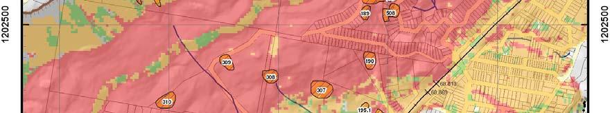
5 Site 113 5


6 So, what does this Inventory tell us about landsliding within Wollongong? In summary 615 landslide locations, over 1000 events includes first time movements, also multiple recurrences at some sites, some meaningful frequency info 615 landslides comprise 52 falls, 49 flows and 501 slides according to the Cruden and Varnes 1996 classifications system + a few unclassified Volumes <1m 3 up to 720,000m 3, average 21,800m 3 In the 188 km 2 model area, 2.37% of the ground surface is affected by landslides to people killed 51 houses damaged, 30 destroyed Costs are very poorly documented and understood GA is working on this 6
7 Landslide Susceptibility Modeling Definition - quantitative or qualitative assessment of the classification, volume and spatial distribution of landslides in an area AGS 2007 (a) LI shows this must be done for independently for slide, fall and flow category landslides - the rest of this presentation focuses on slide category landslides Knowledge-based Data Mining modeling within GIS framework Datasets: Landslide Inventory Geology Vegetation 1976 contour based DEM - 10m pixel res (Qtn: what is the best resolution to use???) DEM derivatives (slope, aspect, curvatures, Terrain Classification, Flow Accumulation and the Wetness Index) Scheduled for refinement now with an ALS generated DEM, more landslides 7
8 Susceptibility knowledge based modeling process 8
9 Segment of the text file used for See5 Data Mining Data mining rule set generated for the training data ie, all landslide pixels plus an equal number of non landslide random pixels (65,295 points) X Y Z flowacc wetness ras10ma ras10ms plancur slide geology Vegetat profile curvatu geom_
10 Data in 10
11 3 example rules of 40 in rule set Rule ue3:( (22) flowacc <= 0 aspect > slope > 9.5 geology {3, { } 15, 16, 17} uowvege {6, 7} -> class 0 [0.958] Rule 24: (590/89) aspect <= 78.8 slope > 9.5 geology = 17 uowvege {4, 8, 16} -> class 1 [0.848] Rule 26: (1629/265) slope > 9.5 plaincur <= geology {3, 5, 6, 8-17, 19} uowvege {4, 8, 16} -> class 1 [0.837] Data Mining Rules Data Mining rules are generated to define all attributed training data in layman's terms DM is simply pattern recognition The Model contains a defined number of rules. Example rules are shown to the left. Each rule is ranked kdwith iha confidence factor, after repeated evaluation and validation, by the Laplace Ratio (nm+1)/(n+2) where n is the number of training cases that a specific rule correctly recognises, and m if it appears, is the number of cases that do not belong to the class predicted by the rule., i.e. rule x: (n/m). Class 0 is no landslide, 1 is landslide Rule sets then applied to Entire Model Area using ESRI Model Builder Confidence value as it aplies to each pixel is then mapped as susceptibility distribution 11
12 ESRI Model Builder used to re-apply rules within ArcGIS Illawarra 10m Model Now developing Python script to automate this process 12
13 The resulting Susceptibility Grid Next screen Getting the model is one step in this process But how do you categorize or differentiate zones in this model Will these zones and stats be meaningful to compare to other zones in adjacent regions, let alone elsewhere nationally and internationally? If not, what s the point? 13
14 Susceptibility Class High Moderate Low Very Low Percent ntage of data a (%) High Susceptibility Zone 60.3% of all known landslides 10.8% of study area 8.12% of zone affected by landslides (0.73) All Slide Pixels (29,480 'Training' Pixels) Low Susceptibility Zone 3.3% of all known landslides 6.4% of study area 0.85% of zone affected by landslides Moderate Susceptibility Zone 32.3% of all known landslides 11.9% of study area 4.12% of zone affected by landslides -(0.345) (-0.46) Very Low Susceptibility Zone 4.1% of all known landslides 70.9% of study area 0.09% of zone affected by landslides Determining All Study Area pixels (1.88 million pixels) 0 Zones Data Mining Confidence Value


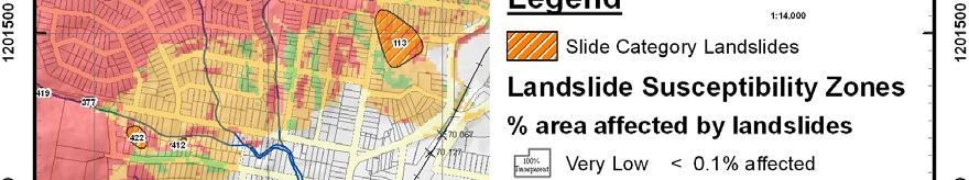
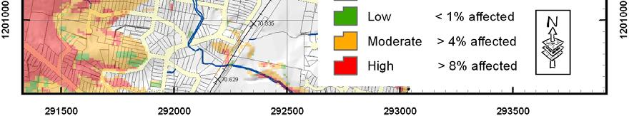
15 Susceptibility Zones 15
16 Susceptibility Summary Legend Landslide Susceptibility Zones Sus. Class - % area affected by slides Very Low ~ 0.1% affected Low < 1% affected Moderate > 4% affected High > 8% affected Statistics of Susceptibility Model Area (188 Square Kms) 16
17 Hazard Description Regional Landslide Hazard Hazard - a condition with the potential to cause an undesirable consequence. Should also include location, volume, classification, velocity and probability Now that some reasonable zones have been defined this all becomes entirely possible, particularly with the aid of the GIS and various zone distributions. Map Colour % of Zone affected by Slides (S) Zone area as % of Study Area (Sa) % of Total Slide Population in Hazard Zone (Sp) Landslide Annual Average Frequency ( ) Relative Susceptibility of Zone (S/Stotal) = Sr Relative Annual Likelihood (Hazard) Zone (Sp) ( ) ( ) (Sr/T) Maximum Landslide Volume (m³) Average Landslide Volume (m³) ( ) ( ) Weighted (volume) Hazard Very Low E E E-05 36,300 3, E-04 Low E E E-04 4,700 1, E-03 Moderate E E E-03 45,000 5, E-02 High E E E ,000 28, E-01 Landslide Count Volume Range (m 3 ) Count > > >1-3 4 > > > > > > > > > > > > Landslide Volume (m 3 ) 6 Specific Frequency # of events Specific Frequency # of sites ( ) per site Count ( ) Landslide Count Normal Fit Number of data points used = 399 Average Profile Angle = 17 o S tanda rd Deviation = 8 o Landslide Profile Angle basedongisqueryof2mdem
18 Landslide Hazard Zoning 5.84E E E E-03 18
19 Rockfall modelling as well but that s another storey 19


20 Extent of UoW Sydney Basin Landslide Inventory 2006 census shows 4.5 million people in Sydney Basin region UoW Landslide Inventory 586 landslides GA - National Landslide database within Sydney Basin excluding the Illawarra 130 Total 716 landslides Vegetation mapping at least Pittwater LGA also has 220 landslides + SCCG etc collaboration may add more 20
21 ESRI Model Builder used to re-apply rules within ArcGIS Sydney Basin Model shown 21
22 22


23 Composite National Landslide Inventory MRT 1584 landslides SW Victorian landslides GA s Australian LI 492 landslides Wollongong UoW LI 586 Warragamba Area from S. Greene PhD in SA & hopefully Pittwater Council 223 & possibly even others from wider SCCG ~ roughly 4987 landslides nationally that we know about ~ 4700 are on the eastern seaboard and Tasmania Doesn t include many in Camden Picton Area, Alpine Regions, Parwan Valley and Shire of Yarra Ranges in Victoria etc Recent geomorphic photo interpretation in SW Victoria has identified almost 10,000 areas 23of instability
24 Conclusions The base Landslide Inventory data is the essential first step in this type of work and its compilation requires sound and thorough engineering i geological lmapping there is no substitute t for this! Repeat, no substitute! the spatial modeling is only possible if the LI exists Knowledge based Data Mining is a sound functional technique to aid development of landslide Susceptibility and Hazard zoning. AGS 2007 now requires this work be done Proven for high resolution, large, regional perhaps even Australia wide applications GIS techniques are only a tool to aid balanced decision making 24
Landslide susceptibility and landslide hazard zoning in Wollongong. University of Wollongong, NSW, AUSTRALIA
 Dr. Phil Flentje, Senior Research Fellow (Engineering Geologist) Civil, Mining, and Environmental Engineering email: pflentje@uow.edu.au Landslide susceptibility and landslide hazard zoning in Wollongong
Practical reliability approach to urban slope stability
 University of Wollongong Research Online Faculty of Engineering - Papers (Archive) Faculty of Engineering and Information Sciences 2011 Practical reliability approach to urban slope stability R. Chowdhury
Landslide Susceptibility and Hazard derived from a Landslide Inventory using Data Mining an Australian case study
 University of Wollongong Research Online Faculty of Engineering - Papers (Archive) Faculty of Engineering and Information Sciences 2007 Landslide Susceptibility and Hazard derived from a Landslide Inventory
Quantitative landslide hazard assessment in an urban area
 University of Wollongong Research Online Faculty of Engineering and Information Sciences - Papers: Part A Faculty of Engineering and Information Sciences 1999 Quantitative landslide hazard assessment in
Slope instability, hazard and risk associated with a rainstorm event - a case study
 University of Wollongong Research Online Faculty of Engineering and Information Sciences - Papers: Part A Faculty of Engineering and Information Sciences 2000 Slope instability, hazard and risk associated
1. INTRODUCTION, AIMS AND SCOPE
 1. INTRODUCTION, AIMS AND SCOPE 1.1 INTRODUCTION This thesis is concerned with the study of slope instability on the Illawarra Escarpment slopes in the northern half of the Wollongong City Council (WCC)
PROANA A USEFUL SOFTWARE FOR TERRAIN ANALYSIS AND GEOENVIRONMENTAL APPLICATIONS STUDY CASE ON THE GEODYNAMIC EVOLUTION OF ARGOLIS PENINSULA, GREECE.
 PROANA A USEFUL SOFTWARE FOR TERRAIN ANALYSIS AND GEOENVIRONMENTAL APPLICATIONS STUDY CASE ON THE GEODYNAMIC EVOLUTION OF ARGOLIS PENINSULA, GREECE. Spyridoula Vassilopoulou * Institute of Cartography
Geo-hazard Potential Mapping Using GIS and Artificial Intelligence
 Geo-hazard Potential Mapping Using GIS and Artificial Intelligence Theoretical Background and Uses Case from Namibia Andreas Knobloch 1, Dr Andreas Barth 1, Ellen Dickmayer 1, Israel Hasheela 2, Andreas
SPATIAL MODELS FOR THE DEFINITION OF LANDSLIDE SUSCEPTIBILITY AND LANDSLIDE HAZARD. J.L. Zêzere Centre of Geographical Studies University of Lisbon
 SPATIAL MODELS FOR THE DEFINITION OF LANDSLIDE SUSCEPTIBILITY AND LANDSLIDE HAZARD J.L. Zêzere Centre of Geographical Studies University of Lisbon CONCEPTUAL MODEL OF LANDSLIDE RISK Dangerous Phenomena
University of Wollongong. Research Online
 University of Wollongong Research Online Faculty of Engineering - Papers (Archive) Faculty of Engineering and Information Sciences 2010 A Comparative Study of Various Data Mining Techniques as applied
Landslide Recognition using LiDAR derived Digital Elevation Models-Lessons learnt from selected Australian examples
 University of Wollongong Research Online Faculty of Engineering - Papers (Archive) Faculty of Engineering and Information Sciences 2010 Landslide Recognition using LiDAR derived Digital Elevation Models-Lessons
Lessons learnt using GIS to map geological hazards following the Christchurch earthquake
 Gerrard, L.C, Herbert J.A & Revell T.A.J (2013) Proc. 19 th NZGS Geotechnical Symposium. Ed. CY Chin, Queenstown Lessons learnt using GIS to map geological hazards following the Christchurch earthquake
Natural Terrain Risk Management in Hong Kong
 Natural Terrain Risk Management in Hong Kong Nick Koor Senior Lecturer in Engineering Geology School of Earth and Environmental Sciences Slope failures in Hong Kong Man-made Slope Failure - 300 landslides
Geotechnical Risks and Management Systems: An FHWA Perspective
 October 13, 2010 2010 STGE Conference Charleston, WV Geotechnical Risks and Management Systems: An FHWA Perspective Silas C. Nichols, PE, Senior Bridge Engineer - Geotechnical Federal Highway Administration
Geotechnical analysis of slopes and landslides: achievements and challenges
 University of Wollongong Research Online Faculty of Engineering - Papers (Archive) Faculty of Engineering and Information Sciences 2010 Geotechnical analysis of slopes and landslides: achievements and
GIS Application in Landslide Hazard Analysis An Example from the Shihmen Reservoir Catchment Area in Northern Taiwan
 GIS Application in Landslide Hazard Analysis An Example from the Shihmen Reservoir Catchment Area in Northern Taiwan Chyi-Tyi Lee Institute of Applied Geology, National Central University, No.300, Jungda
Preparing Landslide Inventory Maps using Virtual Globes
 Introduction: A landslide is the movement of a mass of rock, debris, or earth down a slope, under the influence of gravity. Landslides can be caused by different phenomena, including intense or prolonged
LANDSLIDE RISK ASSESSMENT IN YOSEMITE NATIONAL PARK. Edna Rodriguez December 1 st, 2016 Final Project
 LANDSLIDE RISK ASSESSMENT IN YOSEMITE NATIONAL PARK Edna Rodriguez December 1 st, 2016 Final Project Table of Contents Introduction... 2 Data Collection... 2 Data Preprocessing... 3 ArcGIS Processing...
USING HYPERSPECTRAL IMAGERY
 USING HYPERSPECTRAL IMAGERY AND LIDAR DATA TO DETECT PLANT INVASIONS 2016 ESRI CANADA SCHOLARSHIP APPLICATION CURTIS CHANCE M.SC. CANDIDATE FACULTY OF FORESTRY UNIVERSITY OF BRITISH COLUMBIA CURTIS.CHANCE@ALUMNI.UBC.CA
THE NEW DNR LANDSLIDE HAZARDS PROGRAM
 THE NEW DNR LANDSLIDE HAZARDS PROGRAM Kara Jacobacci, G.I.T. Landslide Hazards Program Washington Geological Survey Washington Department of Natural Resources LEGISLATIVE FUNDING 2015 session DNR requested
Application of high-resolution (10 m) DEM on Flood Disaster in 3D-GIS
 DEM on Flood Disaster in 3D-GIS") Risk Analysis V: Simulation and Hazard Mitigation 263 Application of high-resolution (10 m) DEM on Flood Disaster in 3D-GIS M. Mori Department of Information and Computer Science, Kinki University, Japan
Risk Analysis V: Simulation and Hazard Mitigation 263 Application of high-resolution (10 m) DEM on Flood Disaster in 3D-GIS M. Mori Department of Information and Computer Science, Kinki University, Japan
Aim and objectives Components of vulnerability National Coastal Vulnerability Assessment 2
 ASSESSING THE UTILITY OF GEOMORPHIC SENSITIVITY MAPPING ON THE ILLAWARRA COAST Pamela Abuodha, Christina Baker, Chris Sharples, Darren Skene and Colin Woodroffe Geoquest Research Centre, University of
Resilience and sustainability in the management of landslides
 University of Wollongong Research Online Faculty of Engineering and Information Sciences - Papers: Part A Faculty of Engineering and Information Sciences 2018 management of landslides Phillip N. Flentje
Landslide Susceptibility Mapping by Using Logistic Regression Model with Neighborhood Analysis: A Case Study in Mizunami City
 Int. J. of GEOMATE, Dec. Int. 2011, J. of Vol. GEOMATE, 1, No. 2 (Sl. Dec. No. 2011, 2), pp. Vol. 99-104 1, No. 2 (Sl. No. 2), pp. 99-104 Geotec., Const. Mat. and Env., ISSN:2186-2982(P), 2186-2990(O),
International Journal of Modern Trends in Engineering and Research e-issn No.: , Date: April, 2016
 International Journal of Modern Trends in Engineering and Research www.ijmter.com e-issn No.:2349-9745, Date: 28-30 April, 2016 Landslide Hazard Management Maps for Settlements in Yelwandi River Basin,
Alaska, USA. Sam Robbins
 Using ArcGIS to determine erosion susceptibility within Denali National Park, Alaska, USA Sam Robbins Introduction Denali National Park is six million acres of wild land with only one road and one road
The California Landslide Inventory Database
 The California Landslide Inventory Database Chris Wills, California Geological Survey This talk: Landslide hazard maps Landslide mapping at CGS What we would like to know about every landslide Landslide
2013 Esri Europe, Middle East and Africa User Conference October 23-25, 2013 Munich, Germany
 2013 Esri Europe, Middle East and Africa User Conference October 23-25, 2013 Munich, Germany Environmental and Disaster Management System in the Valles Altos Region in Carabobo / NW-Venezuela Prof.Dr.habil.Barbara
Landslide Susceptibility, Hazard, and Risk Assessment. Twin Hosea W. K. Advisor: Prof. C.T. Lee
 Landslide Susceptibility, Hazard, and Risk Assessment Twin Hosea W. K. Advisor: Prof. C.T. Lee Date: 2018/05/24 1 OUTLINE INTRODUCTION LANDSLIDE HAZARD ASSESSTMENT LOGISTIC REGRESSION IN LSA STUDY CASE
Landslide Hazard Zonation Methods: A Critical Review
 International Journal of Civil Engineering Research. ISSN 2278-3652 Volume 5, Number 3 (2014), pp. 215-220 Research India Publications http://www.ripublication.com/ijcer.htm Landslide Hazard Zonation Methods:
Geo 327G Semester Project. Landslide Suitability Assessment of Olympic National Park, WA. Fall Shane Lewis
 Geo 327G Semester Project Landslide Suitability Assessment of Olympic National Park, WA Fall 2011 Shane Lewis 1 I. Problem Landslides cause millions of dollars of damage nationally every year, and are
GIS in Water Resources Midterm Exam Fall 2008 There are 4 questions on this exam. Please do all 4.
 Page 1 of 8 Name: GIS in Water Resources Midterm Exam Fall 2008 There are 4 questions on this exam. Please do all 4. 1. Basic Concepts [20 points] Find the letter with the best answer for each term: 1.
A Detailed First Pass coastal hazard assessment for a long complex coast: Kingborough LGA, Tasmania
 A Detailed First Pass coastal hazard assessment for a long complex coast: Kingborough LGA, Tasmania Chris Sharples & Paul Donaldson University of Tasmania September 2012 Kingborough LGA, south-eastern
Coastal cliffs hazard Natural and human-induced hazards. Stefano FURLANI, Stefano DEVOTO Department of Mathematics and Geosciences
 Coastal cliffs hazard Natural and human-induced hazards Stefano FURLANI, Stefano DEVOTO Department of Mathematics and Geosciences Program of the lecture Types of landslides Geohazards Accidents and perception
International Conference Analysis and Management of Changing Risks for Natural Hazards November 2014 l Padua, Italy
 Abstract Code: B01 Assets mapping products in support of preparedness and prevention measures (examples from Germany, Italy and France) Marc Mueller, Thierry Fourty, Mehdi Lefeuvre Airbus Defence and Space,
Response on Interactive comment by Anonymous Referee #1
 Response on Interactive comment by Anonymous Referee #1 Sajid Ali First, we would like to thank you for evaluation and highlighting the deficiencies in the manuscript. It is indeed valuable addition and
A probabilistic approach for landslide hazard analysis
 A probabilistic approach for landslide hazard analysis S. Lari, P. Frattimi, G.B. Crosta Engineering Geology 182 (2014) 3-14 報告者 : 符智傑 指導教授 : 李錫堤老師 報告日期 :2016/05/05 Introduction A general framework for
A GIS View of Hydrology
 Quantitative Elements of Hydrology A GIS View of Hydrology Contact information: Jack Hermance Environmental Geophysics/Hydrology Department of Geological Sciences Brown University, Providence, RI 02912-1846
Quantitative assessment of landslide frequency versus magnitude of displacement
 University of Wollongong Research Online Faculty of Engineering and Information Sciences - Papers: Part A Faculty of Engineering and Information Sciences 2012 Quantitative assessment of landslide frequency
LANDSLIDE SUSCEPTIBILITY MAPPING USING INFO VALUE METHOD BASED ON GIS
 LANDSLIDE SUSCEPTIBILITY MAPPING USING INFO VALUE METHOD BASED ON GIS ABSTRACT 1 Sonia Sharma, 2 Mitali Gupta and 3 Robin Mahajan 1,2,3 Assistant Professor, AP Goyal Shimla University Email: sonia23790@gmail.com
Criteria for identification of areas at risk of landslides in Europe: the Tier 1 approach
 Criteria for identification of areas at risk of landslides in Europe: the Tier 1 approach Andreas Günther 1, Paola Reichenbach 2, Fausto Guzzetti 2, Andreas Richter 1 1 Bundesanstalt für Geowissenschaften
Geotechnical Risks and Slope Management Systems: An FHWA Perspective
 August 20, 2010 10 th Annual Technical Forum Geohazards Impacting Transportation in the Appalachian Region Geotechnical Risks and Slope Management Systems: An FHWA Perspective Silas C. Nichols, PE, Senior
RiskCity Training package on the Application of GIS for multi- hazard risk assessment in an urban environment.
 RiskCity Training package on the Application of GIS for multi- hazard risk assessment in an urban environment. Cees van Westen (Westen@itc.nl) & Nanette C. Kingma (Kingma@itc.nl) ITC: Training & Research
Objectives and hypotheses. Remote sensing: applications for landslide hazard assessment and risk management. Ping Lu (University of Firenze) Methods
 Methods") Topical Workshop Remote sensing: applications for landslide hazard assessment and risk management Ping Lu (University of Firenze) Supervisors: Prof. Nicola Casagli; Prof. Filippo Catani (Unifi) Dr. Veronica
Topical Workshop Remote sensing: applications for landslide hazard assessment and risk management Ping Lu (University of Firenze) Supervisors: Prof. Nicola Casagli; Prof. Filippo Catani (Unifi) Dr. Veronica
Assessment of spatial analysis techniques for estimating impervious cover
 University of Wollongong Research Online Faculty of Engineering - Papers (Archive) Faculty of Engineering and Information Sciences 2006 Assessment of spatial analysis techniques for estimating impervious
Pierce Cedar Creek Institute GIS Development Final Report. Grand Valley State University
 Pierce Cedar Creek Institute GIS Development Final Report Grand Valley State University Major Goals of Project The two primary goals of the project were to provide Matt VanPortfliet, GVSU student, the
INTERNATIONAL JOURNAL OF GEOMATICS AND GEOSCIENCES Volume 1, No 1, 2010
 An Integrated Approach with GIS and Remote Sensing Technique for Landslide Hazard Zonation S.Evany Nithya 1 P. Rajesh Prasanna 2 1. Lecturer, 2. Assistant Professor Department of Civil Engineering, Anna
Risk Assessment of Pedestrian Accident Area Using Spatial Analysis and Deep Learning
 Risk Assessment of Pedestrian Accident Area Using Spatial Analysis and Deep Learning Ilyoung Hong*, Hanseung Choi, Songpyo Hong Department of GIS Engineering, Namseoul University, Republic of Korea. *
GEOMORPHOLOGY APPROACH IN LANDSLIDE VULNERABILITY, TANJUNG PALAS TENGAH, EAST KALIMANTAN, INDONESIA
 GEOMORPHOLOGY APPROACH IN LANDSLIDE VULNERABILITY, TANJUNG PALAS TENGAH, EAST KALIMANTAN, INDONESIA *Twin H. W. Kristyanto Geology Study Program, FMIPA UI, Universitas Indonesia *Author for Correspondence:
Viale della Fiera 8 Bologna - Italy
 Assessment of landslides susceptibility and reactivation likelihood in the Emilia Romagna region (Italy) Mauro Generali e Marco Pizziolo Regione Emilia-Romagna Geological Survey Viale della Fiera 8 Bologna
National Capitol Region HAZUS User Group Call. June 20, :00 AM EST
 National Capitol Region HAZUS User Group Call June 20, 2013 10:00 AM EST NCR HUG Call Details Conference Call Details: 1. Dial-in: 1-267-507-0240 2. Conference code: 697620 Join the Meeting through Adobe
Spotlight on Population Resources for Geography Teachers. Pat Beeson, Education Services, Australian Bureau of Statistics
 Spotlight on Population Resources for Geography Teachers Pat Beeson, Education Services, Australian Bureau of Statistics Population Population size Distribution Age Structure Ethnic composition Gender
Data Aggregation with InfraWorks and ArcGIS for Visualization, Analysis, and Planning
 Data Aggregation with InfraWorks and ArcGIS for Visualization, Analysis, and Planning Stephen Brockwell President, Brockwell IT Consulting, Inc. Join the conversation #AU2017 KEYWORD Class Summary Silos
*Anne Carter Witt Matt Heller
 *Anne Carter Witt Matt Heller Division of Geology and Mineral Resources, Virginia Department of Mines, Minerals and Energy, 900 Natural Resources Drive, Suite 500, Charlottesville, VA 22903 anne.witt@dmme.virginia.gov
COASTAL QUATERNARY GEOLOGY MAPPING FOR NSW: EXAMPLES AND APPLICATIONS
 COASTAL QUATERNARY GEOLOGY MAPPING FOR NSW: EXAMPLES AND APPLICATIONS A Troedson Geological Survey of New South Wales Abstract Detailed geological mapping of the coastal plains of regional NSW was undertaken
Assessment and management of at risk populations using a novel GIS based UK population database tool
 Safety and Security Engineering 203 Assessment and management of at risk populations using a novel GIS based UK population database tool H. Balmforth 1, H. McManus 1 & A. Fowler 2 1 Health and Safety Laboratory,
Using Weather and Climate Information for Landslide Prevention and Mitigation
 Using Weather and Climate Information for Landslide Prevention and Mitigation Professor Roy C. Sidle Disaster Prevention Research Institute Kyoto University, Japan International Workshop on Climate and
USING 3D GIS TO ASSESS ENVIRONMENTAL FLOOD HAZARDS IN MINA
 King Fahd University of Petroleum & Minerals College of Environmental Design Geographical Information system USING 3D GIS TO ASSESS ENVIRONMENTAL FLOOD HAZARDS IN MINA Prepared by : Ali AL-Zahrani OUTLINE
Using Earthscope and B4 LiDAR data to analyze Southern California s active faults
 Using Earthscope and B4 LiDAR data to analyze Southern California s active faults Exercise 8: Simple landscape morphometry and stream network delineation Introduction This exercise covers sample activities
New Zealand Aeronautical Charting the ArcMap Challenge. Presenter: Beryl Pimblott Explorer Graphics Ltd
 New Zealand Aeronautical Charting the ArcMap Challenge Presenter: Beryl Pimblott Explorer Graphics Ltd Abstract This presentation will be on the production of a national series of Visual Navigation charts
International Symposium on Natural Disaster Mitigation. Local vulnerability assessment of landslides and debris flows
 International Symposium on Natural Disaster Mitigation of landslides and debris flows Lessons learnt from Cam Pha town and Van Don district, Quang Ninh province, Vietnam Nguyen Quoc Phi Faculty of Environment
BASIC DETAILS. Morphometric features for landslide zonation A case study for Ooty Mettupalayam highway
 BASIC DETAILS Paper reference number : MWF PN 121 Title of the paper Name of the Presenter Author affiliation Mailing address Email address : Extraction of Topographic and Morphometric features for landslide
USING GIS CARTOGRAPHIC MODELING TO ANALYSIS SPATIAL DISTRIBUTION OF LANDSLIDE SENSITIVE AREAS IN YANGMINGSHAN NATIONAL PARK, TAIWAN
 CO-145 USING GIS CARTOGRAPHIC MODELING TO ANALYSIS SPATIAL DISTRIBUTION OF LANDSLIDE SENSITIVE AREAS IN YANGMINGSHAN NATIONAL PARK, TAIWAN DING Y.C. Chinese Culture University., TAIPEI, TAIWAN, PROVINCE
Description of Simandou Archaeological Potential Model. 12A.1 Overview
 12A Description of Simandou Archaeological Potential Model 12A.1 Overview The most accurate and reliable way of establishing archaeological baseline conditions in an area is by conventional methods of
Periodic and continuous landslide monitoring to assess landslide frequency selected Australian examples
 University of Wollongong Research Online Faculty of Engineering - Papers (Archive) Faculty of Engineering and Information Sciences 2010 Periodic and continuous landslide monitoring to assess landslide
Investigation of landslide based on high performance and cloud-enabled geocomputation
 Investigation of landslide based on high performance and cloud-enabled geocomputation Jun Liu 1, Shuguang Liu 2,*, Qiming Zhou 3, Jing Qian 1 1 Shenzhen Institutes of Advanced Technology, Chinese Academy
1/28/16. EGM101 Skills Toolbox. Map types. Political Physical Topographic Climate Resource Road. Thematic maps (use one of the above as backdrop)
") EGM101 Skills Toolbox Map types Political Physical Topographic Climate Resource Road Thematic maps (use one of the above as backdrop) Map Types Deriving information from maps Hydrographic Geological Soils
EGM101 Skills Toolbox Map types Political Physical Topographic Climate Resource Road Thematic maps (use one of the above as backdrop) Map Types Deriving information from maps Hydrographic Geological Soils
Classification of Erosion Susceptibility
 GEO327G: GIS & GPS Applications in Earth Sciences Classification of Erosion Susceptibility Denali National Park, Alaska Zehao Xue 12 3 2015 2 TABLE OF CONTENTS 1 Abstract... 3 2 Introduction... 3 2.1 Universal
D DAVID PUBLISHING. Vulnerability to Landslides in the City of Sao Paulo. 1. Introduction. 2. Methodology
 Journal of Civil Engineering and Architecture 10 (2016) 1160-1167 doi: 10.17265/1934-7359/2016.10.007 D DAVID PUBLISHING Vulnerability to Landslides in the City of Sao Paulo Letícia Palazzi Perez 1, 2
15 March 2010 Re: Draft Native Vegetation of the Sydney Metropolitan Catchment Management Authority Area GIS layers and explanatory reports
 SYDNEY COASTAL COUNCILS GROUP Inc. C/- City of Sydney Council Level 14, 456 Kent Street GPO Box 1591, SYDNEY NSW 2001 Phone: (02) 9246 7791 Facsimile: (02) 9265 9660 Email: info@sydneycoastalcouncils.com.au
Landslide hazard assessment in the Khelvachauri area, Georgia
 Report on the project of AES Geohazards Stream Landslide hazard assessment in the Khelvachauri area, Georgia May 2010 George Jianping Panisara Gaprindashvili Guo Daorueang Institute of Geo-Information
Introduction-Overview. Why use a GIS? What can a GIS do? Spatial (coordinate) data model Relational (tabular) data model
 data model Relational (tabular) data model") Introduction-Overview Why use a GIS? What can a GIS do? How does a GIS work? GIS definitions Spatial (coordinate) data model Relational (tabular) data model intro_gis.ppt 1 Why use a GIS? An extension
Introduction-Overview Why use a GIS? What can a GIS do? How does a GIS work? GIS definitions Spatial (coordinate) data model Relational (tabular) data model intro_gis.ppt 1 Why use a GIS? An extension
STRATEGY ON THE LANDSLIDE TYPE ANALYSIS BASED ON THE EXPERT KNOWLEDGE AND THE QUANTITATIVE PREDICTION MODEL
 STRATEGY ON THE LANDSLIDE TYPE ANALYSIS BASED ON THE EXPERT KNOWLEDGE AND THE QUANTITATIVE PREDICTION MODEL Hirohito KOJIMA*, Chang-Jo F. CHUNG**, Cees J.van WESTEN*** * Science University of Tokyo, Remote
New Method for Landslide Stabilization
 New Method for Landslide Stabilization Ataollah DadashpourEmail: dadashpour2006@yahoo.com Prof. Robert Minasyan Email: hydroscope@netsys.am Seyyed Ali Hamidi Email: s_ali_hamidi@yahoo.com Mahmoud Shirchi
JV PROJECT UPDATE JORC COAL RESOURCE
 29 May 2012 ASX Announcement JV PROJECT UPDATE JORC COAL RESOURCE Dynasty Metals Australia (ASX:DMA) holds a minority interest of approximately 8.65 in a joint venture company with a subsidiary of Tiaro
USING GIS FOR AVALANCHE SUSCEPTIBILITY MAPPING IN RODNEI MOUNTAINS
 USING GIS FOR AVALANCHE SUSCEPTIBILITY MAPPING IN RODNEI MOUNTAINS IOANA SIMEA 1 ABSTRACT. Using GIS for avalanche susceptibility mapping in Rodnei Mountains. This case study combines GIS methods with
Louisiana Transportation Engineering Conference. Monday, February 12, 2007
 Louisiana Transportation Engineering Conference Monday, February 12, 2007 Agenda Project Background Goal of EIS Why Use GIS? What is GIS? How used on this Project Other site selection tools I-69 Corridor
EMERGENCY PLANNING IN NORTHERN ALGERIA BASED ON REMOTE SENSING DATA IN RESPECT TO TSUNAMI HAZARD PREPAREDNESS
 EMERGENCY PLANNING IN NORTHERN ALGERIA BASED ON REMOTE SENSING DATA IN RESPECT TO TSUNAMI HAZARD PREPAREDNESS Barbara Theilen-Willige Technical University of Berlin, Institute of Applied Geosciences Department
Area-wide geotechnical information summary for CERA zoning review panel
 Area-wide geotechnical information summary for CERA zoning review panel This document contains all the area-wide geotechnical information which was considered by CERA as part of the process for making
Chapter 11 10/30/2013. Mass Wasting. Introduction. Factors That Influence Mass Wasting. Introduction. Factors That Influence Mass Wasting
 Introduction Chapter 11 Mass wasting - The downslope movement of material resulting from the force of gravity. Mass Wasting Mass wasting results when the force of gravity acting on a slope exceeds the
IDENTIFICATION OF LANDSLIDE-PRONE AREAS USING REMOTE SENSING TECHNIQUES IN SILLAHALLAWATERSHED, NILGIRIS DISTRICT,TAMILNADU,INDIA
 IDENTIFICATION OF LANDSLIDE-PRONE AREAS USING REMOTE SENSING TECHNIQUES IN SILLAHALLAWATERSHED, NILGIRIS DISTRICT,TAMILNADU,INDIA J.Jayanthi 1, T.Naveen Raj 2, M.Suresh Gandhi 3, 1 Research Scholar, Department
RECALL Resilient European Communities Against Local Landslides TABLE OF CONTENT
 RECALL Resilient European Communities Against Local Landslides TABLE OF CONTENT 1 Preparation of descriptive report for pilot area in Croatia (slope instability at gymnasium in Vukovar)... 3 2 Questionnaire...
Evaluation of Landslide Hazard Assessment Models at Regional Scale (SciNet NatHazPrev Project)
") Evaluation of Landslide Hazard Assessment Models at Regional Scale (SciNet NatHazPrev Project) Democritus University of Thrace (P1) Department of Civil Engineering Geotechnical Division Scientific Staff:
Evaluation of Landslide Hazard Assessment Models at Regional Scale (SciNet NatHazPrev Project) Democritus University of Thrace (P1) Department of Civil Engineering Geotechnical Division Scientific Staff:
Observational approach for urban landslide management
 Observational approach for urban landslide management 2 PHIL FLENTJE 1 & ROBIN CHOWDHURY 2 1 University of Wollongong. (e-mail: pflentje@uow.edu.au) University of Wollongong. (e-mail: robin_chowdhury@uow.edu.au)
Evaluation of Mineral Resource risk at a high grade underground gold mine
 Evaluation of Mineral Resource risk at a high grade underground gold mine Presented by: Aaron Meakin Manager Corporate Services CSA Global 21 August 2015 Project Background Beaconsfield Gold Mine, Tasmania
Using GIS data and mapping techniques to delineate areas most prone to hazardous rockfall in the state of Colorado
 Using GIS data and mapping techniques to delineate areas most prone to hazardous rockfall in the state of Colorado Amber Patrick and Erin Manitou-Alvarez Department of Earth and Environmental Sciences
Cascadia megathrust earthquakes: reducing risk through science, engineering, and planning
 Cascadia megathrust earthquakes: reducing risk through science, engineering, and planning NSF Hazards SEES EAR-1331412 Urban Science and Engineering Workshop 21 July 2014 Everything to do with M9 Cascadia
opentopography.org Natl. Center for Airborne Laser Mapping (NCALM)
") Lidar availability and application for landslide science Josh Roering, University of Oregon 1) What areas are slide-prone? 2) What does landscape form reveal about landslide style, mechanics, and history?
Lidar availability and application for landslide science Josh Roering, University of Oregon 1) What areas are slide-prone? 2) What does landscape form reveal about landslide style, mechanics, and history?
Introduction. Inventory Mapping and Characterization of Landslides Using LiDAR
 Introduction Landslide identification and hazard mapping using light detection and ranging (LiDAR) have proven successful in Kentucky and other landslide prone areas of the United States, such as Oregon,
The 3D Elevation Program: Overview. Jason Stoker USGS National Geospatial Program ESRI 2015 UC
 + The 3D Elevation Program: Overview Jason Stoker USGS National Geospatial Program ESRI 2015 UC + 2 A little history USGS has a long, proud tradition of mapmaking (2009) + 3 The changing times Mapping
GEOL 380: Earthquake Hazards in the Puget Sound Region (in class and assignment) Due in class Wednesday, Nov 109th
 Due in class Wednesday, Nov 109th") GEOL 380: Earthquake Hazards in the Puget Sound Region (in class and assignment) Due in class Wednesday, Nov 109th The purpose of this exercise/assignment is for you to gain practice and experience in
GEOL 380: Earthquake Hazards in the Puget Sound Region (in class and assignment) Due in class Wednesday, Nov 109th The purpose of this exercise/assignment is for you to gain practice and experience in
Topographic Scaling for the NLWRA Sediment Project
 Topographic Scaling for the NLWRA Sediment Project NLWRA Sediment Project (CLW 12) John Gallant CSIRO Land and Water, Canberra Technical Report 27/01, September 2001 CSIRO LAND and WATER Topographic Scaling
A METHODOLOGY FOR ASSESSING EARTHQUAKE-INDUCED LANDSLIDE RISK. Agency for the Environmental Protection, ITALY (
 A METHODOLOGY FOR ASSESSING EARTHQUAKE-INDUCED LANDSLIDE RISK Roberto W. Romeo 1, Randall W. Jibson 2 & Antonio Pugliese 3 1 University of Urbino, ITALY (e-mail: rwromeo@uniurb.it) 2 U.S. Geological Survey
11.0 APPENDIX D: SLIDO-3.0 GEODATABASE STRUCTURE AND UPDATE PROCEDURE
 11.0 APPENDIX D: SLIDO-3.0 GEODATABASE STRUCTURE AND UPDATE PROCEDURE 11.1 Structure We created the SLIDO-3.0 file geodatabase with Esri ArcView version 10.0 software. The projection is NAD- 1983HARN Oregon
A Generic Coastal Erosion Hazard Zoning for Tasmania. Chris Sharples, Hannah Walford & Luke Roberts April 2014
 A Generic Coastal Erosion Hazard Zoning for Tasmania Chris Sharples, Hannah Walford & Luke Roberts April 2014 Why do we need comprehensive coastal erosion hazard zones for Tasmania? Roches Beach 2011 Why
GIS & Natural Hazards
 GIS & Natural Hazards John McAneney Risk Frontiers 1 mm 10 mm 100 mm 1000 mm 0 1 2 10000 mm kilometres Risk Frontiers An independent and local research capability to: help insurers and reinsurers better
INDOT Office of Traffic Safety
 Intro to GIS Spatial Analysis INDOT Office of Traffic Safety Intro to GIS Spatial Analysis INDOT Office of Traffic Safety Kevin Knoke Section 130 Program Manager Highway Engineer II Registered Professional
STATUS OF HAZARD MAPS VULNERABILITY ASSESSMENTS AND DIGITAL MAPS
 JapanInternational Cooperation Agency STATUS OF HAZARD MAPS VULNERABILITY ASSESSMENTS AND DIGITAL MAPS ANGUILLA REPORT THE CARIBBEAN DISASTER EMERGENCY RESPONSE AGENCY () Table of Contents Page Preface
Presentation given to computer science undergraduate students at the University of Houston July 2007
 Presentation given to computer science undergraduate students at the University of Houston July 2007 Machine Learning and Data Mining in Mars Tomasz F. Stepinski Lunar and Planetary Institute MARS/EARTH
National Atlas of Groundwater Dependent Ecosystems (GDE)
") National Atlas of Groundwater Dependent Ecosystems (GDE) Dr. Zaffar Sadiq Mohamed-Ghouse Executive Consultant & Practice Head-Spatial SKM, Australia zsadiq@globalskm.com Geospatial World Forum 2013, Rotterdam,
National Atlas of Groundwater Dependent Ecosystems (GDE) Dr. Zaffar Sadiq Mohamed-Ghouse Executive Consultant & Practice Head-Spatial SKM, Australia zsadiq@globalskm.com Geospatial World Forum 2013, Rotterdam,