GIS & Natural Hazards
|
|
|
- Gervase Lester
- 5 years ago
- Views:
Transcription


1 GIS & Natural Hazards John McAneney Risk Frontiers 1 mm 10 mm 100 mm 1000 mm mm kilometres

2 Risk Frontiers An independent and local research capability to: help insurers and reinsurers better understand and price natural hazard risks in the Asia-Pacific region develop Probabilistic Catastrophe Models undertake research in natural hazards undertake post-event reconnaissance increase public awareness of natural perils Sponsors Swiss Re, IAG, Suncorp Group, QBE, Aon Benfield Guy Carpenter, Australian Re Pool Corporation
3 Risk Risk In an insurance context: risk is well-defined: annual exceedance probability of an event loss greater than $X Atlantic Ocean In wider usage, risk becomes more nebulous even experts use the concept in many different ways P bli d t i i k diff tl d i h Public and experts view risks differently and may weigh decision options differently
 Hazard Mean")

4 Conceptual framework of risk assessment Risk = f (Hazard, Exposure, Vulnerability) Hazard Mean damage ra atio (%) Mean intensity Annual E xceedance Probability Exposure Vulnerability Loss ($ Million) Risk
5 Tokyo Volcanic Tephra Fall Risk
6 Nankai Subduction Zone Earthquake Mw = 8.1, ARI = 90 years


7 Australian Flood risk Overlay Analysis Digital Terrain Model Flood Surfaces Module Street Address Module Inundation depth ARI = DTM - flood surface ARI
8 Grafton, flood surface with and without levee
9 Coastal Vulnerability in NSW Used very high-resolution geospatial data sets to investigate how exposures (e.g., addresses and population) are distributed in relation to distances from shorelines and elevation above mean sea level, i.e., Aggregate Exposure = f (Distance, Elevation) Examined this at various levels: - The Greater Sydney region - Entire NSW coasts - Results disaggregated for individual LGAs RISK FRONTIERS
10 High-resolution inputs (1) Shoreline (1:4K scale) (2) 5m-resolution DTM (3) Location of addresses (G-NAF) Maroubra Beach


11 Address-based coastal vulnerability database Attributes Address / Postcode / Locality / - distance to shorelines - elevation RISK FRONTIERS


12 Distribution patterns of most at-risk addresses Distance: <3km Elevation: <3m Lake Narrabeen Double Bay Plaza Kurnell Bundeena RISK FRONTIERS
13 At-risk addresses (<3km of shorelines & elevation <3m) Pittwater Woollahra Rockdale Sutherland Shire Number of addresses Distance < 3km and Elevation < 3m 3,060 to 4,490 (2) 1,130 to 3,060 (3) 190 to 1,130 (10) 30 to 190 (10) 0 to 30 (4) (a) Absolute (b) Percentage % % of addresses Distance < 3km and Elevation < 3m 6 to 10.1 (3) 1.4 to 6 (10) 0.4 to 1.4 (4) 0.2 to 0.4 (2) 0 to 0.2 (10)
14 Detailed examination for individual beaches using high-resolution inputs. <2m 3-6m 2-3m Kurnell, Sydney y RISK FRONTIERS


15 Extrapolation for large areas: Comparing 5m-resolution DTM and 90m-resolution SRTM (NASA) or the Sydney Basin 5m-resolution DTM (coverage limited) 90m-resolution SRTM (Near global coverage) RISK FRONTIERS
16 Bushfire: Blue Mountains


17 Bushfire: Duffy Pre-fire: Post-fire: 25/06/ /01/2003 QuickBird Image: 0.6m (PAN), 2.4m (multispectral)


18 Bushfire: Marysville post-fire Aerial Photography 15 cm resolution (Airtech)


19 Marysville Digitizing destruction


20 Pre-fire bushland boundaries by Image Classification Yellow dots: buildings with distance to bushland less than 10m Spot Fire Imagery 2.5 m resolution
21 Post-Event reconnaissance: 26 December 2004 Sumatra Earthquake & Tsunami
22 Centre Ville
23
24 Hazard maps: 475 Yr Tsunami Exceedance Heights for the NE Indian Ocean Due to Earthquakes along the Sumatran-Andaman Subduction Zone
25
26 Travel Times 475 ARI wave height - Galle
27 Travel Times 475 ARI wave height - Meulaboh
28 Ulee Lheue
29 Reality in Sumatra Short evacuation times ~ 10 to 20 minutes Severe ground shaking ~ 5-7 minutes In many places there is no accessible high ground Women s athletics world record for 5 km run is ~ 14.2 min Only real solution is land planning that stops people living close to sea but this is probably impractical Tsunami risk is not going g to stop people e living in Meulaboh and Banda Aceh Faced with this disaster being repeated again in future
30 Reducing society s vulnerability to natural perils Will require hard decisions that we have mostly avoided til now Insurance premiums will become increasingly gy linked to actual risk Need better land planning decisions Good American [Australian] land planning principles are based upon property p owners right to build what they want, and the government s obligation to bail them out afterward. (Washington Post: September 21.)
31
Earthquake Hazards. Tsunami
 Earthquake Hazards Tsunami Measuring Earthquakes Two measurements that describe the power or strength of an earthquake are: Intensity a measure of the degree of earthquake shaking at a given locale based
Earthquake Hazards. Tsunami
 Earthquake Hazards Tsunami Review: What is an earthquake? Earthquake is the vibration (shaking) and/or displacement of the ground produced by the sudden release of energy. The point inside the Earth where
COUNTING BUSHFIRE-PRONE ADDRESSES IN THE GREATER SYDNEY REGION. Keping Chen
 COUNTING BUSHFIRE-PRONE ADDRESSES IN THE GREATER SYDNEY REGION Keping Chen Risk Frontiers Natural Hazards Research Centre Macquarie University, Sydney, NSW 2109, AUSTRALIA ABSTRACT Greater Sydney is one
Earthquake Hazards. Tsunami
 Earthquake Hazards Tsunami Review: What is an earthquake? Earthquake is the vibration (shaking) and/or displacement of the ground produced by the sudden release of energy. The point inside the Earth where
Developing fragility functions for tsunami damage estimation using the numerical model and satellite imagery
 Developing fragility functions for tsunami damage estimation using the numerical model and satellite imagery Shunichi KOSHIMURA 1 and Hideaki YANAGISAWA 2 1 Associate Professor, Disaster Control Research
Coastal Vulnerability to Multiple Inundation Sources
 Overview Coastal Vulnerability to Multiple Inundation Sources Dall Osso F., Withycombe G., Summerhayes S., Dominey Howes D. 1. Storm surge and tsunamis 2. The aim of this project 3. Context and background
Wainui Beach Management Strategy (WBMS) Summary of Existing Documents. GNS Tsunami Reports
 Summary of Existing Documents. GNS Tsunami Reports") Wainui Beach Management Strategy (WBMS) Summary of Existing Documents GNS Tsunami Reports a) Review of Tsunami Hazard and Risk in New Zealand ( National Risk Report ) b) Review of New Zealand s Preparedness
Wainui Beach Management Strategy (WBMS) Summary of Existing Documents GNS Tsunami Reports a) Review of Tsunami Hazard and Risk in New Zealand ( National Risk Report ) b) Review of New Zealand s Preparedness
Lessons from the 2004 Sumatra earthquake and the Asian tsunami
 Lessons from the 2004 Sumatra earthquake and the Asian tsunami Kenji Satake National Institute of Advanced Industrial Science and Technology Outline 1. The largest earthquake in the last 40 years 2. Tsunami
The AIR Tropical Cyclone Model for India
 The AIR Tropical Cyclone Model for India Tropical cyclones have caused millions, and even billions, of dollars in damage in India. The growing number of properties on the coast, together with growing insurance
Pacific Catastrophe Risk Assessment And Financing Initiative
 Pacific Catastrophe Risk Assessment And Financing Initiative PALAU September is expected to incur, on average,.7 million USD per year in losses due to earthquakes and tropical cyclones. In the next 5 years,
Uses of free satellite imagery for Disaster Risk Reduction (DRR)
") Centre of Applied Geoscience, Disaster Risk Reduction Research Group, School of Earth and Environmental Science, University of Portsmouth, UK Uses of free satellite imagery for Disaster Risk Reduction
Centre of Applied Geoscience, Disaster Risk Reduction Research Group, School of Earth and Environmental Science, University of Portsmouth, UK Uses of free satellite imagery for Disaster Risk Reduction
Interpretive Map Series 24
 Oregon Department of Geology and Mineral Industries Interpretive Map Series 24 Geologic Hazards, and Hazard Maps, and Future Damage Estimates for Six Counties in the Mid/Southern Willamette Valley Including
Pacific Catastrophe Risk Assessment And Financing Initiative
 Pacific Catastrophe Risk Assessment And Financing Initiative VANUATU September 211 Country Risk Profile: VANUATU is expected to incur, on average, 48 million USD per year in losses due to earthquakes and
Pacific Catastrophe Risk Assessment And Financing Initiative
 Pacific Catastrophe Risk Assessment And Financing Initiative TUVALU is expected to incur, on average,. million USD per year in losses due to earthquakes and tropical cyclones. In the next 5 years, has
Monitoring Coastal Change after the Tsunami in Thailand
 IOP Conference Series: Earth and Environmental Science OPEN ACCESS Monitoring Coastal Change after the Tsunami in Thailand To cite this article: W Pantanahiran 2014 IOP Conf. Ser.: Earth Environ. Sci.
Introduction to Environmental Geology, 5e Case History: Indonesian Tsunami Indonesian Tsunami (2) Introduction Historic Tsunamis
 Introduction Historic Tsunamis") 1 2 3 4 5 6 7 8 9 Introduction to Environmental Geology, 5e Chapter 7 Tsunami Case History: Indonesian Tsunami December 26, 2004, within a few hours, close to 250,000 people were killed With no warning
1 2 3 4 5 6 7 8 9 Introduction to Environmental Geology, 5e Chapter 7 Tsunami Case History: Indonesian Tsunami December 26, 2004, within a few hours, close to 250,000 people were killed With no warning
Pacific Catastrophe Risk Assessment And Financing Initiative
 Pacific Catastrophe Risk Assessment And Financing Initiative TIMOR-LESTE September Timor-Leste is expected to incur, on average, 5.9 million USD per year in losses due to earthquakes and tropical cyclones.
Introduction to Environmental Geology, 5e
 Lecture Presentation prepared by X. Mara Chen, Salisbury University Introduction to Environmental Geology, 5e Edward A. Keller Chapter 7 Tsunami Case History: Indonesian Tsunami December 26, 2004, within
Indian Ocean Tsunami Warning System: Example from the 12 th September 2007 Tsunami
 Indian Ocean Tsunami Warning System: Example from the 12 th September 2007 Tsunami Charitha Pattiaratchi 1 Professor of Coastal Oceanography, The University of Western Australia Email: chari.pattiaratchi@uwa.edu.au
Initiative. Country Risk Profile: papua new guinea. Better Risk Information for Smarter Investments PAPUA NEW GUINEA.
 Pacific Catastrophe Risk Assessment And Financing Initiative PAPUA NEW GUINEA September 211 Country Risk Profile: papua new is expected to incur, on average, 85 million USD per year in losses due to earthquakes
We have previously looked at artificial seismograms such as this one here.
 We have previously looked at artificial seismograms such as this one here. S P A realistic Seismic Record Each vertical line = 1 minute Each horizontal line = 15 minutes Seismic station PMM is in Parkfield,
Geospatial application in Kiribati
 Geospatial application in Kiribati ICC-21 ST RESAP (9 TH TO 13 TH OCTOBER, 2017) BANGKOK, THAILAND Outline Kiribati Profile Natural disasters in Kiribati Achievements Challenges/Issues Ways forward 1 Kiribati
Disclaimer. This report was compiled by an ADRC visiting researcher (VR) from ADRC member countries.
 from ADRC member countries.") Disclaimer This report was compiled by an ADRC visiting researcher (VR) from ADRC member countries. The views expressed in the report do not necessarily reflect the views of the ADRC. The boundaries and
Disclaimer This report was compiled by an ADRC visiting researcher (VR) from ADRC member countries. The views expressed in the report do not necessarily reflect the views of the ADRC. The boundaries and
DATA BASE DEVELOPMENT OF ETA (ESTIMATED TIME OF ARRIVAL) FOR TSUNAMI DISASTER MITIGATION AT SOUTHWESTERN CITIES OF ACEH, INDONESIA
 FOR TSUNAMI DISASTER MITIGATION AT SOUTHWESTERN CITIES OF ACEH, INDONESIA") 6 th South China Sea Tsunami Workshop Nanyang Technology University, Singapore, 6-8 November 2013 DATA BASE DEVELOPMENT OF ETA (ESTIMATED TIME OF ARRIVAL) FOR TSUNAMI DISASTER MITIGATION AT SOUTHWESTERN
6 th South China Sea Tsunami Workshop Nanyang Technology University, Singapore, 6-8 November 2013 DATA BASE DEVELOPMENT OF ETA (ESTIMATED TIME OF ARRIVAL) FOR TSUNAMI DISASTER MITIGATION AT SOUTHWESTERN
The ITSU System in the Pacific Region and Future Upgrades
 The ITSU System in the Pacific Region and Future Upgrades Eddie Bernard Director, Pacific Marine Environmental Laboratory (PMEL) NOAA/USA Pacific Tsunami Warning Center OPERATIONAL ACTIVITIES SEISMIC DATA
The AIR Tropical Cyclone Model for Mexico
 The AIR Tropical Cyclone Model for Mexico In September 214, Hurricane Odile made landfall near Cabo San Lucas, Mexico, as a Category 3 hurricane, then moved up the center of Baja California, bringing strong
Summary Visualizations for Coastal Spatial Temporal Dynamics
 Summary Visualizations for Coastal Spatial Temporal Dynamics October 24 2011 Providence, RI Sidharth Thakur 1, Laura Tateosian 2, Helena Mitasova, Eric Hardin, and Margery Overton 1. sthakur@renci.org,
Mainstream Space Technology in Implementing SFDRR - GPSTAR. Srimal Samansiri Disaster Management Centre Government of Sri Lanka
 Mainstream Space Technology in Implementing SFDRR - GPSTAR Srimal Samansiri Disaster Management Centre Government of Sri Lanka SFDRR Priority Actions Effective use of Space technology in SFDRR Priority
Mapping Coastal Change Using LiDAR and Multispectral Imagery
 Mapping Coastal Change Using LiDAR and Multispectral Imagery Contributor: Patrick Collins, Technical Solutions Engineer Presented by TABLE OF CONTENTS Introduction... 1 Coastal Change... 1 Mapping Coastal
How to communicate Cascadia Subduction Zone earthquake hazards
 How to communicate Cascadia Subduction Zone earthquake hazards Tom Brocher Research Geophysicist Earthquake Science Center U.S. Geological Survey Menlo Park, California Seattle Post-Intelligencer Lessons
The challenge of risk communication how risk communication is the key to triggering action: Experiences from the Philippines and PNG
 The challenge of risk communication how risk communication is the key to triggering action: Experiences from the Philippines and PNG Dr Andrew Jones on behalf of the Regional Development Group and partners
New Zealand s Next Top Model: integrating tsunami modelling into land use planning
 New Zealand s Next Top Model: integrating tsunami modelling into land use planning Wendy Saunders (MZNZPI), Gegar Prasetya, Graham Leonard GNS Science, Lower Hutt, w.saunders@gns.cri.nz In April 2011 a
EO Information Services. Assessing Vulnerability in the metropolitan area of Rio de Janeiro (Floods & Landslides) Project
 Project") EO Information Services in support of Assessing Vulnerability in the metropolitan area of Rio de Janeiro (Floods & Landslides) Project Ricardo Armas, Critical Software SA Haris Kontoes, ISARS NOA World
EO Information Services in support of Assessing Vulnerability in the metropolitan area of Rio de Janeiro (Floods & Landslides) Project Ricardo Armas, Critical Software SA Haris Kontoes, ISARS NOA World
New Tsunami Disaster Mitigation System considering Local Conditions of Indian Ocean Rim Regions
 New Tsunami Disaster Mitigation System considering Local Conditions of Indian Ocean Rim Regions Kimiro Meguro Professor, Institute of Industrial Science, The University of Tokyo, Japan Shunichi Koshimura
Predicting Tsunami Inundated Area and Evacuation Road Based On Local Condition Using GIS
 IOSR Journal of Environmental Science, Toxicology and Food Technology (IOSR-JESTFT) ISSN: 2319-2402, ISBN: 2319-2399. Volume 1, Issue 4 (Sep-Oct. 2012), PP 05-11 Predicting Tsunami Inundated Area and Evacuation
Disaster Management and Spatial Data An Experience of Sri Lanka for Joint project team meeting 2012
 Disaster Management and Spatial Data An Experience of Sri Lanka for Joint project team meeting 2012 1 by Padma Kumara Withana Provincial Surveyor General Uva Province 2 Out line ü Introduction ü Natural
Overview of Consequences of the Tsunami in Thailand and Roles and Activities of the Department of Mineral Resources after the 26 December 2004 Tsunami
 Overview of Consequences of the Tsunami in Thailand and Roles and Activities of the after the 26 December 2004 Tsunami By Mr.Worawoot Tantiwanit, Thailand 1 Earthquake in NW of North Sumatra Island 580
Tsunami Sign Placement Guidelines
 State of Oregon Department of Geology and Mineral Industries Vicki S. McConnell, Acting State Geologist Open-File Report OFR-03-06 Tsunami Sign Placement Guidelines by Mark Darienzo Oregon Emergency Management
Integrated Approach to Assess the Impact of Tsunami Disaster
 Integrated Approach to Assess the Impact of Tsunami Disaster Shunichi Koshimura & Shintaro Kayaba Disaster Control Research Center, Graduate School of Engineering, Tohoku University, Japan Masashi Matsuoka
Predicting of Tsunami Inundation Area based on Propagation and Runup Numerical Model in Pacitan City
 Predicting of Tsunami Inundation Area based on Propagation and Runup Numerical Model in Pacitan City 1 Agus Suharyanto, 1 Alwafi Pujiraharjo, 2 Adipandang Yudono, 3 Keisuke Murakami, and 3 Chikashi Deguchi
LOCAL TSUNAMIS: CHALLENGES FOR PREPAREDNESS AND EARLY WARNING
 LOCAL TSUNAMIS: CHALLENGES FOR PREPAREDNESS AND EARLY WARNING HARALD SPAHN 1 1 German Technical Cooperation International Services, Jakarta, Indonesia ABSTRACT: Due to the threat of local tsunamis warning
Remote sensing and GIS for multi-hazard risk assessments in the coastal zone: recent applications and challenges in the Pacific Jens Kruger
 Remote sensing and GIS for multi-hazard risk assessments in the coastal zone: recent applications and challenges in the Pacific Jens Kruger Geoscience Division Pacific Community (SPC) The First Pacific
Reducing the loss : Using high-resolution vulnerability assessments to enhance tsunami risk reduction strategies
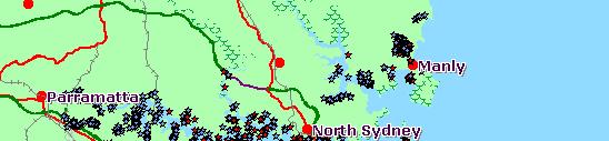
 Reducing the loss : Using high-resolution vulnerability assessments to enhance tsunami risk reduction strategies Using Manly, Sydney as a case study, Dall Osso and Dominey-Howes explore the implications
Development of the Kingdom of Tonga Cyclone Emergency Recovery and Management System using Geospatial Tools
 Development of the Kingdom of Tonga Cyclone Emergency Recovery and Management System using Geospatial Tools Case Studies from Small Island States FIG Commissions 3, 7 and 8 Malcolm Archbold General Manager
STUDY ON TSUNAMIGENIC EARTHQUAKE CRITERIA FOR THE INDONESIAN TSUNAMI EARLY WARNING SYSTEM
 STUDY ON TSUNAMIGENIC EARTHQUAKE CRITERIA FOR THE INDONESIAN TSUNAMI EARLY WARNING SYSTEM Nanang T. Puspito 1 1 Geophysics Research Group, Faculty of Mining and Petroleum Engineering, Institute of Technology
Numerical simulations for Investigation of the Coastline Erosion due to the 2004 Indian Ocean Tsunami
 Numerical simulations for Investigation of the Coastline Erosion due to the 2004 Indian Ocean Tsunami Syamsidik, Musa Al ala, Mirza Fahmi, and Tursina Tsunami Computation and Visualization Laboratory Tsunami
Papua New Guinea LiDAR Factsheet. Pacific-Australia Climate Change Science and Adaptation Planning. Vanimo. Bismark Sea. Wewak
 Pacific-Australia Climate Change Science and Adaptation Planning INDONESIA Vanimo Ninigo Group Wewak Madang Mount Hagen Kundiawa Goroka Mendi Daru AUSTRALIA Kerema Gulf of Papua Admiralty Islands Mussau
The Challenge of Earthquake Disaster in Indonesia. Hery Harjono Indonesian Institute of Sciences
 The Challenge of Earthquake Disaster in Indonesia Hery Harjono Indonesian Institute of Sciences * Presented at the J-Rapid Symposium, Sendai, Japan, March 6-7, 2013 INTRODUCTION The 2004 Giant Sumatran-Andaman
Seismic Activity and Crustal Deformation after the 2011 Off the Pacific Coast of Tohoku Earthquake
 J-RAPID Symposium March 6-7, 2013 Seismic Activity and Crustal Deformation after the 2011 Off the Pacific Coast of Tohoku Earthquake Y. Honkura Tokyo Institute of Technology Japan Science and Technology
STUDENT NAME: STUDENT NUMBER: Faculty of Science FINAL EXAMINATION ATMOSPHERIC & OCEANIC SCIENCES ATOC 185 EARTH & PLANETARY SCIENCES EPSC 185
 STUDENT NAME: STUDENT NUMBER: Faculty of Science FINAL EXAMINATION ATMOSPHERIC & OCEANIC SCIENCES ATOC 185 EARTH & PLANETARY SCIENCES EPSC 185 NATURAL DISASTERS Examiners: Professor J. Gyakum and Professor
The AIR Bushfire Model for Australia
 The AIR Bushfire Model for Australia In February 2009, amid tripledigit temperatures and drought conditions, fires broke out just north of Melbourne, Australia. Propelled by high winds, as many as 400
Tectonic Processes and Hazards Enquiry Question 1: Why are some locations more at risk from tectonic hazards?
 Tectonic Processes and Hazards Enquiry Question 1: Why are some locations more at risk from tectonic hazards? Key words Basalt Andesite Rhyolite Benioff Zone Subduction zone Crustal fracturing Definition
Advisors: Arcadii Grinshpan, Mathematics and Statistics Rocco Malservisi, School of Geosciences. Problem Suggested By: Rocco Malservisi
 Undergraduate Journal of Mathematical Modeling: One + Two Volume 8 2018 Spring 2018 Issue 2 Article 6 Tsunami Waves Samantha Pennino University of South Florida Advisors: Arcadii Grinshpan, Mathematics
What causes a tsunami?
 Listen: Have this page read to you [1] Have this page read to you [2] A tsunami is a series of waves in the sea caused by a movement on the sea floor. New Zealand is at risk from tsunami because it has
Lessons Learned from Past Tsunamis Warning and Emergency Response
 UNESCO IOC CTIC US NOAA ITIC Regional Training Workshop on Strengthening Tsunami Warning and Emergency Response Standard Operating Procedures and the Development of the ICG/CARIBE-EWS PTWC New Enhanced
ELEVATION IS FOUNDATIONAL. A DEM that is inaccurate or of poor resolution will pass those characteristics onto other data layers
 ELEVATION IS FOUNDATIONAL A DEM that is inaccurate or of poor resolution will pass those characteristics onto other data layers THE DEM IS FOUNDATIONAL TO ALL GIS (Geospatial Information System) LAYERS
Preparation for Future Earthquake and Tsunami Hazards: Lessons Learned from the 2004 Sumatra-Andaman Earthquake and the Asian Tsunami
 First International Conference of Aceh and Indian Ocean Studies Organized by Asia Research Institute, National University of Singapore & Rehabilitation and Construction Executing Agency for Aceh and Nias
2010 PERTH STORM 2010 MELBOURNE STORM
 2011 TOHOKU EARTHQUAKE 2010 PAKISTAN FLOODS 2010 CHINA FLOODS 2011 CYCLONE YASI 2010/2011 QUEENSLAND FLOODS 2010 PERTH STORM 2011 VICTORIA FLOOD 2010 MELBOURNE STORM 2010 DARFIELD EARTHQUAKE 2011 LYTTELTON
Tsunami! Beyond the Book. FOCUS Book
 FOCUS Book Use the engineering design process to design a structure that will protect a coastal town from possible tsunami damage. Brainstorm design ideas for your structure with a group of classmates.
Global Map: A Tool for Disaster Mitigation for the Asia and Pacific Region
 Global Map: A Tool for Disaster Mitigation for the Asia and Pacific Region D. R. Fraser Taylor Chair, International Steering Committee for Global Mapping (ISCGM) fraser_taylor@carleton.ca www. 18 th United
On Tsunami Risk Assessment for the West Coast of Thailand
 On Tsunami Risk Assessment for the West Coast of Thailand Farrokh Nadim International Centre for Geohazards (ICG) / Norwegian Geotechnical Institute Thomas Glade University of Bonn Geohazards - Technical,
Application of a GIS for Earthquake Hazard Assessment and Risk Mitigation in Vietnam
 Application of a GIS for Earthquake Hazard Assessment and Risk Mitigation in Vietnam Nguyen Hong Phuong Earthquake Information and Tsunami Warning Centre, VAST OUTLINE Introduction Fault Source Model and
SIMULATION OF A WORST CASE TSUNAMI SCENARIO FROM THE MANILA TRENCH TO VIETNAM
 SIMULATION OF A WORST CASE TSUNAMI SCENARIO FROM THE MANILA TRENCH TO VIETNAM Nguyen Hong Phuong, Vu Ha Phuong, Pham The Truyen Earthquake Information and Tsunami Warning Centre, VAST OUTLINE Earthquake
EMERGENCY PLANNING IN NORTHERN ALGERIA BASED ON REMOTE SENSING DATA IN RESPECT TO TSUNAMI HAZARD PREPAREDNESS
 EMERGENCY PLANNING IN NORTHERN ALGERIA BASED ON REMOTE SENSING DATA IN RESPECT TO TSUNAMI HAZARD PREPAREDNESS Barbara Theilen-Willige Technical University of Berlin, Institute of Applied Geosciences Department
TROPICAL CYCLONES IN A WARMER WORLD
 TROPICAL CYCLONES IN A WARMER WORLD Dr Mark Saunders Benfield Hazard Research Centre Department of Space and Climate Physics University College London Workshop for Under 35s Reinsurance Group 14th October
Dynamic Earth A B1. Which type of plate boundary is located at the Jordan Fault? (1) divergent (3) convergent (2) subduction (4) transform
 divergent (3) convergent (2) subduction (4) transform") Dynamic Earth A B1 1. The edges of most lithospheric plates are characterized by (1) reversed magnetic orientation (2) unusually rapid radioactive decay (3) frequent volcanic activity (4) low P-wave and
Dynamic Earth A B1 1. The edges of most lithospheric plates are characterized by (1) reversed magnetic orientation (2) unusually rapid radioactive decay (3) frequent volcanic activity (4) low P-wave and
Probabilistic Tsunami Hazard Analysis. Hong Kie Thio AECOM, Los Angeles
 Probabilistic Tsunami Hazard Analysis Hong Kie Thio AECOM, Los Angeles May 18, 2015 Overview Introduction Types of hazard analysis Similarities and differences to seismic hazard Methodology Elements o
GIS as a tool in flood management
 GIS for the United Nations and the International Community Conference Panel: GIS and Capacity - How Territorial Planning Benefits from Geospatial Information 3-5 April 2012 Geneva, Switzerland GIS as a
Earthquake and Tsunami Modeling in Japan. Renee Lee Product Manager, RMS
 Earthquake and Tsunami Modeling in Japan Renee Lee Product Manager, RMS RMS JAPAN EARTHQUAKE MODEL HISTORY 2011 GREAT EAST JAPAN EARTHQUAKE M9.0 SCOPE OF JAPAN EARTHQUAKE MODEL UPDATE (2012) Event Rate
MODELLING CATASTROPHIC COASTAL FLOOD RISKS AROUND THE WORLD
 MODELLING CATASTROPHIC COASTAL FLOOD RISKS AROUND THE WORLD Nicola Howe Christopher Thomas Copyright 2016 Risk Management Solutions, Inc. All Rights Reserved. June 27, 2016 1 OUTLINE MOTIVATION What we
NUMERICAL SIMULATION OF TSUNAMI PROPAGATION AND INUNDATION ALONG THE RAKHINE COAST AREAS IN MYANMAR
 NUMERICAL SIMULATION OF TSUNAMI PROPAGATION AND INUNDATION ALONG THE RAKHINE COAST AREAS IN MYANMAR Su Hninn Htwe Supervisor: Bunichiro SHIBAZAKI MEE12619 Yushiro FUJII ABSTRACT This study aimed to assess
28 th March 2005 magnitude 8.7 earthquake Northern Sumatra, Indonesia
 29 th March 2005 GAPResponse 28 th March 2005 magnitude 8.7 earthquake Northern Sumatra, Indonesia Russell Blong T: +61 2 8209 4288 F: +61 2 9241 2441 E: russell.blong@benfieldgroup.com Ben Miliauskas
An analysis on the relationship between land subsidence and floods at the Kujukuri Plain in Chiba Prefecture, Japan
 doi:10.5194/piahs-372-163-2015 Author(s) 2015. CC Attribution 3.0 License. An analysis on the relationship between land subsidence and floods at the Kujukuri Plain in Chiba Prefecture, Japan Y. Ito 1,
1 MAR 110 Lecture #1 Introduction to Oceans Hazards SECTION I Volcano, Earthquake, and Tsunami Hazards
 1 MAR 110 Lecture #1 Introduction to Oceans Hazards SECTION I Volcano, Earthquake, and Tsunami Hazards Ocean Basin Rim Hazards - Earthquakes Earthquake-Induced Oil Storage Tank Conflagration Valdez, Alaska.(NG)
1. INTRODUCTION, AIMS AND SCOPE
 1. INTRODUCTION, AIMS AND SCOPE 1.1 INTRODUCTION This thesis is concerned with the study of slope instability on the Illawarra Escarpment slopes in the northern half of the Wollongong City Council (WCC)
DEVASTATING DAMAGE DUE TO THE 2004 INDIAN OCEAN TSUNAMI AND ITS LESSONS
 DEVASTATING DAMAGE DUE TO THE 2004 INDIAN OCEAN TSUNAMI AND ITS LESSONS Fumihiko Imamura 1 1 Professor, Tsunami Engineering, Disaster Control Research Center, Tohoku University, Japan Email: imamura@tsunami2.civil.tohoku.ac.jp
SEISMIC HAZARD ANALYSIS AND SEISMIC INPUT TO TSUNAMI MODELING FOR MICROZONATION OF MEURAXA DISTRICT CITY OF BANDA ACEH
 SEISMIC HAZARD ANALYSIS AND SEISMIC INPUT TO TSUNAMI MODELING FOR MICROZONATION OF MEURAXA DISTRICT CITY OF BANDA ACEH I W. Sengara 1, Hendarto 1, P. Sumiartha 1, H. Latief 1, S.B. Kusuma 1 and Munirwansjah
Modeling Great Britain s Flood Defenses. Flood Defense in Great Britain. By Dr. Yizhong Qu
 Modeling Great Britain s Flood Defenses AIRCurrents Editor s note: AIR launched its Inland Flood Model for Great Britain in December 2008. The hazard module captures the physical processes of rainfall-runoff
Meeting the New Queensland Coastal Plan Storm Surge Requirements for Redland City Council. Queensland Coastal Conference 2011
 Meeting the New Queensland Coastal Plan Storm Surge Requirements for Redland City Council Ancient Knowledge Contemporary Innovation The Pullman Reef Hotel, Cairns Daniel Niven 1 and David Taylor 2 1 Cardno
GIS methodologies for local tsunami risk assessment: examples
 GIS methodologies for local tsunami risk assessment: examples R. Frauenfelder 1,2, C.B. Harbitz 1,2, Sverdrup-Thygeson 1,2, G. Kaiser 2,4, R. Swarny 3, L. Gruenburg 3, S. Glimsdal 1,2, F. Løvholt 1,2,
Determination of flood risks in the yeniçiftlik stream basin by using remote sensing and GIS techniques
 Determination of flood risks in the yeniçiftlik stream basin by using remote sensing and GIS techniques İrfan Akar University of Atatürk, Institute of Social Sciences, Erzurum, Turkey D. Maktav & C. Uysal
Section C: Management of the Built Environment GIS As A Tool: Technical Aspects of Basic GIS
 Section C: Management of the Built Environment GIS As A Tool: Technical Aspects of Basic GIS This lecture covers five topics: 1.Scale, 2.Framework data, 3.Generalisation, 4.Aggregation, 5.Modifiable unit
REPORT ON THE TOHOKU AREA PASIFIC OFFSHORE EARTHQUAKE
 REPORT ON THE TOHOKU AREA PASIFIC OFFSHORE EARTHQUAKE GENERAL PERSPECTIVE The Highest Magnitude Ever Recorded The 2011 off the Pacific Coast of Tohoku Earthquake (hereafter, the 2011 Tohoku- Pacific Earthquake
NW Pacific and Japan Landfalling Typhoons in 2000
 NW Pacific and Japan Landfalling Typhoons in 2000 Pre-Season Forecast Issued 26th May, 2000 Produced under contract for TSUNAMI in collaboration with the UK Met. Office by Drs Paul Rockett, Mark Saunders
APPLICATON OF SEAMLESS SIMULATION OF SEISMIC RESPONSE ANALYSIS AND HIGH RESOLUTION TSUNAMI SIMULATION TO COASTAL AREA OF SENDAI
 Proceedings of the International Symposium on Engineering Lessons Learned from the 2011 Great East Japan Earthquake, March 1-4, 2012, Tokyo, Japan APPLICATON OF SEAMLESS SIMULATION OF SEISMIC RESPONSE
Application of low-cost geo-informatics for disaster risk assessments with focus on coastal regions
 Centre of Applied Geoscience, Disaster Risk Reduction Group, School of Earth and Environmental Science, University of Portsmouth, UK Application of low-cost geo-informatics for disaster risk assessments
J M MIRANDA UNIVERSITY OF LISBON THE USE OF REMOTE SENSING FOR EARTHQUAKE RISK ASSESSMENT AND MITIGATION
 1 THE USE OF REMOTE SENSING FOR EARTHQUAKE RISK ASSESSMENT AND MITIGATION 2 the observation of strong ground motion and aftershock sequences as well as the investigation of the destruction from these earthquakes
New A-Level Physical Geography
 Half Term 1 3.1 Physical Geography: 3.1.5 Hazards: Plate Tectonics This optional section of our specification focuses on the lithosphere and the atmosphere, which intermittently but regularly present natural
Sea Level Rise and Coastal Inundation Thursday 11 th October, 2012, 1.00pm, With lunch in the Legislative Council Committee Room
 The Presiding Officers invite Parliamentarians and Staff to a Science Briefing on Sea Level Rise and Coastal Inundation Thursday 11 th October, 2012, 1.00pm, With lunch in the Legislative Council Committee
GIS and Remote Sensing Support for Evacuation Analysis
 GIS and Remote Sensing Support for Evacuation Analysis Presented to GIS for Transportation Symposium Rapid City, South Dakota March 28-31, 2004 Demin Xiong Oak Ridge National Laboratory 2360 Cherahala
What is a Tsunami? Tsu = harbor Nami = wave (Japanese terms)
") Tsunami Hazard What is a Tsunami? Tsu = harbor Nami = wave (Japanese terms) A tsunami is a series of travelling waves most commonly generated by vertical displacements of the sea floor associated with
Tsunami Hazard What is a Tsunami? Tsu = harbor Nami = wave (Japanese terms) A tsunami is a series of travelling waves most commonly generated by vertical displacements of the sea floor associated with
The Use of Spatial Analysis Techniques in Mapping Potential Natural Hazard Areas: A Case Study of Taiwan.
 Available online at www.sciencedirect.com Procedia Environmental Sciences 10 (2011 ) 1092 1097 2011 3rd International Conference on Environmental 2011 3rd International Science Conference and Information
Mapping of Future Coastal Hazards. for Southern California. January 7th, David Revell, Ph.D. E.
 Mapping of Future Coastal Hazards for Southern California January 7th, 2014 David Revell, Ph.D. drevell@esassoc.com E. Vandebroek, 2012 Outline Coastal erosion hazard zones Flood hazard zones: Coastal
Remote Sensing and GIS Contribution to. Tsunami Risk Sites Detection. of Coastal Areas in the Mediterranean
 The Third International Conference on Early Warning (EWC III), 26.-29.March 2006 in Bonn Remote Sensing and GIS Contribution to Tsunami Risk Sites Detection of Coastal Areas in the Mediterranean BARBARA
Application #: TEXT
 TOWN OF FORT MYERS BEACH 2008 PROPOSED COMPREHENSIVE PLAN AMENDMENTS Application #: 2008-13-TEXT Description: Modify the Coastal Management and Future Land Use Elements to reflect the state s new definition
Earth Issue: November 2017
 Earth Issue: November 2017 Earthquake Risk In Indonesia Damage in Banda Aceh During 2004 tsunami Source: US Military The Indonesian archipelago is located at the boundary of three major tectonic plates,
NGIAs' roles in successful disaster response
 The Second UN-GGIM-AP Plenary Meeting NGIAs' roles in successful disaster response Japan Teheran Iran 28 October 2013 Shin-ichi SAKABE, Director of International Affairs Division Geospatial Information
NORTH VISTA SECONDARY SCHOOL HUMANITIES DEPARTMENT SECONDARY 3 EXPRESS HUMANITIES (GEOGRAPHY) 2272/02 CONTENT OUTLINE Term 1
 2272/02 CONTENT OUTLINE Term 1") NORTH VISTA SECONDARY SCHOOL HUMANITIES DEPARTMENT SECONDARY 3 EXPRESS HUMANITIES (GEOGRAPHY) 2272/02 CONTENT OUTLINE 2019 Term 1 Week Learning Outcomes Skills to be covered Assignment Test Project 1-2
NORTH VISTA SECONDARY SCHOOL HUMANITIES DEPARTMENT SECONDARY 3 EXPRESS HUMANITIES (GEOGRAPHY) 2272/02 CONTENT OUTLINE 2019 Term 1 Week Learning Outcomes Skills to be covered Assignment Test Project 1-2
Storms. 3. Storm types 4. Coastal Sectors 5. Sorm Location and Seasonality 6. Storm Severity 7. Storm Frequency and grouping 8. The design storm event
 1. Introduction Storms 2. The Impact of Storms on the coast 3. Storm types 4. Coastal Sectors 5. Sorm Location and Seasonality 6. Storm Severity 7. Storm Frequency and grouping 8. The design storm event
CAT-i Bulletin Catastrophe Information
 CAT-i Bulletin Catastrophe Information Report Date: December 28, 2018 Sydney Hailstorms, December 20, 2018 Hail Swath for the Sydney Hail Event. Source: Dr Joshua Soderholm, Monash University, using radar