Numerical simulations for Investigation of the Coastline Erosion due to the 2004 Indian Ocean Tsunami
|
|
|
- Tabitha Davis
- 5 years ago
- Views:
Transcription
, Syiah Kuala University,")
1 Numerical simulations for Investigation of the Coastline Erosion due to the 2004 Indian Ocean Tsunami Syamsidik, Musa Al ala, Mirza Fahmi, and Tursina Tsunami Computation and Visualization Laboratory Tsunami and Disaster Mitigation Research Center (TDMRC), Syiah Kuala University, Indonesia
2 Introduction After more than one decade of the 2004 Indian Ocean tsunami, the tsunami affected coastal areas have another state of of its natural balance, shaping a new coastal line. Some of the areas bounced back to re-create a coastal line almost similar to the condition before the 2004 tsunami. However, some of the affected coast could not being recovered until the present due to some factors. The tsunami affected regions in Aceh of Indonesia are mostly located around the South-Western Coast of the Sumatra Island. This area was told to have a number of tsunamis since 1,000 years ago (Monecke et al., 2008). This reflects the vulnerability of the region towards the tsunami. Considering the state of the area towards the tsunami, it would be necessary to understand the process of the coastal recovery around this area that can be used for further coastal zone management. The objective of this paper is to investigate the impacts of the tsunami waves on the area by means of numerical simulations and to monitor the land use changes around the coastal area that were driven by the coastal morphological recovery process. Unlike other areas around the Indian Ocean, less attention has been put to observe the detail coastal process contributing to the impacts of the tsunami waves and the coastal recovery process. Other studies could be found around Tohoku region of Japan after the 2011 Great East Japan Earthwquake and Tsunami/GEJET (Tanaka et al., 2014).


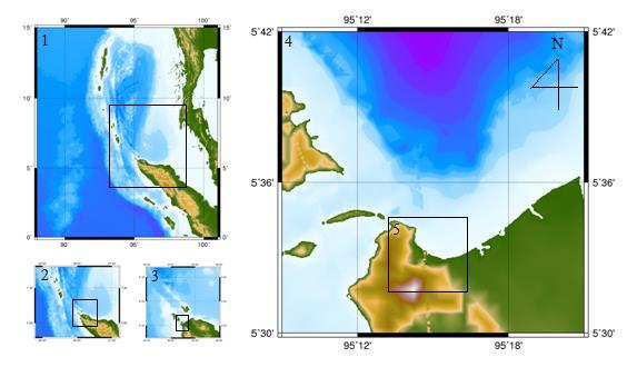
3 Study Area: Teluk Ulee Lheue Before the 2004 tsunami After the tsunami


4 Data Preparation 1. Bathymetri Data GEBCO- Layer 1-3 DISHIDROS TNI AL Layer 4-5 Public Works Dept 2006 layer 5 2. Topography Data Acepmap.com Public Works Indonesia Simulation Domain: Ulee Lheue Bay
5 Simulations Tsunami Wave Propagation Simulations: Initial Waves used Romano (2009) based on mulfi fault scenarios for the 2004 Tsunami; Layer 1-4 were simulated using Cornell Multi-Grid Coupled Tsunami Model (COMCOT); Layer 5 (the innermost layer) was simulated using DELFT3-D Flow, where the boundary condition was adopted from results of tsunami waves propagation produced by COMCOT.
6
 Ponds (0.017) Paddy Field (0.022) Forest (0.")
 Sediment Characteristics Mountain Coastline")
7 Manning Coefficients Ocean (0.013) Beach (0.020) Ponds (0.017) Paddy Field (0.022) Forest (0.035) Housing (0.040) Sediment Characteristics Mountain Coastline before tsunami Very Fine Sand Fine Sand Medium Fine Sand Coral


8 Results Validation Validation of tsunami wave heights from Jason1 Initial Waves

9 Tsunami wave heights around the near shore area

10 Tsunami Waves Propagation around the Study Site


11 Initial Waves Proses penjalaran tsunami dengan model COMCOT Layer 1 Layer 4

12 Tsunami Inundation Area


13 Proses penjalaran tsunami dengan model Delft3D Water Depth Cumulative erosion and sedimentation

14 Coastal Line Changes Sea Land Coastline before tsunami Simulated Coastline Coastline after tsunami

")

15 Time after tsunami (sec) Time after tsunami (Local Time)
16 Distance at Cross Shore Coastal Profile Changes Cross 1 Cross 1 Distance at Cross Shore Cross 2 Cross 2
17 Perubahan profil pantai Cross 3 Perubahan profil pantai pada Cross 3 Perubahan profil pantai pada Cross 4 Cross 4

18 Erosion and Deposit of sediment due to tsuanmi waves Hillside Initial coastline
19 Recovery of the Coastal Area after 12- Year of the tsunami

20 Year 2003

21 Year 2005
22 Tahun 2010

23 Year 2011
24 Year 2015

25 Mangrove Area Housing Area
26 Area (m²) Cummulative Area of Housing Complex in the Study Area Shifting closer to the coastline Distance from shore line (m)
27 Conclusions Numerical simulations and spatial analysis were performed in this research to observe the impacts of the 2004 Indian Ocean tsunami and also the coastal area recovery process during one decade after the tsunami. The tsunami inundation area based on the numerical simulations has been confirmed to actual data of the tsunami inundation limit. Although the erosion process due to the tsunami waves has been fairly agreeable to the actual data, the simulation has successfully proven the severe erosion process at some points in the study area. The coastal recovery process around this study area shows a return of new coastal line after one-decade of the 2004 tsunami. Furthermore, the coastal settlement has been seen to take place at the same location where it was before the tsunami. Land use types in the coastal area seem to follow the land use pattern before the tsunami. Despite this, some paddy field areas could not be recovered due to high salinity intrusion around the area.
28 Thank you
Interactive comment on Assessing the tsunami mitigation effectiveness of a planned Banda Aceh Outer Ring Road (BORR), Indonesia by Syamsidik et al.
, Indonesia by Syamsidik et al.") Nat. Hazards Earth Syst. Sci. Discuss., https://doi.org/10.5194/nhess-2018-276-ac2, 2018 Author(s) 2018. This work is distributed under the Creative Commons Attribution 4.0 License. Interactive comment
Nat. Hazards Earth Syst. Sci. Discuss., https://doi.org/10.5194/nhess-2018-276-ac2, 2018 Author(s) 2018. This work is distributed under the Creative Commons Attribution 4.0 License. Interactive comment
Developing fragility functions for tsunami damage estimation using the numerical model and satellite imagery
 Developing fragility functions for tsunami damage estimation using the numerical model and satellite imagery Shunichi KOSHIMURA 1 and Hideaki YANAGISAWA 2 1 Associate Professor, Disaster Control Research
DATA BASE DEVELOPMENT OF ETA (ESTIMATED TIME OF ARRIVAL) FOR TSUNAMI DISASTER MITIGATION AT SOUTHWESTERN CITIES OF ACEH, INDONESIA
 FOR TSUNAMI DISASTER MITIGATION AT SOUTHWESTERN CITIES OF ACEH, INDONESIA") 6 th South China Sea Tsunami Workshop Nanyang Technology University, Singapore, 6-8 November 2013 DATA BASE DEVELOPMENT OF ETA (ESTIMATED TIME OF ARRIVAL) FOR TSUNAMI DISASTER MITIGATION AT SOUTHWESTERN
6 th South China Sea Tsunami Workshop Nanyang Technology University, Singapore, 6-8 November 2013 DATA BASE DEVELOPMENT OF ETA (ESTIMATED TIME OF ARRIVAL) FOR TSUNAMI DISASTER MITIGATION AT SOUTHWESTERN
NUMERICAL SIMULATION OF TSUNAMI PROPAGATION AND INUNDATION ALONG THE RAKHINE COAST AREAS IN MYANMAR
 NUMERICAL SIMULATION OF TSUNAMI PROPAGATION AND INUNDATION ALONG THE RAKHINE COAST AREAS IN MYANMAR Su Hninn Htwe Supervisor: Bunichiro SHIBAZAKI MEE12619 Yushiro FUJII ABSTRACT This study aimed to assess
VALIDATION OF TSUNAMI INUNDATION MODELING FOR THE 2004 SUMATRA-ANDAMAN EARTHQUAKE FOR MAKING HAZARD MAPS IN PENANG AND LANGKAWI, MALAYSIA
 Synopses of Master Papers Bulletin of IISEE, 47, 11-16, 013 VALIDATION OF TSUNAMI INUNDATION MODELING FOR THE 004 SUMATRA-ANDAMAN EARTHQUAKE FOR MAKING HAZARD MAPS IN PENANG AND LANGKAWI, MALAYSIA Noor
NUMERICAL SIMULATION AS GUIDANCE IN MAKING TSUNAMI HAZARD MAP FOR LABUAN ISLAND
 NUMERICAL SIMULATION AS GUIDANCE IN MAKING TSUNAMI HAZARD MAP FOR LABUAN ISLAND MOHD RIDZUAN bin Adam Supervisor: Fumihiko IMAMURA MEE09199 ABSTRACT At the northeast end of the South China Sea, tsunamis
Strategic approach towards Post Tsunami Mitigation and Conservation of the Sri Lankan coastline
 Strategic approach towards Post Tsunami Mitigation and Conservation of the Sri Lankan coastline Dr. S.S.L.Hettiarachchi Dr. S.P.Samarawickrama University of Moratuwa Illustrated via a Case Study for the
Developed in Consultation with Florida Educators
 Developed in Consultation with Florida Educators Table of Contents Next Generation Sunshine State Standards Correlation Chart... 7 Benchmarks Chapter 1 The Practice of Science...................... 11
Wainui Beach Management Strategy (WBMS) Summary of Existing Documents. GNS Tsunami Reports
 Summary of Existing Documents. GNS Tsunami Reports") Wainui Beach Management Strategy (WBMS) Summary of Existing Documents GNS Tsunami Reports a) Review of Tsunami Hazard and Risk in New Zealand ( National Risk Report ) b) Review of New Zealand s Preparedness
Wainui Beach Management Strategy (WBMS) Summary of Existing Documents GNS Tsunami Reports a) Review of Tsunami Hazard and Risk in New Zealand ( National Risk Report ) b) Review of New Zealand s Preparedness
Integrated Approach to Assess the Impact of Tsunami Disaster
 Integrated Approach to Assess the Impact of Tsunami Disaster Shunichi Koshimura & Shintaro Kayaba Disaster Control Research Center, Graduate School of Engineering, Tohoku University, Japan Masashi Matsuoka
Building Disaster Resilience Community in Asia: Indonesian perspective
 Workshop C of the 7th Science Council of Asia (SCA) Conference Construction of Secure and Safe Society against Global Changes of Natural Disasters Okinawa, June 14 th, 2007 Building Disaster Resilience
Predicting of Tsunami Inundation Area based on Propagation and Runup Numerical Model in Pacitan City
 Predicting of Tsunami Inundation Area based on Propagation and Runup Numerical Model in Pacitan City 1 Agus Suharyanto, 1 Alwafi Pujiraharjo, 2 Adipandang Yudono, 3 Keisuke Murakami, and 3 Chikashi Deguchi
Predicting tsunami waves and currents on the West Coast of Canada: A case study for Ucluelet, BC
 Predicting tsunami waves and currents on the West Coast of Canada: A case study for Ucluelet, BC Josef Cherniawsky, Kelin Wang and Roy Walters Institute of Ocean Sciences, Fisheries & Oceans Canada Pacific
Riskscape module Documentation: Inundation Modelling in Bay of Plenty. X. Wang C. Mueller
 Riskscape module Documentation: Inundation Modelling in Bay of Plenty X. Wang C. Mueller CONTENTS 1.0 GENERAL INFORMATION... 2 1.1 SITE OF STUDY... 5 1.2 SOURCE SCENARIOS... 5 1.3 NUMERICAL MODEL... 5
Abdul Muhari 1, Fumihiko Imamura 2, Taro Arikawa 3, and Bagus Afriyanto 1. Date; 15 October 2018
 Finding of the unexpected tsunami due to the strike-slip fault at central Sulawesi, Indonesia on 28 September 2018, from the preliminary field survey at Palu Abdul Muhari 1, Fumihiko Imamura 2, Taro Arikawa
FIG Working Week May, Bulgaria From the wisdom of the ages to the challanges of modern world
 FIG Working Week 17-21 May, Bulgaria From the wisdom of the ages to the challanges of modern world COASTAL RISK ANALYSIS OF THE BLACK SEA UNDER THE SEA LEVEL RISE N e v i n B e t u l A V S A R, S e n o
Impact of Changes in Morphology on Extent and Duration of Inundation during Tropical Cyclones
 DISTRIBUTION STATEMENT A. Approved for public release; distribution is unlimited. Impact of Changes in Morphology on Extent and Duration of Inundation during Tropical Cyclones Jayaram Veeramony Code 7322,
DEVASTATING DAMAGE DUE TO THE 2004 INDIAN OCEAN TSUNAMI AND ITS LESSONS
 DEVASTATING DAMAGE DUE TO THE 2004 INDIAN OCEAN TSUNAMI AND ITS LESSONS Fumihiko Imamura 1 1 Professor, Tsunami Engineering, Disaster Control Research Center, Tohoku University, Japan Email: imamura@tsunami2.civil.tohoku.ac.jp
JNES open code for Tsunami Hazard Assessments at NPP site supplied in IAEA/Tsunami EBP
 ANSN Regional Workshop on Site Selection and Evaluation for Nuclear Power Plants June 2010, Hanoi Vietnam IAEA/ISSC JNES open code for Tsunami Hazard Assessments at NPP site supplied in IAEA/Tsunami EBP
GLY Coastal Geomorphology Notes
 GLY 4734 - Coastal Geomorphology Notes Dr. Peter N. Adams Spring 2011 2 Coastal Classification In this lecture, we discuss some successful classification schemes of the coastal landscape, and pay particular
ANALYSIS OF BATHYMETRY CHANGE AROUND GROYNE SYSTEM ON ISHINOMAKI COAST
 東北地域災害科学研究第 巻 (1) 15 ANALYSIS OF BATHYMETRY CHANGE AROUND GROYNE SYSTEM ON ISHINOMAKI COAST Tohoku University, Widyaningtias 1, Hitoshi Tanaka ABSTRACT Coastal protection has been an interesting case to
2. Tsunami Source Details
 2. Tsunami Source Details The Northland area faces a range of potential tsunamigenic sources that include several local and distant fault systems and underwater landslides. A NIWA study (Goff et al. 2006)
(energy loss is greater with longer wavelengths)
") GEOL 0820 Ramsey Natural Disasters Spring, 2018 LECTURE #9: Tsunami Monitoring & Mitigation Date: 8 February 2018 I. Characteristics (con t): shoaling: o process of wave height increase and breaking as
GEOL 0820 Ramsey Natural Disasters Spring, 2018 LECTURE #9: Tsunami Monitoring & Mitigation Date: 8 February 2018 I. Characteristics (con t): shoaling: o process of wave height increase and breaking as
We have previously looked at artificial seismograms such as this one here.
 We have previously looked at artificial seismograms such as this one here. S P A realistic Seismic Record Each vertical line = 1 minute Each horizontal line = 15 minutes Seismic station PMM is in Parkfield,
Indian Ocean Tsunami Warning System: Example from the 12 th September 2007 Tsunami
 Indian Ocean Tsunami Warning System: Example from the 12 th September 2007 Tsunami Charitha Pattiaratchi 1 Professor of Coastal Oceanography, The University of Western Australia Email: chari.pattiaratchi@uwa.edu.au
Unit 1: Water Systems on Earth Chapter 2
 Unit 1: Water Systems on Earth Chapter 2 Create a mind map with the driving question, Why are Oceans Important? Remember: Why are oceans so important? Why are oceans so important? Primary water source
Earthquake Hazards. Tsunami
 Earthquake Hazards Tsunami Measuring Earthquakes Two measurements that describe the power or strength of an earthquake are: Intensity a measure of the degree of earthquake shaking at a given locale based
Earthquake Hazards. Tsunami
 Earthquake Hazards Tsunami Review: What is an earthquake? Earthquake is the vibration (shaking) and/or displacement of the ground produced by the sudden release of energy. The point inside the Earth where
Semi-enclosed seas. Estuaries are only a particular type of semi-enclosed seas which are influenced by tides and rivers
 Semi-enclosed seas Estuaries are only a particular type of semi-enclosed seas which are influenced by tides and rivers Other semi-enclosed seas vary from each other, mostly by topography: Separated from
NUMERICAL SIMULATIONS FOR TSUNAMI FORECASTING AT PADANG CITY USING OFFSHORE TSUNAMI SENSORS
 NUMERICAL SIMULATIONS FOR TSUNAMI FORECASTING AT PADANG CITY USING OFFSHORE TSUNAMI SENSORS Setyoajie Prayoedhie Supervisor: Yushiro FUJII MEE10518 Bunichiro SHIBAZAKI ABSTRACT We conducted numerical simulations
Overview of Consequences of the Tsunami in Thailand and Roles and Activities of the Department of Mineral Resources after the 26 December 2004 Tsunami
 Overview of Consequences of the Tsunami in Thailand and Roles and Activities of the after the 26 December 2004 Tsunami By Mr.Worawoot Tantiwanit, Thailand 1 Earthquake in NW of North Sumatra Island 580
Updating the GEBCO Grid
 Updating the GEBCO Grid PAULINE WEATHERALL, GEBCO DIGITAL ATLAS MANAGER, BRITISH OCEANOGRAPHIC DATA CENTRE (BODC), NATIONAL OCEANOGRAPHY CENTRE (NOC), LIVERPOOL, UK. GEBCO TSCOM and SCRUM meeting, Kuala
GIS & Natural Hazards
 GIS & Natural Hazards John McAneney Risk Frontiers 1 mm 10 mm 100 mm 1000 mm 0 1 2 10000 mm kilometres Risk Frontiers An independent and local research capability to: help insurers and reinsurers better
News Release December 30, 2004 The Science behind the Aceh Earthquake
 News Release December 30, 2004 The Science behind the Aceh Earthquake PASADENA, Calif. - Kerry Sieh, the Robert P. Sharp Professor of Geology at the California Institute of Technology and a member of Caltech's
Australian Coastal Councils Conference
 Australian Coastal Councils Conference 11 March 2015 Estimating Future Coastal Inundation and Erosion Hazards Dr Andrew McCowan Dr Christine Lauchlan-Arrowsmith Warwick Bishop Background Victorian Future
SIMULATION OF FUTURE ANDAMAN TSUNAMI INTO STRAITS OF MALACCA BY TUNA
 Journal of Earthquake and Tsunami, Vol. 3, No. 2 (29) 89 1 c World Scientific Publishing Company SIMULATION OF FUTURE ANDAMAN TSUNAMI INTO STRAITS OF MALACCA BY TUNA KOH HOCK LYE,, TEH SU YEAN,KEWLEEMING
VULNERABILITY FUNCTIONS FOR BUILDINGS BASED ON DAMAGE SURVEY DATA IN SRI LANKA AFTER THE 2004 INDIAN OCEAN TSUNAMI. Murao, O. 1, Nakazato, H.
 371 VULNERABILITY FUNCTIONS FOR BUILDINGS BASED ON DAMAGE SURVEY DATA IN SRI LANKA AFTER THE 2004 INDIAN OCEAN TSUNAMI Murao, O. 1, Nakazato, H. 2 1 Graduate School of Systems and Information Engineering,
Assessing Building Vulnerability to Tsunami Hazard in Padang. Keywords: Building vulnerability; tsunami hazard; risk analysis
 Jurnal Teknologi Full paper Assessing Building Vulnerability to Tsunami Hazard in Padang Leli Honesti a*, Muhd Zaimi Abd Majid a, Meli Muchlian b, Nazwar Djali c a Department of Structure and Material,
RING 2 RING 2. Banda Aceh. Quick Bird Natural Color Image 28 December Grand Mosque. 3.3km. Destroyed Shoreline/Town. Flooded. Areas.
 Learning from Nanggroe Aceh Darussalam Some Notes on Post-Tsunami Rehabilitation in Calang, Aceh Jaya Dr. Widjaja Martokusumo School of Architecture, Planning and Policy Development Institut Teknologi
THE DEPOSITS OF TSUNAMIS WESLEY PESANTEZ, CATHERINE NIELD, COLIN WINTER
 THE DEPOSITS OF TSUNAMIS WESLEY PESANTEZ, CATHERINE NIELD, COLIN WINTER AN OVERVIEW OF OUR SEMINAR WHAT IS A TSUNAMI WHY STUDY TSUNAMIS PROPERTIES OF TSUNAMIS TSUNAMI HYDRODYNAMICS IDEALIZED DEPOSITS SEDIMENT
REDUCTION OF TSUNAMI INUNDATION ENERGY BY THE MODIFICATION OF COASTAL TOPOGRAPHY BASED ON LOCAL WISDOM
 Proceedings of the 7 th International Conference on Asian and Pacific Coasts (APAC 2013) Bali, Indonesia, September 24-26, 2013 REDUCTION OF TSUNAMI INUNDATION ENERGY BY THE MODIFICATION OF COASTAL TOPOGRAPHY
Tsunami. Harry Yeh Oregon State University. Eastern Japan Earthquake Disaster Briefing at PEER: April 28, 2011
 Tsunami by Harry Yeh Oregon State University Eastern Japan Earthquake Disaster Briefing at PEER: April 28, 2011 Seismic Characteristics Rupture Model (Harvard Seismology) The fault rupture process was
How to communicate Cascadia Subduction Zone earthquake hazards
 How to communicate Cascadia Subduction Zone earthquake hazards Tom Brocher Research Geophysicist Earthquake Science Center U.S. Geological Survey Menlo Park, California Seattle Post-Intelligencer Lessons
TSUNAMI HAZARD ASSESSMENT IN NORTHERN EGYPT USING NUMERICAL SIMULATION
 TSUNAMI HAZARD ASSESSMENT IN NORTHERN EGYPT USING NUMERICAL SIMULATION Abutaleb Ali Supervisor: Bunichiro SHIBAZAKI MEE16717 Yushiro FUJII ABSTRACT To investigate the tsunami hazard along the northern
Inversion of tsunami data. A. Sladen CNRS, Géoazur 1/35
 Inversion of tsunami data A. Sladen CNRS, Géoazur 1/35 DEFINITION Tsunami waves are gravity wave with a long period need a BIG source! 2/35 DEFINITION Krakatoa, 1883 Summer 2015, E.T. pers. comm. Lituya
Coastal Vulnerability Assessment in Semarang City, Indonesia Based on Sea Level Rise and Land Subsidence Scenarios
 Coastal Vulnerability Assessment in Semarang City, Indonesia Based on Sea Level Rise and Land Subsidence Scenarios I. M. Radjawane, D. Hartadi and W. R. Lusano Oceanography Research Division Fac. of Earth
The Coast: Beaches and Shoreline Processes
 1 2 3 4 5 6 7 8 9 The Coast: es and Shoreline Processes Trujillo & Thurman, Chapter 10 Oceanography 101 Chapter Objectives Recognize the various landforms characteristic of beaches and coastal regions.
INFLUENCE OF TSUNAMI INDUCED SCOURING ACTION ON FOUNDATION STABILITY OF COASTAL STRUCTURES
 International Journal of Civil Engineering and Technology (IJCIET) Volume 9, Issue 7, July 2018, pp. 889 894, Article ID: IJCIET_09_07_093 Available online at http://www.iaeme.com/ijciet/issues.asp?jtype=ijciet&vtype=9&itype=7
The Coast: Beaches and Shoreline Processes Trujillo & Thurman, Chapter 10
 The Coast: es and Shoreline Processes Trujillo & Thurman, Chapter 10 Oceanography 101 Chapter Objectives Recognize the various landforms characteristic of beaches and coastal regions. Identify seasonal
EXTERNAL LAND FORMING PROCESSES
 NAME SCHOOL INDEX NUMBER DATE EXTERNAL LAND FORMING PROCESSES WEATHERING 1 1998 Q 7 (a) (i) What is the difference between weathering and mass wasting (ii) List five processes involved in chemical weathering
Process-based Long Term Morphological Modelling the present state-of-the-art and the way ahead. Dirk-Jan Walstra
 Process-based Long Term Morphological Modelling the present state-of-the-art and the way ahead Dirk-Jan Walstra Deltares Delft Hydraulics Delft University of Technology Les littoraux à l heure du changement
Coupling of Wave and Hydrodynamic Models for Predicting Coastal Inundation: A case study in Jakarta and Semarang
 Coupling of Wave and Hydrodynamic Models for Predicting Coastal Inundation: A case study in Jakarta and Semarang http://peta-maritim.bmkg.go.id/cifdp/maps Nelly Florida Riama,Andri Ramdhani, Andi Eka Sakya,,
TSUNAMI PROPAGATION AND INUNDATION MODELINGS ALONG SOUTH-EAST COAST OF PAPUA NEW GUINEA
 TSUNAMI PROPAGATION AND INUNDATION MODELINGS ALONG SOUTH-EAST COAST OF PAPUA NEW GUINEA Martin WAREK Supervisor: Yushiro FUJII MEE12620 Bunichiro SHIBAZAKI ABSTRACT This study covers tsunami generation,
Numerical Modeling for the Propagation of Tsunami Wave and Corresponding Inundation
 IOSR Journal of Mechanical and Civil Engineering (IOSR-JMCE) e-issn: 78-1684,p-ISSN: 30-334X, Volume 1, Issue Ver. IV (Mar - Apr. 015), PP 55-6 www.iosrjournals.org Numerical Modeling for the Propagation
Monitoring Coastal Change after the Tsunami in Thailand
 IOP Conference Series: Earth and Environmental Science OPEN ACCESS Monitoring Coastal Change after the Tsunami in Thailand To cite this article: W Pantanahiran 2014 IOP Conf. Ser.: Earth Environ. Sci.
Mapping Coastal Change Using LiDAR and Multispectral Imagery
 Mapping Coastal Change Using LiDAR and Multispectral Imagery Contributor: Patrick Collins, Technical Solutions Engineer Presented by TABLE OF CONTENTS Introduction... 1 Coastal Change... 1 Mapping Coastal
Lessons from the 2004 Sumatra earthquake and the Asian tsunami
 Lessons from the 2004 Sumatra earthquake and the Asian tsunami Kenji Satake National Institute of Advanced Industrial Science and Technology Outline 1. The largest earthquake in the last 40 years 2. Tsunami
Holocene evolution of Dahab coastline Gulf of Aqaba, Sinai Peninsula, Egypt 1
 Holocene evolution of Dahab coastline Gulf of Aqaba, Sinai Peninsula, Egypt 1 Magdy Torab* 2 * Prof. of Geomorphology, Department of Geography, Damanhour University, Egypt 3 E-mail: magdytorab@hotmail.com.
BIBLIOGRAPHIC REFERENCE
 BIBLIOGRAPHIC REFERENCE Power, W. L.; Wang, X.; Barberopoulou, A.; Mueller, C. 2014. Validation of a deaggregation-based approach for tsunami evacuation mapping, GNS Science Report 2014/36. 56 p. W. L.
Changes in Ecosystems - Natural Events
 Changes in Ecosystems - Natural Events 8A predict and describe how different types of catastrophic events impact ecosystems such as floods, hurricanes, or tornadoes Textbook pages: 396-406 How can ecosystems
Summary Visualizations for Coastal Spatial Temporal Dynamics
 Summary Visualizations for Coastal Spatial Temporal Dynamics October 24 2011 Providence, RI Sidharth Thakur 1, Laura Tateosian 2, Helena Mitasova, Eric Hardin, and Margery Overton 1. sthakur@renci.org,
Section 2.1 Ocean Basins. - Has helped determine where ocean basins are located. - Tectonic plates move changing the position of the continents.
 Science 8 Unit 1: Water Systems on Earth Chapter 2: Oceans Control the Water Cycle Section 2.1 Ocean Basins Oceans are important because: 1. Primary water source for the water cycle 2. Control weather
SIMULATION OF A WORST CASE TSUNAMI SCENARIO FROM THE MANILA TRENCH TO VIETNAM
 SIMULATION OF A WORST CASE TSUNAMI SCENARIO FROM THE MANILA TRENCH TO VIETNAM Nguyen Hong Phuong, Vu Ha Phuong, Pham The Truyen Earthquake Information and Tsunami Warning Centre, VAST OUTLINE Earthquake
AN ANALYSIS OF TSUNAMI INUNDATION IN MANDALIKA TOURISM AREA (STAGE I) CENTRAL LOMBOK, WEST NUSA TENGGARA
 CENTRAL LOMBOK, WEST NUSA TENGGARA") International Journal of Civil Engineering and Technology (IJCIET) Volume 9, Issue 7, July 2018, pp. 87 95, Article ID: IJCIET_09_07_008 Available online at http://www.iaeme.com/ijciet/issues.asp?jtype=ijciet&vtype=9&itype=7
International Journal of Civil Engineering and Technology (IJCIET) Volume 9, Issue 7, July 2018, pp. 87 95, Article ID: IJCIET_09_07_008 Available online at http://www.iaeme.com/ijciet/issues.asp?jtype=ijciet&vtype=9&itype=7
Introduction to Environmental Geology, 5e Case History: Indonesian Tsunami Indonesian Tsunami (2) Introduction Historic Tsunamis
 Introduction Historic Tsunamis") 1 2 3 4 5 6 7 8 9 Introduction to Environmental Geology, 5e Chapter 7 Tsunami Case History: Indonesian Tsunami December 26, 2004, within a few hours, close to 250,000 people were killed With no warning
1 2 3 4 5 6 7 8 9 Introduction to Environmental Geology, 5e Chapter 7 Tsunami Case History: Indonesian Tsunami December 26, 2004, within a few hours, close to 250,000 people were killed With no warning
Tsunami! Beyond the Book. FOCUS Book
 FOCUS Book Use the engineering design process to design a structure that will protect a coastal town from possible tsunami damage. Brainstorm design ideas for your structure with a group of classmates.
STUDY ON APPROPRIATE MODELING OF TSUNAMIS IN MALAYSIA FOR RISK EVALUATION
 STUDY ON APPROPRIATE MODELING OF TSUNAMIS IN MALAYSIA FOR RISK EVALUATION Zaty Aktar binti Mokhtar* Supervisor: Fumihiko Imamura** MEE06025 Shunichi Koshimura** ABSTRACT In order to design a tsunami warning
Approach of Estimating Tsunami Economic Losses in The. Okinawa Island with Scenario-based of Input-Output Table. and Okinawa Earthquake Sources
 ORIGINAL ARTICLE Approach of Estimating Tsunami Economic Losses in The Okinawa Island with Scenario-based of Input-Output Table and Okinawa Earthquake Sources Kwanchai Pakoksung 1*, Anawat Suppasri 1,
Small area of the ocean that is partially surrounded by land. The Ocean Basins. Three Major Oceans. Three Major Oceans. What is a SEA?
 The Ocean Basins How Deep is the Ocean? 1 2 Three Major Oceans Three Major Oceans Pacific Atlantic the shallowest ocean (3.3km average depth) Indian second shallowest ocean (3.8km average depth) Pacific
Climate change, vulnerability and the coasts. Sifting the evidence sea level rise
 CSE s Regional Media Briefing Workshop on Coasts, Coastal Populations and their Concerns Goa, August 13-14, 2010 Climate change, vulnerability and the coasts Sifting the evidence sea level rise Satheesh
Numerical Simulation of Hydrodynamic for Abrupt Bathymetry in Palu River Estuary
 Indian Journal of Science and Technology, Vol 10(29), DOI: 10.17485/ijst/2017/v10i29/116502, August 2017 ISSN (Print) : 0974-6846 ISSN (Online) : 0974-5645 Numerical Simulation of Hydrodynamic for Abrupt
Tsunami Inundation Modelling for Bay of Plenty - Executive Summary March 2013
 Tsunami Inundation Modelling for Bay of Plenty - Executive Summary March 2013 1 Inundation Modelling for the Bay of Plenty Executive Summary Tsunami Inundation Modelling for Bay of Plenty - Executive
European Geosciences Union General Assembly Vienna, Austria 27 April - 02 May 2014
 European Geosciences Union General Assembly Vienna, Austria 27 April - 02 May 2014 Projecting the Current & Future Impact of Storm Surges on Coastal Flood Extent at Pigeon Point, South-West Tobago, through
Earthquake Hazards. Tsunami
 Earthquake Hazards Tsunami Review: What is an earthquake? Earthquake is the vibration (shaking) and/or displacement of the ground produced by the sudden release of energy. The point inside the Earth where
Supplement of Scenario-based numerical modelling and the palaeo-historic record of tsunamis in Wallis and Futuna, Southwest Pacific
 Supplement of Nat. Hazards Earth Syst. Sci., 15, 1763 1784, 2015 http://www.nat-hazards-earth-syst-sci.net/15/1763/2015/ doi:10.5194/nhess-15-1763-2015-supplement Author(s) 2015. CC Attribution 3.0 License.
Oceanography. Oceanography is the study of the deep sea and shallow coastal oceans.
 Oceanography Oceanography is the study of the deep sea and shallow coastal oceans. Studying the Ocean Floor To determine the shape and composition of the ocean floor, scientists use techniques such as
Tsunami Waveform Inversion based on Oceanographic Radar Data
 Research Institute for Applied Mechanics Workshop of Oceanographic Radar 12-13 December 2012 1 Tsunami Waveform Inversion based on Oceanographic Radar Data Ryotaro Fuji 1), Hirofumi Hinata 1), Tomoyuki
Earth s Geological Cycle
 Earth s Geological Cycle What Are the Earth s Major Geological Processes? Main Processes: 1. Plate Tectonics 2. Rock Cycle 3. Soil Formation LITHOSPHERE The Earth s Structure Earth s Interior Core (Nickel
Damage of Sewage Plant by Tsunami
 Damage of Sewage Plant by Tsunami K. Fujima & Y. Shigihara National Defense Acadfemy, Japan SUMMARY: This work describes a damage assessment of a sewage plant in Shizuoka city by next Tokai earthquake
Advisors: Arcadii Grinshpan, Mathematics and Statistics Rocco Malservisi, School of Geosciences. Problem Suggested By: Rocco Malservisi
 Undergraduate Journal of Mathematical Modeling: One + Two Volume 8 2018 Spring 2018 Issue 2 Article 6 Tsunami Waves Samantha Pennino University of South Florida Advisors: Arcadii Grinshpan, Mathematics
is a unifying theme in modern geology that integrates the earlier ideas of
 The concept of Global Plate Tectonics is a unifying theme in modern geology that integrates the earlier ideas of continental drift, sea-floor spread, and mountain building To explain why the present ocean
Tsunami Hazard Assessment in the Northern Bay of Bengal
 Tsunami Hazard Assessment in the Northern Bay of Bengal Final Report March 2011 Institute of Water and Flood Management, Bangladesh University of Engineering and Technology Institute of Water Modelling
The Role of Geographical Information System (GIS) In Environmental Impact Assessment after Tsunami in Aceh, Indonesia
 In Environmental Impact Assessment after Tsunami in Aceh, Indonesia") The Role of Geographical Information System (GIS) In Environmental Impact Assessment after Tsunami in Aceh, Indonesia By Adipandang Yudono Postgraduate Student in Urban and Regional Planning Program, University
The Role of Geographical Information System (GIS) In Environmental Impact Assessment after Tsunami in Aceh, Indonesia By Adipandang Yudono Postgraduate Student in Urban and Regional Planning Program, University
A PROTOTYPE OF WEB-APPLICATION FOR TSUNAMI DATABASE ALONG SOUTHERN JAVA ISLAND COASTLINE
 A PROTOTYPE OF WEB-APPLICATION FOR TSUNAMI DATABASE ALONG SOUTHERN JAVA ISLAND COASTLINE Ariska Rudyanto MEE07170 Supervisor: Yohei HASEGAWA Yosuke IGARASHI Yushiro FUJII ABSTRACT Development of tsunami
Constructive and Destructive Forces. Processes That Act Upon Earth s Surface Features
 Constructive and Destructive Forces Processes That Act Upon Earth s Surface Features What are Constructive and Destructive Forces? Constructive Force A constructive force is a process that raises or builds
A Synopsis of the Krakatau 1883 Eruption: The Story Told by The Deposits
 A Synopsis of the Krakatau 1883 Eruption: The Story Told by The Deposits By Dr. Charles W. Mandeville American Museum of Natural History Dr. Steve Carey Dr. Haraldur Sigurdsson, both at Univ. Rhode Island,
SMR/ May Simulation Analyses of Tsunami caused by Chilean and Nihon-Kai Chubu Earthquakes at Nuclear Power Plant Sites in Japan
 SMR/1839-2 Workshop on the Physics of Tsunami, Hazard Assessment Methods and Disaster Risk Management (Theories and Practices for Implementing Proactive Countermeasures) 14-18 May 2007 Simulation Analyses
COASTAL EVOLUTION AND CLIMATE CHANGE: CHALLENGES OF MULTI-SCALE SPATIAL AND TEMPORAL VARIABILITY
 COASTAL EVOLUTION AND CLIMATE CHANGE: CHALLENGES OF MULTI-SCALE SPATIAL AND TEMPORAL VARIABILITY Dr. Jennifer L. Miselis Naval Research Laboratory Stennis Space Center, MS jmiselis@nrlssc.navy.mil 1 PRIMARY
STUDY ON SEA LEVEL RISE IN THE WESTERN INDONESIA * )
") STUDY ON SEA LEVEL RISE IN THE WESTERN INDONESIA * ) by Hadikusumah ** ) ABSTRACT Study on mean sea level (MSL) rise has been done on tide data at some locations in the Western Indonesia. To account the
STUDY ON SEA LEVEL RISE IN THE WESTERN INDONESIA * ) by Hadikusumah ** ) ABSTRACT Study on mean sea level (MSL) rise has been done on tide data at some locations in the Western Indonesia. To account the
Remote sensing technology for Tsunami Disasters Along the Andaman Sea, Thailand
 3 rd International Workshop on Remote Sensing for PostDisaster Response September 1213, 2005, Chiba, Japan Remote sensing technology for Tsunami Disasters Along the Andaman Sea, Thailand POLNGAM Thanakorn
Module 10: Resources and Virginia Geology Topic 4 Content: Virginia Geology Notes
 Virginia is composed of a very diverse landscape that extends from the beaches and barrier islands all of the way to the highly elevated Appalachian Plateau. Geologists have discovered ancient shallow
Beach Recovery Processes in Urban Beach Systems : A Study in Hong Kong after an Extreme Storm Event
 Beach Recovery Processes in Urban Beach Systems : A Study in Hong Kong after an Extreme Storm Event LIFE+ FLANDRE international workshop "Management of coastal dunes and sandy beaches" Session 1. Climate
The potential tsunami threats from the South China Sea and hazard mitigation
 The potential tsunami threats from the South China Sea and hazard mitigation Dr. Tso-Ren Wu ( 吳祚任 ) Graduate Institute of Hydrological and Oceanic Sciences National Central University 國立中央大學水文與海洋科學研究所
A Detailed First Pass coastal hazard assessment for a long complex coast: Kingborough LGA, Tasmania
 A Detailed First Pass coastal hazard assessment for a long complex coast: Kingborough LGA, Tasmania Chris Sharples & Paul Donaldson University of Tasmania September 2012 Kingborough LGA, south-eastern
Diagnostic Characteristics of Extreme Events in South East Coast of India
 Diagnostic Characteristics of Extreme Events in South East Coast of India Rajesh R.Nair 1, Ilya Buynevich 2, Ron J Goble 3, P.Srinivasan 4, S.G.N.Murthy 4, C.S.Vijayalekshmi 1, Deshraj Trivedi 1 and S.C.Kandpal
4. Regions Northland Region Distant Eastern source: South America (Chile/Peru)
") 4. Regions Maximum water surface elevation images are presented below for tsunamis generated from the sources discussed above; Distant Eastern source: South America (Chile/Peru), Regional Eastern source:
4. Regions Maximum water surface elevation images are presented below for tsunamis generated from the sources discussed above; Distant Eastern source: South America (Chile/Peru), Regional Eastern source:
REAL-TIME TSUNAMI INUNDATION FORECAST STUDY IN CHIMBOTE CITY, PERU
 REAL-TIME TSUNAMI INUNDATION FORECAST STUDY IN CHIMBOTE CITY, PERU Nabilt Moggiano Supervisor: Kenji SATAKE MEE16720 ABSTRACT For rapid forecast of tsunami inundation during a tsunamigenic event, we constructed
TSUNAMI INUNDATION MODELING: SENSITIVITY OF VELOCITY AND MOMENTUM FLUX TO BOTTOM FRICTION WITH APPLICATION TO BUILDING DAMAGE AT SEASIDE, OREGON
 TSUNAMI INUNDATION MODELING: SENSITIVITY OF VELOCITY AND MOMENTUM FLUX TO BOTTOM FRICTION WITH APPLICATION TO BUILDING DAMAGE AT SEASIDE, OREGON Hyoungsu Park 1, Dane Wiebe 2, Daniel Cox 3, and Katherine
Why Are Communities at Risk from Coastal Hazards?
 Chapter 2 Why Are Communities at Risk from Coastal Hazards? The Indian Ocean Tsunami of December 2004 raised awareness worldwide of the potentially devastating impacts of tsunamis. Coastal communities
9 th INTECOL Orlando, Florida June 7, 2012
 Restoration of the Everglades Saline Wetlands and Florida Bay: Responses Driven from Land and Sea David Rudnick 1, Colin Saunders 2, Carlos Coronado 2, Fred Sklar 2 Erik Stabenau 1, Vic Engel 1, Rene Price