Integrated Hazard evaluation in Valparaiso: the MAR VASTO Project
|
|
|
- Victor Jacobs
- 6 years ago
- Views:
Transcription

1 Integrated Hazard evaluation in Valparaiso: the MAR VASTO Project Fabio Romanelli & MAR VASTO Project TEAM Department of Geosciences University of Trieste


2 Growth of Valparaiso on reclaimed lands UNESCO Word Heritage List of protected sites


3 HAZARD
4 MAR VASTO - Manejo de riesgos en Valparaiso CONTRACT BID-ENEA n. ATN/II-9816-CH PARTNERSHIP ENEA, Ente per le Nuove tecnologie, l Energia e l Ambiente UNIFE, Università di Ferrara, Dip. di Architettura e Ingegneria ICTP, Abdus Salam International Centre for Theoretical Physics, Trieste UNIPD, Università di Padova, Facoltà di Ingegneria, Dipartimento di Costruzioni e Trasporti USM, Universidad Tecnica Federico Santa Maria, Departamento de Obras Civiles UC, Universidad de Chile, División Estructuras Construcción Geotecnia, Departamento de Ingeniería Civil, Facultad de Ciencias Físicas y Matemáticas PARTNERSHIP OGP, Ilustre Municipalidad de Valparaíso, Oficina de Gestion Patrimonial VALPOMIO, Programa de Recuperación y Desarrollo Urbano de Valparaíso
 SURVEYS (photos, GPS, geology,")
 GIS")

 INVESTIGATION ON THREE")
 INVESTIGATION ON")
5 DISASTER HAZARD MAPS (earthquakes, tsunami, landslides, fires) SURVEYS (photos, GPS, geology, laser scanner 3D) VULNERABILITY ANALYSIS (synthetic sheets, structural calculations) GIS (geo-referenced database for risk management) MULTIMEDIA ACTIVITIES (movies, workshops, publications) FINAL PROPOSALS (guidelines for future interventions) INVESTIGATION ON THREE HISTORICAL CHURCHES (San Francisco, La Matriz, Las Hermanas de La Providencia) INVESTIGATION ON A PILOT BUILDING STOCK (Cerro Cordillera)


6 LANDSLIDE HAZARD Cooperation with UC, USM, OGP cartography quebradas Cerro Cordillera


7 FIRE HAZARD Cooperation with UC, USM, OGP,OREMI, CORPO DEI POMPIERI cartography churches protection pilot study Cerro Cordillera


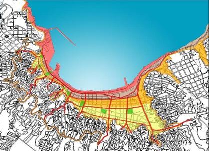
8 GIS DATABASE cooperation with OGP,OREMI, SHOA, FIREMEN CORP cartography aerial photos vulnerability analysis
9 VULNERABILITY


10 URBAN PLANNING Cerro Cordillera pilot area In situ vulnerability investigation restoration proposals cooperation with OGP, UC, Police


11 LASER SCANNER 3D cooperation with GEOCOM, OGP, FIREMEN CORP La Matriz San Francisco Hermanas de la Providencia

12
13 SEISMIC HAZARD Objectives: Hazard at a regional scale Scenario parametric tests Validation with experimental data Seismic input at urban scale 3 selected churches Selected profiles with site effects
 of Chile using the probabilistic approach (see http://www.seismo.")
 and IPGP tectonics lab (R.")
14 SEISMIC HAZARD National scale Seismic hazard map (PGA in m/s 2 with 10% probability of exceedence in 50 years) of Chile using the probabilistic approach (see Map by LIA Montessus de Ballore (CNRS-INSU and Univ. de Chile) and IPGP tectonics lab (R. Lacassin) showing the 2010 event in the context of historical seismicity


15 SEISMIC HAZARD Regional scale Horizontal PGA distribution and Period in seconds of its maximum after hazard deaggregation of the 1906 and 1985 events
16 SEISMIC HAZARD Validation El Almendral station: acceleration, velocity and displacement for the 1985 event. a) computed (unilateral rupture) b) recorded. Comparison of response spectra at UTSFM site: recorded, this study and the one simulated by Somerville et al., 1991.

17 SEISMIC HAZARD Urban scale 71 39' W 71 38' W 71 37' W 71 36' W 71 35' W 33 20' S 33 10' S Intensity XI MCS 33 30' S or IX MSK 71 39' W 71 38' W 71 37' W 71 36' W 71 35' W Groundshaking scenario in the Valparaiso urban area for the 1985 event. NS component of velocities for bilateral rupture.


18 SEISMIC HAZARD Seismic input for 3 selected churches Example of seismic input computed at the La Matriz church: 1906 scenario, unilateral rupture. Displacements, velocities and accelerations for the two horizontal (North South, NS, and East West, EW) components of motion
 at El Almendral and the position")

19 SEISMIC HAZARD Profiles & site effects Bedrock model (depth) at El Almendral and the position of the two profiles with their parameters. Radial component of motion along profile scenario


20 SEISMIC HAZARD Profiles & site effects Spectral amplifications obtained along profile 2. From top to bottom: radial and transverse component.


21 TSUNAMI HAZARD SHOA Inundation maps
22 TSUNAMI HAZARD Earthquake Scenarios We generate a set of tsunami scenarios at the site of Valparaiso, associated to different scenario earthquakes that can be classified, according to their different: a) magnitude, b) occurrence period, Tm, to be intended solely for an engineering analysis, and c) risk level: Magnitude 7.0 Frequent (Tm years) Magnitude 7.5 Occasional (Tm years, Strong) Magnitude 7.8 (1985) Sporadic (Tm years, Very Strong) Magnitude 8.3 (1906) Rare (Tm 500 years, Disastrous) Magnitude 8.5 Exceptional (Tm 1000 years, Catastrophic)
23 TSUNAMI HAZARD Laterally heterogeneous models & Extended sources Tsunami signals for the reference case (1D) and different laterally heterogeneous models (2D). Tsunami signals computed at Valparaiso site (about 50 km) for different magnitudes (from 7.5 to 8.7) considering extended source models. see the NOAA website for real-time modelling of the February 27, 2010 Chile event valparaiso.html
24 TSUNAMI HAZARD Final remarks Using as a base of knowledge the inundation map provided by SHOA (1999) associated to the 1906 event, an upper bound of the multiplication factor for the tsunami hazard associated to be used for the different scenarios can be read in Figure: the tsunami heights, computed with a scaled and an extended source, are plotted versus magnitude and the associated amplifications (using as reference the 1906 level) are shown: a) Maximum height (for point and extended sources) b) amplification compared to the reference event (1906 earthquake) for the scenario earthquakes considered.
25 THE END? The project showed importance and effectiveness of GIS databases in studying historic centers, important for their patrimonial value, prone to natural/anthropic disasters. At the present the methodology has been sufficiently defined in case of earthquake (hazard mapping; building inventory; architectonic/urban planning, structural vulnerability analyses; intervention pro- posals; etc.). It originated important initiatives and further cooperation between Chile and Italy, now in progress, regarding heritage protection. Pure Appl. Geophys. Ó 2010 Springer Basel AG DOI /s Hazard Evaluation in Valparaíso: the MAR VASTO Project MAURIZIO INDIRLI, 1 HOBY RAZAFINDRAKOTO, 2,3 FABIO ROMANELLI, 4 CLAUDIO PUGLISI, 1 LUCA LANZONI, 5 ENRICO MILANI, 6 MARCO MUNARI, 7 and SOTERO APABLAZA 8 Pure and Applied Geophysics Building a culture of prevention is not easy. While the costs of prevention have to be paid in the present, its benefits lie in a distant future. Moreover, the benefits are not tangible; they are the disasters that did NOT happen. Kofi Annan, 1999 (document A/54/1)
A GIS DATABASE FOR THE CITY OF VALPARAISO
 Contract: ENEA Banco Interamericano de Desarrollo (BID)/InterAmerican Development Bank (IDB) Manejo de Riesgos en Valparaiso, Servicios Técnicos Acronym: MAR VASTO ATN/II-9816-CH Contract n. PRM.7.035.00-C
A GIS platform on main natural hazards for Valparaíso city (Chile) and vulnerability studies for some historical constructions and urban sectors
 and vulnerability studies for some historical constructions and urban sectors") Structural Analysis of Historic Construction D Ayala & Fodde (eds) 2008 Taylor & Francis Group, London, ISBN 978-0-415-46872-5 A GIS platform on main natural hazards for Valparaíso city (Chile) and vulnerability
Structural Analysis of Historic Construction D Ayala & Fodde (eds) 2008 Taylor & Francis Group, London, ISBN 978-0-415-46872-5 A GIS platform on main natural hazards for Valparaíso city (Chile) and vulnerability
GENERAL PROGRESS REPORT N 1
 Contract: ENEA Banco Interamericano de Desarrollo (BID)/InterAmerican Development Bank (IDB) Manejo de Riesgos en Valparaiso, Servicios Técnicos Acronym: MAR VASTO ATN/II-9816-CH Contract n. PRM.7.035.00-C
PROTECTING MONUMENTS AND HISTORICAL SETTINGS FROM THE NEXT EARTHQUAKE
 PROTECTING MONUMENTS AND HISTORICAL SETTINGS FROM THE NEXT EARTHQUAKE R.PAPADHMHTRIOU, L.PELLI EUROPEAN CENTER OF PREVENTING & FORECASTING OF EARTHQUAKES Confronting the problem SEISMIC RISK R SEISMIC
PROTECTING MONUMENTS AND HISTORICAL SETTINGS FROM THE NEXT EARTHQUAKE
 PROTECTING MONUMENTS AND HISTORICAL SETTINGS FROM THE NEXT EARTHQUAKE E. PAPADIMITRIOU & L. PELLI EUROPEAN CENTER OF PREVENTING & FORECASTING OF EARTHQUAKES Confronting the problem SEISMIC RISK R SEISMIC
PoS(ISGC 2011 & OGF 31)078
078") Modeling scenarios of earthquake-generated tsunamis for Vietnam coasts Davide Bisignano Università degli Studi di Trieste, Department of Geosciences Via E. Weiss 4, Trieste, Italy E-mail: davide.bisignano@gmail.com
Modeling scenarios of earthquake-generated tsunamis for Vietnam coasts Davide Bisignano Università degli Studi di Trieste, Department of Geosciences Via E. Weiss 4, Trieste, Italy E-mail: davide.bisignano@gmail.com
EARTHQUAKE HAZARD IN THE CITY OF VALPARAISO
 Contract: ENEA Banco Interamericano de Desarrollo (BID)/InterAmerican Development Bank (IDB) Manejo de Riesgos en Valparaiso, Servicios Técnicos Acronym: MAR VASTO ATN/II-9816-CH Contract n. PRM.7.035.00-C
Luca Guerrieri Valerio Comerci Eutizio Vittori
 Earthquake Environmental Effects induced by the 1908 December 28 th Messina earthquake: an in-situ contribute to the Messina supersite (GEO Task DI-09-01a Vulnerability Mapping and Risk Assessment Luca
The Role of Science and Technology in Earthquake Hazard Characterization: A Chilean Experience
 The Role of Science and Technology in Earthquake Hazard Characterization: A Chilean Experience STI Contribution to Policy Making on Natural Disaster Resilience APEC Workshop, 1-2 August 2018 Santiago -
Between Seismology and Seismic Design
 Between Seismology and Seismic Design Prof. Dipartimento di Ingegneria Civile e Ambientale, Politecnico di Milano Milano, 10 dicembre 2013 Outline 2 Seismic hazard analysis for critical facilities SIGMA
Application of a GIS for Earthquake Hazard Assessment and Risk Mitigation in Vietnam
 Application of a GIS for Earthquake Hazard Assessment and Risk Mitigation in Vietnam Nguyen Hong Phuong Earthquake Information and Tsunami Warning Centre, VAST OUTLINE Introduction Fault Source Model and
GROUND MOTION TIME HISTORIES FOR THE VAN NUYS BUILDING
 GROUND MOTION TIME HISTORIES FOR THE VAN NUYS BUILDING Prepared for the PEER Methodology Testbeds Project by Paul Somerville and Nancy Collins URS Corporation, Pasadena, CA March 7, Site Conditions The
OVERVIEW OF THE VESUVIUS CASE STUDY ACTIVITY
 M. Indirli, ENEA, Bologna, Italy VESUVIUS SPECIAL SESSION OVERVIEW OF THE VESUVIUS CASE STUDY ACTIVITY The VESUVIUS case study in the framework of the EU COST Action C26 activity In the Delft meeting (November
THE RESPONSE SPECTRUM
 (NBCC 25) Gail M. The Canadian Society for Civil Engineering, Vancouver Section THE RESPONSE SPECTRUM Seismic Hazard Analysis to obtain Uniform Hazard Response Spectrum (NBCC 25) Gail M. Department of
PRELIMINARY STUDY OF THE 2011 JAPAN EARTHQUAKE (M 9.0) GROUND MOTION RECORDS V1.01
 GROUND MOTION RECORDS V1.01") Cite as: F. De Luca, E. Chioccarelli, I. Iervolino (), Preliminary study of the Japan earthquake ground motion record V., available at http://www.reluis.it. PRELIMINARY STUDY OF THE JAPAN EARTHQUAKE (M
Cite as: F. De Luca, E. Chioccarelli, I. Iervolino (), Preliminary study of the Japan earthquake ground motion record V., available at http://www.reluis.it. PRELIMINARY STUDY OF THE JAPAN EARTHQUAKE (M
Pacific Catastrophe Risk Assessment And Financing Initiative
 Pacific Catastrophe Risk Assessment And Financing Initiative PALAU September is expected to incur, on average,.7 million USD per year in losses due to earthquakes and tropical cyclones. In the next 5 years,
Japan Seismic Hazard Information Station
 Japan Seismic Hazard Information Station (J-SHIS) Hiroyuki Fujiwara National Research Institute for Earth Science and Disaster Prevention (NIED) Background of the Project Headquarters for Earthquake Research
Earthquakes. Earthquake Magnitudes 10/1/2013. Environmental Geology Chapter 8 Earthquakes and Related Phenomena
 Environmental Geology Chapter 8 Earthquakes and Related Phenomena Fall 2013 Northridge 1994 Kobe 1995 Mexico City 1985 China 2008 Earthquakes Earthquake Magnitudes Earthquake Magnitudes Richter Magnitude
I. Locations of Earthquakes. Announcements. Earthquakes Ch. 5. video Northridge, California earthquake, lecture on Chapter 5 Earthquakes!
 51-100-21 Environmental Geology Summer 2006 Tuesday & Thursday 6-9:20 p.m. Dr. Beyer Earthquakes Ch. 5 I. Locations of Earthquakes II. Earthquake Processes III. Effects of Earthquakes IV. Earthquake Risk
Site effect studies in Khorog (Tajikistan)
") Marco Pilz, Dino Bindi, Bolot Moldobekov, Sagynbek Orunbaev, Shahid Ullah, Stefano Parolai Site effect studies in Khorog (Tajikistan) Scientific Technical Report STR14/10 www.gfz-potsdam.de Recommended
Marco Pilz, Dino Bindi, Bolot Moldobekov, Sagynbek Orunbaev, Shahid Ullah, Stefano Parolai Site effect studies in Khorog (Tajikistan) Scientific Technical Report STR14/10 www.gfz-potsdam.de Recommended
Initiative. Country Risk Profile: papua new guinea. Better Risk Information for Smarter Investments PAPUA NEW GUINEA.
 Pacific Catastrophe Risk Assessment And Financing Initiative PAPUA NEW GUINEA September 211 Country Risk Profile: papua new is expected to incur, on average, 85 million USD per year in losses due to earthquakes
Overview of Seismic PHSA Approaches with Emphasis on the Management of Uncertainties
 H4.SMR/1645-29 "2nd Workshop on Earthquake Engineering for Nuclear Facilities: Uncertainties in Seismic Hazard" 14-25 February 2005 Overview of Seismic PHSA Approaches with Emphasis on the Management of
Earthquakes and Faulting
 Earthquakes and Faulting Crustal Strength Profile Quakes happen in the strong, brittle layers Great San Francisco Earthquake April 18, 1906, 5:12 AM Quake lasted about 60 seconds San Francisco was devastated
Three Fs of earthquakes: forces, faults, and friction. Slow accumulation and rapid release of elastic energy.
 Earthquake Machine Stick-slip: Elastic Rebound Theory Jerky motions on faults produce EQs Three Fs of earthquakes: forces, faults, and friction. Slow accumulation and rapid release of elastic energy. Three
Interpretive Map Series 24
 Oregon Department of Geology and Mineral Industries Interpretive Map Series 24 Geologic Hazards, and Hazard Maps, and Future Damage Estimates for Six Counties in the Mid/Southern Willamette Valley Including
Seismic hazard analysis and microzonation of Coimbatore Corporation
 Indian Journal of Geo Marine Sciences Vol.46 (11), November 2017, pp. 2207-2214 Seismic hazard analysis and microzonation of Coimbatore Corporation K E Viswanathan 1 & K Elangovan 2 1 Department of Civil
GROUND MOTION TIME HISTORIES FOR THE VAN NUYS BUILDING
 GROUND MOTION TIME HISTORIES FOR THE VAN NUYS BUILDING Prepared for the PEER Methodology Testbeds Project by Paul Somerville and Nancy Collins URS Corporation, Pasadena, CA. Preliminary Draft, Feb 11,
Definitions. Seismic Risk, R (Σεισμική διακινδύνευση) = risk of damage of a structure
 = risk of damage of a structure") SEISMIC HAZARD Definitions Seismic Risk, R (Σεισμική διακινδύνευση) = risk of damage of a structure Seismic Hazard, Η (Σεισμικός κίνδυνος) = expected intensity of ground motion at a site Vulnerability,
SEISMIC HAZARD Definitions Seismic Risk, R (Σεισμική διακινδύνευση) = risk of damage of a structure Seismic Hazard, Η (Σεισμικός κίνδυνος) = expected intensity of ground motion at a site Vulnerability,
Pacific Catastrophe Risk Assessment And Financing Initiative
 Pacific Catastrophe Risk Assessment And Financing Initiative VANUATU September 211 Country Risk Profile: VANUATU is expected to incur, on average, 48 million USD per year in losses due to earthquakes and
Pacific Catastrophe Risk Assessment And Financing Initiative
 Pacific Catastrophe Risk Assessment And Financing Initiative TIMOR-LESTE September Timor-Leste is expected to incur, on average, 5.9 million USD per year in losses due to earthquakes and tropical cyclones.
20 and 29 May events. Luigi Petti, Alessio Lodato
 PRELIMINARY SPATIAL ANALYSIS AND COMPARISON BETWEEN RESPONSE SPECTRA EVALUATED FOR EMILIA ROMAGNA EARTHQUAKES AND ELASTIC DEMAND SPECTRA ACCORDING TO THE NEW SEISMIC ITALIAN CODE 20 and 29 May events Introduction
Airborne LiDAR and Hyperspectral Data to Support the Seismic Vulnerability of Urban Environments
 Airborne LiDAR and Hyperspectral Data to Support the Seismic Vulnerability of Urban Environments Antonio Costanzo 1, Antonio Montuori 1, Juan Pablo Silva 2, Malvina Silvestri 3, Massimo Musacchio 3, Maria
ENGINEERING-SEISMOLOGICAL ASPECTS OF EARTHQUAKE SCENARIO DEVELOPMENT ON THE EXAMPLE OF TASHKENT, UZBEKISTAN
 International Journal of Geology, Earth & Environmental Sciences ISSN: 2277-281 (Online) 218 Vol. 8 (2) May-August, pp. 3-35/Alixanovich ENGINEERING-SEISMOLOGICAL ASPECTS OF EARTHQUAKE SCENARIO DEVELOPMENT
Pacific Catastrophe Risk Assessment And Financing Initiative
 Pacific Catastrophe Risk Assessment And Financing Initiative TUVALU is expected to incur, on average,. million USD per year in losses due to earthquakes and tropical cyclones. In the next 5 years, has
Multi-Hazard Mitigation of Risks to Cultural Heritage
 Indo-Italian Joint Workshop on: Multi-Hazard Mitigation of Risks to Cultural Heritage 4-5 December 2017, Senate Hall, IIT Delhi Organised by: Indian Institute of Technology, Jodhpur Embassy of Italy, New
Understanding Seismic Hazard Needs for Infrastructure Risk Analysis: Lessons from SYNER-G
 Systemic Seismic Vulnerability and Risk Analysis for Buildings, Lifeline Networks and Infrastructures Safety Gain Understanding Seismic Hazard Needs for Infrastructure Risk Analysis: Lessons from SYNER-G
Multi-Hazard Mitigation of Risks to Cultural Heritage
 Indo-Italian Joint Workshop on: Multi-Hazard Mitigation of Risks to Cultural Heritage 4-5 December 2017, Senate Hall, IIT Delhi Organised by: Department of Science and Technology, Government of India,
IGOS Geohazards: toward an improved use of Earth Observations for Geohazards mitigation
 IGOS Geohazards: toward an improved use of Earth Observations for Geohazards mitigation Scientific and Technical Subcommittee session Vienna, 15th February 2007 Gonéri Le Cozannet IGOS Geohazards Bureau
Accelerograms for building design for hard soil in Mexico City
 Earthquake Resistant Engineering Structures V 23 Accelerograms for building design for hard soil in Mexico City M. A. Jaimes Téllez, E. Reinoso Angulo & M. Ordaz Schroeder Engineering Institute, UNAM,
Development of U. S. National Seismic Hazard Maps and Implementation in the International Building Code
 Development of U. S. National Seismic Hazard Maps and Implementation in the International Building Code Mark D. Petersen (U.S. Geological Survey) http://earthquake.usgs.gov/hazmaps/ Seismic hazard analysis
Landslide Hazard Assessment Methodologies in Romania
 A Scientific Network for Earthquake, Landslide and Flood Hazard Prevention SciNet NatHazPrev Landslide Hazard Assessment Methodologies in Romania In the literature the terms of susceptibility and landslide
Low-Latency Earthquake Displacement Fields for Tsunami Early Warning and Rapid Response Support
 Low-Latency Earthquake Displacement Fields for Tsunami Early Warning and Rapid Response Support Hans-Peter Plag, Geoffrey Blewitt Nevada Bureau of Mines and Geology and Seismological Laboratory University
EARTHQUAKE HAZARD ASSESSMENT IN KAZAKHSTAN
 EARTHQUAKE HAZARD ASSESSMENT IN KAZAKHSTAN Dr Ilaria Mosca 1 and Dr Natalya Silacheva 2 1 British Geological Survey, Edinburgh (UK) imosca@nerc.ac.uk 2 Institute of Seismology, Almaty (Kazakhstan) silacheva_nat@mail.ru
SEISMIC HAZARD ANALYSIS. Instructional Material Complementing FEMA 451, Design Examples Seismic Hazard Analysis 5a - 1
 SEISMIC HAZARD ANALYSIS Instructional Material Complementing FEMA 451, Design Examples Seismic Hazard Analysis 5a - 1 Seismic Hazard Analysis Deterministic procedures Probabilistic procedures USGS hazard
CHAPTER 3 METHODOLOGY
 32 CHAPTER 3 METHODOLOGY 3.1 GENERAL In 1910, the seismological society of America identified the three groups of earthquake problems, the associated ground motions and the effect on structures. Indeed
1. 1 What hazard maps have been developed in your country?
 REPUBLIC OF SLOVENIA MINISTRY OF DEFENCE ADMINISTRATION FOR CIVIL PROTECTION AND DISASTER RELIEF Kardeljeva plošcad 21, 1000 Ljubljana telephone: (+386) 1 471 33 22, fax: (+386) 1 431 81 17 ANSWERS TO
QUANTITATIVE PROBABILISTIC SEISMIC RISK ANALYSIS OF STORAGE FACILITIES
 QUANTITATIVE PROBABILISTIC SEISMIC RISK ANALYSIS OF STORAGE FACILITIES Antonio Di Carluccio, Iunio Iervolino, Gaetano Manfredi Dip. di Analisi e Progettazione Sismica, Università di Napoli Federico II,
Earthquakes, an overview. Christa G. von Hillebrandt-Andrade Puerto Rico Seismic Network University of PR-Mayagüez
 Earthquakes, an overview Christa G. von Hillebrandt-Andrade Puerto Rico Seismic Network University of PR-Mayagüez Earthquakes?!?!?! Myth #1 The main danger associated with Earthquakes are the fissures
COMPREHENSIVE GIS-BASED SOLUTION FOR ROAD BLOCKAGE DUE TO SEISMIC BUILDING COLLAPSE IN TEHRAN
 COMPREHENSIVE GIS-BASED SOLUTION FOR ROAD BLOCKAGE DUE TO SEISMIC BUILDING COLLAPSE IN TEHRAN B. Mansouri 1, R. Nourjou 2 and K.A. Hosseini 3 1 Assistant Professor, Dept. of Emergency Management, International
DEVELOPMENT OF CARIBBEAN RISK ATLAS FOR EARTHQUAKE HAZARDS (RISK ATLAS PROJECT)
") DEVELOPMENT OF CARIBBEAN RISK ATLAS FOR EARTHQUAKE HAZARDS (RISK ATLAS PROJECT) Walter Salazar, Richard Robertson, Machel Higgins, Cassandra La Barrie, Lloyd Lynch, Joan Latchman, Alia Juman, Jillian Bernard
DEVELOPMENT OF CARIBBEAN RISK ATLAS FOR EARTHQUAKE HAZARDS (RISK ATLAS PROJECT) Walter Salazar, Richard Robertson, Machel Higgins, Cassandra La Barrie, Lloyd Lynch, Joan Latchman, Alia Juman, Jillian Bernard
Guidelines for Site-Specific Seismic Hazard Reports for Essential and Hazardous Facilities and Major and Special-Occupancy Structures in Oregon
 Guidelines for Site-Specific Seismic Hazard Reports for Essential and Hazardous Facilities and Major and Special-Occupancy Structures in Oregon By the Oregon Board of Geologist Examiners and the Oregon
Improvements in research knowledge: a challenge for engineering
 Improvements in research knowledge: a challenge for engineering R. K. H. Falconer Group Manager Natural Hazards Group, Institute of Geological and Nuclear Sciences Ltd NZSEE 2002 Conference ABSTRACT: Research
Strong Ground Motion Attenuation Relations for Chilean Subduction Zone Interface Earthquakes
 Strong Ground Motion Attenuation Relations for Chilean Subduction Zone Interface Earthquakes V. Contreras & R. Boroschek Department of Civil Engineering, University of Chile, Chile SUMMARY: Attenuation
What s New In ASCE 7-16?
 What s New In ASCE 7-16? Ronald O. Hamburger SE, SECB Senior Principal Simpson Gumpertz & Heger Inc. Presented to: TMS San Diego, CA Nov. 4 2017 www.sgh.com The Big Changes Title Change Chapter 1 Performance
Surviving the Big One: Understanding and Preparing for a Major Earthquake in Western Oregon
 Surviving the Big One: Understanding and Preparing for a Major Earthquake in Western Oregon May 21, 2013 City of Salem Salem Public Library Althea Rizzo, Geological Hazards Program Coordinator Oregon Emergency
Long-Period Transition Maps Location of Deterministic Areas
 Seismic Ground Motions GROUND MOTION MAPS How To Obtain the Basic Values 1 Determine basic values from maps for bedrock conditions 2, 3 Classify soil conditions at site and determine site coefficients
AN OVERVIEW AND GUIDELINES FOR PROBABILISTIC SEISMIC HAZARD MAPPING
 CO 2 TRACCS INTERNATIONAL WORKSHOP Bucharest, 2 September, 2012 AN OVERVIEW AND GUIDELINES FOR PROBABILISTIC SEISMIC HAZARD MAPPING M. Semih YÜCEMEN Department of Civil Engineering and Earthquake Studies
Usually, only a couple of centuries of earthquake data is available, much shorter than the complete seismic cycle for most plate motions.
 Earthquake Hazard Analysis estimate the hazard presented by earthquakes in a given region Hazard analysis is related to long term prediction and provides a basis to expressed hazard in probabilistic terms.
The Greek Supersite: An initiative from the most tectonically active part of Europe
 The Greek Supersite: An initiatie from the most tectonically actie part of Europe Alexandros Saaidis, PhD. Institute of Engineering Seismology and Earthquake Engineering, EPPO GEO-XIII Plenary Side Eents
SEISMIC RISK ASSESSMENT IN ARMENIA
 SEISMIC RISK ASSESSMENT IN ARMENIA Hovhannes Khangeldyan Head of National Crisis Management Center Rescue Service Ministry of Emergency Situations of the Republic of Armenia Tokyo, 2016 ARMENIA: GEOGRAPHICAL
Interpretive Map Series 24
 Oregon Department of Geology and Mineral Industries Interpretive Map Series 24 Geologic Hazards, Earthquake and Landslide Hazard Maps, and Future Earthquake Damage Estimates for Six Counties in the Mid/Southern
MEGA-EARTHQUAKES RUPTURE SCENARIOS AND STRONG MOTION SIMULATIONS FOR LIMA, PERU
 Paper No. TS-6-2 MEGA-EARTHQUAKES RUPTURE SCENARIOS AND STRONG MOTION SIMULATIONS FOR LIMA, PERU Nelson PULIDO 1, Hernando TAVERA 2, Zenón AGUILAR 3, Diana CALDERÓN 4, Mohamed CHLIEH 5, Toru SEKIGUCHI
FIRE HAZARD IN THE CITY OF VALPARAISO
 Contract: ENEA Banco Interamericano de Desarrollo (BID)/InterAmerican Development Bank (IDB) Manejo de Riesgos en Valparaiso, Servicios Técnicos Acronym: MAR VASTO ATN/II-9816-CH Contract n. PRM.7.035.00-C
Arthur Frankel, William Stephenson, David Carver, Jack Odum, Robert Williams, and Susan Rhea U.S. Geological Survey
 Probabilistic Seismic Hazard Maps for Seattle: 3D Sedimentary Basin Effects, Nonlinear Site Response, and Uncertainties from Random Velocity Variations Arthur Frankel, William Stephenson, David Carver,
Does MoSE cope with inland tsunamis hazard?!
 Does MoSE cope with inland tsunamis hazard? a,b,c,d a a,b Giuliano Francesco Panza, Davide Bisignano, Fabio Romanelli a Department of Mathematics and Geosciences, University of Trieste, Via Weiss4, 34127,
I. INTRODUCTION II. EARTHQUAKES
 2018 IJSRST Volume 4 Issue 5 Print ISSN: 2395-6011 Online ISSN: 2395-602X Themed Section: Science and Technology Iraq Earthquake Contour Maps Bashair A.R. Mohammed *1, Israa H. Mohammed 2, Tariq N. Ataiwe
Synthetic Near-Field Rock Motions in the New Madrid Seismic Zone
 Synthetic Near-Field Rock Motions in the New Madrid Seismic Zone Genda Chen*, Ph.D., P.E., and Mostafa El-Engebawy Engebawy,, Ph.D. *Associate Professor of Civil Engineering Department of Civil, Architecture
Lessons Learned from Past Tsunamis Warning and Emergency Response
 UNESCO IOC CTIC US NOAA ITIC Regional Training Workshop on Strengthening Tsunami Warning and Emergency Response Standard Operating Procedures and the Development of the ICG/CARIBE-EWS PTWC New Enhanced
On the Horizontal-to-Vertical Spectral Ratio in Sedimentary Basins
 Bulletin of the Seismological Society of America, 90, 4, pp. 1101 1106, August 2000 On the Horizontal-to-Vertical Spectral Ratio in Sedimentary Basins by Zakaria Al Yuncha and Francisco Luzón Abstract
Development of Ground Motion Time Histories for Seismic Design
 Proceedings of the Ninth Pacific Conference on Earthquake Engineering Building an Earthquake-Resilient Society 14-16 April, 2011, Auckland, New Zealand Development of Ground Motion Time Histories for Seismic
International Cooperation on Earthquake Disaster Management to Protect Lives
 Pontificia Universidad Católica de Chile Chile, un país s con múltiples m amenazas International Cooperation on Earthquake Disaster Management to Protect Lives Raúl Alvarez Medel, Pontificia Universidad
Damage scenarios in the Vittorio Veneto town centre (NE Italy)
") Bollettino di Geofisica Teorica ed Applicata Vol. 49, n. 3-4, pp. 505-512; September-December 2008 Damage scenarios in the Vittorio Veneto town centre (NE Italy) A. BERNARDINI 1, D. D AYALA 2, F. MERONI
Bollettino di Geofisica Teorica ed Applicata Vol. 49, n. 3-4, pp. 505-512; September-December 2008 Damage scenarios in the Vittorio Veneto town centre (NE Italy) A. BERNARDINI 1, D. D AYALA 2, F. MERONI
Characterization and modelling of seismic action
 COST C26: Urban Habitat Constructions under Catastrophic Events Final Conference, 16-18 September 2010, Naples, Italy Characterization and modelling of seismic action Report of WG2: Earthquake resistance
Information analysis and risk management by cartography
 Information analysis and risk management by cartography Keiichi ISHIDA ABSG Consulting Inc. Tokyo Japan kishida@absconsulting.co.jp Propose: I propose the usage of cartography as an information analysis
STUDY OF THE ACCELEROGRAM DESTRUCTIVENESS OF NAZCA PLATE SUBDUCTION EARTHQUAKES
 STUDY OF THE ACCELEROGRAM DESTRUCTIVENESS OF NAZCA PLATE SUBDUCTION EARTHQUAKES ABSTRACT : G. Rodolfo Saragoni 1, Maximiliano Astroza 1 and Sergio Ruiz 2 1 Professor, Dept. of Civil Engineering, Universidad
RISK ASSESSMENT COMMUNITY PROFILE NATURAL HAZARDS COMMUNITY RISK PROFILES. Page 13 of 524
 RISK ASSESSMENT COMMUNITY PROFILE NATURAL HAZARDS COMMUNITY RISK PROFILES Page 13 of 524 Introduction The Risk Assessment identifies and characterizes Tillamook County s natural hazards and describes how
Tsunami hazard risk and early warning projects at Global Geophysics Institute, Vietnam
 Tsunami hazard risk and early warning projects at Global Geophysics Institute, Vietnam presented by Dr Kelvin Berryman, GNS Science, New Zealand k.berryman@gns.cri.nz on behalf of Prof. Bui C. Que,, Director
REAL-TIME ASSESSMENT OF EARTHQUAKE DISASTER IN YOKOHAMA BASED ON DENSE STRONG-MOTION NETWORK
 REAL-TIME ASSESSMENT OF EARTHQUAKE DISASTER IN YOKOHAMA BASED ON DENSE STRONG-MOTION NETWORK Saburoh MIDORIKAWA 1 And Susumu ABE 2 SUMMARY This paper describes a system for REal-time Assessment of earthquake
Deterministic Seismic Hazard Assessment of Quetta, Pakistan
 Deterministic Seismic Hazard Assessment of Quetta, Pakistan M.A. Shah Micro Seismic Studies Programme, Islamabad, Pakistan Pakistan Institute of Engineering and Applied Sciences, Islamabad, Pakistan M.
GI Technology for Disaster Management
 GI Technology for Disaster Management 17 th ICC on the Regional Space Applications Programme for Sustainable Development (RESAP) 26 th Nov 2013 Bangkok Thailand Period and time of seasonal in thailand
SMR/ May Simulation Analyses of Tsunami caused by Chilean and Nihon-Kai Chubu Earthquakes at Nuclear Power Plant Sites in Japan
 SMR/1839-2 Workshop on the Physics of Tsunami, Hazard Assessment Methods and Disaster Risk Management (Theories and Practices for Implementing Proactive Countermeasures) 14-18 May 2007 Simulation Analyses
EMERGENCY PLANNING IN NORTHERN ALGERIA BASED ON REMOTE SENSING DATA IN RESPECT TO TSUNAMI HAZARD PREPAREDNESS
 EMERGENCY PLANNING IN NORTHERN ALGERIA BASED ON REMOTE SENSING DATA IN RESPECT TO TSUNAMI HAZARD PREPAREDNESS Barbara Theilen-Willige Technical University of Berlin, Institute of Applied Geosciences Department
GEO-VIII November Geohazard Supersites and Natural Laboratories Progress Report. Document 9
 GEO-VIII 16-17 November 2011 Geohazard Supersites and Natural Laboratories Progress Report Document 9 This document is submitted to GEO-VIII for information. Geohazard Supersites and Natural Laboratories
Probabilistic Earthquake Risk Assessment of Newcastle and Lake Macquarie Part 1 Seismic Hazard.
 Probabilistic Earthquake Risk Assessment of Newcastle and Lake Macquarie Part 1 Seismic Hazard. T. Dhu, D. Robinson, C. Sinadinovski, T. Jones, A. Jones & J. Schneider Geoscience Australia, Canberra, Australia.
Seismic response of SDOF systems under doublet earthquakes. *Saman Yaghmaei-Sabegh 1)
") Seismic response of SDOF systems under doublet earthquakes *Saman Yaghmaei-Sabegh 1) 1) Department of Civil Engineering, University of Tabriz, Tabriz, Iran 1) s_yaghmaei@tabrizu.ac.ir ABSTRACT A single
Seismic response of SDOF systems under doublet earthquakes *Saman Yaghmaei-Sabegh 1) 1) Department of Civil Engineering, University of Tabriz, Tabriz, Iran 1) s_yaghmaei@tabrizu.ac.ir ABSTRACT A single
MINISTRY OF NATURAL RESOURCES AND ENVIRONMENT Vietnam Institute of Geosciences and Mineral Resources (VIGMR)
") MINISTRY OF NATURAL RESOURCES AND ENVIRONMENT (VIGMR) Nguyen Quoc Dinh Representative of VIGMR to Sentinel Asia Awaji, Japan, November 1 st,2018 CONTENTS INTRODUCTION TO VIGMR COOPERATION and CONTRIBUTION
MINISTRY OF NATURAL RESOURCES AND ENVIRONMENT (VIGMR) Nguyen Quoc Dinh Representative of VIGMR to Sentinel Asia Awaji, Japan, November 1 st,2018 CONTENTS INTRODUCTION TO VIGMR COOPERATION and CONTRIBUTION
Copernicus Overview and Emergency Management Service
 Copernicus Overview and Emergency Management Service Frédéric BASTIDE European Commission Open informal session of the United Nations Inter-Agency Meeting on Outer Space Activities 12 March 2013, Geneva
Probabilistic Seismic Hazard Maps in Dam Foundation
 Probabilistic Seismic Hazard Maps in Dam Foundation by Hideaki Kawasaki 1, Masafumi Kondo 2, Akira Nakamura 3, Kenji Inagaki 4 ABSTRACT Because Japan is one of the world s most earthquake prone countries,
Seismic Evaluation of Auxiliary Buildings and Effects of 3D Locational Dynamic Response in SPRA
 Seismic Evaluation of Auxiliary Buildings and Effects of 3D Locational Dynamic Response in SPRA PSA 2017, Pittsburgh September 25 th, 2017 Brian Cohn Jieun Hur, Eric Althoff, Halil Sezen, and Richard Denning
Scenario Earthquakes for Korean Nuclear Power Plant Site Considering Active Faults
 Transactions of the 7 th International Conference on Structural Mechanics in Reactor Technology (SMiRT 7) Prague, Czech Republic, August 7 22, 2003 Paper # K03-2 Scenario Earthquakes for Korean Nuclear
Preliminary Earthquake Risk Management Strategy Plan of Eskisehir, Turkey by using GIS
 Preliminary Earthquake Risk Management Strategy Plan of Eskisehir, Turkey by using GIS Metin Altan, Ferah Özturk and Can Ayday Space and Satellite Sciences Research Institute Anadolu University, TURKEY
Earthquake Hazards. Tsunami
 Earthquake Hazards Tsunami Measuring Earthquakes Two measurements that describe the power or strength of an earthquake are: Intensity a measure of the degree of earthquake shaking at a given locale based
Probabilistic Seismic Hazard Analysis in Thailand and Adjacent Areas by Using Regional Seismic Source Zones
 Probabilistic Seismic Hazard Analysis in Thailand and Adjacent Areas by Using Regional Seismic Source Zones Santi Pailoplee 1*, Yuichi Sugiyama 2 and Punya Charusiri 1 1. Earthquake and Tectonic Geology
Emergency Management Service (EMS) mapping
 mapping") GMES Emergency Management Service (EMS) mapping Frédéric BASTIDE GMES unit, European Commission UN-SPIDER Expert Meeting: "Crowdsource Mapping for Disaster Risk Management and Emergency Response" 3-5 December,
GMES Emergency Management Service (EMS) mapping Frédéric BASTIDE GMES unit, European Commission UN-SPIDER Expert Meeting: "Crowdsource Mapping for Disaster Risk Management and Emergency Response" 3-5 December,
THESSALONIKI SEISMIC HAZARD ASSESSMENT: PROBABILISTIC AND DETERMINISTIC APPROACH FOR ROCK SITE CONDITIONS
 4 th International Conference on Earthquake Geotechnical Engineering June 25-28, 27 Paper No. 171 THESSALONIKI SEISMIC HAZARD ASSESSMENT: PROBABILISTIC AND DETERMINISTIC APPROACH FOR ROCK SITE CONDITIONS
Volcanic risk and civil protection implications in Italy
 1st IAVCEI/GVM workshop From volcanic hazard to risk assessment Volcanic risk and civil protection implications in Italy Geneve, 27 28 June 2018 Domenico Mangione and Chiara Cristiani National Civil Protection
Estimation of Peak Ground Acceleration for Delhi Region using Finsim, a Finite Fault Simulation Technique
 215 Estimation of Peak Ground Acceleration for Delhi Region using Finsim, a Finite Fault Simulation Technique NEELIMA SATYAM. D* and K. S. RAO** * Earthquake Engineering Research Centre, International
Geotechnical Site Classification and Croatian National Annex for EC 8
 Geotechnical Site Classification and Croatian National Annex for EC 8 by Predrag Kvasnika University of Zagreb Faculty of Mining-Geology and Petroleum engineering Outline General Motivation Site classification
IDENTIFICATION OF HAZARDS OF CONCERN
 IDENTIFICATION OF HAZARDS OF CONCERN To provide a strong foundation for mitigation strategies considered in Section 6, the Village considered a full range of hazards that could impact the area and then
The Third UN-GGIM-AP Plenary Meeting. Use of Geospatial Information in Disaster and Coordination among NDMA and Relevant Organizations/Stakeholders
 The Third UN-GGIM-AP Plenary Meeting Use of Geospatial Information in Disaster and Coordination among NDMA and Relevant Organizations/Stakeholders Bali Indonesia 10 November 2014 Bernardus Wisnu Widjaja