Hosgri-San Simeon Fault Zone Geologic Slip Rate
|
|
|
- Beverly Grant
- 6 years ago
- Views:
Transcription

1 Hosgri-San Simeon Fault Zone Geologic Slip Rate Insert picture(s) here Kathryn Hanson AMEC E&I Diablo Canyon SSHAC Project SSC Workshop 2 November 7, 2012
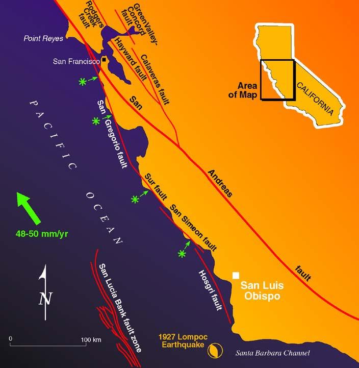
2 What insights have your geologic investigations provided on: The slip rate on the San Simeon fault? The slip rate on the Hosgri fault? The variability of slip rate along strike on the San Gregorio- San Simeon-Hosgri fault system?
3
4 Long-term Slip Historyoffset Mio-Pliocene Strata Modified from Clark et al. (1984) Net Neogene right-lateral slip on SG-SS-H fault system (~156 km) since initiation in late Miocene Dickenson et al. (2005) Evidence for decrease in slip rate (Clark et al. 1999) ~25-30 mm/yr 10-8 Ma 16 mm/yr (8 3 Ma) 6 mm/yr 3 0 Ma
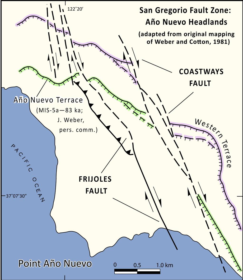
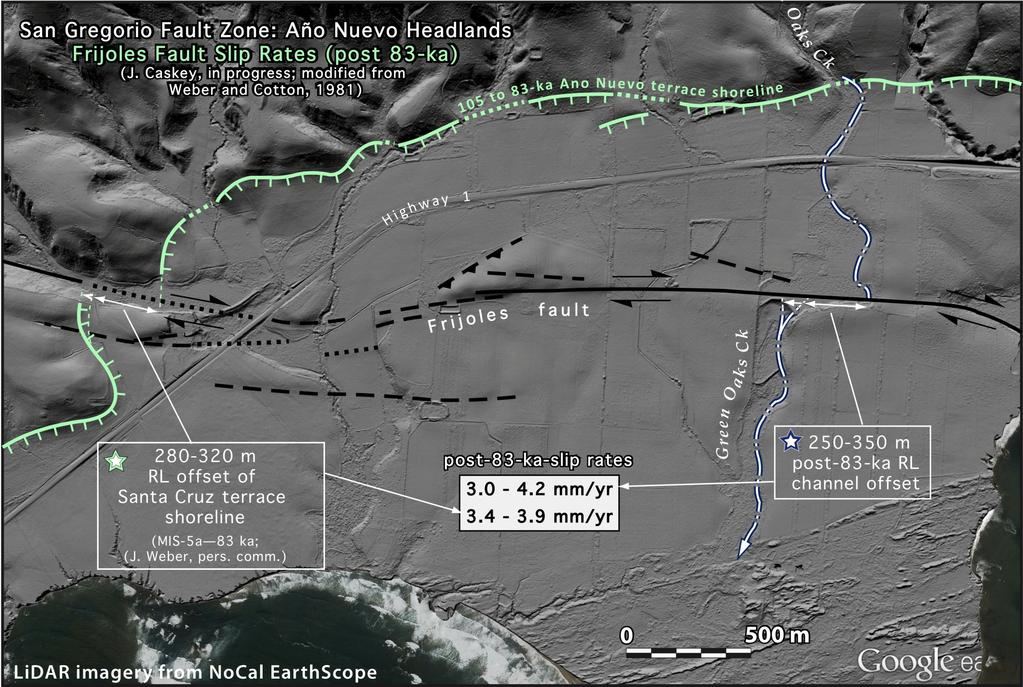
, Aňo Nuevo Locality Weber (1990);Weber et al. (1995); Clark et al.")
5 San Gregorio Paleoseismic Investigations Seal Cove Locality Simpson et al. (1998) Multiple surface rupturing events RL slip rate of 3.5 to 4.5 mm/yr (Seal Cove trace, minimum for zone), Aňo Nuevo Locality Weber (1990);Weber et al. (1995); Clark et al. (1999) Late Pleistocene RL slip rate of 6 to 11 mm/yr (preferred 6-8 mm/yr) John Caskey (person. commun., Nov.2012) Late Pleistocene RL slip rate of 5 mm/yr Quaternary Fault and Fold Database
6
7
8 San Simeon Fault Slip Rate Studies San Simeon Marine Terrace Analysis- Late Pleistocene Slip Rate Hanson and Lettis (1994) Source: Hanson and Lettis (1994, Figure 1) Offset Drainages- Pleistocene Slip Rate Hanson and Lettis (1994) Detailed Marine Terrace Mapping San Simeon Fault Trenching Investigations- Holocene Slip Rate Hall et al. (1994)

9 Marine Terraces Southern Reach of the San Simeon Fault Hanson et al. (1994) and Hanson and Lettis (1994)
10 Terraces Profiles Across San Simeon Fault Source: Hanson et al.(1994)
 0.7 to 2.")
11 Oso Terrace (210 ka) Horizontal Slip Rate (best constrained) 0.7 to 2.6mm/yr Source: Hanson and Lettis (1994)


12 Source: Hanson and Lettis (1994)

13 Quaternary Fault and Fold Database s/
 n 3 Maximum ~6 mm/yr (assumes 3000 m apparent offset of Arroyo de la Cruz channel incised")
 Stream capture-lower Arroyo de los Chinos Minimum 1.0-1.")
14 Deflected Drainages (RL slip rates) n 1 Minimum mm/yr (incision post ka) n 2a & 2b Minimum ~ mm/yr (post and ka) n 3 Maximum ~6 mm/yr (assumes 3000 m apparent offset of Arroyo de la Cruz channel incised into oldest marine terrace ( 480 ka) is due to slip on major trace of San Simeon fault) n 6 - n 8 Minimum 1.6 mm/yr (east and west strands) Stream capture-lower Arroyo de los Chinos Minimum mm/yr (500 m of post ka offset) Source: Hanson and Lettis (1994)
15 LTSP Trench Investigations
 0.9 and 3.")
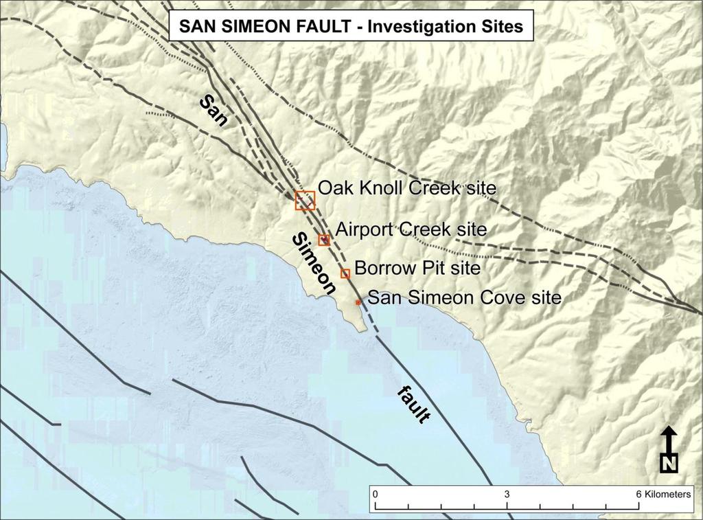
16 Airport Creek Site Both walls of Airport Creek channel show RL deflection of 1.8 m; Interpreted as one or two slip events. Trenches exposed major ~vertical N40ºW striking fault; slickenlines rake of 6-7 SE. Poorly constrained offset of younger terrace margin ( ) 0.9 and 3.4 mm/yr Offset basal gravel of Airport Terrace 16 to 28 m since ~ ka 1.1 to 2.9 mm/yr Geometric analysis of vertically separated soil horizons in T to 3.0 mm/yr 1.0 to 1.4 mm/yr (preferred) Source: Hall et al. (1994)
17 Are there other structures west of the San Simeon fault that are accommodating shortening/ distributed shear that may contribute additional slip to the Hosgri fault zone? Source: Response to Question GSG Q13-2 (PG&E, 1990)

18 Source: Response to Question GSG Q13-2 (PG&E, 1990)
19 Source: Response to Question GSG Q13-2 (PG&E, 1990)
 1-3 mm/yr RL San Simeon fault slip rate transferred to northern Hosgri fault zone 1-3 mm/yr")
20 San Simeon-Hosgri Stepover Basin (PG&E, 1988; Hanson et al. 2005) 1-3 mm/yr RL San Simeon fault slip rate transferred to northern Hosgri fault zone 1-3 mm/yr 1-3 mm/yr Source: Hanson et al. (2004)
 36 1-3 mm/yr 0-2 mm/yr Tectonic Setting Right-lateral shear couple 34")
21 6-8 mm/yr ( 5 mm/yr) Modified from Lettis et al.(2009 ) mm/yr 0-2 mm/yr Tectonic Setting Right-lateral shear couple 34 Wrench-style deformation pattern
22 References Clark, J.C, Brabb, E.E., Greene, H.G, and Ross, D.C, 1984, Geology of Point Reyes Peninsula and implications for San Gregorio fault history, in Crouch, J.K., and Bachman, S.B., eds., Tectonics and Sedimentation along the California Margin: Pacific Section S.E.P.M., vol. 38, p Clark, J.C., Weber, G.E., Rosenberg, L.I., and Burnham, K., 1999, Neotectonics of the San Gregorio fault zone, Central Coastal California: Pacific Section AAPG Field Trip Guide, April 28, 1999, p Hall, N.T., Hunt, T.D., and Vaughan, P.R., 1994, Holocene behavior of the San Simeon fault zone, south-central coastal California in Alterman, I.B., McMullen, R.B., Cluff, L.S., and Slemmons, D.B., eds., Seismotectonics of the Central California Coast Ranges: Geological Society of America Special Paper 292. Hanson, K.L., and Lettis, W.R., 1994, Estimated Pleistocene slip rate for the San Simeon fault zone, south-central coastal California: in Alterman, I.B., McMullen, R.B., Cluff, L.S., and Slemmons, D.B. (eds.), Seismotectonics of the Central California Coast Ranges: Geological Society of America Special Paper 292, p Hanson, K. L., Lettis, W. R, McLaren, M. Savage, W.U. and Hall, N.T., 2004, Style and Rate of Quaternary Deformation of the Hosgri Fault Zone, Off-Shore South-Central California: Santa Maria Province Project: U.S. Geological Survey Bulletin, 1995-AA. M.A. Keller,( ed.). Lettis, W. R., Unruh, J., and Hanson, K.L., 2009, Tectonic setting of South Central Coastal California, SSA presentation slides. PG &E, 1990, Response to RAI GSG Q13-2 Piedras Blancas antiform, assessment of orientation, rates, and sense of vergence.
23 References Weber, G. E., 1990, Late Pleistocene slip rates on the San Gregorio fault zone at Point Ano Nuevo, San Mateo County, California, in Griggs, G. B. and Weber, G. E., eds., Coastal Geologic Hazards and Coastal Tectonics, Northern Monterey Bay and Santa Cruz/San Mateo County Coastlines, Field Trip Guide: Association of Engineering Geologists, March 3, 1990, p Weber, G. E., 1990, Late Pleistocene slip rates on the San Gregorio fault zone at Point Ano Nuevo, San Mateo County, California, in Geology and tectonics of the Central California coast region, San Francisco to Monterey, Volume and Guidebook, Garrison, R. E., and others (eds.), Pacific Section, Am. Assoc. Pet. Geol., p Weber, G. E.,Nolan, J.M>, and Zinn, E.K., 1995, Determination of Late Pleistocene-Holocene slip rates along the San Gregorio fault zone, San Mateo Co., CA: U.S. Geological Survey Final Technical Report, National Earthquake Hazard Reduction Program, 52 p..
John Baldwin and Brian Gray Lettis Consultants International, Inc. Alexis Lavine AMEC Josh Goodman and Janet Sowers Fugro Consultants, Inc.
 John Baldwin and Brian Gray Lettis Consultants International, Inc. Alexis Lavine AMEC Josh Goodman and Janet Sowers Fugro Consultants, Inc. December 1, 2011 Pacific Gas & Electric SSHAC Workshop 1 San
8.0 SUMMARY AND CONCLUSIONS
 8.0 SUMMARY AND CONCLUSIONS In November 2008, Pacific Gas and Electric (PG&E) informed the U.S. Nuclear Regulatory Commission (NRC) that preliminary results from the Diablo Canyon Power Plant (DCPP) Long
Overview of Seismic Source Characterization for the Diablo Canyon Power Plant
 Overview of Seismic Source Characterization for the Diablo Canyon Power Plant Steve Thompson (LCI and SSC TI Team), for SWUS GMC Workshop 1, March 19, 2013 Questions from TI Team Summarize tectonic setting.
Diablo Canyon SSHAC Level 3 Study
 1 Diablo Canyon SSHAC Level 3 Study Workshop 1 Summary of SSC Hazard Significant Issues and Data Needed William Lettis November 29 to December 1, 2011 PG&E DCPP SSHAC Study 2 Hosgri Hosgri Location Hosgri
Fault Models SSC TI Team Evaluation Hans AbramsonWard
 1 Fault Models SSC TI Team Evaluation Hans AbramsonWard PG&E DCPP SSHAC Study 2 Outline Constraints on location of active faults: Uplift of ranges Quaternary fault map Constraints on Depth of seismogenic
San Andreas and Other Fault Sources; Background Source
 1 San Andreas and Other Fault Sources; Background Source SSC TI Team Evaluation Steve Thompson Diablo Canyon SSHAC Level 3 PSHA Workshop #3 Feedback to Technical Integration Team on Preliminary Models
PROGRESS REPORT ON THE ANALYSIS OF THE SHORELINE FAULT ZONE, CENTRAL COASTAL CALIFORNIA. Report to the U.S. Nuclear Regulatory Commission January 2010
 PROGRESS REPORT ON THE ANALYSIS OF THE SHORELINE FAULT ZONE, CENTRAL COASTAL CALIFORNIA Report to the U.S. Nuclear Regulatory Commission January 2010 1.0 INTRODUCTION In November 2008, PG&E informed the
John Shaw CRUSTAL DEFORMATION MODEL: OBLIQUE CONVERGENCE IN THE INNER CALIFORNIA BORDERLANDS ACCOMMODATED BY ACTIVE STRIKE-SLIP AND REVERSE FAULTS
 CRUSTAL DEFORMATION MODEL: OBLIQUE CONVERGENCE IN THE INNER CALIFORNIA BORDERLANDS ACCOMMODATED BY ACTIVE STRIKE-SLIP AND REVERSE FAULTS August 2013 SONGS SSC SSHAC Workshop # 2 (August 12-14, 2013) Crustal
Evidence of Tectonic Uplift along the Oceanic Fault near San Simeon, San. Luis Obispo County, California
 i Evidence of Tectonic Uplift along the Oceanic Fault near San Simeon, San Luis Obispo County, California A Senior Project presented to the Faculty of the Earth and Soil Science Department California Polytechnic
A Senior Project. presented to. The Faculty of the College of Agriculture, Food and Environmental Sciences
 1 Relationship of Joint Sets to Folded Diatomite Bedding of the Miguelito Member of the Pismo Formation in Montaña de Oro State Park A Senior Project presented to The Faculty of the College of Agriculture,
Offshore Evidence for Uplift Rate Boundaries. Hans AbramsonWard Diablo Canyon SSHAC SSC Workshop 2 November 7, 2012
 Offshore Evidence for Uplift Rate Boundaries Hans AbramsonWard Diablo Canyon SSHAC SSC Workshop 2 November 7, 2012 Questions asked by the TI team Discuss your ability to distinguish and correlate offshore
Active Tectonics. Earthquakes, Uplift, and Landscape. Edward A. Keller University of California, Santa Barbara
 Prentice Hall Earth Science Series SUB Gottingen 214 80416X, im ^, 2002 A 7883 lllllllilwii Active Tectonics Earthquakes, Uplift, and Landscape Second Edition V Edward A. Keller University of California,
The Monterey Submarine Canyon and Fan
 Chapter 72 The Monterey Submarine Canyon and Fan Monterey Canyon, California, is probably the most studied submarine canyon in the world (Figure 72.1). Since it is typical of many others it is useful as
Earthquake Tectonics and Hazards on the Continents June Recognizing and characterizing strike-slip faults and earthquakes in USA
 2464-4 Earthquake Tectonics and Hazards on the Continents 17-28 June 2013 Recognizing and characterizing strike-slip faults and earthquakes in USA S. G. Wesnousky Univ. of Nevada USA Strike-slip Faults
SYLLABUS Geology 230 Seminar Geology and Tectonic Development of California
 SYLLABUS Geology 230 Seminar Geology and Tectonic Development of California Instructor: Dr. Diane Carlson (carlsondh@csus.edu) Office Phone: 278-6382 Office: Placer Hall 1015 Office Hours: W 10 11:30 a.m.
Geologic Trips San Francisco and the Bay Area
 Excerpt from Geologic Trips San Francisco and the Bay Area by Ted Konigsmark ISBN 0-9661316-4-9 GeoPress All rights reserved. No part of this book may be reproduced without written permission in writing,
Shoreline Fault Zone Report, Section 2 Data Collection Page 2-1
 2. DATA COLLECTION Continued seismic monitoring and the acquisition of high-resolution potential field (magnetics and gravity), seismic reflection, bathymetric, and topographic data have significantly
Overview of the Seismic Source Characterization for the Palo Verde Nuclear Generating Station
 Overview of the Seismic Source Characterization for the Palo Verde Nuclear Generating Station Scott Lindvall SSC TI Team Lead Palo Verde SSC SSHAC Level 3 Project Tuesday, March 19, 2013 1 Questions from
DCPP Seismic FAQ s Geosciences Department 08/04/2011 GM1) What magnitude earthquake is DCPP designed for?
 What magnitude earthquake is DCPP designed for?") GM1) What magnitude earthquake is DCPP designed for? The new design ground motions for DCPP were developed after the discovery of the Hosgri fault. In 1977, the largest magnitude of the Hosgri fault was
GM1) What magnitude earthquake is DCPP designed for? The new design ground motions for DCPP were developed after the discovery of the Hosgri fault. In 1977, the largest magnitude of the Hosgri fault was
Activity Pacific Northwest Tectonic Block Model
 Activity Pacific Northwest Tectonic Block Model The Cascadia tectonic margin is caught between several tectonic forces, during the relentless motions of the giant Pacific Plate, the smaller subducting
Structural Geology and Tectonics EPS116
 Structural Geology and Tectonics Field Trip and Lab Exercise #7: The San Gregorio fault zone near Half Moon Bay (Pillar Point, Moss Beach and Montara Beach) What to do before the field trip: You will need
Kinematics of the Southern California Fault System Constrained by GPS Measurements
 Title Page Kinematics of the Southern California Fault System Constrained by GPS Measurements Brendan Meade and Bradford Hager Three basic questions Large historical earthquakes One basic question How
PALEOSEISMOLOGY: SITES (17)
") GG 454 February 8, 2002 1 PALEOSEISMOLOGY: SITES (17) Schedule Updates and Reminders: Reading for this lecture: Big Picture - Skim "Applications" in PP 1360 Reading for next lecture: Handouts from Active
GG 454 February 8, 2002 1 PALEOSEISMOLOGY: SITES (17) Schedule Updates and Reminders: Reading for this lecture: Big Picture - Skim "Applications" in PP 1360 Reading for next lecture: Handouts from Active
Earth Science, (Tarbuck/Lutgens) Chapter 10: Mountain Building
 Chapter 10: Mountain Building") Earth Science, (Tarbuck/Lutgens) Chapter 10: Mountain Building 1) A(n) fault has little or no vertical movements of the two blocks. A) stick slip B) oblique slip C) strike slip D) dip slip 2) In a(n) fault,
Earth Science, (Tarbuck/Lutgens) Chapter 10: Mountain Building 1) A(n) fault has little or no vertical movements of the two blocks. A) stick slip B) oblique slip C) strike slip D) dip slip 2) In a(n) fault,
Description of faults
 GLG310 Structural Geology Description of faults Horizontal stretch Crustal thickness Regional elevation Regional character Issues Normal Thrust/reverse Strike-slip >1 1 in one direction and < 1 in
GPS Strain & Earthquakes Unit 5: 2014 South Napa earthquake GPS strain analysis student exercise
 GPS Strain & Earthquakes Unit 5: 2014 South Napa earthquake GPS strain analysis student exercise Strain Analysis Introduction Name: The earthquake cycle can be viewed as a process of slow strain accumulation
depression above scarp scarp
 1 LAB 1: FIELD TRIP TO McKINLEYVILLE AND MOUTH OF THE MAD RIVER OBJECTIVES: a. to look at geomorphic and geologic evidence for large scale thrust-faulting of young sediments in the Humboldt Bay region
SCEC Earthquake Gates Workshop Central Death Valley Focus Area
 SCEC Earthquake Gates Workshop Central Death Valley Focus Area Fault Gates: Rheology, fault geometry, stress history or directionality? How do we recognize or suspect a fault gate? Paleoseismic or historic
Deformation History of a Major Restraining Bend along a Right-Slip Fault: The San Clemente Fault Offshore Northern Baja California, Mexico
 Deformation History of a Major Restraining Bend along a Right-Slip Fault: The San Clemente Fault Offshore Northern Baja California, Mexico REPORT The main focus of this project was to investigate the deformation
Table S1. Different scenarios of terrace ages and their resultant predicted MIS 5c and MIS 5a sea-level
 DR2015257 GSA Data Repository Table S1. Different scenarios of terrace ages and their resultant predicted MIS 5c and MIS 5a sea-level elevations at Santa Cruz, California. Figure S1. Predictions of GIA
S. Toda, S. Okada, D. Ishimura, and Y. Niwa International Research Institute of Disaster Science, Tohoku University, Japan
 The first surface-rupturing earthquake in 20 years on a HERP major active fault: Mw=6.2 2014 Nagano, Japan, event along the Itoigawa-Shizuoka Tectonic Line is not characteristic S. Toda, S. Okada, D. Ishimura,
Mark Legg COASTAL DEFORMATION AND TECTONIC EVOLUTION OFFSHORE SAN ONOFRE
 COASTAL DEFORMATION AND TECTONIC EVOLUTION OFFSHORE SAN ONOFRE August 2013 Coastal Deformation and Tectonic Evolution Offshore San Onofre Mark R. Legg Legg Geophysical, Inc. The true sign of intelligence
Hosgri Fault Location and Dip SSC TI Team Evaluation Hans AbramsonWard
 1 Hosgri Fault Location and Dip SSC TI Team Evaluation Hans AbramsonWard PG&E DCPP SSHAC Study 2 Key Data Sources PE Models: Johnson WS2 presentation Hardebeck WS2 presentation Watt WS2 presentation AbramsonWard
SONGS SSC. Tom Freeman GeoPentech PRELIMINARY RESULTS
 SONGS SSC Tom Freeman GeoPentech PRELIMINARY RESULTS Focused Questions Summarize the tectonic setting What is the seismogenic thickness? Are you including deep ruptures in the upper mantle (~30 km)? Do
RECORD OF REVISIONS Rev. Reason for Revision 0 Initial Report. This worked is tracked under SAPNs (Greene) and Graham ( )
 and Graham ( )") Page 2 of 178 RECORD OF REVISIONS Rev. No. Reason for Revision 0 Initial Report. This worked is tracked under SAPNs 505100993 (Greene) and Graham (50533445) Revision Date 7/27/2014 Page 3 of 178 TABLE
Page 2 of 178 RECORD OF REVISIONS Rev. No. Reason for Revision 0 Initial Report. This worked is tracked under SAPNs 505100993 (Greene) and Graham (50533445) Revision Date 7/27/2014 Page 3 of 178 TABLE
Structural deformation across the southwest Mina deflection, California-Nevada: Field studies in the Huntoon Springs area.
 Structural deformation across the southwest Mina deflection, California-Nevada: Field studies in the Huntoon Springs area. Eliya R. Hogan Advisor: Jeff Lee Introduction and purpose of study: The Mina deflection
WESTERN STATES SEISMIC POLICY COUNCIL POLICY RECOMMENDATION Definitions of Recency of Surface Faulting for the Basin and Range Province
 WESTERN STATES SEISMIC POLICY COUNCIL POLICY RECOMMENDATION 15-3 Definitions of Recency of Surface Faulting for the Basin and Range Province Policy Recommendation 15-3 WSSPC recommends that each state
4.10 GEOLOGY, SOILS, AND SEISMICITY
 4.10 GEOLOGY, SOILS, AND SEISMICITY 4.10.1 INTRODUCTION This section describes the geology of the SVRTC and the susceptibility of site soils to seismically induced hazards. Faults in the corridor and past
Regional deformation and kinematics from GPS data
 Regional deformation and kinematics from GPS data Jessica Murray, Jerry Svarc, Elizabeth Hearn, and Wayne Thatcher U. S. Geological Survey Acknowledgements: Rob McCaffrey, Portland State University UCERF3
DAY 1 (Nov. 6, 2012) Technical Presentations
 Technical Presentations") Presentation Sam Johnson Jeanne Hardebeck DAY 1 (Nov. 6, 2012) Technical Presentations Key points/action items : Consider vertical rates as transitory and localized Review Mann publications and consider
Presentation Sam Johnson Jeanne Hardebeck DAY 1 (Nov. 6, 2012) Technical Presentations Key points/action items : Consider vertical rates as transitory and localized Review Mann publications and consider
Geo736: Seismicity and California s Active Faults Introduction
 Geo736: Seismicity and California s Active Faults Course Notes: S. G. Wesnousky Spring 2018 Introduction California sits on the boundary of the Pacific - North American plate boundary (Figure 1). Relative
EARTHQUAKE LOCATIONS INDICATE PLATE BOUNDARIES EARTHQUAKE MECHANISMS SHOW MOTION
 6-1 6: EARTHQUAKE FOCAL MECHANISMS AND PLATE MOTIONS Hebgen Lake, Montana 1959 Ms 7.5 1 Stein & Wysession, 2003 Owens Valley, California 1872 Mw ~7.5 EARTHQUAKE LOCATIONS INDICATE PLATE BOUNDARIES EARTHQUAKE
UNITED STATES NUCLEAR REGULATORY COMMISSION WASHINGTON, D.C January 11, 2016
 UNITED STATES NUCLEAR REGULATORY COMMISSION WASHINGTON, D.C. 20555-0001 Mr. Edward D. Halpin Senior Vice President and Chief Nuclear Officer Pacific Gas and Electric Company P.O. Box 56 Mail Code 104/6
Correlation of gravel deposits from trenching project on Alder Creek fluvial terrace near Point Arena, California
 Correlation of gravel deposits from trenching project on Alder Creek fluvial terrace near Point Arena, California Aletha Lee Department of Geology and Geography, West Virginia University, White Hall, Morgantown,
Structural Geology and Geology Maps Lab
 Structural Geology and Geology Maps Lab Mesa College Geology 101 Lab Ray Rector: Instructor Structural Geology Lab Pre-Lab Resources Pre-Lab Internet Links 1) Fundamentals of Structural Geology 2) Visualizing
Learning goals - January 16, Describe the geometry of a fault (1) orientation of the plane (strike and dip) (2) slip vector
 orientation of the plane (strike and dip) (2) slip vector") Learning goals - January 16, 2012 You will understand how to: Describe the geometry of a fault (1) orientation of the plane (strike and dip) (2) slip vector Understand concept of slip rate and how it is
Learning goals - January 16, 2012 You will understand how to: Describe the geometry of a fault (1) orientation of the plane (strike and dip) (2) slip vector Understand concept of slip rate and how it is
DIRECT HAZARD ANALYSIS OF INELASTIC RESPONSE SPECTRA
 DIRECT HAZARD ANALYSIS OF INELASTIC RESPONSE SPECTRA ABSTRACT Y. Bozorgnia, M. Hachem, and K.W. Campbell Associate Director, PEER, University of California, Berkeley, California, USA Senior Associate,
Late Holocene Slip Rate and Ages of Prehistoric Earthquakes along the Maacama Fault Near Willits, Mendocino County, Northern California
 Bulletin of the Seismological Society of America, Vol. 104, No. 6, pp., December 2014, doi: 10.1785/0120140003 E Late Holocene Slip Rate and Ages of Prehistoric Earthquakes along the Maacama Fault Near
Description of faults
 GLG310 Structural Geology Description of faults Horizontal stretch Crustal thickness Regional elevation Regional character Issues Normal Thrust/reverse Strike-slip >1 1 in one direction and < 1 in
TABLE OF CONTENTS Page
 Page 1 of 24 TABLE OF CONTENTS Page Lists of Tables and Figures... 2 Abbreviations and Acronyms... 3 1.0 INTRODUCTION... 4 1.1 Geologic Setting... 4 1.2 CCCSIP Project Selection... 5 1.3 Organization of
Summer 2014 Reading the Geologic History of Doheny State Beach Rodger More LAYERS LET S TAKE A TOUR THE BLUFFS
 Summer 2014 Reading the Geologic History of Doheny State Beach Rodger More DSBIA Board Officer and Geologist (retired) LAYERS of sediment and rock are like a book. Formations make up chapters and individual
Geology (Mellow) Hike, Santa Lucia Memorial Park February 16, I. Overview of Santa Lucia Range geology and tectonic history
 Hike, Santa Lucia Memorial Park February 16, I. Overview of Santa Lucia Range geology and tectonic history") Geology (Mellow) Hike, Santa Lucia Memorial Park February 16, 2015 I. Overview of Santa Lucia Range geology and tectonic history A. Basement Rocks 1. Salinian Block Rocks Sierra Nevada Type, continental
Geology (Mellow) Hike, Santa Lucia Memorial Park February 16, 2015 I. Overview of Santa Lucia Range geology and tectonic history A. Basement Rocks 1. Salinian Block Rocks Sierra Nevada Type, continental
Hints of active deformation in the southern Adriatic foreland: Holocene tectonics along the Apulia offshore (Italy)
") Hints of active deformation in the southern Adriatic foreland: Holocene tectonics along the Apulia offshore (Italy) Domenico Ridente^, Umberto Fracassi*, Daniela Di Bucci, Fabio Trincardi^ ^ & Gianluca
Hints of active deformation in the southern Adriatic foreland: Holocene tectonics along the Apulia offshore (Italy) Domenico Ridente^, Umberto Fracassi*, Daniela Di Bucci, Fabio Trincardi^ ^ & Gianluca
Crustal Deformation Earth - Chapter Pearson Education, Inc.
 Crustal Deformation Earth - Chapter 10 Structural Geology Structural geologists study the architecture and processes responsible for deformation of Earth s crust. A working knowledge of rock structures
Study on the feature of surface rupture zone of the west of Kunlunshan pass earthquake ( M S 811) with high spatial resolution satellite images
 with high spatial resolution satellite images") 48 2 2005 3 CHINESE JOURNAL OF GEOPHYSICS Vol. 48, No. 2 Mar., 2005,,. M S 811.,2005,48 (2) :321 326 Shan X J, Li J H, Ma C. Study on the feature of surface rupture zone of the West of Kunlunshan Pass
48 2 2005 3 CHINESE JOURNAL OF GEOPHYSICS Vol. 48, No. 2 Mar., 2005,,. M S 811.,2005,48 (2) :321 326 Shan X J, Li J H, Ma C. Study on the feature of surface rupture zone of the West of Kunlunshan Pass
FINAL TECHNICAL REPORT
 FINAL TECHNICAL REPORT Digital Compilation of Thrust and Reverse Fault Data for the Northern California Map Database: Collaborative Research with William Lettis & Associates, Inc., and the U.S. Geological
SEISMIC-HAZARD ASSESSMENT: Conditional Probability
 Conditional Probability SEISMIC-HAZARD ASSESSMENT: Conditional Probability Supplies Needed calculator PURPOSE Previous exercises in this book have outlined methods for inferring the patterns and history
Meandering Miocene Deep Sea Channel Systems Offshore Congo, West Africa
 Meandering Miocene Deep Sea Channel Systems Offshore Congo, West Africa S. Baer* (PGS), J. E. Comstock (PGS), K. Vrålstad (PGS), R. Borsato (PGS), M. Martin (PGS), J.P. Saba (SNPC), B. Débi-Obambé (SNPC)
Part 2 - Engineering Characterization of Earthquakes and Seismic Hazard. Earthquake Environment
 Part 2 - Engineering Characterization of Earthquakes and Seismic Hazard Ultimately what we want is a seismic intensity measure that will allow us to quantify effect of an earthquake on a structure. S a
1. Name at least one place that the mid-atlantic Ridge is exposed above sea level.
 Interpreting Tectonic and Bathymetric Maps. The purpose of this lab is to provide experience interpreting the bathymetry of the seafloor in terms of tectonic and geologic settings and processes. Use the
Lab 1: Plate Tectonics April 2, 2009
 Name: Lab 1: Plate Tectonics April 2, 2009 Objective: Students will be introduced to the theory of plate tectonics and different styles of plate margins and interactions. Introduction The planet can be
GPS Strain & Earthquakes Unit 4: GPS strain analysis examples Student exercise
 GPS Strain & Earthquakes Unit 4: GPS strain analysis examples Student exercise Example 1: Olympic Peninsula Name: Please complete the following worksheet to estimate, calculate, and interpret the strain
4. Geotechnical and Geological Aspects. 4.1 Geotechnical Aspects
 4. Geotechnical and Geological Aspects 4.1 Geotechnical Aspects A preliminary reconnaissance of the geotechnical conditions of Duzce, Kaynasli, and Bolu urban areas was done during the Turkey Expedition
Geologic Structures. Changes in the shape and/or orientation of rocks in response to applied stress
 Geologic Structures Changes in the shape and/or orientation of rocks in response to applied stress Figure 15.19 Can be as big as a breadbox Or much bigger than a breadbox Three basic types Fractures >>>
Regional Geodesy. Shimon Wdowinski. MARGINS-RCL Workshop Lithospheric Rupture in the Gulf of California Salton Trough Region. University of Miami
 MARGINS-RCL Workshop Lithospheric Rupture in the Gulf of California Salton Trough Region Regional Geodesy Shimon Wdowinski University of Miami Rowena Lohman, Kim Outerbridge, Tom Rockwell, and Gina Schmalze
Splay Fault Considerations
 Splay Fault Considerations Katie Wooddell 24 October 2013 SPLAY FAULT SCENARIOS: THIN CASE: (W=15 km) 9 Scenarios 32 Realizations per Scenario 3 Methods 87 Stations 75,168 Seismograms THICK CASE: (W=22
Staple this part to part one of lab 6 and turn in. Lab 6, part two: Structural geology (analysis)
") Geology 101 Staple this part to part one of lab 6 and turn in Lab 6, part two: Structural geology (analysis) Recall that the objective of this lab is to describe the geologic structures of Cougar Mountain
Geology 101 Staple this part to part one of lab 6 and turn in Lab 6, part two: Structural geology (analysis) Recall that the objective of this lab is to describe the geologic structures of Cougar Mountain
Lateral extrusion and tectonic escape in Ilan Plain of northeastern Taiwan
 Lateral extrusion and tectonic escape in Ilan Plain of northeastern Taiwan Angelier, J., Chang, T.Y., Hu, J.C., Chang, C.P., Siame, L., Lee, J.C., Deffontaines, B., Chu, H.T, Lu, C.Y., Does extrusion occur
Jack Loveless Department of Geosciences Smith College
 Geodetic constraints on fault interactions and stressing rates in southern California Jack Loveless Department of Geosciences Smith College jloveless@smith.edu Brendan Meade Department of Earth & Planetary
Soft-sediment deformation in deltaic sediments
 Soft-sediment deformation in deltaic sediments Alie: Background about soft sediment deformation Mary: Sandbox modeling Nick: What we ll see in Ireland Becca: Modern analogs Soft-Sediment Deformation Deformation
Modelling Subduction Zone Seismogenic Hazards in Southeast Asia for Seismic Hazard Assessments
 Modelling Subduction Zone Seismogenic Hazards in Southeast Asia for Seismic Hazard Assessments Vicki-Ann Dimas 1,2 and Gary Gibson 3 1. Corresponding Author. Seismic Hazard Analyst, Seismology Research
Magnitude 6.9 GULF OF CALIFORNIA
 A pair of strong earthquakes struck off the coast of Mexico early Thursday only minutes apart. The magnitude 6.9 and 6.2 were centered about 85 miles northeast of Guerrero Negro in the Mexican state of
Chapter 15 Structures
 Chapter 15 Structures Plummer/McGeary/Carlson (c) The McGraw-Hill Companies, Inc. TECTONIC FORCES AT WORK Stress & Strain Stress Strain Compressive stress Shortening strain Tensional stress stretching
Manila subduction zone
 Manila subduction zone Andrew T.S. Lin SSC TI Team Member Taiwan SSHAC Level 3 PSHA Study Workshop #3, June 19 23, 2017 Taipei, Taiwan 1 1 Manila subduction zone Hazard Contribution Geometry Setting interface
The role of the Hot Springs fault in the development of the San Jacinto fault zone and uplift of the San Jacinto Mountains
 The role of the Hot Springs fault in the development of the San Jacinto fault zone and uplift of the San Jacinto Mountains Nate Onderdonk Dept. of Geological Sciences California State University, Long
Journal of Geophysical Research Letters Supporting Information for
 Journal of Geophysical Research Letters Supporting Information for InSAR observations of strain accumulation and fault creep along the Chaman Fault system, Pakistan and Afghanistan H. Fattahi 1, F. Amelung
Sedimentary Processes and Stratigraphic Responses in a Tectonically Driven Basin: Northern California Continental Shelf and Upper Slope
 Sedimentary Processes and Stratigraphic Responses in a Tectonically Driven Basin: Northern California Continental Shelf and Upper Slope LONG-TERM GOALS Craig S. Fulthorpe and James A. Austin, Jr. This
Earthquakes. Chapter Test A. Multiple Choice. Write the letter of the correct answer on the line at the left.
 Earthquakes Chapter Test A Multiple Choice Write the letter of the correct answer on the line at the left. 1. Stress that pushes a mass of rock in two opposite directions is called a. shearing. b. tension.
UNDERSTANDING GEOLOGIC M APS
 Name: Lab Section: work in groups, but each person turns in his/her own GEOSCIENCE 001 L AB UNDERSTANDING GEOLOGIC M APS Geologic maps are colorful and even beautiful, but they also contain an amazing
Response to Leighton Consulting Report
 ` Contract No. PS-4350-2000 Response to Leighton Consulting Report Prepared for: Prepared by: 777 South Figueroa Street Suite 1100 Los Angeles, California 90017 May 14, 2012 1.0 Introduction 1.0 INTRODUCTION
Annual Report 2000 Comparing Mechanical and Geodetic Models of Los Angeles Basin Faults. Amherst, MA Los Angeles, CA 90089
 Annual Report 2000 Comparing Mechanical and Geodetic Models of Los Angeles Basin Faults Michele Cooke Susan Owen University of Massachsetts Amherst University of Southern California Amherst, MA 01003-5820
Structural Modelling of Inversion Structures: A case study on South Cambay Basin
 10 th Biennial International Conference & Exposition P 065 Structural Modelling of Inversion Structures: A case study on South Cambay Basin Dr. Mayadhar Sahoo & S.K Chakrabarti Summary The inversion in
FINAL TECHNICAL REPORT. Award Title Rupture History of the San Andreas Fault in the Carrizo Plain prior to 1300 A.D.
 FINAL TECHNICAL REPORT Award Title Rupture History of the San Andreas Fault in the Carrizo Plain prior to 1300 A.D. Lisa Grant Ludwig Principal Investigator: with Sinan O. Akciz Program in Public Health
Determination of uplift rates of fluvial terraces across the Siwaliks Hills, Himalayas of central Nepal
 Determination of uplift rates of fluvial terraces across the Siwaliks Hills, Himalayas of central Nepal Martina Böhme Institute of Geology, University of Mining and Technology, Freiberg, Germany Abstract.
3.1 GEOLOGY AND SOILS Introduction Definition of Resource
 3.1 GEOLOGY AND SOILS 3.1.1 Introduction 3.1.1.1 Definition of Resource The geologic resources of an area consist of all soil and bedrock materials. This includes sediments and rock outcroppings in the
STRUCTURE AND HOLOCENE SLIP OF THE JID FAULT, MONGOLIA ALTAI
 STRUCTURE AND HOLOCENE SLIP OF THE JID FAULT, MONGOLIA ALTAI LAURA K.O. SMITH AND SARAHTSETSEG PUREDORG Princeton University, Mongolian University of Science and Technology Sponsors: Ramon Gonzalez-Mieres
GEM Faulted Earth. A Global Active Fault and Fault Source Database
 GEM Faulted Earth A Global Active Fault and Fault Source Database Marco Pagani on behalf of GEM Faulted Earth Kelvin Berryman, Carlos Costa, Kerry Sieh Nicola Litchfield, Annemarie Christophersen THIS
CALIFORNIA GEOLOGICAL SURVEY
 STATE OF CALIFORNIA, NATURAL RESOURCES AGENCY DEPARTMENT OF CONSERVATION EDMUND G. BROWN, JR., GOVERNOR CALIFORNIA GEOLOGICAL SURVEY SCHOOL REVIEW UNIT 801 K STREET, MS 12-32 SACRAMENTO, CALIFORNIA 95814
In this lab, we will study and analyze geologic maps from a few regions, including the Grand Canyon, western Wyoming, and coastal California.
 Name: Lab Section: work in groups, but each person turns in his/her own GEOSCIENCE 001 LAB UNDERSTANDING GEOLOGIC MAPS Geologic maps are colorful and even beautiful, but they also contain an amazing amount
2 June 15. Summer Session Horst Rademacher. Lect 3: California EQ. and Faults.
 2 June 15 2 Summer Session 2015 Horst Rademacher HH Lect 3: California EQ and Faults http://seismo.berkeley.edu/summersession/eps20/ Class Organization Website: You need to sign up for class announcements!
Seismic Hazard Assessment of the San Joaquin Hills Using GIS
 Seismic Hazard Assessment of the San Joaquin Hills Using GIS By Mentor: Dr. Lisa B. Grant Department of Environmental Analysis and Design Abstract The San Joaquin Hills region of Orange County is undergoing
Plate Boundary Observatory Working Group for the Central and Northern San Andreas Fault System PBO-WG-CNSA
 Plate Boundary Observatory Working Group for the Central and Northern San Andreas Fault System PBO-WG-CNSA Introduction Our proposal focuses on the San Andreas fault system in central and northern California.
Mitigation Strategies for Earthquake Surface Rupture Hazard in the Basin and Range Province
 Mitigation Strategies for Earthquake Surface Rupture Hazard in the Basin and Range Province 1992 Landers, California Earthquake The Mitigation of Earthquake Surface Faulting in the Basin and Range Province:
University of Leeds 3GP Geophysics Field Trip Lake Balaton, Hungary
 University of Leeds 3GP Geophysics Field Trip Lake Balaton, Hungary September 1-15, 2007 geological background and logistics Staff: Greg Houseman, Graham Stuart The Alpine-Carpathian-Pannonian System Elevation
Characterisation of Surface Fault Rupture for Civil Engineering Design
 6 th International Conference on Earthquake Geotechnical Engineering 1-4 November 2015 Christchurch, New Zealand Characterisation of Surface Fault Rupture for Civil Engineering Design C. Fenton 1, J. Kernohan
Appendix C - Geotechnical Report. Landmark Consultants, Inc.
 Appendix C - Geotechnical Report Landmark Consultants, Inc. LCI Report No. LP18128 Fault Map Regional Review of the current Alquist-Priolo Earthquake Fault Zone maps (CGS, 2000a) indicates that
New Mexico Geological Society
 New Mexico Geological Society Downloaded from: http://nmgs.nmt.edu/publications/guidebooks/25 Structure of the Guadalupe Box area, Sandoval County, New Mexico Harvey R. DuChene, 1974, pp. 131-135 in: Ghost
Central Coast Seismicity Locations. Jeanne Hardebeck US Geological Survey Menlo Park, CA
 Central Coast Seismicity Locations Jeanne Hardebeck US Geological Survey Menlo Park, CA 11/29/2011 Seismic Network Issues for Earthquake Location: - Many stations are single-component, difficult to identify
Answers: Internal Processes and Structures (Isostasy)
") Answers: Internal Processes and Structures (Isostasy) 1. Analyse the adjustment of the crust to changes in loads associated with volcanism, mountain building, erosion, and glaciation by using the concept
Answers: Internal Processes and Structures (Isostasy) 1. Analyse the adjustment of the crust to changes in loads associated with volcanism, mountain building, erosion, and glaciation by using the concept
Measurements in the Creeping Section of the Central San Andreas Fault
 Measurements in the Creeping Section of the Central San Andreas Fault Introduction Duncan Agnew, Andy Michael We propose the PBO instrument, with GPS and borehole strainmeters, the creeping section of