A Novel Approach to Measuring Glacier Motion Remotely using Aerial LiDAR
|
|
|
- Tobias Kelley
- 5 years ago
- Views:
Transcription
1 A Novel Approach to Measuring Glacier Motion Remotely using Aerial LiDAR JENNIFER TELLING, ANDREW FOUNTAIN, CRAIG GLENNIE, MACIEK OBRYK AGU FALL MEETING, DECEMBER 14, 2016 C34C-07


2 Study Area Taylor Valley, Antarctica Located in the Taylor Dry Valleys, which are a polar desert (Fountain et al., 2014; Fountain et al., 2016) Airborne laser scanning (ALS) data collected by NASA in 2001 and by NCALM in 2014 NASA Resolution 1 point/m 2 NCALM Resolution 5 10 point/m 2 Commonwealth Canada Taylor 5 km


3 Measurement Methods Particle Image Velocimetry (PIV) ALS data converted to images, colored by elevation in greyscale, for full glaciers and subset regions PIVLab, an open source Matlab application, used for analysis (Thielicke and Stamhuis, 2014 a and b) Example of raw PIV results for Taylor Glacier shown to the right Manual measurements/hand Tracking Used to verify PIV results Feature mapping with ALS point cloud Example from Canada Glacier below 500 m


4 Canada Glacier 500 m Photo Credit: Hassan Basgic

5 Canada Glacier Raw PIV results have been averaged over 100 m x 100 m cells Smaller cell sizes produce higher resolution velocity fields but also less coherent flow and have greater uncertainty 2 m/yr
6 Canada Glacier Raw Data 100 m x 100 m cells 2 m/yr 2 m/yr
7 Canada Glacier PIV Hand Tracking Average Velocity 1.2 ± 0.5 m/y 1.6 ± 0.5 m/y Center Velocity 1.3 ± 0.5 m/y 1.8 ± 0.6 m/y Edge Velocity 0.8 ± 0.5 m/y 1.5 ± 0.3 m/y


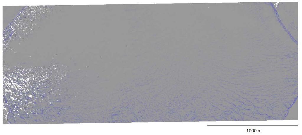
8 Taylor Glacier 500 m 1000 m

9 Taylor Glacier

10 Discussion Surface roughness is a key factor in being able to apply PIV to glaciers Example to the right Rougher surface features are relatively easily mapped but the smoother areas cannot yet be mapped with confidence This may be a result of data point density, since smaller surface features on smoother regions may not be well defined PIV velocities tend to be lower than velocities collected by both in situ and hand tracking measurements Fountain et al. (2006) found velocities ranging from m/y throughout Taylor Valley Smaller features may be identified more readily with PIV than could easily be measured manually PIV algorithm may map some small scale features that are not consistent between 2001 and 2014 Photo Credit: Darren Hauser, NCALM

11 Conclusions PIV has been shown to map glacier surface velocities reasonably clearly Attention in the use of PIV on glaciers should be paid to surface roughness The direction of surface features are also likely to play a key role Taylor Glacier terminus has far more along glacier ridges and valleys (Johnston et al., 2005) than Canada glacier, where ridge and valley features are primarily cross glacier in nature Continuing research will apply this technique to other glacier LiDAR data to better understand the effect of surface features and data resolution on PIV Image of Taylor Glacier terminus shown at right Photo Credit: Darren Hauser, NCALM
12 References Fountain, A.G., Nylen, T.H., MacClune, K.L., and Dana, G.L. (2006). Glacier mass balances ( ), Taylor Valley, McMurdo Dry Valleys, Antarctica. Journal of Glaciology, 52,178, Fountain, A.G., Levy, J.S., Gooseff, M.N., and D. Van Horn (2014). The McMurdo Dry Valleys: A landscape on the threshold of change. Geomorphology, 225, 25-35, doi: /j.geomorph Fountain, A.G., Basagic, H.J., and Niebuhr, S. (2016). Glaciers in equilibrium, McMurdo Dry Valleys, Antarctica. Journal of Glaciology, 1-14, doi: /jog Johnston, R.R., Fountain, A.G., and Nylen, T.H. (2005). The origin of channels on lower Taylor Glacier, McMurdo Dry Valleys, Antarctica, and their implication for water runoff. Annals of Glaciology, 40. Robinson, P.H. (1984). Ice dynamics and thermal regime of Taylor Glacier, South Victoria Land, Antarctica. Journal of Glaciology, 30, 105, Thielicke, W. and Stamhuis, E.J. (2014a): PIVlab Towards User-friendly, Affordable and Accurate Digital Particle Image Velocimetry in MATLAB. Journal of Open Research Software 2(1):e30, DOI: /jors.bl. Thielicke, W. and Stamhuis, E. J. (2014b): PIVlab - Time-Resolved Digital Particle Image Velocimetry Tool for MATLAB (version: X.XX modify this). DOI: /m9.figshare

13 Questions? Photo Credit: Darren Hauser, NCALM
 7 m/y for Taylor Glacier 1999-2001 Robinson (1984) 5-15 m/y 1975-1978 Kavanaugh et al.")
14 In Situ Studies Johnston et al. (2005) 7 m/y for Taylor Glacier Robinson (1984) 5-15 m/y Kavanaugh et al. (2009) 5-15 m/y Figure from Kavanaugh et al. (2009)


15 Canada Glacier


16 Taylor Glacier
UTILIZING LIDAR DATA FOR DETECTION OF CHANNEL MIGRATION TAYLOR VALLEY, ANTARCTICA ID: C34A-05
 Martin, M., Commonwealth Glacier, Dry Valleys, Digital Image, Oceanwide Expeditions UTILIZING LIDAR DATA FOR DETECTION OF CHANNEL MIGRATION TAYLOR VALLEY, ANTARCTICA ID: C34A-05 M. Camille Barlow, Jennifer
Geomorphologic Mapping by Airborne Laser Scanning in Southern Victoria Land
 Geomorphologic Mapping by Airborne Laser Scanning in Southern Victoria Land Bea Csatho, Terry Wilson, Tony Schenk, Garry McKenzie, Byrd Polar Research Center, The Ohio State University, Columbus, OH William
ANALYSIS OF GLACIER CHANGE IN THE SIERRA NEVADA PORTLAND STATE UNIVERSITY DEPARTMENT OF GEOLOGY BRADLEY BUSELLI
 ANALYSIS OF GLACIER CHANGE IN THE SIERRA NEVADA PORTLAND STATE UNIVERSITY DEPARTMENT OF GEOLOGY BRADLEY BUSELLI Study area: Sierra Nevada (Glaciers, 2015) Closer look (Glaciers, 2015) Primary goal: Research
Using High-Resolution Commercial Imagery in the Geosciences
 Using High-Resolution Commercial Imagery in the Geosciences George Roth Geospatial Support Specialist 2015 AGU Student & Early Career Scientist Conference San Francisco, CA December 13th, 2015 The Geoscience
Supplementary Fig. 1. Locations of thinning transects and photos of example samples. Mt Suess/Gondola Ridge transects extended metres above
 Supplementary Fig. 1. Locations of thinning transects and photos of example samples. Mt Suess/Gondola Ridge transects extended 260 24 metres above the modern surface of Mackay Glacier, and included 16
MCMURDO DRY VALLEYS ANTARCTICA
 POLAR WEEKEND MCMURDO DRY VALLEYS ANTARCTICA TOPIC: The McMurdo Dry Valleys, An Ecosystem of microbial life PROJECT PERSONNEL: Dr. Andrew G. Fountain, Geologist, Portland State University, Portland Oregon
Terrain Analysis of Taylor Valley, McMurdo Dry Valleys, Antarctica Logan Schmidt, University of Texas Institute for Geophysics.
 Terrain Analysis of Taylor Valley, McMurdo Dry Valleys, Antarctica Logan Schmidt, University of Texas Institute for Geophysics Abstract The surface geology of Taylor Valley records information about the
Geomorphologic Mapping by Airborne Laser Scanning in the Antarctic Dry Valleys. Bea Csatho and Tony Schenk The Ohio State University, Columbus, OH
 Geomorphologic Mapping by Airborne Laser Scanning in the Antarctic Dry Valleys Bea Csatho and Tony Schenk The Ohio State University, Columbus, OH Outline Overview of airborne laser mapping and polar applications
Digital Elevation Models. Using elevation data in raster format in a GIS
 Digital Elevation Models Using elevation data in raster format in a GIS What is a Digital Elevation Model (DEM)? Digital representation of topography Model based on scale of original data Commonly a raster
Automatic Change Detection from Remote Sensing Stereo Image for Large Surface Coal Mining Area
 doi: 10.14355/fiee.2016.05.003 Automatic Change Detection from Remote Sensing Stereo Image for Large Surface Coal Mining Area Feifei Zhao 1, Nisha Bao 2, Baoying Ye 3, Sizhuo Wang 4, Xiaocui Liu 5, Jianyan
Tatsuo Sekiguchi* and Hiroshi Sato*
 by Tatsuo Sekiguchi* and Hiroshi Sato* ABSTRACT Landslides induced by heavy rainfall and earthquakes may result in disaster by destroying homes and buildings. High-fluidity landslides caused by liquefied
GCD WORKSHOP E. TRADITIONAL APPROACHES TO GEOMORPHIC CHANGE DETECTION
 GCD WORKSHOP ICRRR Workshop Joe Wheaton THE BACKGROUND PROBLEM Rivers change through time how do we detect that change? 1 BECOMING EASIER TO TRACK CHANGE... Wheaton (2008) HOW CAN WE CALCULATE CHANGE?
THESIS APPROVAL. The abstract and thesis of Jonathan Clifford Ebnet for the Master of Science in
 THESIS APPROVAL The abstract and thesis of Jonathan Clifford Ebnet for the Master of Science in Geology were presented February 5, 2010, and accepted by the thesis committee and the department. COMMITTEE
Measuring earthquake-generated surface offsets from high-resolution digital topography
 Measuring earthquake-generated surface offsets from high-resolution digital topography July 19, 2011 David E. Haddad david.e.haddad@asu.edu Active Tectonics, Quantitative Structural Geology, and Geomorphology
Regional-scale landslide and erosion monitoring utilizing airborne LiDAR change detection analysis
 Regional-scale landslide and erosion monitoring utilizing airborne LiDAR change detection analysis October 23, 2017 Andrew Mitchell, Matt Lato, Scott McDougall, Mike Porter, Stephanie Bale, Andrew Watson
The ICESat 2 Mission Laser altimetry of ice, clouds and land elevation
 OSTM SWT San Diego October 2011 The ICESat 2 Mission Laser altimetry of ice, clouds and land elevation and also ocean, coastal, and continental waters Charon Birkett, ESSIC/UMD on behalf of T. Markus,
Use of Geophysical Software for Interpretation of Ice-Penetrating Radar Data and Mapping of Polar Ice Sheets
 Use of Geophysical Software for Interpretation of Ice-Penetrating Radar Data and Mapping of Polar Ice Sheets Alex O. Martinez University of Kansas 2335 Irving Hill Road Lawrence, KS 66045-7612 http://cresis.ku.edu
Drilling Induced Fracture (DIF) Characterization and Stress Pattern Analysis of the Southern McMurdo Sound (SMS) Core, Vitoria Land Basin, Antarctica
 Characterization and Stress Pattern Analysis of the Southern McMurdo Sound (SMS) Core, Vitoria Land Basin, Antarctica") Drilling Induced Fracture (DIF) Characterization and Stress Pattern Analysis of the Southern McMurdo Sound (SMS) Core, Vitoria Land Basin, Antarctica ABSTRACT Ezer Patlan Academic Affiliation, Fall 2008:
Drilling Induced Fracture (DIF) Characterization and Stress Pattern Analysis of the Southern McMurdo Sound (SMS) Core, Vitoria Land Basin, Antarctica ABSTRACT Ezer Patlan Academic Affiliation, Fall 2008:
Using Remote Sensing to Analyze River Geomorphology
 Using Remote Sensing to Analyze River Geomorphology Seeing Water from Space Workshop August 11 th, 2015 George Allen geoallen@unc.edu Rivers impact: Geology Ecology Humans The atmosphere River Geomorphology
Product Validation Report Polar Ocean
 Product Validation Report Polar Ocean Lars Stenseng PVR, Version 1.0 July 24, 2014 Product Validation Report - Polar Ocean Lars Stenseng National Space Institute PVR, Version 1.0, Kgs. Lyngby, July 24,
Image 1: Earth from space
 Image 1: Earth from space Credit: NASA Spacecraft: Apollo 17 Sensor: camera using visible light Image date: December 7, 1972 This image is a photograph of Earth taken by Harrison "Jack" Schmitt, an astronaut
Effect of Data Processing on Data Quality
 Journal of Computer Science 4 (12): 1051-1055, 2008 ISSN 1549-3636 2008 Science Publications Effect of Data Processing on Data Quality Al Rawashdeh Samih Department of Engineering, Department of Surveying
Brita Horlings
 Knut Christianson Brita Horlings brita2@uw.edu https://courses.washington.edu/ess431/ Natural Occurrences of Ice: Distribution and environmental factors of seasonal snow, sea ice, glaciers and permafrost
The McMurdo Dry Valleys of Antarctica: harshest place on Earth or a polar oasis?
 LIVE INTERACTIVE LEARNING @ YOUR DESKTOP The McMurdo Dry Valleys of Antarctica: harshest place on Earth or a polar oasis? Presented by: Dr. Cristina Vesbach, Dr. Michael Gooseff, and Dr. Jeb Barrett Thursday,
FROM CRYOSPHERE TO ANTHROPOGENIC IMPACTS
 FROM CRYOSPHERE Balázs Nagy Department of Physical Geography Eötvös Loránd University, Budapest TO ANTHROPOGENIC IMPACTS primary data and environmental applications: - summary of the Hungarian high altitude
Integrating LiDAR data into the workflow of cartographic representation.
 Integrating LiDAR data into the workflow of cartographic representation. Cartographic Workflow I. 1 2 3 4 5 Surveying Vector (Nat. GDB) GPS, Laser Range Finder Yes/ No Scanning old maps LiDARflights Capture
Sinéad Louise Farrell1,2,3 Thomas Newman1,2,, Alek Petty 1,2, Jackie Richter-Menge4, Dave McAdoo1,2, Larry Connor2
 Sinéad Louise Farrell1,2,3 Thomas Newman1,2,, Alek Petty 1,2, Jackie Richter-Menge4, Dave McAdoo1,2, Larry Connor2 1 Earth System Science Interdisciplinary Center, University of Maryland, USA 2 NOAA Laboratory
Hydrologic Response to Extreme Warm and Cold Summers in the McMurdo Dry Valleys, East Antarctica
 Portland State University PDXScholar Geography Faculty Publications and Presentations Geography 1-1-2008 Hydrologic Response to Extreme Warm and Cold Summers in the McMurdo Dry Valleys, East Antarctica
ESTIMATING SNOWMELT CONTRIBUTION FROM THE GANGOTRI GLACIER CATCHMENT INTO THE BHAGIRATHI RIVER, INDIA ABSTRACT INTRODUCTION
 ESTIMATING SNOWMELT CONTRIBUTION FROM THE GANGOTRI GLACIER CATCHMENT INTO THE BHAGIRATHI RIVER, INDIA Rodney M. Chai 1, Leigh A. Stearns 2, C. J. van der Veen 1 ABSTRACT The Bhagirathi River emerges from
Spatial and Temporal Variability of Glacier Melt in the McMurdo Dry Valleys, Antarctica
 Portland State University PDXScholar Dissertations and Theses Dissertations and Theses 1-1-211 Spatial and Temporal Variability of Glacier Melt in the McMurdo Dry Valleys, Antarctica Matthew James Hoffman
11. ALPINE GLACIAL LANDFORMS
 Geomorphology 11. Alpine Glacial Landforms 11. ALPINE GLACIAL LANDFORMS 40 Points One objective of this exercise is for you be able to identify alpine glacial landforms and measure their characteristics.
Evaluating the Discrete Element Method as a Tool for Predicting the Seasonal Evolution of the MIZ
 DISTRIBUTION STATEMENT A. Approved for public release; distribution is unlimited. Evaluating the Discrete Element Method as a Tool for Predicting the Seasonal Evolution of the MIZ Arnold J. Song Cold Regions
Menno W. Straatsma, Hans Middelkoop, Steven de Jong
 Fig. A-2.1: Field photograph of a floodplain with a side channel. After deposition, sediment-associated pollutants, such as metals, are incorporated in the ecological food-chain (Torres and Johnson, 2001).
RADAR Remote Sensing Application Examples
 RADAR Remote Sensing Application Examples! All-weather capability: Microwave penetrates clouds! Construction of short-interval time series through cloud cover - crop-growth cycle! Roughness - Land cover,
Biogeochemical Evolution of Cryoconite Holes on Canada Glacier, Taylor Valley, Antarctica
 Portland State University PDXScholar Geography Faculty Publications and Presentations Geography 12-21-2007 Biogeochemical Evolution of Cryoconite Holes on Canada Glacier, Taylor Valley, Antarctica Elizabeth
Ice dynamics from Earth observations
 Ice dynamics from Earth observations Twila Moon Bristol Glaciology Centre Geographical Sciences University of Bristol twila.moon@bristol.ac.uk www.twilamoon.com 1 When you have mapped the ice sheets once
Digital Elevation Models (DEM)
") Digital Elevation Models (DEM) Digital representation of the terrain surface enable 2.5 / 3D views Rule #1: they are models, not reality Rule #2: they always include some errors (subject to scale and data
Digital Elevation Models (DEM) Digital representation of the terrain surface enable 2.5 / 3D views Rule #1: they are models, not reality Rule #2: they always include some errors (subject to scale and data
An Arctic Perspective on Climate Change
 An Arctic Perspective on Climate Change 23 Oct 2012 Gifford Miller (and many others) University of Colorado Boulder The Earth is warming How do we know? Temperature Anomaly ( C) It s a fact Global Land
Pierce Cedar Creek Institute GIS Development Final Report. Grand Valley State University
 Pierce Cedar Creek Institute GIS Development Final Report Grand Valley State University Major Goals of Project The two primary goals of the project were to provide Matt VanPortfliet, GVSU student, the
Developing Spatial Awareness :-
 Developing Spatial Awareness :- We begin to exercise our geographic skill by examining he types of objects and features we encounter. Four different spatial objects in the real world: Point, Line, Areas
Hydrologic response to extreme warm and cold summers in the McMurdo Dry Valleys, East Antarctica
 Antarctic Science page 1 of 11 (2008) & Antarctic Science Ltd 2008 doi: 10.1017/S0954102008001272 1 2 3 4 5 6 7 8 9 10 11 12 13 14 15 16 17 18 19 20 21 22 23 24 25 26 27 28 29 30 31 32 33 34 35 36 37 38
Airborne Remote Sensing for Ocean and Coastal Applications
 Airborne Remote Sensing for Ocean and Coastal Applications Ben Reineman, Luc Lenain, Nick Statom, David Castel, Ken Melville Scripps Institution of Oceanography 17 October, 2011 Address for correspondence:
SLOPE HAZARD AND RISK MAPPING: A TECHNOLOGICAL PERSPECTIVE
 International Symposium on Multi-Hazard and Risk 2015 23-24 March 2015, UTM Kuala Lumpur SLOPE HAZARD AND RISK MAPPING: A TECHNOLOGICAL PERSPECTIVE Very high resolution DTM derived from LiDAR LiDAR Ortho
Frank Hegyi President, Ferihill Technologies Ltd Victoria, B.C.
 REMOTE SENSING TECHNIQUES IN ENVIRONMENTAL MONITORING By Frank Hegyi President, Ferihill Technologies Ltd Victoria, B.C. ABSTRACT Increasing public awareness about environmental concerns is creating pressures
Ice Observations on the Churchill River using Satellite Imagery
 CGU HS Committee on River Ice Processes and the Environment 15 th Workshop on River Ice St. John s, Newfoundland and Labrador, June 15-17, 2009 Ice Observations on the Churchill River using Satellite Imagery
Watershed Delineation in GIS Environment Rasheed Saleem Abed Lecturer, Remote Sensing Centre, University of Mosul, Iraq
 Watershed Delineation in GIS Environment Rasheed Saleem Abed Lecturer, Remote Sensing Centre, University of Mosul, Iraq Abstract: The management and protection of watershed areas is a major issue for human
Summary Visualizations for Coastal Spatial Temporal Dynamics
 Summary Visualizations for Coastal Spatial Temporal Dynamics October 24 2011 Providence, RI Sidharth Thakur 1, Laura Tateosian 2, Helena Mitasova, Eric Hardin, and Margery Overton 1. sthakur@renci.org,
Welcome to PolarConnect. With Kelly McCarthy and NASA s Operation IceBridge
 Welcome to PolarConnect With Kelly McCarthy and NASA s Operation IceBridge 5 May 2016 If you are joining by phone, please mute your phone. Press *6 to mute and *6 to unmute. Participant Introductions In
Down-stream process transition (f (q s ) = 1)
 = 1)") Down-stream process transition (f (q s ) = 1) Detachment Limited S d >> S t Transport Limited Channel Gradient (m/m) 10-1 Stochastic Variation { Detachment Limited Equilibrium Slope S d = k sd A -θ d S
Down-stream process transition (f (q s ) = 1) Detachment Limited S d >> S t Transport Limited Channel Gradient (m/m) 10-1 Stochastic Variation { Detachment Limited Equilibrium Slope S d = k sd A -θ d S
Modeling Coastal Change Using GIS Technology
 Emily Scott NRS 509 Final Report December 5, 2013 Modeling Coastal Change Using GIS Technology In the past few decades, coastal communities around the world are being threatened by accelerating rates of
Near-surface internal melting: a substantial mass loss on Antarctic Dry Valley glaciers
 Journal of Glaciology, Vol. 60, No. 220, 2014 doi: 10.3189/2014JoG13J095 361 Near-surface internal melting: a substantial mass loss on Antarctic Dry Valley glaciers Matthew J. HOFFMAN, 1* Andrew G. FOUNTAIN,
Waterborne Environmental, Inc., Leesburg, VA, USA 2. Syngenta Crop Protection, LLC, North America 3. Syngenta Crop Protection, Int.
 Application of High Resolution Elevation Data (LiDAR) to Assess Natural and Anthropogenic Agricultural Features Affecting the Transport of Pesticides at Multiple Spatial Scales Josh Amos 1, Chris Holmes
Exam II: Water, Winds, Deserts, Oceans
 Montclair State University, College of Science and Mathematics Department of Earth and Environmental Studies EAES101 Planet Earth Semester: SAMPLE Dr. Mark Chopping Exam II: Water, Winds, Deserts, Oceans
Glacier Elevation, Volume and Mass Change
 8/8/12 Glacier Elevation, Volume and Mass Change 1 Outline: Elevation, Volume and Mass Change ① Elevation change fundamentals ② Elevation measurement platforms ③ Calculating elevation change ④ Calculating
DEM-based Ecological Rainfall-Runoff Modelling in. Mountainous Area of Hong Kong
 DEM-based Ecological Rainfall-Runoff Modelling in Mountainous Area of Hong Kong Qiming Zhou 1,2, Junyi Huang 1* 1 Department of Geography and Centre for Geo-computation Studies, Hong Kong Baptist University,
THESIS APPROVAL. The abstract and thesis of Amy Francis Ebnet for the Master of Science in Geology. COMMITTEE APPROVALS: Andrew G.
 THESIS APPROVAL The abstract and thesis of Amy Francis Ebnet for the Master of Science in Geology were presented October 3, 5, and accepted by the thesis committee and the department. COMMITTEE APPROVALS:
ENVS S102 Earth and Environment (Cross-listed as GEOG 102) ENVS S110 Introduction to ArcGIS (Cross-listed as GEOG 110)
 ENVS S110 Introduction to ArcGIS (Cross-listed as GEOG 110)") ENVS S102 Earth and Environment (Cross-listed as GEOG 102) 1. Describe the fundamental workings of the atmospheric, hydrospheric, lithospheric, and oceanic systems of Earth 2. Explain the interactions
ENVS S102 Earth and Environment (Cross-listed as GEOG 102) 1. Describe the fundamental workings of the atmospheric, hydrospheric, lithospheric, and oceanic systems of Earth 2. Explain the interactions
Remote Sensing I: Basics
 Remote Sensing I: Basics Kelly M. Brunt Earth System Science Interdisciplinary Center, University of Maryland Cryospheric Science Laboratory, Goddard Space Flight Center kelly.m.brunt@nasa.gov (Based on
A Stable Isotopic Investigation of a Polar Desert Hydrologic System, McMurdo Dry Valleys, Antarctica
 Arctic, Antarctic, and Alpine Research, Vol. 38, No. 1, 2006, pp. 60 71 A Stable Isotopic Investigation of a Polar Desert Hydrologic System, McMurdo Dry Valleys, Antarctica Michael N. Gooseff * W. Berry
Vermont Stream Geomorphic Assessment. Appendix E. River Corridor Delineation Process. VT Agency of Natural Resources. April, E0 - April, 2004
 Vermont Stream Geomorphic Assessment Appendix E River Corridor Delineation Process Vermont Agency of Natural Resources - E0 - River Corridor Delineation Process Purpose A stream and river corridor delineation
K&C Phase 4 Status report. Ice Sheet Monitoring using ALOS-2. University of California, Irvine 2 JPL
 K&C Phase 4 Status report Ice Sheet Monitoring using ALOS-2 Bernd Scheuchl 1, Jeremie Mouginot 1, Eric Rignot 1,2 1 University of California, Irvine 2 JPL Science Team meeting #24 Tokyo, Japan, January
Digital Elevation Models (DEM) / DTM
 / DTM") Digital Elevation Models (DEM) / DTM Uses in remote sensing: queries and analysis, 3D visualisation, classification input Fogo Island, Cape Verde Republic ASTER DEM / image Banks Peninsula, Christchurch,
Digital Elevation Models (DEM) / DTM Uses in remote sensing: queries and analysis, 3D visualisation, classification input Fogo Island, Cape Verde Republic ASTER DEM / image Banks Peninsula, Christchurch,
Estimation of Forecat uncertainty with graphical products. Karyne Viard, Christian Viel, François Vinit, Jacques Richon, Nicole Girardot
 Estimation of Forecat uncertainty with graphical products Karyne Viard, Christian Viel, François Vinit, Jacques Richon, Nicole Girardot Using ECMWF Forecasts 8-10 june 2015 Outline Introduction Basic graphical
Virtual Sensors and Large-Scale Gaussian Processes
 Virtual Sensors and Large-Scale Gaussian Processes Ashok N. Srivastava, Ph.D. Principal Investigator, IVHM Project Group Lead, Intelligent Data Understanding ashok.n.srivastava@nasa.gov Coauthors: Kamalika
TEMPORAL VARIABILITY OF ICE FLOW ON HOFSJÖKULL, ICELAND, OBSERVED BY ERS SAR INTERFEROMETRY
 TEMPORAL VARIABILITY OF ICE FLOW ON HOFSJÖKULL, ICELAND, OBSERVED BY ERS SAR INTERFEROMETRY Florian Müller (1), Helmut Rott (2) (1) ENVEO IT, Environmental Earth Observation GmbH, Technikerstrasse 21a,
Spatial modelling of wetness for the Antarctic Dry Valleys
 RESEARCH/REVIEW ARTICLE Spatial modelling of wetness for the Antarctic Dry Valleys Glen Stichbury 1, Lars Brabyn 1, T.G. Allan Green 2 & Craig Cary 2 1 Department of Geography, Tourism and Environmental
Arctic Climate Connections Activity 3 Exploring Arctic Climate Data
 Arctic Climate Connections Activity 3 Exploring Arctic Climate Data Part A. Understanding Albedo Albedo is the ratio of incoming solar radiation that is reflected back into space. Albedo is expressed as
SNOW DYNAMICS IN A POLAR DESERT, MCMURDO DRY VALLEYS, ANTARCTICA
 The Pennsylvania State University The Graduate School College of Engineering SNOW DYNAMICS IN A POLAR DESERT, MCMURDO DRY VALLEYS, ANTARCTICA A Thesis in Civil Engineering by Jeffery W. Eveland 2012 Jeffery
Applications of GIS in assessing Coastal Change Rachel Hehre November 30, 2004 NRS 509 OVERVIEW
 Applications of GIS in assessing Coastal Change Rachel Hehre November 30, 2004 NRS 509 OVERVIEW ITRODUCTION Due to the dynamic nature of coastal systems, representing coastal change with precision and
Abstracts - Technical Presentations 1 st Joint LiDAR Workshop 29 June 2016
 Abstracts - Technical Presentations 1 st Joint LiDAR Workshop 29 June 2016 10:30 AM Title: The Finer details: Processing algorithm adjustment and point cloud/survey data statistics in wetlands. Authors:
Characterization of the Nigerian Shoreline using Publicly-Available Satellite Imagery
 University of New Hampshire University of New Hampshire Scholars' Repository Center for Coastal and Ocean Mapping Center for Coastal and Ocean Mapping 1-2014 Characterization of the Nigerian Shoreline
An Internet-based Agricultural Land Use Trends Visualization System (AgLuT)
") An Internet-based Agricultural Land Use Trends Visualization System (AgLuT) Prepared for Missouri Department of Natural Resources Missouri Department of Conservation 07-01-2000-12-31-2001 Submitted by
An Internet-based Agricultural Land Use Trends Visualization System (AgLuT) Prepared for Missouri Department of Natural Resources Missouri Department of Conservation 07-01-2000-12-31-2001 Submitted by
Australian Soil and Land Survey Field Handbook THIRD EDITION THE NATIONAL COMMITTEE ON SOIL AND TERRAIN
 Australian Soil and Land Survey Field Handbook THIRD EDITION THE NATIONAL COMMITTEE ON SOIL AND TERRAIN CSIRO 2009 All rights reserved. Except under the conditions described in the Australian Copyright
Thomas P. Phillips CIRES Prof K. Steffen, L. Colgan PhD ABD, D. McGrath MA
 Thomas P. Phillips CIRES Prof K. Steffen, L. Colgan PhD ABD, D. McGrath MA Problem: we know very little about the processes happening within the Greenland Ice Sheet. What is the velocity at the base? What
1.2: Observing the Surfaces of Mars and Earth
 GEOLOGY ON MARS Unit 1 - Chapter 1-2 Comparing Rocky Planets 1.2: Observing the Surfaces of Mars and Earth Log on to Amplify Geology on Mars Chapter 1.2 In a moment, you will watch a video made by other
Areal Scour vs. Selective Linear Erosion
 Erosional Forms and Landscapes Erosional Landscapes Areal Scour vs. Selective Linear Erosion Cirques Form and Morphology Many Forms Red Tarn Cirque Basin English Lake District Red Tarn Cirque Basin, English
Reflecting on Toolik: Recent advances for understanding Arctic ecology using lidar data
 Reflecting on Toolik: Recent advances for understanding Arctic ecology using lidar data TEAM LASER ALASKA Lee Vierling Students: Heather Greaves, Troy Magney, Jess Gersony, Case Prager Co-PI s: Natalie
Summer School in Glaciology, Fairbanks/McCarthy, Exercises: Glacial geology
 Bob Anderson Summer School in Glaciology, Fairbanks/McCarthy, 2010 Exercises: Glacial geology 1. Glacier thickness. We wish to estimate the local thickness of a glacier given only a topographic map of
Glacial Modification of Terrain
 Glacial Modification Part I Stupendous glaciers and crystal snowflakes -- every form of animate or inanimate existence leaves its impress upon the soul of man. 1 -Orison Swett Marden Glacial Modification
How to Construct Urban Three Dimensional GIS Model based on ArcView 3D Analysis
 How to Construct Urban Three Dimensional GIS Model based on ArcView 3D Analysis Ko Ko Lwin Division of Spatial Information Science Graduate School of Life and Environmental Sciences University of Tsukuba
Graduate Courses Meteorology / Atmospheric Science UNC Charlotte
 Graduate Courses Meteorology / Atmospheric Science UNC Charlotte In order to inform prospective M.S. Earth Science students as to what graduate-level courses are offered across the broad disciplines of
Resolving habitat classification and structure using aerial photography. Michael Wilson Center for Conservation Biology College of William and Mary
 Resolving habitat classification and structure using aerial photography Michael Wilson Center for Conservation Biology College of William and Mary Aerial Photo-interpretation Digitizing features of aerial
General Overview and Facts about the Irobland
 Using Geoinformation Science to Reveal the Impact of the Eritrea-Ethiopia Boundary Commission s Decision on Irobland and People By Alema Tesfaye, Washington DC, USA Part I General Overview and Facts about
Breakout Session III Evolving landscapes and global environmental change
 Breakout Session III Evolving landscapes and global environmental change 1. Hydrology and critical zone imaging 2. Glaciology: Instrumenting glaciers and ice sheets 3. Polar networks and glacial isostatic
Rapid Mass Movement Simulation RAMMS
 R Rapid Mass Movement Simulation RAMMS Yves Bühler, Marc Christen, Perry Bartelt, SLF Christoph Graf & Brian McArdell, WSL WSL Institute for Snow and Avalanche Research SLF Switzerland: long tradition
What is a Glacier? Types of Glaciers
 Alpine & Continental Glaciers Glacial Mass Balance Glacial Ice Formation Glacial Movement & Erosion Erosional and Depositional Landforms The Pleistocene Epoch Geomorphology of SW Manitoba Chapter 17 1
Determining the Impact of Sea Ice Thickness on the
 US NAVAL RESEARCH LABORATORY FIVE YEAR RESEARCH OPTION Determining the Impact of Sea Ice Thickness on the Arctic s Naturally Changing Environment (DISTANCE) Co-PI s for NRL John Brozena, Joan Gardner (Marine
Notes for Remote Sensing: Glacier Elevation, Volume and Mass Change
 Notes for Remote Sensing: Glacier Elevation, Volume and Mass Change Elevation and Volume Change: Alex S Gardner Atmospheric Oceanic and Space Sciences, University of Michigan Aircraft- and satellite- mounted
ENGRG Introduction to GIS
 ENGRG 59910 Introduction to GIS Michael Piasecki March 17, 2014 Lecture 08: Terrain Analysis Outline: Terrain Analysis Earth Surface Representation Contour TIN Mass Points Digital Elevation Models Slope
Object Based Imagery Exploration with. Outline
 Object Based Imagery Exploration with Dan Craver Portland State University June 11, 2007 Outline Overview Getting Started Processing and Derivatives Object-oriented classification Literature review Demo
PROFILING OF MAJOR RIVER SYSTEMS AROUND MAYON VOLCANO USING AIRSAR IMAGES
 PROFILING OF MAJOR RIVER SYSTEMS AROUND MAYON VOLCANO USING AIRSAR IMAGES Rowena B. QUIAMBAO, Ronnie C. Torres Philippine Institute of Volcanology & Seismology C.P. Garcia Street, University of the Philippines
1 st Newsletter. IPA Task Force on Remote Sensing of Permafrost
 1 st Newsletter IPA Task Force on Remote Sensing of Permafrost Co Chairs: Guido Grosse (UAF; ffgg1@uaf.edu) & Claude Duguay (University of Waterloo; crduguay@uwaterloo.ca) http://www.permafrostwatch.org/news/ipa_taskforce_remotesensing.html
Seasonal controls on snow distribution and aerial ablation at the snow-patch and landscape scales, McMurdo Dry Valleys, Antarctica
 ess doi:10.5194/tc-7-917-2013 Author(s) 2013. CC Attribution 3.0 License. The Cryosphere Open Access Seasonal controls on snow distribution and aerial ablation at the snow-patch and landscape scales, McMurdo
Lecture 19: Operational Remote Sensing in Visible, IR, and Microwave Channels
 MET 4994 Remote Sensing: Radar and Satellite Meteorology MET 5994 Remote Sensing in Meteorology Lecture 19: Operational Remote Sensing in Visible, IR, and Microwave Channels Before you use data from any
Supplementary Figure 1. Images from sampling locations. a) and b): Field observations of meltwater ponds, Tear Drop Lake and Boulder Lake,
 and b): Field observations of meltwater ponds, Tear Drop Lake and Boulder Lake,") Supplementary Figure 1. Images from sampling locations. a) and b): Field observations of meltwater ponds, Tear Drop Lake and Boulder Lake, respectively. The ponds are situated at the depressions of the
Supplementary Figure 1. Images from sampling locations. a) and b): Field observations of meltwater ponds, Tear Drop Lake and Boulder Lake, respectively. The ponds are situated at the depressions of the
Cliff collapse monitoring with InSAR
 Gosia Mider PhD Researcher Supervisors: Dr. James Lawrence, Dr. Richard Ghail 12 th December 2018 AGENDA Introduction and motivation Recent collapses in chalk Methodology Results Summary and conclusions
Prentice Hall EARTH SCIENCE
 Prentice Hall EARTH SCIENCE Tarbuck Lutgens Chapter 7 Glaciers, Desert, and Wind 7.1 Glaciers Types of Glaciers A glacier is a thick ice mass that forms above the snowline over hundreds or thousands of
08/01/2012. LiDAR. LiDAR Benefits. LiDAR-BASED DELINEATION OF WETLAND BORDERS. CCFFR-2012 Society for Canadian Limnologists:
 LiDAR CCFFR-2012 Society for Canadian Limnologists: Science for Wetland Policy and Management LiDAR-BASED DELINEATION OF WETLAND BORDERS Distance from laser to ground and back again: Determined as laser-pulse
GIS feature extraction tools in diverse landscapes
 CE 394K.3 GIS in Water Resources GIS feature extraction tools in diverse landscapes Final Project Anna G. Kladzyk M.S. Candidate, Expected 2015 Department of Environmental and Water Resources Engineering
Publications. In Press
 Publications. In Press Levy, J.S., Fountain, A.G., O Connor, J.E., Welch, K.A., and Lyons, W.B., Garwood Valley, Antarctica: A new record of last glacial maximum to Holocene glacio-fluvial processes from