HYDRAULIC SIMULATION OF THE THIELLE
|
|
|
- Brooke Robertson
- 5 years ago
- Views:
Transcription


1 HYDRAULIC SIMULATION OF THE THIELLE EXTREME FLOOD EVENT AND CONSEQUENCES OF FAILURE DIKE Quentin Theiler sd ingénierie dénériaz et pralong sion sa


2 Location of the project

3 Current situation
4 The project Hazard formed by different processes: Flood events by overflow (insufficient capacity of the river, return period 30 years) Exfiltration trough the dike Upwelling of the water table This area: high biological interest The project: Revitalization of the river with ecological objectives Protection against flood events with a return period of 100 years Widening of the river along a section Construction of three weirs
5 Aim of the modelisation Verify the geometry of the modelisation for Q100 (made initially on HecRas) with Basement Study the position, length and efficiency of the three weirs Analyze the upstream part for extreme events without and with a scenario of breaking dike
6 Methodology 1. Data pre-processing Hec Ras (export of the cross section of the project) Excel (treatment of the cross section, definition of the top of the dike) ArcInfo (creation od the DEM with interpolation of the cross section) SMS Aquaveo (generation of the grid, material property, bouddary nodes) 2. Simulation Basement 3. Data post-processing Octave (export of the maximum depth and maximum intenstiy of all time steps) SMS et Arcinfo (import maximum value, generation of the coutours, creation of the new intensity map)


7 HecRas Excel ArcInfo ArcInfo Lake ArcInfo


8 ArcInfo SMS elements m² Mean Resolution: 19m² SMS


9 Final mesh of the project Outflow Inflow
 scenario 1a scenario 1b Inflow: hydrograph Outflow: zhydrograph (flood occurring in the lake) flow m 3 /s Inflow Sum of")
10 Simulation with Basement (flood occurring in the lake) Stationary case for Q100 = 200 m³/s (scenario 1a) Extreme flood Qextrem = 300 m³/s with three weirs on service (scenario 1b) Extreme event upstream of the revitalization, without and with dike breaking (scenario 2) scenario 1a scenario 1b Inflow: hydrograph Outflow: zhydrograph (flood occurring in the lake) flow m 3 /s Inflow Sum of outflows Outflow (lake) time hour


11 Scenario 1a: stationary case, t=6 hours weir weir weir Water depth [m] The sizing of the dike s level is well defined for a stationnary flood of Q


12 Sizing of the vertical wall Q m (freeboard) Enlargement 2D model: well calibrated for Q100 Consistent with Hec Ras model, sizing of the dikes well defined


13 Scenario 1b:maximum flood, Qextreme, t=14 hours
14 Weir with freeboard of min 30cm on Q100 (wse of Hec Ras) freeboard of 42cm on Qextreme 46 cm Q100 Qextreme Horizontal axis of the cross section [m] freeboard of 77cm on Q100 freeboard of 1.34 m on Qextreme Altitude [m] Altitude [m] Horizontal axis of the cross section [m]


15 weirs Begining of the overflow: t= 9 hours, Qinflow: 260 m 3 /s The weirs will be reinforced with nonerodible coating

16 Scenario 2: extreme flood upstream of the revitalization Inflow: hydrograph project of revitalization Outflow: zero_gradient
17 Scenario 2: three possibilities Aim: protection of the aerodrome Three possibilities P1: raise the dike locally P2: construct a dike to protect the aerodrome P3: raise the road to avoid the connection between the upstream and downstream compartment

18 Increased height 1. Raise the dike locally Km to km 6.489: 2 048m Increased height of the dike 30 cm Km to km 6.237: 200m Increased height of the dike 15 cm Increased height Increased height
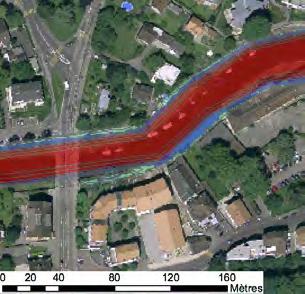
 25.01.")
19 2. Construct a dike to protect the aerodrome 55m mean extra height 110cm (with a freeboard of 25cm on the water surface elevation / low speed)
 25.01.")
20 3. raise the road to avoid the connection between the upstream and downstream compartment 170m mean extra height 50 cm (with a freeboard of 25cm on the water surface elevation / low speed)


21 P3: results of the simulation for Qext Raised road
22 Failure mechanisms for dike Overflow and overtopping Inner erosion Headcut erosion Piping Loss of slope stability Structure failure


23 Failure mechanisms for dike Weak point is known field surveys have permitted to define the places where a failure mechanism may be possible Geotechnical quality is not known (or bad everywhere) the breach will be formed at the overtopping place Rhône breach at Chamoson Breach at Meiringen
24 Breach length (cf. Rhône and Rhin) 1.5 x width of the river (minor river bed length). Beginning of the breach: time when the dikes are overflowing and overtopping and/or when destabilizing geotechnical processes happen. Speed of erosion of the dike: we admit that the breach is completely open 1 hour after the beginning of the erosion. In reality, it s possible that this phenomenon is quicker or slower. We admit an aperture of ¼ during 30 minutes followed of an aperture of ½ during 30 minutes and finally a complete aperture. The elevation of the weir after the breach is defined according to the cross section of the dike according to an erosion slope of 0-3%
 with")

25 Breach length = 1.5 x minor river bed length = 1.5*22 35 m 3 identical mesh (same nodes) with different elevation t0 = beginning of the overtopping t1 = t minutes breach t1 = t minutes
 18m (t0 + 30 min) 35m (t0 + 60 min) Breach")
26 Simulation with breach Hydrograph: Qext = 300m³/s Level of the raised road: Beginning of the overflow: 200 m³/s Breach: 9m (t0) 18m (t min) 35m (t min) Breach Raised road


27 Actual hazard map of the Thielle Conclusion Future hazard map of the Thielle after the project In the perimeter of the project: - Q100 (sizing outflow) - Q300 - Qextreme Upstream of the project : - No raised road - Q100 - Q300 - Qextreme without breach
INFLOW DESIGN FLOOD CONTROL SYSTEM PLAN 40 C.F.R. PART PLANT YATES ASH POND 2 (AP-2) GEORGIA POWER COMPANY
 GEORGIA POWER COMPANY") INFLOW DESIGN FLOOD CONTROL SYSTEM PLAN 40 C.F.R. PART 257.82 PLANT YATES ASH POND 2 (AP-2) GEORGIA POWER COMPANY EPA s Disposal of Coal Combustion Residuals from Electric Utilities Final Rule (40 C.F.R.
INFLOW DESIGN FLOOD CONTROL SYSTEM PLAN 40 C.F.R. PART 257.82 PLANT YATES ASH POND 2 (AP-2) GEORGIA POWER COMPANY EPA s Disposal of Coal Combustion Residuals from Electric Utilities Final Rule (40 C.F.R.
Karamea floodplain investigation
 Karamea floodplain investigation NIWA Client Report: CHC2010-107 October 2010 NIWA Project: ELF 10234/1 Karamea floodplain investigation Graeme Smart Jo Bind NIWA contact/corresponding author Graeme Smart
Pompton Lakes Dam Downstream Effects of the Floodgate Facility. Joseph Ruggeri Brian Cahill Michael Mak Andy Bonner
 Pompton Lakes Dam Downstream Effects of the Joseph Ruggeri Brian Cahill Michael Mak Andy Bonner ASFPM 2013: Overview Page 2 Overview Page 3 Overview Page 4 Overview Page 5 Overview - Historical Pompton
Appendix 15 Computational Methodology
 Appendix 15 Computational Methodology Introduction This Appendix describes the process used by the risk team to determine the final loss exceedence values in the risk analysis. The process involved the
State of the Art Two- Dimensional Hydraulic Modeling Tools Model Benchmark Testing
 State of the Art Two- Dimensional Hydraulic Modeling Tools Model Benchmark Testing September 2015 Presented by: Murari Paudel, Cody Milligan, Soledad Roman, Phillip Ryan Presentation Overview Study Purpose
Technical Memorandum No
 Pajaro River Watershed Study in association with Technical Memorandum No. 1.2.10 Task: Evaluation of Four Watershed Conditions - Sediment To: PRWFPA Staff Working Group Prepared by: Gregory Morris and
WP2.1 BREACH FORMATION LARGE SCALE EMBANKMENT FAILURE
 WP2. BREACH FORMATION LARGE SCALE EMBANKMENT FAILURE Kjetil Arne Vaskinn, Sweco Gröner Norway Aslak Løvoll, Norconsult AS Norway Kaare Höeg, Norwegian Geotechnical Institute (NGI), Norway WP2. BREACH FORMATION
Better estimation of Flood Wave Propagation Time in Meandering Reaches by using 2D-modelling
 Better estimation of Flood Wave Propagation Time in Meandering Reaches by using 2D-modelling J. Persson M. Jewert N. Isaksson Norconsult AB, Sweden Norconsult AB, Sweden Fortum Generation AB, Sweden ABSTRACT
Probabilistic Evaluation of a Meandering Low-Flow Channel. February 24 th, UMSRS
 Probabilistic Evaluation of a Meandering Low-Flow Channel February 24 th, 2014 2014 UMSRS 1 2 acknowledgments Low- Flow Channel (LFC) overview Proposed Diversion Channel collects runoff from: The Rush
Degradation Concerns related to Bridge Structures in Alberta
 Degradation Concerns related to Bridge Structures in Alberta Introduction There has been recent discussion regarding the identification and assessment of stream degradation in terms of how it relates to
9. Flood Routing. chapter Two
 9. Flood Routing Flow routing is a mathematical procedure for predicting the changing magnitude, speed, and shape of a flood wave as a function of time at one or more points along a watercourse (waterway
Dam Break Analysis Using HEC-RAS and HEC-GeoRAS A Case Study of Ajwa Reservoir
 Journal of Water Resources and Ocean Science 2016; 5(6): 108-113 http://www.sciencepublishinggroup.com/j/wros doi: 10.11648/j.wros.20160506.15 ISSN: 2328-7969 (Print); ISSN: 2328-7993 (Online) Case Report
Modeling Great Britain s Flood Defenses. Flood Defense in Great Britain. By Dr. Yizhong Qu
 Modeling Great Britain s Flood Defenses AIRCurrents Editor s note: AIR launched its Inland Flood Model for Great Britain in December 2008. The hazard module captures the physical processes of rainfall-runoff
CFD Modeling for Structure Designs in Environmental Impacts Mitigation
 CFD Modeling for Structure Designs in Environmental Impacts Mitigation June 05 Navid Nekouee, Hugo Rodriguez and Steven Davie Environmental Impact Mitigation Design Savannah Harbor Expansion Project (SHEP)
FLOOD HAZARD AND RISK ASSESSMENT IN MID- EASTERN PART OF DHAKA, BANGLADESH
 FLOOD HAZARD AND RISK ASSESSMENT IN MID- EASTERN PART OF DHAKA, BANGLADESH Muhammad MASOOD MEE07180 Supervisor: Prof. Kuniyoshi TAKEUCHI ABSTRACT An inundation simulation has been done for the mid-eastern
SUPPLEMENTAL LEVEE FAILURE ANALYSIS USING NWS BREACH AND HEC-RAS EXISTING RD 799 LEVEE AT SANDMOUND SLOUGH
 SUPPLEMENTAL LEVEE FAILURE ANALYSIS USING NWS BREACH AND HEC-RAS EXISTING RD 799 LEVEE AT SANDMOUND SLOUGH FOR THE CYPRESS LAKES PROJECT CONTRA COSTA COUNTY, CALIFORNIA September 2, 2003 Prepared By: CIVIL
STRUCTURAL STABILITY ASSESSMENT
 STRUCTURAL STABILITY ASSESSMENT CFR 257.73(d) Bottom Ash Pond Complex Cardinal Plant Brilliant, Ohio October, 2016 Prepared for: Cardinal Operating Company Cardinal Plant Brilliant, Ohio Prepared by: Geotechnical
Advanced /Surface Hydrology Dr. Jagadish Torlapati Fall 2017 MODULE 2 - ROUTING METHODS
 Routing MODULE - ROUTING METHODS Routing is the process of find the distribution of flow rate and depth in space and time along a river or storm sewer. Routing is also called Flow routing or flood routing.
LAR BPWG. DWR Erosion Screening Process Application to LAR. May 17, water resource specialists
 LAR BPWG DWR Erosion Screening Process Application to LAR May 17, 2016 Presentation Outline Review of Erosion Screening Process Modifications for LAR Application ESP LAR Results Recommendations ESP Background
Leveraging new models and data to improve flood stage forecast. Improving Flood Stage Forecasting in the Feather River Watershed. September 11 th 2015
 Leveraging new models and data to improve flood stage forecast Improving Flood Stage Forecasting in the Feather River Watershed September 11 th 2015 Mitch Russo, P.E. (DWR) Ashok Bathulla, P.E., CFM (GEI)
Numerical Hydraulics
 ETH Zurich, Fall 2017 Numerical Hydraulics Assignment 2 Numerical solution of shallow water wave propagation (www.surfertoday.com) 1 Introduction 1.1 Equations Understanding the propagation of shallow
WEST CATARACT CREEK DAM FINAL DESIGN REPORT
 DAMsel In Distress Engineering 2112 S Huffer Ln Flagstaff, AZ 86011 (520) 981-9515 WEST CATARACT CREEK DAM FINAL DESIGN REPORT Prepared for: Dr. Charles Schlinger Mr. Mark Lamer TABLE OF CONTENTS Contents
Chapter 4 Hydrodynamic Modelling of Glacial Lake Outburst Floods
 Chapter 4 Hydrodynamic Modelling of Glacial Lake Outburst Floods To better understand the impacts that a GLOF can have on the downstream valleys, an attempt was made to simulate one GLOF event each in
Technical Memorandum No Sediment Model
 Pajaro River Watershed Study in association with Technical Memorandum No. 1.2.9 Sediment Model Task: Development of Sediment Model To: PRWFPA Staff Working Group Prepared by: Gregory Morris and Elsie Parrilla
APPLICATION OF HEC-RAS MODEL FOR ESTIMATING CHANGES IN WATERCOURSE GEOMETRY DURING FLOODS
 Studia Geotechnica et Mechanica, Vol. XXXIV, No. 2, 2012 DOI: 105277/sgm021206 APPLICATION OF HEC-RAS MODEL FOR ESTIMATING CHANGES IN WATERCOURSE GEOMETRY DURING FLOODS JOANNA MARKOWSKA Department of Environmental
Floodplain Modeling and Mapping Using The Geographical Information Systems (GIS) and Hec-RAS/Hec-GeoRAS Applications. Case of Edirne, Turkey.
 and Hec-RAS/Hec-GeoRAS Applications. Case of Edirne, Turkey.") Floodplain Modeling and Mapping Using The Geographical Information Systems (GIS) and Hec-RAS/Hec-GeoRAS Applications. Case of Edirne, Turkey. Fuad Hajibayov *1, Basak Demires Ozkul 1, Fatih Terzi 1 1 Istanbul
Floodplain Modeling and Mapping Using The Geographical Information Systems (GIS) and Hec-RAS/Hec-GeoRAS Applications. Case of Edirne, Turkey. Fuad Hajibayov *1, Basak Demires Ozkul 1, Fatih Terzi 1 1 Istanbul
Sediment Transport Analysis for Stream Restoration Design: The Good, the Bad, and the Ugly.
 Sediment Transport Analysis for Stream Restoration Design: The Good, the Bad, and the Ugly. Brett Jordan Phd, PE HydroGeo Designs LLC. Land and Water Services Inc. THE GOOD THE BAD THE UGLY THE GOOD THE
STREAM RESTORATION AWRA Summer Specialty Conference, GIS and Water Resources IX
 STREAM RESTORATION 2016 AWRA Summer Specialty Conference, GIS and Water Resources IX Innovative Use of 2D Hydraulic Modeling in Stream Restoration Design Presented by: Li Gao, PE and Robert Scrafford,
Zainab Mohamed Yusof*, Syura Fazreen Hamzah 1 & Shahabuddin Amerudin 2
 Malaysian Journal of Civil Engineering 29 Special Issue (1):100-117 (2017) EROSION CHARACTERISTICS OF A MEDIUM SAND BREACHED EMBANKMENT Zainab Mohamed Yusof*, Syura Fazreen Hamzah 1 & Shahabuddin Amerudin
FLOOD ROUTING FOR A SPECIFIC ORIENTATION OF PLANNED DEVELOPMENTS FOR AL-SHAMIYA RIVER IN IRAQ AS CASE STUDY
 Journal of Civil Engineering and Technology (JCIET) Volume 4, Issue 2, July-December 2017, pp. 1 12, Article ID: JCIET_04_02_001 Available online at http: //www.iaeme.com/jciet/issues.asp?jtype=jciet&vtype=4&itype=2
To: Olivia Dorothy March 9, 2018 Associate Director Upper Mississippi River Basin American Rivers
 To: Olivia Dorothy March 9, 2018 Associate Director Upper Mississippi River Basin American Rivers From: Jonathan W.F. Remo Ph.D. Big Muddy Consulting Re: Assessment of flood surcharge related to differences
Reactivation of Klingnau reservoir sidearm: Numerical simulation of sediment release downstream
 River Flow 2014 Schleiss et al. (Eds) 2014 Taylor & Francis Group, London, ISBN 978-1-138-02674-2 Reactivation of Klingnau reservoir sidearm: Numerical simulation of sediment release downstream A. Amini
WATERCOURSE HARNESSING BANK EROSION AND CONSOLIDATION
 GUVERNUL MINISTERUL POSDRU MUNCII, FAMILIEI ŞI WATERCOURSE HARNESSING BANK EROSION AND CONSOLIDATION PhD. student: ALUPOAE Daniel Gheorghe Asachi Technical University of Iasi, Faculty of Civil Engineering
2011 Flood: Technical Review of Lake Manitoba, Lake St. Martin and Assiniboine River Water Levels Summary
 2011 Flood: Technical Review of Lake Manitoba, Lake St. Martin and Assiniboine River Water Levels Summary October 2013 Introduction Manitoba experienced unprecedented flooding in 2011. While flooding was
BREACH: AN EROSION MODEL FOR EARTHEN DAM FAILURES. by D.L. Fread 1. July 1988 (Revision 1, August 1991)
") BREACH: AN EROSION MODEL FOR EARTHEN DAM FAILURES by D.L. Fread 1 July 1988 (Revision 1, August 1991) ABSTRACT. A physically based mathematical model (BREACH) to predict the breach characteristics (size,
BREACH: AN EROSION MODEL FOR EARTHEN DAM FAILURES by D.L. Fread 1 July 1988 (Revision 1, August 1991) ABSTRACT. A physically based mathematical model (BREACH) to predict the breach characteristics (size,
Evaluation and Incorporation of USACE HEC-RAS Model of Chicago Waterway System into the Development of the North Branch DWP
 M E M O R A N D U M Evaluation and Incorporation of USACE HEC-RAS Model of Chicago Waterway System into the Development of the North Branch DWP TO: FROM: Joseph Spradling, PE, HDR Steven Vassos, PE, FluidClarity
Floodplain modeling. Ovidius University of Constanta (P4) Romania & Technological Educational Institute of Serres, Greece
 Romania & Technological Educational Institute of Serres, Greece") Floodplain modeling Ovidius University of Constanta (P4) Romania & Technological Educational Institute of Serres, Greece Scientific Staff: Dr Carmen Maftei, Professor, Civil Engineering Dept. Dr Konstantinos
Floodplain modeling Ovidius University of Constanta (P4) Romania & Technological Educational Institute of Serres, Greece Scientific Staff: Dr Carmen Maftei, Professor, Civil Engineering Dept. Dr Konstantinos
How to predict the sedimentological impacts of reservoir operations?
 ICSE 212 How to predict the sedimentological impacts of reservoir operations? E. Valette EDF CIH eric.valette@edf.fr M. Jodeau EDF R&D LNHE magali.jodeau@edf.fr Presentation of the numerical code Courlis
Development and application of demonstration MIKE 21C morphological model for a bend in Mekong River
 Development and application of demonstration MIKE 21C morphological model for a bend in Mekong River September 2015 0 Table of Contents 1. Introduction... 2 2. Data collection... 3 2.1 Additional data...
Licca Liber - the free Lech
 Licca Liber - the free Lech Source: W. Schilling WWA Donauwörth The river Lech an overview Hydrography / Hydrology catchment area 4000 km² Length 256 km Delta H 1100 m Slope Ø 0,4 % discharge in Augsburg
GEOMORPHIC CHANGES OF A LANDSLIDE DAM BY OVERTOPPING EROSION
 DOI: 10.4408/IJEGE.2011-03.B-087 GEOMORPHIC CHANGES OF A LANDSLIDE DAM BY OVERTOPPING EROSION K. Yoshino (*), T. Uchida (*), T. shimizu (*) & K. Tamura (*) (*) Incorporated Administrative Agency, Public
y 2 = 1 + y 1 This is known as the broad-crested weir which is characterized by:
 CEE 10 Open Channel Flow, Dec. 1, 010 18 8.16 Review Flow through a contraction Critical and choked flows The hydraulic jump conservation of linear momentum y = 1 + y 1 1 + 8Fr 1 8.17 Rapidly Varied Flows
[1] Performance of the sediment trap depends on the type of outlet structure and the settling pond surface area.
![[1] Performance of the sediment trap depends on the type of outlet structure and the settling pond surface area.](/thumbs/76/74245181.jpg "[1] Performance of the sediment trap depends on the type of outlet structure and the settling pond surface area.") Sediment Trench SEDIMENT CONTROL TECHNIQUE Type 1 System Sheet Flow Sandy Soils Type 2 System [1] Concentrated Flow Clayey Soils Type 3 System [1] Supplementary Trap Dispersive Soils [1] Performance of
Sediment Trench SEDIMENT CONTROL TECHNIQUE Type 1 System Sheet Flow Sandy Soils Type 2 System [1] Concentrated Flow Clayey Soils Type 3 System [1] Supplementary Trap Dispersive Soils [1] Performance of
HYDRAULIC MODELLING OF NENJIANG RIVER FLOODPLAIN IN NORTHEAST CHINA
 HYDRAULIC MODELLING OF NENJIANG RIVER FLOODPLAIN IN NORTHEAST CHINA Xiao Fei MEE08181 Supervisor: A.W. Jayawardena ABSTRACT In 1998, the worst flood recorded for over 200 years hit the Songhua River Basin
JEMEZ RIVER CASE STUDY: UTILIZING A FROUDE NUMBER SIMILITUDE PHYSICAL
 University of New Mexico UNM Digital Repository Civil Engineering ETDs Engineering ETDs 2-14-2014 JEMEZ RIVER CASE STUDY: UTILIZING A FROUDE NUMBER SIMILITUDE PHYSICAL MODEL, 1-D MOBILE BED NUMERICAL MODEL,
Appendix 9 Risk Methodology
 Appendix 9 Risk Methodology Introduction This Appendix describes the risk analysis philosophy and methodology used to evaluate the performance of the New Orleans hurricane protection system. Probabilistic
Tom Ballestero University of New Hampshire. 1 May 2013
 Tom Ballestero University of New Hampshire 1 May 2013 1 Hydrology 2 Basic Hydrology Low flows most common Flows that fill the stream to the banks and higher are much less common Filling the stream to the
Modelling Breach Formation through Embankments
 Modelling Breach Formation through Embankments Mohamed A. A. Mohamed, Paul G. Samuels, Mark W. Morris, Gurmel S. Ghataora 2 HR Wallingford Howbery Park, Wallingford, Oxon, OX 8BA, UK 2 School of Civil
Griswold Creek August 22, 2013
 Creek August 22, 2013 1 Lake Erie Protection Fund Creek Study ver Evaluate the overall condition of Creek Determine stable channel dimensions & appropriate restoration techniques Starting Stat gpoint for
Grant 0299-NEP: Water Resources Project Preparatory Facility
 Document Produced under Grant Project Number: 45206 May 2016 Grant 0299-NEP: Water Resources Project Preparatory Facility Final Report Volume 3 East Rapti (1 of 9) Prepared by Pvt. Ltd. For Ministry of
Two-Dimensional Simulation of Truckee River Hydrodynamics
 Two-Dimensional Simulation of Truckee River Hydrodynamics by Stephen H. Scott PURPOSE: The purpose of this Coastal and Hydraulics Engineering Technical Note (CHETN) is to demonstrate the use of multidimensional
Longitudinal dams as an alternative to wing dikes in river engineering. Fredrik Huthoff
 Longitudinal dams as an alternative to wing dikes in river engineering Fredrik Huthoff Contents Introduction Why consider longitudinal dams? Room for the river in the Netherlands The pilot study The Dutch
ERDC/LAB TR-0X-X 100. Figure 7-3 Maximum velocity magnitudes for existing conditions for 100-year flood event
 ERDC/LAB TR-0X-X 100 Figure 7-3 Maximum velocity magnitudes for existing conditions for 100-year flood event ERDC/LAB TR-0X-X 101 Figure 7-4 Model schematization of Option 1 Figure 7-5 Bed displacement
DEPARTMENT OF CIVIL AND ENVIRONMENTAL ENGINEERING Urban Drainage: Hydraulics. Solutions to problem sheet 2: Flows in open channels
 DEPRTMENT OF CIVIL ND ENVIRONMENTL ENGINEERING Urban Drainage: Hydraulics Solutions to problem sheet 2: Flows in open channels 1. rectangular channel of 1 m width carries water at a rate 0.1 m 3 /s. Plot
L OWER N OOKSACK R IVER P ROJECT: A LTERNATIVES A NALYSIS A PPENDIX A: H YDRAULIC M ODELING. PREPARED BY: LandC, etc, LLC
 L OWER N OOKSACK R IVER P ROJECT: A LTERNATIVES A NALYSIS A PPENDIX A: H YDRAULIC M ODELING PREPARED BY: LandC, etc, LLC TABLE OF CONTENTS 1 Introduction... 1 2 Methods... 1 2.1 Hydraulic Model... 1 2.2
Objectives This tutorial demonstrates how to perform sediment transport simulations in SRH-2D.
 SMS v. 12.2 SRH-2D Tutorial Objectives This tutorial demonstrates how to perform sediment transport simulations in SRH-2D. Prerequisites SMS Overview tutorial SRH-2D Requirements SRH-2D Model Map Module
HEC-RAS v5.0: 2-D applications
 HEC-RAS v5.0: 2-D applications Tom Molls, Will Sicke, Holly Canada, Mike Konieczki, Ric McCallan David Ford Consulting Engineers, Inc. Sacramento, CA September 10, 2015: Palm Springs FMA conference What
Applying GIS to Hydraulic Analysis
 Texas A&M University Department of Civil Engineering CVEN689 Applications of GIS to Civil Engineering Instructor: Francisco Olivera, Ph.D., P.E. Applying GIS to Hydraulic Analysis Lim, Chae Kwan April
Sediment and Water Quality in HEC-RAS. Mark Jensen
 Sediment and Water Quality in HEC-RAS Mark Jensen The HEC-RAS Modeling System 1D River Hydraulics Graphical User Interface Steady & Unsteady Flow Bridges, Culverts, Dams, weirs, gates, etc Data storage/management
Coarse Sediment Traps
 Coarse Sediment Traps SEDIMENT CONTROL TECHNIQUE Type 1 System Sheet Flow Sandy Soils Type 2 System [1] Concentrated Flow Clayey Soils [2] Type 3 System Supplementary Trap Dispersive Soils [1] Though primarily
Monte Carlo Simulations for Probabilistic Flood Hazard Assessment
 Monte Carlo Simulations for Probabilistic Flood Hazard Assessment Jemie Dababneh, Ph.D., P.E., 1 and Mark Schwartz, P.E. 1 1 RIZZO Associates, Monroeville, Pennsylvania Presentation to PSA 2017 International
Fish Passage at Road Crossings
 Fish Passage at Road Crossings 1 Crossing Design Workshop Outline 1:00 to 2:00 Intro, Design Overview, Channel Width 2:00 to 2:15 Break 2:15 to 3:15 No-Slope, Stream Simulation Design 3:15 to 3:30 Break
IMPACTS OF SECONDARY FLOOD EMBANKMENTS ON THE WAIMAKARIRI FLOODPLAIN, NEW ZEALAND
 IMPACTS OF SECONDARY FLOOD EMBANKMENTS ON THE WAIMAKARIRI FLOODPLAIN, NEW ZEALAND Terry van Kalken (1), Tony Oliver (2), Ian Heslop (2), Tony Boyle (2) (1) DHI Water & Environment, e-centre, Oaklands Road,
This is a digital document from the collections of the Wyoming Water Resources Data System (WRDS) Library.
 Library.") This is a digital document from the collections of the Wyoming Water Resources Data System (WRDS) Library. For additional information about this document and the document conversion process, please contact
This is a digital document from the collections of the Wyoming Water Resources Data System (WRDS) Library. For additional information about this document and the document conversion process, please contact
Breach modelling by overflow with TELEMAC 2D: comparison with largescale
 Breach modelling by overflow with TELEMAC 2D: comparison with largescale experiments Christophe Laroche 1,a, Mathieu Alquier 1, Fanny Floriani 2 and Ron Tejral 3 1 Cerema, Direction territorial Méditerranée,
Hydraulic Modeling of the Missoula Ice Dam Failure. Christopher R. Goodell, P.E., D.WRE WEST Consultants, Salem, OR
 Hydraulic Modeling of the Missoula Ice Dam Failure Christopher R. Goodell, P.E., D.WRE WEST Consultants, Salem, OR 1 Introduction 10-40 thousand years ago during the last ice age Image courtesy gis4geomorphology.com
LOCATED IN INDIAN RIVER COUNTY PREPARED FOR S.J.R.W.M.D. AND F.W.C.D. DECEMBER, 2003 Updated 2007 Updated May 2014 PREPARED BY
 FELLSMERE WATER CONTROL DISTRICT EAST MASTER DRAINAGE PLAN AND STORMWATER HYDROLOGIC ANALYSIS OF THE GRAVITY DRAINAGE SYSTEM LOCATED BETWEEN THE EAST BOUNDARY, LATERAL U, THE MAIN CANAL, AND DITCH 24 LOCATED
Mt Ruapehu Crater Lake lahar hazard
 Mt Ruapehu Crater Lake lahar hazard Prepared by M G Webby Opus International Consultants Limited PO Box 12-003 Wellington Published by Department of Conservation Head Office, PO Box 10-420 Wellington,
THE HYDROLOGICAL MODELING OF THE USTUROI VALLEY - USING TWO MODELING PROGRAMS - WetSpa and HecRas
 Carpth. J. of Earth and Environmental Sciences, 2006 Vol. 1, No. 1, p. 53-62 THE HYDROLOGICAL MODELING OF THE USTUROI VALLEY - USING TWO MODELING PROGRAMS - WetSpa and HecRas Ioana NAPRADEAN & Razvan CHIRA
LEVEE DESIGN FOR FLOOD PROTECTION ON ALLUVIAL FANS
 LEVEE DESIGN FOR FLOOD PROTECTION ON ALLUVIAL FANS BRUCE M. PHILLIPS 1 ABSTRACT The dynamic nature of alluvial fans in arid environments offers numerous floodplain management challenges primarily due to
Beaver Creek Corridor Design and Analysis. By: Alex Previte
 Beaver Creek Corridor Design and Analysis By: Alex Previte Overview Introduction Key concepts Model Development Design Accuracy Conclusion Refresh v = Beaver Creek Site = Wittenberg Introduction Low head
Introduction to Hydraulic Modelling
 Session 3 Introduction to Hydraulic Modelling Stephen Patterson Introduction to Hydraulic Modelling What is hydraulic modelling? What is a model and what are we modelling? Type of models and modelling
HYDROLOGIC AND HYDRAULIC REPORT FOR SR. 0522, SECTION 5BN ALONG BLACKLOG CREEK CROMWELL TOWNSHIP HUNTINGDON COUNTY. Prepared for:
 HYDROLOGIC AND HYDRAULIC REPORT FOR SR. 0522, SECTION 5BN ALONG BLACKLOG CREEK CROMWELL TOWNSHIP Prepared for: KCI Technologies, Inc. Mechanicsburg, PA and Pennsylvania Department of Transportation Engineering
STABILIZATION OF THE H&CT RAILWAY STONE DAM WALTER E. SKIPWITH, PE, JOYCE CRUM, AIA AND JOHN BAUMGARTNER, PE. Introduction.
 STABILIZATION OF THE H&CT RAILWAY STONE DAM WALTER E. SKIPWITH, PE, JOYCE CRUM, AIA AND JOHN BAUMGARTNER, PE I. A. Introduction General The Old Stone Dam is located in the upper reach of Cottonwood Creek
Appendix O. Sediment Transport Modelling Technical Memorandum
 Appendix O Sediment Transport Modelling Technical Memorandum w w w. b a i r d. c o m Baird o c e a n s engineering l a k e s design r i v e r s science w a t e r s h e d s construction Final Report Don
MEMORANDUM 1. INTRODUCTION
 MEMORANDUM TO: Jim Well, Ducks Unlimited FROM: Mike Harvey, PhD, PG, Bob Mussetter, PhD, PE, Dai Thomas, PE SUBJECT: Two-dimensional Sediment-transport Modeling of the M&T/Llano Project No. US-CA-62-2
Stream Simulation: A Simple Example
 Stream Simulation: A Simple Example North Thompson Creek, CO Paul T. Anderson U.S.D.A. Forest Service Here s How We Started May 2011 2-1 USDA-Forest Service Here s How We Finished Forest Service Aquatic
Hydraulics of bendway weirs
 River Basin Management IV 389 Hydraulics of bendway weirs C. Thornton 1, S. Abt 1, D. Baird 2 & R. Padilla 3 1 Colorado State University, Fort Collins, CO, USA 2 U.S. Bureau of Reclamation, Denver, CO,
A STUDY OF LOCAL SCOUR AT BRIDGE PIERS OF EL-MINIA
 A STUDY OF LOCAL SCOUR AT BRIDGE PIERS OF EL-MINIA Dr. Gamal A. Sallam 1 and Dr. Medhat Aziz 2 ABSTRACT Bridges are critical structures that require a substantial investment to construct and serve an important
Deposition and Resuspension of Sediments in Near Bank Water Zones of the River Elbe
 9th International Congress on Environmental Modelling and Software Brigham Young University BYU ScholarsArchive 4th International Congress on Environmental Modelling and Software - Barcelona, Catalonia,
APPENDIX G APPENDIX G SEDIMENT CONTAINMENT SYSTEM DESIGN RATIONALE
 APPENDIX G SEDIMENT CONTAINMENT SYSTEM DESIGN RATIONALE March 18, 2003 This page left blank intentionally. March 18, 2003 G-2 FIGURES Page # Figure G.1 Estimated Runoff from Precipitation Over Different
U-Shaped Sediment Traps
 U-Shaped Sediment Traps SEDIMENT CONTROL TECHNIQUE Type 1 System Sheet Flow Sandy Soils Type 2 System Concentrated Flow Clayey Soils [1] Type 3 System Supplementary Trap Dispersive Soils [1] Generally
Pirai river (Bolivia)
") Pirai river (Bolivia) Confluent of the Amazon river which average discharge is only 6 m3/s, but with peak discharge over 5000 m3/s, a challenge for river basin management and for flood control HYDROEUROPE
Pirai river (Bolivia) Confluent of the Amazon river which average discharge is only 6 m3/s, but with peak discharge over 5000 m3/s, a challenge for river basin management and for flood control HYDROEUROPE
Project Description. Project Options. End Analysis On... Apr 26, :00:00. Rainfall Details
 Project Description File Name... 323 - Att Pond 3 East PIPES ONLY.SPF Project Options Flow Units... Elevation Type... Hydrology Method... EPA SWMM Infiltration Method... Link Routing Method... Enable Overflow
12 th Polish German Seminar on Coastal Research The Baltic Sea at the middle of 21 th century
 Risk Analyis for Coastal Areas 12 th Polish German Seminar on Coastal Research The Baltic Sea at the middle of 21 th century M.Sc. Angelika Gruhn, Dipl.-Ing. Dörte Salecker, Prof. Dr.-Ing. Peter Fröhle
FLOOD RISK OF REGIONAL FLOOD DEFENCES
 Fina l re port FLOOD RISK OF REGIONAL FLOOD DEFENCES APPENDIX 2015 26 Appendix Flood risk of regional flood defences Technical report 23 24 Flood risk of regional flood defences content Summary 29 1 Introduction
Stream Restoration and Environmental River Mechanics. Objectives. Pierre Y. Julien. 1. Peligre Dam in Haiti (deforestation)
") Stream Restoration and Environmental River Mechanics Pierre Y. Julien Malaysia 2004 Objectives Brief overview of environmental river mechanics and stream restoration: 1. Typical problems in environmental
Stream Restoration and Environmental River Mechanics Pierre Y. Julien Malaysia 2004 Objectives Brief overview of environmental river mechanics and stream restoration: 1. Typical problems in environmental
conservation of linear momentum 1+8Fr = 1+ Sufficiently short that energy loss due to channel friction is negligible h L = 0 Bernoulli s equation.
 174 Review Flow through a contraction Critical and choked flows The hydraulic jump conservation of linear momentum y y 1 = 1+ 1+8Fr 1 8.1 Rapidly Varied Flows Weirs 8.1.1 Broad-Crested Weir Consider the
Extreme Phenomena in Dobrogea - Floods and Droughts
 Extreme Phenomena in Dobrogea - Floods and Droughts PhD eng. Carmen Maftei Ovidius University of Constanta (Partner no 4) OUTLINES Introduction Study area Drought Floods Conclusion What is the problem?
Open Channel Flow Part 2. Ch 10 Young, notes, handouts
 Open Channel Flow Part 2 Ch 10 Young, notes, handouts Uniform Channel Flow Many situations have a good approximation d(v,y,q)/dx=0 Uniform flow Look at extended Bernoulli equation Friction slope exactly
HYDRAULIC SIMULATION OF FLASH FLOOD AS TRIGGERED BY NATURAL DAM BREAK
 Civil Engineering Forum Volume XXII/1 - January 2013 HYDRAULIC SIMULATION OF FLASH FLOOD AS TRIGGERED BY NATURAL DAM BREAK Yanuar Tri Kurniawan Directorate General of Water Resources, Ministry of Public
Modeling of long-term sedimentation in the Osijek port basin
 Water Management and Hydraulic Engineering 2015 Litera Brno, ISBN 978-80-214-5230-5, ISSN 2410-5910 Modeling of long-term sedimentation in the Osijek port basin G. Gilja, N. Kuspilić (Faculty of civil
APPENDIX B: HYDROTECHNICAL ASSESSMENT
 Sheep Paddocks Trail Alignment Analysis APPENDIX B: HYDROTECHNICAL ASSESSMENT LEES+Associates -112- 30 Gostick Place North Vancouver, BC V7M 3G3 604.980.6011 www.nhcweb.com 300217 15 August 2013 Lees +
CEE 3310 Open Channel Flow, Nov. 26,
 CEE 3310 Open Channel Flow, Nov. 6, 018 175 8.10 Review Open Channel Flow Gravity friction balance. y Uniform Flow x = 0 z = S 0L = h f y Rapidly Varied Flow x 1 y Gradually Varied Flow x 1 In general
6.4 Sensitivity Tests
 6.4 Sensitivity Tests 6.4.1 Sensitivity of Floodplain Inundation to Width of Dry Culvert The preliminary design for the Expressway based on consideration of possible future climate effects to 2090 assumed
Numerical Simulation Of Sediment Transport And Bedmorphology Around A Hydraulic Structure On A River
 City University of New York (CUNY) CUNY Academic Works International Conference on Hydroinformatics 8-1-2014 Numerical Simulation Of Sediment Transport And Bedmorphology Around A Hydraulic Structure On
Numerical Modeling Of Flow And Sediment Transport Within The Lower Reaches Of The Athabasca River: A Case Study
 City University of New York (CUNY) CUNY Academic Works International Conference on Hydroinformatics 8-1-2014 Numerical Modeling Of Flow And Sediment Transport Within The Lower Reaches Of The Athabasca
Tanjung Priok GFPPEP. Presentation and discussion, 22 October 2009 PT. PLN (Persero) Jasa Enjiniring Office Jl. KS Tubun I/2 Petamburan, Jakarta
 Jasa Enjiniring Office Jl. KS Tubun I/2 Petamburan, Jakarta") Tanjung Priok GFPPEP Presentation and discussion, 22 October 2009 PT. PLN (Persero) Jasa Enjiniring Office Jl. KS Tubun I/2 Petamburan, Jakarta prepared by Department of Civil and Environmental Engineering
Tanjung Priok GFPPEP Presentation and discussion, 22 October 2009 PT. PLN (Persero) Jasa Enjiniring Office Jl. KS Tubun I/2 Petamburan, Jakarta prepared by Department of Civil and Environmental Engineering
Introduction to BASEMENT Basic Simulation Environment for Computation of Environmental Flow and Natural Hazard Simulation
 Introduction to BASEMENT Basic Simulation Environment for Computation of Environmental Flow and Natural Hazard Simulation Numerical Hydraulics Autumn semester 2016 Prof. Dr. Markus Holzner Author: Pascal
Instream Erosion Control General
 Instream Erosion Control General EROSION CONTROL TECHNIQUES Revegetation Temperate Climates Short-Term Non Vegetation Wet Tropics Long-Term Weed Control [1] Semi-Arid Zones Permanent [1] Weed control attributes