Calapooia Basin RBA Snorkel Survey Brief. Surveys conducted by Bio-Surveys, LLC. (Steve Trask and Conrad Gowell)
|
|
|
- Joanna McDowell
- 5 years ago
- Views:
Transcription
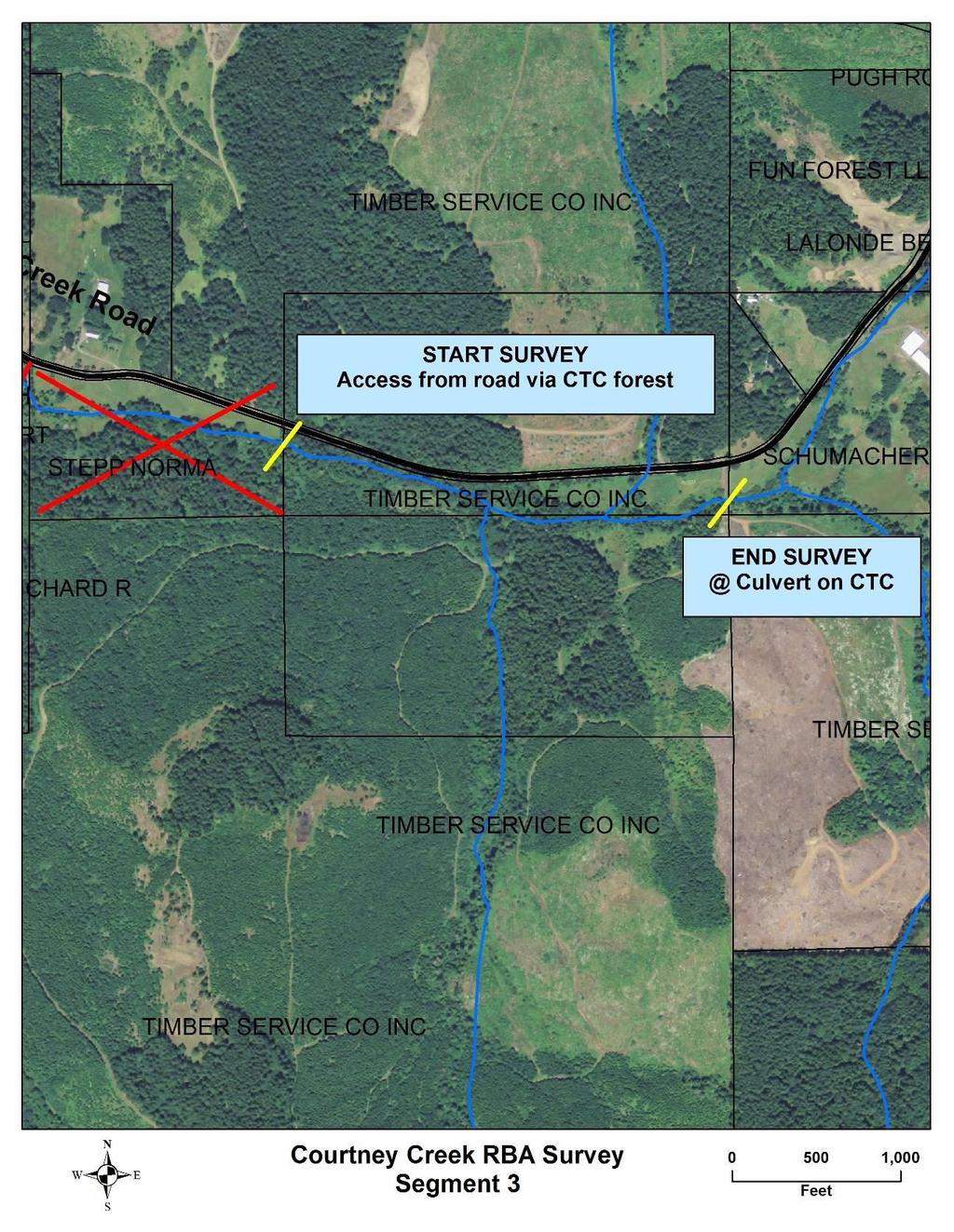
1 Calapooia Basin RBA Snorkel Survey Brief Surveys conducted by Bio-Surveys, LLC. (Steve Trask and Conrad Gowell) Analysis and Reporting prepared by: Steve Trask / Senior Fish Biologist Introduction Project Funded by: Calapooia Watershed Council A large wood placement project was implemented in Brush Cr and its 2 major contributing tributaries (WF Brush and Childers Cr) in September of A total of 342 logs were placed by excavator in approximately 5.7 stream miles. Just prior to this wood placement, a comprehensive pre project snorkel inventory was conducted in the Brush Cr sub basin to describe the distribution and abundance of salmonids so that a baseline could be established for future project effectiveness monitoring. To begin post project monitoring of this significant restoration action, a replicate snorkel survey was conducted 1 year later in the Brush Cr subbasin. This comparison was designed to quantify any potential changes in the abundance and distribution of salmonids associated with the increase in the abundance of full spanning wood. Due to fiscal constraints, a portion of the Brush Cr mainstem was dropped in the post project inventory (2.4 miles). The section dropped was in the mainstem of Brush Cr below any of the structure sites installed in The excluded reach extended from the confluence of the WF Brush Cr to the upstream edge of the power line crossing on the Melcher property. This review also includes the results of the 2014 pre project RBA snorkel inventory of a select reach of Courtney Cr, a tributary of the mainstem Calapooia. The selected reach was identified as a potential target for restoration and a pre project baseline of salmonid distribution and abundance was the primary objective of the inventory effort. The beginning and end points of the target reach have been identified in attachment 1 of this document. Results Table 1 presents the relative abundance of each salmonid species and age class observed in the targeted stream reaches. The table also includes inter annual comparisons of abundance for Brush Cr, WF Brush Cr and Childers Cr. The estimates of abundance are based on an expansion of the 20% sample of pool habitats only (riffles / rapids / glides not sampled) and therefore are not meant to represent a population estimate for any of the salmonid species.
2 Table 1 Stream 0+ % of total Sthd % of total Cutthroat % of total *Brush 2013 Pre % 5 50% % *Brush 2014 Post % % WF Brush 2013 Pre % WF Brush 2014 Post % Childers 2013 Pre % 5 50% % Childers 2014 Post % % Courtney Pre Courtney Trib B Pre *Brush Cr surveys normalized to represent similar survey lengths Table 1 also contains the results of the pre project inventory in Courtney Cr and its primary headwater tributary (Trib B). Brush Cr A significant observation from the 2 year inventory in the Brush Cr subbasin is the current lack of steelhead utilizing the system for spawning and rearing. No steelhead parr were observed in 2014 and only 2 were observed in 2013 (expanded to 10 from the 20% sub sample). This suggests that for both the 2011 and 2012 brood years, there were no adult steelhead that spawned anywhere in the Brush Cr subbasin. The observations of steelhead parr in 2013 were likely upstream migrants from the mainstem Calapooia (a common strategy for summer survival in temperature limited tributaries of the Willamette). Cutthroat abundance in the Brush Cr subbasin would be classified as low with average reach densities in both sampled years ranging between 0.02 and 0.04 fish / Sqm of pool surface area (the highest average density, 0.04 fish /sqm, was observed in Childers Cr in the post project year). The basin wide abundance of cutthroat between years only varied 5% with a basin total of 510 in 2013 and 485 in This is well within the range of the variability associated with the snorkel methodology and suggests no measurable change in abundance between the pre and post project inventory. An interesting observation between the pre and post project year was that the pool occupancy rates remained the same (occupancy = % of pools containing at least 1 older age class cutthroat) in mainstem Brush before and after the project (49% to 50%) but the occupancy rate increased in both Childers Cr (33% to 43%) and WF Brush Cr (26% to 48%) post project. This suggests that although the absolute abundance of Cutthroat has yet to exhibit a significant increase, the distribution of cutthroat has been altered by restoration to favor the higher gradient tributary habitats. It follows that the meta
3 Fish / Sqm population of 1+ and older age class cutthroat encompasses the entire Brush Cr subbasin and that population structure should be viewed on the larger spatial scale. In this example, it is possible that 1+ and older cutthroat that may have historically occupied lower Brush Cr summer habitats are currently being retained in headwater tributaries at a higher rate as a result of the increase in complexity and roughness associated with wood placement. Figure 1 Brush Cr Cutthroat Densities Cuts 2014 Cuts 2013 Trend 2014 Trend Distance from Confluence of WF Brush Cr Childers Cr Figure 2 below exhibits the comparative distribution of cutthroat between pre and post project years. Both years indicate the presence of an upstream temperature dependant migration from the mainstem of Brush Cr. There is also an observed increase in occupancy and abundance in the highest reaches of the inventory on BLM ownership that is likely a response to the increase in roughness and wood complexity associated with restoration actions.
4 Fish / Sqm Figure 2 Childers Cr Cutthroat Density Begin restoration reach 2013 Cuts 2014 Cuts 2013 Trend 2014 Trend Total Distance from Mouth (ft) Restoration actions in Childers Cr did not begin until approximately RM 0.6. The trend lines in Figure 2 reflect the interannual changes in average pool density which is heavily influenced by occupancy rates. There is a minor improvement in average pool density between years that is related to more pools being occupied in 2014 (60 %) than in 2013 (33%). This is a trend that suggests the increase in habitat complexity associated with wood placement has improved habitat utilization on the reach scale. It is also interesting that the observed improvements occur in the restored segment of Childers and not the unrestored segment (figure 2). The absolute number of 1+ and older age cutthroat in Childers Cr declined by 15% between the pre and post project years. This decline could be the result of many sources of variation (changes in aquatic temperature profiles that influence the recruitment of fluvial cutthroat from the mainstem Calapooia, variation in interannual spawning success, etc). It is premature to judge the efficacy of the LWD placement project as it relates to impacts associated with cutthroat abundance. This level of post project evaluation should occur at the 5 year interval as structures mature and develop the characteristics that they were designed to deliver (spawning gravel aggradation, channel braiding, impoundment and deep pool scour). At the 5 year interval, nearly a full cutthroat life cycle has been played out with improvements in survival accumulating for each subsequent year class.
5 Fish / Sqm WF Brush Cr The WF of Brush Cr exhibited a completely different response than observed in Childers Cr. Comparisons between the 2 sampled years exhibit a 150% increase in the abundance of cutthroat (table 1), an increase in pool occupancy rates (26% to 48%) and a doubling in the average pool density (0.01 to 0.02 fish / sqm). Although the distribution pattern of cutthroat observed in figure 3 does not suggest the presence of a temperature dependant migration of cutthroat into WF Brush from the mainstem of Brush Cr, there is a quantifiable increase observed when comparing the pre and post project abundance of cutthroat trout. Temperatures recorded in both WF Brush and Brush Cr were identical (15 deg C) at the time of the survey on August 25, Figure 3 WF Brush Cr Cutthroat densities Cuts 2014 Cuts Total Distance from Mouth (Ft) Most striking in WF Brush Cr was the complete absence of the 0+ age class of cutthroat in both sampled years which suggests that spawning success remains very low. The observed increase in cutthroat abundance in WF Brush Cr may be the result of multiple factors related to restoration actions (large woody debris placements) and to a change in water management as a result of land owner participation (dam board removal). It is important to note that the primary agricultural landowner on lower WF Brush Cr while partnering to conduct instream restoration, simultaneously altered the timing of dam board installation and removal on 2 formerly impassable irrigation dams within the restored reach. The agreement reached with the CWC was that dam boards would be completely removed from both of the irrigation dams between December 1 and July 1 each year to facilitate open access for spawning migrations of fluvial and anadromous
6 salmonids from the mainstem of Brush Cr or the Calapooia mainstem. Based on cutthroat migration studies done in other Willamette basin tributaries (Beaver Cr, Marys River, Thompson Dam, VanDewetering), fluvial cutthroat spawning migrations can extend between December and June. While it may not be imperative to provide access for the entire fluvial migration window to sustain viability, broad temporal variation maximizes genetic diversity, increasing resilience. Courtney Cr A pre-project RBA inventory was conducted on Courtney Cr and its primary unnamed headwater tributary (Trib B) between August 29 and Sept 3, This inventory was conducted to inform the development and design of an instream restoration project that would potentially span up to 5 river miles including 0.2 miles of Trib B. The timing of the inventory was scheduled to coincide with peak summer temperature profiles to assist in our understanding of how stream temperatures and flow currently limit the abundance of functional summer rearing habitat in the mainstem of Courtney Cr. It is important to recognize that the start point of the inventory was high in the basin and the result of a preliminary scoping exercise conducted by the CWC to identify the portion of the Courtney Cr subbasin that may retain some level of natural function capable of supporting salmonids (the top aquatic predator utilized as the primary indicator species of system function). The survey began at a bridge crossing on Courtney Cr at road mile 1.0 on Courtney Cr Drive. This point was approximately 17 river miles from the confluence of Courtney Cr with the mainstem Calapooia. This lineal distance includes the streams traverse across almost exclusively low gradient farm land and at least 7.7 miles of Walton and Shedd sloughs. Some of the implications of this lower stream morphology and land use are reviewed in the discussion section. Results The first 0.9 miles of the inventoried stream segment (which begins at RM 17) encountered only isolated pool habitats with no contiguous surface flow. Some of the isolated pools were as far as 1,000 ft apart separated by only dry stream bed. Figure 4 describes the stark absence of any salmonids in this portion of Courtney Cr. In addition, there were no cutthroat observed for 1.7 miles even though pools became linked 0.9 miles above the start point. Many dead and dying fish of all species (cutthroat, lamprey, red side shiner) were observed in this first 1.7 miles of the inventory. Essentially these habitats were experiencing high mortalities as summer flows subsided, water temperatures soared and DO levels decreased. When the linkage to headwater refugia are terminated, mortalities are significant and non discriminate. Temperatures in this first 1.7 miles were highly variable between 16 and 21 deg C. The variation was associated with the variable pool depths in each of the isolated pools. Deeper pools were accessing a higher percentage of the available hyporheic linkage. Cutthroat started to be present 1.7 miles above the start point at a point where surface flows relinked isolated pool habitats. At mile 2.2 above the survey start point a cold ground water seep joined a 5 ft deep pool that provided thermal refuge for upstream
7 Fish / Sqm migrants seeking thermal refuge from warm and nearly isolated habitats downstream. There were a total of 64 cutthroat observed in this pool (92% were 2+ and older adults). 420 feet above this pool was a smaller pool with 28 cutthroat (100% 2+ and older adults). Many of these older age class cutthroat were in the 16 inch range suggesting the presence of a fluvial life history strategy in the subbasin. This suggests that even fluvial cutthroat in the system are being forced out of the lower basin toward headwater thermal refugia during low summer flows suggesting the absence of lower basin thermal refugia (viable ground water seeps from the loss of wetland storage) or the existence of an upper threshold in some water quality parameter being reached in the lower Courtney Cr system. The abnormally high density of older age class cutthroat is a clear indication of a temperature dependant upstream migration from the lower mainstem to thermal refugia in the headwaters. This conclusion is corroborated by the presence of equally high densities of cutthroat below an 8 inch perched culvert at 3.8 miles above the start point (figure 4). The last observation of significance was the absence of cutthroat in the last ½ mile of the surveyed mainstem. This is an usual pattern of distribution with cutthroat densities usually increasing in headwater reaches as water quality parameters improve (Temperature, DO, etc). The presence of a dense overstory of stream adjacent blackberry has created a condition that deprives the aquatic corridor from solar influence which terminates the potential for primary productivity. In addition, substrates in the reach were clay dominated and providing limited opportunity for algal development or macro invertebrate colonization. Figure 4 Courtney Cr Cutthroat Density Distance above 1st bridge on Courtney Cr drive (RM 17)
8 Discussion There are basin scale issues that likely influence the observed results that are important to identify. If we assume that Courtney Cr continues to display multiple cutthroat life history strategies (resident and fluvial) then some consideration needs to be given to the concept of seasonal habitat linkage. To review, the fluvial life history dictates that cutthroat (variable age classes) drop out of higher gradient headwater reaches to rear in lower basin stream segments that offer a greater potential for rapid growth (access to a larger and more diverse food base and the opportunity to optimize temperature profiles). These outmigrants must return as adults to headwater reaches for spawning and incubation because of the underlying gradient of the lower reaches that is incapable of sorting viable spawning gravels. This upstream migration requires the basic necessity of contiguous flows that exhibit adequate water quantity and quality for completing the migration between habitats. So very little is known about the timing, range and duration of this fluvial life history that it is impossible for us at this juncture with our limited knowledge base to develop a relationship between the current levels of observed dysfunction and the environmental conditions that create them or exacerbate them. However, it is safe to say that there are multiple issues at play that when combined create catastrophic conditions for the fluvial life history and the linkages between the lower and upper basin that are necessary to maintain viability. As landowners and organizations move together corporately to restore system function, it is important to have some of these issues at least identified as potential vectors of the observed dysfunction. A short list would include water quantity, water quality and access for unimpeded summer and winter migration. The water quantity issues involve the loss of wetland habitats necessary for seasonal and groundwater storage and excessive agricultural and domestic irrigation during pinch period low summer flows. It is clear from the late August inventory that massive mortalities in the standing crop of cutthroat (both fluvial and resident) are occurring in Courtney Cr associated with some combination of these two issues that is resulting in a completely dry channel that terminates access to critical thermal refuge in the headwaters. One of the significant observations from the inventory was the differential pool temperatures observed within the isolated pools of the lower 1.7 miles of Courtney above the start point. Deeper pools were accessing a higher percentage of the hyporheic flow sequestered in the accumulated gravel lens providing at least temporary thermal refugia. For this stream segment, log structures should be designed to scour into the existing bedload for the provision of deeper and higher quality thermal refugia. Additional aggradation within this stream segment from the application of full spanning structures would likely exacerbate the current problem. Isolated pools would be less abundant and dry out quicker. Concentrating some effort in the reach upstream of the identified dry channel for the development of off channel wetland restoration to recharge ground water sources would be a high priority restoration objective. In addition, the development of alternate irrigation solutions or the retirement of water rights through the purchase of conservation easements would also be a high priority restoration objective above the observed dry channel reach.

9 Attachment 1

10
11
Columbia Estuary Province
 Rolling Provincial Review: Implementation 2001-2004 Province 73 Columbia Basin Fish & Wildlife Authority Province FY 2001-2004 Spending Summaries NPCC Recommendations and BPA Spending by Project Category,
Lower South Fork McKenzie River Floodplain Enhancement Project
 Lower South Fork McKenzie River Floodplain Enhancement Project McKenzie River Ranger District Willamette National Forest Project Location The project is located in the South Fork McKenzie River Watershed,
Conceptual Model of Stream Flow Processes for the Russian River Watershed. Chris Farrar
 Conceptual Model of Stream Flow Processes for the Russian River Watershed Chris Farrar Several features of creeks affect the interactions between surface and groundwater. This conceptual model uses the
Mobrand to Jones and Stokes. Sustainable Fisheries Management Use of EDT
 Sustainable Fisheries Management Use of EDT Ecosystem Diagnosis and Treatment EDT EDT designed to provide a practical, science-based approach for developing and implementing watershed plans. Provides decision
Evaluation of Geomorphic Effects of Removal of Marmot and Little Sandy Dams and Potential Impacts on Anadromous Salmonids
 PRELIMINARY FINAL Evaluation of Geomorphic Effects of Removal of Marmot and Little Sandy Dams and Potential Impacts on Anadromous Salmonids Prepared for: Portland General Electric 121 SW Salmon Street
Step 5: Channel Bed and Planform Changes
 Step 5: Channel Bed and Planform Changes When disturbed, streams go through a series of adjustments to regain equilibrium with the flow and sediment supply of their watersheds. These adjustments often
The Effects of Geomorphology and Watershed Land Use on Spawning Habitat
 The Effects of Geomorphology and Watershed Land Use on Spawning Habitat By Evan Buckland INTRODUCTION The distribution and frequency of large geomorphic features in a watershed govern where suitable spawning
ODFW AQUATIC INVENTORY PROJECT OREGON PLAN FOR SALMON & WATERSHEDS STREAM RESTORATION HABITAT REPORT
 ODFW AQUATIC INVENTORY PROJECT OREGON PLAN FOR SALMON & WATERSHEDS STREAM RESTORATION HABITAT REPORT STREAM: BASIN: SURVEY TYPE: Munson Creek (NC-342) Tillamook River Post-Tx DATE: February 2, 28 SURVEY
Executive Summary. Water Quantity
 Executive Summary Stakeholders in the Rock-Glade Watershed have taken the initiative to proceed with watershed planning as provided by the State of Washington under the Watershed Management Act (Chapter
Upper Manistee River Instream Fish Habitat Assessment
 1 Upper Manistee River Instream Fish Habitat Assessment Michigan Trout Unlimited January 216 Kristin Thomas Dr. Bryan Burroughs 2 Table of Contents INTRODUCTION... 4 Table 1. Michigan stream and river
Addressing the Impact of Road-Stream Crossing Structures on the Movement of Aquatic Organisms
 Scott Jackson University of Massachusetts Amherst Addressing the Impact of Road-Stream Crossing Structures on the Movement of Aquatic Organisms Dams Sub-standard Culverts Excessive Velocities Inlet Drop
ADDRESSING GEOMORPHIC AND HYDRAULIC CONTROLS IN OFF-CHANNEL HABITAT DESIGN
 ADDRESSING GEOMORPHIC AND HYDRAULIC CONTROLS IN OFF-CHANNEL HABITAT DESIGN Conor Shea - Hydrologist U.S. Fish and Wildlife Service Conservation Partnerships Program Arcata, CA Learning Objectives Examine
Case Study 2: Twenty-mile Creek Rock Fords
 Case Study : Twenty-mile Creek Rock Fords Location Crossing Description Washington. Okanagan National Forest. Methow Valley Ranger District. Chewuch river basin, East Chewuch Road. The Twenty-mile Creek
APPENDIX A REACH DECRIPTIONS. Quantico Creek Watershed Assessment April 2011
 APPENDIX A REACH DECRIPTIONS Basin 615, South Fork of Quantico Creek - Project Reach Descriptions Reach Name: 615-A Coordinates (NAD 83, Virginia State Plane North): 11796510.57, 6893938.95 to 11801555.79,
Kootenai River Habitat Restoration Program Update
 Kootenai River Habitat Restoration Program Update Kootenai Tribe of Idaho Kootenai Valley Resource Initiative November 19, 2012 Bonners Ferry, Idaho Changes to Kootenai Basin Beaver trapping Floodplain
Black Gore Creek 2013 Sediment Source Monitoring and TMDL Sediment Budget
 Black Gore Creek 2013 Sediment Source Monitoring and TMDL Sediment Budget Prepared for: Prepared By: - I. Introduction The Black Gore Creek Total Maximum Daily Load (TMDL) was developed in collaboration
Restoring the Napa River:
 Restoring the Napa River: lessons learned from a long term private-public project Andy Collison Environmental Science Associates acollison@esassoc.com 1 Napa River Restoration Projects Rutherford Reach
CR AAO Bridge. Dead River Flood & Natural Channel Design. Mitch Koetje Water Resources Division UP District
 CR AAO Bridge Dead River Flood & Natural Channel Design Mitch Koetje Water Resources Division UP District Old County Road AAO Bridge Map courtesy of Marquette County Silver Lake Basin McClure Basin
Final Report for the Green Valley Creek Winter Refugia Enhancement Project Monitoring December 2016
 Final Report for the Green Valley Creek Winter Refugia Enhancement Project Monitoring December 2016 Prepared by: Mariska Obedzinski and Sarah Nossaman University of California Cooperative Extension & California
Blue Mountain Province
 Rolling Provincial Review: Implementation 2001-2003 Province 23 Columbia Basin Fish & Wildlife Authority Province FY 2001-2003 Spending Summaries NPCC Recommendations and BPA Spending by Project Category,
ODFW AQUATIC INVENTORY PROJECT OREGON PLAN FOR SALMON & WATERSHEDS STREAM RESTORATION HABITAT REPORT
 ODFW AQUATIC INVENTORY PROJECT OREGON PLAN FOR SALMON & WATERSHEDS STREAM RESTORATION HABITAT REPORT STREAM: BASIN: SURVEY TYPE: South Sister Creek (U-5) Smith River Pre-Tx DATE: January 7, 4 SURVEY CREW:
Solutions to Flooding on Pescadero Creek Road
 Hydrology Hydraulics Geomorphology Design Field Services Photo courtesy Half Moon Bay Review Solutions to Flooding on Pescadero Creek Road Prepared for: San Mateo County Resource Conservation District
Ecosystem response during the removal of the Elwha River Dams
 Ecosystem response during the removal of the Elwha River Dams Presentation Prepared by George Pess - NOAA Photo by John McMillan December 2015 Elwha The Elwha River Basin Olympic Natl. Park > 90% of habitat
GENERAL SUMMARY BIG WOOD RIVER GEOMORPHIC ASSESSMENT BLAINE COUNTY, IDAHO
 GENERAL SUMMARY BIG WOOD RIVER GEOMORPHIC ASSESSMENT BLAINE COUNTY, IDAHO Prepared For Trout Unlimited 300 North Main Street, Hailey, Idaho, 83333 Prepared By P. O. Box 8578, 140 E. Broadway, Suite 23,
APPENDIX E. GEOMORPHOLOGICAL MONTORING REPORT Prepared by Steve Vrooman, Keystone Restoration Ecology September 2013
 APPENDIX E GEOMORPHOLOGICAL MONTORING REPORT Prepared by Steve Vrooman, Keystone Restoration Ecology September 2 Introduction Keystone Restoration Ecology (KRE) conducted geomorphological monitoring in
Stream Simulation: A Simple Example
 Stream Simulation: A Simple Example North Thompson Creek, CO Paul T. Anderson U.S.D.A. Forest Service Here s How We Started May 2011 2-1 USDA-Forest Service Here s How We Finished Forest Service Aquatic
DETAILED DESCRIPTION OF STREAM CONDITIONS AND HABITAT TYPES IN REACH 4, REACH 5 AND REACH 6.
 DETAILED DESCRIPTION OF STREAM CONDITIONS AND HABITAT TYPES IN REACH 4, REACH 5 AND REACH 6. The Eklutna River was divided into study reaches (figure 1) prior to this site visit. Prominent geologic or
Coarse Sediment Augmentation on Regulated Rivers. Scott McBain McBain & Trush, Inc.
 Coarse Sediment Augmentation on Regulated Rivers Scott McBain McBain & Trush, Inc. scott@mcbaintrush.com Components Some geomorphic and ecological considerations Conceptual approach at understanding augmentation
-- Lessons from a successful salmon stream and estuary relocation on Gravina Island
 Re-inventing Government Creek -- Lessons from a successful salmon stream and estuary relocation on Gravina Island Jon Houghton, Ph.D. and Derek Ormerod, M.S., P.E. - Pentec Environmental/Hart Crowser,
Channel and Fish Response to the. East Fork Hooper Creek Culvert Removal
 Channel and Fish Response to the East Fork Hooper Creek Culvert Removal October 31, 212 Jeff Phillips, Michael Olis, and Curt Veldhuisen Forest and Fish Program Skagit River System Cooperative La Conner,
Fluvial Driven Alluvial Fans
 Fluvial Driven Alluvial Fans Restoration Project Evaluations - Examples from the Russian and Napa River Watersheds Mia Docto Masters Thesis UC Berkeley 1. Basic Fan Description 2. Fluvial Driven Fan Characteristics
Start of Presentation: No notes (Introductory Slide 1) 1) Salmonid Habitat Intrinsic Potential (IP) models are a type of habitat potential
 1) Salmonid Habitat Intrinsic Potential (IP) models are a type of habitat potential") The What and How of Salmonid Habitat Intrinsic Potential Modeling Start of Presentation: No notes (Introductory Slide 1) 1) Salmonid Habitat Intrinsic Potential (IP) models are a type of habitat potential
The What and How of Salmonid Habitat Intrinsic Potential Modeling Start of Presentation: No notes (Introductory Slide 1) 1) Salmonid Habitat Intrinsic Potential (IP) models are a type of habitat potential
The Refugia Concept: Using Watershed Analysis to Prioritize Salmonid Habitat for Conservation and Restoration
 The Refugia Concept: Using Watershed Analysis to Prioritize Salmonid Habitat for Conservation and Restoration Christopher May Battelle & UW Cumulative Impacts of Urbanization Landscape Alterations Loss
ODFW AQUATIC INVENTORY PROJECT RESTORATION MONITORING STREAM HABITAT REPORT. Peggy Kavanagh, Trevan Cornwell TOLEDO SOUTH Coast Range Lora Tennant
 ODFW AQUATIC INVENTORY PROJECT RESTORATION MONITORING STREAM HABITAT REPORT STREAM: GCG: 2-MC SITE ID: 489 BASIN: YAQUINA TREATMENT DATE: 24 SURVEY DATE: 2/27/24 SURVEY CREW: USGS MAPS: ECOREGION: REPORT
Little Blackfoot TPA 2009 Sediment and Habitat Assessment QAQC Review March 9, 2010
 Little Blackfoot TPA 2009 Sediment and Habitat Assessment QAQC Review March 9, 2010 1.0 PROJECT OVERVIEW Sediment and habitat monitoring in the Little Blackfoot TPA was conducted in July of 2009 as outlined
Elwha River response to dam removals through four years and a big flood:
 Elwha River response to dam removals through four years and a big flood: Lessons learned, channel response, and sediment effects from the world s largest engineered dam removal Andy Ritchie NPS Elwha Restoration
Dan Miller + Kelly Burnett, Kelly Christiansen, Sharon Clarke, Lee Benda. GOAL Predict Channel Characteristics in Space and Time
 Broad-Scale Models Dan Miller + Kelly Burnett, Kelly Christiansen, Sharon Clarke, Lee Benda GOAL Predict Channel Characteristics in Space and Time Assess Potential for Fish Use and Productivity Assess
Wetland & Floodplain Functional Assessments and Mapping To Protect and Restore Riverine Systems in Vermont. Mike Kline and Laura Lapierre Vermont DEC
 Wetland & Floodplain Functional Assessments and Mapping To Protect and Restore Riverine Systems in Vermont Mike Kline and Laura Lapierre Vermont DEC NWI+ Hydro-Geomorphic Characterization of Wetlands and
SECTION G SEDIMENT BUDGET
 SECTION G SEDIMENT BUDGET INTRODUCTION A sediment budget has been constructed for the for the time period 1952-2000. The purpose of the sediment budget is to determine the relative importance of different
Russian River Independent Science Review Panel
 Russian River Independent Science Review Panel Laurel Marcus Executive Director Ca. Land Stewardship Institute (CLSI) Fish Friendly Farming Certification Program 550 Gateway Dr. #108 Napa, Ca. 94558 707
Appendix G. Meso-Habitat Surveys. DRAFT Annual Technical Report
 Appendix G Meso-Habitat Surveys DRAFT Annual Technical Report Draft March 2010 1.0 Introduction 1 2 3 4 5 6 1.0 Introduction The following appendix includes a report provided by the California Department
Modeling Fish Assemblages in Stream Networks Representation of Stream Network Introduction habitat attributes Criteria for Success
 Modeling Fish Assemblages in Stream Networks Joan P. Baker and Denis White Western Ecology Division National Health & Environmental Effects Research Laboratory U.S. Environmental Protection Agency baker.joan@epa.gov
Appendix 10. Habitat Suitability Criteria. Prepared by: Rushing Rivers Institute
 Appendix 10 Habitat Suitability Criteria Prepared by: Rushing Rivers Institute December 2009 Habitat Suitability This appendix describes the details of determining habitat suitability criteria for selected
RAILWAYS AND FISH: HOW TO PROTECT AND ENHANCE FISH HABITAT VALUES AT STREAM CROSSINGS THROUGH PROJECT DESIGN AND CONSTRUCTION
 RAILWAYS AND FISH: HOW TO PROTECT AND ENHANCE FISH HABITAT VALUES AT STREAM CROSSINGS THROUGH PROJECT DESIGN AND CONSTRUCTION Rail Environment Conference November 2016 AGENDA Objective Background Benefits
Influence of the Major Drainages to the Mississippi River and Implications for System Level Management
 Influence of the Major Drainages to the Mississippi River and Implications for System Level Management Brian M. Vosburg Geologist Louisiana Coastal Protection and Restoration Authority brian.vosburg@la.gov
Assignment 1. Measuring River Characteristics- Vernon Creek. Applied Fluvial Geomorphology Field Techniques EESc 435
 Assignment 1 Measuring River Characteristics- Vernon Creek Applied Fluvial Geomorphology Field Techniques EESc 435 Amanda Jardine 30100093 Jaime McDonald 14177083 Erica Massey 50870088 April 28, 2012 Introduction
Stream Geomorphology. Leslie A. Morrissey UVM July 25, 2012
 Stream Geomorphology Leslie A. Morrissey UVM July 25, 2012 What Functions do Healthy Streams Provide? Flood mitigation Water supply Water quality Sediment storage and transport Habitat Recreation Transportation
Phase I System Characterization: Year 2 Study Plans
 Phase I System Characterization: Year 2 Study Plans Year I Physical and Biological Data Sets Quarterly Storm Sampling Four storm events with 8 sample stations at bridges Monthly Baseline Characterization
Why Geomorphology for Fish Passage
 Channel Morphology - Stream Crossing Interactions An Overview Michael Love Michael Love & Associates mlove@h2odesigns.com (707) 476-8938 Why Geomorphology for Fish Passage 1. Understand the Scale of the
SCOPE OF PRESENTATION STREAM DYNAMICS, CHANNEL RESTORATION PLANS, & SEDIMENT TRANSPORT ANALYSES IN RELATION TO RESTORATION PLANS
 DESIGN METHODS B: SEDIMENT TRANSPORT PROCESSES FOR STREAM RESTORATION DESIGN PETER KLINGEMAN OREGON STATE UNIVERSITY CIVIL ENGINEERING DEPT., CORVALLIS 2 ND ANNUAL NORTHWEST STREAM RESTORATION DESIGN SYMPOSIUM
7. Management Plan. Terrestrial Habitats. Research, Monitoring and Evaluation
 7. Management Plan As the core of the subbasin plan, the management plan contains the direction in which the subbasin needs to proceed in the future regarding enhancement of aquatic and terrestrial habitats
Upper Mississippi River Basin Environmental Management Program Workshop
 Presentation to the Upper Mississippi River Basin Environmental Management Program Workshop by Michael Rodgers River Engineer US Army Corps of Engineers, St. Louis District August 17, 2007 Engineering
Diagnostic Geomorphic Methods for Understanding Future Behavior of Lake Superior Streams What Have We Learned in Two Decades?
 Diagnostic Geomorphic Methods for Understanding Future Behavior of Lake Superior Streams What Have We Learned in Two Decades? Faith Fitzpatrick USGS WI Water Science Center, Middleton, WI fafitzpa@usgs.gov
The River Continuum Concept (or not?) Stream Classification
 Stream Classification") The River Continuum Concept (or not?) Stream Classification Goal: Generalization 2 general types of classification streams (longitudinal) streams (e.g., hydrologic regime classification) Longitudinal Classification
The River Continuum Concept (or not?) Stream Classification Goal: Generalization 2 general types of classification streams (longitudinal) streams (e.g., hydrologic regime classification) Longitudinal Classification
Fish Passage at Road Crossings
 Fish Passage at Road Crossings 1 Crossing Design Workshop Outline 1:00 to 2:00 Intro, Design Overview, Channel Width 2:00 to 2:15 Break 2:15 to 3:15 No-Slope, Stream Simulation Design 3:15 to 3:30 Break
L OWER N OOKSACK R IVER P ROJECT: A LTERNATIVES A NALYSIS A PPENDIX A: H YDRAULIC M ODELING. PREPARED BY: LandC, etc, LLC
 L OWER N OOKSACK R IVER P ROJECT: A LTERNATIVES A NALYSIS A PPENDIX A: H YDRAULIC M ODELING PREPARED BY: LandC, etc, LLC TABLE OF CONTENTS 1 Introduction... 1 2 Methods... 1 2.1 Hydraulic Model... 1 2.2
Opportunities to Improve Ecological Functions of Floodplains and Reduce Flood Risk along Major Rivers in the Puget Sound Basin
 Opportunities to Improve Ecological Functions of Floodplains and Reduce Flood Risk along Major Rivers in the Puget Sound Basin Christopher Konrad, US Geological Survey Tim Beechie, NOAA Fisheries Managing
Savannah District s Revised SOP: Moving Towards A Functional Approach. US Army Corps of Engineers BUILDING STRONG
 Savannah District s Revised SOP: Moving Towards A Functional Approach US Army Corps of Engineers Agenda SOP Revision Concept New Aquatic Resource Credit Types New Urban Mitigation Service Area Filter Background
Stream Restoration and Environmental River Mechanics. Objectives. Pierre Y. Julien. 1. Peligre Dam in Haiti (deforestation)
") Stream Restoration and Environmental River Mechanics Pierre Y. Julien Malaysia 2004 Objectives Brief overview of environmental river mechanics and stream restoration: 1. Typical problems in environmental
Stream Restoration and Environmental River Mechanics Pierre Y. Julien Malaysia 2004 Objectives Brief overview of environmental river mechanics and stream restoration: 1. Typical problems in environmental
Appendix F Channel Grade Control Structures
 Stream Simulation Appendix F Channel Grade Control Structures This appendix briefly describes permanent grade control structures that are sometimes needed in the upstream and/or downstream reaches adjacent
Environmental Value. Low Moderate High
 Boulder Clusters by Craig Fischenich and Rebecca Seal February Complexity Environmental Value Cost Low Moderate High Low Moderate High Low Moderate High OVERVIEW Boulder clusters are groups of large rocks
ODFW AQUATIC INVENTORY PROJECT STREAM REPORT
 ODFW AQUATIC INVENTORY PROJECT STREAM REPORT STREAM: BASIN: South Fork Mill Creek Mill Creek / Columbia River DATES: September 7 9, 5 SURVEY CREW: REPORT PREPARED BY: Brian Bangs / LaNoah Babcock Staci
1 INTRODUCTION AND MAJOR FINDINGS... 1
 Memorandum To: Lindsey Clark, Stillwater Valley Watershed Council Coordinator From: Chad Raisland, Pioneer Technical Services, Inc. and Karin Boyd, Applied Geomorphology, Inc. CC: Tanya Lester, Stillwater
Use of benthic invertebrate biological indicators in evaluating sediment deposition impairment on the Middle Truckee River, California
 Use of benthic invertebrate biological indicators in evaluating sediment deposition impairment on the Middle Truckee River, California David B. Herbst Sierra Nevada Aquatic Research Laboratory University
Birch Creek Geomorphic Assessment and Action Plan
 Birch Creek Geomorphic Assessment and Action Plan Jim Webster Tim Hanrahan, PhD, CFM Jesse Schwartz, PhD Zach Hill January 22, 2015 White Eagle Grange This Project is a First Step in Strategy Planning
Design and Construction
 Design and Construction Stream Simulation With power point slides shamelessly stolen from: Forest Service AOP Training Course Bob Gubernick Paul Anderson John Kattell USDA Forest Service Interim Directive
Appendix III-A Descriptions of Channel Habitat Types
 Appendix III-A Descriptions of Channel Habitat Types Table of Contents Channel Habitat Typing Background... 3 Small Estuarine Channel (ES)... 7 Large Estuarine Channel (EL)... 9 Low Gradient Large Floodplain
ODFW AQUATIC INVENTORY PROJECT STREAM REPORT
 ODFW AQUATIC INVENTORY PROJECT STREAM REPORT STREAM: BASIN: Basin Creek Willow Creek DATE: July 9 3, 9 SURVEY CREW: REPORT PREPARED BY: USGS MAPS: ECOREGION: Nicole Bushey / Emily Zimmermann Staci Stein
APPENDIX 3B OCCURRENCE OF SIGNIFICANT RIVER ALLUVIUM AQUIFERS IN THE PLATEAU REGION
 Plateau Region Water Plan January 2011 APPENDIX 3B OCCURRENCE OF SIGNIFICANT RIVER ALLUVIUM AQUIFERS IN THE PLATEAU REGION Occurrence of Significant River Alluvium Aquifers in the Plateau Region Prepared
Channel Assessments of Selected Watersheds within TFL 52
 Channel Assessments of Selected Watersheds within TFL 52 prepared for: West Fraser Mills Ltd. Quesnel, BC prepared by: John Berry, M.Sc., R.P.F. Victoria, BC Channel Assessments TFL 52 Summary SUMMARY
In-channel coarse sediment trap Best Management Practice
 In-channel coarse sediment trap Best Management Practice By Henry R. Hudson July 2002 Environmental Management Associates Ltd., Christchurch Complexity Environmental Value Cost Low Moderate High Low Moderate
May Creek Canyon LWD Stream Restoration Project. Helicopter Placement of LWD in an Urban Stream. By Kathryn Neal, P.E.
 Helicopter Placement of LWD in an Urban Stream By Kathryn Neal, P.E. May Creek Canyon LWD Stream Restoration Project By Kathryn Neal, P.E. Project proponents: King County City of Renton City of Newcastle
Appendix I: The Summit-at-Snoqualmie Master Development Plan Proposal FEIS Physical and Biological Resource Data Tables
 Appendix I: The Summit-at-Snoqualmie Master Development Plan Proposal FEIS Physical and Biological Resource Data Tables DPC Tables Rationale for DPC Analysis Parameters for 7 th Field Watersheds for The
EAGLES NEST AND PIASA ISLANDS
 EAGLES NEST AND PIASA ISLANDS HABITAT REHABILITATION AND ENHANCEMENT PROJECT MADISON AND JERSEY COUNTIES, ILLINOIS ENVIRONMENTAL MANAGEMENT PROGRAM ST. LOUIS DISTRICT FACT SHEET I. LOCATION The proposed
Linking place, process and strategy: Basin-scale view of salmon and steelhead habitats and restoration projects in the Willamette Valley
 Linking place, process and strategy: Basin-scale view of salmon and steelhead habitats and restoration projects in the Willamette Valley Rose Wallick, James White, Mackenzie Keith, Krista Jones, Gabe Gordon,
Illinois State Water Survey Division
 Illinois State Water Survey Division SURFACE WATER SECTION SWS Miscellaneous Publication 108 SEDIMENT YIELD AND ACCUMULATION IN THE LOWER CACHE RIVER by Misganaw Demissie Champaign, Illinois June 1989
Technical Memorandum. To: From: Copies: Date: 10/19/2017. Subject: Project No.: Greg Laird, Courtney Moore. Kevin Pilgrim and Travis Stroth
 Technical Memorandum To: From: Greg Laird, Courtney Moore Kevin Pilgrim and Travis Stroth 5777 Central Avenue Suite 228 Boulder, CO 80301 www.otak.com Copies: [Electronic submittal] Date: 10/19/2017 Subject:
Tenmile Lakes Delta Building Study
 Tenmile Lakes Delta Building Study Since the late 1940 s, Tenmile Lakes has seen a sharp increase in sediment accumulation at the mouths of the tributaries that feed the lake. To monitor this sediment
Environmental. Plan Update. By Jodie Pavlica
 E i t l and d Environmental Recreational Analysis Snake Salt Basin Plan Update By Jodie Pavlica i for f oday s d Presentation P t ti opics 1. 2. 3. 4. 5. 6. Recreational and Environmental Uses in the Last
Black Gore Creek Sediment Source Monitoring and TMDL Sediment Budget
 Black Gore Creek 2012 Sediment Source Monitoring and TMDL Sediment Budget Prepared for: The Eagle River Watershed Council Prepared By: RiverRestoration.org - I. Introduction Interstate 70 is a major highway
Geomorphology Studies
 Geomorphology Studies Technical Workgroup Meeting February 14, 2012 Prepared by: Tetra Tech Prepared for: Alaska Energy Authority Overall Goal Geomorphology Studies Two studies Geomorphology Study (RSP
San Joaquin River Tributary Sediment Transport and Geomorphology Study
 Study 22 San Joaquin River Tributary Sediment Transport and Geomorphology Study Public Draft 2013 Monitoring and Analysis Plan September 2012 22.0 San Joaquin River Tributary Sediment Transport and Geomorphology
We are interconnected, we are resilient As air temperatures warm forests change, fires increase glaciers retreat, snowpack diminishes sediment
 We are interconnected, we are resilient As air temperatures warm forests change, fires increase glaciers retreat, snowpack diminishes sediment increases rivers change, salmon respond base sea level rises
low turbidity high turbidity
 What is Turbidity? Turbidity refers to how clear the water is. The greater the amount of total suspended solids (TSS) in the water, the murkier it appears and the higher the measured turbidity. Excessive
Four Mile Run Levee Corridor Stream Restoration
 Four Mile Run Levee Corridor Stream Restoration 30% Design Summary U.S. Army Corps of Engineers, Baltimore District Presentation Outline Four Mile Run 1.) Historic Perspective 2.) Existing Conditions 3.)
GARCIA RIVER SEDIMENT TOTAL MAXIMUM DAILY LOAD
 U.S. ENVIRONMENTAL PROTECTION AGENCY REGION IX GARCIA RIVER SEDIMENT TOTAL MAXIMUM DAILY LOAD MARCH 16, 1998 APPROVED BY: ORIGINAL SIGNED Alexis Strauss Date Acting Director Water Division EPA Region IX
Spring Run Spawning Habitat Assessment Sediment Mobility
 Study 47 Spring Run Spawning Habitat Assessment Sediment Mobility Final 2015 Monitoring and Analysis Plan January 2015 1.0 Spring Run Spawning Habitat Assessment Sediment Mobility Theme(s): Flow management
Assessment. Assessment
 2001 SPRINGBROOK CREEK RESTORATION - THREE YEAR POST-CONSTRUCTION REVIEW - Presented by Bruce Henderson and Andy Harris 2005 River Restoration Northwest Symposium Skamania Lodge, Washington www.hendersonlandservices.com
LAUREL MARCUS California Land Stewardship Institute OVERVIEW OF GROUNDWATER STUDIES IN THE RUSSIAN RIVER WATERSHED
 LAUREL MARCUS California Land Stewardship Institute OVERVIEW OF GROUNDWATER STUDIES IN THE RUSSIAN RIVER WATERSHED - 60% OF LAND AREA } 20% OF LAND AREA } 20% OF LAND AREA GEOLOGY OF THE RUSSIAN RIVER
Colony Creek Colony Mountain Drive Sediment Management and Flood Protection Evaluation Final Report
 Colony Creek Colony Mountain Drive Sediment Management and Flood Protection Evaluation Final Report Prepared for: Skagit County Department of Public Works Surface Water Prepared by: northwest hydraulic
STUDY PERFORMANCE REPORT
 STUDY PERFORMANCE REPORT State: Michigan Project No.: F-80-R-8 Study No.: 230702 Title: Effects of sediment traps on Michigan river channels Period Covered: October 1, 2006 to September 30, 2007 Study
Case Study 8. North Fork Nooksack River In-channel Project
 Case Study 8 Project Overview The North Fork Nooksack In-channel project was developed cooperatively between the USDA Forest Service and the Nooksack Salmon Enhancement Association (NSEA), with the objectives
DESCHUTES RIVER BANK STABILIZATION PROJECTS ASSESSMENT
 DESCHUTES RIVER BANK STABILIZATION PROJECTS ASSESSMENT Prepared for: Deschutes River Conservancy 700 NW Hill Street Bend, Oregon 97701 Prepared by: River Design Group, Inc. 6029 SW 33 rd Place Portland,
Physical modeling to guide river restoration projects: An Overview
 Physical modeling to guide river restoration projects: An Overview Scott Dusterhoff¹, Leonard Sklar², William Dietrich³, Frank Ligon¹, Yantao Cui¹, and Peter Downs¹ ¹Stillwater Sciences, 2855 Telegraph
Monitoring and evaluation of benthic macroinvertebrates in the Big Hole River and tributaries
 Monitoring and evaluation of benthic macroinvertebrates in the Big Hole River and tributaries Michael A. Bias Big Hole River Foundation Introduction BMI used to evaluate stream biological health Quantifies
The River Restoration Centre therrc.co.uk. Understanding Fluvial Processes: supporting River Restoration. Dr Jenny Mant
 The River Restoration Centre therrc.co.uk Understanding Fluvial Processes: supporting River Restoration Dr Jenny Mant Jenny@therrc.co.uk Understanding your catchment Hydrology Energy associated with the
How Do Human Impacts and Geomorphological Responses Vary with Spatial Scale in the Streams and Rivers of the Illinois Basin?
 How Do Human Impacts and Geomorphological Responses Vary with Spatial Scale in the Streams and Rivers of the Illinois Basin? Bruce Rhoads Department of Geography University of Illinois at Urbana-Champaign
Carmel River Bank Stabilization at Rancho San Carlos Road Project Description and Work Plan March 2018
 Carmel River Bank Stabilization at Rancho San Carlos Road Project Description and Work Plan March 2018 EXISTING CONDITION The proposed Carmel River Bank Stabilization at Rancho San Carlos Road Project
WATERSHED RESTORATION PLANNING AND PRIORITY SETTING. An Emphasis on Fish Habitat
 WATERSHED RESTORATION PLANNING AND PRIORITY SETTING An Emphasis on Fish Habitat March 2004 This document was modified from Planning and Priority Setting for the Next Five Years, Phase 3 Watershed-Level
Thank you to all of our 2015 sponsors: Media Partner
 Thank you to all of our 2015 sponsors: Media Partner Fluvial System Concepts and Their Application in Greenfield Stream Corridor Realignment Dr. Paul Villard, P.Geo. GEO Morphix Ltd. Overview Major realignment