Environmental. Plan Update. By Jodie Pavlica
|
|
|
- Maryann Nelson
- 5 years ago
- Views:
Transcription


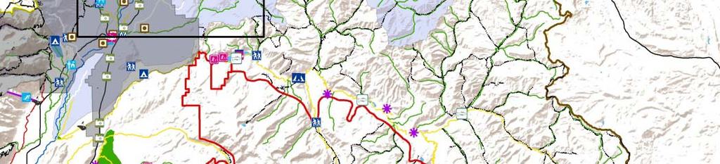
1 E i t l and d Environmental Recreational Analysis Snake Salt Basin Plan Update By Jodie Pavlica
2 i for f oday s d Presentation P t ti opics Recreational and Environmental Uses in the Last Plan raditional vs. Environmental and R Recreational ti l Uses U Environmental and Recreational Water Use Study New Approach Environmental and Recreational Use within the Update Draft Results Current Status and Remaining Items
3 P i B i Plan Pl Previous Basin Recreational opics in Previous Plan Grand eton National Park & Bridger eton National Forest & Ski A Areas and d Winter Wi t SSports t & Fishing & Waterfowl f l Hunting i &


4 P i B i Plan Pl Previous Basin Environmental opics p in Previous Plan Maintenance Flows P Wetlands Mapping pp g P Wetlands Projects P Snake River Restoration Project P Cutthroat management P Big Game Habitat P Salmon Recovery Effort P


5 P i B i Plan Pl Previous Basin Problems with this approach? he picture was here was no link between traditional,, recreational,, and environmental
6 i l and d Recreational i l Uses Environmental raditional Uses Have a water Right and a measurable diversion amount Environmental and Recreational Uses A considered Are id d nonconsumptive, i because they have no measureable diversion amount.
7 N A h New Approach Å 2010 Legislative Funding Æ Æ Æ o develop an approach to analyze Environmental and Recreational Uses Including their interaction with raditional Uses o develop a list of data needed o develop a list of data sources available Harveyy Economics Å 2012 Study Completed Å
8 N A h New Approach Steps Identification of Uses Map Uses Locate raditional Uses Categorize Uses on a Subbasin Scale Summarize on a Basin Scale


9 N A h New Approach 3 ypes off Environmental E i t l and dr Recreational ti lu Uses Protected hese uses are both recognized g and protected in some way from incursions by traditional water uses. Ex. Instream Flow S Segments, t Bypass B fl flows, Wild River Segments


10 N A h New Approach 3 ypes off Environmental E i t l and dr Recreational ti lu Uses Complementary hese uses exist without explicit protection but will continue to exist typically by protection, virtue of their location or linkage with a traditional water use. Ex. Spawning Habitat supported by return flow from Flood Irrigation. Ex. Uses in the National Forest that exist because of Federal Management. Management


11 N A h New Approach 3 ypes off Environmental E i t l and dr Recreational ti lu Uses Competing Competing uses are those environmental or recreational uses which are in a location where other traditional water use diverters may constrain or eliminate the environmental or recreational use at any point in time. Ex. Fishing segment below flood irrigation. If the irrigation is switched to sprinkler then the return flows will be dramatically reduced and may result in portions of the year with little or no water in the stream
12 Update Procedure Step 1 Gather Data Game and Fish Bridger eton National Forest (Wild and Scenic River Site) C ib h National Caribou arghee N ti l Forest Fish and Wildlife Service National Park Service he Nature Conservancy Yellowstone and Grand eton National Parks rout Unlimited State Engineer s Office Wyoming Department of ourism
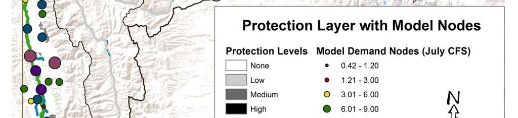
13 Step 2 Map Uses GIS Layer Name Source Aquatic Habitat Priority Areas Bridger eton Sites Bridger eton rails Caribou arghee Dispersed Areas Caribou arghee Dispersed Sites Caribou arghee Sites Elk Feed Grounds Fishing Spots Game and Fish Stream Classifications Golf Courses Grand eton National Park Resources Instream Flows l Lakes Landownership Model Demand Nodes National Wetlands Inventory Nature Conservancy Easements Non Nature Conservancy Easements Palisades Wilderness Study Area Scenic Highways and Byways Shoal Creek Wilderness Study Area Ski Areas Streams eton County Ponds t Unlimmited rout U li it d Projects P j t Wild and Scenic Rivers Wilderness Areas Yellowstone National Park Resources Wyoming Game and Fish Bridger eton National Forest Bridger eton National Forest Caribou arghee National Forest Caribou arghee National Forest Caribou arghee National Forest Wyoming Game and Fish WyGISC Wyoming Game and Fish WyGISC National Park Service WWDO, SEO, Game & Fish h WSGS BLM WWDO Fish and Wildlife Service he Nature Conservancy he Nature Conservancy Bridger eton and Caribou arghee National Forests WyGISC and ESRI Bridger eton National Forest WyGISC WSGS SEO t Unlimmited rout U li it d SEO WyGISC National Park Service
14 Step 2 - Map Uses What do you do about overlapping layers? Use Layer Wyoming Game and Fish Stream Classifications Instream Flow Application Segments Wyoming Game and Fish Critical Streams National Wild and Scenic Rivers Land Ownership Protection Layer F Permitted Instream Flow Segments F National Wild and Scenic River Segments F Land Ownership * Important: hese are only 5 of the 28 GIS layers that were used in this analysis. he GIS Layers that were developed by this procedure can not stand alone in describing the Environmental and Recreational Uses of the Basin. Basin
15 Step 3 - Locate raditional Uses raditional diti lu Uses ² GIS points were not available for traditional diversions locations ² Model Nodes were used instead Priority Date is not included raditional Uses are grouped ogether ² If there is a particular area you are worried about, b this hi iis only l a starting i point i to compare potential conflicts.


16


17


18 Step 4 Categorize Uses and Analyze on a Subbasin Scale


19 Step 4 - Subbasin Analysis { Map the rest of p the Recreational Uses for each subbasin


20 Step 4 - Subbasin Analysis { Map the rest of p the Environmental Uses for each subbasin


21 Step 4 - Subbasin Analysis { Map any uses that don t fit on the Recreational or Environmental Maps


22 Step 4 Categorize Uses o Determine: Protected, Competing, p g Complimentary p y Use Map Protection Map Recreational Sites Map Environmental Sit Map Sites M Miscellaneous Sites Map o classify the use as Protected, Competing, or Complimentary utilize all p listed above for each subbasin,, analyze y each Recreational and five maps Environmental Use in relation to land ownership, level of use, level of protection, and traditional uses that surround it.
23 Draft Results SSalt lt ¼ 5 Protected f Golf Courses ¼ 2 Potentially Competing l One Stream Segment, One U Site Greys M 2 Protected È One Stream Segment, One U Site M 0 Potentially Competing

, 3 Back Country Camping in eton National Park * 0")
24 Draft Results Hoback ¼ 5 Protected r 1 Swimming, 1 Picnic, 1 Camping, 1 railhead, 1 Fishing ¼ 0 Potentially Competing LLower SSnake k and dp Palisades li d * 7 Protected Q 2 Ski Areas, Areas 1 Golf Course Course, 1 Elk Feed Ground (on National Elk Refuge), 3 Back Country Camping in eton National Park * 0 Potentially Competing
25 Draft Results Gros Ventre < 2 Protected F 1 Golf Course, 1 rail System < 0 Potentially Competing Snake All Uses within the National Parks are 6 Protected outside of the Parks H 3 Camping, Camping 3 0 Potentially Competing
26 Draft Results eton 2 Protected  1 Golf Course, 1 Ski Area 0 Potentially Competing Upper and U d LLower H Henrys R 3 Protected P 2 fishing, fishing 1 Camping R 0 Potentially Competing


27 Current Status and Remaining Items Q Q Q Q he first rough g draft of the echnical Memorandum is currently being edited. One additional internal review will be undertaken he results will be summarized for the report. Public Comments will be solicited
Moose Day Summary Report 8th Annual February 27th, 2016
 Moose Day Summary Report 8th Annual February 27th, 2016 Photo taken by Kathy McCurdy. Moose Day 2016 Prepared by: Paul Hood and Alyson Courtemanch Jackson Hole Wildlife Foundation Nature Mapping Jackson
Overview of Methods. Terrestrial areas that are most important for conservation Conservation
 Overview of Methods The goal of the Western Lake Erie Coastal Conservation Vision project (WLECCV) is to define where we should be working locally to optimally achieve regional conservation impact. The
Great California Delta Trail Blueprint for Contra Costa and Solano Counties GIS AND MAPPING MEMORANDUM JULY 2010
 Great California Delta Trail Blueprint for Contra Costa and Solano Counties GIS AND MAPPING MEMORANDUM JULY 2010 {DRAFT} July 2010 Introduction Geographic Information Systems (GIS) are computer-based
CWC Water Plan
 CWC Water Plan ----------------------------------------------------------------------------------------------------------------------------- IMPLEMENTATION: MISSISSIPPI RIVER The begins as a trickle flowing
The Refugia Concept: Using Watershed Analysis to Prioritize Salmonid Habitat for Conservation and Restoration
 The Refugia Concept: Using Watershed Analysis to Prioritize Salmonid Habitat for Conservation and Restoration Christopher May Battelle & UW Cumulative Impacts of Urbanization Landscape Alterations Loss
Locational business intelligence in the U.S. Forest Service: Geospatial Accomplishment Reporting ESRI USER CONFERENCE 2015 JULY 21, 2015
 Locational business intelligence in the U.S. Forest Service: Geospatial Accomplishment Reporting ESRI USER CONFERENCE 2015 JULY 21, 2015 Agenda Introduction to the US Forest Service Why geo-enable Performance
EXECUTIVE SUMMARY (Continued)
") EXECUTIVE SUMMARY In 1980, Congress passed the Pacific Northwest Electric Power Planning and Conservation Act which authorized creation of the Northwest Power and Conservation Council by the states of
EXECUTIVE SUMMARY In 1980, Congress passed the Pacific Northwest Electric Power Planning and Conservation Act which authorized creation of the Northwest Power and Conservation Council by the states of
Natural Resource Condition Assessments. Everglades National Park and Big Cypress National Preserve 2015
 Natural Resource Condition Assessments Everglades National Park and Big Cypress National Preserve 2015 Greater Everglades Ecosystem Restoration Conference- 4/23/2015 The Information Pyramid. Data and information
Columbia Estuary Province
 Rolling Provincial Review: Implementation 2001-2004 Province 73 Columbia Basin Fish & Wildlife Authority Province FY 2001-2004 Spending Summaries NPCC Recommendations and BPA Spending by Project Category,
Summary Description Municipality of Anchorage. Anchorage Coastal Resource Atlas Project
 Summary Description Municipality of Anchorage Anchorage Coastal Resource Atlas Project By: Thede Tobish, MOA Planner; and Charlie Barnwell, MOA GIS Manager Introduction Local governments often struggle
Native species (Forbes and Graminoids) Less than 5% woody plant species. Inclusions of vernal pools. High plant diversity
 Less than 5% woody plant species. Inclusions of vernal pools. High plant diversity") WILLAMETTE VALLEY WET-PRAIRIE RESTORATION MODEL WHAT IS A WILLAMETTE VALLEY WET-PRAIRIE Hot Spot s Native species (Forbes and Graminoids) Rare plant species Less than 5% woody plant species Often dominated
WILLAMETTE VALLEY WET-PRAIRIE RESTORATION MODEL WHAT IS A WILLAMETTE VALLEY WET-PRAIRIE Hot Spot s Native species (Forbes and Graminoids) Rare plant species Less than 5% woody plant species Often dominated
Topographic Recreational Map Of New Mexico: Detailed Travel Map By GTR Mapping
 Topographic Recreational Map Of New Mexico: Detailed Travel Map By GTR Mapping Biological Assessment for Proposed Reconstruction of New Mexico Forest Highway 12. Cuba and Jemez Recreation Opportunity Spectrum
Blue Mountain Province
 Rolling Provincial Review: Implementation 2001-2003 Province 23 Columbia Basin Fish & Wildlife Authority Province FY 2001-2003 Spending Summaries NPCC Recommendations and BPA Spending by Project Category,
Puakea, Hawaiÿi. Puakea, Hawaiÿi WATERSHED FEATURES
 Puakea, Hawaiÿi DAR Watershed Code: 85046 Puakea, Hawaiÿi WATERSHED FEATURES Puakea watershed occurs on the island of Hawaiÿi. The Hawaiian meaning of the name is white blossom. The area of the watershed
Keanahalululu Gulch, Hawaiÿi
 DAR Watershed Code: 85021 WATERSHED FEATURES Keanahalululu Gulch watershed occurs on the island of Hawaiÿi. The Hawaiian meaning of the name is unknown. The area of the watershed is 4.1 square mi (10.6
Protected Areas Information Management Systems and Challenges in Korea Hong, Suk-Hwan. Pusan National University
 1 Protected Areas Information Management Systems and Challenges in Korea 2012. 3. 28. Hong, Suk-Hwan Pusan National University Part 1 Protected Areas Database of Korea Part 1. Protected Areas Database
RAILWAYS AND FISH: HOW TO PROTECT AND ENHANCE FISH HABITAT VALUES AT STREAM CROSSINGS THROUGH PROJECT DESIGN AND CONSTRUCTION
 RAILWAYS AND FISH: HOW TO PROTECT AND ENHANCE FISH HABITAT VALUES AT STREAM CROSSINGS THROUGH PROJECT DESIGN AND CONSTRUCTION Rail Environment Conference November 2016 AGENDA Objective Background Benefits
Project Primary Contact: Gregg Servheen, Idaho Department of Fish and Game, PO Box 25 Boise, ID ,
 Project Title: Idaho Montana Divide Project Objective: Pilot the conceptualization and coordination of a transboundary Decision Support System(DSS) for fish, wildlife, and habitats along the Idaho Montana
Shawn K. Staton Species at Risk Program Fisheries and Oceans Canada Burlington, Ontario
 Identification of Critical Habitat for Endangered Freshwater Mussels Shawn K. Staton Species at Risk Program Fisheries and Oceans Canada Burlington, Ontario Introduction Outline SARA & Critical Habitat
Kootenai River Habitat Restoration Program Update
 Kootenai River Habitat Restoration Program Update Kootenai Tribe of Idaho Kootenai Valley Resource Initiative November 19, 2012 Bonners Ferry, Idaho Changes to Kootenai Basin Beaver trapping Floodplain
Guide for the determination of waterways using the spatial data layer Queensland waterways for waterway barrier works
 Guide for the determination of waterways using the spatial data layer Queensland waterways for waterway barrier works This publication has been compiled by Fisheries Queensland, Department of Agriculture,
What is a watershed or landscape perspective?
 What is a watershed or landscape perspective? -remove sediment -add sediment -add wood, riparian manipulation -alter (engineer) channel/floodplain morphology -restore/abandon roads You are here What is
Calapooia Basin RBA Snorkel Survey Brief. Surveys conducted by Bio-Surveys, LLC. (Steve Trask and Conrad Gowell)
") 2013-2014 Calapooia Basin RBA Snorkel Survey Brief Surveys conducted by Bio-Surveys, LLC. (Steve Trask and Conrad Gowell) Analysis and Reporting prepared by: Steve Trask / Senior Fish Biologist Introduction
2013-2014 Calapooia Basin RBA Snorkel Survey Brief Surveys conducted by Bio-Surveys, LLC. (Steve Trask and Conrad Gowell) Analysis and Reporting prepared by: Steve Trask / Senior Fish Biologist Introduction
A Comprehensive Inventory of the Number of Modified Stream Channels in the State of Minnesota. Data, Information and Knowledge Management.
 A Comprehensive Inventory of the Number of Modified Stream Channels in the State of Minnesota Data, Information and Knowledge Management Glenn Skuta Environmental Analysis and Outcomes Division Minnesota
2013 Esri International User Conference July 8 12, 2013 San Diego, California. Unleashing the POWER of GIS at Questa Mine
 2013 Esri International User Conference July 8 12, 2013 San Diego, California Unleashing the POWER of GIS at Questa Mine July 11th, 2013 Jeff Schoenbacher, Senior Environmental Engineer Chevron Mining,
Mobrand to Jones and Stokes. Sustainable Fisheries Management Use of EDT
 Sustainable Fisheries Management Use of EDT Ecosystem Diagnosis and Treatment EDT EDT designed to provide a practical, science-based approach for developing and implementing watershed plans. Provides decision
Roger Andy Gaines, Research Civil Engineer, PhD, P.E.
 Roger Andy Gaines, Research Civil Engineer, PhD, P.E. Research Civil Engineer/Regional Technical Specialist Memphis District August 24, 2010 Objectives Where we have been (recap of situation and what s
PAD-US (CBI Edition) Version 2: Standards and Procedures
 Version 2: Standards and Procedures") PAD-US (CBI Edition) Version 2: Standards and Procedures October 31, 2012 Prepared by: The Conservation Biology Institute Kai Henifin 1 Table of Contents INTRODUCTION TO PAD-US (CBI EDITION) VERSION 2...3
PAD-US (CBI Edition) Version 2: Standards and Procedures October 31, 2012 Prepared by: The Conservation Biology Institute Kai Henifin 1 Table of Contents INTRODUCTION TO PAD-US (CBI EDITION) VERSION 2...3
Canada Land Inventory (CLI) CANADA LAND INVENTORY LEVEL-I LAT/LONG DIGITAL DATA LAND CAPABILITY FOR RECREATION. 1.0 Coverage Specifications
 CANADA LAND INVENTORY LEVEL-I LAT/LONG DIGITAL DATA LAND CAPABILITY FOR RECREATION. 1.0 Coverage Specifications") Canada Land Inventory (CLI) CANADA LAND INVENTORY LEVEL-I LAT/LONG DIGITAL DATA LAND CAPABILITY FOR RECREATION 1.0 Coverage Specifications Original Map Scale: 1:250,000 Resolution :.00024414 of a degree
Canada Land Inventory (CLI) CANADA LAND INVENTORY LEVEL-I LAT/LONG DIGITAL DATA LAND CAPABILITY FOR RECREATION 1.0 Coverage Specifications Original Map Scale: 1:250,000 Resolution :.00024414 of a degree
Fig 1. Steps in the EcoValue Project
 Assessing the Social and Economic Value of Ecosystem Services in the Northern Forest Region: A Geographic Information System (GIS) Approach to Landscape Valuation Principal Investigator(s): Dr. Matthew
EXISTING CONDITIONS : EAST SEGMENT
 EXISTING CONDITIONS : Area of Natural and Interest (ANSI) Environmentally Waterfront Trail Wetlands Hazard Setback Dunes Private Shoreline road ends Unsafe shoreline access Waterfront Trail on route FISH
Information Paper. Kansas City District. Missouri River Fish and Wildlife Mitigation Project Jim and Olivia Hare Wildlife Area, MO
 City District Information Paper River Fish and Wildlife Mitigation Project Jim and Olivia Hare Wildlife Area, MO Riverine habitat created in 2004/2005 by modifying existing river structures along the banks,
Introduction to Geographic Information Systems
 Introduction to Geographic Information Systems What is GIS? GIScience, Geography and Cartography GIS Maps Why is it important? What is Driving GIS? Applications of GIS Case Studies Components of a GIS
Background. North Cascades Ecosystem Grizzly Bear Restoration Plan/ Environmental Impact Statement. Steve Rochetta
 Grizzly Bear Restoration Plan/ Environmental Impact Statement Steve Rochetta Background Situated in the core of the North Cascades ecosystem (NCE), the North Cascades National Park Complex is surrounded
Southwest LRT Habitat Analysis. May 2016 Southwest LRT Project Technical Report
 Southwest LRT Habitat Analysis Southwest LRT Project Technical Report This page intentionally blank. Executive Summary This technical report describes the habitat analysis that was performed to support
The Role of Mapping, GPS, and GIS in Trail Design and Construction
 The Role of Mapping, GPS, and GIS in Trail Design and Construction How do we normally think about MAPS and TRAILS? Idea of map as final product Trail maps Kiosk / trailhead maps Survey plat Map as Product
UPDATING THE MINNESOTA NATIONAL WETLAND INVENTORY
 UPDATING THE MINNESOTA NATIONAL WETLAND INVENTORY An Integrated Approach Using Object-Oriented Image Analysis, Human Air-Photo Interpretation and Machine Learning AARON SMITH EQUINOX ANALYTICS INC. FUNDING
Chapter 3. Description of the Study Area. Karl Taboga, James Stafford and Paul Taucher 3-19
 Chapter 3 Description of the Study Area Karl Taboga, James Stafford and Paul Taucher 3-19 T his study examines groundwater resources that underlie the Bear River drainage basin in Wyoming as well as areas
One of the tasks of the Floods Study Team was to determine if any new facilities
 8. Development and Enhancement of Interpretive Facilities One of the tasks of the Floods Study Team was to determine if any new facilities would be needed to help interpret the Floods story, or if any
Section B - Chapter 13 Neuse River Subbasin Bay River and Pamlico Sound
 Section B - Chapter 13 Neuse River Subbasin 3-4-13 Bay River and Pamlico Sound 13.1 Subbasin Overview Subbasin 3-4-13 at a Glance Land and Water Area Total area: 277 mi 2 Land area: 145 mi 2 Water area:
23. SUBSISTENCE USES AND TRADITIONAL KNOWLEDGE
 23. SUBSISTENCE USES AND TRADITIONAL KNOWLEDGE 23.1 Introduction The purpose of the subsistence uses and traditional knowledge study is to establish a description of subsistence uses and knowledge of local
Classifying Access on Whitewater Wildlife Management Area Callahan Unit using GIS
 Classifying Access on Whitewater Wildlife Management Area Callahan Unit using GIS Chris Scharenbroich 1, 2 1 Department of Resource Analysis, Saint Mary s University of Minnesota, Winona, MN 55987, 2 Minnesota
Stabilization Study. Prepared For: The Town of Bethlehem. Henry Hudson Park Shoreline Stabilization Study. June 2011
 Henry Hudson Park Shoreline Stabilization Study Prepared For: The Town of Bethlehem 1 Company Introduction - OCC Ocean and Coastal Consultants (OCC) is a 50 person engineering consulting firm that specializes
Ellis County-Midlothian to Waxahachie Trail Corridor Research
 Ellis County- to Trail Corridor Research The University of Texas at Arlington Program in Landscape Architecture, School of Architecture and The Institute of Urban Studies, The School of Urban and Public
Case Study 2: Twenty-mile Creek Rock Fords
 Case Study : Twenty-mile Creek Rock Fords Location Crossing Description Washington. Okanagan National Forest. Methow Valley Ranger District. Chewuch river basin, East Chewuch Road. The Twenty-mile Creek
Atlas of the Upper Gila River Watershed
 Atlas of the Upper Gila River Watershed Katie Banister, David Chan, Jessica M. Driscoll, Christopher Fullerton, Aaron Lien and Kelly Mott Lacroix January 2014 The University of Arizona Water Resources
Learning Objectives: I can identify and interpret river flows and directions.
 Learning Objectives: I can identify and interpret river flows and directions. Bellringer Review: Check for Understanding Questions: 1 2 What Are The Key Parts Of A River s Anatomy? In your data notebooks
Grant Opportunity Monitoring Bi-State Sage-grouse Populations in Nevada
 Grant Opportunity Monitoring Bi-State Sage-grouse Populations in Nevada Proposals are due no later than November 13, 2015. Grant proposal and any questions should be directed to: Shawn Espinosa @ sepsinosa@ndow.org.
Wetlands and Riparian Mapping Framework Technical Meeting
 Wetlands and Riparian Mapping Framework Technical Meeting Meghan Burns Landscape Ecologist Linda Vance Senior Ecologist Why wetland and riparian mapping? Preliminary site assessment for the presence of
Stream Simulation: A Simple Example
 Stream Simulation: A Simple Example North Thompson Creek, CO Paul T. Anderson U.S.D.A. Forest Service Here s How We Started May 2011 2-1 USDA-Forest Service Here s How We Finished Forest Service Aquatic
SECTION 2 Table of Contents
 SECTION 2 Table of Contents 2 Province Management Plan and Inventory...2 2.1 Vision and Guiding Principles for the Intermountain Province... 2 2.2 Intermountain Province Working Hypothesis and Limiting
Chapter 4 French Broad River Subbasin Including the: French Broad River, Little Ivy Creek (River), Ivy Creek, California Creek and Bull Creek
, Ivy Creek, California Creek and Bull Creek") Chapter 4 French Broad River Subbasin 04-03-04 Including the: French Broad River, Little Ivy Creek (River), Ivy Creek, California Creek and Bull Creek 4.1 Subbasin Overview Subbasin 04-03-04 at a Glance
Chapter 4 French Broad River Subbasin 04-03-04 Including the: French Broad River, Little Ivy Creek (River), Ivy Creek, California Creek and Bull Creek 4.1 Subbasin Overview Subbasin 04-03-04 at a Glance
Arizona Recreation Map By Benchmark Maps READ ONLINE
 Arizona Recreation Map By Benchmark Maps READ ONLINE Families can come and see what the Sierra Montana Recreation Center has to offer. The center has a game room with Xbox 360s on high definition TV's,
United States Department of the Interior NATIONAL PARK SERVICE Northeast Region
 United States Department of the Interior NATIONAL PARK SERVICE Northeast Region June 17, 2017 REQUEST FOR STATEMENTS OF INTEREST and QUALIFICATIONS Project Title: ASSESSMENT OF NATURAL RESOURCE CONDITION
How Do Human Impacts and Geomorphological Responses Vary with Spatial Scale in the Streams and Rivers of the Illinois Basin?
 How Do Human Impacts and Geomorphological Responses Vary with Spatial Scale in the Streams and Rivers of the Illinois Basin? Bruce Rhoads Department of Geography University of Illinois at Urbana-Champaign
Ecological Land Cover Classification For a Natural Resources Inventory in the Kansas City Region, USA
 Ecological Land Cover Classification For a Natural Resources Inventory in the Kansas City Region, USA by Applied Ecological Services, Inc. In cooperation with the Mid-America Regional Council 600 Broadway,
Utah Core Standards Science Grade: 4 - Adopted: 2002
 Main Criteria: Utah Core Standards Secondary Criteria: Subjects: Science, Social Studies Grade: 4 Correlation Options: Show Correlated UT.1. Utah Core Standards Science Grade: 4 - Adopted: 2002 Intended
Chapter 1: Introduction to Safety and Ethics
 Core Curriculum Standards Met by Each Chapter On the Right Trail meets Utah s Social Studies Core Curriculum Standards for grades 3-7. Each chapter has specific standard objectives, which are met by the
This is a digital document from the collections of the Wyoming Water Resources Data System (WRDS) Library.
 Library.") This is a digital document from the collections of the Wyoming Water Resources Data System (WRDS) Library. For additional information about this document and the document conversion process, please contact
This is a digital document from the collections of the Wyoming Water Resources Data System (WRDS) Library. For additional information about this document and the document conversion process, please contact
Draft Snake Headwaters Subbasin Summary
 Draft Snake Headwaters Subbasin Summary May 17, 2002 Prepared for the Northwest Power Planning Council Subbasin Team Leader Edward Bottum, Idaho Department of Fish and Game Lead Writers Patricia A. Isaeff,
Ocmulgee River Watershed Project Fact Sheet
 Ocmulgee River Watershed Project Fact Sheet What Where The Georgia Department of Community Affairs (DCA) is sponsoring the first in a series of public meetings for stakeholders in the Ocmulgee River Watershed
Date: June 19, 2013 Meeting Date: July 5, Consideration of the City of Vancouver s Regional Context Statement
 Section E 1.5 To: From: Regional Planning and Agriculture Committee Lee-Ann Garnett, Senior Regional Planner Planning, Policy and Environment Department Date: June 19, 2013 Meeting Date: July 5, 2013 Subject:
WWDC Green River Basin Plan II, Groundwater Study (Level I) WSGS USGS WRDS October 23, 2008 Green River Basin (GRB) Basin Advisory Group
 WSGS USGS WRDS October 23, 2008 Green River Basin (GRB) Basin Advisory Group") WWDC Green River Basin Plan II, Groundwater Study (Level I) WSGS USGS WRDS 2007-20092009 October 23, 2008 Green River Basin (GRB) Basin Advisory Group (BAG) Western Wyoming Community College, Rock Springs,
WWDC Green River Basin Plan II, Groundwater Study (Level I) WSGS USGS WRDS 2007-20092009 October 23, 2008 Green River Basin (GRB) Basin Advisory Group (BAG) Western Wyoming Community College, Rock Springs,
Data Dictionary Hudson River Features: Estuary shoreline Flood scenario Emergency Services: Police stations Fire stations EMS
 Data Dictionary Hudson River Features: Estuary shoreline This data layer represents the border of the Hudson River in our study area. New York State Department of Environmental Conservation. 2009. Hudson
NODE. Reconnaissance Inventory of Wetland and Sedimentation Basin Sites New and Alamo Rivers Volume lof2
 Reconnaissance Inventory of Wetland and Sedimentation Basin Sites New and Alamo Rivers Volume lof2 Prepared for The Citizen's Congressional Task Force on the New River May 2002 NODE '(YO N D ( N CI N (
Birch Creek Geomorphic Assessment and Action Plan
 Birch Creek Geomorphic Assessment and Action Plan Jim Webster Tim Hanrahan, PhD, CFM Jesse Schwartz, PhD Zach Hill January 22, 2015 White Eagle Grange This Project is a First Step in Strategy Planning
Simplified GIS Requirements: New Data Models and Standards for Future WWDC Projects November 15 th, 2017 Technical Training
 Simplified GIS Requirements: New Data Models and Standards for Future WWDC Projects November 15 th, 2017 Technical Training Agenda Project Introduction Data Model and Metadata Framework Plan and Technical
Visitation: Recreation and Tourism Model
 Visitation: Recreation and Tourism Model Shuang Feng Florida State University, Center for Economic Analysis and Forecasting May 02, 2017 Visitation: Recreation and Tourism Model Supporting Ecosystem Services
ESRI NONPROFIT/CONSERVATION GRANTS PROGRAM STATUS REPORT JANUARY 2010
 ESRI NONPROFIT/CONSERVATION GRANTS PROGRAM STATUS REPORT JANUARY 2010 Grantee ESRI Client Number 150983 FARMINGTON RIVER WATERSHED ASSOCIATION 749 Hopmeadow Street, Simsbury, Connecticut 06070 Contact:
Bridging between organizations for effective water resource management;
 Bridging between organizations for effective water resource management; a look at a stakeholder network in water governance issues of a rural subbasin aren Trebitz hd student, Water Resources, law, mgt.,
 3 4 5 6 7 8 9 10 11 12 13 14 15 16 17 REDCLIFF MUNICIPAL PLANNING COMMISSION FOR COMMENT/DISCUSSION DATE: TOPIC: April 27 th, 2018 Bylaw 1860/2018, proposed amendments to the Land Use Bylaw regarding cannabis
GOAL 7 AREAS SUBJECT TO NATURAL DISASTERS AND HAZARDS. To protect life and property from natural disasters and hazards.
 GOAL 7 AREAS SUBJECT TO NATURAL DISASTERS AND HAZARDS A. GOALS: To protect life and property from natural disasters and hazards. B. POLICIES: 1. Floodplains shall be maintained as natural drainage-ways.
Chapter 2 Roanoke River Subbasin Including: Dan and Mayo Rivers, Pawpaw and Jacobs Creek
 Chapter 2 Roanoke River Subbasin 03-02-02 Including: Dan and Mayo Rivers, Pawpaw and Jacobs Creek 2.1 Subbasin Overview Subbasin 03-02-02 at a Glance Land and Water Area Total area: 231 mi 2 Land area:
GIS Data and Technology to Support Transportation & MPO Decision-Making & Planning. using an Eco-Logical* Approach within the Kansas City Region
 GIS Data and Technology to Support Transportation & MPO Decision-Making & Planning using an Eco-Logical* Approach within the Kansas City Region Authors (in alphabetical order): Tom Gerend, Tom Jacobs,
Dolores Public Lands Office Highway 184 Dolores, CO Ph (970) Fax (970)
 Fax (970)") USDA Forest Service San Juan National Forest Mancos/Dolores Ranger District http://www.fs.fed.us/r2/sanjuan Dolores Public Lands Office 29211 Highway 184 Dolores, CO 81323 Ph (970) 882-7296 Fax (970) 882-6841
USDA Forest Service San Juan National Forest Mancos/Dolores Ranger District http://www.fs.fed.us/r2/sanjuan Dolores Public Lands Office 29211 Highway 184 Dolores, CO 81323 Ph (970) 882-7296 Fax (970) 882-6841
APPENDIX PHASE 1 GREEN INFRASTRUCTURE FRAMEWORK
 APPENDIX PHASE 1 GREEN INFRASTRUCTURE FRAMEWORK KANSAS MISSOURI CONTENTS A DATA WISHLIST 4 B PRECEDENTS 7 C WORKSHOP MATERIALS 13 D ANALYSIS PROCESS 124 E ATLAS & PLAYBOOK DETAILS 156 F POLICY ANALYSIS
Environmental Response Management Application
 Environmental Response Management Application Coastal Response Research Center Nancy Kinner, Michele Jacobi, Rob Braswell, Kurt Schwehr & Amy Merten RRT III May 14, 2008 1 Talk Outline Overview of Center
Natural Variability in Annual Maximum Water Level and Outflow of Yellowstone Lake
 Natural Variability in Annual Maximum Water Level and Outflow of Yellowstone Lake Phillip E. Farnes Abstract The water level in Yellowstone Lake varies each year in response to differences in the winter
Bipole III Transmission Project Construction Environmental Protection Plan Construction Section N1 Environmentally Sensitive Site Locations Map 25
 ± DOCUMENT PATH: G :\_GIS_PROJECT_FOLDER\00_HYDRO\111440054_BPIII_EPP\ARCMAP\ESS_N1\BPIII_CENVPP_N1N2N3N4C1SECTIONBASEMAP_MAPBOOK_BTB_STANTEC_20131207.MXD N1-S11 Tower 10 E-723206, N-6272609 N1-Soils-154
Exercise 2: Working with Vector Data in ArcGIS 9.3
 Exercise 2: Working with Vector Data in ArcGIS 9.3 There are several tools in ArcGIS 9.3 used for GIS operations on vector data. In this exercise we will use: Analysis Tools in ArcToolbox Overlay Analysis
Presented by: Bryan Bloch GIS Specialist DNREC Division of Watershed Stewardship
 Presented by: Bryan Bloch GIS Specialist DNREC Division of Watershed Stewardship Bryan Hall, AICP Sussex County Circuit Rider Planner, Office of State Planning Coordination, OMB November 19, 2012 UD Sustainable
The following maps must be provided as a part of the ADA. The appropriate scale for each map should be determined at the pre application conference.
 Main Street @ Coconut Creek DRI QUESTION 9 MAPS The following maps must be provided as a part of the ADA. The appropriate scale for each map should be determined at the pre application conference. Map
Alamito Waters Ranch 80 acres, Presidio County, Texas James King, Agent Office Cell
 Alamito Waters Ranch 80 acres, Presidio County, Texas James King, Agent Office 432-426-2024 Cell 432-386-2821 James@KingLandWater.com King Land & Water LLC P.O. Box 109, 600 State Street, Fort Davis, TX
DANUBEparksCONNECTED WP 3 WILDisland
 DANUBEparksCONNECTED WP 3 WILDisland Towards a Danube Wild Island Habitat Corridor WP responsible partner: Duna Ipoly National Park Total Budget: 680.959,20 Act. 3.1: Danube WILDisland learning process
EAGLES NEST AND PIASA ISLANDS
 EAGLES NEST AND PIASA ISLANDS HABITAT REHABILITATION AND ENHANCEMENT PROJECT MADISON AND JERSEY COUNTIES, ILLINOIS ENVIRONMENTAL MANAGEMENT PROGRAM ST. LOUIS DISTRICT FACT SHEET I. LOCATION The proposed
A. My name is Watsun Randolph and my business address is 45 Horner Street Warrenton
 DIRECT TESTIMONY OF WATSUN RANDOLPH ON BEHALF OF PIEDMONT ENVIRONMENTAL COUNCIL BEFORE THE STATE CORPORATION COMMISSION OF VIRGINIA CASE NOS. PUE-00-000 AND PUE-00-000 0 Q. PLEASE STATE YOUR NAME AND BUSINESS
U.S. Forest Service GEOLOGIST JOB IN MONTANA! OUTREACH NOTICE
 U.S. Forest Service GEOLOGIST JOB IN MONTANA! OUTREACH NOTICE Region One, Lewis and Clark National Forest Title, GS-Series-Grade: Geologist GS-1350-05/07/09 Physical Scientist GS-1301-05/07/09 District/Unit:
Exercise 2: Working with Vector Data in ArcGIS 9.3
 Exercise 2: Working with Vector Data in ArcGIS 9.3 There are several tools in ArcGIS 9.3 used for GIS operations on vector data. In this exercise we will use: Analysis Tools in ArcToolbox Overlay Analysis
PERCEPTIONS OF RELATIVE ATTRACTIVENESS OF NATURE-BASED TOURISM ASSETS: A COMPARISON BETWEEN CVB DIRECTORS AND VISITORS
 PERCEPTIONS OF RELATIVE ATTRACTIVENESS OF NATURE-BASED TOURISM ASSETS: A COMPARISON BETWEEN CVB DIRECTORS AND VISITORS Jinyang Deng, Ph.D. Recreation, Parks, and Tourism Resources Program West Virginia
Lower South Fork McKenzie River Floodplain Enhancement Project
 Lower South Fork McKenzie River Floodplain Enhancement Project McKenzie River Ranger District Willamette National Forest Project Location The project is located in the South Fork McKenzie River Watershed,
Butte County Board of Supervisors Agenda Transmittal
 Butte County Board of Supervisors Agenda Transmittal Clerk of the Board Use Only Agenda Item: 3.38 Subject: Resolution to Establish the Butte County Groundwater Sustainability Agency in the West Butte
DOWNLOAD OR READ : THE GREAT BASIN A NATURAL PREHISTORY PDF EBOOK EPUB MOBI
 DOWNLOAD OR READ : THE GREAT BASIN A NATURAL PREHISTORY PDF EBOOK EPUB MOBI Page 1 Page 2 the great basin a natural prehistory the great basin a pdf the great basin a natural prehistory The Great Basin
Wailupe, Oÿahu. Wailupe, Oÿahu WATERSHED FEATURES
 DAR Watershed Code: 33005 WATERSHED FEATURES Wailupe watershed occurs on the island of Oÿahu. The Hawaiian meaning of the name is kite water. The area of the watershed is 3.4 square mi (8.8 square km),
Bipole III Transmission Project Adjusted Route Assessment for Boreal Woodland Caribou and Moose
 Bipole III Transmission Project Adjusted Route Assessment for Boreal Woodland Caribou and Moose 1 Wabowden AFPR Segment 2 Methods - Evaluation of Wabowden Caribou Habitat Modeling Analysis and Constraints;
ODFW AQUATIC INVENTORY PROJECT OREGON PLAN FOR SALMON & WATERSHEDS STREAM RESTORATION HABITAT REPORT
 ODFW AQUATIC INVENTORY PROJECT OREGON PLAN FOR SALMON & WATERSHEDS STREAM RESTORATION HABITAT REPORT STREAM: BASIN: SURVEY TYPE: South Sister Creek (U-5) Smith River Pre-Tx DATE: January 7, 4 SURVEY CREW:
U.S. Forest Service GEOLOGIST JOB IN MONTANA! OUTREACH NOTICE
 U.S. Forest Service GEOLOGIST JOB IN MONTANA! OUTREACH NOTICE Region One, Lewis and Clark National Forest Title, GS-Series-Grade: Geologist GS-1350-05/07/09 Physical Scientist GS-1301-05/07/09 District/Unit:
Biodiversity Blueprint Overview
 Biodiversity Blueprint Overview Climate Variability Climate projections for the Glenelg Hopkins Regions suggest that the weather will be hotter and drier in the coming years which will impact on land use,
ICAN Great Lakes 2010 Workshop
 ICAN Great Lakes 2010 Workshop Chris Cortina Maryland s Chesapeake & Coastal Program MD Department of Natural Resources Maryland s Coastal Atlas: What is it? The Coastal Atlas is an online mapping and
¾À 280. ESS Features Heritage. Points of Access* !( Proposed Access Point. !( Archaeological Water. Major Stream Crossing Abandoned Rail Crossing # #
 ± DOCUMENT PATH: G :\_GIS_PROJECT_FOLDER\00_HYDRO\111440054_BPIII_EPP\ARCMAP\ESS_N1\BPIII_CENVPP_N1N2N3N4C1SECTIONBASEMAP_MAPBOOK_BTB_STANTEC_20131207.MXD 386 N1-S30 385 BURNTWOOD RIVER Coordinate System:
Wailua, Maui WATERSHED FEATURES
 Wailua, Maui DAR Watershed Code: 65007 Wailua, Maui WATERSHED FEATURES Wailua watershed occurs on the island of Maui. The Hawaiian meaning of the name is two waters. The area of the watershed is 1.9 square