This is intended for use to achieve the following regulatory and management objectives:
|
|
|
- Shauna Quinn
- 5 years ago
- Views:
Transcription


1
2 INTRODUCTION Environmental destruction is the price mankind has to pay for unsustainable development. Alarming increase in indiscriminate sand mining has caused serious damage to the river system. As the demand for sand increases in industry and construction, leads to indiscriminate mining of sand from the rivers. The quantum of sand mined every year is several fold more than what flows down and accumulate in the riverbeds. This situation creates a serious environmental threat to the riverine system. On the other hand, sand is an essential construction material and it gives employment to a large sector in our state. So the complete banning of sand mining is not a practicable solution to this multidisciplinary problem. A balanced amount of sand mining enables the river to maintain its stability. There were several studies reported in this regard, but most of the studies are related to environmental impacts of sand mining rather than the study on sand inflow. The studies and the guidelines set by the research organization on sand mining are based on the quantity of sand. Therefore, a study is innovative to assess the sand inflow; which will help to assess the optimal sand removal. An analytical approach to estimate the sand inflow is a viable method. The present study is an analytical study to determine the sand inflow and there by the optimal amount of sand mining that can be permit from the different mining pits of River. This study can use for settling the guidelines for a sustainable future. Objectives of the study This is intended for use to achieve the following regulatory and management objectives: To ensure that sand extraction is carried out in a sustainable way To maintain the river equilibrium with the application of sediment transport principles in determining the locations, period and quantity to be extracted. Study Area Parwati river originates in the northern slopes of the Vindhyan hills in MP. It enters Rajasthan near Chatarpura village in Baran District, where it forms the boundary between MP and Rajasthan for about 18 km, then flows for about 83 km in Rajasthan before again forming the boundary between MP and Rajasthan for a length of about 58 km up to Pali village in Kota District, where it joins the Chambal. The river catchment in Rajasthan is situated in Kota and Jhalawar Districts. Present study of proposed mining project is divided into two study area as: Study area-1(parvati river mining project) and Study area-2 (Kali Sindh river mining project). Parvati River and Kali Sindh River Bajri Mining Project is executed over an area of ha of Tehsil- Mangrol & Kishanganj, District Baran (Rajasthan). The lease area of study-1 (Parvati river mining project) is placed 25 26'17.69"N to 25 26' 22.55"N and 76 34'33.45"E to 76 34' 27.26"E. Whereas, study-2 (Kali Sindh river mining project) lease area is located between 25 22'31.70"N to 25 17'46.52"N and 76 20'11.75"E to 76 21'22.78"E. The district of Baran lies between 24 25'N to 25 25' N and 72 12' E to 76 26' E of Rajasthan State. District Baran is surrounded by Madhya Pradesh state in north east, Jhalawar district in south and Kota District in North West. It is situated at 265-meter-high from sea level and average temperature Shri Pramod Meena 1


3 maximum 48.6 and minimum 10.6 C. The geographical coverage of Baran district is about 6992 sq. km. The district Baran has a geographical area of 6,992 sq. km. Baran district is situated under the Seismic Zone-II as per IS-1893 (part-1) The district has a hot semi-arid tropical climate. The district has maximum agricultural land out of its total geographical area. The district is not enriched with forest. The forest of the district comprises of tropical deciduous vegetation due to high temperature and humidity. National Parks and any eco-sensitive zone are not present in buffer zone while some reserve and protected forests are present within the buffer zone. Location of 1. Parvati river mining project and 2. Kali Sindh river mining project are shown in Fig. 1 and Fig. 2. Figure 1 Location map of Bajri Mining project in Parwati River Shri Pramod Meena 2


4 Figure 2: Location map of Bajri Mining project in Kalisindh River Shri Pramod Meena 3


5 Figure 3: Google map showing location of block in Parwati River Shri Pramod Meena 4


6 Figure 3: Google map showing location of block in Kalisindh River Geology, geomorphology, lithology: - Baran district lies in the south-eastern part of the Rajasthan state. It lies between and North latitude and and East Longitude. It covers a geographical area 7994 sq.km. It is bounded on the north and east by Madhya Pradesh, on south and south west by Jhalawar district and Shri Pramod Meena 5


7 on west by Kota district. The maximum length of the district from North to South is 103 Kms. and maximum width from west to east is 104 Kms. The land of the district slopes gently from south to north. The district is subdivided into eight tehsils namely Mangrol, Anta, Baran, Atru, Chhipabarod, Chhabra, Kishanganj and Shahbad. The biggest River of the district is Parbati, which is a contributory of Chambal River. Kali-sindh River marks the border of the district with Kota. Fig. map showing major rivers of Baran district Shri Pramod Meena 6


8 Shri Pramod Meena 7


9 Shri Pramod Meena 8

10 Shri Pramod Meena 9


11 Shri Pramod Meena 10
12 Table: Year wise excavation year ROM excavated in MT tonnage Rec. of sand MT 95% Waste generated in MT 5% 1 st year nd year rd year th year th year Total IMPACTS OF SAND MINING Sand mining has an adverse and destructive impact, at the same time it has some positive impacts also. It observes that the removal of sand from the riverbeds in a sustainable way can improve the river health. A. Negative Impacts Taking into consideration the places of occurrences of the adverse environmental impacts of river sand mining, Kitetu and Rowan (1997) classified the impacts broadly into two categories namely Offsite impacts and On-site impacts. The off-site impacts are, primarily, transport related, whereas, the on-site impacts are generally channel related. The On- site impacts are classified into Excavation impacts and water supply impacts. The impacts associated with excavation are channel bed lowering, migration of excavated pits and undermining of structures, bank collapse, caving, bank erosion and valley widening and channel instability. The impacts on water supply are reduced ground water recharge to local aquifers, reduction in storage of water for people and livestock especially during drought periods, contamination of water by oil, gasoline and conflicts between miners and local communities. B. Positive Impacts Sand deposition eventually leads to reduction in conveyance capacity of river leading to flood in rivers. Proper dredging of sand keeps the bed at the desired level. Thus if dredging is not done, due to continuous deposition of sand, the depth of river may get reduced. This will result in flooding of water and loss of properties. Riverbeds are major sources of clean sand. It is observed that the demand of sand for house construction has been increased drastically which is reflected well in exponential rise in the number of terraced and tiled houses. Collecting sand from rivers and its distribution has become an industry giving job opportunities for thousands. Shri Pramod Meena 11
13 Sediment Transport Sediment transport is the movement of organic and inorganic particles by water. In general, the greater the flow, the more sediment that will be conveyed. Water flow can be strong enough to suspend particles in the water column as they move downstream, or simply push them along the bottom of a waterway. Sediment transported I river as bed load, suspended load, and wash load. Bed load Bed load is the portion of sediment transport that rolls, slides or bounces along the bottom of a waterway. Bed load occurs when the force of the water flow is strong enough to overcome the weight and cohesion of the sediment 12. Approximately 5-20% of total sediment transport is bedload 10. Suspended Load The suspended load is the amount of sediment carried downstream within the water column by the water flow. Suspended loads require moving water, as the water flow creates small upward currents (turbulence) that keep the particles above the bed. Larger particles are more likely to fall through the upward currents to the bottom, unless the flow rate increases, increasing the turbulence at the streambed. In addition, suspended sediment will not necessarily remain suspended if the flow rate slows. Wash Load The wash load is a subset of the suspended load. This load is comprised of the finest suspended sediment (typically less than mm in diameter). The wash load is differentiated from the suspended load because it will not settle to the bottom of a waterway during a low or no flow period. Sediment Deposition Sediment is necessary to the development of aquatic ecosystems through nutrient replenishment and the creation of benthic habitat and spawning areas. These benefits occur due to sediment deposition when suspended particles settle down to the bottom of a body of water. This settling often occurs when water flow slows down or stops, and heavy particles can no longer be supported by the bed turbulence. However, it should be noted that while sediment is important for aquatic habitat growth, it can cause environmental issues if the deposition rates are too high, or too low. METHODOLOGY The scientific solution for the crisis of sand mining needs an optimization of sand removal. Knowledge of sand inflow at each section is the key part of determination of optimal sand removal. To determine this sand inflow an analytical study is carried out by using bed load transport model. The bed load transport can be estimated using different analytical model such as Mayer-Peter s, Einstein s Model, Shield s Formula, Du-Boy s Formula etc. The present study deals with the Meyer-Peter s Shri Pramod Meena 12
14 computation. For this, the sample of sand from different critical locations, flow data, and other river characteristics were used. A. Meyer Peter s equation Meyer Peter s equation is based on experimental work carried out at Federal Institute of Technology, Zurich. Mayer Peter gave a dimensionless equation based, for the first time, on rational laws. It is given by Qs = actual discharge in cumec, Q = discharge in cumec if sides were frictionless N = Manning s coefficient for plane bed N = actual value of Manning s coefficient for rippled bed w = specific weight of water in kn/m3 S = bed slope of channel D = depth of flow in m ws =specific weight of sediment particles in kn/m3 d = grain diameter in m g = acceleration due to gravity qs = rate of bed load transport per unit width of the channels in kn/m 3 The present study used the Meyer-Peterson s model for the estimation of bed load transport because of its wide acceptance and simplicity in computation. Other models give reliable estimates for manmade channels like canals but the present study considered with river body, in which the former equation is relevant. A sediment balance for the blocks prior to the start of dredging was determined. The river characteristics such as area of flow, velocity of flow, slope, discharge and sediment concentration are collected. The sediment load samples were collected from the upstream and the downstream of propsed mining block. The sediment load samples give the estimate of sediment getting deposited in the block and the sediment getting transported. Estimation of sand deposited from blocks proposed for mining Blocks has been selected on the basis of maximum deposition of sand. Sand inflow estimation has been done by taking discharge data, depth of flow at different point in each cross-section, slope, manning s coefficient, and average size of the sand in each block. This river has a meandering course Shri Pramod Meena 13
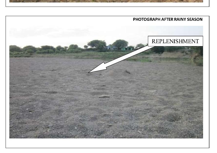
15 Month and velocity of flow is 0.1 to 0.6 m/s and results in settling of fine sediment which is suitable for construction. This in turn causes the development of good sand mining locations. As this river is seasonal only monsoon period (june-sept) is considered for study. During monsoon period the velocity of flow is observed high and is around 0.6m/s. Thus assumption is made that 70% of sand transported is deposited during monsoon period. The rate of deposition is calculated based on this by assuming a width of 200 m from which sand removal takes place daily during the monsoon period. To maintain equilibrium of the river the amount of sand extracted should be less than the amount of sand deposited. Estimation of sand deposition sediment inflow Sand deposition sediment load/day sediment load/month sediment load/month qs(kg/m/hr) (kg/m/hr) qs'=qs*24*width (tonnes) jun jul aug sep Annual sediment load Fig. Map showing different cross-section of river. Conclusion As the demand of sand is increasing it is recommended to remove sand from the blocks as per the proposed sediment load. The sediment deposition in that area is more than the proposed load for removal. The sediment load for the Parbati and Kalisindh River is higher than the proposed excavation of sand. So the removal of that amount of sand will not degrade the health of the river. Shri Pramod Meena 14
Sedimentation in the Nile River
 Advanced Training Workshop on Reservoir Sedimentation Sedimentation in the Nile River Prof. Dr. Abdalla Abdelsalam Ahmed 10-16 Oct. 2007, IRTCES, Beijing, China CWR,Sudan 1 Water is essential for mankind
Do you think sediment transport is a concern?
 STREAM RESTORATION FRAMEWORK AND SEDIMENT TRANSPORT BASICS Pete Klingeman 1 What is Your Restoration Project Like? k? Do you think sediment transport is a concern? East Fork Lewis River, WA Tidal creek,
Strategies for managing sediment in dams. Iwona Conlan Consultant to IKMP, MRCS
 Strategies for managing sediment in dams Iwona Conlan Consultant to IKMP, MRCS 1 Sediment trapping by dams Active storage capacity Dead storage coarse material (bed load) Fine materials (suspension) Francis
Stream Geomorphology. Leslie A. Morrissey UVM July 25, 2012
 Stream Geomorphology Leslie A. Morrissey UVM July 25, 2012 What Functions do Healthy Streams Provide? Flood mitigation Water supply Water quality Sediment storage and transport Habitat Recreation Transportation
Flash flood disaster in Bayangol district, Ulaanbaatar
 Flash flood disaster in Bayangol district, Ulaanbaatar Advanced Training Workshop on Reservoir Sedimentation Management 10-16 October 2007. IRTCES, Beijing China Janchivdorj.L, Institute of Geoecology,MAS
SCOPE OF PRESENTATION STREAM DYNAMICS, CHANNEL RESTORATION PLANS, & SEDIMENT TRANSPORT ANALYSES IN RELATION TO RESTORATION PLANS
 DESIGN METHODS B: SEDIMENT TRANSPORT PROCESSES FOR STREAM RESTORATION DESIGN PETER KLINGEMAN OREGON STATE UNIVERSITY CIVIL ENGINEERING DEPT., CORVALLIS 2 ND ANNUAL NORTHWEST STREAM RESTORATION DESIGN SYMPOSIUM
Earth Science Chapter 6 Section 2 Review
 Name: Class: Date: Earth Science Chapter 6 Section Review Multiple Choice Identify the choice that best completes the statement or answers the question. 1. Most streams carry the largest part of their
FOREST RESEARCH INSTITUTE, DEHRADUN
 PROJECT REPORT DRAINAGE AND REPLENISHMENT STUDY OF MINED AREA OF GANGA SHYAMPUR RIVER HARIDWAR Submitted to UTTARAKHAND FOREST DEVELOPMENT CORPORATION (UFDC) 73, Nehru Road, Deharadun Prepared&Submitted
MATHEMATICAL MODELING OF FLUVIAL SEDIMENT DELIVERY, NEKA RIVER, IRAN. S.E. Kermani H. Golmaee M.Z. Ahmadi
 JOURNAL OF ENVIRONMENTAL HYDROLOGY The Electronic Journal of the International Association for Environmental Hydrology On the World Wide Web at http://www.hydroweb.com VOLUME 16 2008 MATHEMATICAL MODELING
National Hydrology committee of Afghanistan (NHCA) Sedimentation in Reservoire
 Sedimentation in Reservoire") National Hydrology committee of Afghanistan (NHCA) Sedimentation in Reservoire OCt.2007 Prof. Mohammad Qasem Seddeqy KPU بسم االله الرحمن الرحيم وجعلنامن الماءکل شي ء حی 30 واز ا ب هر چيزی رازنده گردانيدیم
National Hydrology committee of Afghanistan (NHCA) Sedimentation in Reservoire OCt.2007 Prof. Mohammad Qasem Seddeqy KPU بسم االله الرحمن الرحيم وجعلنامن الماءکل شي ء حی 30 واز ا ب هر چيزی رازنده گردانيدیم
Module 4: Overview of the Fundamentals of Runoff and Erosion
 Module 4: Overview of the Fundamentals of Runoff and Erosion Module 4a Goal Once we can better understand the forces which cause erosion and runoff, only then can we begin to minimize the negative results.
Solutions to Flooding on Pescadero Creek Road
 Hydrology Hydraulics Geomorphology Design Field Services Photo courtesy Half Moon Bay Review Solutions to Flooding on Pescadero Creek Road Prepared for: San Mateo County Resource Conservation District
New Approaches to Restoring NH s Rivers Natural Channel Design and Dam Removal
 NHACC Annual Meeting 2012 New Approaches to Restoring NH s Rivers Natural Channel Design and Dam Removal Peter J. Walker CROOKED STREAMS are a menace to life and crops in the areas bordering on their banks.
GOVERNMENT OF MADHYA PRADESH WATER RESOURCES DEPARTMENT HANOTA MAJOR PROJECT PRE FEASIBILITY REPORT. ESTIMATED COST : Rs
 GOVERNMENT OF MADHYA PRADESH WATER RESOURCES DEPARTMENT HANOTA MAJOR PROJECT PRE FEASIBILITY REPORT ESTIMATED COST : Rs. 1392.42 Crores DESIGNED IRRIGATION : 40000 Ha. COST PER HACT. : Rs. 3.48 Lakhs ''EVERY
24.0 Mineral Extraction
 Chapter 24 - Mineral Extraction 24.0 Mineral Extraction 24.1 Introduction Apart from gravel, sand, rock, limestone and salt extraction in relatively small quantities mineral extraction is not a strong
Estimation of Bed Load Transport in River Omi, South Western Nigeria using Grain Size Distribution Data
 International Journal of Engineering and Technology Volume 2 No. 9, September, 2012 Estimation of Bed Load Transport in River Omi, South Western Nigeria using Grain Size Distribution Data A.A. Adegbola
Aquifer an underground zone or layer of sand, gravel, or porous rock that is saturated with water.
 Aggradation raising of the streambed by deposition that occurs when the energy of the water flowing through a stream reach is insufficient to transport sediment conveyed from upstream. Alluvium a general
Appendix O. Sediment Transport Modelling Technical Memorandum
 Appendix O Sediment Transport Modelling Technical Memorandum w w w. b a i r d. c o m Baird o c e a n s engineering l a k e s design r i v e r s science w a t e r s h e d s construction Final Report Don
Four Mile Run Levee Corridor Stream Restoration
 Four Mile Run Levee Corridor Stream Restoration 30% Design Summary U.S. Army Corps of Engineers, Baltimore District Presentation Outline Four Mile Run 1.) Historic Perspective 2.) Existing Conditions 3.)
ES 105 Surface Processes I. Hydrologic cycle A. Distribution % in oceans 2. >3% surface water a. +99% surface water in glaciers b.
 ES 105 Surface Processes I. Hydrologic cycle A. Distribution 1. +97% in oceans 2. >3% surface water a. +99% surface water in glaciers b. >1/3% liquid, fresh water in streams and lakes~1/10,000 of water
Analysis of Sedimentation in Wonogiri Reservoir
 Journal of the Civil Engineering Forum Vol. 2 No. 1 (January 2016) Analysis of Sedimentation in Wonogiri Reservoir Tri Joko Inti Budi Santosa Large River Basin Organization of Bengawan Solo, Surakarta,
Technical Review of Pak Beng Hydropower Project (1) Hydrology & Hydraulics and (2) Sediment Transport & River Morphology
 Hydrology & Hydraulics and (2) Sediment Transport & River Morphology") Technical Review of Pak Beng Hydropower Project (1) Hydrology & Hydraulics and (2) Sediment Transport & River Morphology The 2 nd Regional Stakeholder Forum The Pak Beng Hydropower Project 5 th May 2017
Technical Review of Pak Beng Hydropower Project (1) Hydrology & Hydraulics and (2) Sediment Transport & River Morphology The 2 nd Regional Stakeholder Forum The Pak Beng Hydropower Project 5 th May 2017
LAB-SCALE INVESTIGATION ONBAR FORMATION COORDINATES IN RIVER BASED ON FLOW AND SEDIMENT
 LAB-SCALE INVESTIGATION ONBAR FORMATION COORDINATES IN RIVER BASED ON FLOW AND SEDIMENT Mat Salleh M. Z., Ariffin J., Mohd-Noor M. F. and Yusof N. A. U. Faculty of Civil Engineering, University Technology
STUDY GUIDE FOR CONTENT MASTERY. Surface Water Movement
 Surface Water SECTION 9.1 Surface Water Movement In your textbook, read about surface water and the way in which it moves sediment. Complete each statement. 1. An excessive amount of water flowing downslope
Stream Restoration and Environmental River Mechanics. Objectives. Pierre Y. Julien. 1. Peligre Dam in Haiti (deforestation)
") Stream Restoration and Environmental River Mechanics Pierre Y. Julien Malaysia 2004 Objectives Brief overview of environmental river mechanics and stream restoration: 1. Typical problems in environmental
Stream Restoration and Environmental River Mechanics Pierre Y. Julien Malaysia 2004 Objectives Brief overview of environmental river mechanics and stream restoration: 1. Typical problems in environmental
River floodplain regime and stratigraphy. Drs. Nanette C. Kingma.
 River floodplain regime and stratigraphy. Drs. Nanette C. Kingma. Formation of floodplain. Formation of floodplains: lateral channel migration in channel deposition suspended-load fall out during higher
Dolores River Watershed Study
 CHAPTER 4: RIVER AND FLOODPLAIN ISSUES The Dolores River falls into a category of streams in Colorado that share some unique characteristics. Like some other mountain streams in the state, it has a steep
Dam Removal Analysis Guidelines for Sediment
 A review of: Dam Removal Analysis Guidelines for Sediment Joe Rathbun (Retired) rathbunj@sbcglobal.net Some Potential Sediment Issues Reservoir restoration Downstream water quality Downstream deposition
Upper Truckee River Restoration Lake Tahoe, California Presented by Brendan Belby Sacramento, California
 Upper Truckee River Restoration Lake Tahoe, California Presented by Brendan Belby Sacramento, California Mike Rudd (Project Manager), Charley Miller & Chad Krofta Declines in Tahoe s Water Clarity The
CASE STUDY BINGA, PHILIPPINES
 SEDIMENT MANAGEMENT CASE STUDY BINGA, PHILIPPINES Key project features Name: Binga Country: Philippines Category: modify operating rule (focus or redistribute sediment); adaptive strategies Binga hydropower
Tarbela Dam in Pakistan. Case study of reservoir sedimentation
 Tarbela Dam in Pakistan. HR Wallingford, Wallingford, UK Published in the proceedings of River Flow 2012, 5-7 September 2012 Abstract Reservoir sedimentation is a main concern in the Tarbela reservoir
Working with Natural Stream Systems
 Working with Natural Stream Systems Graydon Dutcher Delaware County Soil & Water Conservation District Stream Corridor Management Program Tropical Storm Sandy October 29,2012 What is a Watershed?
INTERNATIONAL JOURNAL OF PURE AND APPLIED RESEARCH IN ENGINEERING AND TECHNOLOGY
 INTERNATIONAL JOURNAL OF PURE AND APPLIED RESEARCH IN ENGINEERING AND TECHNOLOGY A PATH FOR HORIZING YOUR INNOVATIVE WORK ASSESSMENT OF RESERVOIR SEDIMENTATION IN PANSHET RESERVOIR BY HYBRID METHOD N.
In-channel coarse sediment trap Best Management Practice
 In-channel coarse sediment trap Best Management Practice By Henry R. Hudson July 2002 Environmental Management Associates Ltd., Christchurch Complexity Environmental Value Cost Low Moderate High Low Moderate
WATERCOURSE HARNESSING BANK EROSION AND CONSOLIDATION
 GUVERNUL MINISTERUL POSDRU MUNCII, FAMILIEI ŞI WATERCOURSE HARNESSING BANK EROSION AND CONSOLIDATION PhD. student: ALUPOAE Daniel Gheorghe Asachi Technical University of Iasi, Faculty of Civil Engineering
Surface Water and Stream Development
 Surface Water and Stream Development Surface Water The moment a raindrop falls to earth it begins its return to the sea. Once water reaches Earth s surface it may evaporate back into the atmosphere, soak
Assignment 1. Measuring River Characteristics- Vernon Creek. Applied Fluvial Geomorphology Field Techniques EESc 435
 Assignment 1 Measuring River Characteristics- Vernon Creek Applied Fluvial Geomorphology Field Techniques EESc 435 Amanda Jardine 30100093 Jaime McDonald 14177083 Erica Massey 50870088 April 28, 2012 Introduction
Geomorphology. considerations
 Environmental Flows Geomorphology considerations Dr Beevers, Heriot Watt University: Dr A Crosato UNESCO IHE Hydraulics Summary Water components important for ecology etc (depth, velocity, innundation
Chapter-3 GEOGRAPHICAL LOCATION, CLIMATE AND SOIL CHARACTERISTICS OF THE STUDY SITE
 Chapter-3 GEOGRAPHICAL LOCATION, CLIMATE AND SOIL CHARACTERISTICS OF THE STUDY SITE Chapter-3 GEOGRAPHICAL LOCATION, CLIMATE AND SOIL CHARACTERISTICS OF THE STUDY SITE Assam, the eastern most state of
Study of Hydrometeorology in a Hard Rock Terrain, Kadirischist Belt Area, Anantapur District, Andhra Pradesh
 Open Journal of Geology, 2012, 2, 294-300 http://dx.doi.org/10.4236/ojg.2012.24028 Published Online October 2012 (http://www.scirp.org/journal/ojg) Study of Hydrometeorology in a Hard Rock Terrain, Kadirischist
Diagnostic Geomorphic Methods for Understanding Future Behavior of Lake Superior Streams What Have We Learned in Two Decades?
 Diagnostic Geomorphic Methods for Understanding Future Behavior of Lake Superior Streams What Have We Learned in Two Decades? Faith Fitzpatrick USGS WI Water Science Center, Middleton, WI fafitzpa@usgs.gov
7.3 Sediment Delivery Analysis
 7.3 Sediment Delivery Analysis In order to evaluate potential changes in sedimentation patterns that could occur due to impacts from the FCP and LPP alignments, sediment assessment models were constructed
U.S. Army Corps of Engineers Detroit District. Sediment Trap Assessment Saginaw River, Michigan
 U.S. Army Corps of Engineers Detroit District December 2001 December 2001 This report has been prepared for USACE, Detroit District by: W.F. BAIRD & ASSOCIATES LTD. 2981 YARMOUTH GREENWAY MADISON, WISCONSIN
Stream geomorphology mapping
 The effects of deforestation on tropical freshwater streams: A comparison of stream geomorphology and coarser clastic particles distribution between Kasekera watershed (forested) and Mtanga watershed (deforested),
EFFECT OF SAND MINING ACTIVITY ON THE SEDIMENT CONTROL SYSTEM (A CASE STUDY OF SOMBE-LEWARA RIVER, DONGGALA, INDONESIA)
") Civil Engineering Forum Volume XXI/1 - January 01 EFFECT OF SAND MINING ACTIVITY ON THE SEDIMENT CONTROL SYSTEM (A CASE STUDY OF SOMBE-LEWARA RIVER, DONGGALA, INDONESIA) Y. A. Bawias Agency of Public Works,
Civil Engineering Forum Volume XXI/1 - January 01 EFFECT OF SAND MINING ACTIVITY ON THE SEDIMENT CONTROL SYSTEM (A CASE STUDY OF SOMBE-LEWARA RIVER, DONGGALA, INDONESIA) Y. A. Bawias Agency of Public Works,
CLIMATE RESILIENT ALTITUDINAL GRADIENTS (CRAGs)
") CLIMATE RESILIENT ALTITUDINAL GRADIENTS (CRAGs) BUILDING CLIMATE CHANGE RESILIENCE IN THE KIVU- RUSIZI WATERSHEDS Great Lake Conference Entebbe 2017 Chris Magero WHAT ARE CRAGs? Climate-Resilient Altitudinal
CLIMATE RESILIENT ALTITUDINAL GRADIENTS (CRAGs) BUILDING CLIMATE CHANGE RESILIENCE IN THE KIVU- RUSIZI WATERSHEDS Great Lake Conference Entebbe 2017 Chris Magero WHAT ARE CRAGs? Climate-Resilient Altitudinal
CASE STUDY BINGA, PHILIPPINES
 SEDIMENT MANAGEMENT CASE STUDY BINGA, PHILIPPINES Key project features Name: Binga Country: Philippines Category: modify operating rule (focus or redistribute sediment); adaptive strategies Reservoir volume
Landscape Development
 Landscape Development Slopes Dominate Natural Landscapes Created by the interplay of tectonic and igneous activity and gradation Deformation and uplift Volcanic activity Agents of gradation Mass wasting
Environmental impact assessment study of the new offshore dumping sites for Šventoji port in Lithuania
 Environmental impact assessment study of the new offshore dumping sites for Šventoji port in Lithuania Introduction Summary In 2003 Lithuanian Ministry of Transport initiated the preparation of feasibility
FUTURE MEANDER BEND MIGRATION AND FLOODPLAIN DEVELOPMENT PATTERNS NEAR RIVER MILES 200 TO 191 OF THE SACRAMENTO RIVER PHASE III REPORT
 FUTURE MEANDER BEND MIGRATION AND FLOODPLAIN DEVELOPMENT PATTERNS NEAR RIVER MILES 200 TO 191 OF THE SACRAMENTO RIVER PHASE III REPORT Eric W. Larsen REPORT FOR DUCKS UNLIMITED March 31, 2006-1 - Contents
Report for Area Drainage Studies for 1320 MW (2x660 MW) THERMAL POWER PROJECT AT MIRZAPUR, U.P.
 THERMAL POWER PROJECT AT MIRZAPUR, U.P.") Report for Area Drainage Studies for 1320 MW (2x660 MW) THERMAL POWER PROJECT AT MIRZAPUR, U.P. 1. Introduction M/s Welspun Energy Uttar Pradesh Ltd. (WEUPL) is putting up 1320 MW (2 x 660 MW) coal fired
Report for Area Drainage Studies for 1320 MW (2x660 MW) THERMAL POWER PROJECT AT MIRZAPUR, U.P. 1. Introduction M/s Welspun Energy Uttar Pradesh Ltd. (WEUPL) is putting up 1320 MW (2 x 660 MW) coal fired
SPECIFIC DEGRADATION AND RESERVOIR SEDIMENTATION. By Renee Vandermause & Chun-Yao Yang
 SPECIFIC DEGRADATION AND RESERVOIR SEDIMENTATION By Renee Vandermause & Chun-Yao Yang Outline Sediment Degradation - Erosion vs Sediment Yield - Sediment Yield - Methods for estimation - Defining Sediment
Appendix K.2: Sediment Management Excerpt from South Orange County Hydromodification Management Plan
 Appendix K.2: Sediment Management Excerpt from South Orange County Hydromodification Management Plan 4 Sediment Supply Management Requirements Permit Order R9-2013-0001 as amended by Order No. R9-2015-0001Section
Influence of the Major Drainages to the Mississippi River and Implications for System Level Management
 Influence of the Major Drainages to the Mississippi River and Implications for System Level Management Brian M. Vosburg Geologist Louisiana Coastal Protection and Restoration Authority brian.vosburg@la.gov
Step 5: Channel Bed and Planform Changes
 Step 5: Channel Bed and Planform Changes When disturbed, streams go through a series of adjustments to regain equilibrium with the flow and sediment supply of their watersheds. These adjustments often
BZ471, Steam Biology & Ecology Exam 1
 BZ471, Exam1, p.1 BZ471, Steam Biology & Ecology Exam 1 Name Matching. Select the single best (most precise) answer for each of the following. Use each answer no more than once. No partial credit is given.
3/3/2013. The hydro cycle water returns from the sea. All "toilet to tap." Introduction to Environmental Geology, 5e
 Introduction to Environmental Geology, 5e Running Water: summary in haiku form Edward A. Keller Chapter 9 Rivers and Flooding Lecture Presentation prepared by X. Mara Chen, Salisbury University The hydro
Surface Processes Focus on Mass Wasting (Chapter 10)
") Surface Processes Focus on Mass Wasting (Chapter 10) 1. What is the distinction between weathering, mass wasting, and erosion? 2. What is the controlling force in mass wasting? What force provides resistance?
Surface Processes Focus on Mass Wasting (Chapter 10) 1. What is the distinction between weathering, mass wasting, and erosion? 2. What is the controlling force in mass wasting? What force provides resistance?
Mississippi River and Tributaries Project Mississippi River Geomorphology and Potamology Program
 Mississippi River and Tributaries Project Mississippi River Geomorphology and Potamology Program Barb Kleiss, Mississippi Valley Division Freddie Pinkard, Vicksburg District June, 2016 Program Objectives
Environmental Implications A Case Study
 Grain Size Variations and Its Environmental Implications A Case Study DR PURANDARA BEKAL SCIENTIST, NATIONAL INSTITUTE OF HYDROLOGY HARD ROCK REGIONAL CENTER HANUMAN NAGAR BELGAUM, KARNATAKA Particle Transport
The effectiveness of check dams in controlling upstream channel stability in northeastern Taiwan
 Erosion, Debris Mows and Environment in Mountain Regions (Proceedings of the Chengdu Symposium, July 1992). IAHS Publ. no. 209, 1992. 423 The effectiveness of check dams in controlling upstream channel
B-1. Attachment B-1. Evaluation of AdH Model Simplifications in Conowingo Reservoir Sediment Transport Modeling
 Attachment B-1 Evaluation of AdH Model Simplifications in Conowingo Reservoir Sediment Transport Modeling 1 October 2012 Lower Susquehanna River Watershed Assessment Evaluation of AdH Model Simplifications
Sediment Distribution and Characteristics
 Sediment Distribution and Characteristics Sediments at the bottom of ponds are a source or sink for nutrients in relation to the water column, contribute to turbidity during storm events, serve as the
mountain rivers fixed channel boundaries (bedrock banks and bed) high transport capacity low storage input output
 high transport capacity low storage input output") mountain rivers fixed channel boundaries (bedrock banks and bed) high transport capacity low storage input output strong interaction between streams & hillslopes Sediment Budgets for Mountain Rivers Little
mountain rivers fixed channel boundaries (bedrock banks and bed) high transport capacity low storage input output strong interaction between streams & hillslopes Sediment Budgets for Mountain Rivers Little
Teacher s Pack Key Stage 3 GEOGRAPHY
 Teacher s Pack Key Stage 3 GEOGRAPHY Geography Key Stage 3 Fieldwork Worksheet Rivers: 1. Is the water fresh or salty? (test its resistance or specific gravity) 2. Do you know where the water is coming
Rivers T. Perron
 1 Rivers T. Perron 12.001 After our discussions of large-scale topography, how we represent topography in maps, and how topography interacts with geologic structures, you should be frothing at the mouth
Griswold Creek August 22, 2013
 Creek August 22, 2013 1 Lake Erie Protection Fund Creek Study ver Evaluate the overall condition of Creek Determine stable channel dimensions & appropriate restoration techniques Starting Stat gpoint for
International Journal for Management Science And Technology (IJMST)
") ISSN: 2320-8848 (Online) ISSN: 2321-0362 (Print) International Journal for Management Science And Technology (IJMST) Volume 3; Issue 6 Manuscript- 1 SUSPENDED SEDIMENT TRANSPORT FORMULA FOR THE UPSTREAM
ISSN: 2320-8848 (Online) ISSN: 2321-0362 (Print) International Journal for Management Science And Technology (IJMST) Volume 3; Issue 6 Manuscript- 1 SUSPENDED SEDIMENT TRANSPORT FORMULA FOR THE UPSTREAM
Technical Memorandum No
 Pajaro River Watershed Study in association with Technical Memorandum No. 1.2.10 Task: Evaluation of Four Watershed Conditions - Sediment To: PRWFPA Staff Working Group Prepared by: Gregory Morris and
Why Geomorphology for Fish Passage
 Channel Morphology - Stream Crossing Interactions An Overview Michael Love Michael Love & Associates mlove@h2odesigns.com (707) 476-8938 Why Geomorphology for Fish Passage 1. Understand the Scale of the
SECTION G SEDIMENT BUDGET
 SECTION G SEDIMENT BUDGET INTRODUCTION A sediment budget has been constructed for the for the time period 1952-2000. The purpose of the sediment budget is to determine the relative importance of different
Swift Creek Sediment Management Action Plan (SCSMAP)
") Swift Creek Sediment Management Action Plan (SCSMAP) PHASE 2 PROJECT PLAN PROPOSAL Whatcom County Public Works Department 322 N. Commercial Street, Suite 210 Bellingham, WA 98225 (360) 676-6692 June 2013
Swift Creek Sediment Management Action Plan (SCSMAP) PHASE 2 PROJECT PLAN PROPOSAL Whatcom County Public Works Department 322 N. Commercial Street, Suite 210 Bellingham, WA 98225 (360) 676-6692 June 2013
Ecoregions Glossary. 7.8B: Changes To Texas Land Earth and Space
 Ecoregions Glossary Ecoregions The term ecoregions was developed by combining the terms ecology and region. Ecology is the study of the interrelationship of organisms and their environments. The term,
In the space provided, write the letter of the description that best matches the term or phrase. a. any form of water that falls to Earth s
 Skills Worksheet Concept Review In the space provided, write the letter of the description that best matches the term or phrase. 1. condensation 2. floodplain 3. watershed 4. tributary 5. evapotranspiration
N07/3/GEOGR/HP2/ENG/TZ0/XX/Q+ Geography Higher level. Tuesday 13 November 2007 (morning) 2 hours 30 minutes
 2 hours 30 minutes") IB Geography Higher level PAPER 2 DIPLOMA PROGRAMME PROGRAMME DU DIPLÔME DU BI PROGRAMA DEL DIPLOMA DEL BI N07/3/GEOGR/HP2/ENG/TZ0/XX/Q+ 88075202 Tuesday 13 November 2007 (morning) 2 hours 30 minutes instructions
IB Geography Higher level PAPER 2 DIPLOMA PROGRAMME PROGRAMME DU DIPLÔME DU BI PROGRAMA DEL DIPLOMA DEL BI N07/3/GEOGR/HP2/ENG/TZ0/XX/Q+ 88075202 Tuesday 13 November 2007 (morning) 2 hours 30 minutes instructions
Suspended sediment yields of rivers in Turkey
 Erosion and Sediment Yield: Global and Regional Perspectives (Proceedings of the Exeter Symposium, July 1996). IAHS Publ. no. 236, 1996. 65 Suspended sediment yields of rivers in Turkey FAZLI OZTURK Department
River Response. Sediment Water Wood. Confinement. Bank material. Channel morphology. Valley slope. Riparian vegetation.
 River Response River Response Sediment Water Wood Confinement Valley slope Channel morphology Bank material Flow obstructions Riparian vegetation climate catchment vegetation hydrological regime channel
Erosion Surface Water. moving, transporting, and depositing sediment.
 + Erosion Surface Water moving, transporting, and depositing sediment. + Surface Water 2 Water from rainfall can hit Earth s surface and do a number of things: Slowly soak into the ground: Infiltration
River Restoration and Rehabilitation. Pierre Y. Julien
 River Restoration and Rehabilitation Pierre Y. Julien Department of Civil and Environmental Engineering Colorado State University Fort Collins, Colorado River Mechanics and Sediment Transport Lima Peru
STREAM SYSTEMS and FLOODS
 STREAM SYSTEMS and FLOODS The Hydrologic Cycle Precipitation Evaporation Infiltration Runoff Transpiration Earth s Water and the Hydrologic Cycle The Hydrologic Cycle The Hydrologic Cycle Oceans not filling
Precipitation Evaporation Infiltration Earth s Water and the Hydrologic Cycle. Runoff Transpiration
 STREAM SYSTEMS and FLOODS The Hydrologic Cycle Precipitation Evaporation Infiltration Earth s Water and the Hydrologic Cycle Runoff Transpiration The Hydrologic Cycle The Hydrologic Cycle Oceans not filling
PEACOCK D H LIMITED MAKARIKA STREAM MEAN BED LEVEL TRENDS; 1958 TO 2017.
 PEACOCK D H LIMITED GST Reg No 97918708 email: dave2mar@gmail.com Mob: 021 02465899 1.0 Introduction: MAKARIKA STREAM MEAN BED LEVEL TRENDS; 1958 TO 2017. This is one of a series of reports on river bed
Flood Inundation Mapping under different climate change scenarios in the upper Indus River Basin, Pakistan
 Flood Inundation Mapping under different climate change scenarios in the upper Indus River Basin, Pakistan Sohaib Baig (doctoral student) 16 November 2017 Disaster Prevention Research Institute 1 Kyoto
6.11 Naas River Management Unit
 6.11 Naas River Management Unit 6.11.1 Site 41 Issue: Bed and bank erosion Location: E 0685848 N 6058358 Waterway: Naas River Management Unit: Naas River Facing downstream from Bobeyan Rd bridge Facing
Figure 2.1: Constituent Area
 2 The Region 2.1 CONSTITUENT AREA The National Capital Region includes NCT-Delhi, nine districts of Haryana, six districts of Uttar Pradesh and one district of Rajasthan. Total area of the region is 34,144
Chapter 11. Rivers: Shaping our landscape
 Chapter 11 Rivers: Shaping our landscape Learning outcomes In this presentation you will learn: Common terms associated with rivers About the three stages of a river About the processes of river erosion
Upper Drac River restoration project
 Upper Drac River restoration project Restoration of a braided river bed incised in clay substratum through sediment reloading and bed widening SHF Conference, Nantes, 6 & 7 october 2014 Small scale morphological
 1.3.1.1 Incipient Motion Particle movement will occur when the instantaneous fluid force on a particle is just larger than the instantaneous resisting force related to the submerged particle weight and
AP ENVIRONMENTAL SCIENCE 2013 SCORING GUIDELINES [14 pt space] Question 1
![AP ENVIRONMENTAL SCIENCE 2013 SCORING GUIDELINES [14 pt space] Question 1](/thumbs/77/74883235.jpg "AP ENVIRONMENTAL SCIENCE 2013 SCORING GUIDELINES [14 pt space] Question 1") AP ENVIRONMENTAL SCIENCE 2013 SCORING GUIDELINES [14 pt space] Question 1 (a) Identify TWO human activities that alter the natural flow of sediments into Gulf Coast ecosystems. Explain how each of the
AP ENVIRONMENTAL SCIENCE 2013 SCORING GUIDELINES [14 pt space] Question 1 (a) Identify TWO human activities that alter the natural flow of sediments into Gulf Coast ecosystems. Explain how each of the
SPACING OF RURAL SETTLEMENTS IN NAGAUR DISTRICT, RAJASTHAN: A SPATIAL ANALYSIS
 Journal of Global Resources Volume 5 July 2017 Page 28-33 ISSN: 2395-3160 (Print), 2455-2445 (Online) 05 SPACING OF RURAL SETTLEMENTS IN NAGAUR DISTRICT, RAJASTHAN: A SPATIAL ANALYSIS Varun Binda Assistant
Opportunities to Improve Ecological Functions of Floodplains and Reduce Flood Risk along Major Rivers in the Puget Sound Basin
 Opportunities to Improve Ecological Functions of Floodplains and Reduce Flood Risk along Major Rivers in the Puget Sound Basin Christopher Konrad, US Geological Survey Tim Beechie, NOAA Fisheries Managing
Catastrophic Events Impact on Ecosystems
 Catastrophic Events Impact on Ecosystems Hurricanes Hurricanes An intense, rotating oceanic weather system with sustained winds of at least 74 mph and a welldefined eye Conditions for formation: Warm water
Bank Erosion and Morphology of the Kaskaskia River
 Bank Erosion and Morphology of the Kaskaskia River US Army Corps Of Engineers St. Louis District Fayette County Soil and Water Conservation District Team Partners : Carlyle Lake Ecosystem Partnership Vicinity
Dawood Public School Secondary Section Class VII
 Dawood Public School Secondary Section Class VII Introduction: Geography is the study of the Earth and its lands, features, inhabitants, and phenomena relating to the sciences of aforementioned. This subject
Summary. Streams and Drainage Systems
 Streams and Drainage Systems Summary Streams are part of the hydrologic cycle and the chief means by which water returns from the land to the sea. They help shape the Earth s surface and transport sediment
Tom Ballestero University of New Hampshire. 1 May 2013
 Tom Ballestero University of New Hampshire 1 May 2013 1 Hydrology 2 Basic Hydrology Low flows most common Flows that fill the stream to the banks and higher are much less common Filling the stream to the
Black Gore Creek 2013 Sediment Source Monitoring and TMDL Sediment Budget
 Black Gore Creek 2013 Sediment Source Monitoring and TMDL Sediment Budget Prepared for: Prepared By: - I. Introduction The Black Gore Creek Total Maximum Daily Load (TMDL) was developed in collaboration
Introduction Fluvial Processes in Small Southeastern Watersheds
 Introduction Fluvial Processes in Small Southeastern Watersheds L. Allan James Scott A. Lecce Lisa Davis Southeastern Geographer, Volume 50, Number 4, Winter 2010, pp. 393-396 (Article) Published by The
6.1 Water. The Water Cycle
 6.1 Water The Water Cycle Water constantly moves among the oceans, the atmosphere, the solid Earth, and the biosphere. This unending circulation of Earth s water supply is the water cycle. The Water Cycle
FOR Sand Stone Quarry Village : Chhirraleva Tehsil : Basna District : Mahasamund
 Project Report FOR Sand Stone Quarry at Village : Chhirraleva Tehsil : Basna District : Mahasamund Contents 1. About the Firm... 1 2. Location of the Project... 1 3. Environmental Setting of Project...