Sensor Web Approach for Earthquake studies. D. Ouzounov
|
|
|
- Noel Murphy
- 5 years ago
- Views:
Transcription

1 1 Application of Remote Sensing Technologies for Disaster Risk Management: Mutisensor approach of analyzing atmospheric signals and search for possible earthquake precursors D. Ouzounov 1,4, S. Habib 2, and S. Ambrose3 1NASA Goddard Space Flight Center/SSAI, MS 610 Greenbelt, MD 20177, United States Goddard Space Flight Center, Science & Exploration Directorate, MS 604, MD 20177, United States 3NASA Headquarters, Applied Sciences Program, Disaster Management Program, Washington, DC 20546, United States 4Chapman University, United States 2NASA Sensor Web Approach for Earthquake studies TIR anomaly prior to Sumatra, Dec 26,2004 (Ouzounov,2007)
2 1 Application of Remote Sensing Technologies for Disaster Risk Management: Mutisensor approach of analyzing atmospheric signals and search for possible earthquake precursors D. Ouzounov 1,4, S. Habib 2, and S. Ambrose 3 1 NASA Goddard Space Flight Center/SSAI, MS 610 Greenbelt, MD 20177, United States 2 NASA Goddard Space Flight Center, Science & Exploration Directorate, MS 604, MD 20177, United States 3 NASA Headquarters, Applied Sciences Program, Disaster Management Program, Washington, DC 20546, United States 4 Chapman University, United States NASA - P.Taylor, F.Policelli, N. Bryant, NASA JPL/Caltech GMU -G.Cervone, M.Kafatos S. Pulinets, IZMIRAN, Russia M.Parrot, DEMETER,CNES, France S.Uyeda,K. Hattori, Chiba University, Japan V.Tramutoli, University of Basilicata, Italy G.Ciarlo, CNRS, Florence, Italy X. Shen, Chen I-wan,China Earthquake Administration, China J.Y.Liu, H-C. Wu, National central University, Taiwan Turkey, Greece, Israel Dimitar.P.Ouzounov@nasa.gov
3 Outline Background Early earthquake warning systems LAIC model and validation Sensor Web Approach Validation Hind casting and real alerts May 12th, M7.8 Sichuan earthquake, China Summary
4 Overview Multisensor approach for tracking earthquake atmospheric signals This study is on early stage of validation. The purpose of this study is to utilize global remote-sensing satellite data (thermal infrared observations from Terra, Aqua, GOES, POES, METEOSAT, space plasma parameters from DEMETER,DMSP and COSMIC), simultaneously with ground observations to detect and understand atmospherics signals prior to major earthquakes. Our approach is integrated analysis (Sensor Web) of satellite and ground measurements. Our main goal to establish a historical multi-year (10-20 years) time series baseline by continuous monitoring of the multi atmospheric and ionospheric signals (precursors) over different seismo-tectonic background.
5 The Grand Challenges for Disaster Reduction Provide hazard and disaster information where and when it is needed. Understand the natural processes that produce hazards. Develop hazard mitigation strategies and technologies. Recognize and reduce vulnerability of interdependent critical infrastructure. Assess disaster resilience using standard methods. Promote risk-wise behavior.


6 Implementing the Grand Challenges Fully explore the predictability of earthquakes based on testable and credible methods, and provide objective reviews of predictions..


7 Do we have a choice? Earthquake/Tsunami Occurrence of Floods Contaminated Fresh Water Supply Spread of Multiple Infectious Diseases Volcanic Eruption Aerosol and Dust deposition and suspension Agriculture Efficiency Breathing problems Severe Weather Fires Air Quality Public Health Electric Grid Outages Shutdown City Anthropogenic or Technological
8 Outline Background Early earthquake warning systems LAIC model and validation Sensor Web Approach Validation Hind casting and real alerts May 12th, M7.8 Sichuan earthquake, China Summary


9 Source of the Natural Hazards and Early Warning Systems Planning Avalanche Flood Recovery Disaster Management Cycle Mitigation Drought Landslide, Mudflow Forest Fire Volcano Response Severe Storm, Hurricane, Tornado Tsunami Earthquakes?

10 Map of earthquake early-warning systems Map showing the locations of earthquake early-warning systems currently in operation (blue) or development (green) around the world. Operational systems include Japan, Taiwan, Mexico, and Turkey. Systems are in development for California, Egypt, Greece, Iceland, Italy, Romania, and Switzerland. The locations are overlaid on the GSHAP global seismichazard map (Giardini et al., 1999). (After Allen, 2007)

11 NASA Applied Science Architecture for Integrated Solutions
12 Outline Background Early earthquake warning systems LAIC model and validation Sensor Web Approach Validation Hind casting and real alerts May 12th, M7.8 Sichuan earthquake, China Summary
13 Pre-earthquake related signals Planetary positions Ground deformations Geomagnetic methods Energy accumulation rate Earthquake clouds Gravity anomalies Ground water level Radon concentrations Meteorological conditions Thermal infrared Infrasound Crustal stress Abnormal behaviour of animals Geo-electric pulse Historical/statistical data Ground-based EM field Tilt meters GPS TGFR MS-Double Time Method Geo-electricity Micro-vibration Earth resistivity Geochemistry Seismic gap Foreshocks Geodesy Micro-changes Ionosphere Vandergeden(2005)
14 Mechanism of Lithosphere -Atmosphere Ionosphere Coupling (LAIC) Model L-A A-I OLR anomalies Air temperature growth Earthquake clouds formation Electric field effects within the ionosphere Latent heat release Convective ions uplift, charge separation, drift in anomalous EF Atmospheric electric field growth Humidity drop Ions hydration formation of aerosol size particles Air conductivity change Air ionization by α-particles product of radon decay Faults activation permeability changes Gas discharges including radon emanation (Pulinets, 2004, Pulinets, Ouzounov et al, 2006)
15 Alternative models 1. Tectonic heat flow 2. Thermal waters (Gorny,1998) 3. Greenhouse gases (Tronin,2000) 4. Positive holes (Freund,2004) 5. LAIC- Ionization by radon as one of the degassing components (Pulinets,2004 Ouzounov,2006)

16 The annual mean global energy balance of the Earthatmosphere system [Hobbs, 2000]

 = T ref (")
 V ref (r)")

17 What anomaly means? TIR Signal T a ( r,t) = T ref ( r,t' )("/+)# $T ( r) V ref (r) ±ns(r) Time or distance [after Tramutoli, 2004]
18 Outline Background Early earthquake warning systems LAIC model and validation Sensor Web Approach Validation Hind casting and real alerts May 12th, M7.8 Sichuan earthquake, China Summary
19 Traditional Use of Sensors Observation->detection->modeling->monitoring-> forecasting?? Satellite Sensor Application Satellite Sensor Satellite Sensor Ground Sensor Ground Sensor Application
20 A Sensor Web Approach Observation->detection->modeling->monitoring-> forecasting Satellite Sensor Satellite Sensor Satellite Sensor Satellite Sensor Application Numerical Models Data Mining Virtual Sensor Application Application Application Ground Sensor Ground Sensor Ground Sensor Ground Sensor
 Sensors fusion -Space, Ground, Virtual Needed when")
21 What is a Sensor Web? SeWeb a coordinated observation infrastructure employing multiple sensors that are distributed on one or more platforms (Sherwood&Chein,2007) Sensors fusion -Space, Ground, Virtual Needed when Dedicated sensors do not exist Insufficient temporal and spatial resolution 1/ use of multiple and already validated physical measurements to be fused into one framework with the latest theoretical models; 2/ enabling model interactions with sensor webs; 3/ provided a feedback on data gaps that may then be acquired from other sources; 4/ provide advanced data mining algorithms to classify, cluster, and find patterns in the data. Sensormag.com
22 Outline Background Early earthquake warning systems LAIC model and validation Sensor Web Approach Validation Hind casting and real alerts May 12th, M7.8 Sichuan earthquake, China Summary


23 Validation Man-made effects - Chernobyl Methodology validation: Case of Chernobyl nuclear accident Russia, April 1986 a: April, 1986 AVHRR/OLR; b: May 1986
24 Outline Background Early earthquake warning systems LAIC model and validation Sensor Web Approach Validation Hind casting and real alerts May 12th, M7.8 Sichuan earthquake, China Summary
 Global analysis of OLR variability prior to major earthquakes 2001-2005 Name Date M, H,(km) EQ mechanism OLRAnomaly W/m -2 Detection time,days Toll Bhuj, Gujarat India 01/26/2001")
25 Case studies of TIR- earthquake analysis (hind casting mode) 150 M>5.0 (TIR,OLR,GPS/TEC, OLR, SLHF,T/H,DEMETER) & 4,000 M>5.0 earthquakes (SLHF) Global analysis of OLR variability prior to major earthquakes Name Date M, H,(km) EQ mechanism OLRAnomaly W/m -2 Detection time,days Toll Bhuj, Gujarat India 01/26/ Thrust Fault ,000 Southeastern Iran 12/26/ Strike-slip fault ,000 Kashmir Pakistan 10/15/ Strike ,000 Andama.Sumatra, 12/26/ Mega thrust ,000


26 Case studies of earthquake analysis Up to today were analyzed more then 150 M>5.0 (TIR,OLR,GPS/TEC, OLR, SLHF,T/H,DEMETER) Bhuj, India 01/26/2001, M7.9 Anomaly detection Jan, Southeastern Iran 12/26/2003, M6.6 Anomaly detection Dec, Kashmir, Pakistan 10/15/2005 M7.6 Anomaly detection Oct, Andaman Isl. Sumatra 12/26/2004 M9.0 Anomaly detection Dec, Ouzounov et al, 2007
 OLR anomaly [W/m 2 ] 80 40 0-40 -80 Sumatra, Oct-Dec 2004 2004 NOAA-16 OLR 2001-2004 OLR +1 SIGMA mean field M9.")
27 Northern Sumatra Dec 26,2004, M9.0 A/ Map of OLR monthly variations for November 2004, month prior to M9.0 Sumatra Andaman Island, Northern Sumatra of December 26, Epicenter (3.09N/94.26E) OLR anomaly [W/m 2 ] Sumatra, Oct-Dec NOAA-16 OLR OLR +1 SIGMA mean field M9.0 Andaman Island Northern Sumatra, 12/26/ /1 10/6 10/11 10/16 10/21 10/26 10/31 11/5 11/10 11/15 11/20 11/25 11/30 12/5 12/10 12/15 12/20 12/25 12/30 Time, October-December 2004, [days] B/Time-series of daily OLR anomaly for October 1, 2004 December 31, 2004 over the epicenter of (3.09N/ 94.26E)


28 M6.6 Southeastern Iran, Dec Map of OLR monthly variations for November 2003 OLR anommaly [W/m -2 ] Iran, OLR +1 sigma mean 2003 NOAA-15 OLR M6.6 Southeastern Iran of 12/26/ /1/03 10/11/03 10/21/03 10/31/03 11/10/03 11/20/03 11/30/03 12/10/03 12/20/03 12/30/03 1/9/04 Oct 1, Dec, Time-series of daily OLR anomaly for October 1, 2003 December 31, 2003 over the epicenter of (29.1N/ 58.2E)

 NEAR WEST COAST OF HONSHU, JAPAN 37.6 138.")

29 Validation over Japan (forecast mode) Evolution of daily Earth radiation anomalies. Earthquake has occurred :13 (Mw 6.7) NEAR WEST COAST OF HONSHU, JAPAN July 4, 2007 Time evolution: July 4 EQ Alert July 14- EQ Warning July 16- EQ Event July 14, 2007 July 16, 2007, USGS
30 Outline Background Early earthquake warning systems LAIC model and validation Sensor Web Approach Validation Hind casting and real alerts May 12th, M7.8 Sichuan earthquake, China Summary

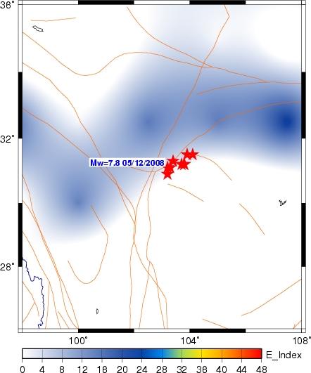
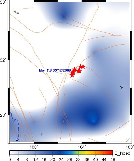
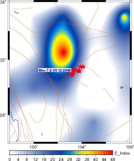
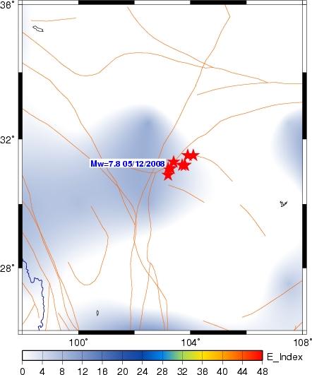
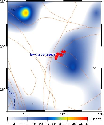
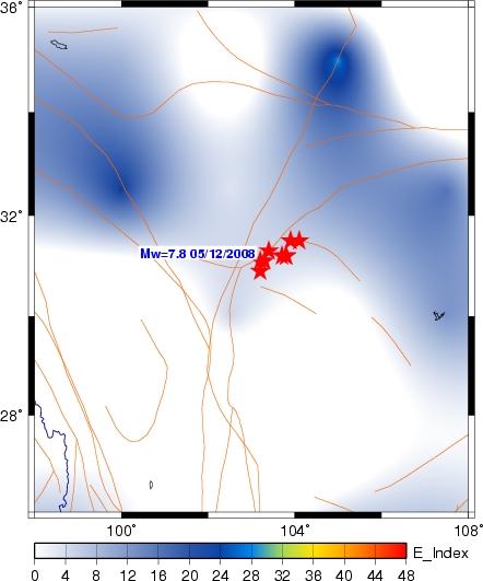
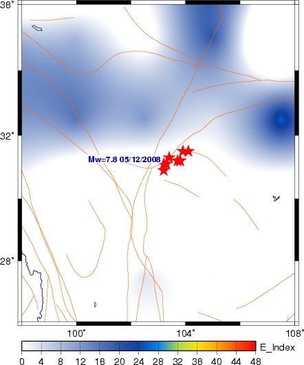
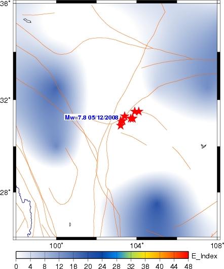
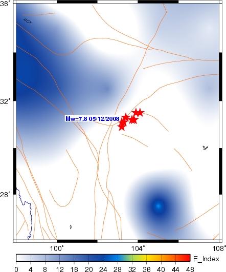

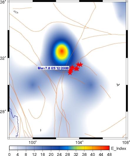
31 Anomaly maps of daily night-time TIR earth outgoing radiation over epicenter of M7.8 Eastern Sichuan, China May 3- May 14, 2008, 03 May 04 May 05 May 06 May 07 May 09 May 10 May 11 May 12 May 13 May 08 May 14 May [Ouzounov et al, 2008]

32 Time-series of daily night-time OLR variability for April 25 May 25, 2008 over the epicentral area M7.8 Eastern Sichuan [Ouzounov et al, 2008]
33 Summary Using the fundamental principles of atmospheric physics the LAIC model was updated in order to explain the most of the observed atmospheric thermal variations observed before the earthquakes Sensor Web approach of using different satellite sensors and different geophysical fields strongly support the model estimates Practical applications could be build for automatic identification of the earthquake precursors Why we need partnership and International cooperation? The complex and dynamic nature of the earthquake hazard risk on global scale requires spatial, spectral, and temporal coverage that is far beyond any single satellite mission.
34 Now, you might be interested to read more about: 1. Ouzounov D., S. Habib and S. 2008,Ambrose A Multisensor approach analyzing atmospheric signals for possible earthquake precursors. Application of Remote Sensing for Risk Management, In the book Risk Wise, International Disaster and Risk Conference (IDRC) Davos, Switzerland, Tudor Rose, pp Ouzounov D., S. Habib, F. Policelli, P. Taylor, 2007, Learning new methodologies to deal with large disasters: Near space monitoring of thermal signals associated with large earthquakes. In the book Elements of Life, World Meteorological Organization, Ouzounov D., D. Liu, C. Kang, G.Cervone, M. Kafatos, P. Taylor, Outgoing Long Wave Radiation Variability from IR Satellite Data Prior to Major Earthquakes, Tectonophysics, Volume 431, Issues 1-4, 20 February, pp Parrot M. and D.Ouzounov, 2006.Surveying the Earth's Electromagnetic Environment From Space, EOS, Transactions of American Geophysical Union,26 December,Vol.87, 52, pp Pulinets S., D. Ouzounov, A. Karelin, K. Boyarchuk, L. Pokhmelnykh, The Physical Nature of Thermal Anomalies Observed Before Strong Earthquakes, Physics and Chemistry of the Earth, 31, Pulinets S., D. Ouzounov L. Ciraolo, R. Singh, G. Cervone, A. Leyva, M.Dunajecka, Karelin, K. Boyarchuk, Thermal, Atmospheric and Ionospheric Anomalies Around the time of Colima M7.8 Earthquake of January 21, 2003, Annales Geophysicale, 24, Ouzounov D., N. Bryant, T. Logan, S. Pulinets, P.Taylor, Satellite thermal IR phenomena associated with some of the major earthquakes in , Physics and Chemistry of the Earth, 31,
35 Thank you Questions? Send to
Interdisciplinary Framework to Reveal Earthquake Precursory Phenomena in Seismically Active Areas
 Interdisciplinary Framework to Reveal Earthquake Precursory Phenomena in Seismically Active Areas D.Ouzounov 1,2, S.Pulinets 3, M.Kafatos 1, P.Taylor 2 1 Chapman University, Orange, CA 92866, USA 2 NASA
Multi-parameter observations of atmospheric pre-earthquake signals and their validation: Potential for Future
 Multi-parameter observations of atmospheric pre-earthquake signals and their validation: Potential for Future Dimitar Ouzounov and Menas Kafatos Chapman University, Orange, CA CSEP Workshop, May 5-7, 2013
Early Warning of Earthquakes Using Earth, Ocean and Atmospheric Parameters Observed From Satellite Data
 Early Warning of Earthquakes Using Earth, Ocean and Atmospheric Parameters Observed From Satellite Data Ramesh P. Singh Department of Civil Engineering, Indian Institute of Technology, Kanpur 208 016,
Space-borne observations of atmospheric pre-earthquake signals in seismically active areas.
 Space-borne observations of atmospheric pre-earthquake signals in seismically active areas. Ouzounov D.P. 1, Pulinets S.A. 2, Davidenko D.A. 3, Kafatos M. 1, Taylor P.T. 4 1 CEESMO, Chapman University,
A pilot project on the comphrensive diagnosis of earthquake precursors on Sakhalin Island: Experiment results from 2007
 A pilot project on the comphrensive diagnosis of earthquake precursors on Sakhalin Island: Experiment results from 2007 Alexey Romanov, Youry Urlichich, Sergey Pulinets, Alexander Romanov and Victor Selin
Satellite Based Precursor Observation Technique (SPOT) A Study on Earthquakes Occurred During Jan March, 2016 with Magnitude Greater Than 7.
 A Study on Earthquakes Occurred During Jan March, 2016 with Magnitude Greater Than 7.") www.cafetinnova.org Indexed in Scopus Compendex and Geobase Elsevier, Geo-Ref Information Services-USA, List B of Scientific Journals, Poland, Directory of Research Journals ISSN 0974-5904, Volume 09,
www.cafetinnova.org Indexed in Scopus Compendex and Geobase Elsevier, Geo-Ref Information Services-USA, List B of Scientific Journals, Poland, Directory of Research Journals ISSN 0974-5904, Volume 09,
Third International Conference on Early Warning Bonn, Germany March 27-29, 2006
 Third International Conference on Early Warning Bonn, Germany March 27-29, 2006 Acquiring Comprehensive Observations using an integrated Sensor Web for Early Warning Shahid Habib, D.Sc., P.E. NASA Goddard
Possible Abnormal Phenomenon of the Atmospheric Water Vapor before Hengchun Earthquake
 PIERS ONLINE, VOL. 6, NO. 1, 2010 21 Possible Abnormal Phenomenon of the Atmospheric Water Vapor before Hengchun Earthquake Yuntao Ma 1, 3, Yiyang Zhao 1, Shanjun Liu 1, and Lixin Wu 1, 2 1 Institute for
Revealing pre-earthquake signatures in atmosphere and ionosphere associated with 2015 M7.8 and M7.3 events in Nepal. Preliminary results
 Revealing pre-earthquake signatures in atmosphere and ionosphere associated with 2015 M7.8 and M7.3 events in Nepal. Preliminary results Dimitar Ouzounov 1, Sergey Pulinets 2, Dmitry Davidenko 2 1 Center
An early warning system for coastal earthquakes
 Advances in Space Research 37 (2006) 636 642 www.elsevier.com/locate/asr An early warning system for coastal earthquakes Guido Cervone a, *, Menas Kafatos a, Domenico Napoletani b, Ramesh P. Singh a,c
Two-step method to extract seismic microwave radiation anomaly: Case study of M S 8.0 Wenchuan earthquake
 Earthq Sci (2011)24: 577 582 577 doi:10.1007/s11589-011-0819-x Two-step method to extract seismic microwave radiation anomaly: Case study of M S 8.0 Wenchuan earthquake Yuntao Ma 1,2 Shanjun Liu 1, Lixin
Study of outgoing longwave radiation anomalies associated with Haiti earthquake
 doi:10.5194/nhess-10-2169-2010 Author(s) 2010. CC Attribution 3.0 License. Natural Hazards and Earth System Sciences Study of outgoing longwave radiation anomalies associated with Haiti earthquake P. Xiong
2018 REVIEW OF DISASTER EVENTS
 2018 REVIEW OF DISASTER EVENTS Supplementary Information* BRUSSELS, 24 January, 2019 In 2018, there were 281 climate-related and geophysical events recorded in the EM-DAT (International Disaster Database)
THERMAL REMOTE SENSING TECHNIQUES FOR STUDYING EARTHQUAKE ANOMALIES IN 2013 BALOCHISTAN EARTHQUAKES. G. Kaplan 1 and U. Avdan 2
 THERMAL REMOTE SENSING TECHNIQUES FOR STUDYING EARTHQUAKE ANOMALIES IN 2013 BALOCHISTAN EARTHQUAKES ABSTRACT: G. Kaplan 1 and U. Avdan 2 1 PhD Candidate, GIS and Remote Sensing program, Anadolu University,
Surface Anomalies Prior to Earthquakes
 Surface Anomalies Prior to Earthquakes Habibeh Valizadeh, Shattri B. Mansor Husaini Omar and Farid Azad Department of Civil Engineering Universiti Putra Malaysia Serdang, Selangor Malaysia shattri@eng.upm.edu.my
Surface latent heat flux as an earthquake precursor
 Surface latent heat flux as an earthquake precursor S. Dey, R. P. Singh To cite this version: S. Dey, R. P. Singh. Surface latent heat flux as an earthquake precursor. Natural Hazards and Earth System
Weather Satellite Data Applications for Monitoring and Warning Hazard at BMKG
 The 5th Meeting of the Coordinating Group of the RA II WIGOS Satellite Project 21 October 2017, Vladivostok city, Russky Island, Russia Far Eastern Federal University Weather Satellite Data Applications
Atmospheric and thermal anomalies observed around the time of strong earthquakes in México
 Atmósfera 18(4), 235-247 (2005) Atmospheric and thermal anomalies observed around the time of strong earthquakes in México M. A. DUNAJECKA Instituto de Geografía, Universidad Nacional Autónoma de México,
Assessing Hazards and Risk
 Page 1 of 6 EENS 204 Tulane University Natural Disasters Prof. Stephen A. Nelson Assessing Hazards and Risk This page last updated on 07-Jan-2004 As discussed before, natural disasters are produced by
Forecasting Earthquakes and Space Weather
 On the Ground at the AGU Conference Forecasting Earthquakes and Space Weather By Peter Martinson SAN FRANCISCO, Dec. 7, 2011 The most revolutionary and important advances in human knowledge always bear
Earthquakes. Earthquake Magnitudes 10/1/2013. Environmental Geology Chapter 8 Earthquakes and Related Phenomena
 Environmental Geology Chapter 8 Earthquakes and Related Phenomena Fall 2013 Northridge 1994 Kobe 1995 Mexico City 1985 China 2008 Earthquakes Earthquake Magnitudes Earthquake Magnitudes Richter Magnitude
Lessons from the 2004 Sumatra earthquake and the Asian tsunami
 Lessons from the 2004 Sumatra earthquake and the Asian tsunami Kenji Satake National Institute of Advanced Industrial Science and Technology Outline 1. The largest earthquake in the last 40 years 2. Tsunami
The BEYOND Center of Excellence for monitoring natural disasters from space
 The BEYOND Center of Excellence for monitoring natural disasters from space Ioannis Papoutsis National Observatory of Athens Institute for Astronomy, Astrophysics, Space Applications & Remote Sensing MOWE-IT
RS / GIS for Disaster Management. Some Important Definitions. Classifications of Natural Disasters. Disasters W/Some Human Influence
 RS / GIS for Disaster Management A Basic Introduction to Natural Disasters Using Remote Sensing & GIS ~~~~~~~~~~ Rev. Ronald J. Wasowski, C.S.C. Associate Professor of Environmental Science University
Mainstream Space Technology in Implementing SFDRR - GPSTAR. Srimal Samansiri Disaster Management Centre Government of Sri Lanka
 Mainstream Space Technology in Implementing SFDRR - GPSTAR Srimal Samansiri Disaster Management Centre Government of Sri Lanka SFDRR Priority Actions Effective use of Space technology in SFDRR Priority
Statistical Study of the Ionospheric Density Variation Related to the 2010 Chile Earthquake and Measured by the DEMETER Satellite
 WDS'1 Proceedings of Contributed Papers, Part II, 189 193, 21. ISBN 978-8-7378-14-8 MATFYZPRESS Statistical Study of the Ionospheric Density Variation Related to the 21 Chile Earthquake and Measured by
Satellite Meteorology. Protecting Life and Property Around the World
 Satellite Meteorology Protecting Life and Property Around the World The Value of Forecasting Severe Weather Flooding events across Europe in August 2002 cost in the region of 20 billion; 20,000 people
Abdolreza Ansari Amoli. Remote Sensing Department Iranian Space Agency
 Risk Assessment and Mapping Using Earth Observation Data In Iran Abdolreza Ansari Amoli Remote Sensing & GIS Expert Remote Sensing Department Iranian Space Agency Different Types of Disasters in Iran Epidemic
Tectonic Processes and Hazards Enquiry Question 1: Why are some locations more at risk from tectonic hazards?
 Tectonic Processes and Hazards Enquiry Question 1: Why are some locations more at risk from tectonic hazards? Key words Basalt Andesite Rhyolite Benioff Zone Subduction zone Crustal fracturing Definition
Country Report - Singapore
 Country Report - Singapore The 5th Meeting of the Coordinating Group Vladivostok city, Russky Island, Russia Far Eastern Federal University of the RA II WIGOS Satellite Project 21 October 2017 Outline
COMPOSITION and PHYSICAL PROPERTIES GENERAL SUBJECTS. GEODESY and GRAVITY
 COMPOSITION and PHYSICAL PROPERTIES Composition and structure of the continental crust Composition and structure of the core Composition and structure of the mantle Composition and structure of the oceanic
Crisis Management and Natural Disasters Overview of JRC operational or pre-operational activities A. Annunziato, D. Al-Khudhairy
 Papagayo, Costarica 3-4 November 2009 Security Science and The Americas 1 Joint Research Centre (JRC) Crisis Management and Natural Disasters Overview of JRC operational or pre-operational activities A.
GI Technology for Disaster Management
 GI Technology for Disaster Management 17 th ICC on the Regional Space Applications Programme for Sustainable Development (RESAP) 26 th Nov 2013 Bangkok Thailand Period and time of seasonal in thailand
I. Locations of Earthquakes. Announcements. Earthquakes Ch. 5. video Northridge, California earthquake, lecture on Chapter 5 Earthquakes!
 51-100-21 Environmental Geology Summer 2006 Tuesday & Thursday 6-9:20 p.m. Dr. Beyer Earthquakes Ch. 5 I. Locations of Earthquakes II. Earthquake Processes III. Effects of Earthquakes IV. Earthquake Risk
Tuckahoe Union Free School District Earth Science Curriculum Map/Scope and Sequence. Compiled by: Mark Dineen
 Tuckahoe Union Free School District Earth Science Curriculum Map/Scope and Sequence Compiled by: Mark Dineen SEPTEMBER Tuckahoe Union Free School District Curriculum Map- Earth Science Mr. Dineen Texts:
Activities and Outlook related to Disaster Reduction in CMA
 Activities and Outlook related to Disaster Reduction in CMA WANG Bangzhong China Meteorological Administration March 15-17 2006 ADENDA Situation about MD and related disasters in CHINA Guidance for MD/RD
Current and Upcoming NASA Hurricane Measurement Missions National Hurricane Conference
 NASA Science Mission Directorate Earth Science Division Applied Sciences Program Current and Upcoming NASA Hurricane Measurement Missions National Hurricane Conference April 18, 2017 Formulation Implementation
TSUNAMI GRID CALCULATION DATABASE AND THE JRC GLOBAL TSUNAMI CALCULATION SYSTEM
 Presentation of CRITECH Action November 2007 1 TSUNAMI GRID CALCULATION DATABASE AND THE JRC GLOBAL TSUNAMI CALCULATION SYSTEM A. Annunziato IDRC Davos August 2008 Content Presentation of CRITECH Action
EXPLORE PLATE TECTONICS & MORE THROUGH GPS DATA. Shelley Olds, UNAVCO April 12, 2018 NGSS Webinar
 EXPLORE PLATE TECTONICS & MORE THROUGH GPS DATA Shelley Olds, UNAVCO April 12, 2018 NGSS Webinar Today s Outline Central question: How do we know the tectonic plates are still moving? -- What evidence
JICA s Experiences of Connecting Japanese Science & Technologies for Disaster Risk Reduction in Developing Countries
 JICA s Experiences of Connecting Japanese Science & Technologies for Disaster Risk Reduction in Developing Countries Junji WAKUI Deputy Director General, Group Leader Disaster Risk Reduction Group Global
2005 Annual Report of Inter-Association (IAGA/IASPEI/IAVCEI) Working Group of Electromagnetic Studies on Earthquakes and Volcanoes (EMSEV)
 Working Group of Electromagnetic Studies on Earthquakes and Volcanoes (EMSEV)") 1 2005 Annual Report of Inter-Association (IAGA/IASPEI/IAVCEI) Working Group of Electromagnetic Studies on Earthquakes and Volcanoes (EMSEV) By Seiya Uyeda, Malcolm Johnston and Jacques Zlotnicki Contents:
1 2005 Annual Report of Inter-Association (IAGA/IASPEI/IAVCEI) Working Group of Electromagnetic Studies on Earthquakes and Volcanoes (EMSEV) By Seiya Uyeda, Malcolm Johnston and Jacques Zlotnicki Contents:
Satellites, Weather and Climate Module 1: Introduction to the Electromagnetic Spectrum
 Satellites, Weather and Climate Module 1: Introduction to the Electromagnetic Spectrum What is remote sensing? = science & art of obtaining information through data analysis, such that the device is not
Mission Objectives and Current Status of GOSAT (IBUKI) Japan Aerospace Exploration Agency Yasushi Horikawa
 Japan Aerospace Exploration Agency Yasushi Horikawa") Mission Objectives and Current Status of GOSAT (IBUKI) Japan Aerospace Exploration Agency Yasushi Horikawa 1 Background of the Launch of the GOSAT project 1997 Adoption of the Kyoto Protocol 2002 Ratification
Mission Objectives and Current Status of GOSAT (IBUKI) Japan Aerospace Exploration Agency Yasushi Horikawa 1 Background of the Launch of the GOSAT project 1997 Adoption of the Kyoto Protocol 2002 Ratification
National Aeronautics and Space Administration. Earth Day is everyday at NASA. activity booklet
 National Aeronautics and Space Administration Earth Day is everyday at NASA activity booklet Earth Day is everyday at NASA NASA s Fleet of Earth Observing Satellites ACRIMSAT Landsat 7 Aqua SORCE Terra
J M MIRANDA UNIVERSITY OF LISBON THE USE OF REMOTE SENSING FOR EARTHQUAKE RISK ASSESSMENT AND MITIGATION
 1 THE USE OF REMOTE SENSING FOR EARTHQUAKE RISK ASSESSMENT AND MITIGATION 2 the observation of strong ground motion and aftershock sequences as well as the investigation of the destruction from these earthquakes
5.2 IDENTIFICATION OF HAZARDS OF CONCERN
 5.2 IDENTIFICATION OF HAZARDS OF CONCERN 2016 HMP Update Changes The 2011 HMP hazard identification was presented in Section 3. For the 2016 HMP update, the hazard identification is presented in subsection
Subject Classification
 Istituto Nazionale di Geofisica e Vulcanologia earth-prints home page roma library bologna library catania library milano library napoli library palerm Subject Classification Earth-prints organize its
DROUGHT ASSESSMENT USING SATELLITE DERIVED METEOROLOGICAL PARAMETERS AND NDVI IN POTOHAR REGION
 DROUGHT ASSESSMENT USING SATELLITE DERIVED METEOROLOGICAL PARAMETERS AND NDVI IN POTOHAR REGION Researcher: Saad-ul-Haque Supervisor: Dr. Badar Ghauri Department of RS & GISc Institute of Space Technology
The Mega-Earthquakes of Chile: Seismology and the Sounds of the Earth
 The Mega-Earthquakes of Chile: Seismology and the Sounds of the Earth Michael Wysession Department of Earth and Planetary Sciences Washington University, St. Louis, MO Puerto Montt, Chile, November 6,
The new challenge of community-based environmental monitoring and information systems: the Citizens Obsrevatories Tito Scalo (PZ) 13 July 2016
 13 July 2016") The new challenge of community-based environmental monitoring and information systems: the Citizens Obsrevatories Tito Scalo (PZ) 13 July 2016 Involving citizens in environmental monitoring and awareness:
The new challenge of community-based environmental monitoring and information systems: the Citizens Obsrevatories Tito Scalo (PZ) 13 July 2016 Involving citizens in environmental monitoring and awareness:
Earthquake Hazards. Tsunami
 Earthquake Hazards Tsunami Review: What is an earthquake? Earthquake is the vibration (shaking) and/or displacement of the ground produced by the sudden release of energy. The point inside the Earth where
WMO Statement on the State of the Global Climate Preliminary conclusions for 2018 and WMO Greenhouse Bulletin
 WMO Statement on the State of the Global Climate Preliminary conclusions for 2018 and WMO Greenhouse Bulletin Dr Elena Manaenkova Deputy Secretary General World Meteorological Organisation Statement on
CORRELATION BETWEEN TEMPERATURE CHANGE AND EARTHQUAKE IN BANGLADESH
 CORRELATION BETWEEN TEMPERATURE CHANGE AND EARTHQUAKE IN BANGLADESH A. Hossain *, F. Kabir & K. Roy Department of Civil Engineering, Rajshahi University of Engineering & Technology, Rajshahi, Bangladesh
Evidence for plate tectonics
 Evidence for plate tectonics See class powerpoint Printed tables 2x essay Qs markschemes Discuss/Evaluate the evidence for plate tectonics Discuss/evaluate the evidence for plate tectonics Essay: To what
GEO-VIII November Geohazard Supersites and Natural Laboratories Progress Report. Document 9
 GEO-VIII 16-17 November 2011 Geohazard Supersites and Natural Laboratories Progress Report Document 9 This document is submitted to GEO-VIII for information. Geohazard Supersites and Natural Laboratories
Interpretation of Polar-orbiting Satellite Observations. Atmospheric Instrumentation
 Interpretation of Polar-orbiting Satellite Observations Outline Polar-Orbiting Observations: Review of Polar-Orbiting Satellite Systems Overview of Currently Active Satellites / Sensors Overview of Sensor
Dust Occurrence Enhancement Consolidate Technique over West and South West of Iran Using Spectral Properties of MODIS
 Dust Occurrence Enhancement Consolidate Technique over West and South West of Iran Using Spectral Properties of MODIS Saviz Sehatkashani Science and Research Branch, Islamic Azad University, Tehran, Iran
Earthquake Hazards. Tsunami
 Earthquake Hazards Tsunami Review: What is an earthquake? Earthquake is the vibration (shaking) and/or displacement of the ground produced by the sudden release of energy. The point inside the Earth where
Southern California Earthquake Center Collaboratory for the Study of Earthquake Predictability (CSEP) Thomas H. Jordan
 Thomas H. Jordan") Southern California Earthquake Center Collaboratory for the Study of Earthquake Predictability (CSEP) Thomas H. Jordan SCEC Director & Professor, University of Southern California 5th Joint Meeting of
Southern California Earthquake Center Collaboratory for the Study of Earthquake Predictability (CSEP) Thomas H. Jordan SCEC Director & Professor, University of Southern California 5th Joint Meeting of
4.1 Hazard Identification: Natural Hazards
 data is provided in an annex, it should be assumed that the risk and potential impacts to the affected jurisdiction are similar to those described here for the entire Sacramento County Planning Area. This
DISATER MANAGEMENT IN LIBRARIES
 DISATER MANAGEMENT IN LIBRARIES by S. Padmashree National Seminar cum Workshop on Trends & Challenges in LIS Education and Profession March 24 25 th 2017 Andhra University, Visakhapatnam Disaster - A
Earth Observatory of Singapore. Nina Lin 22 Jan 2018
 Earth Observatory of Singapore Nina Lin 22 Jan 2018 EOS Our Mission Our Mission Director Prof. Kerry Sieh The Earth Observatory of Singapore conducts fundamental research on earthquakes, volcanic eruptions,
Ionospheric anomalies possibly associated with M>6.0 earthquakes in the Japan area during and the Tohoku Earthquake (Mw9.
 Ionospheric anomalies possibly associated with M>6.0 earthquakes in the Japan area during 1998-2010 and the 20110311 Tohoku Earthquake (Mw9.0) K. Hattori 1, S. Kon 1, S. Hirooka 1, T. Ichikawa 1, M. Nishihashi
Key to Understanding Pre-Earthquake Phenomena
 Stress-Activated Positive Hole Charge Carriers Key to Understanding Pre-Earthquake Phenomena Friedemann Freund friedemann.t.freund@nasa.gov Carl Sagan Center Physics Department NASA Ames Research Center
Fifty Years of Operational Environmental Satellites: The U.S. Experience
 United Nations Committee on the Peaceful Uses of Outer Space Vienna, Austria June 15, 2010 Fifty Years of Operational Environmental Satellites: The U.S. Experience Mr. Charles Baker Deputy Assistant Administrator
The Science and Policy of Natural Hazards
 Image courtesy of USGS. 12.103 Image courtesy of NOAA. The Science and Policy of Natural Hazards Image courtesy of USGS. Image courtesy of NOAA. Topics Four categories of hazards will be investigated in
STUDY ON TSUNAMIGENIC EARTHQUAKE CRITERIA FOR THE INDONESIAN TSUNAMI EARLY WARNING SYSTEM
 STUDY ON TSUNAMIGENIC EARTHQUAKE CRITERIA FOR THE INDONESIAN TSUNAMI EARLY WARNING SYSTEM Nanang T. Puspito 1 1 Geophysics Research Group, Faculty of Mining and Petroleum Engineering, Institute of Technology
NATIONAL FRAMEWORK FOR FLOOD DISASTER MANAGEMENT IN INDONESIA. 11 th GEOSS ASIA PASIFIC SYMPOSIUM Kyoto, October 2018
 NATIONAL FRAMEWORK FOR FLOOD DISASTER MANAGEMENT IN INDONESIA 11 th GEOSS ASIA PASIFIC SYMPOSIUM Kyoto, 24-26 October 2018 1 OUTLINE Disasters in Indonesia The Disaster Management Mechanism Current Status
Report for 15th PCGIAP Meeting at 18th UNRCC-AP Working Group 1 Regional Geodesy
 Report for 15th PCGIAP Meeting at 18th UNRCC-AP Working Group 1 Regional Geodesy Chairman Shigeru Matsuzaka, Japan - shigeru@gsi.go.jp Vice Chairman Prof. Pengfei Cheng, China - chengpf@casm.ac.cn John
DIPLOMA IN DISASTER MANAGEMENT. (Non-Semester) (With effect from the academic year )
 (With effect from the academic year )") DIPLOMA IN DISASTER MANAGEMENT (Non-Semester) (With effect from the academic year 2013-14) Eligibility for the Course Candidate should have passed the Higher Secondary Examination conducted by the Board
DIPLOMA IN DISASTER MANAGEMENT (Non-Semester) (With effect from the academic year 2013-14) Eligibility for the Course Candidate should have passed the Higher Secondary Examination conducted by the Board
GEOLOGICAL HAZARD MITIGATION STRATEGY IN INDONESIA
 GEOLOGICAL HAZARD MITIGATION STRATEGY IN INDONESIA Surono Head of Geological Agency presented in: The 2nd Global Summit of Research Institutes for Disaster Risk Reduction Kihada Hall, Uji Campus, Kyoto
Geohazard Supersites and Natural Laboratories
 Geohazard Supersites and Natural Laboratories FRINGE 2011, Frascati, Italy, September 19, 2011 Wolfgang Lengert, ESA Falk Amelung, University of Miami, GEO task lead Craig Dobson, NASA, CEOS task lead
WMO Global Data-Processing and Forecasting System Operational weather forecast product delivery relevant to SDSWS
 WMO Global Data-Processing and Forecasting System Operational weather forecast product delivery relevant to SDSWS Peter Chen World Weather Watch Department, WMO WMO/GEO Expert Meeting for an International
They include earthquakes, volcanic eruptions, floods, landslides, and other processes and occurrences. They are included in the broader concept of.
 They include earthquakes, volcanic eruptions, floods, landslides, and other processes and occurrences. They are included in the broader concept of. In general, natural processes are labeled hazardous only
Natural Disasters & Assessing Hazards and Risk. Natural Hazards and Natural Disasters
 Page 1 of 9 EENS 3050 Tulane University Natural Disasters Prof. Stephen A. Nelson Natural Disasters & Assessing Hazards and Risk This page last updated on 09-Jan-2018 Natural Hazards and Natural Disasters
Modeling Radiological Consequences of Sever Accidents in BWRs: Review of Models Development, Verification and Validation
 Modeling Radiological Consequences of Sever Accidents in BWRs: Review of Models Development, Verification and Validation Mohamed GAHEEN Department of Research on Nuclear Safety and Radiological Emergencies,
5.2 IDENTIFICATION OF HAZARDS OF CONCERN
 5.2 IDENTIFICATION OF HAZARDS OF CONCERN 2015 HMP Update Changes The 2010 HMP hazard identification was presented in Section 6. For the 2015 HMP update, the hazard identification is presented in subsection
Pre-earthquake activity in North-Iceland Ragnar Stefánsson 1, Gunnar B. Guðmundsson 2, and Þórunn Skaftadóttir 2
 International Workshop on Earthquakes in North Iceland Húsavík, North Iceland, 31 May - 3 June 2016 Pre-earthquake activity in North-Iceland Ragnar Stefánsson 1, Gunnar B. Guðmundsson 2, and Þórunn Skaftadóttir
MODELLING FROST RISK IN APPLE TREE, IRAN. Mohammad Rahimi
 WMO Regional Seminar on strategic Capacity Development of National Meteorological and Hydrological Services in RA II (Opportunity and Challenges in 21th century) Tashkent, Uzbekistan, 3-4 December 2008
COURSE: General Science 15:1 GRADE LEVEL: 10/11
 COURSE: General Science 15:1 GRADE LEVEL: 10/11 MAIN/GENERAL TOPIC: UNIT 1 INQUIRY/PROBLEM SOLVING UNIT 2 OUR UNIVERSE: ASTRONOMY SUB-TOPIC: ESSENTIAL QUESTIONS: WHAT THE STUDENTS WILL KNOW OR BE ABLE
JOURNAL OF GEOPHYSICAL RESEARCH, VOL. 115, A09312, doi: /2010ja015313, 2010
 JOURNAL OF GEOPHYSICAL RESEARCH, VOL. 115,, doi:10.1029/2010ja015313, 2010 Temporal and spatial precursors in the ionospheric global positioning system (GPS) total electron content observed before the
Global Map: A Tool for Disaster Mitigation for the Asia and Pacific Region
 Global Map: A Tool for Disaster Mitigation for the Asia and Pacific Region D. R. Fraser Taylor Chair, International Steering Committee for Global Mapping (ISCGM) fraser_taylor@carleton.ca www. 18 th United
Lecture Outline Wednesday-Monday April 18 23, 2018
 Lecture Outline Wednesday-Monday April 18 23, 2018 Questions? Lecture Final Exam Lecture Section 1 Friday May 4, 8:00-10:00am Lecture Section 2 Friday May 4, 3:10-5:10 pm Final Exam is 70% new material
Atmospheric and ionospheric coupling phenomena related to large earthquakes
 Nat. Hazards Earth Syst. Sci. Discuss., doi:0./nhess-0-, 0 Published: June 0 c Author(s) 0. CC-BY.0 License. Atmospheric and ionospheric coupling phenomena related to large earthquakes M. Parrot (), V.
WEATHER AND CLIMATE EXTREMES MONITORING BASED ON SATELLITE OBSERVATION : INDONESIA PERSPECTIVE RIRIS ADRIYANTO
 WEATHER AND CLIMATE EXTREMES MONITORING BASED ON SATELLITE OBSERVATION : INDONESIA PERSPECTIVE RIRIS ADRIYANTO INDONESIA AGENCY FOR METEOROLOGY, CLIMATOLOGY AND GEOPHYSICS (BM KG) 1. INTRODUCTION - BMKG
Satellite Observations of the Great Mega Thrust Sumatra Earthquake Activities
 International Journal of Geoinformatics, Vol. 1, No. 4, December 2005 Satellite Observations of the Great Mega Thrust Sumatra Earthquake Activities A.K. Saraf, S. Choundhury and S. Dasgupta Department
Module 1, Investigation 3: Predicting Eruptions
 Module 1, Investigation 3: Predicting Eruptions Introduction Welcome! Volcanoes are either "active" or "extinct". Active means that the volcano has erupted during the past 10,000 years. It can also mean
Workshop on Drought and Extreme Temperatures: Preparedness and Management for Sustainable Agriculture, Forestry and Fishery
 Workshop on Drought and Extreme Temperatures: Preparedness and Management for Sustainable Agriculture, Forestry and Fishery 16-17 Feb.2009, Beijing, China Modeling Apple Tree Bud burst time and frost risk
NSF Expeditions in Computing. Understanding Climate Change: A Data Driven Approach. Vipin Kumar University of Minnesota
 NSF Expeditions in Computing Understanding Climate Change: A Data Driven Approach Vipin Kumar University of Minnesota kumar@cs.umn.edu www.cs.umn.edu/~kumar Vipin Kumar UCC Aug 15, 2011 Climate Change:
COUNTRY REPORT INDONESIA
 COUNTRY REPORT INDONESIA Badan Meteorologi Klimatologi dan Geofisika (BMKG) Agency For Meteorology, Climatology, and Geophysics Republic of Indonesia DKI Jakarta, Indonesia Tel. (021) 4246321 Email: pcs@bmkg.go.id
What are the social, technical, environmental and economic benefits and opportunities of accessing and sharing geodetic data?
 What are the social, technical, environmental and economic benefits and opportunities of accessing and sharing geodetic data? Graeme Blick Group Manager Positioning and Resilience Land Information New
Earthquake Hazards. Tsunami
 Earthquake Hazards Tsunami Measuring Earthquakes Two measurements that describe the power or strength of an earthquake are: Intensity a measure of the degree of earthquake shaking at a given locale based
Disclaimer. This report was compiled by an ADRC visiting researcher (VR) from ADRC member countries.
 from ADRC member countries.") Disclaimer This report was compiled by an ADRC visiting researcher (VR) from ADRC member countries. The views expressed in the report do not necessarily reflect the views of the ADRC. The boundaries and
Disclaimer This report was compiled by an ADRC visiting researcher (VR) from ADRC member countries. The views expressed in the report do not necessarily reflect the views of the ADRC. The boundaries and
CONTENTS PREFACE. VII 1. INTRODUCTION VARIOUS TOPICS IN SEISMOLOGY TECTONICS PERTAINING TO EQ PREDICTION 5
 CONTENTS PREFACE. VII 1. INTRODUCTION.... 1 2. VARIOUS TOPICS IN SEISMOLOGY TECTONICS PERTAINING TO EQ PREDICTION 5 2.1. Spatial distribution of strong EQs. 5 2.1.1. Mapping of major seismic fracture zones
Back to basics: From Sputnik to Envisat, and beyond: The use of satellite measurements in weather forecasting and research: Part 1 A history
 Back to basics: From Sputnik to Envisat, and beyond: The use of satellite measurements in weather forecasting and research: Part 1 A history Roger Brugge 1 and Matthew Stuttard 2 1 NERC Data Assimilation
THE FUTURE OF U.S. WEATHER CATASTROPHES
 Source: NASA THE FUTURE OF U.S. WEATHER CATASTROPHES Mark C. Bove, CPCU, ARe Senior Research Meteorologist Munich Reinsurance America, Inc. AIMU Marine Insurance Day 2 October 2015 Agenda Natural Catastrophes
Remote Detection and Monitoring of Volcanic Eruptions in the East African Rift
 Remote Detection and Monitoring of Volcanic Eruptions in the East African Rift Simon Carn 1, David Fee 2, Fred Prata 3 1 Department of Geological and Mining Engineering and Sciences, Michigan Technological
Country Report. KAZAKHSTAN DAN of SENTINEL ASIA INITIATIVE
 Country Report KAZAKHSTAN DAN of SENTINEL ASIA INITIATIVE Putrajaya, 2011 LAND RESOURCES OF KAZAKHSTAN Area 2,72 mln km 2 Population 16 Mln Land use Area Mln. ha % Territory of Republic 272,4 Agriculture
ANNUAL CLIMATE REPORT 2016 SRI LANKA
 ANNUAL CLIMATE REPORT 2016 SRI LANKA Foundation for Environment, Climate and Technology C/o Mahaweli Authority of Sri Lanka, Digana Village, Rajawella, Kandy, KY 20180, Sri Lanka Citation Lokuhetti, R.,
Storm Surge/Coastal Inundation State of the Union. Jamie Rhome Storm Surge Team Lead NOAA/National Hurricane Center
 Storm Surge/Coastal Inundation State of the Union Jamie Rhome Storm Surge Team Lead NOAA/National Hurricane Center 2 Tampa: Cat 5 Scenario 3 4 The Stakes are High Combination of SLR and increasing coastal