Modernization of the National Spatial Reference System 2022 Datum. Jacksonville Chapter July 2018
|
|
|
- Anissa Nichols
- 5 years ago
- Views:
Transcription


1 Modernization of the National Spatial Reference System 2022 Datum Jacksonville Chapter July 2018

2 Randy Tompkins, PSM, PLS Geomatics Project Manager Surveyor, Hydrographer, & Geodesist DRMP, Inc. Jacksonville, FL (904) Credit where credit is due: Most of the slides and data shown were created by Dr. DruSmith, Michael Dennis, and the Staff National Geodetic Survey (NGS)
3 Answers What is changing? All horizontal datums and vertical datums in the NSRS NAD 83, NAVD 88, etc Why? Predominantly to keep up with technology The current datums have systematic errors exceeding 1 meter. New GPS Block III satellites stated Autonomous m (95%) Global proliferation of real time cm-accuracy positioning (in the hands of people who have no understanding of geodesy, datums, plate tectonics, error sources or other subtleties) is rapidly approaching. Many surveying, mapping and navigation professionals already enjoy this accuracy. When is it changing? No later than December 31, 2022 Will it be an immediate or gradual change? Immediate
4 Answers Possible impacts? Every historic position (on a map, chart, survey, etc) with an assumed accuracy of better than 1 meter will become obsolete Transformations will exist before 2022 to help Every piece of navigating, mapping and surveying software will become obsolete NGS is working with industry to get ahead of this Will there be conversion tables from the old datum? Not in the sense of a book with pages and pages of numbers. But there will be digital products available to transform from old to new.
5 Answers Is WGS 84 updated too? Not necessarily WGS-84 is a military system. The military is not beholden to the civilian spatial reference system. But NGS is in contact with NGA about co-defining the new system with the latest update to WGS-84
6 Reminder WGS-84 is not part of the NSRS It is a military-controlled system Raw data from GPS satellites are in WGS84 That does not matter if your handheld device is only accurate to +/-10m. All civilian federal agencies are required to work in the NSRS (as per OMB A-16) NAD 83 is part of the NSRS The UTM is not necessarily WGS-84, any data processed in North America, using NGS CORS or OPUS is in NAD 83 and the coordinates would be in the projection of the user s control. i.e. UTM (NAD83(2011)), (NAD83(2011)), UTM (NAD83(2007)), UTM (NAD83(1990)).. Right now, it is possible that the uninformed user would say that the data is in UTM (WGS84) when it is really in UTM (NAD83(2011)) Replacing NAD 83 will impact the DOD if you have received survey quality data for any project in North America. I do not know about the rest of the world.

 NAD 83(PA11) The Pacific")
 The Mariana Terrestrial Reference Frame of")
7 Replacing the NAD 83 s OLD NAD 83(2011) NEW The North American Terrestrial Reference Frame of 2022 (NATRF2022) The Caribbean Terrestrial Reference Frame of 2022 (CATRF2022) NAD 83(PA11) The Pacific Terrestrial Reference Frame of 2022 (PATRF2022) NAD 83(MA11) The Mariana Terrestrial Reference Frame of 2022 (MATRF2022)


8 Replacing NAVD 88 Orthometric Heights NAVD 88 Normal Orthometric Heights Dynamic Heights Gravity Geoi Undulations OLD PRVD 02 VIVD09 ASVD02 NMVD03 GUVD04 IGLD 85 IGSN71 GEOID12B NEW The North American- Pacific Geopotential Datum of 2022 (NAPGD2022) Will include GEOID2022 Deflections of the Vertical DEFLEC12B
9 Q: When should I care? A: When your accuracy needs are smaller than about 4 meters Expected latitude/longitude changes: 0-2 meters CONUS 2+ meters Alaska 4+ meters Hawaii Expected ( MSL ) height changes: 0-2 meters CONUS 2+ meters Alaska Unclear Hawaii Plus, time-dependent changes to all of these at ~few cm/year

10 Q: When should I care?

11 Q: When should I care?

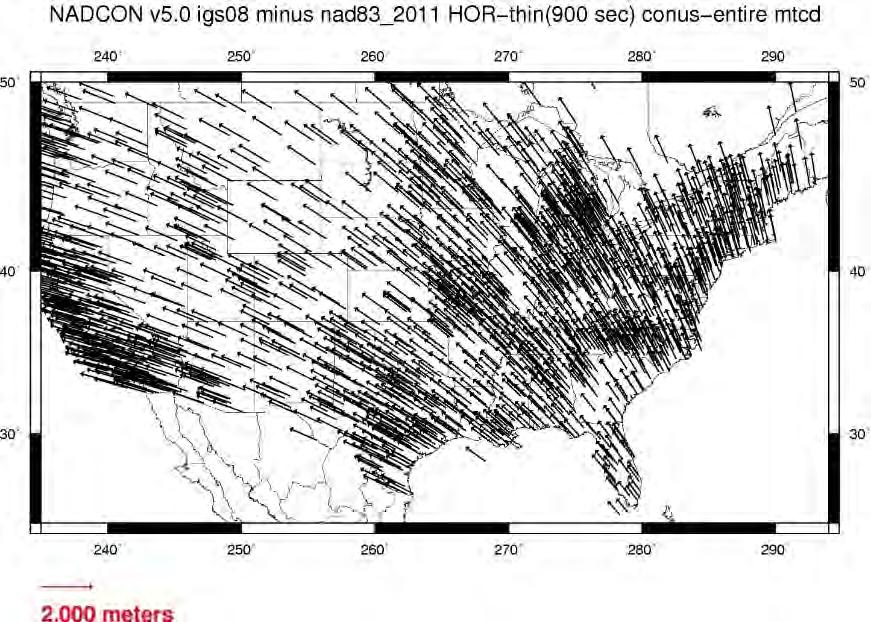
12 Expected changes to horizontal positions


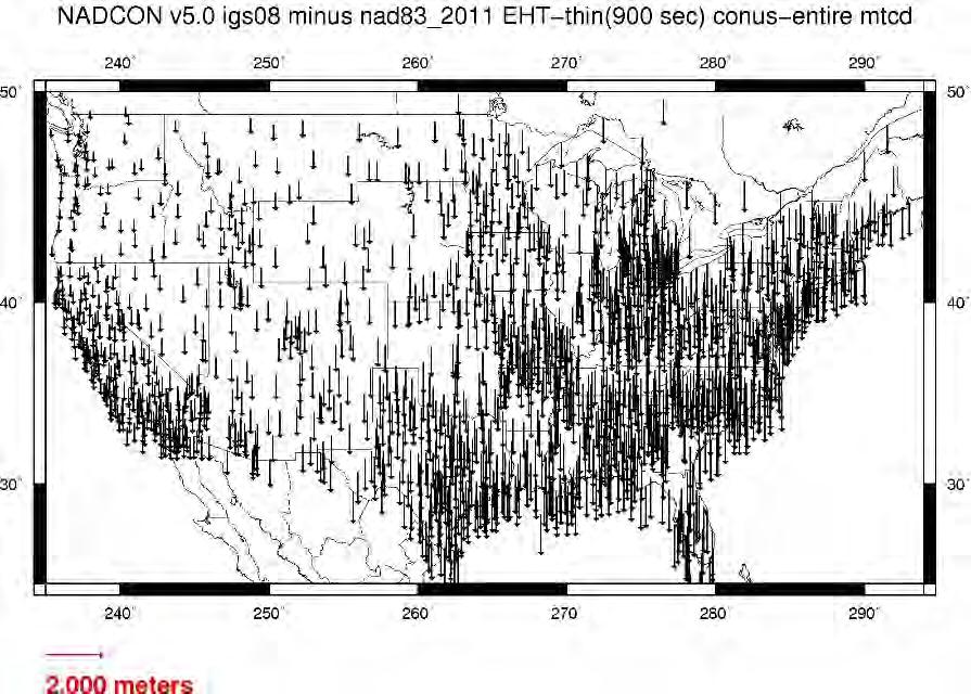
13 Expected changes to orthometric heights Expected changes to orthometric heights
14 Fixed-Epoch Transformation NAD 83 to 2022
 Tampa H = 0.75 m (2.5 ft) E = -1.54 m (-5.0 ft) O= + 0.04 m (+ 0.1 ft) Key West H = 0.66 m (2.2 ft) E = -1.63 m (-5.3 ft) O= + 0.")
 O = + 0.01 m (0.03 ft) Miami H = 0.67 m (2.2 ft) E = -1.62 m (-5.3 ft) O = + 0.06 m (+ 0.")
15 Predicted Positional Changes in 2022 Computed with xgeoid16b Pensacola H= 0.87 m (2.9 ft) E = m (-4.7 ft) O = m (-0.7 ft) Tampa H = 0.75 m (2.5 ft) E = m (-5.0 ft) O= m (+ 0.1 ft) Key West H = 0.66 m (2.2 ft) E = m (-5.3 ft) O= m (+ 0.7 ft) Jacksonville H= 0.80 m (2.6 ft) E = m (-4.9 ft) O = m (-0.4 ft) Orlando H = 0.75 m (2.2 ft) E = m (-5.1 ft) O = m (0.03 ft) Miami H = 0.67 m (2.2 ft) E = m (-5.3 ft) O = m (+ 0.2 ft) H=Horizontal Shift E=Ellipsoid Height Shift O=Orthometric Height Shift

 No Stop.")
16 What to do with historic charts/maps? Yes Yes Is the accuracy expected to be better than a few meters? Do you have trusted metadata which puts the chart in the NSRS? (Note, WGS 84 is not part of the NSRS) No Stop. You won t likely gain much by transforming No Use NADCON and VERTCON to update the datums in 2022 Stop. Transformation tools only work in the NSRS and only if you trust the metadata
17 Transformation tools NADCON Latitudes, longitudes, ellipsoid heights NAD 83 to the 2022 NSRS (IGS, NATRF2022, PATRF2022, MATRF2022, CATRF2022) VERTCON Orthometric ( MSL ) heights NAVD 88 to the 2022 NSRS (NAPGD2022)
18 Why Do We Need This?
19 The Ellipsoid Mathematical Model of The Earth N b THE ELLIPSOID MATHEMATICAL MODEL OF THE EARTH a a = Semi major axis b = Semi minor axis f = a-b = Flattening a S
20 Current United States Ellipsoid Definitions BESSEL 1841 a = 6,377, m 1/f = CLARKE 1866 (NAD 27) a = 6,378,206.4 m 1/f = CURRENT UNITED STATES GEODETIC REFERENCE SYSTEM (GRS 80) ELLIPSOID DEFINITIONS a = 6,378,137 m 1/f = WORLD GEODETIC SYSTEM (WGS 84) a = 6,378,137 m 1/f =
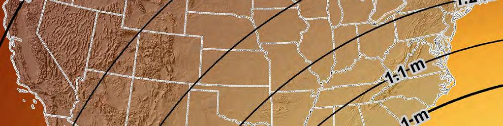
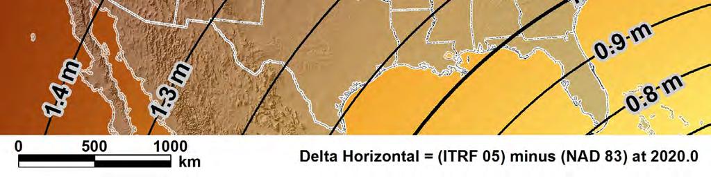
21 NAD 83 and ITRF / WGS84 ITRF / WGS 84 NAD 83 Earth Mass Center 2.2 m (3-D) (7.2 Feet) dx,dy,dz NAD 83 and ITRF GEOID
22 Simplified Concept of NAD 83 vs. ITRF/IGS h NAD83 h ITRF/IGS Earth s Surface ~ 1.5 m +/-0.2 m CONUS ~ 1.4 m +/-0.1 m AK ~ 1.9 m PR & VI ~ 2.5 m HI ~ 3.1 m AS ~ 2.3 m +/-0.1 m GU & NM ITRF/IGS Origin Columbus - COLB dx= m dy= m dz= m 3D = m NAD 83 Origin Identically shaped ellipsoids (GRS-80) a = 6,378, meters (semi-major axis) 1/f = (flattening)
23 Ellipsoid - Geoid Relationship H = Orthometric Height (NAVD88) h = Ellipsoidal Height (from GPS) N = Geoid Height (from geoid model) H = h -N H h ELLIPSOID - GEOID RELATIONSHIP N TOPOGRAPHIC SURFACE Ellipsoid GRS80 GEOID12B Geoid
24 Lateral Tectonic Plate Velocities

25 Lateral Tectonic Plate Velocities


26 Tectonic Plate Velocities Horizontal Vertical IGS08 Velocities Columbus COLB N = m/yr E = m/yr U = m/yr


27 Federal Register Notice Announces SPCS2022 Policy and Procedures Public comment period through Aug 31, 2018 at Also asks for input on special purpose zones Will be published on April 18, 2018


28 Look here for link 2022 SPCS Policy Changes geodesy.noaa.gov/spcs/
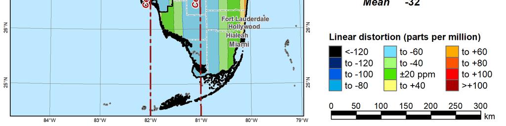
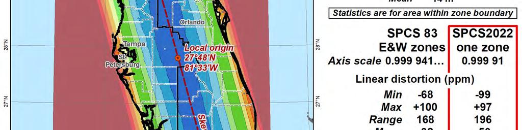
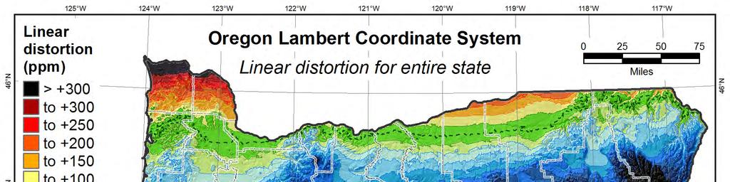
29 Definitions in Policy & Procedures Stakeholders. State organizations that can give input on SPCS2022: DOTs, GIS offices, surveying & engineering societies, professional geospatial organizations, and universities that perform geospatial education or research. Contributing partners. Organizations or individuals that design SPCS2022 zones for stakeholders and in cooperation with NGS. Zone. The region where a projected coordinate system is used. Linear distortion. Amount a map projection distance differs from true horizontal distance at the ground surface. Conformal map projection. Linear distortion is unique (same in every direction) at a point. Projection axis. The line along which linear distortion is minimum and constant with respect to the reference ellipsoid.
30 Linear distortion magnitudes ppm = parts per million (mm/km) ±20 ppm = 2 cm/km = 0.1 ft/mile = 1 : 50,000 Often used as low distortion design criterion (at ground) ±50 ppm = 5 cm/km = 0.3 ft/mile = 1 : 20,000 Minimum design criterion for SPCS2022 designs by NGS (at ground) ±100 ppm = 10 cm/km = 0.5 ft/mile = 1 : 10,000 Nominal maximum State Plane value (on ellipsoid) Can be much greater at topo surface ±400 ppm = 40 cm/km = 2.1 ft/mile = 1 : 2,500 Maximum design criterion for SPCS2022 zones (at ground) Maximum UTM value (on ellipsoid) Nominaldistortion criterion (on ellipsoid) for SPCS 27 and 83 zones (although greatly exceeded for some zones in SPCS 83).
31 Linear distortion with respect to topographic surface Topographic surface Projection axis Horizontal ground distance > ellipsoid distance and > grid distance Projection surface (secant) Ellipsoid surface Ellipsoid distance Grid distance > ellipsoid distance < ground distance This design approach used for SPCS 27 and 83 (minimizes distortion with respect to ellipsoid) Ellipsoid distance Grid distance < ellipsoid distance < ground distance
32 Linear distortion with respect to topographic surface Topographic surface Projection axis Horizontal ground distance > ellipsoid distance and > grid distance Ellipsoid Projection surface surface (nonintersecting) Ellipsoid distance Grid distance > ellipsoid distance ground distance This design approach will be used for SPCS2022 (minimizes distortion with respect to topography)
 Projection surface 255 km (158 miles) Projection surface Ellipsoid surface Max SPCS2022 distortion; also UTM zone width")
33 Zone widths for distortion due to curvature Nominal SPCS 83 and 27 zone width ±100 ppm (±0.5 ft/mile) Projection surface 255 km (158 miles) Projection surface Ellipsoid surface Max SPCS2022 distortion; also UTM zone width ±400 ppm (±2.1 ft/mile) 508 km (316 miles)


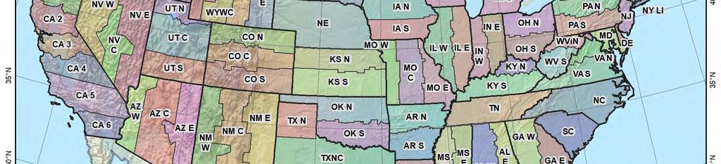
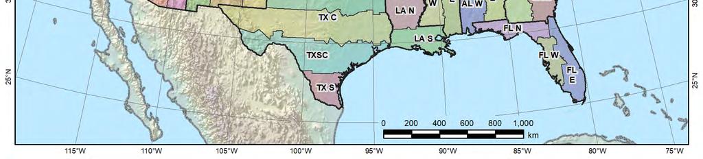
34 Default SPCS2022 would look a lot like SPCS 83
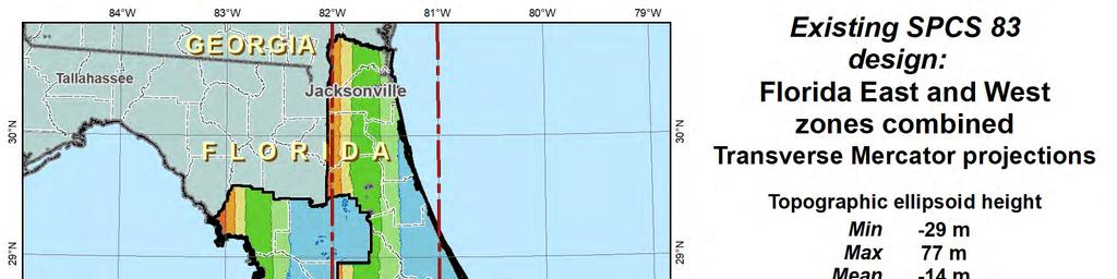
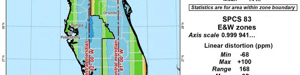
35


36 Change projection type and replace two zones with one
37 5 ppm 0.5 cm/km ft/mile 1:200, ppm 1 cm/km 0.05 ft/mile 1:100, ppm 2 cm/km 0.1 ft/mile 1:50, ppm 5 cm/km 0.3 ft/mile 1:20, ppm 10 cm/km 0.5 ft/mile 1:10, ppm 20 cm/km 1.1 ft/mile 1:5, ppm 40 cm/km 2.1 ft/mile 1:2,500
38 Linear distortion with respect to topographic surface Topographic surface Projection axis Horizontal ground distance > ellipsoid distance and > grid distance Projection surface (secant) Ellipsoid surface Ellipsoid distance Grid distance > ellipsoid distance < ground distance This design approach used for SPCS 27 and 83 (minimizes distortion with respect to ellipsoid) Ellipsoid distance Grid distance < ellipsoid distance < ground distance
39 Statewide and layered zones Policy III.A.2. Limitations Max of TWO layers: Statewide and sub-zones If two layers, one MUST be statewide Minimum subzone dimension > 50 km States often want statewide and small zones Statewide: Single geometry required for state GIS Sub-zones: Lower distortion for surveying/engineering Accommodates state needs, but with restrictions Prevent poor design choices for statewide zones
40
41
42

43
44 What Can You Do to Get Ready for 2022? Understand the magnitude of changing positions and heights for your clients and community Watch for upcoming NGS status reports/webinars Watch for upcoming NGS status reports/webinars NGS plans on new State Plane Coordinates using the same geometric parameters as NAD83 (mostly)

45 What Can You Do to Get Ready for 2022?

.")
46 What Can You Do to Get Ready for 2022? Videos several very good 1 hour videos on Datums, Surfaces, and the new 2022 Datum change presented by Dr. David Doyle, retired chief of the National Geodetic Survey (NGS). Geospatial Users Group search for Geospatial Users Group

47 What Can You Do to Get Ready for 2022? Communicate your issues directly to NGS NGS Local Regional Advisor -
48 Randy Tompkins, PSM, PLS Geomatics Project Manager Surveyor, Hydrographer, & Geodesist DRMP, Inc. Jacksonville, FL (904) Education Bachelor of Science in Geomatics, University of Florida, (1999). Licensure FL Professional Surveyor and Mapper #6503 North Carolina Professional Land Surveyor #5042 Memberships Society of American Military Engineers Geospatial Working Group (SAME) Florida Surveying and Mapping Society (FSMS) Board of Directors 2016 to Present Geospatial Users Group (FSMS) The American Association of Geodetic Surveying (AAGS) The Hydrographic Society of America (THSOA) National Society of Professional Surveyors (NSPS)
NATRF 2022 AND LDP OCTOBER 11, 2017
 NATRF 2022 AND LDP OCTOBER 11, 2017 MODERNIZATION OF THE NSRS Why? Leaving passive control marks behind and relying solely on the CORS network for 3D positions: Older methodology relies on terrestrial
MODERNIZATION OF THE NSRS
 NATRF 2022 AND LDP SEPTEMBER 12, 2017 MODERNIZATION OF THE NSRS Why? Leaving passive control marks behind and relying solely on the CORS network for 3D positions: Older methodology relies on terrestrial
New Datums: Replacing NAVD 88 and NAD 83
 New Datums: Replacing NAVD 88 and NAD 83 By Dave Zenk PE, LS National Geodetic Survey Northern Plains Regional Advisor 1735 Lake Drive West Chanhassen, MN 55317-8581 952-368-2548 office 612-414-9522 mobile
NGS and the Modernization of the National Spatial Reference System (NSRS)
") NGS and the Modernization of the National Spatial Reference System (NSRS) Dr. Dana Caccamise Pacific Southwest Region (CA,NV) Geodetic Advisor dana.caccamise@noaa.gov NOAA s National Geodetic Survey geodesy.noaa.gov
NGS and the Modernization of the National Spatial Reference System (NSRS) Dr. Dana Caccamise Pacific Southwest Region (CA,NV) Geodetic Advisor dana.caccamise@noaa.gov NOAA s National Geodetic Survey geodesy.noaa.gov
U.S. Datums: Where We ve Been,
 U.S. Datums: Where We ve Been, Where We re Going Modernizing the National Spatial Reference System Matt Wellslager RFA, South Carolina Geodetic Survey Presentation Outline 1. - Introductions. 2. - National
The U.S. National Spatial Reference System in 2022
 Presented at the, May 29 - June 2, 2017 in The U.S. National Spatial Reference System in 2022 Daniel R. Roman, (Chief Geodesist) NOAA s National Geodetic Survey 1 Why change? Outline Naming conventions
Changes are coming NGS NSRS Modernization Are you Ready?
 Changes are coming NGS 2022 - NSRS Modernization Are you Ready? Pam Fromhertz Rocky Mountain Regional Advisor Pamela.Fromhertz@noaa.gov 240-988-6363 John Hunter CO State Geomatics Coordinator DRCOG March
Frames for the Future New Datum Definitions for Modernization of the U.S. National Spatial Reference System
 Figure 10. Horizontal position differences (in meters) between NAD 83 and ITRF 08 at time 2022.00 (January 1, 2022). Positional differences are shown for the North American and Pacific tectonic plates.
New Datums: Replacing NAVD 88 and NAD 83
 New Datums: Replacing NAVD 88 and NAD 83 Professional Surveyors Association of Nebraska Winter Seminar Dave Zenk NGS Advisor February 9, 2018 Kearney, NE February 9, 2018 Professional Surveyors Association
MSGIC Spring Mtg Denton April 23, 2014
 Modernization of the National Spatial Reference System Keeping Pace with Changes in Positioning Technology and User Expectations in a Dynamic World MSGIC Spring Mtg Denton April 23, 2014 Dave Doyle Base
Positioning a nation for the future: Modernizing the United States National Spatial Reference System
 Positioning a nation for the future: Modernizing the United States National Spatial Reference System Dr. Dana Caccamise USA Representative Pacific Southwest Region Geodetic Advisor dana.caccamise@noaa.gov
BUILDING AN ACCURATE GIS
 BUILDING AN ACCURATE GIS 2006 GIS in the Rockies Denver, Colorado September 13, 2006 William E. Linzey United States Department of Commerce National Oceanic and Atmospheric Administration National Geodetic
NGS is Scheduled to Replace NAVD 88 and NAD 83 In 2022
 NGS is Scheduled to Replace NAVD 88 and NAD 83 In 2022 Indiana Society of Professional Land Surveyors Conference January 2017 John Ellingson NGS Geodetic Advisor john.ellingson@noaa.gov 202-306-6904 1
Ground Truth Annual Conference. Optimized Design of Low Distortion Projections. Michael L. Dennis, RLS, PE
 Arizona Professional Land Surveyors Association 016 Annual Conference Ground Truth Optimized Design of Low Distortion Projections Michael L. Dennis, RLS, PE Version 3 (rev 1), May 016 Design and metadata
ch02.pdf chap2.pdf chap02.pdf
 Introduction to Geographic Information Systems 8th Edition Karl Solutions Manual Full Download: http://testbanklive.com/download/introduction-to-geographic-information-systems-8th-edition-karl-solutions-manu
Positioning the Pacific: NOAA s Geospatial Activities. Juliana Blackwell, Director NOAA s National Geodetic Survey March 6, 2012
 Positioning the Pacific: NOAA s Geospatial Activities Juliana Blackwell, Director NOAA s National Geodetic Survey March 6, 2012 A Common Problem of the Early 19 th Century 1807 President Thomas Jefferson
The National Spatial Reference System of the Future
 The National Spatial Reference System of the Future William Stone Southwest Region (AZ, NM, NV, UT) Geodetic Advisor william.stone@noaa.gov NOAA s National Geodetic Survey geodesy.noaa.gov Salt Lake City
Ground Truth Annual Conference. Design and Documentation of Low Distortion Projections for Surveying and GIS
 Professional Land Surveyors of Oregon 15 Annual Conference Ground Truth Design and Documentation of Low Distortion Projections for Surveying and GIS Michael L Dennis, RLS, PE v. (rev 1), January 15, Design
4 Survey Datums. 4.1 Horizontal Datum Policy SURVEY DATUMS SEPTEMBER 2006
 4 Survey Datums Today s multi-organizational Project Development efforts require the use of common, accurate horizontal and vertical survey datums and consistent, precise control-survey procedures to ensure
The Future of SPCS in Charles Chuck Ghilani, Ph.D. Professor Emeritus Pennsylvania State University
 The Future of SPCS in 2022 Charles Chuck Ghilani, Ph.D. Professor Emeritus Pennsylvania State University Class Etiquette Turn off all cell phones Or set them to vibrate Go out of the room to answer any
WHERE ARE YOU? Maps & Geospatial Concepts Fall 2015
 WHERE ARE YOU? Maps & Geospatial Concepts Fall 2015 Where are you? Relative location I m at school Absolute Location 45 26 18.07 122 43 50.78 Where is Boston? Introducing Geodesy, Ellipsoids & Geoids Geodesy
GISC3325 Spring 2011 Final Exam
 GISC3325 Spring 2011 Final Exam Name: Carefully read each question. Identify the important elements and the question being asked. Show your work for partial credit. No credit for undocumented wrong answers.
Control Surveys and Coordinate Systems
 Control Surveys and Coordinate Systems The Earth is Round Basic Shape of the Earth: Oblate Spheroid of Revolution The length of the equatorial axis is approximately 27 miles greater than the polar axis.
VT State Plane. Daniel J. Martin National Geodetic Survey VT Geodetic Advisor. VSLS Conference Rutland VT April 11, 2008
 VT State Plane Daniel J. Martin National Geodetic Survey VT Geodetic Advisor VSLS Conference Rutland VT April 11, 2008 Today s Outline Define the problem Review of VT State Plane System Relationship
Fusion of Geodesy and GIS at NOAA s National Geodetic Survey
 Fusion of Geodesy and GIS at NOAA s National Geodetic Survey Esri Survey Summit July 6-9, 2013 San Diego, CA Michael Dennis, RLS, PE michael.dennis@noaa.gov The Plan Background NGS Data Explorer New Datasheet
A PRIMER ON COORDINATE SYSTEMS Commonly Used in Michigan
 A PRIMER ON COORDINATE SYSTEMS Commonly Used in Michigan David P. Lusch, Ph.D., GISP Department of Geography Remote Sensing & GIS Research and Outreach Services Group Michigan State University September,
HORIZONTAL PROJECTION PARAMETERS: DANE COUNTY COORDINATES
 Recommended RTK GPS Configuration Parameters for the City of Madison, WI Base Station Compiled by: Dan Rodman RLS, City of Madison (608)266-6674 drodman@cityofmadison.com For base station information see
Solving the "Grid to Ground Problem" with Custom Coordinate Systems CV327-6 About the Speaker:
 Solving the "Grid to Ground Problem" with Custom Coordinate Systems Richard Sincovec, LSI Director of Technology, Edward James Surveying President, Quux Software CV327-6 Grid projections such as the State
This week s topics. Week 6. FE 257. GIS and Forest Engineering Applications. Week 6
 FE 257. GIS and Forest Engineering Applications Week 6 Week 6 Last week Chapter 8 Combining and splitting landscape features and merging GIS databases Chapter 11 Overlay processes Questions? Next week
The 3-D Global Spatial Data Model: Geometrical Foundation of the Global Spatial Data Infrastructure
 The 3-D Global Spatial Data Model: Geometrical Foundation of the Global Spatial Data Infrastructure Earl F. Burkholder, PS, PE Annotated Table of Contents July 8,2006 I. The Global Spatial Data Model (GSDM)
Session description and objectives
 Journey to the Moving Center of the Earth The Evolution of the National Spatial Reference System NJSPLS SurvCon 2018 January 31, 2018 Dan Martin Northeast Regional Geodetic Advisor ME, NH, VT, MA, CT,
Town of Chino Valley. Survey Control Network Report. mgfneerhg mc N. Willow Creek Road Prescott AZ
 Town of Chino Valley Survey Control Network Report mgfneerhg mc. 2050 N. Willow Creek Road Prescott AZ 86301 928-771-2376 Page 1 of 70 Table of Contents Town of Chino Valley Survey Datum Outline A short
The Future of SPCS in 2022
 The Future of SPCS in 2022 Charles Chuck Ghilani, Ph.D. Professor Emeritus Pennsylvania State University Class Etiquette Turn off all cell phones Or set them to vibrate Go out of the room to answer any
Making Sense of Evolving Reference Frames for North America
 Making Sense of Evolving Reference Frames for North America Mike Craymer Geodetic Survey Division, Natural Resources Canada Giovanni Sella U.S. National Geodesy Survey American Geophysical Union 2007 Joint
WHERE ARE YOU? Maps & Geospatial Concepts Fall 2012
 WHERE ARE YOU? Maps & Geospatial Concepts Fall 2012 Where are you? Relative location I m at school Absolute Location 45 26 18.07 122 43 50.78 Datums Datums A reference surface of the Earth Used as the
GEOID UNDULATIONS OF SUDAN USING ORTHOMETRIC HEIGHTS COMPARED WITH THE EGM96 ANG EGM2008
 GEOID UNDULATIONS OF SUDAN USING ORTHOMETRIC HEIGHTS COMPARED Dr. Abdelrahim Elgizouli Mohamed Ahmed* WITH THE EGM96 ANG EGM2008 Abstract: Positioning by satellite system determine the normal height above
Spatial Data Collection using GPS: BEST PRACTICES
 Spatial Data Collection using GPS: BEST PRACTICES - 2007 Page 1 of 10 Best practices for GPS & Spatial Data Collection, Storage and Documentation These Best Practices are designed to maximize positional
Intro to GIS Fall 2010 Georeferencing & Map Projections
 Intro to GIS Fall 2010 Georeferencing & Map Projections SHAPE OF THE EARTH Earth's Shape Geoid: shape of earth minus topographic features (irregular due to local variations in gravity) Ellipsoid: elongated
Analytical and Computer Cartography Lecture 3: Review: Coordinate Systems
 Analytical and Computer Cartography Lecture 3: Review: Coordinate Systems Geographic Coordinates NAD83 NAD27 remained in use until the earthcentered international GRS80 was complete (Geodetic Reference
What is a Map Projection?
 What is a Map Projection? It is how we represent a three dimensional Earth on a flat piece of paper However The process of transferring information from the Earth to a map causes every projection to distort
Coordinate Systems and Datum Transformation in ArcGIS. Brittney White and Melita Kennedy
 Coordinate Systems and Datum Transformation in ArcGIS Brittney White and Melita Kennedy Where is my data? Problem Horizontal Vertical Projections Transformations Horizontal coordinate systems Geographic
Vertical Reference Frame Pacific
 Vertical Reference Frame Pacific Andrick Lal SPC Geoscience Division GIS&RS User Conference 29 th November 2016 USP, Fiji. What does it mean? All buildings and features have a height. But what is it relative
The U.S. National Spatial Reference System in 2022
 The U.S. National Spatial Reference System in 2022 Daniel ROMAN, U.S.A. Key words: Capacity Building; GNSS/GPS; Legislation; Positioning; Reference Frames; Reference Systems; Standards SUMMARY In 2022,
Height systems. Rudi Gens Alaska Satellite Facility
 Rudi Gens Alaska Satellite Facility Outline Why bother about height systems? Relevant terms Coordinate systems Reference surfaces Geopotential number 2 Why bother about height systems? give a meaning to
Lecture 10-14: Map Projections and Coordinate System
 URP 1281 Surveying and Cartography Lecture 10-14: Map Projections and Coordinate System December 27, 2015 Course Teacher: Md. Esraz-Ul-Zannat Assistant Professor Department of Urban and Regional Planning
Achieving Great Height with GNSS
 Achieving Great Height with GNSS Oregon GPS Users Group 2015 Annual Meeting January 23, 2015 Salem, Oregon Salem Convention Center Michael Dennis, RLS, PE Oregon State University National Geodetic Survey
Update on GRAV-D and Progress toward a new vertical Datum
 Update on GRAV-D and Progress toward a new vertical Datum New York Association of Professional Land Surveyors January 17, 201 Dan Martin Northeast Regional Geodetic Advisor ME, NH, VT, MA, CT, RI, NY,
United States NSRS 2022: Terrestrial Reference Frames
 United States NSRS 2022: Terrestrial Reference Frames Daniel ROMAN, U.S.A. Key words: Capacity building; Positioning; Reference frames; Reference systems, Cadastre SUMMARY In 2022, the United States will
12/26/2012. Geographic Information Systems * * * * GIS (... yrezaei
 ( - Geographic Information Systems ( ( 1 2 3 Information System Data base DB IS IS DB (Knowledge ( ( (System (Information System - (Georefrence Analysis Data + Knowledge ======== Information 4 5 ( < 10%
CHAIRMAN OF THE JOINT CHIEFS OF STAFF INSTRUCTION
 CHAIRMAN OF THE JOINT CHIEFS OF STAFF INSTRUCTION J-3 CJCSI 3900.01C DISTRIBUTION: A, B, C, J POSITION (POINT AND AREA) REFERENCE PROCEDURES Reference: DODD 5105.60, 11 October 1996, National Imagery and
Introduction to Geographic Information Science. Updates/News. Last Lecture. Geography 4103 / Map Projections and Coordinate Systems
 Geography 4103 / 5103 Introduction to Geographic Information Science Map Projections and Coordinate Systems Updates/News Thursday s lecture Reading discussion 1 find the readings online open questions,
GPS Surveying Dr. Jayanta Kumar Ghosh Department of Civil Engineering Indian Institute of Technology, Roorkee. Lecture 06 GPS Position
 GPS Surveying Dr. Jayanta Kumar Ghosh Department of Civil Engineering Indian Institute of Technology, Roorkee Lecture 06 GPS Position Friends! Welcome you to sixth class on GPS surveying. Today, I am going
EnvSci360 Computer and Analytical Cartography
 EnvSci360 Computer and Analytical Cartography Lecture 3 Geodesy Map Projections, Datums, and Coordinate Systems 1 Geodesy The science of measuring and representing the shape and size of the earth, and
Understanding Projections for GIS
 Presented by John Schaeffer Juniper GIS Services, Inc. This PowerPoint is available at JuniperGIS.com Presentation Objectives To understand basic concepts on projections and coordinate systems for the
Georeferencing, Map Projections, Cartographic Concepts. -Coordinate Systems -Datum
 Georeferencing, Map Projections, Cartographic Concepts -Map Projections -Coordinate Systems -Datum Map projection is "the process of systematically transforming positions on the Earth's spherical surface
Georeferencing. Place names Postal addresses Postal codes Coordinate systems (lat/long, UTM, etc.)
") Georeferencing Georeferencing Used to describe the act of assigning locations to data or information Certain requirements include that they are: unique, have shared meaning, and are persistent through
Georeferencing Georeferencing Used to describe the act of assigning locations to data or information Certain requirements include that they are: unique, have shared meaning, and are persistent through
Shape of the Earth. Data Output by the Receiver
 It is quite common for confusion to arise about the process used during a hydrographic survey when GPS-derived water surface elevation is incorporated into the data as an RTK Tide correction. This article
Geographic Information Systems class # 1 February 19, Coordinate reference systems in GIS: geodetic coordinates
 Geographic Information Systems class # 1 February 19, 2013 Coordinate reference systems in GIS: geodetic coordinates Manuel Campagnolo ISA Manuel Campagnolo (ISA) GIS/SIG 2012 2013 February 19, 2013 1
NR402 GIS Applications in Natural Resources Lesson 4 Map Projections
 NR402 GIS Applications in Natural Resources Lesson 4 Map Projections From http://www.or.blm.gov/gis/ 1 Geographic coordinates Coordinates are expressed as Latitude and Longitude in Degrees, Minutes, Seconds
Lecture 4. Coordinate Systems & Projections
 Lecture 4 Coordinate Systems & Projections Outline Geodesy Geoids Ellipsoids Geographic Coordinate Systems Magnetic North vs. True North Datums Projections Applying Coordinate Systems and Projections Why
ERTH 455 / GEOP 555 Geodetic Methods. Lecture 04: GPS Overview, Coordinate Systems
 ERTH 455 / GEOP 555 Geodetic Methods Lecture 04: GPS Overview, Coordinate Systems Ronni Grapenthin rg@nmt.edu MSEC 356 x5924 August 30, 2017 1 / 22 2 / 22 GPS Overview 1973: Architecture approved 1978:
April 24, :00 to 5:00 p.m.
 Datums, Coordinate Systems, Low Distortion Projections (LDP), & the Global Spatial Data Model (GSDM) Hosted by: City of Las Cruces Public Works/Project Development and Community Development/GIS April 24,
GEOGRAPHIC COORDINATE SYSTEMS
 GEOGRAPHIC COORDINATE SYSTEMS Introduction to GIS Winter 2015 What is Georeferencing? Used to establish a location on the Earth s surface 1 st order polynomial transformation Georeferencing toolbar What
Boolean Operators and Topological OVERLAY FUNCTIONS IN GIS
 Boolean Operators and Topological OVERLAY FUNCTIONS IN GIS Query asking a question of the attribute data Standard Query Language (SQL) is used to query the data There are 4 basic statements used to get
Downloaded from MILITARY STANDARD DEPARTMENT OF DEFENSE WORLD GEODETIC SYSTEM (WGS)
") METRIC 11 JANUARY 1994 MILITARY STANDARD DEPARTMENT OF DEFENSE WORLD GEODETIC SYSTEM (WGS) AMSC N/A AREA MCGT DISTRIBUTION STATEMENT A. Approved for public release; distribution is unlimited. FOREWORD
METRIC 11 JANUARY 1994 MILITARY STANDARD DEPARTMENT OF DEFENSE WORLD GEODETIC SYSTEM (WGS) AMSC N/A AREA MCGT DISTRIBUTION STATEMENT A. Approved for public release; distribution is unlimited. FOREWORD
Map projections. Rüdiger Gens
 Rüdiger Gens Coordinate systems Geographic coordinates f a: semi-major axis b: semi-minor axis Geographic latitude b Geodetic latitude a f: flattening = (a-b)/a Expresses as a fraction 1/f = about 300
Shape e o f f the e Earth
 1 Coordinate Systems & Projections Coordinate Systems Two map layers are not going to register spatially unless they are based on the same coordinate system. 2 Contents Shape of the earth Datum Projections
HP-33S Calculator Program TM 2
 Convert Latitude and Longitude to Transverse Mercator Co-ordinates (UTM, SPCS, etc.) Programmer: Dr. Bill Hazelton Date: April, 2008. Version: 1.0 Mnemonic: T for Transverse Mercator Line Instruction Display
HP-35s Calculator Program TM 1
 Convert Latitude and Longitude to Transverse Mercator Co-ordinates (UTM, SPCS, etc.) Programmer: Dr. Bill Hazelton Date: April, 2008. Version: 1.0 Mnemonic: T for Transverse Mercator Line Instruction Display
UNITED NATIONS E/CONF.97/6/IP. 33
 UNITED NATIONS E/CONF.97/6/IP. 33 ECONOMIC AND SOCIAL COUNCIL Seventeenth United Nations Regional Cartographic Conference for Asia and the Pacific Bangkok, 18-22 September 2006 Item 7 of the provisional
How does an ellipsoid differ from a sphere in approximating the shape and size of the Earth?
 Chapter 02 Test Bank Worksheet Questions 1. What is a map projection? Topic: Map Projection 2. How does an ellipsoid differ from a sphere in approximating the shape and size of the Earth? Topic: Ellipsoid
Precise Hong Kong Geoid HKGEOID-2000
 Yong-Qi Chen 1, Zhicai Luo 1 and Simon Kwok 2 1.Department of Land Surveying and Geo-Informatics, The Hong Kong olytechnic University 2 Geodetic Survey Section, Lands Department, HKSAR Abstract: This paper
You might know your position precisely but do you know where you are?
 You might know your position precisely but do you know where you are? Whosoever wishes to know about the world must learn about it in its particular details. The possession of knowledge does not kill the
Map Projections. What does the world look like? AITOFF AZIMUTHAL EQUIDISTANT BEHRMANN EQUAL AREA CYLINDRICAL
 Map Projections What does the world look like? AITOFF AZIMUTHAL EQUIDISTANT BEHRMANN EQUAL AREA CYLINDRICAL 1 CYLINDRICAL EQUAL AREA BONNE CRASTER PARABOLIC 2 ECKERT I ECKERT III ECKERT V There are many
SPCS2022 in North Carolina
 SPCS2022 in North Carolina New State Plane Coordinate System in 2022 Will replace SPCS 83 Referenced to new terrestrial reference frames Two conflicting desires for SPCS2022 coordinates: Change coordinates
Updating and Re-establishment of Cadastral Control Points in Korea by Using GPS Observations
 Updating and Re-establishment of Cadastral Control Points in Korea by Using GPS Observations YANG Chul-Soo, Korea Key words: GPS, cadastral control point, datum transformation, network adjustment SUMMARY
ELECTRONICS DIVISION INTERNAL REPORT NO. 324
 NATIONAL RADIO ASTRONOMY OBSERVATORY Green Bank, West Virginia ELECTRONICS DIVISION INTERNAL REPORT NO. 324 NRAO 43m Antenna Coordinates and Angular Limits (Version 4) Glen Langston September 14, 2012
GRAV-D. Gravity for the Re-definition of the American Vertical Datum
 GRAV-D Gravity for the Re-definition of the American Vertical Datum Why this briefing? NGS recently acquired a new airborne gravimeter Intended to support GRAV-D GRAV-D is an ambitious new plan for NGS
Proceedings of the First International Conference on Civil Engineering, Assiut University, Volume 2, pp , October 7-8.
 Proceedings of the First International Conference on Civil Engineering, Assiut University, Volume 2, pp. 246-253, October 7-8. PRODUCTIVE GPS TOPOGRAPHIC MAPPING FOR NATIONAL DEVELOPMENT PROJECTS IN EGYPT
TOWARDS ROBUST LOCALIZATION OF RTK-GPS TOPOGRAPHIC SURVEYS 23
 TOWARDS ROBUST LOCALIZATION OF RTK-GPS TOPOGRAPHIC SURVEYS Jerry W. Nave, North Carolina A&T University; Tarig A. Ali, American University of Sharjah Abstract Localization is performed to fit the observed
Spatial Reference Systems. Introduction
 Spatial Reference Systems Wolfgang Kainz Professor of Cartography and Geoinformation Department of Geography and Regional Research University of Vienna wolfgang.kainz@univie.ac.at Introduction Historic
GPS and Mean Sea Level in ESRI ArcPad
 Summary In order to record elevation values as accurately as possible with, it is necessary to understand how ArcPad records elevation. Rather than storing elevation values relative to Mean Sea Level (MSL),
Lesson 5: Map Scale and Projections
 Organizing Data and Information Lesson 5: Map Scale and Projections Map Scales Projections Information can be organized as lists, numbers, tables, text, pictures, maps, or indexes. Clusters of information
GEOIDS FAQ. November
 GEOIDS FAQ 1. What is a geoid? A geoid is a representation of the equipotential surface of the Earth s gravity field. It can be thought of as a surface coinciding with the undisturbed mean sea level extended
GPS Remote Sensing. GIS Photogrammetry. GEODESY Equipment (total station) CARTOGRAPHY Survey Software. Map Projection Coordinate Systems
 CARTOGRAPHY Survey Software. Map Projection Coordinate Systems") GPS Remote Sensing GIS Photogrammetry GEODESY Equipment (total station) CARTOGRAPHY Survey Software Map Projection Coordinate Systems 1 Coordinate Systems, Datum and Map Projection Dr. Maher A. El-Hallaq
GPS Remote Sensing GIS Photogrammetry GEODESY Equipment (total station) CARTOGRAPHY Survey Software Map Projection Coordinate Systems 1 Coordinate Systems, Datum and Map Projection Dr. Maher A. El-Hallaq
Map Projections. Displaying the earth on 2 dimensional maps
 Map Projections Displaying the earth on 2 dimensional maps Map projections Define the spatial relationship between locations on earth and their relative locations on a flat map Are mathematical expressions
Positioning in the Pacific Islands
 Positioning in the Pacific Islands Andrick Lal United Nations/Nepal Workshop on the Applications of Global Navigation Satellite Systems Kathmandu - Nepal 15 th December 2016 Presentation Outline Introduction
Projections & GIS Data Collection: An Overview
 Projections & GIS Data Collection: An Overview Projections Primary data capture Secondary data capture Data transfer Capturing attribute data Managing a data capture project Geodesy Basics for Geospatial
Week 02. Assist. Prof. Dr. Himmet KARAMAN
 Week 02 Assist. Prof. Dr. Himmet KARAMAN Contents Satellite Orbits Ephemerides GPS Review Accuracy & Usage Limitation Reference Systems GPS Services GPS Segments Satellite Positioning 2 Satellite Orbits
Geodetics: Implications for GIS Professionals May 10, 2018
 Experts in Geomatics, Surveying, Positioning, Geospatial Data, and Mapping Sciences Geodetics: Implications for GIS Professionals May 10, 2018 Michael Barnes APSG Education Foundation Chair 2010-2020 APSG
Inclusion of Leveling with GNSS Observations in a Single, 3-D Geodetic Survey Network Adjustment. Daniel GILLINS, U.S.A., and Michael DENNIS, U.S.A.
 Inclusion of Leveling with GNSS Observations in a Single, 3-D Geodetic Survey Network Adjustment Daniel GILLINS, U.S.A., and Michael DENNIS, U.S.A. Key words: Leveling, Integrated Geodesy, Geoid Accuracy,
Positional Accuracy of the Google Earth Imagery In The Gaza Strip
 Positional Accuracy of the Google Earth Imagery In The Gaza Strip Maher A. El-Hallaq Associate Professor of Surveying Civil Engineering Department The Islamic University of Gaza, Palestine mhallaq@iugaza.edu.ps
SOURCE: NAVD88 (Computed using GEOID12B)
") Shared Solution https://www.ngs.noaa.gov/opus/getdatasheet.jsp?pid=... 1 of 1 10/2/2018, 2:52 PM Shared Solution PID: Designation: NYKT R1 Stamping: NYKT R1 2005 Stability: May hold commonly subject to
Shared Solution https://www.ngs.noaa.gov/opus/getdatasheet.jsp?pid=... 1 of 1 10/2/2018, 2:52 PM Shared Solution PID: Designation: NYKT R1 Stamping: NYKT R1 2005 Stability: May hold commonly subject to
Evaluation of GPS in Orthometric Heights Determination in Khartoum State (Sudan)
") Evaluation of GPS in Orthometric Heights Determination in Khartoum State (Sudan) Dr. Nagi Zomrawi Mohammed 1, Dr. Abd Elrahim Elgizouli Mohammed 2 and Engineer Osman Bakry 3 1 Sudan University of Science
Evaluation of GPS in Orthometric Heights Determination in Khartoum State (Sudan) Dr. Nagi Zomrawi Mohammed 1, Dr. Abd Elrahim Elgizouli Mohammed 2 and Engineer Osman Bakry 3 1 Sudan University of Science
1. Geospatial technology rarely links geospatial data to nonspatial data. a. True *b. False
 Chapter 2 Where in the Geospatial World Are You? 1. Geospatial technology rarely links geospatial data to nonspatial data. 2. For geospatial technology to work, every location on Earth must be: a. inhabited
Geo Referencing & Map projections CGI-GIRS 0910
 Geo Referencing & Map projections CGI-GIRS 0910 Where are you? 31UFT8361 174,7 441,2 51 58' NB 5 40' OL 2/60 Who are they? 3/60 Do geo data describe Earth s phenomena perfectly? Georeference systems ellipsoid
Ellipsoid Hydro Datum Geoid Errors
 Ellipsoid Hydro Datum Geoid Errors Jack L. Riley Office of Coast Survey Hydrographic Systems & Technology Branch Geoid Errors via Ellipsoid Hydrography? Per datum hydro Traditional & ellipsoid referenced
What is Geodesy? Types of Geodesy terrestrial or classical geodesy space geodesy theoretical geodesy
 What is Geodesy? Geodesy is the study of: The size, shape and motion of the earth The measurement of the position and motion of points on the earth's surface, and The study of the earth's gravity field
Fundamentals of Surveying (LE/ESSE )
") Fundamentals of Surveying (LE/ESSE 2620 3.0) Lecture 2 Basics of Surveying Dr.-Ing. Jian-Guo Wang Geomatics Engineering York University Fall 2017 1 2-1. Overview Part 1: Basics - The Earth s Shape & Size.
Fundamentals of Surveying (LE/ESSE 2620 3.0) Lecture 2 Basics of Surveying Dr.-Ing. Jian-Guo Wang Geomatics Engineering York University Fall 2017 1 2-1. Overview Part 1: Basics - The Earth s Shape & Size.
Geo Referencing & Map projections CGI-GIRS 0910
 Geo Referencing & Map projections CGI-GIRS 0910 Where are you? 31UFT8361 174,7 441,2 51 58' NB 5 40' OL 2/60 Who are they? 3/60 Do geo data describe Earth s phenomena perfectly? Georeference systems ellipsoid