The National Spatial Reference System of the Future
|
|
|
- Logan Cooper
- 5 years ago
- Views:
Transcription
1 The National Spatial Reference System of the Future William Stone Southwest Region (AZ, NM, NV, UT) Geodetic Advisor NOAA s National Geodetic Survey geodesy.noaa.gov Salt Lake City November 13, 2013
2 U.S. Department of Commerce National Oceanic & Atmospheric Administration National Geodetic Survey Mission: To define, maintain & provide access to the National Spatial Reference System (NSRS) to meet our Nation s economic, social & environmental needs National Spatial Reference System Latitude Longitude Height Scale Gravity Orientation & their time variations (& geoid models, satellite orbits transformation tools, etc.) $2.5B / year benefit
3 LiDAR Digital Terrain Model Aerial Photography Cartography Parcels Engineering Laser Scan Model Satellite Imagery Hydrography Natural Resources Flood Risk National Spatial Reference System - Ties It All Together Horizontal / Vertical Geodetic Control (National Spatial Reference System) NAVD88 NAD83


4 A (very) Brief History of U.S. Horizontal / Geometric Datums shift: < 10 m tens of few few few (1-2 meters 0.1m 0.01m 0.01m meters) time
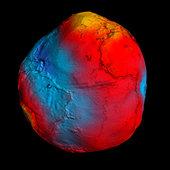
5

")

6 Continuously Operating Reference Station (CORS) Network q 1950 sites q 225 organizations

")
7 CORS Velocity Field: NAD83(2011) epoch

8 CORS Velocity Field: International Terrestrial Reference Frame 2008 ITRF Global Tracking Network
 v By 2022, reduce all definitional & access-related errors in orthometric heights ( elevation ) in geopotential reference frame to 2 cm when using 15 min of GNSS data Replace NAVD88")
9 NGS Ten-Year Strategic Plan: v By 2022, reduce all definitional & access-related errors in geometric reference frame to 1 cm when using 15 min of GNSS data Replace NAD83 (North American Datum 1983) v By 2022, reduce all definitional & access-related errors in orthometric heights ( elevation ) in geopotential reference frame to 2 cm when using 15 min of GNSS data Replace NAVD88 (North American Vertical Datum 1988)


 o CORS")

10 NAD83 Shortcomings o 2.2 m offset NAD 83 vs. ITRF08 (& WGS84) o CORS vs. passive network consistency challenges vs.
")
")
11 Future Geometric (lat, long, eht) Datum by 2022 replace NAD83 defined by Continuously Operating Reference Station (CORS) Network accessed by GNSS observations coordinates & velocities in ITRF & US datum passive control (monuments) tied to new datum

12 New geometric datum minus NAD 83 (horizontal)
")
13 New geometric datum minus NAD 83 (ellipsoid height)


")
14 NORTH AMERICAL VERTICAL DATUM 1988 (NAVD88)
 o 0.")


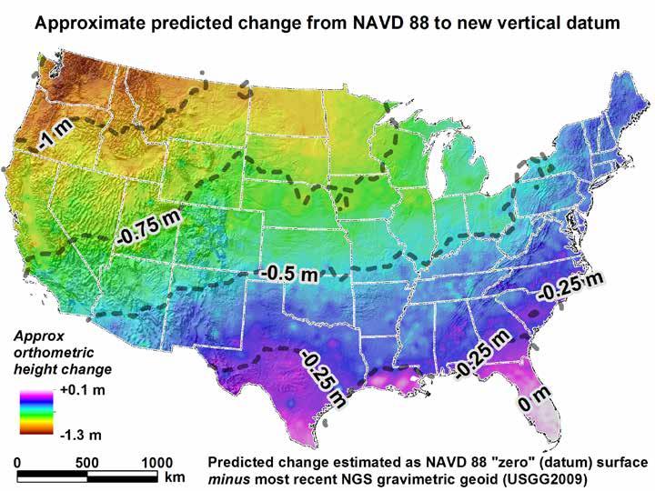
15 NAVD88 Shortcomings o Cross-country errors (1-m tilt) o 0.5 m bias in reference surface vs. global mean sea level geoid o Subsidence, uplift, freeze/thaw invalidate BM elevations Approximate Geoid Mismatch in the NAVD88 H=0 surface
16 Future Geopotential (Vertical) Datum by 2022 replace NAVD88 accessed by GNSS & gravimetric geoid (N) monitor time-varying nature of gravity field most accurate continental gravimetric geoid model, ever
 Replace the US Vertical")


17 Gravity for the Redefinition of the American Vertical Datum (GRAV-D) Replace the US Vertical Datum by 2022 with gravimetric geoid (N) accurate to 1 cm 2 cm accurate orthometric heights via GNSS Airborne gravity survey of entire country Long-term monitoring of geoid change Gravity and Heights are inseparably connected


18 GRAV-D Status (11/2013) 10 km spaced data lines 70 km spaced cross lines 20,000 ft altitude 230 kt flight speed 25% of US complete 2013 flown 2014 planned Green = FY11 and earlier Orange = FY12 White = FY13 Blue = FY14 Plan Filled white = Underway Filled red = Incomplete


19 Gravity field & steady-state Ocean Circulation Explorer (GOCE)
20
21
22 How to Plan for 2022 Move to NAD 83(2011) epoch conversion tools - NADCON, GEOCON & GEOCON11 Move to NAVD 88 conversion tool VERTCON (NGVD29 <> NAVD88) Move from reliance on passive marks to GNSS utilize CORS, OPUS, real-time infrastructure, etc. Use NGS Online Positioning User Service (OPUS) for GPSBMs improve next geoid model & relationship with new datum METADATA!!!!

23 NGS homepage: geodesy.noaa.gov Data access Geodetic Toolkit Publications Height Modernization Training opps Education resources Presentations CORS, OPUS,

24 Mark your calendars
")


25 Find the article(s) in the Archives at:
 Bill Stone q Colorado Pam Fromhertz q Oregon Mark")
26 National Geodetic Survey Geodetic Advisors q SW Region (AZ, NV, NM, UT) Bill Stone q Colorado Pam Fromhertz q Oregon Mark Armstrong


27 Accurate positioning begins with accurate coordinates Source: Zurich-American Insurance Group


28 William Stone geodesy.noaa.gov
NGS and the Modernization of the National Spatial Reference System (NSRS)
") NGS and the Modernization of the National Spatial Reference System (NSRS) Dr. Dana Caccamise Pacific Southwest Region (CA,NV) Geodetic Advisor dana.caccamise@noaa.gov NOAA s National Geodetic Survey geodesy.noaa.gov
NGS and the Modernization of the National Spatial Reference System (NSRS) Dr. Dana Caccamise Pacific Southwest Region (CA,NV) Geodetic Advisor dana.caccamise@noaa.gov NOAA s National Geodetic Survey geodesy.noaa.gov
NGS is Scheduled to Replace NAVD 88 and NAD 83 In 2022
 NGS is Scheduled to Replace NAVD 88 and NAD 83 In 2022 Indiana Society of Professional Land Surveyors Conference January 2017 John Ellingson NGS Geodetic Advisor john.ellingson@noaa.gov 202-306-6904 1
MSGIC Spring Mtg Denton April 23, 2014
 Modernization of the National Spatial Reference System Keeping Pace with Changes in Positioning Technology and User Expectations in a Dynamic World MSGIC Spring Mtg Denton April 23, 2014 Dave Doyle Base
Changes are coming NGS NSRS Modernization Are you Ready?
 Changes are coming NGS 2022 - NSRS Modernization Are you Ready? Pam Fromhertz Rocky Mountain Regional Advisor Pamela.Fromhertz@noaa.gov 240-988-6363 John Hunter CO State Geomatics Coordinator DRCOG March
Positioning the Pacific: NOAA s Geospatial Activities. Juliana Blackwell, Director NOAA s National Geodetic Survey March 6, 2012
 Positioning the Pacific: NOAA s Geospatial Activities Juliana Blackwell, Director NOAA s National Geodetic Survey March 6, 2012 A Common Problem of the Early 19 th Century 1807 President Thomas Jefferson
BUILDING AN ACCURATE GIS
 BUILDING AN ACCURATE GIS 2006 GIS in the Rockies Denver, Colorado September 13, 2006 William E. Linzey United States Department of Commerce National Oceanic and Atmospheric Administration National Geodetic
Frames for the Future New Datum Definitions for Modernization of the U.S. National Spatial Reference System
 Figure 10. Horizontal position differences (in meters) between NAD 83 and ITRF 08 at time 2022.00 (January 1, 2022). Positional differences are shown for the North American and Pacific tectonic plates.
U.S. Datums: Where We ve Been,
 U.S. Datums: Where We ve Been, Where We re Going Modernizing the National Spatial Reference System Matt Wellslager RFA, South Carolina Geodetic Survey Presentation Outline 1. - Introductions. 2. - National
Positioning a nation for the future: Modernizing the United States National Spatial Reference System
 Positioning a nation for the future: Modernizing the United States National Spatial Reference System Dr. Dana Caccamise USA Representative Pacific Southwest Region Geodetic Advisor dana.caccamise@noaa.gov
NATRF 2022 AND LDP OCTOBER 11, 2017
 NATRF 2022 AND LDP OCTOBER 11, 2017 MODERNIZATION OF THE NSRS Why? Leaving passive control marks behind and relying solely on the CORS network for 3D positions: Older methodology relies on terrestrial
MODERNIZATION OF THE NSRS
 NATRF 2022 AND LDP SEPTEMBER 12, 2017 MODERNIZATION OF THE NSRS Why? Leaving passive control marks behind and relying solely on the CORS network for 3D positions: Older methodology relies on terrestrial
GISC3325 Spring 2011 Final Exam
 GISC3325 Spring 2011 Final Exam Name: Carefully read each question. Identify the important elements and the question being asked. Show your work for partial credit. No credit for undocumented wrong answers.
Fusion of Geodesy and GIS at NOAA s National Geodetic Survey
 Fusion of Geodesy and GIS at NOAA s National Geodetic Survey Esri Survey Summit July 6-9, 2013 San Diego, CA Michael Dennis, RLS, PE michael.dennis@noaa.gov The Plan Background NGS Data Explorer New Datasheet
New Datums: Replacing NAVD 88 and NAD 83
 New Datums: Replacing NAVD 88 and NAD 83 By Dave Zenk PE, LS National Geodetic Survey Northern Plains Regional Advisor 1735 Lake Drive West Chanhassen, MN 55317-8581 952-368-2548 office 612-414-9522 mobile
Height Modernization Program in the United States: Implementing a Vertical Datum Referenced to a Gravimetric Geoid Model
 Height Modernization Program in the United States: Implementing a Vertical Datum Referenced to a Gravimetric Geoid Renee Shields, Christine Gallagher, USA Key words: GNSS, orthometric height, elevation,
GRAV-D. Gravity for the Re-definition of the American Vertical Datum
 GRAV-D Gravity for the Re-definition of the American Vertical Datum Why this briefing? NGS recently acquired a new airborne gravimeter Intended to support GRAV-D GRAV-D is an ambitious new plan for NGS
The U.S. National Spatial Reference System in 2022
 Presented at the, May 29 - June 2, 2017 in The U.S. National Spatial Reference System in 2022 Daniel R. Roman, (Chief Geodesist) NOAA s National Geodetic Survey 1 Why change? Outline Naming conventions
Control Surveys and Coordinate Systems
 Control Surveys and Coordinate Systems The Earth is Round Basic Shape of the Earth: Oblate Spheroid of Revolution The length of the equatorial axis is approximately 27 miles greater than the polar axis.
Height Modernization 2013 A New Canadian Vertical Datum
 Height Modernization 2013 A New Canadian Vertical Datum What is Height Modernization? The Height Reference System Modernization is a project at the Geodetic Survey Division (GSD) of Natural Resources Canada
Town of Chino Valley. Survey Control Network Report. mgfneerhg mc N. Willow Creek Road Prescott AZ
 Town of Chino Valley Survey Control Network Report mgfneerhg mc. 2050 N. Willow Creek Road Prescott AZ 86301 928-771-2376 Page 1 of 70 Table of Contents Town of Chino Valley Survey Datum Outline A short
Vertical Reference Frame Pacific
 Vertical Reference Frame Pacific Andrick Lal SPC Geoscience Division GIS&RS User Conference 29 th November 2016 USP, Fiji. What does it mean? All buildings and features have a height. But what is it relative
Session description and objectives
 Journey to the Moving Center of the Earth The Evolution of the National Spatial Reference System NJSPLS SurvCon 2018 January 31, 2018 Dan Martin Northeast Regional Geodetic Advisor ME, NH, VT, MA, CT,
Achieving Great Height with GNSS
 Achieving Great Height with GNSS Oregon GPS Users Group 2015 Annual Meeting January 23, 2015 Salem, Oregon Salem Convention Center Michael Dennis, RLS, PE Oregon State University National Geodetic Survey
New Datums: Replacing NAVD 88 and NAD 83
 New Datums: Replacing NAVD 88 and NAD 83 Professional Surveyors Association of Nebraska Winter Seminar Dave Zenk NGS Advisor February 9, 2018 Kearney, NE February 9, 2018 Professional Surveyors Association
Beyond GEOID12: Implementing a New Vertical Datum for North America
 Daniel R. ROMAN, Neil D. WESTON, UNITED STATES Key words: Positioning, Heights, GPS/Leveling, Geoid, Vertical Datum SUMMARY The National Geodetic Survey (NGS) is responsible for maintaining both the horizontal
4 Survey Datums. 4.1 Horizontal Datum Policy SURVEY DATUMS SEPTEMBER 2006
 4 Survey Datums Today s multi-organizational Project Development efforts require the use of common, accurate horizontal and vertical survey datums and consistent, precise control-survey procedures to ensure
SIRGAS: Basis for Geosciences, Geodata, and Navigation in Latin America
 SIRGAS: Basis for Geosciences, Geodata, and Navigation in Latin America Claudio Brunini President of SIRGAS Universidad Nacional de La Plata, Argentina María Virginia Mackern President of SIRGAS/WG-I:
VT State Plane. Daniel J. Martin National Geodetic Survey VT Geodetic Advisor. VSLS Conference Rutland VT April 11, 2008
 VT State Plane Daniel J. Martin National Geodetic Survey VT Geodetic Advisor VSLS Conference Rutland VT April 11, 2008 Today s Outline Define the problem Review of VT State Plane System Relationship
The U.S. National Spatial Reference System in 2022
 The U.S. National Spatial Reference System in 2022 Daniel ROMAN, U.S.A. Key words: Capacity Building; GNSS/GPS; Legislation; Positioning; Reference Frames; Reference Systems; Standards SUMMARY In 2022,
Modernization of the National Spatial Reference System 2022 Datum. Jacksonville Chapter July 2018
 Modernization of the National Spatial Reference System 2022 Datum Jacksonville Chapter July 2018 Randy Tompkins, PSM, PLS Geomatics Project Manager Surveyor, Hydrographer, & Geodesist DRMP, Inc. Jacksonville,
Height systems. Rudi Gens Alaska Satellite Facility
 Rudi Gens Alaska Satellite Facility Outline Why bother about height systems? Relevant terms Coordinate systems Reference surfaces Geopotential number 2 Why bother about height systems? give a meaning to
Inclusion of Leveling with GNSS Observations in a Single, 3-D Geodetic Survey Network Adjustment. Daniel GILLINS, U.S.A., and Michael DENNIS, U.S.A.
 Inclusion of Leveling with GNSS Observations in a Single, 3-D Geodetic Survey Network Adjustment Daniel GILLINS, U.S.A., and Michael DENNIS, U.S.A. Key words: Leveling, Integrated Geodesy, Geoid Accuracy,
GPS Derived Heights: A Height Modernization Primer
 GPS Derived Heights: A Height Modernization Primer October 25, 2007 National Geodetic Survey Indiana Height Modernization Forum Renee Shields National Geodetic Survey National Oceanic and Atmospheric Administration
Update on GRAV-D and Progress toward a new vertical Datum
 Update on GRAV-D and Progress toward a new vertical Datum New York Association of Professional Land Surveyors January 17, 201 Dan Martin Northeast Regional Geodetic Advisor ME, NH, VT, MA, CT, RI, NY,
Geographic Information Systems class # 1 February 19, Coordinate reference systems in GIS: geodetic coordinates
 Geographic Information Systems class # 1 February 19, 2013 Coordinate reference systems in GIS: geodetic coordinates Manuel Campagnolo ISA Manuel Campagnolo (ISA) GIS/SIG 2012 2013 February 19, 2013 1
Ellipsoid Hydro Datum Geoid Errors
 Ellipsoid Hydro Datum Geoid Errors Jack L. Riley Office of Coast Survey Hydrographic Systems & Technology Branch Geoid Errors via Ellipsoid Hydrography? Per datum hydro Traditional & ellipsoid referenced
GEOID UNDULATIONS OF SUDAN USING ORTHOMETRIC HEIGHTS COMPARED WITH THE EGM96 ANG EGM2008
 GEOID UNDULATIONS OF SUDAN USING ORTHOMETRIC HEIGHTS COMPARED Dr. Abdelrahim Elgizouli Mohamed Ahmed* WITH THE EGM96 ANG EGM2008 Abstract: Positioning by satellite system determine the normal height above
Coordinate Systems and Datum Transformation in ArcGIS. Brittney White and Melita Kennedy
 Coordinate Systems and Datum Transformation in ArcGIS Brittney White and Melita Kennedy Where is my data? Problem Horizontal Vertical Projections Transformations Horizontal coordinate systems Geographic
Modernization of National Geodetic Datum in China *
 UNITED NATIONS E/CONF.102/IP.16 ECONOMIC AND SOCIAL COUNCIL Nineteenth United Nations Regional Cartographic Conference for Asia and the Pacific Bangkok, 29 October 1 November 2012 Item 6(b) of the provisional
What s Up? Tidal and Vertical Datums. Noel Zinn Hydrometronics LLC July 2011, revised November 2013
 What s Up? Tidal and Vertical Datums Noel Zinn Hydrometronics LLC www.hydrometronics.com July 2011, revised November 2013 1 Motivation The real world is three-dimensional, therefore, coordinates are necessarily
PGM2016: A new geoid model for the. Philippines
 PGM2016: A new geoid model for the Philippines United Nations/Nepal Workshop on the Applications of Global Navigation Satellite Systems Kathmandu, Nepal December 12-16, 2016 Ronaldo Gatchalian, Chief Geodesy
Height systems. Rüdiger Gens
 Rüdiger Gens 2 Outline! Why bother about height systems?! Relevant terms! Coordinate systems! Reference surfaces! Geopotential number! Why bother about height systems?! give a meaning to a value defined
The 3-D Global Spatial Data Model: Geometrical Foundation of the Global Spatial Data Infrastructure
 The 3-D Global Spatial Data Model: Geometrical Foundation of the Global Spatial Data Infrastructure Earl F. Burkholder, PS, PE Annotated Table of Contents July 8,2006 I. The Global Spatial Data Model (GSDM)
GEOIDS FAQ. November
 GEOIDS FAQ 1. What is a geoid? A geoid is a representation of the equipotential surface of the Earth s gravity field. It can be thought of as a surface coinciding with the undisturbed mean sea level extended
A new geoid model for Bhutan. Machiel Bos Rui Fernandes
 A new geoid model for Bhutan Machiel Bos (machiel@segal.ubi.pt) Rui Fernandes (rui@segal.ubi.pt) June 2015 1 Definition of heights June 2015 2 Purpose of a geoid model Orthometric heights are the official
Dependences in the pillar Earth s gravity field of
 Reports on Geodesy, vol. 92, no. 1, 2012 Dependences in the pillar Earth s gravity field of GGOS - description using UML notation Małgorzata Paśnicka 1, Karolina Szafranek 2, Agnieszka Zwirowicz Rutkowska
System of Geodetic Parameters Parametry Zemli 1990 PZ-90.11
 System of Geodetic Parameters Parametry Zemli 1990 PZ-90.11 Authors: PhD Anastasiya N. Zueva, PhD Evgeniy V. Novikov, Dr. Dmitriy I. Pleshakov, PhD Igor V. Gusev Speaker: Igor Gusev 9 th Mee'ng of the
KEYSTONE PROPERTY GRAVITY GIS DATABASE. Residual Gravity Looking Down to Northwest
 KEYSTONE PROPERTY GRAVITY - 2018 GIS DATABASE Residual Gravity Looking Down to Northwest James L. Wright M.Sc. May 11, 2018 TABLE OF CONTENTS INTRODUCTION......................... 2 SURVEY PROCEDURE......................
A Strategic Plan for Geodesy in Sweden. Mikael Lilje Lars E. Engberg Geodesy Department Lantmäteriet Sweden
 A Strategic Plan for Geodesy in Sweden Mikael Lilje Lars E. Engberg Geodesy Department Lantmäteriet Sweden Our vision is to be able to meet Swedish society s needs for a homogeneous, sustainable geodetic
GRAVITY SURVEY TEELS MARSH PROSPECT
 GRAVITY SURVEY over the TEELS MARSH PROSPECT MINERAL COUNTY, NV for Dajin Resources (US) Corp. March 2015 SUBMITTED BY Magee Geophysical Services LLC 465 Leventina Canyon Road Reno, Nevada 89523 USA TEL
Proceedings of the First International Conference on Civil Engineering, Assiut University, Volume 2, pp , October 7-8.
 Proceedings of the First International Conference on Civil Engineering, Assiut University, Volume 2, pp. 246-253, October 7-8. PRODUCTIVE GPS TOPOGRAPHIC MAPPING FOR NATIONAL DEVELOPMENT PROJECTS IN EGYPT
GGOS Bureau for Standards and Conventions
 GGOS D. Angermann (1), T. Gruber (2), J. Bouman (1), M. Gerstl (1), R. Heinkelmann (1), U. Hugentobler (2), L. Sánchez (1), P. Steigenberger (2) (1) Deutsches Geodätisches Forschungsinstitut (DGFI), München
HIMALAYAN AIRBORNE GRAVITY AND GEOID OF NEPAL
 Mt. Everest HIMALAYAN AIRBORNE GRAVITY AND GEOID OF NEPAL -Niraj Manandhar Head, Geodetic Survey Branch Survey Department, Geodetic Survey Branch Project Background Air Borne Gravity Survey Project was
TOWARDS ROBUST LOCALIZATION OF RTK-GPS TOPOGRAPHIC SURVEYS 23
 TOWARDS ROBUST LOCALIZATION OF RTK-GPS TOPOGRAPHIC SURVEYS Jerry W. Nave, North Carolina A&T University; Tarig A. Ali, American University of Sharjah Abstract Localization is performed to fit the observed
D DAVID PUBLISHING. Towards a New Geoid Model of Tanzania Using Precise Gravity Data. 1. Introduction. Selassie David Mayunga
 Journal of Environmental Science and Engineering A 5 (2016) 267-276 doi:10.17265/2162-5298/2016.05.005 D DAVID PUBLISHING Towards a New Geoid Model of Tanzania Using Precise Gravity Data Selassie David
United States NSRS 2022: Terrestrial Reference Frames
 United States NSRS 2022: Terrestrial Reference Frames Daniel ROMAN, U.S.A. Key words: Capacity building; Positioning; Reference frames; Reference systems, Cadastre SUMMARY In 2022, the United States will
Strategy for the Realization of the International Height Reference System (IHRS)
") Deutsches Geodätisches Forschungsinstitut (DGFI-TUM) Technische Universität München Strategy for the Realization of the International Height Reference System (IHRS) Laura Sánchez 1, Johannes Ihde 2, Roland
Deutsches Geodätisches Forschungsinstitut (DGFI-TUM) Technische Universität München Strategy for the Realization of the International Height Reference System (IHRS) Laura Sánchez 1, Johannes Ihde 2, Roland
Shape of the Earth. Data Output by the Receiver
 It is quite common for confusion to arise about the process used during a hydrographic survey when GPS-derived water surface elevation is incorporated into the data as an RTK Tide correction. This article
Bathymetry Data and Models: Best Practices
 Bathymetry Data and Models: Best Practices Barry Eakins & Lisa Taylor The NOAA National Geophysical Data Center Over 600 data types - from the core of the Earth to the surface of the Sun NGDC Bathymetry
Global vertical datum unification based on the combination of the fixed gravimetric and the scalar free geodetic boundary value problems
 Global vertical datum unification based on the combination of the fixed gravimetric and the scalar free geodetic boundary value problems Laura Sánchez contribution to the IAG-IC.: Vertical Reference Frames
Spatial Data Collection using GPS: BEST PRACTICES
 Spatial Data Collection using GPS: BEST PRACTICES - 2007 Page 1 of 10 Best practices for GPS & Spatial Data Collection, Storage and Documentation These Best Practices are designed to maximize positional
GEODETIC NETWORK OF SAUDI ARABIA AND FIDUCIAL STATIONS. GFN OF Saudi Arabia in Based on ITRF2000 Datum
 STUDIES OF TECTONIC MOVEMENTS IN SAUDI ARABIA USING CORS M. Al Rajhi, Ali Al Omar, R. Yanar, F. Kartal, K. Eren, SUBJECT TO TALKS BACKGROUND GEODETIC NETWORK OF SAUDI ARABIA AND FIDUCIAL STATIONS GFN OF
The Canadian Height Modernization Initiative. Information for British Columbia Stakeholders / Clients
 The Canadian Height Modernization Initiative Information for British Columbia Stakeholders / Clients Introduction A modern society requires the ability to measure elevations relative to mean sea level
Geog Lecture 29 Mapping and GIS Continued
 Geog 1000 - Lecture 29 Mapping and GIS Continued http://scholar.ulethbridge.ca/chasmer/classes/ Today s Lecture (Pgs 13-25, 28-29) 1. Hand back Assignment 3 2. Review of Dr. Peddle s lecture last week
Preliminary Data Release for the Humboldt Bay Sea Level Rise Vulnerability Assessment: Humboldt Bay Sea Level Rise Inundation Mapping
 Preliminary Data Release for the Humboldt Bay Sea Level Rise Vulnerability Assessment: Humboldt Bay Sea Level Rise Inundation Mapping Prepared by: Jeff Anderson, Northern Hydrology & Engineering (jeff@northernhydrology.com)
HMK Swedish handbook in surveying and mapping
 HMK Swedish handbook in surveying and mapping A Alfredsson, J Sunna, C-G Persson TS07B - Standards and Recommended Practices for Positioning and Measurement, Paper no 7072 FIG Congress 2014 Engaging the
A Deformation Model to support a Next Generation Australian Geodetic Datum
 A Deformation Model to support a Next Generation Australian Geodetic Datum Richard Stanaway, Surveying and Geospatial Engineering School of Civil and Environmental Engineering multi-gnss + augmentation
What is Geodesy? Types of Geodesy terrestrial or classical geodesy space geodesy theoretical geodesy
 What is Geodesy? Geodesy is the study of: The size, shape and motion of the earth The measurement of the position and motion of points on the earth's surface, and The study of the earth's gravity field
HORIZONTAL PROJECTION PARAMETERS: DANE COUNTY COORDINATES
 Recommended RTK GPS Configuration Parameters for the City of Madison, WI Base Station Compiled by: Dan Rodman RLS, City of Madison (608)266-6674 drodman@cityofmadison.com For base station information see
12/26/2012. Geographic Information Systems * * * * GIS (... yrezaei
 ( - Geographic Information Systems ( ( 1 2 3 Information System Data base DB IS IS DB (Knowledge ( ( (System (Information System - (Georefrence Analysis Data + Knowledge ======== Information 4 5 ( < 10%
Meeting the ODOT Survey & Mapping Specifications
 Meeting the ODOT Survey & Mapping Specifications A Simple Solution Presented by Ray Foos, P.S, ODOT CADD & Mapping Services & Jon Keller, P.S., ODOT District 3 Phases of an ODOT Survey Project Research
Mobile Mapping Tips and Tricks
 Mobile Mapping Tips and Tricks Projections, Datums and Geoids, May 2017 Introduction This guide is designed to provide a basic understanding of coordinate system projections, datums and geoids. The guide
The Global Geodetic Observing System (GGOS) of the International Association of Geodesy (IAG)
 of the International Association of Geodesy (IAG)") The Global Geodetic Observing System (GGOS) of the International Association of Geodesy (IAG) Hermann Drewes Representative of the International Union of Geodesy and Geophysics (IUGG) to the Cartographic
The Global Geodetic Observing System (GGOS) of the International Association of Geodesy (IAG) Hermann Drewes Representative of the International Union of Geodesy and Geophysics (IUGG) to the Cartographic
The Future of SPCS in Charles Chuck Ghilani, Ph.D. Professor Emeritus Pennsylvania State University
 The Future of SPCS in 2022 Charles Chuck Ghilani, Ph.D. Professor Emeritus Pennsylvania State University Class Etiquette Turn off all cell phones Or set them to vibrate Go out of the room to answer any
Making Sense of Evolving Reference Frames for North America
 Making Sense of Evolving Reference Frames for North America Mike Craymer Geodetic Survey Division, Natural Resources Canada Giovanni Sella U.S. National Geodesy Survey American Geophysical Union 2007 Joint
PROJECT FOR THE PRODUCTION OF 1/1000 SCALE BASE MAPS FROM COLOUR IMAGES USING DIGITAL CAMERAS IN BURSA METROPOLITAN AREA (BMA) IN TURKEY
 IN TURKEY") PROJECT FOR THE PRODUCTION OF 1/1000 SCALE BASE MAPS FROM COLOUR IMAGES USING DIGITAL CAMERAS IN BURSA METROPOLITAN AREA (BMA) IN TURKEY Şenol KUŞCU, M.Sait AYIK, Eray CAN, Hasan Yasar ARKAYIN, Turkey
PROJECT FOR THE PRODUCTION OF 1/1000 SCALE BASE MAPS FROM COLOUR IMAGES USING DIGITAL CAMERAS IN BURSA METROPOLITAN AREA (BMA) IN TURKEY Şenol KUŞCU, M.Sait AYIK, Eray CAN, Hasan Yasar ARKAYIN, Turkey
International Journal of Computer Science and Telecommunications [Volume 3, Issue 7, July 2012] 109. Levelling with GPS. Dr. Nagi Zomrawi Mohammed
![International Journal of Computer Science and Telecommunications [Volume 3, Issue 7, July 2012] 109. Levelling with GPS. Dr. Nagi Zomrawi Mohammed](/thumbs/94/120062601.jpg "International Journal of Computer Science and Telecommunications [Volume 3, Issue 7, July 2012] 109. Levelling with GPS. Dr. Nagi Zomrawi Mohammed") International Journal of Computer Science and Telecommunications [Volume 3, Issue 7, July 2012] 109 ling with ISSN 2047-3338 Dr. Nagi Zomrawi Mohammed Associate Professor, College of Engineering, Sudan
International Journal of Computer Science and Telecommunications [Volume 3, Issue 7, July 2012] 109 ling with ISSN 2047-3338 Dr. Nagi Zomrawi Mohammed Associate Professor, College of Engineering, Sudan
ELECTRONICS DIVISION INTERNAL REPORT NO. 324
 NATIONAL RADIO ASTRONOMY OBSERVATORY Green Bank, West Virginia ELECTRONICS DIVISION INTERNAL REPORT NO. 324 NRAO 43m Antenna Coordinates and Angular Limits (Version 4) Glen Langston September 14, 2012
Analytical and Computer Cartography Lecture 3: Review: Coordinate Systems
 Analytical and Computer Cartography Lecture 3: Review: Coordinate Systems Geographic Coordinates NAD83 NAD27 remained in use until the earthcentered international GRS80 was complete (Geodetic Reference
Geodesy, Geoids, and Vertical Datums: A Perspective from the U.S. National Geodetic Survey
 Geodesy, Geoids, and Vertical Datums: A Perspective from the U.S. National Geodetic Survey, UNITED STATES Key words: Positioning, Heights, GPS/Leveling, Remote Sensing, Coastal Zone Management SUMMARY
A Unique Reference Frame: Basis of the Global Geodetic Observing System (GGOS) for Geodynamics and Global Change
 for Geodynamics and Global Change") SRTM (InSAR) A Unique Reference Frame: Basis of the Global Geodetic Observing System (GGOS) for Geodynamics and Global Change Hermann Drewes President IAG Commission 1 Reference Frames Deutsches Geodätisches
SRTM (InSAR) A Unique Reference Frame: Basis of the Global Geodetic Observing System (GGOS) for Geodynamics and Global Change Hermann Drewes President IAG Commission 1 Reference Frames Deutsches Geodätisches
SURVEYING AND MAPPING, INC. COORDINATE DATA SHEET JOB: CITY OF DECATUR CLIENT: CITY OF DECATUR SAM JOB#:
 13 March 2001 SURVEYING AND MAPPING, INC. COORDINATE DATA SHEET JOB: CITY OF DECATUR CLIENT: CITY OF DECATUR SAM JOB#: 21038-20 HORIZONTAL DATUM: NAD-83 GEODETIC VERTICAL STATION ID LATITUDE LONGITUDE
National Geodetic Survey
 Geodesy, Geoids, and Vertical Datums: A Perspective from te U.S. ational Geodetic Survey Daniel R. ROMA, Yan Ming WAG, Jarir SALEH, and Xiaopeng LI Paper 3768 ational Geodetic Survey An Office wit te ational
NGS Data Sheets for Rifle HARN Points
 NGS Data Sheets for Rifle HARN Points DATABASE = Sybase,PROGRAM = datasheet, VERSION = 6.98 1 National Geodetic Survey, Retrieval Date = MARCH 17, 2004 ***********************************************************************
What are the social, technical, environmental and economic benefits and opportunities of accessing and sharing geodetic data?
 What are the social, technical, environmental and economic benefits and opportunities of accessing and sharing geodetic data? Graeme Blick Group Manager Positioning and Resilience Land Information New
Basic Geodetics What Every GIS User Should Know
 Experts in Geomatics, Surveying, Positioning, Geospatial Data, and Mapping Sciences Basic Geodetics What Every GIS User Should Know Michael Barnes Cain & Barnes LP michael.barnes@cain-barnes.com Steven
Metadata for 2005 Orthophotography Products
 Metadata for 2005 Orthophotography Products What does this data set describe? 1. How should this data set be cited? 2. What geographic area does the data set cover? 3. What does it look like? 4. Does the
From Global to National Geodetic Reference Frames: how are they connected and why are they needed?
 From Global to National Geodetic Reference Frames: how are they connected and why are they needed? Zuheir ALTAMIMI Institut National de l Information Géographique et Forestière, France Vice-President,
GPS Surveying Dr. Jayanta Kumar Ghosh Department of Civil Engineering Indian Institute of Technology, Roorkee. Lecture 06 GPS Position
 GPS Surveying Dr. Jayanta Kumar Ghosh Department of Civil Engineering Indian Institute of Technology, Roorkee Lecture 06 GPS Position Friends! Welcome you to sixth class on GPS surveying. Today, I am going
HEIGHT SYSTEM MODERNIZATION AND GEOID MODELLING STUDIES IN TURKEY
 Presented at the FIG Congress 2018, May 6-11, 2018 in Istanbul, Turkey HEIGHT SYSTEM MODERNIZATION AND GEOID MODELLING STUDIES IN TURKEY İrem YAKAR Istanbul Technical University,Turkey TALK OUTLINE Turkey
1/28/16. EGM101 Skills Toolbox. Oblate spheroid. The shape of the earth Co-ordinate systems Map projections. Geoid
 EGM101 Skills Toolbox Oblate spheroid The shape of the earth Co-ordinate systems Map projections The geoid is the shape that the surface of the oceans would take under the influence of Earth's gravitation
Lecture 9: Reference Maps & Aerial Photography
 Lecture 9: Reference Maps & Aerial Photography I. Overview of Reference and Topographic Maps There are two basic types of maps? Reference Maps - General purpose maps & Thematic Maps - maps made for a specific
Global & National Geodesy, GNSS Surveying & CORS Infrastructure
 Global & National Geodesy, GNSS Surveying & CORS Infrastructure Chris Rizos School of Surveying & Spatial Information Systems University of New South Wales, Sydney, Australia President-elect, International
This week s topics. Week 6. FE 257. GIS and Forest Engineering Applications. Week 6
 FE 257. GIS and Forest Engineering Applications Week 6 Week 6 Last week Chapter 8 Combining and splitting landscape features and merging GIS databases Chapter 11 Overlay processes Questions? Next week
Flood Mapping Michael Durnin October 9 th
 Michael Durnin October 9 th 2014 Leading Surveyors Company Profile Est. 1983 Celebrating 30 Years in Business Six Offices in UK & Ireland Over 30 Specialised Survey Services ISO 9001:2008 Registered Over
Distance Determination between the MINOS Detectors for TOF Measurements. Dr. Virgil Bocean Alignment & Metrology Department Fermilab
 Distance Determination between the MINOS Detectors for TOF Measurements Dr. Virgil Bocean Alignment & Metrology Department Fermilab 1 1 Introduction Part of the neutrino research program at Fermilab is
ERTH 455 / GEOP 555 Geodetic Methods. Lecture 04: GPS Overview, Coordinate Systems
 ERTH 455 / GEOP 555 Geodetic Methods Lecture 04: GPS Overview, Coordinate Systems Ronni Grapenthin rg@nmt.edu MSEC 356 x5924 August 30, 2017 1 / 22 2 / 22 GPS Overview 1973: Architecture approved 1978:
Session 2.2: Gravity and WHS
 Daniel R. Roman, Ph.D. National Oceanic and Atmospheric Administration National Ocean Service, National Geodetic Survey Geosciences Research Division Silver Spring, Maryland U.S.A. Session 2.2 Program
April 24, :00 to 5:00 p.m.
 Datums, Coordinate Systems, Low Distortion Projections (LDP), & the Global Spatial Data Model (GSDM) Hosted by: City of Las Cruces Public Works/Project Development and Community Development/GIS April 24,
Towards The Modernization Of Indian Vertical Datum
 Towards The Modernization Of Indian Vertical Datum Dr. S. K. SINGH KEYWORDS:- geo-potential value; tide gauge; vertical datum; GNSS/ Levelling BMs; Global geo-potential Model. SUMMARY:- A National vertical