Fusion of Geodesy and GIS at NOAA s National Geodetic Survey
|
|
|
- Joleen Kelley
- 5 years ago
- Views:
Transcription
1

2 Fusion of Geodesy and GIS at NOAA s National Geodetic Survey Esri Survey Summit July 6-9, 2013 San Diego, CA Michael Dennis, RLS, PE michael.dennis@noaa.gov
3 The Plan Background NGS Data Explorer New Datasheet shapefile GEOCON transformation tool Using GIS for the national adjustment of 2011 NGS GIS Toolbox Where to next? Note that GIS is used for: Very high accuracy work Wide variety of geodetic visualization and analysis
4 NGS: Who we are is where you are Been around a long time Began as Survey of the Coast in 1807 Renamed US Coast & Geodetic Survey in 1878 Became National Geodetic Survey in 1970 (when NOAA was created) Keepers of the National Spatial Reference System (NSRS) Define, maintain, provide access for US and territories Position, height, scale, gravity, orientation, and how they change with time NSRS composed of many parts, such as: North American Datum of 1983 (and its various realizations) North American Vertical Datum of 1988 Official National Shoreline Products & Services Geodetic control (active and passive) Data, models, and imagery (gravity, geoid, aerial imagery) Tools and services (online and desktop software and services) Standards, specifications, guidelines, and education


5 NGS: We re not quite where you are (yet) The NSRS is the foundation for GIS But we at NGS don t use GIS much ourselves Land Ownership Transportation Surface Waters Boundaries Elevation Aerial Imagery Geodetic NSRS *80*0002JOYNER N W Control NCBA *86* A22Y88NGS A41A *80*0003ROANPORT N W NCBA *86* A21Y88NGS A41A
 CONUS Pacific")
6 Alaska Pacific (MA11) CONUS Pacific (PA11)
7 NGS Data Explorer New online interactive Datasheet retrieval Uses Google Map interface Allows searches geographically and by control type CORS, GPS, Classical horizontal, Vertical Created from monthly Datasheet shapefiles Selection options will evolve over time Not directly connected to NGS database (yet)

8 NGS Data Explorer
9 New NGS Datasheet shapefile (beta) Shapefiles created monthly All publishable stations (~800,000) Available via anonymous FTP by state at: ftp://ftp.ngs.noaa.gov/dist/beta_products/ds_archive /Shapefiles/ New attributes added to datasheet shapefile Added 27 and removed 6 fields (for total of 56) Renamed 6 fields Increased numerical precision of dec deg lat/lon Updated georeferencing to NAD 83(2011)
10 GEOCON and GEOCON11 (beta) Transformation grids for latest realizations of NAD 83 GEOCON: NAD 83 HARN NAD 83(NSRS2007/CORS96) GEOCON11: NAD 83(NSRS2007/CORS96) NAD 83(2011) Both horizontal AND vertical (i.e., ellipsoid height) 1 arc-minute spatial resolution Include output that indicates quality of transformation Quantified using station within grid cell that is worst match with model Complication: Some states have > 1 HARN realization Beta release only uses Bluebook format as input/output Difficult to use because format not readily available Will provide more flexible input and output soon

11 GEOCON and GEOCON11 (beta)

12 GEOCON and GEOCON11 (beta)
13 GEOCON and GEOCON11 (beta)

14 GEOCON and GEOCON11 (beta)
15 GEOCON and GEOCON11 (beta)

16 GEOCON and GEOCON11 (beta)

17 GEOCON and GEOCON11 (beta)
18 GEOCON and GEOCON11 (beta)
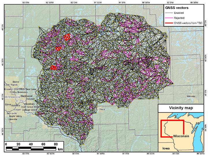
19 Introducing the NGS GIS Toolbox New Geodetic GIS tools Standard NGS ASCII output files used as input Python used to convert to point, line, polygon, and raster features Creates attribute-rich vector features in standard GIS format Used for display and analysis of results Currently consists of 5 Toolsets GPS Tools: Positions, GNSS vectors, error estimates, residuals Created to help perform 2011 national adjustment HTDP: Convert output into point features Leveling Tools: Adjusted elevations, loop misclosures, residuals Created to help adjust large statewide leveling networks NGS Grids: Convert NGS ASCII grids to Esri raster format Used to create rasters of geoid models, geoid errors, deflection of vertical Velocity Vectors: Create velocity and displacement vectors


20 NGS GIS Toolbox (ArcGIS) GPS Tools Positions, GNSS vectors, error estimates, residuals HTDP x Leveling Tools x NGS Grids x Velocity Vectors x

21 GNSS network adjustment results as GIS features provides powerful visualization and analysis capabilities

22 NAD 83(2011) epoch Horizontal accuracy, cm (95% confidence)

23 NAD 83(2011) epoch Vertical accuracy, cm (95% confidence)

24 (7 years) 12,803 vectors (3.0%)
25 (11 (7 years) 82,316 12,803 vectors (19.3%) (3.0%)
26 (15 years) 154,500 vectors (36.2%)
27 (19 years) 227,940 vectors (53.4%)

28 (23 years) 327,154 vectors (76.6%)
29 (29 years) 426,977 vectors (100.0%)

30
31

32 NGS GIS Toolbox (ArcGIS) Leveling Tools Adjusted elevations, loop misclosures, residuals HTDP x Leveling Tools x NGS Grids x Velocity Vectors x


33
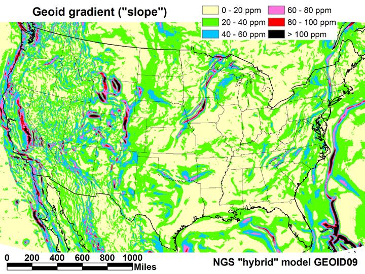
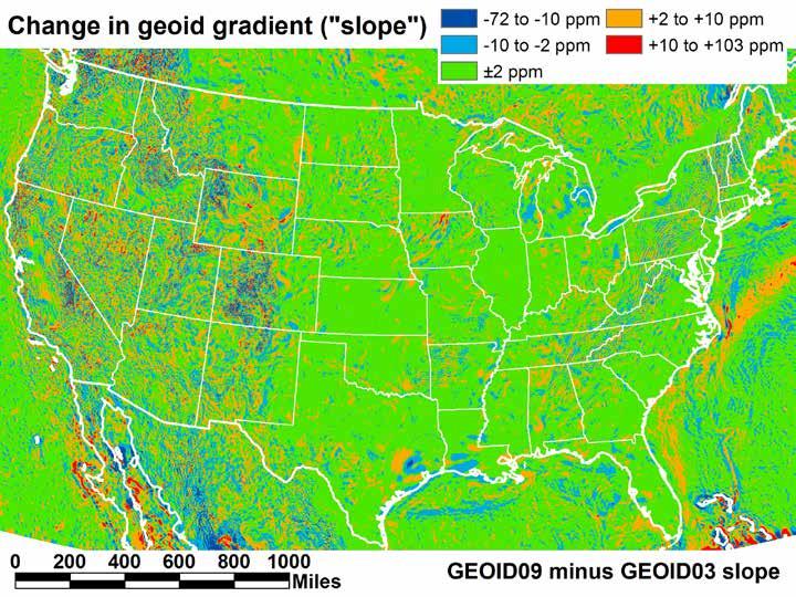
34 NGS GIS Toolbox (ArcGIS) NGS Grids Convert NGS ASCII grids to Esri raster format HTDP x Leveling Tools x NGS Grids x Velocity Vectors x
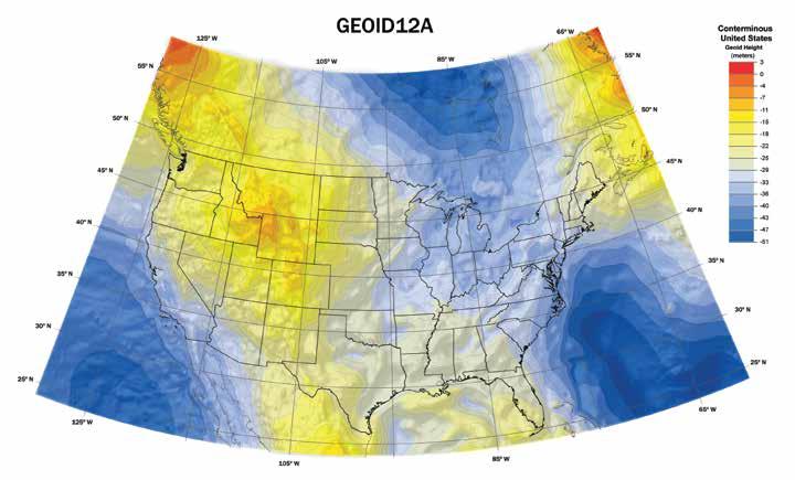
35

36

37

38
39
40

41

42

43 The Power of GIS
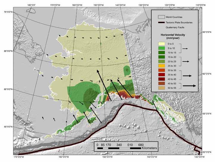
44 NGS GIS Toolbox (ArcGIS) HTDP and Velocity Vectors Convert output to point features, create velocity vectors HTDP x Leveling Tools x NGS Grids x Velocity Vectors x

45
46

47 NAD 83(2011) coordinate shifts
.")
48 Based on 7 constant transformation parameters published by NGS (7 timedependent parameters ignored), at input time = output time of (so tectonic velocities irrelevant). This is how the transformation is implemented in most commercial geospatial software.

49 Based on 14 transformation parameters published by NGS at input time = output time of (so tectonic velocities irrelevant)

50 Based on 14 transformation parameters published by NGS at input time = output time of (so tectonic velocities irrelevant)

.")
51 Based on 14 transformation parameters published by NGS at input time of output time of (5 years of tectonic movement). This much more complex case is the correct transformation.


52 Based on 7 constant transformation parameters published by NGS (7 timedependent parameters ignored), at input time = output time of (so tectonic velocities irrelevant). This is how the transformation is implemented in most commercial geospatial software.


53 Based on 14 transformation parameters published by NGS at input time of output time of The 5 years of tectonic movement has no effect since only horizontal velocities are modeled
54 NAD 83(2011) to IGS08 at epoch

55 NAD 83(PA11) to IGS08 at epoch

56 NAD 83(2011) to IGS08 at epoch
 surface minus NGS gravimetric")
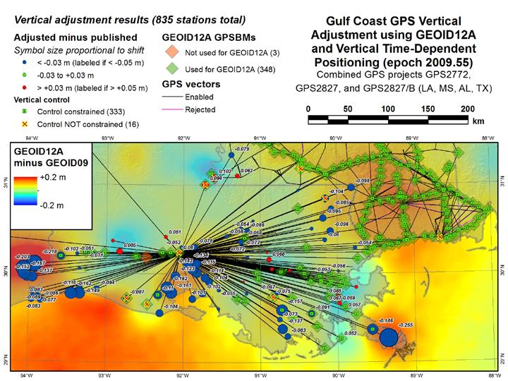
57 Orthometric height change (meters) NAVD 88 to new vertical datum Estimated as NAVD 88 "zero" (datum) surface minus NGS gravimetric geoid
58

59 More information geodesy.noaa.gov
60 Where to next NGS GIS toolbox Release soon as ArcGIS Toolbox Also plan to provide access through web interface Future enhancements Topology, survey intelligence Error ellipses, loop closures, occupations, independent observations Other NGS products and services 2011 national adjustment results in GIS format (release soon) Provide NGS products in in GIS format Creation of new spatially-enabled database Education and outreach Increase internal use of GIS by NGS employees Provide internal and external training in using the tools and data Objective: Fully leverage the power of GIS in geodesy


61 Questions?
NGS and the Modernization of the National Spatial Reference System (NSRS)
") NGS and the Modernization of the National Spatial Reference System (NSRS) Dr. Dana Caccamise Pacific Southwest Region (CA,NV) Geodetic Advisor dana.caccamise@noaa.gov NOAA s National Geodetic Survey geodesy.noaa.gov
NGS and the Modernization of the National Spatial Reference System (NSRS) Dr. Dana Caccamise Pacific Southwest Region (CA,NV) Geodetic Advisor dana.caccamise@noaa.gov NOAA s National Geodetic Survey geodesy.noaa.gov
Frames for the Future New Datum Definitions for Modernization of the U.S. National Spatial Reference System
 Figure 10. Horizontal position differences (in meters) between NAD 83 and ITRF 08 at time 2022.00 (January 1, 2022). Positional differences are shown for the North American and Pacific tectonic plates.
Positioning the Pacific: NOAA s Geospatial Activities. Juliana Blackwell, Director NOAA s National Geodetic Survey March 6, 2012
 Positioning the Pacific: NOAA s Geospatial Activities Juliana Blackwell, Director NOAA s National Geodetic Survey March 6, 2012 A Common Problem of the Early 19 th Century 1807 President Thomas Jefferson
Achieving Great Height with GNSS
 Achieving Great Height with GNSS Oregon GPS Users Group 2015 Annual Meeting January 23, 2015 Salem, Oregon Salem Convention Center Michael Dennis, RLS, PE Oregon State University National Geodetic Survey
NATRF 2022 AND LDP OCTOBER 11, 2017
 NATRF 2022 AND LDP OCTOBER 11, 2017 MODERNIZATION OF THE NSRS Why? Leaving passive control marks behind and relying solely on the CORS network for 3D positions: Older methodology relies on terrestrial
The National Spatial Reference System of the Future
 The National Spatial Reference System of the Future William Stone Southwest Region (AZ, NM, NV, UT) Geodetic Advisor william.stone@noaa.gov NOAA s National Geodetic Survey geodesy.noaa.gov Salt Lake City
MODERNIZATION OF THE NSRS
 NATRF 2022 AND LDP SEPTEMBER 12, 2017 MODERNIZATION OF THE NSRS Why? Leaving passive control marks behind and relying solely on the CORS network for 3D positions: Older methodology relies on terrestrial
The U.S. National Spatial Reference System in 2022
 Presented at the, May 29 - June 2, 2017 in The U.S. National Spatial Reference System in 2022 Daniel R. Roman, (Chief Geodesist) NOAA s National Geodetic Survey 1 Why change? Outline Naming conventions
New Datums: Replacing NAVD 88 and NAD 83
 New Datums: Replacing NAVD 88 and NAD 83 By Dave Zenk PE, LS National Geodetic Survey Northern Plains Regional Advisor 1735 Lake Drive West Chanhassen, MN 55317-8581 952-368-2548 office 612-414-9522 mobile
U.S. Datums: Where We ve Been,
 U.S. Datums: Where We ve Been, Where We re Going Modernizing the National Spatial Reference System Matt Wellslager RFA, South Carolina Geodetic Survey Presentation Outline 1. - Introductions. 2. - National
BUILDING AN ACCURATE GIS
 BUILDING AN ACCURATE GIS 2006 GIS in the Rockies Denver, Colorado September 13, 2006 William E. Linzey United States Department of Commerce National Oceanic and Atmospheric Administration National Geodetic
REFERENCING COORDINATE SYSTEMS MAP PROJECTIONS GEOREFERENCING
 GIS in Ecology SPATIAL REFERENCING COORDINATE SYSTEMS MAP PROJECTIONS GEOREFERENCING : :1 Where on earth? Early mapmakers recognized the need for a system that could locate features on the earth's surface.
LEADS. The Essential Elements of a 3-D Geographic Coordinate
 The Essential Elements of a 3-D Geographic Coordinate John W. Dix 13 September 2005 ESRI Homeland Security GIS Summit - Denver, CO John.W.Dix@nga.mil NATIONAL GEOSPATIAL-INTELLIGENCE AGENCY Overview is
Town of Chino Valley. Survey Control Network Report. mgfneerhg mc N. Willow Creek Road Prescott AZ
 Town of Chino Valley Survey Control Network Report mgfneerhg mc. 2050 N. Willow Creek Road Prescott AZ 86301 928-771-2376 Page 1 of 70 Table of Contents Town of Chino Valley Survey Datum Outline A short
GISC3325 Spring 2011 Final Exam
 GISC3325 Spring 2011 Final Exam Name: Carefully read each question. Identify the important elements and the question being asked. Show your work for partial credit. No credit for undocumented wrong answers.
Changes are coming NGS NSRS Modernization Are you Ready?
 Changes are coming NGS 2022 - NSRS Modernization Are you Ready? Pam Fromhertz Rocky Mountain Regional Advisor Pamela.Fromhertz@noaa.gov 240-988-6363 John Hunter CO State Geomatics Coordinator DRCOG March
Positioning a nation for the future: Modernizing the United States National Spatial Reference System
 Positioning a nation for the future: Modernizing the United States National Spatial Reference System Dr. Dana Caccamise USA Representative Pacific Southwest Region Geodetic Advisor dana.caccamise@noaa.gov
Spatial Data Collection using GPS: BEST PRACTICES
 Spatial Data Collection using GPS: BEST PRACTICES - 2007 Page 1 of 10 Best practices for GPS & Spatial Data Collection, Storage and Documentation These Best Practices are designed to maximize positional
Welcome to NR502 GIS Applications in Natural Resources. You can take this course for 1 or 2 credits. There is also an option for 3 credits.
 Welcome to NR502 GIS Applications in Natural Resources. You can take this course for 1 or 2 credits. There is also an option for 3 credits. The 1st credit consists of a series of readings, demonstration,
MSGIC Spring Mtg Denton April 23, 2014
 Modernization of the National Spatial Reference System Keeping Pace with Changes in Positioning Technology and User Expectations in a Dynamic World MSGIC Spring Mtg Denton April 23, 2014 Dave Doyle Base
GRAV-D. Gravity for the Re-definition of the American Vertical Datum
 GRAV-D Gravity for the Re-definition of the American Vertical Datum Why this briefing? NGS recently acquired a new airborne gravimeter Intended to support GRAV-D GRAV-D is an ambitious new plan for NGS
GPS and Mean Sea Level in ESRI ArcPad
 Summary In order to record elevation values as accurately as possible with, it is necessary to understand how ArcPad records elevation. Rather than storing elevation values relative to Mean Sea Level (MSL),
Geospatial Data Standards Considerations for the delivery of 2D and 3D spatial data February 2019
 Geospatial Data Standards Considerations for the delivery of 2D and 3D spatial data February 2019 Prepared by: GRCA Geomatics Version Date Summary of Changes Changes Made By: 1.00 March 16, 2018 Version
Coordinate Systems and Datum Transformation in ArcGIS. Brittney White and Melita Kennedy
 Coordinate Systems and Datum Transformation in ArcGIS Brittney White and Melita Kennedy Where is my data? Problem Horizontal Vertical Projections Transformations Horizontal coordinate systems Geographic
Modernization of the National Spatial Reference System 2022 Datum. Jacksonville Chapter July 2018
 Modernization of the National Spatial Reference System 2022 Datum Jacksonville Chapter July 2018 Randy Tompkins, PSM, PLS Geomatics Project Manager Surveyor, Hydrographer, & Geodesist DRMP, Inc. Jacksonville,
This week s topics. Week 6. FE 257. GIS and Forest Engineering Applications. Week 6
 FE 257. GIS and Forest Engineering Applications Week 6 Week 6 Last week Chapter 8 Combining and splitting landscape features and merging GIS databases Chapter 11 Overlay processes Questions? Next week
Making Sense of Evolving Reference Frames for North America
 Making Sense of Evolving Reference Frames for North America Mike Craymer Geodetic Survey Division, Natural Resources Canada Giovanni Sella U.S. National Geodesy Survey American Geophysical Union 2007 Joint
NGS is Scheduled to Replace NAVD 88 and NAD 83 In 2022
 NGS is Scheduled to Replace NAVD 88 and NAD 83 In 2022 Indiana Society of Professional Land Surveyors Conference January 2017 John Ellingson NGS Geodetic Advisor john.ellingson@noaa.gov 202-306-6904 1
12/26/2012. Geographic Information Systems * * * * GIS (... yrezaei
 ( - Geographic Information Systems ( ( 1 2 3 Information System Data base DB IS IS DB (Knowledge ( ( (System (Information System - (Georefrence Analysis Data + Knowledge ======== Information 4 5 ( < 10%
NR402 GIS Applications in Natural Resources
 NR402 GIS Applications in Natural Resources Lesson 1 Introduction to GIS Eva Strand, University of Idaho Map of the Pacific Northwest from http://www.or.blm.gov/gis/ Welcome to NR402 GIS Applications in
Basic Geodetics What Every GIS User Should Know
 Experts in Geomatics, Surveying, Positioning, Geospatial Data, and Mapping Sciences Basic Geodetics What Every GIS User Should Know Michael Barnes Cain & Barnes LP michael.barnes@cain-barnes.com Steven
Ground Truth Annual Conference. Optimized Design of Low Distortion Projections. Michael L. Dennis, RLS, PE
 Arizona Professional Land Surveyors Association 016 Annual Conference Ground Truth Optimized Design of Low Distortion Projections Michael L. Dennis, RLS, PE Version 3 (rev 1), May 016 Design and metadata
Introduction to Geographic Information Systems
 Introduction to Geographic Information Systems Lynn_Carlson@brown.edu 401-863-9917 The Environmental And Remote TecHnologies Lab MacMillan Hall, Room 105 http://www.brown.edu/research/earthlab/ Outline
Control Surveys and Coordinate Systems
 Control Surveys and Coordinate Systems The Earth is Round Basic Shape of the Earth: Oblate Spheroid of Revolution The length of the equatorial axis is approximately 27 miles greater than the polar axis.
New Datums: Replacing NAVD 88 and NAD 83
 New Datums: Replacing NAVD 88 and NAD 83 Professional Surveyors Association of Nebraska Winter Seminar Dave Zenk NGS Advisor February 9, 2018 Kearney, NE February 9, 2018 Professional Surveyors Association
Shape of the Earth. Data Output by the Receiver
 It is quite common for confusion to arise about the process used during a hydrographic survey when GPS-derived water surface elevation is incorporated into the data as an RTK Tide correction. This article
Inclusion of Leveling with GNSS Observations in a Single, 3-D Geodetic Survey Network Adjustment. Daniel GILLINS, U.S.A., and Michael DENNIS, U.S.A.
 Inclusion of Leveling with GNSS Observations in a Single, 3-D Geodetic Survey Network Adjustment Daniel GILLINS, U.S.A., and Michael DENNIS, U.S.A. Key words: Leveling, Integrated Geodesy, Geoid Accuracy,
Exelis and Esri Technologies for Defense and National Security. Cherie Muleh
 Exelis and Esri Technologies for Defense and National Security Cherie Muleh Cherie.Muleh@exelisinc.com ENVI IMAGERY AND DATA BECOME KNOWLEDGE > Add information from imagery to your GIS > Automated workflows
These modules are covered with a brief information and practical in ArcGIS Software and open source software also like QGIS, ILWIS.
 Online GIS Training and training modules covered are: 1. ArcGIS, Analysis, Fundamentals and Implementation 2. ArcGIS Web Data Sharing 3. ArcGIS for Desktop 4. ArcGIS for Server These modules are covered
Ground Truth Annual Conference. Design and Documentation of Low Distortion Projections for Surveying and GIS
 Professional Land Surveyors of Oregon 15 Annual Conference Ground Truth Design and Documentation of Low Distortion Projections for Surveying and GIS Michael L Dennis, RLS, PE v. (rev 1), January 15, Design
ArcGIS Data Reviewer: Assessing Positional Accuracy. Roslyn Dunn
 ArcGIS Data Reviewer: Assessing Positional Accuracy Roslyn Dunn What is ArcGIS Data Reviewer? Data Quality Management for ArcGIS Provides - Rule-based validation - Interactive tools - Track errors Validate
The U.S. National Spatial Reference System in 2022
 The U.S. National Spatial Reference System in 2022 Daniel ROMAN, U.S.A. Key words: Capacity Building; GNSS/GPS; Legislation; Positioning; Reference Frames; Reference Systems; Standards SUMMARY In 2022,
VT State Plane. Daniel J. Martin National Geodetic Survey VT Geodetic Advisor. VSLS Conference Rutland VT April 11, 2008
 VT State Plane Daniel J. Martin National Geodetic Survey VT Geodetic Advisor VSLS Conference Rutland VT April 11, 2008 Today s Outline Define the problem Review of VT State Plane System Relationship
HORIZONTAL PROJECTION PARAMETERS: DANE COUNTY COORDINATES
 Recommended RTK GPS Configuration Parameters for the City of Madison, WI Base Station Compiled by: Dan Rodman RLS, City of Madison (608)266-6674 drodman@cityofmadison.com For base station information see
Preliminary Data Release for the Humboldt Bay Sea Level Rise Vulnerability Assessment: Humboldt Bay Sea Level Rise Inundation Mapping
 Preliminary Data Release for the Humboldt Bay Sea Level Rise Vulnerability Assessment: Humboldt Bay Sea Level Rise Inundation Mapping Prepared by: Jeff Anderson, Northern Hydrology & Engineering (jeff@northernhydrology.com)
DATA 301 Introduction to Data Analytics Geographic Information Systems
 DATA 301 Introduction to Data Analytics Geographic Information Systems Dr. Ramon Lawrence University of British Columbia Okanagan ramon.lawrence@ubc.ca DATA 301: Data Analytics (2) Why learn Geographic
How GIS based Visualizations Support Land Use and Transportation Modeling
 How GIS based Visualizations Support Land Use and Transportation Modeling ESRI International Users Conference San Diego, CA - July 23, 2015 Prepared by: Troy Hightower Introduction This presentation will
GIS Boot Camp for Education June th, 2011 Day 1. Instructor: Sabah Jabbouri Phone: (253) x 4854 Office: TC 136
 x 4854 Office: TC 136") GIS Boot Camp for Education June 27-30 th, 2011 Day 1 Instructor: Sabah Jabbouri Phone: (253) 833-9111 x 4854 Office: TC 136 Email: sjabbouri@greenriver.edu http://www.instruction.greenriver.edu/gis/ Summer
GIS Boot Camp for Education June 27-30 th, 2011 Day 1 Instructor: Sabah Jabbouri Phone: (253) 833-9111 x 4854 Office: TC 136 Email: sjabbouri@greenriver.edu http://www.instruction.greenriver.edu/gis/ Summer
Understanding Projections for GIS
 Presented by John Schaeffer Juniper GIS Services, Inc. This PowerPoint is available at JuniperGIS.com Presentation Objectives To understand basic concepts on projections and coordinate systems for the
Leveraging Your Geo-spatial Data Investments with Quantum GIS: an Open Source Geographic Information System
 Leveraging Your Geo-spatial Data Investments with Quantum GIS: an Open Source Geographic Information System Donald L. Schrupp Colorado Division of Wildlife (Retired) Danny Lewis Texas Parks and Wildlife
Intro to GIS Fall 2010 Georeferencing & Map Projections
 Intro to GIS Fall 2010 Georeferencing & Map Projections SHAPE OF THE EARTH Earth's Shape Geoid: shape of earth minus topographic features (irregular due to local variations in gravity) Ellipsoid: elongated
GEOIDS FAQ. November
 GEOIDS FAQ 1. What is a geoid? A geoid is a representation of the equipotential surface of the Earth s gravity field. It can be thought of as a surface coinciding with the undisturbed mean sea level extended
Teaching GIS for Land Surveying
 Teaching GIS for Land Surveying Zhanjing (John) Yu Evergreen Valley College, San Jose, California James Crossfield California State University at Fresno, Fresno California 7/13/2006 1 Outline of the Presentation
4 Survey Datums. 4.1 Horizontal Datum Policy SURVEY DATUMS SEPTEMBER 2006
 4 Survey Datums Today s multi-organizational Project Development efforts require the use of common, accurate horizontal and vertical survey datums and consistent, precise control-survey procedures to ensure
Outline. Chapter 1. A history of products. What is ArcGIS? What is GIS? Some GIS applications Introducing the ArcGIS products How does GIS work?
 Outline Chapter 1 Introducing ArcGIS What is GIS? Some GIS applications Introducing the ArcGIS products How does GIS work? Basic data formats The ArcCatalog interface 1-1 1-2 A history of products Arc/Info
GIS and Forest Engineering Applications FE 357 Lecture: 2 hours Lab: 2 hours 3 credits
 GIS and Forest Engineering Applications FE 357 Lecture: 2 hours Lab: 2 hours 3 credits Instructor: Michael Wing Assistant Professor Forest Engineering Department Oregon State University Peavy Hall 275
Introduction to the 176A labs and ArcGIS Purpose of the labs
 Introduction to the 176A labs and ArcGIS Purpose of the labs Acknowledgement: Slides by David Maidment, U Texas-Austin and Francisco Olivera (TAMU) Hands-on experience with a leading software package Introduction
Boolean Operators and Topological OVERLAY FUNCTIONS IN GIS
 Boolean Operators and Topological OVERLAY FUNCTIONS IN GIS Query asking a question of the attribute data Standard Query Language (SQL) is used to query the data There are 4 basic statements used to get
VCCS Geospatial Institute 2011
 John McGee Jennifer McKee With support from: NSF DUE-0903270 Acquiring and Downloading Digital Data in partnership with: Geospatial Technician Education Through Virginia s Community Colleges (GTEVCC) Review
Display data in a map-like format so that geographic patterns and interrelationships are visible
 Vilmaliz Rodríguez Guzmán M.S. Student, Department of Geology University of Puerto Rico at Mayagüez Remote Sensing and Geographic Information Systems (GIS) Reference: James B. Campbell. Introduction to
Name NRS 409 Exam I. 1. (24 Points) Consider the following questions concerning standard data for GIS systems.
 Consider the following questions concerning standard data for GIS systems.") Read every question carefully. You may use a calculator if you wish. Conversion tables are provided at the end of the exam. If you have any questions, raise your hand. Be sure to show your work on computational
Read every question carefully. You may use a calculator if you wish. Conversion tables are provided at the end of the exam. If you have any questions, raise your hand. Be sure to show your work on computational
Height Modernization Program in the United States: Implementing a Vertical Datum Referenced to a Gravimetric Geoid Model
 Height Modernization Program in the United States: Implementing a Vertical Datum Referenced to a Gravimetric Geoid Renee Shields, Christine Gallagher, USA Key words: GNSS, orthometric height, elevation,
LiDAR User Data Needs Survey Results
 LiDAR User Data Needs Survey Results June 2012 Introduction The Minnesota Geospatial Information Office (MnGeo) is working with the Minnesota Department of Natural Resources (DNR) to develop a data distribution
v WMS Tutorials GIS Module Importing, displaying, and converting shapefiles Required Components Time minutes
 v. 11.0 WMS 11.0 Tutorial Importing, displaying, and converting shapefiles Objectives This tutorial demonstrates how to import GIS data, visualize it, and convert it into WMS coverage data that could be
Coordinate systems, measured surveys for BIM, total station for BIM, as-built surveys, setting-out
 Coordinate systems, measured surveys for BIM, total station for BIM, as-built surveys, setting-out What is a BIM What does a BIM do Why use a BIM BIM Software BIM and the Surveyor How do they relate to
Semi-Dynamic Datum of Indonesia
 Technical Seminar Reference Frame in Practice, Semi-Dynamic Datum of Indonesia H.Z. Abidin, A.B. Wijanarto, S.T. Wibowo, Susilo, J. Efendi Geospatial Information Agency, Indonesia (BIG) Sponsors: Page
GIS in Water Resources. Fall Homework #1
 GIS in Water Resources Fall 2015 Homework #1 Goal The goal of this homework is to reinforce the lecture material on Geodesy, Map Projections and Coordinate Systems by having you identify attributes and
International Journal of Computer Science and Telecommunications [Volume 3, Issue 7, July 2012] 109. Levelling with GPS. Dr. Nagi Zomrawi Mohammed
![International Journal of Computer Science and Telecommunications [Volume 3, Issue 7, July 2012] 109. Levelling with GPS. Dr. Nagi Zomrawi Mohammed](/thumbs/94/120062601.jpg "International Journal of Computer Science and Telecommunications [Volume 3, Issue 7, July 2012] 109. Levelling with GPS. Dr. Nagi Zomrawi Mohammed") International Journal of Computer Science and Telecommunications [Volume 3, Issue 7, July 2012] 109 ling with ISSN 2047-3338 Dr. Nagi Zomrawi Mohammed Associate Professor, College of Engineering, Sudan
International Journal of Computer Science and Telecommunications [Volume 3, Issue 7, July 2012] 109 ling with ISSN 2047-3338 Dr. Nagi Zomrawi Mohammed Associate Professor, College of Engineering, Sudan
GIS Workshop Data Collection Techniques
 GIS Workshop Data Collection Techniques NOFNEC Conference 2016 Presented by: Matawa First Nations Management Jennifer Duncan and Charlene Wagenaar, Geomatics Technicians, Four Rivers Department QA #: FRG
June 19 Huntsville, Alabama 1
 June 19 Huntsville, Alabama 1 Real-Time Geospatial Data: The Fusion of PI and ArcGIS Enabling Smarter Facilities Management OSIsoft and Esri Mapping and Location Analytics Platform Supporting Your Use
3/29/11. Why bother with tools? Incorporating Decision Support Tools into Climate Adaptation Planning. A Simplified Planning Process
 Incorporating Decision Support Tools into Climate Adaptation Planning Why bother with tools? Tools don t eliminate complexity but they can help deal with it" Tools can:"! Help incorporate science into
The Future of SPCS in Charles Chuck Ghilani, Ph.D. Professor Emeritus Pennsylvania State University
 The Future of SPCS in 2022 Charles Chuck Ghilani, Ph.D. Professor Emeritus Pennsylvania State University Class Etiquette Turn off all cell phones Or set them to vibrate Go out of the room to answer any
Lecture 12. Data Standards and Quality & New Developments in GIS
 Lecture 12 Data Standards and Quality & New Developments in GIS Lecture 12: Outline I. Data Standards and Quality 1. Types of Spatial Data Standards 2. Data Accuracy 3. III. Documenting Spatial Data Accuracy
Introduction to the 176A labs and ArcGIS
 Introduction to the 176A labs and ArcGIS Acknowledgement: Slides by David Maidment, U Texas-Austin and Francisco Olivera (TAMU) Purpose of the labs Hands-on experience with one software pakage Introduction
BECQ 2017 SLR Map Layer Updates: Methodology for Coastal Flood Geoprocessing
 BECQ 2017 SLR Map Layer Updates: Methodology for Coastal Flood Geoprocessing This paper summarizes the local and regional sea level data used to develop coastal flooding scenarios for the island of Saipan,
The 3-D Global Spatial Data Model: Geometrical Foundation of the Global Spatial Data Infrastructure
 The 3-D Global Spatial Data Model: Geometrical Foundation of the Global Spatial Data Infrastructure Earl F. Burkholder, PS, PE Annotated Table of Contents July 8,2006 I. The Global Spatial Data Model (GSDM)
GIS for Actuaries Part 1 CAS RPM Garrett Bradford March 15, 2016
 GIS for Actuaries Part 1 CAS RPM 2016 Garrett Bradford March 15, 2016 GIS for Actuaries Workshop Outline I. Introduction to GIS: the basics II. Geocoding, Uncertainty, and GIS Data Sources III. Spatial
EnvSci360 Computer and Analytical Cartography
 EnvSci360 Computer and Analytical Cartography Lecture 3 Geodesy Map Projections, Datums, and Coordinate Systems 1 Geodesy The science of measuring and representing the shape and size of the earth, and
Geographic Information Systems class # 1 February 19, Coordinate reference systems in GIS: geodetic coordinates
 Geographic Information Systems class # 1 February 19, 2013 Coordinate reference systems in GIS: geodetic coordinates Manuel Campagnolo ISA Manuel Campagnolo (ISA) GIS/SIG 2012 2013 February 19, 2013 1
ch02.pdf chap2.pdf chap02.pdf
 Introduction to Geographic Information Systems 8th Edition Karl Solutions Manual Full Download: http://testbanklive.com/download/introduction-to-geographic-information-systems-8th-edition-karl-solutions-manu
Laboratory Topic 4: Projections and Geo-Positioning in ArcGIS [ LAEP/GEOG c188 ]
![Laboratory Topic 4: Projections and Geo-Positioning in ArcGIS [ LAEP/GEOG c188 ]](/thumbs/81/82687491.jpg "Laboratory Topic 4: Projections and Geo-Positioning in ArcGIS [ LAEP/GEOG c188 ]") Laboratory Topic 4: Projections and Geo-Positioning in ArcGIS 10.4.1 - [ LAEP/GEOG c188 ] Projections in ArcGIS 10.4.1 In this tutorial you will learn to identify the Projection and Datum of a dataset,
Laboratory Topic 4: Projections and Geo-Positioning in ArcGIS 10.4.1 - [ LAEP/GEOG c188 ] Projections in ArcGIS 10.4.1 In this tutorial you will learn to identify the Projection and Datum of a dataset,
SIRGAS: Basis for Geosciences, Geodata, and Navigation in Latin America
 SIRGAS: Basis for Geosciences, Geodata, and Navigation in Latin America Claudio Brunini President of SIRGAS Universidad Nacional de La Plata, Argentina María Virginia Mackern President of SIRGAS/WG-I:
Version 1.1 GIS Syllabus
 GEOGRAPHIC INFORMATION SYSTEMS CERTIFICATION Version 1.1 GIS Syllabus Endorsed 1 Version 1 January 2007 GIS Certification Programme 1. Target The GIS certification is aimed at: Those who wish to demonstrate
ESRI Survey Summit August Clint Brown Director of ESRI Software Products
 ESRI Survey Summit August 2006 Clint Brown Director of ESRI Software Products Cadastral Fabric How does Cadastral fit with Survey? Surveyors process raw field observations Survey measurements define high-order
Session description and objectives
 Journey to the Moving Center of the Earth The Evolution of the National Spatial Reference System NJSPLS SurvCon 2018 January 31, 2018 Dan Martin Northeast Regional Geodetic Advisor ME, NH, VT, MA, CT,
SURVEYING AND MAPPING, INC. COORDINATE DATA SHEET JOB: CITY OF DECATUR CLIENT: CITY OF DECATUR SAM JOB#:
 13 March 2001 SURVEYING AND MAPPING, INC. COORDINATE DATA SHEET JOB: CITY OF DECATUR CLIENT: CITY OF DECATUR SAM JOB#: 21038-20 HORIZONTAL DATUM: NAD-83 GEODETIC VERTICAL STATION ID LATITUDE LONGITUDE
Session Objectives. Learn how to: Bring georeferenced aerial imagery into Civil 3D. Connect to and import GIS data using various tools and techniques.
 GIS into Civil 3D Data 70th Annual Wisconsin Society of Land Surveyors' Institute January 24, 2019 1 Learn how to: Session Objectives Bring georeferenced aerial imagery into Civil 3D. Connect to and import
GRAVITY SURVEY TEELS MARSH PROSPECT
 GRAVITY SURVEY over the TEELS MARSH PROSPECT MINERAL COUNTY, NV for Dajin Resources (US) Corp. March 2015 SUBMITTED BY Magee Geophysical Services LLC 465 Leventina Canyon Road Reno, Nevada 89523 USA TEL
Data Creation and Editing
 11.520:A Workshop on Geographical Information Systems 1.188: Urban Planning and Social Science Laboratory Data Creation and Editing Based in part on notes by Prof. Joseph Ferreira and Michael Flaxman Lulu
GEOID UNDULATIONS OF SUDAN USING ORTHOMETRIC HEIGHTS COMPARED WITH THE EGM96 ANG EGM2008
 GEOID UNDULATIONS OF SUDAN USING ORTHOMETRIC HEIGHTS COMPARED Dr. Abdelrahim Elgizouli Mohamed Ahmed* WITH THE EGM96 ANG EGM2008 Abstract: Positioning by satellite system determine the normal height above
Innovation. The Push and Pull at ESRI. September Kevin Daugherty Cadastral/Land Records Industry Solutions Manager
 Innovation The Push and Pull at ESRI September 2004 Kevin Daugherty Cadastral/Land Records Industry Solutions Manager The Push and The Pull The Push is the information technology that drives research and
This Land Surveying course has been developed by Failure & Damage Analysis, Inc.
 This Land Surveying course has been developed by Failure & Damage Analysis, Inc. www.discountpdh.com DEPARTMENT OF THE ARMY U.S. Army Corps of Engineers CECW-EP Washington, DC 20314-1000 ETL 1110-1-183
Geographical Information System GIS
 Geographical Information System GIS LOOM.02.331 anto.aasa@ut.ee Scale GIS and spatial planning National Regional Local Strategic (National Dev. Plan) National Goals and development policy Tactical (Regional
COURSE SCHEDULE, GRADING, and READINGS
 COURSE SCHEDULE, GRADING, and READINGS Note: All academic classes will be held in the GIS lab at Royal Thimphu College. These dates are listed here. Other days will involve travel or days off, and the
Key Questions and Issues. What is GIS? GIS is to geographic analysis as: What is GIS? 9/3/2013. GEO 327G/386G, UT Austin 1
 What is GIS? Key Questions and Issues Geology Elevation Transportation Hydrography Imagery What is GIS? What are the applications of GIS? How is the real world represented in GIS? What analyses can GIS
ABSTRACT The first chapter Chapter two Chapter three Chapter four
 ABSTRACT The researches regarding this doctoral dissertation have been focused on the use of modern techniques and technologies of topography for the inventory and record keeping of land reclamation. The
Spatial Analysis with Web GIS. Rachel Weeden
 Spatial Analysis with Web GIS Rachel Weeden Agenda Subhead goes here Introducing ArcGIS Online Spatial Analysis Workflows Scenarios Other Options Resources ArcGIS is a Platform Making mapping and analytics
GIS CONCEPTS ARCGIS METHODS AND. 3 rd Edition, July David M. Theobald, Ph.D. Warner College of Natural Resources Colorado State University
 GIS CONCEPTS AND ARCGIS METHODS 3 rd Edition, July 2007 David M. Theobald, Ph.D. Warner College of Natural Resources Colorado State University Copyright Copyright 2007 by David M. Theobald. All rights
Using a GIS to Calculate Area of Occupancy. Part 1: Creating a Shapefile Grid
 Using a GIS to Calculate Area of Occupancy Part 1: Creating a Shapefile Grid By Ryan Elliott California Natural Diversity Database, A NatureServe network program December 2008 This document describes the
10/13/2011. Introduction. Introduction to GPS and GIS Workshop. Schedule. What We Will Cover
 Introduction Introduction to GPS and GIS Workshop Institute for Social and Environmental Research Nepal October 13 October 15, 2011 Alex Zvoleff azvoleff@mail.sdsu.edu http://rohan.sdsu.edu/~zvoleff Instructor: