Preliminary Results from Coordinated Sea-Level Rise Modeling Using SLAMM, the Sea Level Affecting Marshes Model, Across the US Gulf of Mexico Coast
|
|
|
- Chastity Stone
- 5 years ago
- Views:
Transcription
1 Preliminary Results from Coordinated Sea-Level Rise Modeling Using SLAMM, the Sea Level Affecting Marshes Model, Across the US Gulf of Mexico Coast James W. Pahl, Ph.D., and Kristin DeMarco, State of Louisiana Jonathan Clough, Warren Pinnacle Consulting Kathleen Freeman and Laura Geselbracht, The Nature Conservancy Florida Chapter Alicia Bihler, Heidi Beck and Melissa Kemm, Duke University Presentation at the 6 th National Conference on Coastal and Estuarine Habitat Restoration (2012 Restore America s Estuaries Conference) Tampa, Florida Wednesday, 24 October 2012
2 Sea-Level Rise as a Priority Topic for the Gulf of Mexico Alliance Initial Gulf of Mexico Alliance efforts included Direct Alliance funding of some sea-level rise modeling efforts,
3 Sea-Level Rise as a Priority Topic for the Gulf of Mexico Alliance Initial Gulf of Mexico Alliance efforts included Direct Alliance funding of some sea-level rise modeling efforts, Indirect support of efforts supporting Alliance priorities, and E.g. US EPA Gulf of Mexico Program has funded projects pursuant to goals of the Gulf of Mexico Alliance, including the Habitat Conservation and Restoration Priority Issue Team
4 Sea-Level Rise as a Priority Topic for the Gulf of Mexico Alliance Initial Gulf of Mexico Alliance efforts included Direct Alliance funding of some sea-level rise modeling efforts, Indirect support of efforts supporting Alliance priorities, and E.g. US EPA Gulf of Mexico Program has funded projects pursuant to goals of the Gulf of Mexico Alliance, including the Habitat Conservation and Restoration Priority Issue Team Coordination with external efforts.
5 Sea-Level Rise as a Priority Topic for the Gulf of Mexico Alliance Initial Gulf of Mexico Alliance efforts included Direct Alliance funding of some sea-level rise modeling efforts, Indirect support of efforts supporting Alliance priorities, and Coordination of external efforts. Recently, delivery of modeling data from disparate sources has created a large set of data to be more robustly mined for trends.
6 Criteria for Comparative Analysis Same technology - SLAMM versions 5 and 6 Same scenarios of future global sea-level rise by 2100 Most runs have looked at 0.39 meters (IPCC A1B-mean) 0.69 meters (IPCC A1B-max) 1 meter 1.5 meters Team has begun discussions of robust statistical analysis of entire collection of analyses across scenarios Presentation will focus only on modeling results assuming 1-meter global sea-level rise by 2100
7 Recent Sea-Level Rise Guidance
8 Recent Sea-Level Rise Guidance
9 Recent Sea-Level Rise Guidance

10 Recent Sea-Level Rise Guidance development/boards/climatechange-task-force.asp
11 Summary of Contributing Efforts US Fish & Wildlife Service, National Wildlife Refuge System Funding from US Fish & Wildlife Service Sites Aransas National Wildlife Refuge, TX Bayou Sauvage National Wildlife Refuge, LA Big Branch National Wildlife Refuge, LA Bon Secour National Wildlife Refuge, AL Delta National Wildlife Refuge, LA Sabine National Wildlife Refuge, LA Shell Keys National Wildlife Refuge, LA St. Marks National Wildlife Refuge, FL
12 Summary of Contributing Efforts Gulf of Mexico Alliance, Habitat Conservation & Restoration Team and Coastal Community Resilience Team Funding from NOAA Cooperative Agreements Sites Galveston Bay, TX Grand Bay NERR and Environs, MS Saint Andrew & Choctawhatchee Bays, FL South Jefferson County, TX
13 Summary of Contributing Efforts Gulf of Mexico Alliance, Habitat Conservation & Restoration Team Funding from NOAA Cooperative Agreement in support of US Fish & Wildlife Service Sites Great White Heron National Wildlife Refuge, FL Lower Suwannee River National Wildlife Refuge, FL Mississippi Sandhill Crane National Wildlife Refuge, MS San Bernard and Big Boggy National Wildlife Refuges, TX Ten Thousand Islands National Wildlife Refuge, FL
14 Summary of Contributing Efforts The Nature Conservancy Florida Chapter Funding from EPA Gulf of Mexico Program and other funds Sites Apalachicola Bay, FL Charlotte Harbor, FL Corpus Christi Bay, TX Mobile Bay, AL Pensacola Bay, FL Southern Big Bend, FL Tampa Bay, FL
15 Summary of Contributing Efforts Duke University, Nicholas School of the Environment and Earth Sciences Funding by the Nicholas School Sites Lafourche Parish, LA St. Mary Parish, LA Vermilion Parish, LA

16 Spatial Coverage of Component Analyses Land/wetland area modeled 14,800,123 acres modeled across five Gulf states Alabama: 90,968 acres Florida: 6,941,504 acres Louisiana: 2,883,883 acres Mississippi: 23,496 acres Texas: 4,331,723 acres NOTE: By-state totals do not include 78,759-acre Grand Bay NERR & Environs Area modeled by Warren Pinnacle (split between AL & MS)

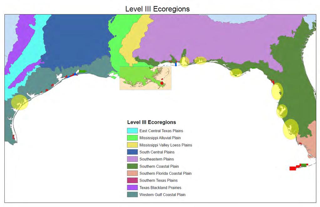
17 Spatial Coverage of Component Analyses Area of analysis covers coastal areas of four Department of Interior Land Conservation Cooperatives Gulf Coastal Plains and Ozarks Gulf Coast Prairie Peninsular Florida South Atlantic
18
19 Initial Results
20 Change in Habitat Acreage 1 meter SLR by 2100
21 Change in Habitat Acreage 1 meter SLR by 2100
22 Change in Habitat Acreage 1 meter SLR by 2100
23 Global Sea-Level Rise Curves GULF SEA LEVEL (meters above 1992) m Scenario 1.0-m Scenario 0.5-m Scenario Historic Linear (2.4 mm/yr) YEAR
24 Change in Habitat Acreage 1 meter SLR by 2100
25 Lower Suwannee National Wildlife Refuge, FL INITIAL CONDITION
26 Lower Suwannee National Wildlife Refuge, FL INITIAL CONDITION 2025

27 Lower Suwannee National Wildlife Refuge, FL INITIAL CONDITION 2050
28 Lower Suwannee National Wildlife Refuge, FL INITIAL CONDITION 2075
29 Lower Suwannee National Wildlife Refuge, FL INITIAL CONDITION 2100
30 Change in Habitat Acreage 1 meter SLR by 2100
31 Grand Bay National Estuarine Research Reserve and Environs, AL & MS

32 Grand Bay National Estuarine Research Reserve and Environs, AL & MS
33 Grand Bay National Estuarine Research Reserve and Environs, AL & MS
34 Grand Bay National Estuarine Research Reserve and Environs, AL & MS
35 Grand Bay National Estuarine Research Reserve and Environs, AL & MS
 of southeastern Louisiana s Mississippi River delta using Rahmstorf and Vermeer (2009) scenarios of 0.6- and 1.9-m SLR by 2100")
36 Next Steps Re-analyze non-comparable SLAMM model applications to allow for subsequent inclusion into this analysis E.g. National Wildlife Federation effort modeled approx. 39,000 square kilometers (9,637,000 acres) of southeastern Louisiana s Mississippi River delta using Rahmstorf and Vermeer (2009) scenarios of 0.6- and 1.9-m SLR by 2100
37 Additional SLAMM Analyses Other SLAMM Model Runs for the US Gulf Coast Gulf Coast of Florida (University of Florida, sponsored by US Department of Defense Strategic Environmental Research & Development Program) Southeastern Louisiana (Warren Pinnacle Consulting, sponsored by National Wildlife Federation)
38 Next Steps Re-analyze non-comparable SLAMM model applications to allow for subsequent inclusion into this analysis Coordinate data access with comparable modeling efforts in Mexico
39 Next Steps Re-analyze non-comparable SLAMM model applications to allow for subsequent inclusion into this analysis Coordinate data access with comparable modeling efforts in Mexico Bring all available data into conservation planning tools (Brenner presentation)
40 Next Steps Re-analyze non-comparable SLAMM model applications to allow for subsequent inclusion into this analysis Coordinate data access with comparable modeling efforts in Mexico Bring all available data into conservation planning tools (Brenner presentation) Perform formal statistical analysis across domains, across all scenarios and time steps
41 Next Steps Re-analyze non-comparable SLAMM model applications to allow for subsequent inclusion into this analysis Coordinate data access with comparable modeling efforts in Mexico Bring all available data into conservation planning tools (Brenner presentation) Perform formal statistical analysis across domains, across all scenarios and time steps Compare SLAMM model run outputs to other technologies applied to same domains

42 Non-SLAMM Sea-Level Rise Analyses Modeling analysis for 2012 revision to State of Louisiana s Comprehensive Master Plan NOAA Center for Sponsored Coastal Ocean Research, Ecological Effects of Sea Level Rise in the Northern Gulf of Mexico project
43 Next Steps Re-analyze non-comparable SLAMM model applications to allow for subsequent inclusion into this analysis Coordinate data access with comparable modeling efforts in Mexico Bring all available data into conservation planning tools (Brenner presentation) Perform formal statistical analysis across domains, across all scenarios and time steps Compare SLAMM model run outputs to other technologies applied to same domains Explore technical improvements to existing and next generation of models (Ramseur and DeMarco presentation)
44 Next Steps Re-analyze non-comparable SLAMM model applications to allow for subsequent inclusion into this analysis Coordinate data access with comparable modeling efforts in Mexico Bring all available data into conservation planning tools (Brenner presentation) Perform formal statistical analysis across domains, across all scenarios and time steps Compare SLAMM model run outputs to other technologies applied to same domains Explore technical improvements to existing and next generation of models (Ramseur and DeMarco presentation) Incorporate data into Gulf-wide management strategies (Dausman presentation)
45 Next Steps Re-analyze non-comparable SLAMM model applications to allow for subsequent inclusion into this analysis Coordinate data access with comparable modeling efforts in Mexico Bring all available data into conservation planning tools Perform formal statistical analysis across domains, across all scenarios and time steps Compare SLAMM model run outputs to other technologies applied to same domains Explore technical improvements to existing and next generation of models Incorporate data into Gulf-wide management strategies Suggestions for Other Next Steps?

46 Thanks for your time! Reports can be found at James Pahl, Louisiana Coastal Protection & Restoration Authority Questions?
Evaluation of Regional SLAMM Results to Establish a Consistent Framework of Data and Models
 Evaluation of Regional SLAMM Results to Establish a Consistent Framework of Data and Models Prepared for the Gulf Coast Prairie Landscape Conservation Cooperative June, 2015 Minor Revisions, March 2016
THE GULF COAST VULNERABILITY ASSESSMENT:
 THE GULF COAST VULNERABILITY ASSESSMENT: Informing Adaptation Options in Landscape Conservation Design Cynthia Edwards GCPO and GCP LCC Wildlife Management Institute Peninsular Florida LCC Steering Committee
Earth Wind & Fire. Game Changing Restoration Options in the Texas Chenier Plain
 Earth Wind & Fire Game Changing Restoration Options in the Texas Chenier Plain EARTH: The Chenier Plain is a 5 million acre coastal region in Southwest Louisiana and Southeast Texas providing landscape
Evaluation of Regional SLAMM Results to Establish a Consistent Framework of Data and Models
 Evaluation of Regional SLAMM Results to Establish a Consistent Framework of Data and Models Gulf Coast Prairie Land Conservation Cooperative December 15, 2014 PO Box 315, Waitsfield VT, 05673 (802)-496-3476
SEA LEVEL RISE IN THE 2017 COASTAL MASTER PLAN
 SEA LEVEL RISE IN THE 2017 COASTAL MASTER PLAN James W. Pahl, Ph.D. Coastal Resources Scientist, Senior Presentation to the Barataria-Terrebonne National Estuary Program Management Conference Meeting Nicholls
Application of the Sea-Level Affecting Marshes Model (SLAMM 6) to Texas Point NWR
 to Texas Point NWR") Application of the Sea-Level Affecting Marshes Model (SLAMM 6) to Texas Point NWR U. S. Fish and Wildlife Service National Wildlife Refuge System Division of Natural Resources and Conservation Planning
Application of the Sea-Level Affecting Marshes Model (SLAMM 6) to Texas Point NWR U. S. Fish and Wildlife Service National Wildlife Refuge System Division of Natural Resources and Conservation Planning
Introduction: The Gulf of Mexico Alliance. The Gulf GAME project MERMAid and PHINS Results & Conclusions What s next? Examples
 AAG Las Vegas March 25, 2009 Introduction: Ocean governance and Ecosystem-Based Management The Gulf of Mexico Alliance Habitat Identification and Characterization The Gulf GAME project MERMAid and PHINS
Should (R)SET-MH data be used to forecast the effects of sea level rise on wetland resilience and carbon sequestration?
SET-MH data be used to forecast the effects of sea level rise on wetland resilience and carbon sequestration?") Should (R)SET-MH data be used to forecast the effects of sea level rise on wetland resilience and carbon sequestration? Randall W. Parkinson, Ph.D., P.G. Institute for Water and Environment Florida International
Should (R)SET-MH data be used to forecast the effects of sea level rise on wetland resilience and carbon sequestration? Randall W. Parkinson, Ph.D., P.G. Institute for Water and Environment Florida International
Application of the Sea-Level Affecting Marshes Model (SLAMM 6) to MS Sandhill Crane NWR
 to MS Sandhill Crane NWR") Application of the Sea-Level Affecting Marshes Model (SLAMM 6) to MS Sandhill Crane NWR Prepared for Gulf of Mexico Alliance Habitat Conservation and Restoration Priority Issue Team Corpus Christi, TX
Application of the Sea-Level Affecting Marshes Model (SLAMM 6) to MS Sandhill Crane NWR Prepared for Gulf of Mexico Alliance Habitat Conservation and Restoration Priority Issue Team Corpus Christi, TX
Smooth Cordgrass Varieties. Description and Performance
 Smooth Cordgrass Varieties Description and Performance Smooth cordgrass (Spartina alterniflora Loisel.) is a perennial grass native to intertidal saline marshes along the Gulf of Mexico and Atlantic coasts.
Status of Big Bend oyster populations The view from deep history
 Status of Big Bend oyster populations The view from deep history Greg Herbert School of Geosciences Stephen Hesterberg Integrative Biology Thomas Pluckhahn Department of Anthropology http://myfwc.com/media/4242314/chimmp2017-chapter01-introduction.pdf
USGS efforts to model sea-level rise impact to tidal marshes along the California coast.
 USGS efforts to model sea-level rise impact to tidal marshes along the California coast. Karen Thorne 1 J.Y Takekawa 1, K. Buffington 1, K. Swanson 2, J. Drexler 2, D.Schoellhamer 2, M. Casazza 3, and
Modeling Sea-Level Rise in Coastal Wetlands: Understanding Potential Impacts and Their Implications for Management on Cape Cod
 Modeling Sea-Level Rise in Coastal Wetlands: Understanding Potential Impacts and Their Implications for Management on Cape Cod C a p e C o a s t a l C o n f e r e n c e H y a n n i s R e s o r t a n d
Application of the Sea-Level Affecting Marshes Model (SLAMM 6) to Ten Thousand Islands NWR
 to Ten Thousand Islands NWR") Application of the Sea-Level Affecting Marshes Model (SLAMM 6) to Ten Thousand Islands NWR Prepared for Gulf of Mexico Alliance Habitat Conservation and Restoration Priority Issue Team Corpus Christi,
Application of the Sea-Level Affecting Marshes Model (SLAMM 6) to Ten Thousand Islands NWR Prepared for Gulf of Mexico Alliance Habitat Conservation and Restoration Priority Issue Team Corpus Christi,
A Regional Database Tracking Fire Footprint Each Year within the South Atlantic Region: Current Database Description and Future Directions
 A Regional Database Tracking Fire Footprint Each Year within the South Atlantic Region: Current Database Description and Future Directions Last Updated on September 30, 2018 Contributors: NatureServe,
The Use of Geographic Information Systems to Assess Change in Salt Marsh Ecosystems Under Rising Sea Level Scenarios.
 The Use of Geographic Information Systems to Assess Change in Salt Marsh Ecosystems Under Rising Sea Level Scenarios Robert Hancock The ecological challenges presented by global climate change are vast,
Developed in Consultation with Florida Educators
 Developed in Consultation with Florida Educators Table of Contents Next Generation Sunshine State Standards Correlation Chart... 7 Benchmarks Chapter 1 The Practice of Science...................... 11
Descriptions and Performance
 LSU AgCenter Coastal Plants Program Smooth Cordgrass Varieties: Descriptions and Performance Smooth cordgrass (Spartina alterniflora Loisel.) is a perennial grass native to intertidal saline marshes along
Application of the Sea-Level Affecting Marshes Model (SLAMM 5.0) to Bon Secour National Wildlife Refuge
 to Bon Secour National Wildlife Refuge") Application of the Sea-Level Affecting Marshes Model (SLAMM 5.0) to Bon Secour National Wildlife Refuge Prepared For: Dr. Brian Czech, Conservation Biologist U. S. Fish and Wildlife Service National Wildlife
Application of the Sea-Level Affecting Marshes Model (SLAMM 5.0) to Bon Secour National Wildlife Refuge Prepared For: Dr. Brian Czech, Conservation Biologist U. S. Fish and Wildlife Service National Wildlife
Name: Date: Class: Louisiana: Our History, Our Home Chapter 1: Louisiana s Geography - Section 2: Natural Regions Guided Reading
 Instructions: Read the section and complete each item with words from the passages in this section. 1. The diversity of Louisiana s can surprise residents and visitors alike. 2. Physical geography is concerned
EROSIONAL RATES IN THE POINT AUX CHENES BAY AREA, MISSISSIPPI: Kathleen P. Wacker G. Alan Criss INTRODUCTION
 Summary of a Paper Presented at the: Sixtieth Annual Meeting of the Mississippi Academy of Sciences in Jackson, Mississippi February 22, 1996 ===============================================================
Planning for Sea Level Rise in the Matanzas Basin
 Planning for Sea Level Rise in the Matanzas Basin Appendix C: Application of the Sea Level Affecting Marshes Model (SLAMM) in the Matanzas Basin June, 2015 Prepared by: Dr. Anna Cathey Linhoss and Dr.
Oyster Reef for Shoreline Stabilization and Restoration. Jason Kirkpatrick Conservation Program Manager MacDill AFB Tampa, Florida
 Oyster Reef for Shoreline Stabilization and Restoration Jason Kirkpatrick Conservation Program Manager MacDill AFB Tampa, Florida Interbay Penninsula Port of Tampa X The few remaining mangroves are being
Coastal Litigation in the Context of Science Literacy
 Coastal Litigation in the Context of Science Literacy Chris McLindon New Orleans Geological Society February 6, 7 Science Literacy The value of community participation in scientific research is widely
Application of the Sea-Level Affecting Marshes Model (SLAMM 5.0) to Green Cay National Wildlife Refuge
 to Green Cay National Wildlife Refuge") Application of the Sea-Level Affecting Marshes Model (SLAMM 5.0) to Green Cay National Wildlife Refuge Prepared For: Dr. Brian Czech, Conservation Biologist U. S. Fish and Wildlife Service National Wildlife
Application of the Sea-Level Affecting Marshes Model (SLAMM 5.0) to Green Cay National Wildlife Refuge Prepared For: Dr. Brian Czech, Conservation Biologist U. S. Fish and Wildlife Service National Wildlife
Hurricane Katrina and Oil Spills: Impact on Coastal and Ocean Environments
 Archived version from NCDOCKS Institutional Repository http://libres.uncg.edu/ir/asu/ Pine, J. C. (June 2006). Hurricane Katrina and oil spills: Impact on coastal and ocean environments. Oceanography,
U.S. Department of the Interior U.S. Geological Survey. Krista Karstensen Mark Drummond
 USGS Land-Cover Trends: A focus on contemporary land-use and land-cover change within the LCCs U.S. Department of the Interior U.S. Geological Survey Krista Karstensen Mark Drummond The Challenge Land
Application of the Sea-Level Affecting Marshes Model (SLAMM 6) to Pelican Island NWR
 to Pelican Island NWR") Application of the Sea-Level Affecting Marshes Model (SLAMM 6) to Pelican Island NWR U. S. Fish and Wildlife Service National Wildlife Refuge System Division of Natural Resources and Conservation Planning
Application of the Sea-Level Affecting Marshes Model (SLAMM 6) to Pelican Island NWR U. S. Fish and Wildlife Service National Wildlife Refuge System Division of Natural Resources and Conservation Planning
Marine Spatial Planning: A Tool for Implementing Ecosystem-Based Management
 Marine Spatial Planning: A Tool for Implementing Ecosystem-Based Management Steven Murawski, Ph.D., Ecosystem Goal Team Lead National Oceanic and Atmospheric Administration NOAA November 16, 2009 1 To
Regional Sediment Management
 Regional Sediment Management Linda S. Lillycrop Program Manager Coastal Engineer US Army Engineer Research and Development Center Coastal and Hydraulics Laboratory Q AVG Coastal Resilience: The Environmental,
Mangrove Restoration and Migration in a Changing Climate: Climatic Drivers and Shifting Ecotones
 Mangrove Restoration and Migration in a Changing Climate: Climatic Drivers and Shifting Ecotones Michael J. Osland & Richard H. Day U.S. Geological Survey, National Wetlands Research Center U.S. Department
Weather Research Center
 Weather Research Center 3227 Audley Houston, Texas 77098 Phone: 713-529-3076 Fax: 713-528-3538 E-mail: wrc@wxresearch.org Press Release For Immediate Release November 29, 2005 For Information Contact:
Sea Level Rise Providing Nature A-Right-of Way
 Sea Level Rise Providing Nature A-Right-of Way Study Area Site 2: Skagit Bay Initial Condition 11.2 Inches by 2050 No Dikes 27.3 Inches by 2100 No Dikes The Problem Loss of coastal wetlands due to submergence
Conrad Blucher Institute for Surveying and Science
 d James Rizzo Assistant irector of Operations - Office: 361-825-5758 Mobile: 361-549-5120 james.rizzo@tamucc.edu d d Texas Coastal Ocean Observation N Network (TCOON) Began in 1988 with 2 stations in Bay
The United States & Canada. A Regional Study of Anglo America
 A Regional Study of Anglo America Landform Regions of the United States & Canada world leaders in agricultural and industrial production because of... VAST LANDS stretch from the Atlantic Ocean on the
CHAPTER 1. Geo Challenges 1A to 1D. & World Map Activity
 CHAPTER 1 Geo Challenges 1A to 1D & World Map Activity SELECT YOUR CHALLENGE World Map Activity Challenge 1A Challenge 1B Challenge 1C Challenge 1D Challenge 1A WS PG. 2 STEP #1 Label the largest continent
Application of the Sea-Level Affecting Marshes Model (SLAMM 6) to Back Bay NWR
 to Back Bay NWR") Application of the Sea-Level Affecting Marshes Model (SLAMM 6) to Back Bay NWR U. S. Fish and Wildlife Service National Wildlife Refuge System Division of Natural Resources and Conservation Planning Conservation
Application of the Sea-Level Affecting Marshes Model (SLAMM 6) to Back Bay NWR U. S. Fish and Wildlife Service National Wildlife Refuge System Division of Natural Resources and Conservation Planning Conservation
Application of the Sea-Level Affecting Marshes Model (SLAMM 6) to John Heinz NWR
 to John Heinz NWR") Application of the Sea-Level Affecting Marshes Model (SLAMM 6) to John Heinz NWR Prepared for: U. S. Fish and Wildlife Service National Wildlife Refuge System Division of Natural Resources and Conservation
Application of the Sea-Level Affecting Marshes Model (SLAMM 6) to John Heinz NWR Prepared for: U. S. Fish and Wildlife Service National Wildlife Refuge System Division of Natural Resources and Conservation
NOAA s OCM: Services, tools and collaboration opportunities & Puerto Rico s NE Marine Corridor as a case study
 NOAA s OCM: Services, tools and collaboration opportunities & Puerto Rico s NE Marine Corridor as a case study Dr. Antares Ramos Álvarez NOAA s Office of Coastal Management September 15 th, 2016 Conservation
Harmful Algal Bloom Detectives in the Gulf of Mexico Satellites, Gliders and Buoys, Oh My!
 Harmful Algal Bloom Detectives in the Gulf of Mexico Satellites, Gliders and Buoys, Oh My! By Chris Simoniello and Ruth Mullins* With information from: *The Gulf of Mexico Coastal Ocean Observing System
ΛTKINS. Applications of Regional Sediment Management Concepts in Texas Estuarine Restoration Projects. Riparian Workshop Fort Worth, October 17, 2012
 Juan C Moya, PhD., PG Coastal Planning and Restoration Applications of Regional Sediment Management Concepts in Texas Estuarine Restoration Projects Riparian Workshop Fort Worth, October 17, 2012 West
Application of the Sea-Level Affecting Marshes Model (SLAMM 6) to Potomac River NWR Complex
 to Potomac River NWR Complex") Application of the Sea-Level Affecting Marshes Model (SLAMM 6) to Potomac River NWR Complex U. S. Fish and Wildlife Service National Wildlife Refuge System Division of Natural Resources and Conservation
Application of the Sea-Level Affecting Marshes Model (SLAMM 6) to Potomac River NWR Complex U. S. Fish and Wildlife Service National Wildlife Refuge System Division of Natural Resources and Conservation
Application of the Sea-Level Affecting Marshes Model (SLAMM 5.0) to Cabo Rojo and Laguna Cartagena National Wildlife Refuge
 to Cabo Rojo and Laguna Cartagena National Wildlife Refuge") Application of the Sea-Level Affecting Marshes Model (SLAMM 5.0) to Cabo Rojo and Laguna Cartagena National Wildlife Refuge Prepared For: Dr. Brian Czech, Conservation Biologist U. S. Fish and Wildlife
Application of the Sea-Level Affecting Marshes Model (SLAMM 5.0) to Cabo Rojo and Laguna Cartagena National Wildlife Refuge Prepared For: Dr. Brian Czech, Conservation Biologist U. S. Fish and Wildlife
The South Atlantic LCC s Third Thursday Web Forum
 The South Atlantic LCC s Third Thursday Web Forum Establishing explicit biological objectives to guide Strategic Habitat Conservation for the Gulf coast 2-16-2017 Agenda Introduction Monthly topic Questions
Application #: TEXT
 TOWN OF FORT MYERS BEACH 2008 PROPOSED COMPREHENSIVE PLAN AMENDMENTS Application #: 2008-13-TEXT Description: Modify the Coastal Management and Future Land Use Elements to reflect the state s new definition
Overview. Gulf of Mexico Alliance Ocean and Coastal Mapping Regional Ecosystem Data Management (REDM) Q2O (QARTOD to OGC) Things to Consider
 Q2O (QARTOD to OGC) Things to Consider") 1 Overview Gulf of Mexico Alliance Ocean and Coastal Mapping Regional Ecosystem Data Management (REDM) Q2O (QARTOD to OGC) Things to Consider 2 Gulf Of Mexico Alliance Partnership of the states of Alabama,
1 Overview Gulf of Mexico Alliance Ocean and Coastal Mapping Regional Ecosystem Data Management (REDM) Q2O (QARTOD to OGC) Things to Consider 2 Gulf Of Mexico Alliance Partnership of the states of Alabama,
Changes in Texas Ecoregions
 Comment On Lesson Changes in Texas Ecoregions The state of Texas can be divided into 10 distinct areas based on unique combinations of vegetation, topography, landforms, wildlife, soil, rock, climate,
West Galveston Bay Regional Sediment Management Plan (An Eco-geomorphologic Approach)
") West Galveston Bay Regional Sediment Management Plan (An Eco-geomorphologic Approach) Juan Moya, Matthew Mahoney and Mike Smith Restore America s Estuaries Conference Tampa, FL, October 23, 2012 Atkins
West Galveston Bay Regional Sediment Management Plan (An Eco-geomorphologic Approach) Juan Moya, Matthew Mahoney and Mike Smith Restore America s Estuaries Conference Tampa, FL, October 23, 2012 Atkins
4th Grade U.S. Regional Geography
 4th Grade U.S. Regional Geography Multiple Choice Identify the choice that best completes the statement or answers the question. What does the term mainland mean in the sentence above? A the continent
Storm Surge Analysis Update Meeting Cross City, Florida June 17, 2014
 Big Bend Coastal Storm Surge Study Storm Surge Analysis Update Meeting Cross City, Florida June 17, 2014 Introductions Risk MAP Project Team FEMA Region IV Florida Division of Emergency Management (FDEM)
Sea-level Rise on Cape Cod: How Vulnerable Are We? Rob Thieler U.S. Geological Survey Woods Hole, MA
 Sea-level Rise on Cape Cod: How Vulnerable Are We? Rob Thieler U.S. Geological Survey Woods Hole, MA Outline Sea-level and coastal processes Past sea-level change Predictions for the future Coastal responses
Integrating new coastline information and geographically coordinated coastal geomorphology data
 Integrating new coastline information and geographically coordinated coastal geomorphology data NOAA Contemporary Shoreline DOE Coastal Geomorphology Cynthia Miller Corbett Jeff Simley 1 National Hydrography
The Worst Places for Hurricanes
 The Worst Places for Hurricanes Hurricane Hotspots By now, everyone knows that the last two hurricane seasons have been particularly severe. Severe yes, but compared to what? Hurricane experts are saying
National Wetlands Inventory Update for New England 2009
 National Wetlands Inventory Update for New England 2009 Ralph Tiner Wetland Ecologist U.S. Fish & Wildlife Service National Wetlands Inventory Program Where we ve been Maps Status and trends investigations
Quantifying effects of oil on coastal dune vegetation. Thomas Miller and Elise Gornish Biological Science, Florida State University
 Quantifying effects of oil on coastal dune vegetation Thomas Miller and Elise Gornish Biological Science, Florida State University Natural History of Barrier Islands in the Northern Gulf Make up ~70% of
PRESS RELEASE LOUISIANA UNIVERSITIES MARINE CONSORTIUM July 31, 2011
 PRESS RELEASE LOUISIANA UNIVERSITIES MARINE CONSORTIUM July 31, 2011 Scientists have returned from mapping the 2011 area of hypoxia, commonly known as the Dead Zone, along the Louisiana coast. This year
Application of the Sea-Level Affecting Marshes Model (SLAMM 5.0) to Salinas River NWR
 to Salinas River NWR") Application of the Sea-Level Affecting Marshes Model (SLAMM 5.0) to Salinas River NWR Prepared For: Dr. Brian Czech, Conservation Biologist U. S. Fish and Wildlife Service National Wildlife Refuge System
Application of the Sea-Level Affecting Marshes Model (SLAMM 5.0) to Salinas River NWR Prepared For: Dr. Brian Czech, Conservation Biologist U. S. Fish and Wildlife Service National Wildlife Refuge System
Application of the Sea-Level Affecting Marshes Model (SLAMM 6) to Guam NWR
 to Guam NWR") Application of the Sea-Level Affecting Marshes Model (SLAMM 6) to Guam NWR Prepared For U. S. Fish and Wildlife Service National Wildlife Refuge System Division of Natural Resources and Conservation Planning
Application of the Sea-Level Affecting Marshes Model (SLAMM 6) to Guam NWR Prepared For U. S. Fish and Wildlife Service National Wildlife Refuge System Division of Natural Resources and Conservation Planning
Application of the Sea-Level Affecting Marshes Model (SLAMM 6) to Crocodile Lake NWR
 to Crocodile Lake NWR") Application of the Sea-Level Affecting Marshes Model (SLAMM 6) to Crocodile Lake NWR U. S. Fish and Wildlife Service National Wildlife Refuge System Division of Natural Resources and Conservation Planning
Application of the Sea-Level Affecting Marshes Model (SLAMM 6) to Crocodile Lake NWR U. S. Fish and Wildlife Service National Wildlife Refuge System Division of Natural Resources and Conservation Planning
GALVESTON BAY RSM Moving toward an Integrated, Cooperative, and Holistic Approach to Estuarine Sediments
 GALVESTON BAY RSM Moving toward an Integrated, Cooperative, and Holistic Approach to Estuarine Sediments RAE Conference 2010 Larry A. Wise Moffatt & Nichol RSM is a system-based approach for collaboratively
Inter State Large Navigable Rivers of the United States
 Inter State Large Navigable Rivers of the United States REVIEW OF NORTH AMERICAN BASINS: GREAT LAKES AND MISSISSIPPI RIVER HELEN A. BROHL, EXECUTIVE DIRECTOR US COMMITTEE ON THE MARINE TRANSPORTATION SYSTEM
Salinity Gradients in the Mission-Aransas National Estuarine Research Reserve. Kimberly Bittler GIS and Water Resources Fall 2011
 Salinity Gradients in the Mission-Aransas National Estuarine Research Reserve Kimberly Bittler GIS and Water Resources Fall 2011 INTRODUCTION Freshwater inflow has a widely recognized influence on estuary
Sea Level Rise in Miami-Dade County Florida Implications for Management of Coastal Wetlands and the Everglades
 Sea Level Rise in Miami-Dade County Florida Implications for Management of Coastal Wetlands and the Everglades Peter W. Harlem Dr. John F. Meeder Florida International University Southeast Environmental
What s s New for 2009
 What s s New for 2009 Graphical Tropical Weather Outlook becomes operational Special Tropical Disturbance Statement replaced with Special Tropical Weather Outlook Tropical Cyclone Wind Field Graphic becomes
Environmental Documents Prepared for Proposed Oil, Gas, and Mineral Operations by the Gulf of Mexico Outer Continental Shelf (OCS) Region
 Region") This document is scheduled to be published in the Federal Register on 03/27/2012 and available online at http://federalregister.gov/a/2012-07364, and on FDsys.gov Billing Code: 4310-MR DEPARTMENT OF THE
This document is scheduled to be published in the Federal Register on 03/27/2012 and available online at http://federalregister.gov/a/2012-07364, and on FDsys.gov Billing Code: 4310-MR DEPARTMENT OF THE
Application of the Sea-Level Affecting Marshes Model (SLAMM 6) to Currituck NWR
 to Currituck NWR") Application of the Sea-Level Affecting Marshes Model (SLAMM 6) to Currituck NWR U. S. Fish and Wildlife Service National Wildlife Refuge System Division of Natural Resources and Conservation Planning Conservation
Application of the Sea-Level Affecting Marshes Model (SLAMM 6) to Currituck NWR U. S. Fish and Wildlife Service National Wildlife Refuge System Division of Natural Resources and Conservation Planning Conservation
Application of the Sea-Level Affecting Marshes Model (SLAMM 5.1) to San Diego Bay NWR
 to San Diego Bay NWR") Application of the Sea-Level Affecting Marshes Model (SLAMM 5.1) to San Diego Bay NWR Prepared For: Dr. Brian Czech, Conservation Biologist U. S. Fish and Wildlife Service National Wildlife Refuge System
Application of the Sea-Level Affecting Marshes Model (SLAMM 5.1) to San Diego Bay NWR Prepared For: Dr. Brian Czech, Conservation Biologist U. S. Fish and Wildlife Service National Wildlife Refuge System
South Carolina Coastal Habitats
 South Carolina Coastal Habitats By C. Livingston, 2009 Earth Where is South Carolina? North America United States of America SC Here we are! South Carolina borders the Atlantic Ocean. Did you know? South
NOAA s National Ocean Service. Center for Operational Oceanographic Products and Services
 NOAA s National Ocean Service Center for Operational Oceanographic Products and Services Richard Edwing, CO-OPS Acting Director January 27, 2010 Outline CO-OPS Overview Programs Observing Systems PORTS
A Proposal to Create an Atlas of Surface Fault Traces in South Louisiana
 A Proposal to Create an Atlas of Surface Fault Traces in South Louisiana Executive Summary The common conception of land loss in the south Louisiana wetlands is that is has been caused by the dredging
Bob Van Dolah. Marine Resources Research Institute South Carolina Department of Natural Resources
 Bob Van Dolah Marine Resources Research Institute South Carolina Department of Natural Resources Shoreline Change Will Occur! On our front beaches where it is not easy to retreat Shoreline Change Will
2 Georgia: Its Heritage and Its Promise
 TERMS region, erosion, fault, elevation, Fall Line, aquifer, marsh, climate, weather, precipitation, drought, tornado, hurricane, wetland, estuary, barrier island, swamp PLACES Appalachian Mountains, Appalachian
Science & Monitoring to Assess the Success of Restoration Projects related to the DWH Oil Spill & Natural Resource Damage Assessment and Restoration
 Science & Monitoring to Assess the Success of Restoration Projects related to the DWH Oil Spill & Natural Resource Damage Assessment and Restoration Alyssa Dausman & Jo Ellen Hinck U.S. Geological Survey
Nathaniel Weston. Department of Geography & the Environment Villanova University 30 January 2013 Delaware Estuary Science & Environmental Summit
 Nathaniel Weston Department of Geography & the Environment Villanova University 30 January 2013 Delaware Estuary Science & Environmental Summit Land Use Change in Colonial Period Through 1900s Soil Erosion
Characterizing changes in storm surges and flood risk in the presence of sea level rise: statistical approaches and challenges
 Characterizing changes in storm surges and flood risk in the presence of sea level rise: statistical approaches and challenges Claudia Tebaldi Climate and Global Dynamics Division NCAR tebaldi@ucar.edu
Application of the Sea-Level Affecting Marshes Model (SLAMM 5.1) to Seatuck NWR
 to Seatuck NWR") Application of the Sea-Level Affecting Marshes Model (SLAMM 5.1) to Seatuck NWR Prepared For: Dr. Brian Czech, Conservation Biologist U. S. Fish and Wildlife Service National Wildlife Refuge System Division
Application of the Sea-Level Affecting Marshes Model (SLAMM 5.1) to Seatuck NWR Prepared For: Dr. Brian Czech, Conservation Biologist U. S. Fish and Wildlife Service National Wildlife Refuge System Division
Probabilistic Assessment of Coastal Storm Hazards
 Resilience of Coastal Infrastructure Conference Hato Rey, PR March 8-9, 2017 Probabilistic Assessment of Coastal Storm Hazards Dr. Norberto C. Nadal-Caraballo Leader, Coastal Hazards Group Team: Victor
Increasing Salt Marsh Resilience in the Face of SLR Investigating Thin Layer Deposition (Sediment Augmentation) as a Management Technique
 as a Management Technique") Increasing Salt Marsh Resilience in the Face of SLR Investigating Thin Layer Deposition (Sediment Augmentation) as a Management Technique Megan Tyrrell Waquoit Bay National Estuarine Research Reserve Coastal
Increasing Salt Marsh Resilience in the Face of SLR Investigating Thin Layer Deposition (Sediment Augmentation) as a Management Technique Megan Tyrrell Waquoit Bay National Estuarine Research Reserve Coastal
The Coastal Field Data Collection Program (CFDC) Waves & Coastal Observations for the Corps and the Nation
 Waves & Coastal Observations for the Corps and the Nation") The Coastal Field Data Collection Program (CFDC) Waves & Coastal Observations for the Corps and the Nation Bill Birkemeier Program Manager William.Birkemeier@usace.army.mil 10 August 2010 US Army Corps
The Coastal Field Data Collection Program (CFDC) Waves & Coastal Observations for the Corps and the Nation Bill Birkemeier Program Manager William.Birkemeier@usace.army.mil 10 August 2010 US Army Corps
Baseline Estuarine-Upland Transition Zone
 Baseline Estuarine-Upland Transition Zone in SF, San Pablo and Suisun Bays 10/5/18 Prepared for San Francisco Bay Joint Venture (SFBJV) Prepared by Brian Fulfrost, Principal bfaconsult@gmail.com with additional
A Landsat-based Assessment of Mobile Bay Land Use and Land Cover Change from 1974 to 2008
 A Landsat-based Assessment of Mobile Bay Land Use and Land Cover Change from 1974 to 2008 Joseph Spruce, 1 Jean Ellis, 2 James Smoot, 1 Roberta Swann, 3 William Graham 4 1 Science Systems & Applications,
Topography of the conterminous United States
 Topography of the conterminous United States Potential Natural Vegetation Geology Coastal Ranges physiographic province Cascade-Sierra Mountains Cascades Mount Hood California central valley Sierra-Nevada
Adaptation to Sea Level Rise A Regional Approach
 Adaptation to Sea Level Rise A Regional Approach Project Partners: in Saco Bay, ME Peter Slovinsky, Marine Geologist Maine Geological Survey, Department of Conservation Project Funding from: Saco Bay Hazards
Summary of 2013 Activities
 Summary of 2013 Activities Name Affiliation Focus Area Frank Aikman NOAA-NOS Physical Cort Cooper, Chair Chevron Physical Dale Crockett Texas Water Development Board Coastal phys. Shejun Fan Shell (Formerly
Unit 1: Geography. For additional information, refer to this website: 1 G e o g r a p h y
 Unit 1: Geography For additional information, refer to this website: http://mryoungtms.weebly.com/ 1 G e o g r a p h y Continents and Oceans SOL USI. 2a Essential Understanding: Continents are large land
Application of the Sea-Level Affecting Marshes Model (SLAMM 5.0) to Guadalupe-Nipomo Dunes NWR
 to Guadalupe-Nipomo Dunes NWR") Application of the Sea-Level Affecting Marshes Model (SLAMM 5.0) to Guadalupe-Nipomo Dunes NWR Prepared For: Dr. Brian Czech, Conservation Biologist U. S. Fish and Wildlife Service National Wildlife Refuge
Application of the Sea-Level Affecting Marshes Model (SLAMM 5.0) to Guadalupe-Nipomo Dunes NWR Prepared For: Dr. Brian Czech, Conservation Biologist U. S. Fish and Wildlife Service National Wildlife Refuge
Application of the Sea-Level Affecting Marshes Model (SLAMM 6) to Pearl Harbor NWR
 to Pearl Harbor NWR") Application of the Sea-Level Affecting Marshes Model (SLAMM 6) to Pearl Harbor NWR Prepared For: Dr. Brian Czech, Conservation Biologist U. S. Fish and Wildlife Service National Wildlife Refuge System
Application of the Sea-Level Affecting Marshes Model (SLAMM 6) to Pearl Harbor NWR Prepared For: Dr. Brian Czech, Conservation Biologist U. S. Fish and Wildlife Service National Wildlife Refuge System
Assessing state-wide biodiversity in the Florida Gap analysis project
 University of Nebraska - Lincoln DigitalCommons@University of Nebraska - Lincoln Nebraska Cooperative Fish & Wildlife Research Unit -- Staff Publications Nebraska Cooperative Fish & Wildlife Research Unit
Long-Term Patterns of Coastal Response to Changing Land Use and Climate: Examples from the Atlantic and Gulf Coastal Plains
 Long-Term Patterns of Coastal Response to Changing Land Use and Climate: Examples from the Atlantic and Gulf Coastal Plains Debra Willard, Christopher Bernhardt, and Miriam Jones U.S. Geological Survey,
US Army Corps of Engineers BUILDING STRONG
 Greater New Orleans Hurricane and Storm Damage Risk Reduction System Robert Rowlette Senior Senior Program Manager Task Force Hope U.S. Army Corps of Engineers April 19, 2012 US Army Corps of Engineers
Tony Pratt, DNREC to The Center for the Inland Bays Scientific and Technical Advisory Committee. August 21, 2009
 Sea Level Rise in Delaware Presented by Tony Pratt, DNREC to The Center for the Inland Bays Scientific and Technical Advisory Committee August 21, 2009 Sea level has been fluctuating ever since there have
Regional-scale understanding of the geologic character and sand resources of the Atlantic inner continental shelf, Maine to Virginia
 Regional-scale understanding of the geologic character and sand resources of the Atlantic inner continental shelf, Maine to Virginia Workshop on Dredging, Beach Nourishment and Bird Conservation Atlantic
Unchain the River and Allow it to Build a Delta
 Unchain the River and Allow it to Build a Delta Harley S. Winer Atkins Harley.Winer@atkinsglobal.com Mississippi River Drainage Basin Basin Facts Drains 41% of continental U.S. Includes 31 states & 2 Canadian
Restored oyster reefs enhance estuarine ecosystem services by altering nearshore salinity
 Restored oyster reefs enhance estuarine ecosystem services by altering nearshore salinity Photo: UF/IFAS David Kaplan, Maitane Olabarrieta, Peter Frederick, and Arnoldo Valle-Levinson Globally: Most Threatened
Application of the Sea-Level Affecting Marshes Model (SLAMM 6) to Kilauea Point NWR
 to Kilauea Point NWR") Application of the Sea-Level Affecting Marshes Model (SLAMM 6) to Kilauea Point NWR Prepared For U. S. Fish and Wildlife Service National Wildlife Refuge System Division of Natural Resources and Conservation
Application of the Sea-Level Affecting Marshes Model (SLAMM 6) to Kilauea Point NWR Prepared For U. S. Fish and Wildlife Service National Wildlife Refuge System Division of Natural Resources and Conservation
Eco-hydromorphic Characterization of the Louisiana Coastal Region Using Multiple Remotely Sensed Data Sources and Analyses
 National Wetlands Research Center Eco-hydromorphic Characterization of the Louisiana Coastal Region Using Multiple Remotely Sensed Data Sources and Analyses 1Holly Beck, 2 Brady Couvillion, 1 Nadine Trahan
discussion of North America s physical features, including its landforms and bodies of
 Chapter 7 Natural Environments of North America Chapter 7 focuses on the natural environments of North America. The chapter opens with a discussion of North America s physical features, including its landforms
Monitoring Hurricane Rita Inland Storm Surge
 Monitoring Hurricane Rita Inland Storm Surge By Benton D. McGee, Roland W. Tollett, and Burl B. Goree Pressure transducers (sensors) are accurate, reliable, and cost-effective tools to measure and record
MEMORANDUM FOR SWG
 MEMORANDUM FOR SWG-2007-1623 Subject: Jurisdictional Determination (JD) for SWG-2007-1623 on Interdunal Wetlands Adjacent to Traditional Navigable Waters (TNWs) Summary The U.S. Environmental Protection
EAGLES NEST AND PIASA ISLANDS
 EAGLES NEST AND PIASA ISLANDS HABITAT REHABILITATION AND ENHANCEMENT PROJECT MADISON AND JERSEY COUNTIES, ILLINOIS ENVIRONMENTAL MANAGEMENT PROGRAM ST. LOUIS DISTRICT FACT SHEET I. LOCATION The proposed