MEXICO s approach to geographic disaggregation for the SDGs and the 2020 Census. Eduardo de la Torre INEGI - México
|
|
|
- Thomas Parks
- 5 years ago
- Views:
Transcription

1 MEXICO s approach to geographic disaggregation for the SDGs and the 2020 Census Eduardo de la Torre INEGI - México
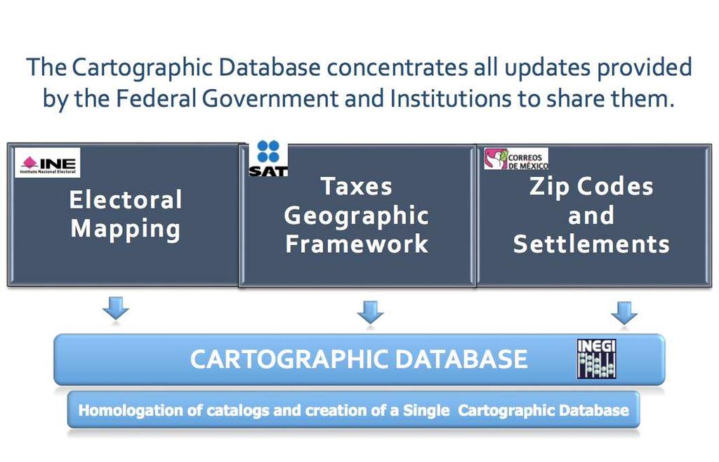
2 INEGI and the National System of Statistical and Geographic Information (SNIEG) Since 2008, INEGI coordinates the SNIEG, which includes all units of the State (Executive, Legislative and Judicial branches, as well as sub-national governments) INEGI is also responsible for the creation, use and promotion of the system s statistical and geographic technical standards. Geographical data are based on International Geospatial Standards. (

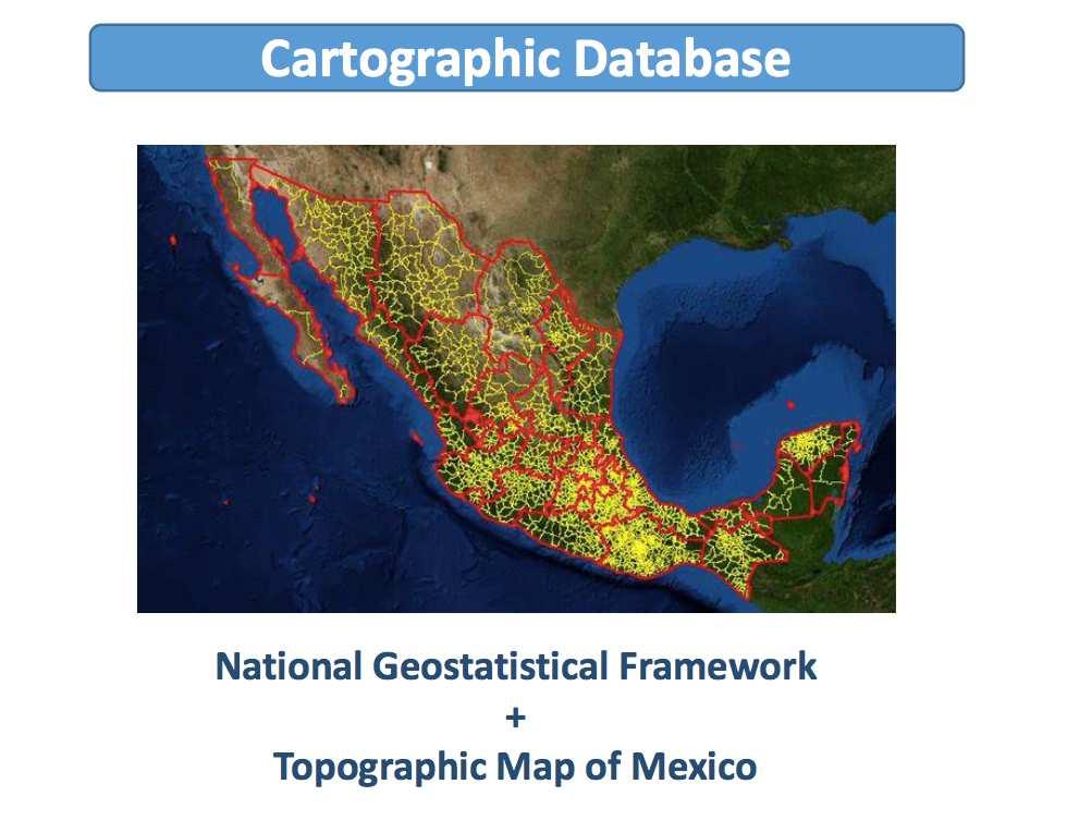
3 Background of the National Geostatistical Framework (MGN) In Mexican censuses prior to 1980, cartography was scarce with a diversity of sources, coverage, scales and update dates. This did not guarantee geographical coverage, thus giving rise to the creation of a geographic reference framework for the collection of statistical information For this reason, INEGI created in 1978 the National Geostatistical Framework (MGN), which is a system that allows to correctly reference the statistical information of censuses and surveys in the corresponding geographic locations.
 Basic (AGEB) The AGEB constitute the fundamental unit of the framework, which is adjusted as much as possible, to the politicaladministrative limits of the country.")
4 National Geostatistical Framework (MGN) The MGN divides the national territory into areas of easy identification in the field, these units are called Geostatistical Areas and are: State (AGEE) Municipalities (AGEM) Basic (AGEB) The AGEB constitute the fundamental unit of the framework, which is adjusted as much as possible, to the politicaladministrative limits of the country. They are also divided by urban and rural.
5 Levels of the National Geostatistical Framework The Urban AGEB delimit a part or the total of a locality of 2,500 inhabitants or more, or, a municipal head. These are made up of a set of city blocks. The Rural AGEBs cover an area of approximately 10,000 hectares, whose land use is predominantly agricultural and in them are localities smaller than 2,500 inhabitants.


6 Through the linking of information, the entire system can use a single geostatistical framework; To link statistical and geographic information, updated maps are provided to the divisions of socio-demographic statistics, economic statistics and government/justice statistics; These maps are resolved at the city block level, and they identify roads, traffic lights, and other landmarks or public services. These multi-layered maps are used to regularly update the Geo-statistical Framework and the Single Cartographic Database

7 New UrbanCartographicDatabase Oriented to update the cartography of urban areas, where 71% of the population is concentrated. It includes 783 formats, at a scale of 1:20,000


8 New UrbanCartographicDatabase Urban Cartography for the generation of Urban Statistics Santitation pit/well Traffic light Power line post Hydraulic pit/well Light post Wheelchair ramp


9 Updating trough the Agricultural Census 2017 Data capture using mobile computing devices Satellite Images Mapping Questionnaire Catalogs Online validation Producer directory Instructions and manuals


10 ECONOMIC CENSUS (2019)
11 Census Operational Process Our Census Operational Process has 4 modules: Operational Planning 1. Operational Planning 2. Mapping Module 3. Monitoring progress and Geographical coverage 4. Closure.

12 Operational Planning Module Module 1: Operational Planning 1. Based on the Digital Map of Mexico. This web application optimizes the operational planning of the event by assigning control sections of graphic form, and managing operating figures and graphical assignation of weekly work with a systematic visual monitoring of control sections, with a constant data backup every 15 minutes.
13 Mapping Module Module 2: Mapping Module Cartographic udpate 2. Some applications of this module areto create and modify the mapping efficiently, easily and quickly to collect information in an accurate and complete way (merge or split blocks, roads, rural localities-creation, service-creation, or modifying services). To allow for the capture of land data, blocks, services, and roads to keep updated those databases that require it.

14 Monitoring, progress and geographical coverage module Module 3: Monitoring, progress and geographical coverage 3. The tracking system is a web application that allows the integration of information and facilitates the monitoring of progress and geographical coverage by using the tools that allow a better analysis of the integrated information. The packages are integrated consistently, so that once it reaches the central server, the system is updated with a delay of minutes.


15 Closure Module Module 4: Closure Influence areas KML Format Cross layers 4. Closure Module. Spatial Analysis example: You can create influence areas and make crossings with other layers of information and download it on KML and quantify the information in the analysis area.


16 Economic Census Atlas National Directory of Economic Units (DENUE) Total economic units by state Data from economic units (commercial establishments) Total economic units, by block (Mexico City)


17 POPULATION AND HOUSING CENSUS Geo-referencing through the use of GPS in mobile devices
18 Use of cartographyin censusoperations Traditionally, geo-statistical coding has been used to link geographic and statistical information Traditionally, INEGI has used cartography to geo-reference census information. Recently, GPS technology has been successfully used to update economic information, through the Economic Census. GPS technology will again be tested in 2019, during a trial run for the 2020 Population and Housing Census. The expectation is that the 2020 Census will fully incorporate this technology, for a more effective integration of statistical and geographic information.


19 Cartographic Updates through the trace of areas with GPS coordinates Methodology 1. Do a recon test run of assigned routes 2. Identify city blocks through cartographic updates 3. Enable the reading of geographic coordinates through GPS, during the course of the run through the areas and perimeters being updated. 4. Run the routes and mark thecoordinates, for future geographic reference of both surveyors and supervisors


20 Route run and validation using GPS coordinates 5. The supervisor goes through route, registering the questionnaire and the GPS coordinates 6. Surveyor then applies questionnaire to each dwelling in route 7. Validation through matching of coordinates and buffers This method would ensure the capture of all dwellings coordinates during the course of the surveyor s route.
21
22
23 Environmental information


24 Environmental Information integration of statistics, administrative records, and geospatial information Fotografías de Elementos Georreferenciados
25 Participatory Cartography An interactive, dynamic crowd-sourcing process to channel citizen input for territorial information used to permanently update and improve official cartography. Discrepancies or updates in addresses and roadways (numbering, nomenclature, senses, services and status updates during emergencies) Inputs: comments, pictures and other formats Input is validated by INEGI specialists and uploaded to the Digital Map of Mexico or the Collaborative Disaster Platform.
")

26 Damages after Hurricane Patricia (Oct 2015)
27
28 The 5 guiding principles of the GSGF are aligned with Mexico s Geostatistical Framework Principle 5: accessible and usable geospatially enabled statistics. 5. Publication and free use of the Digital Map of Mexico / Free download of cartographic products Principle 4: interoperable data and metadata standards Principle 3: common geographies for dissemination of statistics 4. Online services that allow the exchange and use of information / Application of the Technical Standard for the elaboration of Geographical Metadata 3. Use of a unique Geostatistical Framework allows to have an infrastructure for the Statistical Information Subsystems Principle 2: geocoded unit record data in a data management environment 2. Geostatistical Framework / Spatial Data Infrastructure / Administrative Records Principle 1: use of fundamental geospatial infrastructure and geocoding 1. Topographic Chart / Geodetic Network / National Road Network / Catalogs: Geostatistical Areas, Roads, Localities, Services, Natural Resources


29 Digital Map of Mexico Open-source geomatic platfrom that allows the visualization and analysis of geographic and georeferenced statistical information. It contains 208 vector data layers, with more than 71 million geographic objects and 4 raster layers covering the entire country.

30 National Gender Atlas 46 Gender-related indicators (geo-referenced) 10 main areas: General population Education Health Labor Decision making Use of time Poverty Entrepreneurship Violence % Indigenous population ECLAC UN-Women INEGI Plans to scale it to the regional level Latin America and the Caribbean


 Visualized")
31 Socio-economic Indicators SDG 1 -No poverty Indicator Proportion of the population living in households with acces to basic services Source: National Housing Inventory (geo-referenced) Visualized within the Digital Map of Mexico


32 Socio-economic Indicators SDG 2. End hunger and achieve food security Indicator Volume of production per labour unit Weekly crop monitoring During a drought using satellite imagery Vigorous Sinaloa, Mexico Semi-dry Dry
33 Socio-economic & gender-related indicators Indicator Geographic coverage Source Disaggregation 1. Percentage of population performing unpaid work 2. Average number of hours devoted to unpaid work e.g. Domestic, care for children, elderly or disabled National, states and municipality Population census Economic census Inter-census surveys Age / age groups Gender Location Type of activity/care Gender Atlas Linked to SDG indicators Proportion of time spent on unpaid domestic and care work, by sex, age and location (tier II)
34 Gender-related Indicators Indicator Geographic coverage Source Disaggregation 1. Prevalence of violence (physical or sexual) against women Total Age-specific, childhood, throughout life National, states and municipality Population census Inter-census surveys Administrative records Gender Atlas Age Gender Location Marital status Linked to SDG indicators: Proportion of ever-partnered women and girls aged 15 years and older subjected to physical, sexual or psychological violence by a current or former intimate partner in the previous 12 months, by form of violence and by age (tier II) Proportion of women and girls aged 15 years and older subjected to sexual violence by persons other than an intimate partner in the previous 12 months, by age and place of occurrence (tier II)

35 Socio-economic Indicators SDG 8. Promote sustained, inclusive and sustainable economic growth, full and productive employment and decent work for all Indicator8.3.1 Share of informal employment in non-agriculture employment by gender Sources: National Employment Survey visualized within the Digital Map of Mexico


36 Environmental Indicators SDG 15. Life on land Indicator Forest area as a percentage of total land area Indicator Progress towards sustainable forest management Source: INEGI s Land Use and Vegetation Map Series Visualized in the Digital Map of Mexico (various scales available) 36


37 Environmental Indicators SDG 15. Lifeon land Target 2: By 2020, promote the implementation of sustainable management of all types of forests, halt deforestation, restore degraded forests and substantially increase afforestation and reforestation globally Indicator Net permanent forest loss Changes in tropical broadleaf evergreen forest can be estimated Marqués de Comillas, Chiapas Satellite images (from 2006 and 2013). 37
38 Government & Justice Indicators Indicator Geographic coverage Source Disaggregati on National Results Percentage of the population aged 18 and over that have been victims of corruption (Populationaged18andoverwhowerevictimsofcorruptioninatleast one procedure, payment or service made personally / Population of 18 years and over who performed at least one procedure, payment or request for service personally with a public official) x 100 National and by federal entity (states) National Survey of Quality and Government Impact Georeferenced These indicators measure experiences with acts of corruption in the interaction with public officials SDG Indicator Proportion of persons who had at least one contact with a public official, and who paid a bribe to a public official, or were asked for a bribe by those public officials, during the previous 12 months Link to public policy: National Anti-Corruption System
39 Government & Justice Indicators Indicator Geographic coverage Source Disaggregation National Results Percentage of population aged 18 and over satisfied with basic public services, by type of service. (Population aged 18 and over who is satisfied with basic public services / Population aged 18 and over who live in urbanareasof100,000peopleandmore)x100 National by State National Survey of Quality and Government Impact (ENCIG) Garbage collection Drinking water Publicparksand gardens Street lighting Streets and avenues This indicator is associated with measuring quality in the provision of basic public services at the municipal level SDG Indicator Proportion of the population satisfied with their last experience of public services Note: Based on the upcoming ENCIG results, a drainage and sewer service indicator will be included.


40 Calculation of indicator using statistical and geospatial sources Indicator Proportion of the rural population who live within 2km of an all-season road National Topographic Data Set 1:50,000.


41 The National Council for Sustainable Development and Agenda 2030 Created by Executive Decree, and formally installed on April 26, 2017 Conceived as a State-wide, long-term commitment at the highest level, transcending individual administrations It includes 18 line ministries, state and local governments, Congress, the private sector, academia and civil society; Decree includes modifications to the National Development Planning Law, as well as to the 2018 national budget, in order to include provisions for SDG implementation.


42 National Online Platform for the SDGs
43
44 INEGI Current Process SQL-Server Database Integrat ed REST Service (API) Review Review Site External Entities Ministries SDG Integration and Maintenance System Replicate Review Database Review Postgres Database Replicate Public Database Publi c Hub SDG MÉXICO REST Service (API) Public SDG Official site
45 INE Proceso GI Automatizado Viable SQL-Server Database Integrat ed REST Service (API) Review Review Site External Entities Ministries SDG Integration and Maintenance System Replicate Review Database Review SDG-GIS Transformati on System Revie w Postgres Database Replicate Public Database Review Publi c Hub SDG MÉXICO REST Service (API) Public Publi c SDG Official site
46 INEGI Ideal Automated Process Statistical Data SQL-Server Database Geographic Data REST Service (API) Review External Entities Ministries Integrat ed Review Site SDG Integration and Maintenance System Replicate Review Database Revie w SDG-GIS Transformati on System Review Review Replicate Public Database Publi c Publi c REST Service (API) Public Hub Update Hub SDG MÉXICO SDG Official site
47
48
49
50 Main challenges Budgetary issues. Most information comes from census and surveys; immense human and financial resources are needed to make them representative across a heterogeneous country, and at the state and municipal levels; Need to improve and integrate administrative records; many gaps, harmonization and digitalization issues remain; Need to make geospatial dimension really cross-cutting, to support the four dimensions of Sustainable Development, as well as throughout SDG reporting.
51 Conclusions Having statistics and geography in a single national institution has allowed Mexico for a better integration and use of complementary information systems; With the associated tools from this integration, it is possible to georeference relevant statistics; Integration determines location of economic and social inequalities, overall needs, as well as risks and damages from natural disasters; The use of integrated geographic and statistical data allows for better design and monitoring of public policies and internationally-agreed goals such as the SDGs.
Creating synergies between Statistical and Geospatial information for better policy outputs: The case of Mexico
 Creating synergies between Statistical and Geospatial information for better policy outputs: The case of Mexico Geospatial & Statistics Integration for Informed Decision Making Geospatial World Forum 2017
Experience of Mexico in using GIS and spatial
 Experience of Mexico in using GIS and spatial data as a tool for data integration Francisco Javier Jimenez Nava Deputy General Director of Natural Resources and Environment Outline Introduction National
Geospatial Enabling Resilient Development. Latin America Geospatial Forum Río de Janeiro September 2013
 Geospatial Enabling Resilient Development Latin America Geospatial Forum Río de Janeiro September 2013 Presentation Index INEGI /SNIEG Geostatistical Frame - Georeferenciation Issues Legal Framework Mexican
Geospatial Information and the SDGs in Mexico: institutional perspectives on urban resilience. Kunming Forum on UN-GGIM May 12, 2017
 Geospatial Information and the SDGs in Mexico: institutional perspectives on urban resilience Kunming Forum on UN-GGIM May 12, 2017 Rolando Ocampo Vice-President, INEGI - MEXICO Contents Institutional
1 ST High Level Forum on United Nations Global Geoespatial Information Management GEOGRAPHIC REFERENCING OF ECONOMIC UNITS. México
 1 ST High Level Forum on United Nations Global Geoespatial Information Management Thematic Seminar 27 October, Korea 2011. GEOGRAPHIC REFERENCING OF ECONOMIC UNITS México CONTENTS Introduction Census Cartography
Key Elements of the Geographical Information System of Mexico *
 UNITED NATIONS E/CONF.99/IP.1 ECONOMIC AND SOCIAL COUNCIL Ninth United Nations Regional Cartographic Conference for the Americas New York, 10-14 August 2009 Item 7(a) of the provisional agenda Strategy,
GEOGRAPHIC INFORMATION SYSTEMS Session 8
 GEOGRAPHIC INFORMATION SYSTEMS Session 8 Introduction Geography underpins all activities associated with a census Census geography is essential to plan and manage fieldwork as well as to report results
8 th Meeting of IAEG-SDGs 5 8 November 2018, Stockholm, Sweden. Meetings. Report
 Meetings 8 th Meeting of IAEG-SDGs Between April 2018 and November 2018, the Working Group on Geospatial Information of the IAEG- SDGs held two online meetings; presented a report to the United Nations
Digital Map of Mexico Platform and MxSIG. March 2017
 Digital Map of Mexico Platform and MxSIG March 2017 1 I. Digital Map of Mexico Platform Concept Evolution II. Digital Map of Mexico online Concept Capabilities Information available Other state units information
Institute of Statistical and Geographical Information of Jalisco State Geospatial Technologies, platforms and services at a subnational level
 Institute of Statistical and Geographical Information of Jalisco State Geospatial Technologies, platforms and services at a subnational level México, November 2017 Unique organization in its type SDG 17.18:
Brazil Paper for the. Second Preparatory Meeting of the Proposed United Nations Committee of Experts on Global Geographic Information Management
 Brazil Paper for the Second Preparatory Meeting of the Proposed United Nations Committee of Experts on Global Geographic Information Management on Data Integration Introduction The quick development of
Institute of Statistical and Geographical Information of Jalisco State Subnational Statistical and Geographical System India.
 Institute of Statistical and Geographical Information of Jalisco State Subnational Statistical and Geographical System India. January 2017 Subnational Statistical and Geographical System National Statistical
Disaster Management & Recovery Framework: The Surveyors Response
 Disaster Management & Recovery Framework: The Surveyors Response Greg Scott Inter-Regional Advisor Global Geospatial Information Management United Nations Statistics Division Department of Economic and
Foundation Geospatial Information to serve National and Global Priorities
 Foundation Geospatial Information to serve National and Global Priorities Greg Scott Inter-Regional Advisor Global Geospatial Information Management United Nations Statistics Division UN-GGIM: A global
Set-up of subnational statistical systems Statistical Development Strategy for the State of Jalisco México, 2016
 Set-up of subnational statistical systems Statistical Development Strategy for the State of Jalisco México, 2016 Statistical and Geographical Information Institute of Jalisco (IIEG) 2013. Merger of three
2018/1 The integration of statistical and geospatial information. The Regional Committee of UN-GGIM: Americas:
 The following are the conclusions and recommendations of the Regional Committee of the United Nations on Global Geospatial Information Management for the Americas, during its Fifth Session, Thursday 8
Integration for Informed Decision Making
 Geospatial and Statistics Policy Intervention: Integration for Informed Decision Making Greg Scott Global Geospatial Information Management United Nations Statistics Division Department of Economic and
Common geographies for dissemination of SDG Indicators
 5 th High Level Forum on United Nations GGIM, Mexico 2017 Common geographies for dissemination of SDG Indicators Understanding statistical and geodetic division of territory Janusz Dygaszewicz Central
Use of administrative registers for strengthening the geostatistical framework of the Census of Agriculture in Mexico
 Use of administrative registers for strengthening the geostatistical framework of the Census of Agriculture in Mexico Susana Pérez INEGI, Dirección de Censos y Encuestas Agropecuarias. Avenida José María
National assessment on member s readiness to produce indicators
 Inter-Agency and Expert Group on the Sustainable Development Goal Indicators WORKING GROUP ON GEOSPATIAL INFORMATION Fifth expert meeting 5 and 8 December 2018 8 th Meeting of IAEG-SDGs 5 8 November 2018,
Welcome. C o n n e c t i n g
 Welcome C o n n e c t i n g YOU D i s c i p l i n e s Why is This Meeting......So Important Now? OUR WORLD Is Increasingly Challenged The Evidence Is Clear We Need Better Understanding and More Collaboration
Integrating Official Statistics and Geospatial Information NBS Experience
 Integrating Official Statistics and Geospatial Information NBS Experience Presented by Eng. Reda AL Sabbagh Director of IT Dept. Prepared by Eng. Adham Makky GIS Specialist Topics to be covered: Background
Preparing the GEOGRAPHY for the 2011 Population Census of South Africa
 Preparing the GEOGRAPHY for the 2011 Population Census of South Africa Sharthi Laldaparsad Statistics South Africa; E-mail: sharthil@statssa.gov.za Abstract: Statistics South Africa (Stats SA) s Geography
THE GLOBAL INDICATOR FRAMEWORK: NEW AND INNOVATIVE METHODS FOR DISAGGREGATIN BY GEOLOCATION
 Parallel Session: Measuring and Monitoring the SDGs: THE GLOBAL INDICATOR FRAMEWORK: NEW AND INNOVATIVE METHODS FOR DISAGGREGATIN BY GEOLOCATION from global to regional to national panorama 8 th Meeting
Geospatial Information Management in the Americas: Lessons for the Post-2015 development agenda
 Geospatial Information Management in the Americas: Lessons for the Post-2015 development agenda Rolando Ocampo President, UN-GGIM: Americas October 2014 The integration of statistical and geographical
The Global Statistical Geospatial Framework and the Global Fundamental Geospatial Themes
 The Global Statistical Geospatial Framework and the Global Fundamental Geospatial Themes Sub-regional workshop on integration of administrative data, big data and geospatial information for the compilation
Progress Report. Preamble
 Preamble This report is prepared and submitted to the Inter-agency and Expert Group on Sustainable Development Goal Indicators at its Fifth Meeting held from 28 31 March 2017 in Ottawa, Canada. Background
Qatar Statistical Geospatial Integration
 Qatar Statistical Geospatial Integration A Presentation by the Ministry of Development Planning & Statistics (MDPS), State of Qatar http://www.mdps.gov.qa (Fourth UN-GGIM Arab States Committee Meeting,
Development Of Common Frameworks And Methodologies *
 HIGH LEVEL FORUM ON GLOBAL GEOSPATIAL MANAGEMENT INFORMATION WORKING PAPER No. 9 First Forum Seoul, Republic of Korea, 24-26 October 2011 Development Of Common Frameworks And Methodologies * * Submitted
Principle 3: Common geographies for dissemination of statistics Poland & Canada. Janusz Dygaszewicz Statistics Poland
 Principle 3: Common geographies for dissemination of statistics Poland & Canada Janusz Dygaszewicz Statistics Poland Reference materials Primary: Ortophotomap, Cadastral Data, Administrative division borders,
Geography for the 2020 Round of Census
 Boundaries Key Census Data EA Id Population Male Female EA Id Area EA Id Num HH Avg HH size Geography for the 2020 Round of Census Linda Peters, Esri lpeters@esri.com Integration of Statistical and Geospatial
Presented to Sub-regional workshop on integration of administrative data, big data and geospatial information for the compilation of SDG indicators
 Presented to Sub-regional workshop on integration of administrative data, big data and geospatial information for the compilation of SDG indicators 23-25 April,2018 Addis Ababa, Ethiopia By: Deogratius
Indicator : Average share of the built-up area of cities that is open space for public use for all, by sex, age and persons with disabilities
 Goal 11: Make cities and human settlements inclusive, safe, resilient and sustainable Target 11.7: By 2030, provide universal access to safe, inclusive and accessible, green and public spaces, in particular
Exploring GIS Potential for Northwestern Ontario Land Information Ontario
 Exploring GIS Potential for Northwestern Ontario Land Information Ontario May 13, 2015 The LIO Vision LIO Vision: That all geographic information about Ontario is fully integrated and accessible LIO Goal:
Spanish national plan for land observation: new collaborative production system in Europe
 ADVANCE UNEDITED VERSION UNITED NATIONS E/CONF.103/5/Add.1 Economic and Social Affairs 9 July 2013 Tenth United Nations Regional Cartographic Conference for the Americas New York, 19-23, August 2013 Item
Indicator: Proportion of the rural population who live within 2 km of an all-season road
 Goal: 9 Build resilient infrastructure, promote inclusive and sustainable industrialization and foster innovation Target: 9.1 Develop quality, reliable, sustainable and resilient infrastructure, including
Combining Geospatial and Statistical Data for Analysis & Dissemination
 Combining Geospatial and Statistical Data for Analysis & Dissemination (with Special Reference to Qatar Census 2010) Presentation by Mansoor Al Malki, Director of IT Department Qatar Statistics Authority
Indicator 5.4.1: Proportion of time spent on unpaid domestic and care work, by sex, age and location
 Goal 5: Achieve gender equality and empower all women and girls Target 5.4: Recognize and value unpaid care and domestic work through the provision of public services, infrastructure and social protection
THE ROLE OF GEOSPATIAL AT THE WORLD BANK
 THE ROLE OF GEOSPATIAL AT THE WORLD BANK INSPIRE Conference Barcelona, Spain September 26, 2016 Kathrine Kelm Senior Land Administration Specialist Global Land and Geospatial Unit The World Bank Group
Compact guides GISCO. Geographic information system of the Commission
 Compact guides GISCO Geographic information system of the Commission What is GISCO? GISCO, the Geographic Information System of the COmmission, is a permanent service of Eurostat that fulfils the requirements
Understanding China Census Data with GIS By Shuming Bao and Susan Haynie China Data Center, University of Michigan
 Understanding China Census Data with GIS By Shuming Bao and Susan Haynie China Data Center, University of Michigan The Census data for China provides comprehensive demographic and business information
Evaluating e-government : implementing GIS services in Municipality
 Evaluating e-government : implementing GIS services in Municipality Municipality of Thessaloniki - G.I.S. Unit Misirloglou Symeon Head of the GIS Unit ESRI UC - 2016 The GIS Section - subset of the department
Spatial Statistical Information Services in KOSTAT
 Distr. GENERAL WP.30 12 April 2010 ENGLISH ONLY UNITED NATIONS ECONOMIC COMMISSION FOR EUROPE (UNECE) CONFERENCE OF EUROPEAN STATISTICIANS EUROPEAN COMMISSION STATISTICAL OFFICE OF THE EUROPEAN UNION (EUROSTAT)
Economic and Social Council
 United Nations Economic and Social Council Distr.: General 18 July 2016 Original: English Committee of Experts on Global Geospatial Information Management Sixth session New York, 3-5 August 2016 Item 2
Measuring Disaster Risk for Urban areas in Asia-Pacific
 Measuring Disaster Risk for Urban areas in Asia-Pacific Acknowledgement: Trevor Clifford, Intl Consultant 1 SDG 11 Make cities and human settlements inclusive, safe, resilient and sustainable 11.1: By
Regional Training Workshop on Human Settlement Indicators
 Regional Training Workshop on Human Settlement Indicators Module 6 Indicator 11.7.1: Average share of the built-up area of cities that is open space for public use for all, by sex, age and persons with
Corporate. Information. Railway Infrastructure Administrator. Year indracompany.com
 geospatial and mobility Corporate Geographic Information System of ADIF Railway Infrastructure Administrator. Year 2009-2010 Corporate Geographic Information System of ADIF ADIF. Spanish Administrator
Second Administrative Level Boundaries (SALB) initiative & geographic names in cartography. Geospatial Information Section
 initiative & geographic names in cartography. Geospatial Information Section") Second Administrative Level Boundaries (SALB) initiative & geographic names in cartography Geospatial Information Section Introduction Goals Global agenda How does SALB work? Latest News on geographic
Second Administrative Level Boundaries (SALB) initiative & geographic names in cartography Geospatial Information Section Introduction Goals Global agenda How does SALB work? Latest News on geographic
INDONESIA S S UPDATE: GEOSPATIAL INFORMATION FOR SUSTAINABLE DEVELOPMENT RELATED TO INA SDI Dr. Asep Karsidi, M.Sc
 INDONESIA S S UPDATE: GEOSPATIAL INFORMATION FOR SUSTAINABLE DEVELOPMENT RELATED TO INA SDI Dr. Asep Karsidi, M.Sc GEOSPATIAL INFORMATION AGENCY 08 August, 2012 OUTLINE 1. Transformation Bakosurtanal into
Building a National Data Repository
 Building a National Data Repository Mladen Stojic, Vice President - Geospatial 1/30/2013 2012 Intergraph Corporation 1 Information has meaning and gives power only when shared and distributed. Information,
Land Use in the context of sustainable, smart and inclusive growth
 Land Use in the context of sustainable, smart and inclusive growth François Salgé Ministry of sustainable development France facilitator EUROGI vice president AFIGéO board member 1 Introduction e-content+
Department of Statistics Malaysia
 Department of Statistics Malaysia 1 2 1 2 3 4 5 Introduction Geographic Information Systems (GIS) Geospatial activities for 2020 Modernisation Way Forward 3 Malaysia Population (Millions) Census 2010 2018
GROUP ON INTEGRATION OF STATISTICAL AND GEOSPATIAL INFORMATION GT-IIEG
 UN-GGIM: Americas WORKING GROUP ON INTEGRATION OF STATISTICAL AND GEOSPATIAL INFORMATION GT-IIEG Bogotá, Colombia August, 2018 www.dane.gov.co Working group GT-IIEG Objective: To raise awareness and promote
The Process of Spatial Data Harmonization in Italy. Geom. Paola Ronzino
 The Process of Spatial Data Harmonization in Italy Geom. Paola Ronzino ISSUES Geospatial Information in Europe: lack of data harmonization the lack of data duplication of data CHALLENGES Challenge of INSPIRE:
Globally Estimating the Population Characteristics of Small Geographic Areas. Tom Fitzwater
 Globally Estimating the Population Characteristics of Small Geographic Areas Tom Fitzwater U.S. Census Bureau Population Division What we know 2 Where do people live? Difficult to measure and quantify.
Challenges in Geospatial Policy Formulation and Programme Management
 Challenges in Geospatial Policy Formulation and Programme Management Luiz Paulo Souto Fortes, PhD An Exchange with the Geospatial Industry for UN-GGIM Seoul, October 23, 2011 BRAZIL Land area 8,514,876.599
ADMINISTRATION OF GEOGRAPHICAL NAMES IN URUGUAY
 ADMINISTRATION OF GEOGRAPHICAL NAMES IN URUGUAY 1st. Lt. Julio C. Teixeira Executive Officer Geodesy & Topography Division Military Geographic Service Av. 8 de Octubre 3255. Montevideo, URUGUAY Telph.:
National SDG Data Hubs: Statistical integration and geographic disaggregation (Philippines)
") National SDG Data Hubs: Statistical integration and geographic disaggregation (Philippines) 5 th High Level Forum on United Nations Global Geospatial Information Management Implementing the Sustainable
National SDG Data Hubs: Statistical integration and geographic disaggregation (Philippines) 5 th High Level Forum on United Nations Global Geospatial Information Management Implementing the Sustainable
KUNMING FORUM ON UNITED NATIONS GLOBAL GEOSPATIAL INFORMATION MANAGEMENT CITIES OF THE FUTURE: SMART, RESILIENT
 KUNMING FORUM ON UNITED NATIONS GLOBAL GEOSPATIAL INFORMATION MANAGEMENT CITIES OF THE FUTURE: SMART, RESILIENT and SUSTAINABLE Yunnan Zhenzhuang Guest House, Kunming, China 10 12 May 2017 BACKGROUND CONCEPT
Geospatial information integration for city management and development in Rio de Janeiro
 Geospatial information integration for city management and Leandro Gomes Souza Geographer Luiz Roberto Arueira da Silva Director of City Information Pereira Passos Institute - City of Rio de Janeiro About
ACTION PLAN FOR WORLD HERITAGE IN LATIN AMERICA AND THE CARIBBEAN ( )
") Annex ACTION PLAN FOR WORLD HERITAGE IN LATIN AMERICA AND THE CARIBBEAN (2014-2024) The current Regional Action Plan for Latin America and the Caribbean for 2014-2024 has been elaborated by the State Parties
Annex ACTION PLAN FOR WORLD HERITAGE IN LATIN AMERICA AND THE CARIBBEAN (2014-2024) The current Regional Action Plan for Latin America and the Caribbean for 2014-2024 has been elaborated by the State Parties
ENV208/ENV508 Applied GIS. Week 1: What is GIS?
 ENV208/ENV508 Applied GIS Week 1: What is GIS? 1 WHAT IS GIS? A GIS integrates hardware, software, and data for capturing, managing, analyzing, and displaying all forms of geographically referenced information.
SDI DEVELOPMENT UPDATES OF INDONESIA
 SDI DEVELOPMENT UPDATES OF INDONESIA DR. ANTONIUS B. WIJANARTO Center For Management And Dissemination Of Geospatial Information GEOSPATIAL INFORMATION AUTHORITY GOVERNMENT OF THE REPUBLIC OF INDONESIA
Economic and Social Council
 United Nations Economic and Social Council Distr.: General 2 July 2012 E/C.20/2012/10/Add.1 Original: English Committee of Experts on Global Geospatial Information Management Second session New York, 13-15
GIS FOR MAZOWSZE REGION - GENERAL OUTLINE
 GIS FOR MAZOWSZE REGION - GENERAL OUTLINE S. Bialousz 1), K Mączewski 2), E. Janczar 2), K. Osinska-Skotak 1) 1) Warsaw University of Technology, Warsaw, Poland 2) Office of the Surveyor of the Mazowieckie
Global Geospatial Information Management Country Report Finland. Submitted by Director General Jarmo Ratia, National Land Survey
 Global Geospatial Information Management Country Report Finland Submitted by Director General Jarmo Ratia, National Land Survey Global Geospatial Information Management Country Report Finland Background
Rules of the territorial division
 Rules of the territorial division Janusz Dygaszewicz Central Statistical Office of Poland Jerusalem, 4-7 December 2016 Rules of territory division (the Polish case) The area of each unit of territorial
Achieving the Vision Geo-statistical integration addressing South Africa s Developmental Agenda. geospatial + statistics. The Data Revolution
 Achieving the Vision Geo-statistical integration addressing South Africa s Developmental Agenda geospatial + statistics The Data Revolution humble beginnings, present & future - South Africa UN World Data
The Role of the Louisiana Geographic Information Center in the Response to Hurricane Katrina
 The Role of the Louisiana Geographic Information Center in the Response to Hurricane Katrina By: Jared Chapiewsky & Laura Brown For: URPL 969- GIS Applications in Response to Hurricane Katrina Date: March
BRAZILIAN EXPERIENCE IN USE OF GEORREFERENCING AND REMOTE SENSING IN CENSUS. Brazilian Institute of Geography and Statistics IBGE
 BRAZILIAN EXPERIENCE IN USE OF GEORREFERENCING AND REMOTE SENSING IN CENSUS Brazilian Institute of Geography and Statistics IBGE www.ibge.gov.br 1- INTRODUCTION This paper presents the brazilian experience
Oman NSDI Supporting Economic Development. Saud Al-Nofli Director of Spatial Data Directorate General of NSDI, NCSI
 Oman NSDI Supporting Economic Development 2017 Saud Al-Nofli Director of Spatial Data Directorate General of NSDI, NCSI "It s critical to make correct decisions the first time to optimize the Investments
Land Board, NW Services and SDI Tambet Tiits, FRICS
 Land Board, NW Services and SDI Tambet Tiits, FRICS 07.09.2016 200th anniversary of the Struve Geodetic Arc Friedrich Georg Wilhelm Struve and Carl Friedrich Tenner Struve Geodetic Arc The Struve Geodetic
Upgrade the Datasets in NSDI for Smarter Services with the Cases of China
 Upgrade the Datasets in NSDI for Smarter Services with the Cases of China By Dr. JIANG Jie Dept of GeoInformaiton Service Platform National Geomatics Center of China October 7, 2015 Jeju, Republic of Korea
UN GGIM and National SDI Strategy
 MSDI Open Forum on 26 th January 2016 Contributing to the successful delivery of MSDI UN GGIM and National SDI Strategy Hiroshi Murakami Deputy Administrator Geospatial Information Authority of Japan Geospatial
Second High Level Forum on GGIM Seminar on Regional Cooperation in Geospatial Information Management Doha, Qatar, 7 February 2013
 Second High Level Forum on GGIM Seminar on Regional Cooperation in Geospatial Information Management Doha, Qatar, 7 February 2013 Overview on Geospatial Activities in Egypt BY : Eng.Nahla Seddik Mohamed
June 19 Huntsville, Alabama 1
 June 19 Huntsville, Alabama 1 Real-Time Geospatial Data: The Fusion of PI and ArcGIS Enabling Smarter Facilities Management OSIsoft and Esri Mapping and Location Analytics Platform Supporting Your Use
CONSTRUCTING THE POVERTY AND OPPORTUNITIES/PUBLIC SERVICES MAPS INFORMATION MANAGEMENT. Background: Brazil Without Extreme Poverty Plan
 INFORMATION MANAGEMENT CONSTRUCTING THE POVERTY AND OPPORTUNITIES/PUBLIC SERVICES MAPS Background: Brazil Without Extreme Poverty Plan The Brazil Without Extreme Poverty Plan (BSM), designed to overcome
Improving rural statistics. Defining rural territories and key indicators of rural development
 Improving rural statistics Defining rural territories and key indicators of rural development Improving rural statistics Improving Rural Statistics In 2016, the Global Strategy to improve Agricultural
RESOLUTION NO
 RESOLUTION NO. 09-2017 Adopting Job Descriptions for Engineering and GIS Manager and GIS Analyst and Amending the Pay Resolution to Accommodate Said Positions and Amending the Staffing Chart to Accommodate
Exploit your geodata to enable smart cities and countries
 Exploit your geodata to enable smart cities and countries Carsten Rönsdorf, Head of Advisory Services Middle East Practice Manager Future Cities, standards and 3D 24 November 2014 Importance of Standards
Merging statistics and geospatial information
 Merging statistics and geospatial information Demography / Commuting / Spatial planning / Registers Mirosław Migacz Chief GIS Specialist Janusz Dygaszewicz Director Central Statistical Office of Poland
Gis for Land Management: An Overview on Italy
 Gis for Land Management: An Overview on Italy Paola RONZINO, Italy Key words: Cartography, Land Management, Spatial Planning, Urban Renewal, Spatial Information, Environment SUMMARY The introduction of
GIS ADMINISTRATOR / WEB DEVELOPER EVANSVILLE-VANDERBURGH COUNTY AREA PLAN COMMISSION
 GIS ADMINISTRATOR / WEB DEVELOPER EVANSVILLE-VANDERBURGH COUNTY AREA PLAN COMMISSION SALARY RANGE INITIATION $43,277 SIX MONTHS $45,367 POSITION GRADE PAT VI The Evansville-Vanderburgh County Area Plan
ArcGIS for Desktop. ArcGIS for Desktop is the primary authoring tool for the ArcGIS platform.
 ArcGIS for Desktop ArcGIS for Desktop ArcGIS for Desktop is the primary authoring tool for the ArcGIS platform. Beyond showing your data as points on a map, ArcGIS for Desktop gives you the power to manage
Geospatial SDI Portal for effective Governance of Pune METROPOLIS region
 Geospatial SDI Portal for effective Governance of Pune METROPOLIS region Mr. Praveen Gautam Senior Manager 19 th January 2018 PMRDA Overview Provide a Spatial Framework for the entire region with various
GIS Building Communities beyond National Borders (Building Successful Spatial Data Infrastructures) Nick Land, ESRI Europe
 Nick Land, ESRI Europe") GIS Building Communities beyond National Borders (Building Successful Spatial Data Infrastructures) Nick Land, ESRI Europe UK worst flooding in the last 60 years 350,000 households without drinking water
GIS Building Communities beyond National Borders (Building Successful Spatial Data Infrastructures) Nick Land, ESRI Europe UK worst flooding in the last 60 years 350,000 households without drinking water
IAEG SDGs WG GI, , Mexico City
 IAEG SDGs WG GI, 12-14.12.2016, Mexico City UN-GGIM:Europe s perspective and activities to support better integration of geospatial information and statistics and the UN SDG monitoring Pier-Giorgio Zaccheddu,
Working with Census Operations Case Study from KSA
 Working with Census Operations Case Study from KSA International Workshop on Integrating Geospatial and Statistical Information Beijing 9 12 June 2014 Abdullah M.Alhamlan Kingdom of Saudi Arabia Central
KENYA NATIONAL BUREAU OF STATISTICS Workshop on
 KENYA NATIONAL BUREAU OF STATISTICS Workshop on Capacity Building in Environment Statistics: the Framework for the Development of Environment Statistics (FDES 2013) Coordination with Sector Ministries
Digitization in a Census
 Topics Connectivity of Geographic Data Sketch Maps Data Organization and Geodatabases Managing a Digitization Project Quality and Control Topology Metadata 1 Topics (continued) Interactive Selection Snapping
Sustainable and Harmonised Development for Smart Cities The Role of Geospatial Reference Data. Peter Creuzer
 Sustainable and Harmonised Development for Smart Cities The Role of Geospatial Reference Data Peter Creuzer 1. Introduction - Smart Cities and Geodata 2. Geodata in Germany 3. Examples 4. Data and Service
Demographic Data in ArcGIS. Harry J. Moore IV
 Demographic Data in ArcGIS Harry J. Moore IV Outline What is demographic data? Esri Demographic data - Real world examples with GIS - Redistricting - Emergency Preparedness - Economic Development Next
Leverage of Geospatial and other information sources in Mexico: an institutional perspective on urban resilience
 Leverage of Geospatial and other information sources in Mexico: an institutional perspective on urban resilience Eduardo de la Torre INEGI - MEXICO Kunming Forum on UN-GGIM May 10, 2017 Cities are where
Poverty and Hazard Linkages
 Poverty and Hazard Linkages Global Risk Identification Programme Proposal Development Coordination Meeting Friday, 19 May 2006 CIESIN Earth Institute Columbia University www.ciesin.columbia.edu Data Improvements
Egypt Public DSS. the right of access to information. Mohamed Ramadan, Ph.D. [R&D Advisor to the president of CAPMAS]
![Egypt Public DSS. the right of access to information. Mohamed Ramadan, Ph.D. [R&D Advisor to the president of CAPMAS]](/thumbs/89/98483713.jpg "Egypt Public DSS. the right of access to information. Mohamed Ramadan, Ph.D. [R&D Advisor to the president of CAPMAS]") Egypt Public DSS ì the right of access to information Central Agency for Public Mobilization and Statistics Arab Republic of Egypt Mohamed Ramadan, Ph.D. [R&D Advisor to the president of CAPMAS] Egypt
Egypt Public DSS ì the right of access to information Central Agency for Public Mobilization and Statistics Arab Republic of Egypt Mohamed Ramadan, Ph.D. [R&D Advisor to the president of CAPMAS] Egypt
Preparation of Database for Urban Development
 Preparation of Database for Urban Development By PunyaP OLI, 1. Chairman, ERMC (P) Ltd., Kathmandu, Nepal. Email: punyaoli@ermcnepal.com 2. Coordinator, Himalayan College of Geomatic Engineering and Land
Turkey s National SDI Implementation
 Onur PAŞAOĞULLARI Head of Department Turkey s National SDI Implementation Presentation Plan NSDI Background General Directorate of Geographic Information Systems NSDI Project INSPIRE Directive Urban Information
International Guidelines on Access to Basic Services for All
 International Guidelines on Access to Basic Services for All Presentation and initials lessons from implementation Accessibility to services in regions and cities : measures and policies, OECD 18 June
Geographical Names: Relevance and place within the UN-GGIM framework
 Geographical Names: Relevance and place within the UN-GGIM framework Greg Scott Inter-Regional Advisor Global Geospatial Information Management United Nations Statistics Division UN-GGIM: A global initiative
Basic Act on the Advancement of Utilizing Geospatial Information
 Basic Act on the Advancement of Utilizing Geospatial Information (Act No. 63 of May 30, 2007) Table of Contents Chapter I General Provisions (Articles 1 to 8) Chapter II Basic Plan for the Advancement