patersongroup Environmental Noise Control Study Proposed Multi-Storey Building 1088 Maritime Way - Ottawa Prepared For
|
|
|
- Byron Campbell
- 5 years ago
- Views:
Transcription
1 Geotechnical Engineering patersongroup Environmental Engineering Hydrogeology Geological Engineering Materials Testing Building Science Archaeological Services Environmental Noise Control Study Proposed Multi-Storey Building 1088 Maritime Way - Ottawa Prepared For Canadian Rental Development Services Inc. Paterson Group Inc. Consulting Engineers 154 Colonnade Road South Ottawa (Nepean), Ontario Canada K2E 7J5 Tel: (613) Fax: (613) February 10, 2017 Report: PG Ottawa Kingston North Bay
2 patersongroup Ottawa Kingston North Bay Environmental Noise Control Study Proposed Multi-Storey Building 1088 Maritime Way - Ottawa Table of Contents Page 1.0 Introduction Background Methodology and Noise Assessment Analysis Results Discussion and Recommendations 6.1 Outdoor Living Areas Indoor Living Areas and Ventilation Noise Control Measures for Surface Transportation Noise Statement of Limitations Appendices Appendix 1 Appendix 2 Table 8 - Summary of Reception Points and Geometry Drawing PG Site Plan Drawing PG Receptor Locations STAMSON Results Appendix 3 Shop Drawings Report: PG February 10, 2017 Page i
3 patersongroup Ottawa Kingston North Bay Environmental Noise Control Study Proposed Multi-Storey Building 1088 Maritime Way - Ottawa 1.0 Introduction Paterson Group (Paterson) was commissioned by Canadian Rental Development Services Inc to conduct an environmental noise control study for the proposed multistorey building to be located at 1088 Maritime Way, in the City of Ottawa (refer to Figure 1 - Key Plan in Appendix 2 of this report). The objective of the current study was to: Determine the primary noise sources impacting the site and compare the projected sound levels to guidelines set out by the Ministry of Environment and Climate Change (MOECC) and the City of Ottawa. Review the projected noise levels and offer recommendations regarding warning classes, construction materials or alternative sound barriers. The following report has been prepared specifically and solely for the aforementioned project which is described herein. It contains our findings and includes acoustical recommendations pertaining to the design and construction of the subject development as they are understood at the time of writing this report. This study has been conducted according to the City of Ottawa s document - Engineering Noise Control Guidelines (ENCG), dated January 2016, and the Ontario Ministry of the Environment Guideline NPC Background It is understood that the proposed development will consist of a six (6) storey residential building with two (2) levels of underground parking. It is noted that a common terrace is located on 4 th floor, in addition to several other personal terraces located on the 3 rd, 4 th and 5 th floor. Report: PG February 10, 2017 Page 1
4 patersongroup Ottawa Kingston North Bay Environmental Noise Control Study Proposed Multi-Storey Building 1088 Maritime Way - Ottawa 3.0 Methodology and Noise Assessment Criteria The City of Ottawa outlines three (3) sources of environmental noise that must be analyzed separately: Surface Transportation Noise Stationary Noise new noise-sensitive development applications (noise receptors) in proximity to existing or approved stationary sources of noise, and new stationary sources of noise (noise generating) in proximity to existing or approved noise-sensitive developments Aircraft noise Surface Transportation Noise The City of Ottawa s Official Plan, in addition to the ENCG dictate that the following conditions must be satisfied to classify as a surface transportation noise source for a subject site: Within 100 m of the right-of-way of an existing or proposed arterial, collector or major collector road; a light rail transit corridor; bus rapid transit, or transit priority corridor Within 250 m of the right-of-way for an existing or proposed highway or secondary rail line Within 300 m from the right of way of a proposed or existing rail corridor or a secondary main railway line Within 500 m of an existing 400 series provincial highway, freeway or principle main railway line. The NPC-300 outlines the limitations of the stationary and environmental noise levels in relation to the location of the receptors. These can be found in the following tables: Table 1 - Sound Level Limits for Outdoor Living Areas Time Period Required L eq(16) (dba) 16-hour, 7:00-23:00 55 Standards taken from Table 2.2a; Sound Level Limit for Outdoor Living Areas - Road and Rail Report: PG February 10, 2017 Page 2
5 patersongroup Ottawa Kingston North Bay Environmental Noise Control Study Proposed Multi-Storey Building 1088 Maritime Way - Ottawa Table 2 - Sound Level Limits for Indoor Living Area Type of Space Time Period Required L eq (dba) Road Rail Living/Dining, den areas of residences, hospitals, nursing homes, schools, daycare centres, etc Theaters, place of worship, libraries, individual or semiprivate offices, conference rooms, reading rooms Sleeping quarters 7:00-23: :00-7: :00-23: :00-7: Standards taken from Table 2.2b; Sound Level Limit for Indoor Living Areas - Road and Rail If the sound level limits are exceeded at the window panes for the indoor living areas, the following Warning Clauses may be referenced: Table 3 - Warning Clauses for Sound Level Exceedances Warning Clause Warning Clause Type A Warning Clause Type B Warning Clause Type C Warning Clause Type D Description "Purchasers/tenants are advised that sound levels due to increasing road traffic (rail traffic) (air traffic) may occasionally interfere with some activities of the dwelling occupants as the sound levels exceed the sound level limits of the Municipality and the Ministry of the Environment." "Purchasers/tenants are advised that despite the inclusion of noise control features in the development and within the building units, sound levels due to increasing road traffic (rail traffic) (air traffic) may on occasions interfere with some activities of the dwelling occupants as the sound levels exceed the sound level limits of the Municipality and the Ministry of the Environment." "This dwelling unit has been designed with the provision for adding central air conditioning at the occupant's discretion. Installation of central air conditioning by the occupant in low and medium density developments will allow windows and exterior doors to remain closed, thereby ensuring that the indoor sound levels are within the sound level limits of the Municipality and the Ministry of the Environment." "This dwelling unit has been supplied with a central air conditioning system which will allow windows and exterior doors to remain closed, thereby ensuring that the indoor sound levels are within the sound level limits of the Municipality and the Ministry of the Environment." Clauses taken from section C8 Warning Clauses; Environmental Noise Guidelines - NPC- 300 Report: PG February 10, 2017 Page 3
6 patersongroup Ottawa Kingston North Bay Environmental Noise Control Study Proposed Multi-Storey Building 1088 Maritime Way - Ottawa Stationary Noise Stationary noise sources include sources or facilities that are fixed or mobile and can cause a combination of sound and vibration levels emitted beyond the property line. These sources may include commercial air conditioner units, generators and fans. Facilities that may contribute to stationary noise may include car washes, snow disposal sites, transit stations and manufacturing facilities. The impact of stationary noise sources are directly related to the location of the subject site within the urban environment. The proposed development at 1088 Maritime Way can be classified as Class 1 by provincial guidelines and outlined in the ENGC, meaning an area with an acoustical environment typical of a major population centre, where the background sound level is dominated by the activities of people, usually road traffic, often referred to as urban hum. Within the City Class 1 areas generally include all of the urban area as well as lands in proximity to Employment Lands and the 416/417 corridor. Table 4 - Guidelines for Stationary Noise - Class 1 Time of Day Outdoor Point of Reception Pane of Window 7:00-19: :00-23: :00-7:00-45 Standards taken from Table 3.2a; Guidelines for Stationary Noise - Steady and Varying Sound Aircraft/Airport Noise Aircraft noise is distinct, as it is typically low frequency for longer durations. The sound level may also differ between different types of aircraft. Due to the location of the subject site, an analysis aircraft/airport noise is not required. Report: PG February 10, 2017 Page 4
7 patersongroup Ottawa Kingston North Bay Environmental Noise Control Study Proposed Multi-Storey Building 1088 Maritime Way - Ottawa 4.0 Analysis The proposed development is bordered by Campeau Drive, Maritime Way, Knudson Drive and Gray Crescent. Provincial Highway 417 is located to the south, within the 500 m of the proposed building. However, only Campeau Drive (urban arterial roadway) and the Provincial Highway 417 (400 series highway) are included in this study. Noise sources are presented on Paterson Drawing PG Site Plan, located in Appendix 1. There are no stationary noise sources or aircraft noise within the influence area. The noise levels from road traffic are provided by the City of Ottawa, taking into consideration the right-of-way width and the implied roadway class. It is understood that these values represent the maximum allowable capacity of the proposed roadways. Campeau Drive is classified as a 2-lane urban arterial (2-UAU). The Provincial Highway 417 is classified as a freeway. At the location of the development, the Highway 417 is considered a 5 lane highway in both the eastbound and westbound directions. For this analysis, the Highway 417 will be split into the eastbound Highway 417 and the westbound Highway 417. The parameters to be used for sound level predictions can be found below. Table 5 - Traffic and Road Parameters Road Implied Roadway AADT (Veh/day) Posted Speed (km/h) Day/Night Split % Medium Truck % Heavy Truck % Campeau Drive 2-UAU 15, /8 7 5 Highway 417 Freeway, Queensway 18,333 per lane /8 7 5 Data obtained from the City of Ottawa document ENCG There were several reception points that were considered for a thorough analysis of the proposed multi-storey building. An Outdoor Living Area (OLA) was noted on the 4 th floor. The point of assessment of the OLA is in the centre of the terrace, 1.5 m above the floor level. The analysis is completed so that no effects of sound reflection off of the building facade is considered, as stipulated by the ENGC. Due to the presence of the OLA, the individual terraces do not need their separate reception points and the results of the OLA is sufficient. Report: PG February 10, 2017 Page 5
8 patersongroup Ottawa Kingston North Bay Environmental Noise Control Study Proposed Multi-Storey Building 1088 Maritime Way - Ottawa Additional reception points were selected at the bedroom windows at different building elevations. For this analysis, a reception point was taken at the centre of the window pane, at several different elevations, on each wall of the proposed development. Reception points are noted on Paterson Drawing PG Receptor Locations, located in Appendix 1. Table 8 - Summary of Reception Points and Geometry, located in Appendix 1, provides a summary of the points of reception and their geometry with respect to the noise sources. The analysis was completed using STAMSON version 5.04, a computer program which uses the road and rail traffic noise prediction methods using ORNAMENT (Ontario Road Noise Analysis Method for Environment and Transportation) and STEAM (Sound from Trains Environment Analysis Method), publications from the Ontario Ministry of Environment and Energy. Report: PG February 10, 2017 Page 6
9 patersongroup Ottawa Kingston North Bay Environmental Noise Control Study Proposed Multi-Storey Building 1088 Maritime Way - Ottawa 5.0 Results The primary descriptors are the 16-hour daytime and the 8-hour night time equivalent sound levels, L eq(16) and the L eq(8) for City roads. The proposed traffic noise levels were analyzed at all reception points. The results of the STAMSON software can be located in Appendix 2, and the summary of the results can be noted in Table 6. Table 6 - Proposed Noise Levels Reception Point Description OLA L EQ(16) (dba) Daytime at Facade L EQ(16) (dba) Nighttime at Facade L eq(8) (dba) REC 1-1 North elevation, 1 st floor n/a REC 1-3 North elevation, 3 rd floor n/a REC 1-6 North elevation, 6 th floor n/a REC 2-1 Northeast elevation, 1 st floor n/a REC 2-3 Northeast elevation, 3 rd floor n/a REC 3-1 Southeast elevation, 1 st floor n/a REC 3-3 Southeast elevation, 3 rd floor n/a REC 4-1 South elevation, 1 st floor n/a REC 4-3 South elevation, 3 rd floor n/a REC 4-6 South elevation, 6 th floor n/a REC 5-1 West elevation, 1 st floor n/a REC 5-3 West elevation, 3 rd floor n/a REC 5-6 West elevation, 6 th floor n/a REC 6-4 Outdoor Living Area - 4 th floor n/a n/a Report: PG February 10, 2017 Page 7
10 patersongroup Ottawa Kingston North Bay Environmental Noise Control Study Proposed Multi-Storey Building 1088 Maritime Way - Ottawa 6.0 Discussion and Recommendations 6.1 Outdoor Living Areas The outdoor living area is located on the northern elevation, on the 4 th floor terrace. A noise analysis was performed for this location, specified as REC 6-4. Based on drawings provided to Paterson by Canadian Rental Development Services Inc, the 4 th floor will be approximately 14.5 m above the final ground surface. The point analyzed is located in the centre of the terrace, 1.5 m above the fourth floor level, with the assumption that the proposed building will act as a sound barrier for transportation noise along Campeau Drive. The results of the STAMSON modeling indicates that the L eq(16) from all sources will be dba. This value is below the 55 dba that was specified in Table 1. Therefore, this location is considered acceptable as specified. There are no other outdoor living areas indicated for analysis. 6.2 Indoor Living Areas and Ventilation The results of the STAMSON modelling indicates that the L eq(16) ranges between dba and dba. These values exceed the limit of 45 dba as specified in Table 2 and therefore warning clauses will be required to be stated on any property titles. The applicable warning clauses are summarized in Table 7 on the following page. Report: PG February 10, 2017 Page 8
11 patersongroup Ottawa Kingston North Bay Environmental Noise Control Study Proposed Multi-Storey Building 1088 Maritime Way - Ottawa Table 7 - Summary of Warning Clauses Elevation Floor Applicable Warning Clause Warning 1 st -5 th Clause Type C Additional Considerations All units must be equipped with a central air conditioning system, reducing the need to open windows. North Warning 6 th Clause Type D All units must be equipped with a central air conditioning system, reducing the need to open windows. Additionally, building components including windows, walls and doors, where applicable, should be designed so that the indoor sound levels comply with the sound level limits in Table 2. Northeast 1 st -3 rd Clause Warning Type C Warning 1 st -2 nd Clause Type C All units must be equipped with a central air conditioning system, reducing the need to open windows. All units must be equipped with a central air conditioning system, reducing the need to open windows. Southeast South West Warning 3 rd Clause Type D 1 st -2 nd Warning Clause Type C Warning 3 rd -6 th Clause Type D Warning 1 st -4 th Clause Type C Warning 5 th -6 th Clause Type D All units must be equipped with a central air conditioning system, reducing the need to open windows. Additionally, building components including windows, walls and doors, where applicable, should be designed so that the indoor sound levels comply with the sound level limits in Table 2. All units must be equipped with a central air conditioning system, reducing the need to open windows. All units must be equipped with a central air conditioning system, reducing the need to open windows. Additionally, building components including windows, walls and doors, where applicable, should be designed so that the indoor sound levels comply with the sound level limits in Table 2. All units must be equipped with a central air conditioning system, reducing the need to open windows. All units must be equipped with a central air conditioning system, reducing the need to open windows. Additionally, building components including windows, walls and doors, where applicable, should be designed so that the indoor sound levels comply with the sound level limits in Table 2. Report: PG February 10, 2017 Page 9
12 patersongroup Ottawa Kingston North Bay Environmental Noise Control Study Proposed Multi-Storey Building 1088 Maritime Way - Ottawa 6.3 Noise Control Measures for Surface Transportation Noise As described in Table 7, where the daytime sound level at the plane of the window exceeds 65 dba, as noted on the 6 th floor of the north elevation, 3 rd floor and above of the southern elevation, and 6 th floor of the western elevation, noise control measures should be implemented. The MOECC, lists the following options for sound mitigation: Distance set back with soft ground Insertion of noise insensitive land uses between the source and sensitive receptor Orientation of buildings to provide sheltered zones or modified interior spaces (room and corridor arrangement) and amenity areas Enhanced construction techniques and construction quality (e.g. brick veneers, multi-pane windows). Earth berms (sound barriers) Indoor isolation - air conditioning and ventilation, enhanced dampening materials (indoor isolation) It should be noted that it is not possible to provide additional set-backs with soft ground from the identified noise sources and the orientation of the building has already been positions to minimize the amount of noise on any outdoor living areas. Therefore, the sound mitigation method that will be implemented for this proposed development will include a review of the construction techniques and construction materials. It is not anticipated that earth berms or sound barriers will be required for this development. Proposed Construction Specifications Canadian Rental Development provided Paterson with typical window and wall details with construction specifications and materials for the subject building. The typical window and wall details are included in Appendix 3. Report: PG February 10, 2017 Page 10
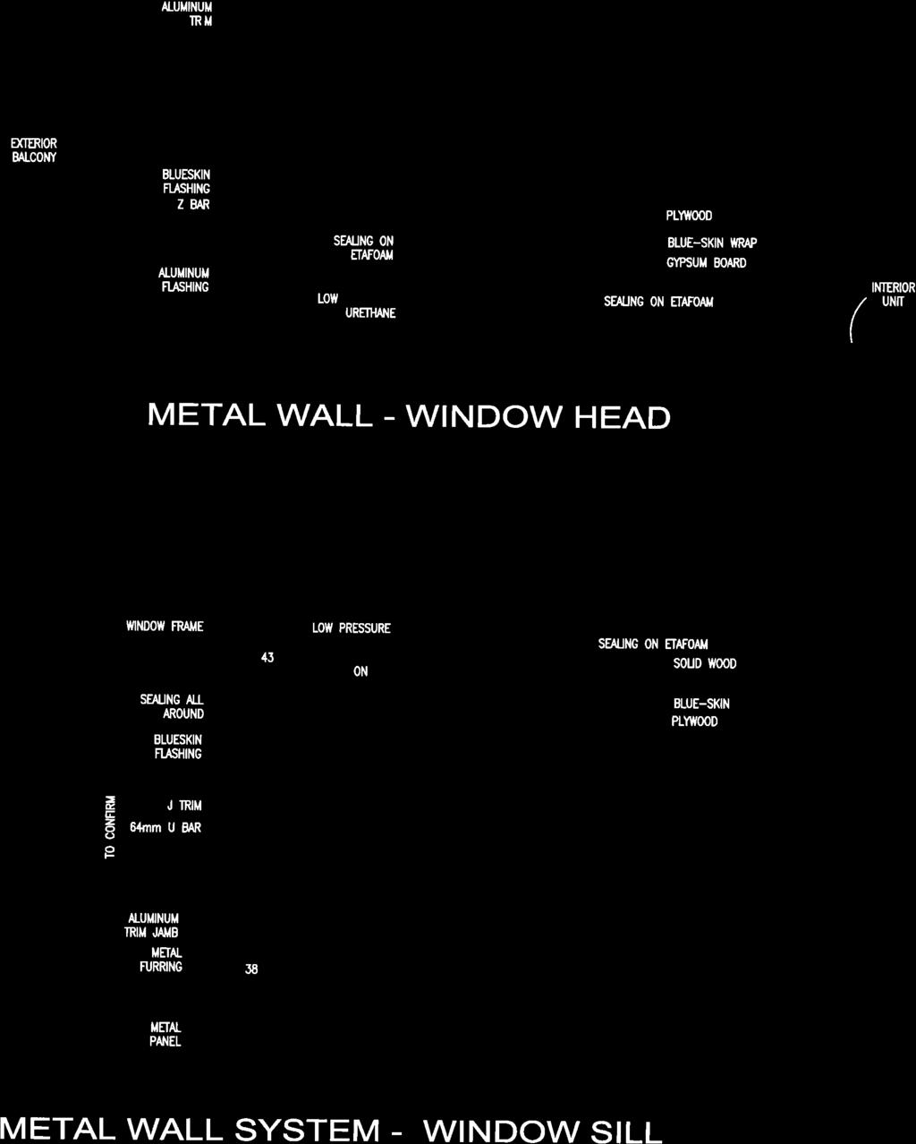
13 patersongroup Ottawa Kingston North Bay Environmental Noise Control Study Proposed Multi-Storey Building 1088 Maritime Way - Ottawa Exterior Wall Specifications It is understood that the exterior metal panel wall will consist of a WT1 Type. The specifics of this assembly are summarized below: Longboard 13 mm metal panel 22 mm vertical m etal furring 64 mm z bar system 64 mm cavity rock DD BLU SKIN V.P mm Densglass 150 mm metal stud 100 mm spread insulation 15.9 gypsum board type X Externals Window Specifications It is understood that the exterior windows will consist of a double glaze, aluminum window casement. The manufacturer specifications are located in Appendix 3 with the specifics of this assembly summarized below: Double glaze window 6 mm glass ply 13 mm air space It is understood, from manufacturer specifications, that this window assembly will provide a Sound Transmission Class (STC) of 35. The STC rating generally relates to the amount of decibel reduction that the specified material provides. Building Component Sound Reduction Discussion As described in Table 7, where the daytime sound level at the plane of the window exceeds 65 dba, building components should be designed to reduce the amount of sound in the living areas. Report: PG February 10, 2017 Page 11
14 patersongroup Ottawa Kingston North Bay Environmental Noise Control Study Proposed Multi-Storey Building 1088 Maritime Way - Ottawa Due to the construction methods for both the exterior walls and the window assembly, the window assembly will be the limiting factor that allows sound from the exterior to the interior of the units, as compared to the exterior wall construction. The maximum decibel value for this building was noted on the south elevation of the 6 th floor, calculated at dba during the day and dba during the evening. The proposed window assembly, and, in extension, the window assembly and exterior wall construction, will provide sufficient sound reduction to ensure that the interior of the units will remain at or below 45 dba, provided that windows and/or patio doors remain closed. Report: PG February 10, 2017 Page 12

 other than the Canadian Rental Development Services Inc or their agent(s) is not authorized without review by this")
15 patersongroup Ottawa Kingston North Bay Environmental Noise Control Study Proposed Multi-Storey Building 1088 Maritime Way - Ottawa 7.0 Statement of Limitations The recommendations made in this report are in accordance with our present understanding of the project. Our recommendations should be reviewed when the project drawings and specifications are complete. The present report applies only to the project described in this document. Use of this report for purposes other than those described herein or by person(s) other than the Canadian Rental Development Services Inc or their agent(s) is not authorized without review by this firm for the applicability of our recommendations to the altered use of the report. Paterson Group Inc. Stephanie A. Boisvenue, P.Eng. David J. Gilbert, P.Eng. Report Distribution: Canadian Rental Development Services Inc. (3 copies) Paterson Group (1 copy) Report: PG February 10, 2017 Page 13
16 APPENDIX 1 TABLE 8 - SUMMARY OF RECEPTION POINTS AND GEOMETRY DRAWING PG SITE PLAN DRAWING PG RECEPTOR LOCATIONS
17 Table 8 - Summary of Reception Points and Geometry 1088 Maritime Way Leq Campeau Drive Highway 417 Point of Location Day Horizontal Vertical Total Local Angle Barrier Height Distance Horizontal Vertical Total Local Angle Barrier Height Distance elevation Reception (dba) (m) (m) (m) (degree) (m) (m) West/East (m) (m) (m) (degree) (m) (m) (m) REC 1-1 north elevation , 90 n/a n/a n/a n/a n/a n/a n/a n/a n/a REC 1-3 north elevation , 90 n/a n/a n/a n/a n/a n/a n/a n/a n/a REC 1-6 north elevation , 90 n/a n/a n/a n/a n/a n/a n/a n/a n/a REC 2-1 REC 2-3 REC 3-1 REC 3-3 northeast elevation northeast elevation southeast elevation southeast elevation , 72 0, 72 0, 38 0, 38 n/a n/a n/a n/a n/a no no no 324/ / / / / / / /284-90,-14-90,-14-90,-24-90, , 90 72, 90 38, 90 38, / / / / / / / /284-14, 0-14, 0-24, 28-24, 28 n/a n/a n/a n/a n/a n/a n/a n/a n/a n/a n/a n/a n/a n/a 280/ /300-90, REC 4-1 south elevation n/a n/a n/a n/a n/a n/a 280/ /300-31, 41 n/a n/a 4 n/a n/a n/a n/a n/a n/a 280/ /300 41, n/a n/a n/a n/a n/a n/a 280/ /300-90, REC 4-3 south elevation n/a n/a n/a n/a n/a n/a 280/ /300-31, 41 n/a n/a 4 n/a n/a n/a n/a n/a n/a 280/ /300 41, n/a n/a n/a n/a n/a n/a 280/ /301-90, REC 4-6 south elevation n/a n/a n/a n/a n/a n/a 280/ /301-31, 41 n/a n/a 4 n/a n/a n/a n/a n/a n/a 280/ /301 41, REC 5-1 REC 5-3 REC 5-6 west elevation west elevation west elevation ,-35-90,-35-90, / / / / / /346 0, 14 0, 14 0, 14 n/a n/a n/a n/a n/a n/a , 0-35, 0-35, 0 n/a n/a n/a n/a n/a n/a 300/ / / / / /346 14, 90 14, 90 14, REC 6-4 northwest (OLA) , 78 n/a n/a n/a n/a n/a n/a n/a n/a n/a patersongroup
18
19
20 APPENDIX 2 STAMSON RESULTS
21 REC11.TXT STAMSON 5.0 NORMAL REPORT Date: :07:21 MINISTRY OF ENVIRONMENT AND ENERGY / NOISE ASSESSMENT Filename: REC11.te Description: REC 1-1 Time Period: Day/Night 16/8 hours Road data, segment # 1: Campeau Dr (day/night) Car traffic volume : 12144/1056 veh/timeperiod * Medium truck volume : 966/84 veh/timeperiod * Heavy truck volume : 690/60 veh/timeperiod * Posted speed limit : 60 km/h 24 hr Traffic Volume (AADT or SADT): Data for Segment # 1: Campeau Dr (day/night) Angle1 Angle2 : deg deg Receiver source distance : / m Receiver height : 1.50 / 1.50 m Topography : 1 (Flat/gentle slope; no barrier) Results segment # 1: Campeau Dr (day) - ROAD ( ) = dba Segment Leq : dba Total Leq All Segments: dba Results segment # 1: Campeau Dr (night) --- ROAD ( ) = dba Page 1
22 REC11.TXT Segment Leq : dba Total Leq All Segments: dba TOTAL Leq FROM ALL SOURCES (DAY): (NIGHT): Page 2
23 REC13.TXT STAMSON 5.0 NORMAL REPORT Date: :09:35 MINISTRY OF ENVIRONMENT AND ENERGY / NOISE ASSESSMENT Filename: REC13.te Description: REC 1-3 Time Period: Day/Night 16/8 hours Road data, segment # 1: Campeau Dr (day/night) Car traffic volume : 12144/1056 veh/timeperiod * Medium truck volume : 966/84 veh/timeperiod * Heavy truck volume : 690/60 veh/timeperiod * Posted speed limit : 60 km/h 24 hr Traffic Volume (AADT or SADT): Data for Segment # 1: Campeau Dr (day/night) Angle1 Angle2 : deg deg Receiver source distance : / m Receiver height : 8.50 / 8.50 m Topography : 1 (Flat/gentle slope; no barrier) Results segment # 1: Campeau Dr (day) - ROAD ( ) = dba Segment Leq : dba Total Leq All Segments: dba Results segment # 1: Campeau Dr (night) --- ROAD ( ) = dba Page 1
24 REC13.TXT Segment Leq : dba Total Leq All Segments: dba TOTAL Leq FROM ALL SOURCES (DAY): (NIGHT): Page 2
25 REC16.TXT STAMSON 5.0 NORMAL REPORT Date: :10:33 MINISTRY OF ENVIRONMENT AND ENERGY / NOISE ASSESSMENT Filename: REC16.te Description: REC 1-6 Time Period: Day/Night 16/8 hours Road data, segment # 1: Campeau Dr (day/night) Car traffic volume : 12144/1056 veh/timeperiod * Medium truck volume : 966/84 veh/timeperiod * Heavy truck volume : 690/60 veh/timeperiod * Posted speed limit : 60 km/h 24 hr Traffic Volume (AADT or SADT): Data for Segment # 1: Campeau Dr (day/night) Angle1 Angle2 : deg deg Receiver source distance : / m Receiver height : / m Topography : 1 (Flat/gentle slope; no barrier) Results segment # 1: Campeau Dr (day) - ROAD ( ) = dba Segment Leq : dba Total Leq All Segments: dba Results segment # 1: Campeau Dr (night) --- ROAD ( ) = dba Page 1
26 REC16.TXT Segment Leq : dba Total Leq All Segments: dba TOTAL Leq FROM ALL SOURCES (DAY): (NIGHT): Page 2
27 REC21.TXT STAMSON 5.0 NORMAL REPORT Date: :43:09 MINISTRY OF ENVIRONMENT AND ENERGY / NOISE ASSESSMENT Filename: rec21.te Description: REC 2-1 Time Period: Day/Night 16/8 hours Road data, segment # 1: Campeau Dr (day/night) Car traffic volume : 12144/1056 veh/timeperiod * Medium truck volume : 966/84 veh/timeperiod * Heavy truck volume : 690/60 veh/timeperiod * Posted speed limit : 60 km/h 24 hr Traffic Volume (AADT or SADT): Data for Segment # 1: Campeau Dr (day/night) Angle1 Angle2 : 0.00 deg deg Receiver source distance : / m Receiver height : 1.50 / 1.50 m Topography : 1 (Flat/gentle slope; no barrier) Road data, segment # 2: Campeau Dr (day/night) Car traffic volume : 12144/1056 veh/timeperiod * Medium truck volume : 966/84 veh/timeperiod * Heavy truck volume : 690/60 veh/timeperiod * Posted speed limit : 60 km/h 24 hr Traffic Volume (AADT or SADT): Data for Segment # 2: Campeau Dr (day/night) Angle1 Angle2 : deg deg Receiver source distance : / m Receiver height : 1.50 / 1.50 m Page 1
28 REC21.TXT Topography : 2 (Flat/gentle slope; with barrier) Barrier angle1 : deg Angle2 : deg Barrier height : 5.25 m Barrier receiver distance : / m Source elevation : 0.00 m Receiver elevation : 0.00 m Barrier elevation : 0.00 m Road data, segment # 3: Hwy 417 West (day/night) Car traffic volume : 74212/6453 veh/timeperiod * Medium truck volume : 5903/513 veh/timeperiod * Heavy truck volume : 4217/367 veh/timeperiod * Posted speed limit : 100 km/h 24 hr Traffic Volume (AADT or SADT): Data for Segment # 3: Hwy 417 West (day/night) Angle1 Angle2 : deg deg Receiver source distance : / m Receiver height : 1.50 / 1.50 m Topography : 4 (Elevated; with barrier) Barrier angle1 : deg Angle2 : deg Barrier height : 5.25 m Elevation : 4.00 m Barrier receiver distance : / m Source elevation : 0.00 m Receiver elevation : 4.00 m Barrier elevation : 2.00 m Road data, segment # 4: Hwy 417 West (day/night) Car traffic volume : 74212/6453 veh/timeperiod * Medium truck volume : 5903/513 veh/timeperiod * Heavy truck volume : 4217/367 veh/timeperiod * Posted speed limit : 100 km/h 24 hr Traffic Volume (AADT or SADT): Page 2
29 REC21.TXT Data for Segment # 4: Hwy 417 West (day/night) Angle1 Angle2 : deg 0.00 deg Receiver source distance : / m Receiver height : 1.50 / 1.50 m Topography : 3 (Elevated; no barrier) Elevation : 4.00 m Road data, segment # 5: Hwy 417 East (day/night) Car traffic volume : 74212/6453 veh/timeperiod * Medium truck volume : 5903/513 veh/timeperiod * Heavy truck volume : 4217/367 veh/timeperiod * Posted speed limit : 100 km/h 24 hr Traffic Volume (AADT or SADT): Data for Segment # 5: Hwy 417 East (day/night) Angle1 Angle2 : deg deg Receiver source distance : / m Receiver height : 1.50 / 1.50 m Topography : 4 (Elevated; with barrier) Barrier angle1 : deg Angle2 : deg Barrier height : 5.25 m Elevation : 4.00 m Barrier receiver distance : / m Source elevation : 0.00 m Receiver elevation : 4.00 m Barrier elevation : 2.00 m Road data, segment # 6: Hwy 417 East (day/night) Car traffic volume : 74212/6453 veh/timeperiod * Medium truck volume : 5903/513 veh/timeperiod * Heavy truck volume : 4217/367 veh/timeperiod * Posted speed limit : 100 km/h Page 3
30 REC21.TXT 24 hr Traffic Volume (AADT or SADT): Data for Segment # 6: Hwy 417 East (day/night) Angle1 Angle2 : deg 0.00 deg Receiver source distance : / m Receiver height : 1.50 / 1.50 m Topography : 3 (Elevated; no barrier) Elevation : 4.00 m Results segment # 1: Campeau Dr (day) - ROAD ( ) = dba Segment Leq : dba Results segment # 2: Campeau Dr (day) ! 1.50! 1.50! 1.50 ROAD ( ) = dba Segment Leq : dba Results segment # 3: Hwy 417 West (day) --- Page 4
31 REC21.TXT 1.50! 1.50! 0.34! 2.34 ROAD ( ) = dba Segment Leq : dba Results segment # 4: Hwy 417 West (day) --- ROAD ( ) = dba Segment Leq : dba Results segment # 5: Hwy 417 East (day) ! 1.50! 0.68! 2.68 ROAD ( ) = dba Segment Leq : dba Results segment # 6: Hwy 417 East (day) --- ROAD ( ) = dba Segment Leq : dba Total Leq All Segments: dba Page 5
32 REC21.TXT Results segment # 1: Campeau Dr (night) --- ROAD ( ) = dba Segment Leq : dba Results segment # 2: Campeau Dr (night) ! 1.50! 1.50! 1.50 ROAD ( ) = dba Segment Leq : dba Results segment # 3: Hwy 417 West (night) ! 1.50! 0.34! 2.34 ROAD ( ) = dba Segment Leq : dba Results segment # 4: Hwy 417 West (night) ROAD ( ) = dba Page 6
33 REC21.TXT Segment Leq : dba Results segment # 5: Hwy 417 East (night) ! 1.50! 0.68! 2.68 ROAD ( ) = dba Segment Leq : dba Results segment # 6: Hwy 417 East (night) ROAD ( ) = dba Segment Leq : dba Total Leq All Segments: dba TOTAL Leq FROM ALL SOURCES (DAY): (NIGHT): Page 7
34 REC23.TXT STAMSON 5.0 NORMAL REPORT Date: :44:45 MINISTRY OF ENVIRONMENT AND ENERGY / NOISE ASSESSMENT Filename: rec23.te Description: REC 2-3 Time Period: Day/Night 16/8 hours Road data, segment # 1: Campeau Dr (day/night) Car traffic volume : 12144/1056 veh/timeperiod * Medium truck volume : 966/84 veh/timeperiod * Heavy truck volume : 690/60 veh/timeperiod * Posted speed limit : 60 km/h 24 hr Traffic Volume (AADT or SADT): Data for Segment # 1: Campeau Dr (day/night) Angle1 Angle2 : 0.00 deg deg Receiver source distance : / m Receiver height : 8.50 / 8.50 m Topography : 1 (Flat/gentle slope; no barrier) Road data, segment # 2: Campeau Dr (day/night) Car traffic volume : 12144/1056 veh/timeperiod * Medium truck volume : 966/84 veh/timeperiod * Heavy truck volume : 690/60 veh/timeperiod * Posted speed limit : 60 km/h 24 hr Traffic Volume (AADT or SADT): Data for Segment # 2: Campeau Dr (day/night) Angle1 Angle2 : deg deg Receiver source distance : / m Receiver height : 8.50 / 8.50 m Page 1
35 REC23.TXT Topography : 2 (Flat/gentle slope; with barrier) Barrier angle1 : deg Angle2 : deg Barrier height : 5.25 m Barrier receiver distance : / m Source elevation : 0.00 m Receiver elevation : 0.00 m Barrier elevation : 0.00 m Road data, segment # 3: Hwy 417 West (day/night) Car traffic volume : 74212/6453 veh/timeperiod * Medium truck volume : 5903/513 veh/timeperiod * Heavy truck volume : 4217/367 veh/timeperiod * Posted speed limit : 100 km/h 24 hr Traffic Volume (AADT or SADT): Data for Segment # 3: Hwy 417 West (day/night) Angle1 Angle2 : deg deg Receiver source distance : / m Receiver height : 8.50 / 8.50 m Topography : 4 (Elevated; with barrier) Barrier angle1 : deg Angle2 : deg Barrier height : 5.25 m Elevation : 4.00 m Barrier receiver distance : / m Source elevation : 0.00 m Receiver elevation : 4.00 m Barrier elevation : 2.00 m Road data, segment # 4: Hwy 417 West (day/night) Car traffic volume : 74212/6453 veh/timeperiod * Medium truck volume : 5903/513 veh/timeperiod * Heavy truck volume : 4217/367 veh/timeperiod * Posted speed limit : 100 km/h 24 hr Traffic Volume (AADT or SADT): Page 2
36 REC23.TXT Data for Segment # 4: Hwy 417 West (day/night) Angle1 Angle2 : deg 0.00 deg Receiver source distance : / m Receiver height : 8.50 / 8.50 m Topography : 3 (Elevated; no barrier) Elevation : 4.00 m Road data, segment # 5: Hwy 417 East (day/night) Car traffic volume : 74212/6453 veh/timeperiod * Medium truck volume : 5903/513 veh/timeperiod * Heavy truck volume : 4217/367 veh/timeperiod * Posted speed limit : 100 km/h 24 hr Traffic Volume (AADT or SADT): Data for Segment # 5: Hwy 417 East (day/night) Angle1 Angle2 : deg deg Receiver source distance : / m Receiver height : 8.50 / 8.50 m Topography : 4 (Elevated; with barrier) Barrier angle1 : deg Angle2 : deg Barrier height : 5.25 m Elevation : 4.00 m Barrier receiver distance : / m Source elevation : 0.00 m Receiver elevation : 4.00 m Barrier elevation : 2.00 m Road data, segment # 6: Hwy 417 East (day/night) Car traffic volume : 74212/6453 veh/timeperiod * Medium truck volume : 5903/513 veh/timeperiod * Heavy truck volume : 4217/367 veh/timeperiod * Posted speed limit : 100 km/h Page 3
37 REC23.TXT 24 hr Traffic Volume (AADT or SADT): Data for Segment # 6: Hwy 417 East (day/night) Angle1 Angle2 : deg 0.00 deg Receiver source distance : / m Receiver height : 8.50 / 8.50 m Topography : 3 (Elevated; no barrier) Elevation : 4.00 m Results segment # 1: Campeau Dr (day) - ROAD ( ) = dba Segment Leq : dba Results segment # 2: Campeau Dr (day) ! 8.50! 2.77! 2.77 ROAD ( ) = dba Segment Leq : dba Results segment # 3: Hwy 417 West (day) --- Page 4
38 REC23.TXT 1.50! 8.50! 1.80! 3.80 ROAD ( ) = dba Segment Leq : dba Results segment # 4: Hwy 417 West (day) --- ROAD ( ) = dba Segment Leq : dba Results segment # 5: Hwy 417 East (day) ! 8.50! 2.76! 4.76 ROAD ( ) = dba Segment Leq : dba Results segment # 6: Hwy 417 East (day) --- ROAD ( ) = dba Segment Leq : dba Total Leq All Segments: dba Page 5
39 REC23.TXT Results segment # 1: Campeau Dr (night) --- ROAD ( ) = dba Segment Leq : dba Results segment # 2: Campeau Dr (night) ! 8.50! 2.77! 2.77 ROAD ( ) = dba Segment Leq : dba Results segment # 3: Hwy 417 West (night) ! 8.50! 1.81! 3.81 ROAD ( ) = dba Segment Leq : dba Results segment # 4: Hwy 417 West (night) ROAD ( ) = dba Page 6
40 REC23.TXT Segment Leq : dba Results segment # 5: Hwy 417 East (night) ! 8.50! 2.76! 4.76 ROAD ( ) = dba Segment Leq : dba Results segment # 6: Hwy 417 East (night) ROAD ( ) = dba Segment Leq : dba Total Leq All Segments: dba TOTAL Leq FROM ALL SOURCES (DAY): (NIGHT): Page 7
41 REC31.TXT STAMSON 5.0 NORMAL REPORT Date: :47:26 MINISTRY OF ENVIRONMENT AND ENERGY / NOISE ASSESSMENT Filename: rec31.te Description: REC 3-1 Time Period: Day/Night 16/8 hours Road data, segment # 1: Campeau Dr (day/night) Car traffic volume : 12144/1056 veh/timeperiod * Medium truck volume : 966/84 veh/timeperiod * Heavy truck volume : 690/60 veh/timeperiod * Posted speed limit : 60 km/h 24 hr Traffic Volume (AADT or SADT): Data for Segment # 1: Campeau Dr (day/night) Angle1 Angle2 : 0.00 deg deg Receiver source distance : / m Receiver height : 1.50 / 1.50 m Topography : 1 (Flat/gentle slope; no barrier) Road data, segment # 2: Campeau Dr (day/night) Car traffic volume : 12144/1056 veh/timeperiod * Medium truck volume : 966/84 veh/timeperiod * Heavy truck volume : 690/60 veh/timeperiod * Posted speed limit : 60 km/h 24 hr Traffic Volume (AADT or SADT): Data for Segment # 2: Campeau Dr (day/night) Angle1 Angle2 : deg deg Receiver source distance : / m Receiver height : 1.50 / 1.50 m Page 1
42 REC31.TXT Topography : 2 (Flat/gentle slope; with barrier) Barrier angle1 : deg Angle2 : deg Barrier height : 5.25 m Barrier receiver distance : / m Source elevation : 0.00 m Receiver elevation : 0.00 m Barrier elevation : 0.00 m Road data, segment # 3: Hwy 417 West (day/night) Car traffic volume : 74212/6453 veh/timeperiod * Medium truck volume : 5903/513 veh/timeperiod * Heavy truck volume : 4217/367 veh/timeperiod * Posted speed limit : 100 km/h 24 hr Traffic Volume (AADT or SADT): Data for Segment # 3: Hwy 417 West (day/night) Angle1 Angle2 : deg deg Receiver source distance : / m Receiver height : 1.50 / 1.50 m Topography : 4 (Elevated; with barrier) Barrier angle1 : deg Angle2 : deg Barrier height : 5.25 m Elevation : 4.00 m Barrier receiver distance : / m Source elevation : 0.00 m Receiver elevation : 4.00 m Barrier elevation : 2.00 m Road data, segment # 4: Hwy 417 West (day/night) Car traffic volume : 74212/6453 veh/timeperiod * Medium truck volume : 5903/513 veh/timeperiod * Heavy truck volume : 4217/367 veh/timeperiod * Posted speed limit : 100 km/h 24 hr Traffic Volume (AADT or SADT): Page 2
43 REC31.TXT Data for Segment # 4: Hwy 417 West (day/night) Angle1 Angle2 : deg deg Receiver source distance : / m Receiver height : 1.50 / 1.50 m Topography : 3 (Elevated; no barrier) Elevation : 4.00 m Road data, segment # 5: Hwy 417 East (day/night) Car traffic volume : 74212/6453 veh/timeperiod * Medium truck volume : 5903/513 veh/timeperiod * Heavy truck volume : 4217/367 veh/timeperiod * Posted speed limit : 100 km/h 24 hr Traffic Volume (AADT or SADT): Data for Segment # 5: Hwy 417 East (day/night) Angle1 Angle2 : deg deg Receiver source distance : / m Receiver height : 1.50 / 1.50 m Topography : 4 (Elevated; with barrier) Barrier angle1 : deg Angle2 : deg Barrier height : 5.25 m Elevation : 4.00 m Barrier receiver distance : / m Source elevation : 0.00 m Receiver elevation : 4.00 m Barrier elevation : 2.00 m Road data, segment # 6: Hwy 417 East (day/night) Car traffic volume : 74212/6453 veh/timeperiod * Medium truck volume : 5903/513 veh/timeperiod * Heavy truck volume : 4217/367 veh/timeperiod * Posted speed limit : 100 km/h Page 3
44 REC31.TXT 24 hr Traffic Volume (AADT or SADT): Data for Segment # 6: Hwy 417 East (day/night) Angle1 Angle2 : deg deg Receiver source distance : / m Receiver height : 1.50 / 1.50 m Topography : 3 (Elevated; no barrier) Elevation : 4.00 m Results segment # 1: Campeau Dr (day) - ROAD ( ) = dba Segment Leq : dba Results segment # 2: Campeau Dr (day) ! 1.50! 1.50! 1.50 ROAD ( ) = dba Segment Leq : dba Results segment # 3: Hwy 417 West (day) --- Page 4
45 REC31.TXT 1.50! 1.50! 0.19! 2.19 ROAD ( ) = dba Segment Leq : dba Results segment # 4: Hwy 417 West (day) --- ROAD ( ) = dba Segment Leq : dba Results segment # 5: Hwy 417 East (day) ! 1.50! 0.68! 2.68 ROAD ( ) = dba Segment Leq : dba Results segment # 6: Hwy 417 East (day) --- ROAD ( ) = dba Segment Leq : dba Total Leq All Segments: dba Page 5
46 REC31.TXT Results segment # 1: Campeau Dr (night) --- ROAD ( ) = dba Segment Leq : dba Results segment # 2: Campeau Dr (night) ! 1.50! 1.50! 1.50 ROAD ( ) = dba Segment Leq : dba Results segment # 3: Hwy 417 West (night) ! 1.50! 0.19! 2.19 ROAD ( ) = dba Segment Leq : dba Results segment # 4: Hwy 417 West (night) ROAD ( ) = dba Page 6
47 REC31.TXT Segment Leq : dba Results segment # 5: Hwy 417 East (night) ! 1.50! 0.68! 2.68 ROAD ( ) = dba Segment Leq : dba Results segment # 6: Hwy 417 East (night) ROAD ( ) = dba Segment Leq : dba Total Leq All Segments: dba TOTAL Leq FROM ALL SOURCES (DAY): (NIGHT): Page 7
48 REC33.TXT STAMSON 5.0 NORMAL REPORT Date: :49:45 MINISTRY OF ENVIRONMENT AND ENERGY / NOISE ASSESSMENT Filename: rec33.te Description: REC 3-3 Time Period: Day/Night 16/8 hours Road data, segment # 1: Campeau Dr (day/night) Car traffic volume : 12144/1056 veh/timeperiod * Medium truck volume : 966/84 veh/timeperiod * Heavy truck volume : 690/60 veh/timeperiod * Posted speed limit : 60 km/h 24 hr Traffic Volume (AADT or SADT): Data for Segment # 1: Campeau Dr (day/night) Angle1 Angle2 : 0.00 deg deg Receiver source distance : / m Receiver height : 8.50 / 8.50 m Topography : 1 (Flat/gentle slope; no barrier) Road data, segment # 2: Campeau Dr (day/night) Car traffic volume : 12144/1056 veh/timeperiod * Medium truck volume : 966/84 veh/timeperiod * Heavy truck volume : 690/60 veh/timeperiod * Posted speed limit : 60 km/h 24 hr Traffic Volume (AADT or SADT): Data for Segment # 2: Campeau Dr (day/night) Angle1 Angle2 : deg deg Receiver source distance : / m Receiver height : 8.50 / 8.50 m Page 1
49 REC33.TXT Topography : 2 (Flat/gentle slope; with barrier) Barrier angle1 : deg Angle2 : deg Barrier height : 5.25 m Barrier receiver distance : / m Source elevation : 0.00 m Receiver elevation : 0.00 m Barrier elevation : 0.00 m Road data, segment # 3: Hwy 417 West (day/night) Car traffic volume : 74212/6453 veh/timeperiod * Medium truck volume : 5903/513 veh/timeperiod * Heavy truck volume : 4217/367 veh/timeperiod * Posted speed limit : 100 km/h 24 hr Traffic Volume (AADT or SADT): Data for Segment # 3: Hwy 417 West (day/night) Angle1 Angle2 : deg deg Receiver source distance : / m Receiver height : 8.50 / 8.50 m Topography : 4 (Elevated; with barrier) Barrier angle1 : deg Angle2 : deg Barrier height : 5.25 m Elevation : 4.00 m Barrier receiver distance : / m Source elevation : 0.00 m Receiver elevation : 4.00 m Barrier elevation : 2.00 m Road data, segment # 4: Hwy 417 West (day/night) Car traffic volume : 74212/6453 veh/timeperiod * Medium truck volume : 5903/513 veh/timeperiod * Heavy truck volume : 4217/367 veh/timeperiod * Posted speed limit : 100 km/h 24 hr Traffic Volume (AADT or SADT): Page 2
50 REC33.TXT Data for Segment # 4: Hwy 417 West (day/night) Angle1 Angle2 : deg deg Receiver source distance : / m Receiver height : 8.50 / 8.50 m Topography : 3 (Elevated; no barrier) Elevation : 4.00 m Road data, segment # 5: Hwy 417 East (day/night) Car traffic volume : 74212/6453 veh/timeperiod * Medium truck volume : 5903/513 veh/timeperiod * Heavy truck volume : 4217/367 veh/timeperiod * Posted speed limit : 100 km/h 24 hr Traffic Volume (AADT or SADT): Data for Segment # 5: Hwy 417 East (day/night) Angle1 Angle2 : deg deg Receiver source distance : / m Receiver height : 8.50 / 8.50 m Topography : 4 (Elevated; with barrier) Barrier angle1 : deg Angle2 : deg Barrier height : 5.25 m Elevation : 4.00 m Barrier receiver distance : / m Source elevation : 0.00 m Receiver elevation : 4.00 m Barrier elevation : 2.00 m Road data, segment # 6: Hwy 417 East (day/night) Car traffic volume : 74212/6453 veh/timeperiod * Medium truck volume : 5903/513 veh/timeperiod * Heavy truck volume : 4217/367 veh/timeperiod * Posted speed limit : 100 km/h Page 3
51 REC33.TXT 24 hr Traffic Volume (AADT or SADT): Data for Segment # 6: Hwy 417 East (day/night) Angle1 Angle2 : deg deg Receiver source distance : / m Receiver height : 8.50 / 8.50 m Topography : 3 (Elevated; no barrier) Elevation : 4.00 m Results segment # 1: Campeau Dr (day) - ROAD ( ) = dba Segment Leq : dba Results segment # 2: Campeau Dr (day) ! 8.50! 6.03! 6.03 ROAD ( ) = dba * * Bright Zone! Segment Leq : dba Results segment # 3: Hwy 417 West (day) --- Page 4
52 REC33.TXT 1.50! 8.50! 1.41! 3.41 ROAD ( ) = dba Segment Leq : dba Results segment # 4: Hwy 417 West (day) --- ROAD ( ) = dba Segment Leq : dba Results segment # 5: Hwy 417 East (day) ! 8.50! 2.75! 4.75 ROAD ( ) = dba Segment Leq : dba Results segment # 6: Hwy 417 East (day) --- ROAD ( ) = dba Segment Leq : dba Page 5
53 REC33.TXT Total Leq All Segments: dba Results segment # 1: Campeau Dr (night) --- ROAD ( ) = dba Segment Leq : dba Results segment # 2: Campeau Dr (night) ! 8.50! 6.03! 6.03 ROAD ( ) = dba * * Bright Zone! Segment Leq : dba Results segment # 3: Hwy 417 West (night) ! 8.50! 1.41! 3.41 ROAD ( ) = dba Segment Leq : dba Page 6
54 REC33.TXT Results segment # 4: Hwy 417 West (night) ROAD ( ) = dba Segment Leq : dba Results segment # 5: Hwy 417 East (night) ! 8.50! 2.75! 4.75 ROAD ( ) = dba Segment Leq : dba Results segment # 6: Hwy 417 East (night) ROAD ( ) = dba Segment Leq : dba Total Leq All Segments: dba TOTAL Leq FROM ALL SOURCES (DAY): (NIGHT): Page 7
55 REC41.TXT STAMSON 5.0 NORMAL REPORT Date: :53:33 MINISTRY OF ENVIRONMENT AND ENERGY / NOISE ASSESSMENT Filename: rec41.te Description: REC 4-1 Time Period: Day/Night 16/8 hours Road data, segment # 1: Hwy 417 West (day/night) Car traffic volume : 74212/6453 veh/timeperiod * Medium truck volume : 5903/513 veh/timeperiod * Heavy truck volume : 4217/367 veh/timeperiod * Posted speed limit : 100 km/h 24 hr Traffic Volume (AADT or SADT): Data for Segment # 1: Hwy 417 West (day/night) Angle1 Angle2 : deg deg Receiver source distance : / m Receiver height : 1.50 / 1.50 m Topography : 4 (Elevated; with barrier) Barrier angle1 : deg Angle2 : deg Barrier height : 5.25 m Elevation : 4.00 m Barrier receiver distance : / m Source elevation : 0.00 m Receiver elevation : 4.00 m Barrier elevation : 2.00 m Road data, segment # 2: Hwy 417 West (day/night) Car traffic volume : 74212/6453 veh/timeperiod * Medium truck volume : 5903/513 veh/timeperiod * Heavy truck volume : 4217/367 veh/timeperiod * Posted speed limit : 100 km/h 24 hr Traffic Volume (AADT or SADT): Data for Segment # 2: Hwy 417 West (day/night) Page 1
56 REC41.TXT Angle1 Angle2 : deg deg Receiver source distance : / m Receiver height : 1.50 / 1.50 m Topography : 3 (Elevated; no barrier) Elevation : 4.00 m Road data, segment # 3: Hwy 417 West (day/night) Car traffic volume : 74212/6453 veh/timeperiod * Medium truck volume : 5903/513 veh/timeperiod * Heavy truck volume : 4217/367 veh/timeperiod * Posted speed limit : 100 km/h 24 hr Traffic Volume (AADT or SADT): Data for Segment # 3: Hwy 417 West (day/night) Angle1 Angle2 : deg deg Receiver source distance : / m Receiver height : 1.50 / 1.50 m Topography : 4 (Elevated; with barrier) Barrier angle1 : deg Angle2 : deg Barrier height : m Elevation : 4.00 m Barrier receiver distance : / m Source elevation : 0.00 m Receiver elevation : 4.00 m Barrier elevation : 3.00 m Road data, segment # 4: Hwy 417 East (day/night) Car traffic volume : 74212/6453 veh/timeperiod * Medium truck volume : 5903/513 veh/timeperiod * Heavy truck volume : 4217/367 veh/timeperiod * Posted speed limit : 100 km/h 24 hr Traffic Volume (AADT or SADT): Page 2
57 REC41.TXT Data for Segment # 4: Hwy 417 East (day/night) Angle1 Angle2 : deg deg Receiver source distance : / m Receiver height : 1.50 / 1.50 m Topography : 4 (Elevated; with barrier) Barrier angle1 : deg Angle2 : deg Barrier height : 5.25 m Elevation : 4.00 m Barrier receiver distance : / m Source elevation : 0.00 m Receiver elevation : 0.00 m Barrier elevation : 0.00 m Road data, segment # 5: Hwy 417 East (day/night) Car traffic volume : 74212/6453 veh/timeperiod * Medium truck volume : 5903/513 veh/timeperiod * Heavy truck volume : 4217/367 veh/timeperiod * Posted speed limit : 100 km/h 24 hr Traffic Volume (AADT or SADT): Data for Segment # 5: Hwy 417 East (day/night) Angle1 Angle2 : deg deg Receiver source distance : / m Receiver height : 1.50 / 1.50 m Topography : 3 (Elevated; no barrier) Elevation : 4.00 m Road data, segment # 6: Hwy 417 East (day/night) Car traffic volume : 74212/6453 veh/timeperiod * Medium truck volume : 5903/513 veh/timeperiod * Heavy truck volume : 4217/367 veh/timeperiod * Posted speed limit : 100 km/h Page 3
58 REC41.TXT 24 hr Traffic Volume (AADT or SADT): Data for Segment # 6: Hwy 417 East (day/night) Angle1 Angle2 : deg deg Receiver source distance : / m Receiver height : 1.50 / 1.50 m Topography : 4 (Elevated; with barrier) Barrier angle1 : deg Angle2 : deg Barrier height : m Elevation : 4.00 m Barrier receiver distance : / m Source elevation : 0.00 m Receiver elevation : 4.00 m Barrier elevation : 3.00 m Results segment # 1: Hwy 417 West (day) ! 1.50! 0.07! 2.07 ROAD ( ) = dba Segment Leq : dba Results segment # 2: Hwy 417 West (day) --- ROAD ( ) = dba Segment Leq : dba Page 4
59 REC41.TXT Results segment # 3: Hwy 417 West (day) ! 1.50! 1.30! 4.30 ROAD ( ) = dba Segment Leq : dba Results segment # 4: Hwy 417 East (day) ! 1.50! 1.50! 1.50 ROAD ( ) = dba Segment Leq : dba Results segment # 5: Hwy 417 East (day) --- ROAD ( ) = dba Segment Leq : dba Results segment # 6: Hwy 417 East (day) --- Page 5
60 REC41.TXT 1.50! 1.50! 1.38! 4.38 ROAD ( ) = dba Segment Leq : dba Total Leq All Segments: dba Results segment # 1: Hwy 417 West (night) ! 1.50! 0.07! 2.07 ROAD ( ) = dba Segment Leq : dba Results segment # 2: Hwy 417 West (night) ROAD ( ) = dba Segment Leq : dba Results segment # 3: Hwy 417 West (night) ! 1.50! 1.30! 4.30 Page 6
61 REC41.TXT ROAD ( ) = dba Segment Leq : dba Results segment # 4: Hwy 417 East (night) ! 1.50! 1.50! 1.50 ROAD ( ) = dba Segment Leq : dba Results segment # 5: Hwy 417 East (night) ROAD ( ) = dba Segment Leq : dba Results segment # 6: Hwy 417 East (night) ! 1.50! 1.38! 4.38 ROAD ( ) = dba Segment Leq : dba Page 7
62 REC41.TXT Total Leq All Segments: dba TOTAL Leq FROM ALL SOURCES (DAY): (NIGHT): Page 8
63 REC43.TXT STAMSON 5.0 NORMAL REPORT Date: :57:21 MINISTRY OF ENVIRONMENT AND ENERGY / NOISE ASSESSMENT Filename: rec43.te Description: REC 4-3 Time Period: Day/Night 16/8 hours Road data, segment # 1: Hwy 417 West (day/night) Car traffic volume : 74212/6453 veh/timeperiod * Medium truck volume : 5903/513 veh/timeperiod * Heavy truck volume : 4217/367 veh/timeperiod * Posted speed limit : 100 km/h 24 hr Traffic Volume (AADT or SADT): Data for Segment # 1: Hwy 417 West (day/night) Angle1 Angle2 : deg deg Receiver source distance : / m Receiver height : 8.50 / 8.50 m Topography : 4 (Elevated; with barrier) Barrier angle1 : deg Angle2 : deg Barrier height : 5.25 m Elevation : 4.00 m Barrier receiver distance : / m Source elevation : 0.00 m Receiver elevation : 4.00 m Barrier elevation : 2.00 m Road data, segment # 2: Hwy 417 West (day/night) Car traffic volume : 74212/6453 veh/timeperiod * Medium truck volume : 5903/513 veh/timeperiod * Heavy truck volume : 4217/367 veh/timeperiod * Posted speed limit : 100 km/h 24 hr Traffic Volume (AADT or SADT): Data for Segment # 2: Hwy 417 West (day/night) Page 1
64 REC43.TXT Angle1 Angle2 : deg deg Receiver source distance : / m Receiver height : 8.50 / 8.50 m Topography : 3 (Elevated; no barrier) Elevation : 4.00 m Road data, segment # 3: Hwy 417 West (day/night) Car traffic volume : 74212/6453 veh/timeperiod * Medium truck volume : 5903/513 veh/timeperiod * Heavy truck volume : 4217/367 veh/timeperiod * Posted speed limit : 100 km/h 24 hr Traffic Volume (AADT or SADT): Data for Segment # 3: Hwy 417 West (day/night) Angle1 Angle2 : deg deg Receiver source distance : / m Receiver height : 8.50 / 8.50 m Topography : 4 (Elevated; with barrier) Barrier angle1 : deg Angle2 : deg Barrier height : m Elevation : 4.00 m Barrier receiver distance : / m Source elevation : 0.00 m Receiver elevation : 4.00 m Barrier elevation : 3.00 m Road data, segment # 4: Hwy 417 East (day/night) Car traffic volume : 74212/6453 veh/timeperiod * Medium truck volume : 5903/513 veh/timeperiod * Heavy truck volume : 4217/367 veh/timeperiod * Posted speed limit : 100 km/h 24 hr Traffic Volume (AADT or SADT): Page 2
65 REC43.TXT Data for Segment # 4: Hwy 417 East (day/night) Angle1 Angle2 : deg deg Receiver source distance : / m Receiver height : 8.50 / 8.50 m Topography : 4 (Elevated; with barrier) Barrier angle1 : deg Angle2 : deg Barrier height : 5.25 m Elevation : 4.00 m Barrier receiver distance : / m Source elevation : 0.00 m Receiver elevation : 0.00 m Barrier elevation : 0.00 m Road data, segment # 5: Hwy 417 East (day/night) Car traffic volume : 74212/6453 veh/timeperiod * Medium truck volume : 5903/513 veh/timeperiod * Heavy truck volume : 4217/367 veh/timeperiod * Posted speed limit : 100 km/h 24 hr Traffic Volume (AADT or SADT): Data for Segment # 5: Hwy 417 East (day/night) Angle1 Angle2 : deg deg Receiver source distance : / m Receiver height : 8.50 / 8.50 m Topography : 3 (Elevated; no barrier) Elevation : 4.00 m Road data, segment # 6: Hwy 417 East (day/night) Car traffic volume : 74212/6453 veh/timeperiod * Medium truck volume : 5903/513 veh/timeperiod * Heavy truck volume : 4217/367 veh/timeperiod * Posted speed limit : 100 km/h Page 3
66 REC43.TXT 24 hr Traffic Volume (AADT or SADT): Data for Segment # 6: Hwy 417 East (day/night) Angle1 Angle2 : deg deg Receiver source distance : / m Receiver height : 8.50 / 8.50 m Topography : 4 (Elevated; with barrier) Barrier angle1 : deg Angle2 : deg Barrier height : m Elevation : 4.00 m Barrier receiver distance : / m Source elevation : 0.00 m Receiver elevation : 4.00 m Barrier elevation : 3.00 m Results segment # 1: Hwy 417 West (day) ! 8.50! 1.07! 3.07 ROAD ( ) = dba Segment Leq : dba Results segment # 2: Hwy 417 West (day) --- ROAD ( ) = dba Segment Leq : dba Page 4
67 REC43.TXT Results segment # 3: Hwy 417 West (day) ! 8.50! 6.20! 9.20 ROAD ( ) = dba Segment Leq : dba Results segment # 4: Hwy 417 East (day) ! 8.50! 2.90! 2.90 ROAD ( ) = dba Segment Leq : dba Results segment # 5: Hwy 417 East (day) --- ROAD ( ) = dba Segment Leq : dba Results segment # 6: Hwy 417 East (day) --- Page 5
68 REC43.TXT 1.50! 8.50! 6.42! 9.42 ROAD ( ) = dba Segment Leq : dba Total Leq All Segments: dba Results segment # 1: Hwy 417 West (night) ! 8.50! 1.07! 3.07 ROAD ( ) = dba Segment Leq : dba Results segment # 2: Hwy 417 West (night) ROAD ( ) = dba Segment Leq : dba Results segment # 3: Hwy 417 West (night) ! 8.50! 6.20! 9.20 Page 6
69 REC43.TXT ROAD ( ) = dba Segment Leq : dba Results segment # 4: Hwy 417 East (night) ! 8.50! 2.90! 2.90 ROAD ( ) = dba Segment Leq : dba Results segment # 5: Hwy 417 East (night) ROAD ( ) = dba Segment Leq : dba Results segment # 6: Hwy 417 East (night) ! 8.50! 6.42! 9.42 ROAD ( ) = dba Segment Leq : dba Page 7
70 REC43.TXT Total Leq All Segments: dba TOTAL Leq FROM ALL SOURCES (DAY): (NIGHT): Page 8
71 REC46.TXT STAMSON 5.0 NORMAL REPORT Date: :58:46 MINISTRY OF ENVIRONMENT AND ENERGY / NOISE ASSESSMENT Filename: rec46.te Description: REC 4-6 Time Period: Day/Night 16/8 hours Road data, segment # 1: Hwy 417 West (day/night) Car traffic volume : 74212/6453 veh/timeperiod * Medium truck volume : 5903/513 veh/timeperiod * Heavy truck volume : 4217/367 veh/timeperiod * Posted speed limit : 100 km/h 24 hr Traffic Volume (AADT or SADT): Data for Segment # 1: Hwy 417 West (day/night) Angle1 Angle2 : deg deg Receiver source distance : / m Receiver height : / m Topography : 4 (Elevated; with barrier) Barrier angle1 : deg Angle2 : deg Barrier height : 5.25 m Elevation : 4.00 m Barrier receiver distance : / m Source elevation : 0.00 m Receiver elevation : 4.00 m Barrier elevation : 2.00 m Road data, segment # 2: Hwy 417 West (day/night) Car traffic volume : 74212/6453 veh/timeperiod * Medium truck volume : 5903/513 veh/timeperiod * Heavy truck volume : 4217/367 veh/timeperiod * Posted speed limit : 100 km/h 24 hr Traffic Volume (AADT or SADT): Data for Segment # 2: Hwy 417 West (day/night) Page 1
72 REC46.TXT Angle1 Angle2 : deg deg Receiver source distance : / m Receiver height : / m Topography : 3 (Elevated; no barrier) Elevation : 4.00 m Road data, segment # 3: Hwy 417 West (day/night) Car traffic volume : 74212/6453 veh/timeperiod * Medium truck volume : 5903/513 veh/timeperiod * Heavy truck volume : 4217/367 veh/timeperiod * Posted speed limit : 100 km/h 24 hr Traffic Volume (AADT or SADT): Data for Segment # 3: Hwy 417 West (day/night) Angle1 Angle2 : deg deg Receiver source distance : / m Receiver height : / m Topography : 4 (Elevated; with barrier) Barrier angle1 : deg Angle2 : deg Barrier height : m Elevation : 4.00 m Barrier receiver distance : / m Source elevation : 0.00 m Receiver elevation : 4.00 m Barrier elevation : 3.00 m Road data, segment # 4: Hwy 417 East (day/night) Car traffic volume : 74212/6453 veh/timeperiod * Medium truck volume : 5903/513 veh/timeperiod * Heavy truck volume : 4217/367 veh/timeperiod * Posted speed limit : 100 km/h 24 hr Traffic Volume (AADT or SADT): Page 2
73 REC46.TXT Data for Segment # 4: Hwy 417 East (day/night) Angle1 Angle2 : deg deg Receiver source distance : / m Receiver height : / m Topography : 4 (Elevated; with barrier) Barrier angle1 : deg Angle2 : deg Barrier height : 5.25 m Elevation : 4.00 m Barrier receiver distance : / m Source elevation : 0.00 m Receiver elevation : 0.00 m Barrier elevation : 0.00 m Road data, segment # 5: Hwy 417 East (day/night) Car traffic volume : 74212/6453 veh/timeperiod * Medium truck volume : 5903/513 veh/timeperiod * Heavy truck volume : 4217/367 veh/timeperiod * Posted speed limit : 100 km/h 24 hr Traffic Volume (AADT or SADT): Data for Segment # 5: Hwy 417 East (day/night) Angle1 Angle2 : deg deg Receiver source distance : / m Receiver height : / m Topography : 3 (Elevated; no barrier) Elevation : 4.00 m Road data, segment # 6: Hwy 417 East (day/night) Car traffic volume : 74212/6453 veh/timeperiod * Medium truck volume : 5903/513 veh/timeperiod * Heavy truck volume : 4217/367 veh/timeperiod * Posted speed limit : 100 km/h Page 3
74 REC46.TXT 24 hr Traffic Volume (AADT or SADT): Data for Segment # 6: Hwy 417 East (day/night) Angle1 Angle2 : deg deg Receiver source distance : / m Receiver height : / m Topography : 4 (Elevated; with barrier) Barrier angle1 : deg Angle2 : deg Barrier height : m Elevation : 4.00 m Barrier receiver distance : / m Source elevation : 0.00 m Receiver elevation : 4.00 m Barrier elevation : 3.00 m Results segment # 1: Hwy 417 West (day) ! 17.90! 2.41! 4.41 ROAD ( ) = dba Segment Leq : dba Results segment # 2: Hwy 417 West (day) --- ROAD ( ) = dba Segment Leq : dba Page 4
75 REC46.TXT Results segment # 3: Hwy 417 West (day) ! 17.90! 12.78! ROAD ( ) = dba * * Bright Zone! Segment Leq : dba Results segment # 4: Hwy 417 East (day) ! 17.90! 4.78! 4.78 ROAD ( ) = dba Segment Leq : dba Results segment # 5: Hwy 417 East (day) --- ROAD ( ) = dba Segment Leq : dba Results segment # 6: Hwy 417 East (day) --- Page 5
76 REC46.TXT 1.50! 17.90! 13.19! ROAD ( ) = dba * * Bright Zone! Segment Leq : dba Total Leq All Segments: dba Results segment # 1: Hwy 417 West (night) ! 17.90! 2.41! 4.41 ROAD ( ) = dba Segment Leq : dba Results segment # 2: Hwy 417 West (night) ROAD ( ) = dba Segment Leq : dba Results segment # 3: Hwy 417 West (night) Page 6
77 REC46.TXT 1.50! 17.90! 12.78! ROAD ( ) = dba * * Bright Zone! Segment Leq : dba Results segment # 4: Hwy 417 East (night) ! 17.90! 4.78! 4.78 ROAD ( ) = dba Segment Leq : dba Results segment # 5: Hwy 417 East (night) ROAD ( ) = dba Segment Leq : dba Results segment # 6: Hwy 417 East (night) Page 7
78 REC46.TXT 1.50! 17.90! 13.19! ROAD ( ) = dba * * Bright Zone! Segment Leq : dba Total Leq All Segments: dba TOTAL Leq FROM ALL SOURCES (DAY): (NIGHT): Page 8
79 REC51.TXT STAMSON 5.0 NORMAL REPORT Date: :02:25 MINISTRY OF ENVIRONMENT AND ENERGY / NOISE ASSESSMENT Filename: rec51.te Description: REC 5-1 Time Period: Day/Night 16/8 hours Road data, segment # 1: Campeau Dr (day/night) Car traffic volume : 12144/1056 veh/timeperiod * Medium truck volume : 966/84 veh/timeperiod * Heavy truck volume : 690/60 veh/timeperiod * Posted speed limit : 60 km/h 24 hr Traffic Volume (AADT or SADT): Data for Segment # 1: Campeau Dr (day/night) Angle1 Angle2 : deg deg Receiver source distance : / m Receiver height : 1.50 / 1.50 m Topography : 2 (Flat/gentle slope; with barrier) Barrier angle1 : deg Angle2 : deg Barrier height : m Barrier receiver distance : / m Source elevation : 0.00 m Receiver elevation : 0.00 m Barrier elevation : 0.00 m Road data, segment # 2: Campeau Dr (day/night) Car traffic volume : 12144/1056 veh/timeperiod * Medium truck volume : 966/84 veh/timeperiod * Heavy truck volume : 690/60 veh/timeperiod * Posted speed limit : 60 km/h 24 hr Traffic Volume (AADT or SADT): Data for Segment # 2: Campeau Dr (day/night) Page 1
80 REC51.TXT Angle1 Angle2 : deg 0.00 deg Receiver source distance : / m Receiver height : 1.50 / 1.50 m Topography : 1 (Flat/gentle slope; no barrier) Road data, segment # 3: Hwy 417 West (day/night) Car traffic volume : 74212/6453 veh/timeperiod * Medium truck volume : 5903/513 veh/timeperiod * Heavy truck volume : 4217/367 veh/timeperiod * Posted speed limit : 100 km/h 24 hr Traffic Volume (AADT or SADT): Data for Segment # 3: Hwy 417 West (day/night) Angle1 Angle2 : 0.00 deg deg Receiver source distance : / m Receiver height : 1.50 / 1.50 m Topography : 3 (Elevated; no barrier) Elevation : 4.00 m Road data, segment # 4: Hwy 417 West (day/night) Car traffic volume : 74212/6453 veh/timeperiod * Medium truck volume : 5903/513 veh/timeperiod * Heavy truck volume : 4217/367 veh/timeperiod * Posted speed limit : 100 km/h 24 hr Traffic Volume (AADT or SADT): Data for Segment # 4: Hwy 417 West (day/night) Angle1 Angle2 : deg deg Page 2
81 REC51.TXT Receiver source distance : / m Receiver height : 1.50 / 1.50 m Topography : 4 (Elevated; with barrier) Barrier angle1 : deg Angle2 : deg Barrier height : m Elevation : 4.00 m Barrier receiver distance : / m Source elevation : 0.00 m Receiver elevation : 4.00 m Barrier elevation : 3.00 m Road data, segment # 5: Hwy 417 East (day/night) Car traffic volume : 74212/6453 veh/timeperiod * Medium truck volume : 5903/513 veh/timeperiod * Heavy truck volume : 4217/367 veh/timeperiod * Posted speed limit : 100 km/h 24 hr Traffic Volume (AADT or SADT): Data for Segment # 5: Hwy 417 East (day/night) Angle1 Angle2 : 0.00 deg deg Receiver source distance : / m Receiver height : 1.50 / 1.50 m Topography : 3 (Elevated; no barrier) Elevation : 4.00 m Road data, segment # 6: Hwy 417 West (day/night) Car traffic volume : 74212/6453 veh/timeperiod * Medium truck volume : 5903/513 veh/timeperiod * Heavy truck volume : 4217/367 veh/timeperiod * Posted speed limit : 100 km/h 24 hr Traffic Volume (AADT or SADT): Page 3
82 REC51.TXT Data for Segment # 6: Hwy 417 West (day/night) Angle1 Angle2 : deg deg Receiver source distance : / m Receiver height : 1.50 / 1.50 m Topography : 4 (Elevated; with barrier) Barrier angle1 : deg Angle2 : deg Barrier height : m Elevation : 4.00 m Barrier receiver distance : / m Source elevation : 0.00 m Receiver elevation : 4.00 m Barrier elevation : 3.00 m Results segment # 1: Campeau Dr (day) ! 1.50! 1.50! 1.50 ROAD ( ) = dba Segment Leq : dba Results segment # 2: Campeau Dr (day) - ROAD ( ) = dba Segment Leq : dba Results segment # 3: Hwy 417 West (day) --- ROAD ( ) = dba Page 4
83 REC51.TXT Segment Leq : dba Results segment # 4: Hwy 417 West (day) ! 1.50! 0.87! 3.87 ROAD ( ) = dba Segment Leq : dba Results segment # 5: Hwy 417 East (day) --- ROAD ( ) = dba Segment Leq : dba Results segment # 6: Hwy 417 West (day) ! 1.50! 1.09! 4.09 ROAD ( ) = dba Segment Leq : dba Total Leq All Segments: dba Page 5
84 REC51.TXT Results segment # 1: Campeau Dr (night) ! 1.50! 1.50! 1.50 ROAD ( ) = dba Segment Leq : dba Results segment # 2: Campeau Dr (night) --- ROAD ( ) = dba Segment Leq : dba Results segment # 3: Hwy 417 West (night) ROAD ( ) = dba Segment Leq : dba Results segment # 4: Hwy 417 West (night) ! 1.50! 0.87! 3.87 ROAD ( ) = dba Page 6
85 REC51.TXT Segment Leq : dba Results segment # 5: Hwy 417 East (night) ROAD ( ) = dba Segment Leq : dba Results segment # 6: Hwy 417 West (night) ! 1.50! 1.09! 4.09 ROAD ( ) = dba Segment Leq : dba Total Leq All Segments: dba TOTAL Leq FROM ALL SOURCES (DAY): (NIGHT): Page 7
86 REC53.TXT STAMSON 5.0 NORMAL REPORT Date: :04:16 MINISTRY OF ENVIRONMENT AND ENERGY / NOISE ASSESSMENT Filename: rec53.te Description: REC 5-3 Time Period: Day/Night 16/8 hours Road data, segment # 1: Campeau Dr (day/night) Car traffic volume : 12144/1056 veh/timeperiod * Medium truck volume : 966/84 veh/timeperiod * Heavy truck volume : 690/60 veh/timeperiod * Posted speed limit : 60 km/h 24 hr Traffic Volume (AADT or SADT): Data for Segment # 1: Campeau Dr (day/night) Angle1 Angle2 : deg deg Receiver source distance : / m Receiver height : 8.50 / 8.50 m Topography : 2 (Flat/gentle slope; with barrier) Barrier angle1 : deg Angle2 : deg Barrier height : m Barrier receiver distance : / m Source elevation : 0.00 m Receiver elevation : 0.00 m Barrier elevation : 0.00 m Road data, segment # 2: Campeau Dr (day/night) Car traffic volume : 12144/1056 veh/timeperiod * Medium truck volume : 966/84 veh/timeperiod * Heavy truck volume : 690/60 veh/timeperiod * Posted speed limit : 60 km/h 24 hr Traffic Volume (AADT or SADT): Data for Segment # 2: Campeau Dr (day/night) Page 1
87 REC53.TXT Angle1 Angle2 : deg 0.00 deg Receiver source distance : / m Receiver height : 8.50 / 8.50 m Topography : 1 (Flat/gentle slope; no barrier) Road data, segment # 3: Hwy 417 West (day/night) Car traffic volume : 74212/6453 veh/timeperiod * Medium truck volume : 5903/513 veh/timeperiod * Heavy truck volume : 4217/367 veh/timeperiod * Posted speed limit : 100 km/h 24 hr Traffic Volume (AADT or SADT): Data for Segment # 3: Hwy 417 West (day/night) Angle1 Angle2 : 0.00 deg deg Receiver source distance : / m Receiver height : 8.50 / 8.50 m Topography : 3 (Elevated; no barrier) Elevation : 4.00 m Road data, segment # 4: Hwy 417 West (day/night) Car traffic volume : 74212/6453 veh/timeperiod * Medium truck volume : 5903/513 veh/timeperiod * Heavy truck volume : 4217/367 veh/timeperiod * Posted speed limit : 100 km/h 24 hr Traffic Volume (AADT or SADT): Data for Segment # 4: Hwy 417 West (day/night) Angle1 Angle2 : deg deg Page 2
88 REC53.TXT Receiver source distance : / m Receiver height : 8.50 / 8.50 m Topography : 4 (Elevated; with barrier) Barrier angle1 : deg Angle2 : deg Barrier height : m Elevation : 4.00 m Barrier receiver distance : / m Source elevation : 0.00 m Receiver elevation : 4.00 m Barrier elevation : 3.00 m Road data, segment # 5: Hwy 417 East (day/night) Car traffic volume : 74212/6453 veh/timeperiod * Medium truck volume : 5903/513 veh/timeperiod * Heavy truck volume : 4217/367 veh/timeperiod * Posted speed limit : 100 km/h 24 hr Traffic Volume (AADT or SADT): Data for Segment # 5: Hwy 417 East (day/night) Angle1 Angle2 : 0.00 deg deg Receiver source distance : / m Receiver height : 8.50 / 8.50 m Topography : 3 (Elevated; no barrier) Elevation : 4.00 m Road data, segment # 6: Hwy 417 West (day/night) Car traffic volume : 74212/6453 veh/timeperiod * Medium truck volume : 5903/513 veh/timeperiod * Heavy truck volume : 4217/367 veh/timeperiod * Posted speed limit : 100 km/h 24 hr Traffic Volume (AADT or SADT): Page 3
89 REC53.TXT Data for Segment # 6: Hwy 417 West (day/night) Angle1 Angle2 : deg deg Receiver source distance : / m Receiver height : 8.50 / 8.50 m Topography : 4 (Elevated; with barrier) Barrier angle1 : deg Angle2 : deg Barrier height : m Elevation : 4.00 m Barrier receiver distance : / m Source elevation : 0.00 m Receiver elevation : 4.00 m Barrier elevation : 3.00 m Results segment # 1: Campeau Dr (day) ! 8.50! 1.83! 1.83 ROAD ( ) = dba Segment Leq : dba Results segment # 2: Campeau Dr (day) - ROAD ( ) = dba Segment Leq : dba Results segment # 3: Hwy 417 West (day) --- ROAD ( ) = dba Page 4
90 REC53.TXT Segment Leq : dba Results segment # 4: Hwy 417 West (day) ! 8.50! 5.02! 8.02 ROAD ( ) = dba Segment Leq : dba Results segment # 5: Hwy 417 East (day) --- ROAD ( ) = dba Segment Leq : dba Results segment # 6: Hwy 417 West (day) ! 8.50! 5.62! 8.62 ROAD ( ) = dba Segment Leq : dba Total Leq All Segments: dba Page 5
91 REC53.TXT Results segment # 1: Campeau Dr (night) ! 8.50! 1.83! 1.83 ROAD ( ) = dba Segment Leq : dba Results segment # 2: Campeau Dr (night) --- ROAD ( ) = dba Segment Leq : dba Results segment # 3: Hwy 417 West (night) ROAD ( ) = dba Segment Leq : dba Results segment # 4: Hwy 417 West (night) ! 8.50! 5.02! 8.02 ROAD ( ) = dba Page 6
92 REC53.TXT Segment Leq : dba Results segment # 5: Hwy 417 East (night) ROAD ( ) = dba Segment Leq : dba Results segment # 6: Hwy 417 West (night) ! 8.50! 5.62! 8.62 ROAD ( ) = dba Segment Leq : dba Total Leq All Segments: dba TOTAL Leq FROM ALL SOURCES (DAY): (NIGHT): Page 7
93 REC56.TXT STAMSON 5.0 NORMAL REPORT Date: :06:03 MINISTRY OF ENVIRONMENT AND ENERGY / NOISE ASSESSMENT Filename: rec56.te Description: REC 5-6 Time Period: Day/Night 16/8 hours Road data, segment # 1: Campeau Dr (day/night) Car traffic volume : 12144/1056 veh/timeperiod * Medium truck volume : 966/84 veh/timeperiod * Heavy truck volume : 690/60 veh/timeperiod * Posted speed limit : 60 km/h 24 hr Traffic Volume (AADT or SADT): Data for Segment # 1: Campeau Dr (day/night) Angle1 Angle2 : deg deg Receiver source distance : / m Receiver height : / m Topography : 2 (Flat/gentle slope; with barrier) Barrier angle1 : deg Angle2 : deg Barrier height : m Barrier receiver distance : / m Source elevation : 0.00 m Receiver elevation : 0.00 m Barrier elevation : 0.00 m Road data, segment # 2: Campeau Dr (day/night) Car traffic volume : 12144/1056 veh/timeperiod * Medium truck volume : 966/84 veh/timeperiod * Heavy truck volume : 690/60 veh/timeperiod * Posted speed limit : 60 km/h 24 hr Traffic Volume (AADT or SADT): Data for Segment # 2: Campeau Dr (day/night) Page 1
94 REC56.TXT Angle1 Angle2 : deg 0.00 deg Receiver source distance : / m Receiver height : / m Topography : 1 (Flat/gentle slope; no barrier) Road data, segment # 3: Hwy 417 West (day/night) Car traffic volume : 74212/6453 veh/timeperiod * Medium truck volume : 5903/513 veh/timeperiod * Heavy truck volume : 4217/367 veh/timeperiod * Posted speed limit : 100 km/h 24 hr Traffic Volume (AADT or SADT): Data for Segment # 3: Hwy 417 West (day/night) Angle1 Angle2 : 0.00 deg deg Receiver source distance : / m Receiver height : / m Topography : 3 (Elevated; no barrier) Elevation : 4.00 m Road data, segment # 4: Hwy 417 West (day/night) Car traffic volume : 74212/6453 veh/timeperiod * Medium truck volume : 5903/513 veh/timeperiod * Heavy truck volume : 4217/367 veh/timeperiod * Posted speed limit : 100 km/h 24 hr Traffic Volume (AADT or SADT): Data for Segment # 4: Hwy 417 West (day/night) Angle1 Angle2 : deg deg Page 2
95 REC56.TXT Receiver source distance : / m Receiver height : / m Topography : 4 (Elevated; with barrier) Barrier angle1 : deg Angle2 : deg Barrier height : m Elevation : 4.00 m Barrier receiver distance : / m Source elevation : 0.00 m Receiver elevation : 4.00 m Barrier elevation : 3.00 m Road data, segment # 5: Hwy 417 East (day/night) Car traffic volume : 74212/6453 veh/timeperiod * Medium truck volume : 5903/513 veh/timeperiod * Heavy truck volume : 4217/367 veh/timeperiod * Posted speed limit : 100 km/h 24 hr Traffic Volume (AADT or SADT): Data for Segment # 5: Hwy 417 East (day/night) Angle1 Angle2 : 0.00 deg deg Receiver source distance : / m Receiver height : / m Topography : 3 (Elevated; no barrier) Elevation : 4.00 m Road data, segment # 6: Hwy 417 West (day/night) Car traffic volume : 74212/6453 veh/timeperiod * Medium truck volume : 5903/513 veh/timeperiod * Heavy truck volume : 4217/367 veh/timeperiod * Posted speed limit : 100 km/h 24 hr Traffic Volume (AADT or SADT): Page 3
96 REC56.TXT Data for Segment # 6: Hwy 417 West (day/night) Angle1 Angle2 : deg deg Receiver source distance : / m Receiver height : / m Topography : 4 (Elevated; with barrier) Barrier angle1 : deg Angle2 : deg Barrier height : m Elevation : 4.00 m Barrier receiver distance : / m Source elevation : 0.00 m Receiver elevation : 4.00 m Barrier elevation : 3.00 m Results segment # 1: Campeau Dr (day) ! 17.90! 2.28! 2.28 ROAD ( ) = dba Segment Leq : dba Results segment # 2: Campeau Dr (day) - ROAD ( ) = dba Segment Leq : dba Results segment # 3: Hwy 417 West (day) --- ROAD ( ) = dba Page 4
97 REC56.TXT Segment Leq : dba Results segment # 4: Hwy 417 West (day) ! 17.90! 10.60! ROAD ( ) = dba * * Bright Zone! Segment Leq : dba Results segment # 5: Hwy 417 East (day) --- ROAD ( ) = dba Segment Leq : dba Results segment # 6: Hwy 417 West (day) ! 17.90! 11.71! ROAD ( ) = dba * Page 5
98 * Bright Zone! REC56.TXT Segment Leq : dba Total Leq All Segments: dba Results segment # 1: Campeau Dr (night) ! 17.90! 2.28! 2.28 ROAD ( ) = dba Segment Leq : dba Results segment # 2: Campeau Dr (night) --- ROAD ( ) = dba Segment Leq : dba Results segment # 3: Hwy 417 West (night) ROAD ( ) = dba Segment Leq : dba Results segment # 4: Hwy 417 West (night) Page 6
99 REC56.TXT 1.50! 17.90! 10.60! ROAD ( ) = dba * * Bright Zone! Segment Leq : dba Results segment # 5: Hwy 417 East (night) ROAD ( ) = dba Segment Leq : dba Results segment # 6: Hwy 417 West (night) ! 17.90! 11.71! ROAD ( ) = dba * * Bright Zone! Segment Leq : dba Total Leq All Segments: dba TOTAL Leq FROM ALL SOURCES (DAY): (NIGHT): Page 7
100 REC56.TXT Page 8
101 REC64B.TXT STAMSON 5.0 NORMAL REPORT Date: :35:52 MINISTRY OF ENVIRONMENT AND ENERGY / NOISE ASSESSMENT Filename: rec64b.te Description: REC 6-4b Time Period: Day/Night 16/8 hours Road data, segment # 1: Campeau Dr (day/night) Car traffic volume : 12144/1056 veh/timeperiod * Medium truck volume : 966/84 veh/timeperiod * Heavy truck volume : 690/60 veh/timeperiod * Posted speed limit : 60 km/h 24 hr Traffic Volume (AADT or SADT): Data for Segment # 1: Campeau Dr (day/night) Angle1 Angle2 : deg deg Receiver source distance : / m Receiver height : / 4.50 m Topography : 4 (Elevated; with barrier) Barrier angle1 : deg Angle2 : deg Barrier height : m Elevation : m Barrier receiver distance : 6.00 / 6.00 m Source elevation : 0.00 m Receiver elevation : m Barrier elevation : m Results segment # 1: Campeau Dr (day) ! 16.00! 12.37! ROAD ( ) = dba Segment Leq : dba Page 1
102 REC64B.TXT Total Leq All Segments: dba Results segment # 1: Campeau Dr (night) ! 4.50! 2.31! ROAD ( ) = dba Segment Leq : dba Total Leq All Segments: dba TOTAL Leq FROM ALL SOURCES (DAY): (NIGHT): Page 2
103 APPENDIX 3 SHOP DRAWINGS
104
patersongroup Environmental Noise Control Study Proposed Multi-Storey Building 1136 Martime Way - Ottawa Prepared For
 Geotechnical Engineering patersongroup Environmental Engineering Hydrogeology Geological Engineering Materials Testing Building Science Archaeological Services Environmental Noise Control Study Proposed
Roadway Traffic Noise Feasibility Assessment. 315 Chapel Street. Ottawa, Ontario
 Roadway Traffic Noise Feasibility Assessment 315 Chapel Street Ottawa, Ontario REPORT: GWE17-002 - Traffic Noise Prepared For: Leanne Moussa Allsaints 10 Blackburn Avenue K1N 6P8 Ottawa, Ontario Prepared
Transportation Noise Assessment. 590 Rideau Street. Ottawa, Ontario
 Transportation Noise Assessment 590 Rideau Street Ottawa, Ontario REPORT: GWE16-019 Transportation Noise Prepared For: Kevin Yemm Richcraft Group of Companies 2280 St. Laurent Boulevard, Suite 201 Ottawa,
Traffic Noise Impact Study. 383 Slater Street / 400 Albert Street. Ottawa, Ontario
 383 Slater Street / 400 Albert Street Ottawa, Ontario REPORT: GWE16-104 - Prepared For: Anand Aggarwal 2507701 Ontario Inc. Manor Park Management 231 Brittany Drive, Suite D Ottawa, Ontario K1K 0R8 Prepared
3443 INNES ROAD NOISE IMPACT ASSESSMENT REPORT
 3443 INNES ROAD NOISE IMPACT ASSESSMENT REPORT Prepared By: NOVATECH Suite 200, 240 Michael Cowpland Drive Kanata, Ontario K2M 1P6 December 2017 Novatech File No. 117077 Ref No.: R-2017-192 December 19,
Transportation Noise Assessment. 560 Rideau Street. Ottawa, Ontario
 Transportation Noise Assessment 560 Rideau Street Ottawa, Ontario REPORT: GWE13-034 Transportation Noise Prepared For: Kevin Yemm Richcraft Group of Companies 2280 St. Laurent Boulevard, Suite 201 Ottawa,
Transportation Noise Assessment Prince of Wales Residential Development Ottawa, Ontario
 Transportation Noise Assessment 1003 Prince of Wales Residential Development Ottawa, Ontario REPORT: GWE13-031 - Traffic Noise Prepared For: Kent Bugatsch Inc. 63 Pamilla Street Ottawa, Ontario K1S 3K7
Roadway Traffic Noise Assessment. 407 Nelson Street Ottawa, Ontario
 407 Nelson Street Ottawa, Ontario REPORT: GWE17-042 Traffic Noise Prepared For: Tony Kazarian AK Global Management Inc. 680 Eagleson Road Ottawa, Ontario K2M 2G9 Canada Prepared By: Omar Daher, B.Eng.,
Feasibility Noise Assessment. Westgate Shopping Centre Redevelopment. Ottawa, Ontario
 Feasibility Noise Assessment Westgate Shopping Centre Redevelopment Ottawa, Ontario REPORT: GWE15-067 - Feasibility Noise Prepared For: Stuart Craig 2300 Yonge Street, Suite 500 Toronto, Ontario M4P 1E4
HABITAT FOR HUMANITY 2129 Nantes Street Detailed Noise Study
 HABITAT FOR HUMANITY 2129 Nantes Street Detailed Noise Study HABITAT FOR HUMANITY 2129 Nantes Street DETAILED NOISE STUDY Prepared by: NOVATECH ENGINEERING CONSULTANTS LTD. 240 Michael Cowpland Drive,
Roadway Traffic Noise Feasibility Assessment. Conservancy Subdivision. Ottawa, Ontario
 Conservancy Subdivision Ottawa, Ontario REPORT: GWE17 151 Traffic Noise Prepared For: Andrew Finnson Barrhaven Conservancy East Inc. Ottawa, Ontario Prepared By: Joshua Foster, P.Eng., Principal Omar Daher,
115 ECHO DRIVE CITY OF OTTAWA DETAILED NOISE STUDY
 Dix B 115 ECHO DRIVE CITY OF OTTAWA DETAILED NOISE STUDY Prepared for: UNIFORM URBAN DEVELOPMENTS Suite 300, 117 Centrepointe Drive Ottawa, Ontario K2G 5X3 Prepared by: NOVATECH Suite 200, 240 Michael
Transportation Noise Assessment. 370 Queen Elizabeth Drive. Ottawa, Ontario
 Transportation Noise Assessment 370 Queen Elizabeth Drive Ottawa, Ontario REPORT: GWE14-121 - Traffic Noise REV 1 Prepared For: 2253664 Ontario Inc. Roberto Campagna 24 George Street West Ottawa, Ontario
Environmental Noise Assessment. St-Charles Market. Ottawa, Ontario
 Environmental Noise Assessment St-Charles Market Ottawa, Ontario REPORT: GWE15-120 - Noise Prepared For: Jenna Maw LineBox Studio Inc. 126 York Street, Suite 502 Ottawa, Ontario K1N 5T2 Prepared By: Michael
Roadway Traffic Noise Feasibility Assessment. Conservancy Subdivision. Ottawa, Ontario
 Conservancy Subdivision Ottawa, Ontario REPORT: GWE17 151 Traffic Noise Prepared For: Andrew Finnson Barrhaven Conservancy East Inc. Ottawa, Ontario Prepared By: Joshua Foster, P.Eng., Principal Omar Daher,
Noise Feasibility Study Proposed Residential Development (Infill) 747 Liverpool Road Pickering, Ontario
 747 Liverpool Road Pickering, Ontario") Noise Feasibility Study Proposed Residential Development (Infill) 747 Liverpool Road Pickering, Ontario Prepared for: Madison Liverpool Limited 369 Rimrock Road Toronto, Ontario, M3J 3G2 Prepared by Victor
Noise Feasibility Study Proposed Residential Development (Infill) 747 Liverpool Road Pickering, Ontario Prepared for: Madison Liverpool Limited 369 Rimrock Road Toronto, Ontario, M3J 3G2 Prepared by Victor
Transportation Noise Assessment. 121 Parkdale Avenue. Ottawa, Ontario
 Transportation Noise Assessment 121 Parkdale Avenue Ottawa, Ontario REPORT: GWE 14-010 - Traffic Noise Prepared For: Michel Gagnon 98 Rue Lois Gatineau, Québec J8Y 3R7 Prepared By: Thomas Couper, B.A.Sc.,
Transportation Noise Assessment. 809 Richmond Road. Ottawa, Ontario
 Transportation Noise Assessment 809 Richmond Road Ottawa, Ontario REPORT: GWE16-024 - Transportation Noise Prepared For: Walter Boyce OCEF Corp 200-368 Slater Street Ottawa, Ontario K1R 5C1 Prepared By:
Transportation Noise Feasibility Assessment & 3930 Riverside Drive Ottawa, Ontario
 Transportation Noise Feasibility Assessment 3960 & 3930 Riverside Drive Ottawa, Ontario REPORT: GWE18 039 Transportation Noise Prepared For: Alex Turner 225 Metcalfe Street, Suite 708 Ottawa, Ontario K2P
REP Taggart 1140 Wellington Noise Control Study Page 1 of 18
 REP Taggart 1140 Wellington Noise Control Study Page 1 of 18 2013-10-15 Simon Taggart Project Coordinator The Taggart Group 3187 Albion Road South Ottawa, Ontario K1V 8Y3 T: 613.526.2400 ext 320 C: 613.857.0353
Transportation Noise Assessment. Salvation Army Multi Purpose Building 102 Bill Leathem Drive. Ottawa, Ontario
 Transportation Noise Assessment Salvation Army Multi Purpose Building 102 Bill Leathem Drive Ottawa, Ontario REPORT: GWE15-009 - Transportation Noise Prepared For: Michaela Jones The Salvation Army 2 Overlea
NOISE IMPACT ASSESSMENT 114 ISABELLA STREET RESIDENTIAL DEVELOPMENT OTTAWA, ONTARIO
 Smart Property Advisors Ltd. 802-500 Laurier Avenue West Ottawa, ON NOISE IMPACT ASSESSMENT 114 ISABELLA STREET RESIDENTIAL DEVELOPMENT OTTAWA, ONTARIO Prepared by: SMART PROPERTY ADVISORS LTD. 802 500
Environmental Noise & Vibration Assessment
 Environmental Noise & Vibration Assessment City Park Redevelopment Phase 2 Ottawa, Ontario REPORT: GWE15-068 Noise & Vibration Phase 2 November 13, 2018 PREPARED FOR Stuart Craig RioTrin Prop (Gloucester
Transportation Noise & Vibration Feasibility Assessment. 383 Albert Street & 340 Queen Street Ottawa, Ontario
 383 Albert Street & 340 Queen Street Ottawa, Ontario REPORT: GWE18-111 Noise & Vibration Prepared For: Neil Malhotra Claridge Homes 2001-210 Gladstone Avenue Ottawa, ON K2P 0Y6 Prepared By: Michael Lafortune,
Transportation Noise Assessment. Salvation Army Multi Purpose Building 102 Bill Leathem Drive. Ottawa, Ontario
 Transportation Noise Assessment Salvation Army Multi Purpose Building 102 Bill Leathem Drive Ottawa, Ontario REPORT: GWE15-009 - Transportation Noise R2 Prepared For: Michaela Jones The Salvation Army
Environmental Noise and Vibration Assessments Place D Orleans Drive. Ottawa, Ontario
 s 1220-1226 Place D Orleans Drive Ottawa, Ontario REPORT: GWE17-154 Noise & Vibration Prepared For: Choice Properties REIT 22 St. Clair Avenue East, Suite 500 Toronto, ON M4T 2S5 c/o Pamela Whyte Parsons
Transportation Noise Assessment. Salvation Army Multi-Purpose Building 102 Bill Leathem Drive. Ottawa, Ontario
 Transportation Noise Assessment Salvation Army Multi-Purpose Building 102 Bill Leathem Drive Ottawa, Ontario REPORT: GWE15-009 - Transportation Noise R3 Prepared For: Michaela Jones The Salvation Army
J. E. COULTER ASSOCIATES LIMITED -ii- APPENDIX B: GUIDELINES
 J. E. COULTER ASSOCIATES LIMITED -ii- APPENDIX B: GUIDELINES NPC-115 NPC-115 Construction Equipment 1. Scope This Publication sets sound emission standards for various items of new construction
Appendix C STAMSON Noise Model Output File for Tunnel Alternative (Alternative 3)
") Appendix C STAMSON Noise Model Output File for Tunnel Alternative (Alternative 3) Detroit River International Crossing Study STAMSON 5.0 NORMAL REPORT Date: 21-02-2007 01:14:41 MINISTRY OF ENVIRONMENT
Appendix C STAMSON Noise Model Output File for Tunnel Alternative (Alternative 3) Detroit River International Crossing Study STAMSON 5.0 NORMAL REPORT Date: 21-02-2007 01:14:41 MINISTRY OF ENVIRONMENT
DETAILED NOISE CONTROL STUDY PROPOSED TOWNHOUSE AND APARTMENT BUILDINGS BRONTE ROAD DEVELOPMENT TOWN OF OAKVILLE
 SS WILSON ASSOCIATES Consulting Engineers REPORT NO. WA10-93 REVISION 3 DETAILED NOISE CONTROL STUDY PROPOSED TOWNHOUSE AND APARTMENT BUILDINGS BRONTE ROAD DEVELOPMENT TOWN OF OAKVILLE SUBMITTED TO: BALLANTRY
1 INTRODUCTION 4 2 NOISE DESCRIPTORS 5 3 NOISE SENSITIVE POINTS OF RECEPTION 5 4 PROPOSED LAND USE 7 5 GUIDELINES AND CRITERIA 8
 Durham Live Tourist Destination Page 2 of 24 29 May 2014 1 INTRODUCTION 4 2 NOISE DESCRIPTORS 5 3 NOISE SENSITIVE POINTS OF RECEPTION 5 4 PROPOSED LAND USE 7 5 GUIDELINES AND CRITERIA 8 5.1 ROAD & RAIL
Yorkdale Development Master Plan Environmental Noise and Vibration Feasibility Study Toronto, ON
 ASSESSMENT REPORT - Project: 16419 Yorkdale Development Master Plan Environmental Noise and Vibration Feasibility Study Toronto, ON Prepared for: Oxford Properties Group Royal Bank Plaza North Tower 200
Noise Maps, Report & Statistics, Dublin City Council Noise Mapping Project Roads and Traffic Department
 Noise Maps, Report & Statistics, Dublin City Council Noise Mapping Project Roads and Traffic Department Produced by Traffic Noise & Air Quality Unit November 2007 Contact: brian.mcmanus@dublincity.ie Ph;
patersongroup Consulting Engineers April 20, 2010 File: PG1887-LET.01R Novatech Engineering Consultants Suite 200, 240 Michael Cowpland Drive
 patersongroup April 20, 2010 File: PG1887-LET.01R Novatech Engineering Consultants Suite 200, 240 Michael Cowpland Drive Ottawa, Ontario K2M 1P6 Attention: Mr. Adam Thompson Consulting Engineers 28 Concourse
Directive on the Assessment and Management of Environmental Noise
 Directive on the Assessment and Management of Environmental Noise This Directive has been ratified by the European Parliament and is awaiting publication in the Official Journal.( around 23/5/02) The Directive
APPENDIX IV MODELLING
 APPENDIX IV MODELLING Kingston Transportation Master Plan Final Report, July 2004 Appendix IV: Modelling i TABLE OF CONTENTS Page 1.0 INTRODUCTION... 1 2.0 OBJECTIVE... 1 3.0 URBAN TRANSPORTATION MODELLING
patersongroup Mineral Aggregate Assessment 3119 Carp Road Ottawa, Ontario Prepared For Mr. Greg LeBlanc March 7, 2014 Report: PH2223-REP.
 Geotechnical Engineering Environmental Engineering group Hydrogeology Geological Engineering Archaeological Studies Materials Testing 3119 Carp Road Prepared For Mr. Greg LeBlanc March 7, 2014 Paterson
Assessment & Specifications for Noise Controls
 Project 772600 Rev 1 Cargill North Vancouver Grain Terminal Assessment & Specifications for Noise Controls TABLE OF CONTENTS 1. INTRODUCTION...1 1.1 Background...1 1.2 Site Description...1 2. SOUND LEVEL
Appendix G Noise Modeling Files
 Appendix G Noise Modeling Files County of Butte Rio d Oro Specific Plan Noise Study July 2014 Rio d Oro Specific Plan Noise Study Prepared for: JKB Development 2370 West Monte Vista Ave. Turlock, CA 95381
Answer - SAQ 1. The intensity, I, is given by: Back
 Answer - SAQ 1 The intensity, I, is given by: Noise Control. Edited by Shahram Taherzadeh. 2014 The Open University. Published 2014 by John Wiley & Sons Ltd. 142 Answer - SAQ 2 It shows that the human
PART I : SECTION (1) GENERAL Government Notifications
 GENERAL Government Notifications") PART I : SECTION (1) GENERAL Government Notifications 924/12 THE NATIONAL ENVIRONMENT ACT, NO. 47 OF 1980 REGULATIONS made by the Minister of Transport, Environment and Women s Affairs under section 23P,
PART I : SECTION (1) GENERAL Government Notifications 924/12 THE NATIONAL ENVIRONMENT ACT, NO. 47 OF 1980 REGULATIONS made by the Minister of Transport, Environment and Women s Affairs under section 23P,
MEMORANDUM. The study area of the analysis was discussed with City staff and includes the following intersections:
 MEMORANDUM DATE: JULY 6, 2012 TO: FROM: RE: CC: MELANIE KNIGHT BRAD BYVELDS/ JENNIFER LUONG 1050 SOMERSET STREET PRELIMINARY TRAFFIC ANALYSIS OUR FILE NO. 111152 NEIL MALHOTRA The purpose of this memo
ENVIRONMENTAL NOISE IMPACT ASSESSMENT
 REPORT REFERENCE: SA 4968 rev 1 ENVIRONMENTAL NOISE IMPACT ASSESSMENT British Standard 8233: 2014. CLIENT: MJ Gleeson SITE: Berengrave Nursery, 61 Berengrave Road, Rainham, Kent, ME 7NL SURVEY DATES: Noise
APPENDIXD. Traffic Noise Technical Report
 APPENDIXD Traffic Noise Technical Report Environmental Assessment - Lincoln County, SD 85 th Street: Sundowner Avenue to Louise Avenue November 2017 F I N A L R E P O R T TRAFFIC NOISE TECHNICAL REPORT
Noise from Oil & Gas Facilities Acoustics 101 and Best Practices for Noise Control. Rob Stevens, HGC Engineering
 Noise from Oil & Gas Facilities Acoustics 101 and Best Practices for Noise Control Rob Stevens, HGC Engineering Noise From Oil & Gas Facilities Acoustics 101 and Best Practices for Noise Control Rob Stevens
Traffic Impact Study
 Traffic Impact Study Statham DRI One University Parkway Prepared for: Barrow County Prepared by: October 2012 Table of Contents Executive Summary i Section 1. Introduction 1 Project Description 1 Methodology
Monitoring Survey in the Vicinity of St. Marys Cement: Interim Report
 Technical Memorandum 2017-2018 Monitoring Survey in the Vicinity of St. Marys Cement: Interim Report Ontario Ministry of the Environment & Climate Change Report Prepared by: Terrestrial Assessment and
6 th Line Municipal Class Environmental Assessment
 6 th Line Municipal Class Environmental Assessment County Road 27 to St John s Road Town of Innisfil, ON September 6, 2016 APPENDIX L: TRAVEL DEMAND FORECASTING MEMORANDUM Accessible formats are available
MINISTRY OF TRANSPORTATION HIGHWAY 404 EXTENSION FINAL NOISE STUDY. Assignment Number: 2013-E-0017 #3
 MINISTRY OF TRANSPORTATION HIGHWAY 404 EXTENSION FINAL NOISE STUDY Assignment Number: 2013-E-0017 #3 Submitted to: The Ministry of Transportation 1201 Wilson Avenue Downsview, Ontario M3M 1J8 Submitted
Mitigation of Gypsum Mine Voids Under SR-2 in Ottawa County, Ohio
 Subsurface Investigation and Conceptual Alternatives Mitigation of Gypsum Mine Voids Under SR-2 in Ottawa County, Ohio Presented By: Ohio Department of Transportation CH2M HILL CTL Engineering Technos,
HOTEL KANATA 160 HEARST WAY KANATA, ONTARIO SERVICING REPORT. Prepared for: David Johnston Architect. Prepared By:
 HOTEL KANATA 160 HEARST WAY KANATA, ONTARIO SERVICING REPORT Prepared for: David Johnston Architect Prepared By: BaseTech Consulting Inc. 309 Roywood Crescent Newmarket, Ontario L3Y 1A6 BCI Project No.
GIS-BASED VISUALISATION OF TRAFFIC NOISE
 Proceedings of the 9 th International Conference on Environmental Science and Technology Rhodes island, Greece, 1 3 September 2005 GIS-BASED VISUALISATION OF TRAFFIC NOISE A. KONSTANTINIDIS 1, K. EVANGELIDIS
Market Street PDP. Nassau County, Florida. Transportation Impact Analysis. VHB/Vanasse Hangen Brustlin, Inc. Nassau County Growth Management
 Transportation Impact Analysis Market Street PDP Nassau County, Florida Submitted to Nassau County Growth Management Prepared for TerraPointe Services, Inc. Prepared by VHB/Vanasse Hangen Brustlin, Inc.
Attachment 3. Updating UBC s Regional Context Statement. University of British Columbia CONSIDERATION MEMORANDUM OF CONSULTATION INPUT
 Attachment 3 University of British Columbia Updating UBC s Regional Context Statement CONSIDERATION MEMORANDUM OF CONSULTATION INPUT Campus and Community Planning February 24, 2014 1 CONSIDERATION MEMORANDUM
Dubai Municipality LRT Noise and Vibration Impact Stage 2
 Dubai Municipality LRT Noise and Vibration Impact Stage 2 Environmental Impact 11 th of April, 2004 Environmental Impact Report According to the PS007 Agreement, Environmental Impact Report Based on Noise
Zoning Ordinance. Requirements Used Districts R1 R2 R2.6 R3 R4 R5 B1 B2 B3 B4 M1 M2 RH Density Low Low Med Med High High Gen Local CBD Local LT Hvy Ag
 The ordinance shall be known as the Zoning Ordinance of Wetumpka, Alabama, and the map herein referred to as the Zoning Map of Wetumpka, Alabama. The map and all explanatory matter thereon are hereby adopted
MAY 5, Noise Barrier Presentation SE Quadrant Noyes Street and Lincoln Street NOISE BARRIER ABUTTER MEETING. Tech Environmental, Inc.
 MAY 5, 2011 Noise Barrier Presentation SE Quadrant Noyes Street and Lincoln Street Jacobs Engineering Group Group Inc. Inc. 1 Introductions Agenda Overview of Interchange Project Overview of noise barrier
Appendixx C Travel Demand Model Development and Forecasting Lubbock Outer Route Study June 2014
 Appendix C Travel Demand Model Development and Forecasting Lubbock Outer Route Study June 2014 CONTENTS List of Figures-... 3 List of Tables... 4 Introduction... 1 Application of the Lubbock Travel Demand
1600 Prairie Drive , FAX
 Hennepin County Transportation Department Transportation Department 612-596-0300, Phone 1600 Prairie Drive 612-321-3410, FAX Medina, MN 55340-5421 www.hennepin.us December 30, 2015 Subject: Bottineau Boulevard
Fundamentals of Sound
 Sound is an important consideration in the selection of mechanical equipment. The purpose of this article is to present a procedure for evaluating the sound levels created by evaporative cooling equipment
III. FORECASTED GROWTH
 III. FORECASTED GROWTH In order to properly identify potential improvement projects that will be required for the transportation system in Milliken, it is important to first understand the nature and volume
EVALUATION OF NOISE LEVELS PRODUCED BY OP- ERATION AND MAINTENANCE ACTIVITIES OF A CON- TINUOUS MOVEMENT FUNICULAR
 EVALUATION OF NOISE LEVELS PRODUCED BY OP- ERATION AND MAINTENANCE ACTIVITIES OF A CON- TINUOUS MOVEMENT FUNICULAR Andrea Nicolini, Mirko Filipponi University of Perugia, via G. Duranti 67, 06125 Perugia,
Acoustic spaces: comfort and social sustainability
 European congress Eco-Technologies for the future 9 June 2010 Acoustic materials and spaces for sustainability Professor Jian Kang School of Architecture, University of Sheffield, UK Outline Acoustics
COUNCIL POLICY MANUAL
 COUNCIL POLICY MANUAL SECTION: PUBLIC WORKS SUBJECT: SNOW & ICE CONTROL POLICY 2012/2013 GOAL: Pages: 1 of 10 Approval Date: Dec. 3, 2012 Res. # 1001/2012 To annually identify the winter maintenance costs
Appendix N Noise Study
 Appendix N Noise Study NOTICE The information contained in this Appendix was developed strictly for the purpose of evaluating the environmental impacts associated with the Ambassador Bridge Enhancement
CERTIFIED RESOLUTION. introduction: and dated May 29, 2017, as attached, as appropriate
 15322 Buena Vista Avenue, White Rock BC, Canada V4B 1Y6 www.whiterockcity.ca City of White Rock P: 604.541.22121 F: 604.541.9348 /2tC% City Clerk s Office IT E ROC K June 13,2017 Stephanie Lam, Deputy
930 Old Northern Rd & 4 Post Office Rd, Glenorie
 Proposed Mixed Use Development 930 Old Northern & 4, Glenorie TRAFFIC AND PARKING ASSESSMENT REPORT 13 December 2016 Ref 16264 Suite 6, 20 Young Street, Neutral Bay NSW 2089 - PO Box 1868, Neutral Bay
April 10, Mr. Curt Van De Walle, City Manager City of Castle Hills 209 Lemonwood Drive Castle Hills, Texas 78213
 Mr. Curt Van De Walle, City Manager City of Castle Hills 209 Lemonwood Drive Castle Hills, Texas 78213 Subject: Revised Castle Hills BASIS Charter School Traffic Impact Analysis Review City of Castle Hills,
TRAFFIC IMPACT STUDY. Platte Canyon Villas Arapahoe County, Colorado (Arapahoe County Case Number: Z16-001) For
 For") TRAFFIC IMPACT STUDY For Platte Canyon Villas Arapahoe County, Colorado (Arapahoe County Case Number: Z16-001) February 2015 Revised: August 2015 April 2016 July 2016 September 2016 Prepared for: KB Home
TRAFFIC IMPACT STUDY For Platte Canyon Villas Arapahoe County, Colorado (Arapahoe County Case Number: Z16-001) February 2015 Revised: August 2015 April 2016 July 2016 September 2016 Prepared for: KB Home
Regal House #CREATESOMETHING. ALL ENQUIRIES 53,647 sq.ft. RE-DEVELOPMENT OPPORTUNITY SUITABLE FOR A VARIETY OF USES OFFICE HOTEL RESIDENTIAL
 SK1 3AA #CREATESOMETHING RE-DEVELOPMENT OPPORTUNITY OFFICE HOTEL RESIDENTIAL Stockport has everything Excellent motorway access First class rail links Efficient local bus services Easy access to Manchester
Appendix E FTA NOISE MODELING WORKSHEETS AND DETAILED METHODOLOGY
 Appendix E FTA NOISE MODELING WORKSHEETS AND DETAILED METHODOLOGY APPENDIX E General Noise Assessment The FTA General Noise Assessment procedure was used for calculating noise from transit sources associated
STAFF REPORT ACTION REQUIRED
 STAFF REPORT ACTION REQUIRED Appeal by Fast Signs of the Decision of the Chief Building Official for One Variance Respecting a Proposed First Party Wall Sign 10-21 Four Seasons Place Date: January 18,
COULD THE GUNSHOT BE HEARD?
 COULD THE GUNSHOT BE HEARD? October 9, 2003 Paul D. Schomer Schomer & Associates Champaign, IL 61821 INTRODUCTION Statement of Problem On the evening of November 21, 1991, a NJ State Trooper gave chase
CVS Derwood. Local Area Transportation Review
 CVS Derwood Montgomery County, Maryland May 27, 2016 Local Area Transportation Review Prepared for: JC Bar Properties, Inc. Steve Fleming, PE 415 Fallowfield Road, Suite 301 Camp Hill, Pennsylvania 17011
Effect of Environmental Factors on Free-Flow Speed
 Effect of Environmental Factors on Free-Flow Speed MICHAEL KYTE ZAHER KHATIB University of Idaho, USA PATRICK SHANNON Boise State University, USA FRED KITCHENER Meyer Mohaddes Associates, USA ABSTRACT
Response to the Local Government Boundary Commission for England proposals for new electoral arrangements for Leeds City Council
 Response to the Local Government Boundary Commission for England proposals for new electoral arrangements for Leeds City Council This is the Leeds Liberal Democrat response to the Draft Recommendations
Chapter 11. Noise Impacts of Transportation Systems. Transportation Decision-making Principles of Project Evaluation and Programming
 Transportation Decision-making Principles of Project Evaluation and Programming Chapter 11 Noise Impacts of Transportation Systems Kumares Sinha and Samuel Labi 1 2 Real Experiences of Transportation Noise
WEBER ROAD RESIDENTIAL DEVELOPMENT Single Family Residential Project
 WEBER ROAD RESIDENTIAL DEVELOPMENT Single Family Residential Project WEBER ROAD RESIDENTIAL DEVELOPMENT TRAFFIC IMPACT STUDY TABLE OF CONTENTS 1.0 Executive Summary Page 2.0 Introduction 2.1 DEVELOPMENT
Special edition paper
 Study on Conventional Railway Line in High Spaces Satoshi Ishikawa* Ryo Shiraga* Kenichi Yaginuma* Toru Masuda* In this study, we carried out noise measurement in different environments including high
CITY OF CAMBRIDGE Growth & Intensification Study Secondary Plan Stakeholder Session June 26th, 2017
 CITY OF CAMBRIDGE Growth & Intensification Study Secondary Plan Stakeholder Session June 26th, 2017 Dillon Consulting Limited Watson & Associates Economists Curtis Planning Inc. Tim Welch Consulting Inc.
October 16, Dear Mr. Hawkins:
 IBI GROUP 101 410 Albert Street Waterloo ON N2L 3V3 Canada tel 519 585 2255 fax 519 585 2269 October 16, 2017 Mr. Trevor Hawkins Manager of Applications and Implementation Integrated Planning and Public
SHADOW IMPACT STUDY REPORT
 SHADOW IMPACT STUDY REPORT 175 Zoo Park Road Town of Wasaga Beach Date: September 2017 Prepared for: Simcoe County Housing Corporation Prepared by: MacNaughton Hermsen Britton Clarkson Planning Limited
Local Area Key Issues Paper No. 13: Southern Hinterland townships growth opportunities
 Draft Sunshine Coast Planning Scheme Review of Submissions Local Area Key Issues Paper No. 13: Southern Hinterland townships growth opportunities Key Issue: Growth opportunities for Southern Hinterland
High Speed / Commuter Rail Suitability Analysis For Central And Southern Arizona
 High Speed / Commuter Rail Suitability Analysis For Central And Southern Arizona Item Type Reports (Electronic) Authors Deveney, Matthew R. Publisher The University of Arizona. Rights Copyright is held
Growth Management: Analysis of Comments Received and Responses Comments received as of October 16, 2017
 Growth Management: Analysis of Comments Received and s Comments received as of October 16, Comments informing the Region of Peel s growth management work have been summarized with responses below. These
VHD Daily Totals. Population 14.5% change. VMT Daily Totals Suffolk 24-hour VMT. 49.3% change. 14.4% change VMT
 6.9 Suffolk 6-54 VMT Population and Travel Characteristics Population 14.5% change 2014 1,529,202 VHD Daily Totals 2014 251,060 49.3% change 2040 1,788,175 2040 374,850 VMT Daily Totals 2014 39,731,990
JEP John E. Jack Pflum, P.E. Consulting Engineering 7541 Hosbrook Road, Cincinnati, OH Telephone:
 JEP John E. Jack Pflum, P.E. Consulting Engineering 7541 Hosbrook Road, Cincinnati, OH 45243 Email: jackpflum1@gmail.com Telephone: 513.919.7814 MEMORANDUM REPORT Traffic Impact Analysis Proposed Soccer
MEMORANDUM. Trip Generation Analysis
 MEMORANDUM To: RMC Architects From: Matthew Palmer, PE Subject: Trip Generation, Parking Analysis & Level of Service Project: Port of Everett, GTC #13-053 Date: August 25, 2014 The trip generation and
Speed Limit Review. Montague Road, West End. Prepared for Brisbane City Council CEB06842 CEB06842
 Speed Limit Review Montague Road, West End CEB06842 CEB06842 Prepared for Brisbane City Council 2 November 2016 Speed Limit Review Montague Road, West End Document Information Prepared for Brisbane City
Standard Operating Procedure
 Standard Operating Procedure Procedure: Emergency Weather Plan - Events Department/Division: Section: Date Originated: Culture & Recreation April 30, 2013 Approval: Approval: Date Revised: Reference: HUR130-016
PW 001 SNOW REMOVAL AND SANDING FOR ROADWAYS AND SIDEWALKS October 6, 2014 (#223-14) Original October 19, 2015; October 15, 2018 Public Works
 Original October 19, 2015; October 15, 2018 Public Works") Policy Statement: The Village of Kitscoty will provide snow and ice control on municipal streets and sidewalks according to determined priorities. Purpose: To provide direction and information to employees
Policy Statement: The Village of Kitscoty will provide snow and ice control on municipal streets and sidewalks according to determined priorities. Purpose: To provide direction and information to employees
City of Camrose Winter Road Maintenance Policy
 City of Camrose Winter Road Maintenance Policy The purpose of this policy is to outline the level of service that the City of Camrose delivers regarding the maintenance of roads in winter conditions. 1.
Rio Tinto- Compagnie minière IOC
 Rio Tinto- Compagnie minière IOC Noise and Vibration Impact Assessment, Wabush 3 Pit, West Labrador Prepared For: Iron Ore Company of Canada/Standard Consulting 2 Avalon Drive, Labrador City Newfoundland
FINAL REPORT. City of Toronto. Contract Project No: B
 City of Toronto SAFETY IMPACTS AND REGULATIONS OF ELECTRONIC STATIC ROADSIDE ADVERTISING SIGNS TECHNICAL MEMORANDUM #2B BEFORE/AFTER COLLISION ANALYSIS AT MID-BLOCK LOCATIONS FINAL REPORT 3027 Harvester
1 Summary Monetary Component Public Purpose Land Provision Introduction Document Structure...
 1 Summary... 1 1.1 Monetary Component... 1 1.2 Public Purpose Land Provision... 1 2 Introduction... 5 2.1 Document Structure... 5 2.2 Planning & Environment Act 1987... 5 2.3 Strategic Planning & Justification...
PHIMF Project - Limited Geotechnical Investigation - Feasibility-Level Report RESPONSE TO INITIAL REVIEW LETTER
 Connie Christian, P.E. County Sanitation Districts of Los Angeles County 1955 Workman Mill Road Whittier, California 90601 Project No. BAS 04-02E January 29, 2008 Subject: PHIMF Project - Limited Geotechnical
ZONING DISTRICT REGULATIONS. Table 4-2 Permitted Uses by Zoning Districts Use Types AG RR R-1 R-2 R-3 MH LC CC DC GC LI GI P Addl Reg
 ZONING DITRICT REGULATION Table 4-2 Permitted Uses by Zoning Districts Agricultural Uses Horticulture P P P P P P P P P 39.06.002a Crop Production P P P 39.06.002a Type I Animal Production Type II Animal
INSPIRE in the context of EC Directive 2002/49/EC on Environmental Noise
 INSPIRE in the context of EC Directive 2002/49/EC on Environmental Noise Simon Shilton Acustica Ltd, United Kingdom Nigel Jones Extrium Ltd, United Kingdom About the Authors www.acustica.co.uk Acoustics
WEST VALLEY BOULEVARD MIXED USE PROJECT NOISE IMPACT ANALYSIS. January 9, 2015
 400-420 WEST VALLEY BOULEVARD MIXED USE PROJECT NOISE IMPACT ANALYSIS January 9, 2015 Kunzman Associates, Inc. 400-420 WEST VALLEY BOULEVARD MIXED USE PROJECT NOISE IMPACT ANALYSIS January 9, 2015 Prepared
KEY: R-1 Low Density Residential. R-2 Medium Density Residential. R-3 High Density Residential. S-C Service Commercial. D-C Downtown Commercial
 KEY: R-1 Low Density Residential R-2 Medium Density Residential R-3 High Density Residential S-C Service Commercial D-C Downtown Commercial M-C Medical Commercial H-I Heavy Industrial PARKING MATRIX A