Environmental Influences on Infection Disease Risk: Studies at Different Spatial Scales
|
|
|
- Matthew Watts
- 5 years ago
- Views:
Transcription

1 Environmental Influences on Infection Disease Risk: Studies at Different Spatial Scales Mark L. Wilson Department of Epidemiology Department of Ecology and Evolutionary Biology The University of Michigan 20 January, 2014 l Institut de Recherche en Santé Publique de l Université de Montréal
2 Perspective Behavioral Ecology Evolutionary Biology Applied Ecology, Epidemiology Complexity, systems dynamics, multilevel analysis "Social" drivers of disease risk
3 Characterizing Environment Abiotic (physical/chemical) * weather (temp., precip., RH, sunlight) * climate (same variables, but long-term trends) * electromagnetic radiation * atmospheric chemicals, particulates Biotic * vegetation, land cover, land use * animal predators or parasites * habitats, biomes Socio-economic * housing * hygiene * jobs * social stress * education Nature of environmental changes * most changes involve many factors from areas above * occur in time (seasonal, long-term), place (local, regional) * change can be greater/lesser: mean, variation, extremes
4 Classic Epidemiologic Triad Environment (biophysical, psycho-social, etc.) Agent (diverse exposures, including noncontagious ) Host (animal, plant, ultimately human)
5 Examples Involving Infectious Diseases Environment longevity & infectivity outside host host distribution, abundance, infection e.g. cholera hantaviral disease hookworm schistosomiasis nutrition hygiene treatment housing e.g. TB, HIV/AIDS, diarrheal diseases, acute respiratory infections Agent Host
6 Environment Agent Host Exposure probability, host immunity, support networks, availability of treatment
7 Some implications: Strong Interactions, and Feedback among variables Evolution Likely under time scale of changes "Environment" largely defined by People, Technologies and Economies
8 Examples of environmental data that may be important Climate patterns variability perhaps change Land Use / Land Cover patterns Housing, living quarters, work environments Vector abundance and diversity Toxin distribution / pollution prevalence Soil, topography, plants (forests, cropland, etc.) Economic development, nutrition, hygiene Human demography, migration MUCH MORE Each of these is historically changing in time and space
9 Life is complicated!!! Role of environment is changing in context of other variables "Environment" should be broadly defined to include social, economic, behavioral as well as other bio-physical exposures Many contemporary studies don't recognize or analyze these additional variables.
10 Environmental Determinants of Human Disease Social and Economic Policies Institutions (including medical care) Living Conditions Social Relationships Individual Risk Factors Genetic/Constitutional Factors Pathophysiologic pathways Individual/Population Health Modified from Kaplan, 2002
11 Research Challenge Analyze and understand interactions! Social and Economic Policies Institutions (including medical care) Living Conditions Social Relationships Individual Risk Factors Genetic/Constitutional Factors Pathophysiologic pathways Individual/Population Health
12 Each environmental exposure should be considered in context of: PERSON (age, behavior, gender, SES, etc.) TIME (year, season, adjacent periods, etc.) PLACE (geographic location, habitat, proximity, etc.) Many epidemiological studies only superficially consider this for environmental exposures: PERSON often involves standard descriptors that do not include "social" characteristics or other environmental risks. TIME is rarely dynamic, considers only recent past, and environmental pattern over long periods not always available. PLACE often ignored or not carefully evaluated (e.g. spatial autocorrelation, clustering of cases, environmental exposures, etc.).
13 Nature of Epidemiological Data Many variables, qualitatively different Complex interactions, rich interconnections Temporal variation (seasonal, inter-annual) Spatial variation (scale-dependent) So, need for spatially- and temporally-explicit tools to enhance research and direct prevention efforts
14 Recent Studies at Different Spatial Scales West Nile virus risk US Dengue Latin America Malaria Africa

15 West Nile virus transmission risk within a U.S. County

")


 Bird")
 Spillover")
16 Old World flavivirus described 1937 (Uganda) Introduction into U.S. in 1999 (NYC) Rapid spread (few years) throughout N. Amer. Mosquito-borne (many spp) Bird reservoirs (many spp) Spillover transmission to others including humans West Nile Virus Basics
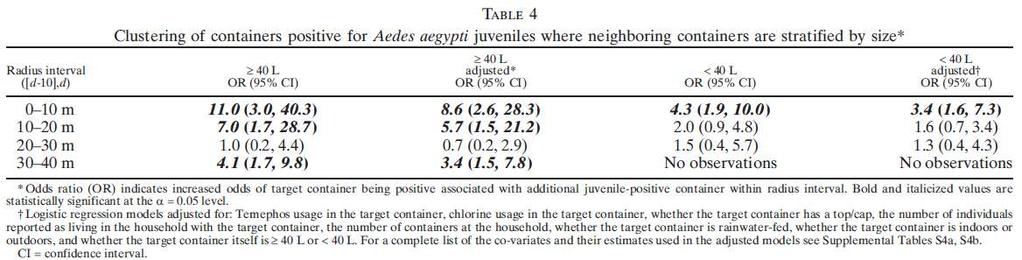
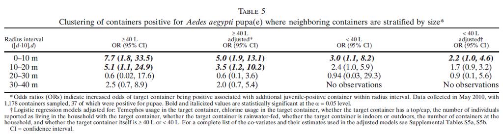
 at 22 sites every 3")


17 Mosquitoes collected (N.J. light traps) at 22 sites every 3 nights, May-September ID to species and counted, pooled by species & sample location Mosquito pools tested for WNV RNA (RT-RTPCR assay) Wild dead birds oral swab tested for WNV (Vec-Test) Sentinel pheasants tested weekly for WNV antibodies (IEA assay)
 varied seasonally and annually Temporal association with 2-wk avg.")
18 Culex pipiens 37,225 mosquitoes sampled Three species dominated: Culex pipiens, Culex restuans, Aedes vexans Mosquito abundance (dotted) varied seasonally and annually Temporal association with 2-wk avg. weather variables Culex restuans
19 Temporal pattern of Corvid bird infection with WNV associated with Culex spp. infection, suggesting role in enzootic transmission

20 Space-time clusters found each year, but in different locations Summary: Analysis of surveillance system data demonstrated spatial and temporal patterns of WNV transmission risk, and role of specific vectors and reservoirs


21 A different problem and much finer spatial scale: Dengue virus transmission household-level risk in Ecuador


 2.")

22 Dengue Basics Mosquito-transmitted flavivirus Human-mosquito-human cycle Four major serotypes (den-1 den-4) 2.5 Billion people live in dengueendemic areas Million cases dengue per year Increasing geographic area, cases, severity


23 Dengue Basics Aedes aegypti mosquitoes primary vector Globally distributed in tropics and sub-tropics Eggs laid in any containers holding water Rapid development in containers Adult mosquitoes: peri-domestic & anthropophagic


24 Households (N=199) randomly selected across geographic extent of Borbon in May 2010 (after rainy season) All water containers in/around each house counted and classified Aedes aegypti mosquito larvae, pupae removed for later identification, counting


25 1,185 containers of various types 58 (~5%) w/ immature mosquitoes 80% uncovered; 61% outdoors; 77% no organic material Larger, uncovered, chlorinated containers more productive
26 Mosquito stage present Larvae, Pupae Adults Larvae, Pupae, Adults None present

27 Target households <10m from immature-positive households had 11 times odds of also being positive Spatial Analysis Proximity to other Positive and Negative households Negative neighbor Positive neighbor 40m 30m Target household Positive neighbor Negative neighbor
28
29 Summary Strong evidence for household-level clustering of Aedes aegypti at <20 m Clustering stronger for large containers (>40 L) Relationships hold after adjusting for container characteristics Patterns likely attributable to short dispersal distances rather than shared characteristics Important implications for human disease risk and mosquito control efforts.

30 Now something different using various metrics and diverse spatial scales: Malaria in Sub-Saharan Africa


31 Characteristics of Malaria Affecting Control and Prevention Parasites Plasmodium protozoa Multiple parasite species, changing antigenicity, Resistance to treatment, no vaccine Vectors Anopheles mosquitoes Multiple species, different ecologies Insecticide resistance increasing Humans Transmission, Infection, Disease Personal protection not simple, SES and KAP factors Asymptomatic infection complicates transmission Changing Geographical Distribution Movement/transport constant problem Rapid long-distance travel, tourism
32 Drivers of Malaria Dynamics Deforestation Environment Civil Strife / War Agriculture/Water Vector Agent Host Rapid Urbanization Drug Resistance Plasmodium spp. Rapid Global Travel Insecticide Resistance Rural Poverty


; all houses geo-located; satellite image of")
33 Study area: highlands NE of Lake Victoria Near Nandi Forest; elev. 1,829 m - 2,132 m Patches of land deforested and planted Large swamp sections drained for agriculture Complete census (pop. ~3,700); all houses geo-located; satellite image of LU/LC Passive surveillance for malaria at local clinic,


34 Houses widely distributed through various habitats and elevations House designated as positive if one case of malaria during year Household-level and proximal environmental variables analyzed using multivariable models Tea and swamp Forest edge
 Clusters consistent across years regardless of incidence Lower altitude, and greater distance to forest and swamp independently increased risk Suggests")
35 Geographic clustering of "hotspots" ( times risk) Clusters consistent across years regardless of incidence Lower altitude, and greater distance to forest and swamp independently increased risk Suggests interventions focused on specific ecological areas are more cost-effective Unknown whether findings are widely generalizable

36 What environmental characteristics might help explain the observed spatial pattern of elevated risk?


37 Malaria data from used to explore microhabitats linked with transmission risk Topographic wetness index generated from digital terrain model of landscape Land-cover/land-use from highresolution satellite image (objectbased classification) Topographic and land-cover variables used to predict household-level malaria (iterative split-sample model fitting)

38 Topographic wetness variables most useful in predicting malaria-positive households Human modified environmental variables (LU/LC) also associated, but did not improve statistical models Topographic wetness values in this highly varied terrain most accurate predictor of risk Control strategies in similar settings may want to use topographic and geographic characteristics to identify high-risk regions for surveillance


39 Drivers of Malaria Dynamics Deforestation Environment Civil Strife / War Agriculture/Water Vector Agent Host Rapid Urbanization Drug Resistance Plasmodium spp. Rapid Global Travel Insecticide Resistance Rural Poverty
 hospitalized patients with a severe anemia, Plasmodium infection; Controls (n = 826) healthy respondents to a concurrent survey")
40 Environmental conditions in urban settings may not be conducive to transmission there Undertook unmatched casecontrol study of risk factors for malarial anemia in urban Kisumu, Kenya Cases (n = 80) hospitalized patients with a severe anemia, Plasmodium infection; Controls (n = 826) healthy respondents to a concurrent survey
41 Multiple environmental and behavioral risk factors identified Use of mosquito coils and bed net, characteristics of housing were NOT significant Children spending >1 night per month in rural area at 9-fold higher risk Implication: exposure during rural travel is important risk of malaria Future studies of urban malaria should consider travel history

42 How might access to prevention help explain the observed spatial patterns of elevated risk?
43
44
45
46


47 What explains observed spatial patterns of elevated risk when mosquito vectors are virtually absent?

48
 of all households with <5 yo children Administered malaria rapid diagnostic test (RDT)")

 Spatial clustering of RDT status and environmental factors analyzed using")
49 Ten villages randomly selected from TA Sitola (N=6) and TA Nsamala (N=4) Census (dry season 2011) of all households with <5 yo children Administered malaria rapid diagnostic test (RDT) to children and questionnaire to parents Households with RDT-positive child designated as "cases"; RDT-negative were "controls" Environmental data: peri-domestic land cover <50 m radius Multivariate logistic regression (MLR) and multi-level multivariate logistic regression (MLLR) Spatial clustering of RDT status and environmental factors analyzed using Getis- Ord Gi*
 Household")


50 Results 390 children enrolled; 45.6% positive for Plasmodium (RDT) Household proximity to agriculture (<25 m radius) highly predictive of positivity (controlled for sex age, bed net ownership, and elevation) Spatial clustering (Gi* z>2.58, p<0.01) of Pearson residuals (MLR), no clustering using MLLR


51 Univariate Gi* Hot Spots Malaria clusters at different scales Malaria cases Village-Level <25m from agriculture TA-Level Bednet ownership Study Area-Level
, and during dry season Important implications for implementing effective surveillance and")
52 Summary Evidence of significant, dry-season spatial heterogeneity of malaria prevalence Pattern strongly linked to peri-domestic land use, particularly nearby crop production Elevated risk seen at very fine geographic scales (tens of meters), and during dry season Important implications for implementing effective surveillance and control
53 Malaria Transmission Cycle - Intervention Points Personal Protection Treatment Longevity Contact Frequency Human Vector Alternative Hosts Biting Rate Vector Human Competence Abundance Proximity to Breeding Sites Parasitemia Prevalence Personal Protection: repellants, bednets, coils, etc. decrease biting success Treatment: reduced duration of parasitemia diminishes acquisition by mosquito Contact Frequency: human abundance, house construction, movement, etc. Alternative Hosts: certain animals reduce number of bites on humans (zooprophylaxis) Competence: certain vector species better able to acquire, develop, transmit Abundance: number of vectors influences average number of bites Proximity to Breeding: closer sites reduce distance needed to find human host Parasitemia Prevalence: more infective people increase population risk Biting Rate: number of partial bloodmeals taken per egg-laying cycle Longevity: infected mosquito must survive parasite development and next bloodmeals
54 Summary Environmental drivers of disease risk involve more than just the biophysical Environmental impacts are spatially-dependent, operating at different spatial scales Spatial analyses of infection transmission provides insights into exposure risks (reservoirs, habitats, treatment and prevention, etc.) Questions being asked should determine the data needed, spatial scale, and analytic methods used Ignoring geographical patterns and spatial dependence is likely to lead to misleading results

55 Knowing is not enough; we must apply. Willing is not enough; we must do. (Goethe)
Urbanization, Land Cover, Weather, and Incidence Rates of Neuroinvasive West Nile Virus Infections In Illinois
 Urbanization, Land Cover, Weather, and Incidence Rates of Neuroinvasive West Nile Virus Infections In Illinois JUNE 23, 2016 H ANNAH MATZ KE Background Uganda 1937 United States -1999 New York Quickly
EPIDEMIOLOGY FOR URBAN MALARIA MAPPING
 TELE-EPIDEMIOLOGY EPIDEMIOLOGY FOR URBAN MALARIA MAPPING @IRD/M Dukhan Vanessa Machault Observatoire Midi-Pyrénées, Laboratoire d Aérologie Pleiades days 17/01/2012 The concept of Tele-epidemiology The
TELE-EPIDEMIOLOGY URBAN MALARIA MAPPING
 TELE-EPIDEMIOLOGY URBAN MALARIA MAPPING Ministère de la Défense Vanessa Machault Advances in Geospatial Technologies for Health 12-13/09/2011 Objective To develop a robust pre-operational methodology to
Predicting Malaria Epidemics in Ethiopia
 Predicting Malaria Epidemics in Ethiopia Eskindir Loha, Hawassa University Torleif Markussen Lunde, UoB 5th Conference on Global Health and Vaccination Research: Environmental Change and Global Health
Cluster Analysis using SaTScan
 Cluster Analysis using SaTScan Summary 1. Statistical methods for spatial epidemiology 2. Cluster Detection What is a cluster? Few issues 3. Spatial and spatio-temporal Scan Statistic Methods Probability
Program Update. Lisle Township August 2018 Status Report SEASON PERSPECTIVE
 Lisle Township August 2018 Status Report SEASON PERSPECTIVE Introduction. Weather conditions critically affect the seasonal mosquito population. Excessive rainfall periods trigger hatches of floodwater
Geographical Information System (GIS)-based maps for monitoring of entomological risk factors affecting transmission of chikungunya in Sri Lanka
-based maps for monitoring of entomological risk factors affecting transmission of chikungunya in Sri Lanka") Geographical Information System (GIS)-based maps for monitoring of entomological risk factors affecting transmission of chikungunya in Sri Lanka M.D. Hapugoda 1, N.K. Gunewardena 1, P.H.D. Kusumawathie
Geographical Information System (GIS)-based maps for monitoring of entomological risk factors affecting transmission of chikungunya in Sri Lanka M.D. Hapugoda 1, N.K. Gunewardena 1, P.H.D. Kusumawathie
The Response of Environmental Capacity for Malaria Transmission in West Africa to Climate Change
 AGU Fall Meeting December 9, 2011 The Response of Environmental Capacity for Malaria Transmission in West Africa to Climate Change Teresa K. Yamana & Elfatih A.B. Eltahir MIT Dept. of Civil & Environmental
Role of GIS in Tracking and Controlling Spread of Disease
 Role of GIS in Tracking and Controlling Spread of Disease For Dr. Baqer Al-Ramadan By Syed Imran Quadri CRP 514: Introduction to GIS Introduction Problem Statement Objectives Methodology of Study Literature
CITY OF FORT COLLINS JULY 2017 MONTHLY REPORT
 CITY OF FORT COLLINS JULY 2017 MONTHLY REPORT AUGUST 3RD, 2017 West Nile Virus Risk Contact VDCI: Northern Colorado Operations Manager Broox Boze, Ph.D. Phone (970)962-2582 Fax (970)962-2584 E-Mail: bboze@
Determine the flooded area based on elevation information and the current water level
 Identifying Data Needs Identifying Data Needs Purpose Before looking for data, the methodology needs to be analyzed to establish what data is needed The most important question that needs to be answered
Towards a risk map of malaria for Sri Lanka
 assessing the options for control of malaria vectors through different water management practices in a natural stream that formed part of such a tank cascade system. The studies established conclusively
Health and Medical Geography (GEOG 222)
") Spring 2019 Class meets: Tuesdays and Thursdays 12:30-1:45pm Carolina Hall Room 220 Instructor: Michael Emch Email: emch@unc.edu Course Objectives Health and Medical Geography (GEOG 222) This course is
Spring 2019 Class meets: Tuesdays and Thursdays 12:30-1:45pm Carolina Hall Room 220 Instructor: Michael Emch Email: emch@unc.edu Course Objectives Health and Medical Geography (GEOG 222) This course is
CITY OF FORT COLLINS JULY 2018 MONTHLY REPORT
 CITY OF FORT COLLINS JULY 2018 MONTHLY REPORT AUGUST 8TH, 2018 West Nile Virus Risk Contact VDCI: Northern Colorado Operations Manager Broox Boze, Ph.D. Phone (970)962-2582 Fax (970)962-2584 As of July
TOTAL RAINFALL June 1 July 24. Mundelein Lake % O Hare Cook % Midway Cook % Romeoville Will
 Village of Hainesville July 2017 - Status Report Season Perspective Weather conditions critically affect the seasonal mosquito population. Excessive rainfall periods trigger hatches of floodwater mosquitoes
Everything is related to everything else, but near things are more related than distant things.
 SPATIAL ANALYSIS DR. TRIS ERYANDO, MA Everything is related to everything else, but near things are more related than distant things. (attributed to Tobler) WHAT IS SPATIAL DATA? 4 main types event data,
EpiMAN-TB, a decision support system using spatial information for the management of tuberculosis in cattle and deer in New Zealand
 EpiMAN-TB, a decision support system using spatial information for the management of tuberculosis in cattle and deer in New Zealand J.S. McKenzie 1, R.S. Morris 1, C.J. Tutty 2, D.U. Pfeiffer 1 Dept of
MULTIPLE CHOICE. Choose the one alternative that best completes the statement or answers the question.
 Exam Name MULTIPLE CHOICE. Choose the one alternative that best completes the statement or answers the question. 1) One important feature of the world's population with the most significant future implications
CITY OF FORT COLLINS AUGUST 2016 MONTHLY REPORT
 CITY OF FORT COLLINS AUGUST 2016 MONTHLY REPORT MONTHLY REPORT: SEPTEMBER 6, 2016 COLORADO MOSQUITO CONTROL West Nile Virus Risk Contact CMC: City of Fort Collins Mosquito Control Program Broox Boze, Operations
IUCN Red List Process. Cormack Gates Keith Aune
 IUCN Red List Process Cormack Gates Keith Aune The IUCN Red List Categories and Criteria have several specific aims to provide a system that can be applied consistently by different people; to improve
Understanding the role of land cover / land use nexus in malaria transmission under changing socio-economic climate in Myanmar
 Annual Report for Year 1 June, 2017 January, 2018 NASA Land Cover Land Use Change Program Funded under grant # NNX17AI06G: Understanding the role of land cover / land use nexus in malaria transmission
Mapping Malaria Risk in Dakar, Senegal. Marion Borderon, Sébastien Oliveau
 Mapping Malaria Risk in Dakar, Senegal Marion Borderon, Sébastien Oliveau When entomology meets social sciences Framework of the research - ANR ACTU PALU - interdisciplinary project Data & method Social
This report details analyses and methodologies used to examine and visualize the spatial and nonspatial
 Analysis Summary: Acute Myocardial Infarction and Social Determinants of Health Acute Myocardial Infarction Study Summary March 2014 Project Summary :: Purpose This report details analyses and methodologies
Vector Hazard Report: Malaria in Ghana Part 1: Climate, Demographics and Disease Risk Maps
 Vector Hazard Report: Malaria in Ghana Part 1: Climate, Demographics and Disease Risk Maps Information gathered from products of The Walter Reed Biosystematics Unit (WRBU) VectorMap Systematic Catalogue
Understanding landscape metrics. The link between pattern and process.
 Understanding landscape metrics The link between pattern and process. Roadmap Introduction Methodological considerations Spatial autocorrelation Stationarity Processes Abiotic Biotic Anthropogenic Disturbances
CLIMATE AND LAND USE DRIVERS OF MALARIA RISK IN THE PERUVIAN AMAZON,
 CLIMATE AND LAND USE DRIVERS OF MALARIA RISK IN THE PERUVIAN AMAZON, 2001-2012 Ben Zaitchik Johns Hopkins University Beth Feingold, Denis Valle, Alex Sandoval, Carlos Alvarez Antonio, Rosa Patricia Zegarra
The Current SLE/WN Epidemic Assesment
 FMEL Arboviral Epidemic Risk Assessment: First Update for 2014 Week 18 (May 1, 2014) The Current SLE/WN Epidemic Assesment Funding for the Florida Medical Entomology Laboratory Epidemic Risk Model ended
Peninsular Florida p Modeled Water Table Depth Arboviral Epidemic Risk Assessment. Current Assessment: 06/08/2008 Week 23 Initial Wetting Phase
 Peninsular Florida p Modeled Water Table Depth Arboviral Epidemic Risk Assessment Current Assessment: 06/08/2008 Week 23 Initial Wetting Phase Modeled Water Table Depth: MWTD has remained low across much
Population Ecology. Chapter 44
 Population Ecology Chapter 44 Stages of Biology O Ecology is the interactions of organisms with other organisms and with their environments O These interactions occur in different hierarchies O The simplest
Geography Policy 2014
 Geography Policy 2014 DEFINITION Geography education should inspire in pupils a curiosity and fascination about the world and its people that will remain with them for the rest of their lives. Teaching
Section 8. North American Biomes. What Do You See? Think About It. Investigate. Learning Outcomes
 Section 8 North American Biomes What Do You See? Learning Outcomes In this section, you will Define the major biomes of North America and identify your community s biome. Understand that organisms on land
Switching to AQA from Edexcel: Draft Geography AS and A-level (teaching from September 2016)
") Switching to AQA from Edexcel: Draft Geography AS and A-level (teaching from September 2016) If you are thinking of switching from OCR to AQA (from September 2016), this resource is an easy reference guide.
Switching to AQA from Edexcel: Draft Geography AS and A-level (teaching from September 2016) If you are thinking of switching from OCR to AQA (from September 2016), this resource is an easy reference guide.
La santé dans les villes : de l approche géographique aux collaborations entre chercheurs et décideurs
 La santé dans les villes : de l approche géographique aux collaborations entre chercheurs et décideurs Pr. Gérard Salem, Université Paris-Nanterre, ISUH-ICSu Séminaire Maladies Infectieuses Emergentes
CHAPTER. Population Ecology
 CHAPTER 4 Population Ecology Chapter 4 TOPIC POPULATION ECOLOGY Indicator Species Serve as Biological Smoke Alarms Indicator species Provide early warning of damage to a community Can monitor environmental
School of Geography and Geosciences. Head of School Degree Programmes. Programme Requirements. Modules. Geography and Geosciences 5000 Level Modules
 School of Geography and Geosciences Head of School Degree Programmes Graduate Diploma: Dr W E Stephens Health Geography Research Environmental History and Policy (see School of History) M.Res.: M.Litt.:
Land Use/Cover Changes & Modeling Urban Expansion of Nairobi City
 Land Use/Cover Changes & Modeling Urban Expansion of Nairobi City Overview Introduction Objectives Land use/cover changes Modeling with Cellular Automata Conclusions Introduction Urban land use/cover types
Pathways. Pathways through the Geography Major
 Pathways through the Major majors may structure their course selections around a sub-field of. Pathways are suggestions for classes in, in related disciplines, and skills training. Each pathway includes
Ecology Notes CHANGING POPULATIONS
 Ecology Notes TEK 8.11 (B) Investigate how organisms and populations in an ecosystem depend on and may compete for biotic and abiotic factors such as quantity of light, water, range of temperatures, or
Population Ecology. Study of populations in relation to the environment. Increase population size= endangered species
 Population Basics Population Ecology Study of populations in relation to the environment Purpose: Increase population size= endangered species Decrease population size = pests, invasive species Maintain
Core Courses for Students Who Enrolled Prior to Fall 2018
 Biostatistics and Applied Data Analysis Students must take one of the following two sequences: Sequence 1 Biostatistics and Data Analysis I (PHP 2507) This course, the first in a year long, two-course
INTRODUCTION. In March 1998, the tender for project CT.98.EP.04 was awarded to the Department of Medicines Management, Keele University, UK.
 INTRODUCTION In many areas of Europe patterns of drug use are changing. The mechanisms of diffusion are diverse: introduction of new practices by new users, tourism and migration, cross-border contact,
Sampling approaches in animal health studies. Al Ain November 2017
 Sampling approaches in animal health studies Al Ain 13-14 November 2017 Definitions Populations and Samples From a statistical point of view: Population is a set of measurements, that may be finite or
ESRI 2008 Health GIS Conference
 ESRI 2008 Health GIS Conference An Exploration of Geographically Weighted Regression on Spatial Non- Stationarity and Principal Component Extraction of Determinative Information from Robust Datasets A
WHAT IS BIOLOGICAL DIVERSITY?
 WHAT IS BIOLOGICAL DIVERSITY? Biological diversity or biodiversity is the variety of life - the wealth of life forms found on earth. 9 WHAT IS BIOLOGICAL DIVERSITY? Wilcox s (1984) definition: Biological
Population Ecology and the Distribution of Organisms. Essential Knowledge Objectives 2.D.1 (a-c), 4.A.5 (c), 4.A.6 (e)
, 4.A.5 (c), 4.A.6 (e)") Population Ecology and the Distribution of Organisms Essential Knowledge Objectives 2.D.1 (a-c), 4.A.5 (c), 4.A.6 (e) Ecology The scientific study of the interactions between organisms and the environment
Population Ecology and the Distribution of Organisms Essential Knowledge Objectives 2.D.1 (a-c), 4.A.5 (c), 4.A.6 (e) Ecology The scientific study of the interactions between organisms and the environment
ANIMAL ECOLOGY (A ECL)
") Animal Ecology (A ECL) 1 ANIMAL ECOLOGY (A ECL) Courses primarily for undergraduates: A ECL 312: Ecology (Cross-listed with BIOL, ENSCI). (3-3) Cr. 4. SS. Prereq: BIOL 211, BIOL 211L, BIOL 212, and BIOL
Animal Ecology (A ECL) 1 ANIMAL ECOLOGY (A ECL) Courses primarily for undergraduates: A ECL 312: Ecology (Cross-listed with BIOL, ENSCI). (3-3) Cr. 4. SS. Prereq: BIOL 211, BIOL 211L, BIOL 212, and BIOL
Climate Variability and Malaria over the Sahel Country of Senegal
 Climate Variability and Malaria over the Sahel Country of Senegal Ibrahima DIOUF CPC International Desks NOAA Center for Weather and Climate Prediction 5830 University Research Court, College Park, Maryland
GIS and Health Geography. What is epidemiology?
 GIS and Health Geography { What is epidemiology? TOC GIS and health geography Major applications for GIS Epidemiology What is health (and how location matters) What is a disease (and how to identify one)
Manitoba Weekly West Nile virus Surveillance Report
 Manitoba Weekly West Nile virus Surveillance Report Week 26 (June 25 to July 1, 2017) Communicable Disease Control Active Living, Population and Public Health Branch Active Living, Indigenous Relations,
Applications of GIS in Health Research. West Nile virus
 Applications of GIS in Health Research West Nile virus Outline Part 1. Applications of GIS in Health research or spatial epidemiology Disease Mapping Cluster Detection Spatial Exposure Assessment Assessment
Rethinking Urbanization in the 21 st Century
 Rethinking Urbanization in the 21 st Century Karen C. Seto Professor of Geography & Urbanization Science School of Forestry & Environmental Studies Yale University SESYNC April 13, 2016 From now until
Geography General Course Year 12. Selected Unit 3 syllabus content for the. Externally set task 2019
 Geography General Course Year 12 Selected Unit 3 syllabus content for the Externally set task 2019 This document is an extract from the Geography General Course Year 12 syllabus, featuring all of the content
Topic 4: Changing cities
 Topic 4: Changing cities Overview of urban patterns and processes 4.1 Urbanisation is a global process a. Contrasting trends in urbanisation over the last 50 years in different parts of the world (developed,
Geography - Grade 8. Unit A - Global Settlement: Patterns and Sustainability
 Geography - Grade 8 Geographical Thinking: Spatial Significance Patterns and Trends Interrelationships Geographic Perspective Geographic Inquiry: STEP 1 - Formulate Questions STEP 2 - Gather and Organize
Agro Ecological Malaria Linkages in Uganda, A Spatial Probit Model:
 Agro Ecological Malaria Linkages in Uganda, A Spatial Probit Model: IFPRI Project Title: Environmental management options and delivery mechanisms to reduce malaria transmission in Uganda Spatial Probit
Using GIS: to analyze vector borne disease. David Attaway Esri
 Using GIS: to analyze vector borne disease David Attaway Esri Why do I care? Example: YELP Most of us have used it Most of us let it help guide our decisions Most see it helpful But. How does this relate
An Introduction to SaTScan
 An Introduction to SaTScan Software to measure spatial, temporal or space-time clusters using a spatial scan approach Marilyn O Hara University of Illinois moruiz@illinois.edu Lecture for the Pre-conference
Impacts of Climate Change on Public Health: Bangladesh Perspective
 Global Journal of Environmental Research 5 (3): 97-15, 211 ISSN 199-925X IDOSI Publications, 211 Impacts of Climate Change on Public Health: Bangladesh Perspective M. Ruhul Amin, S.M. Tareq and S.H. Rahman
AP HUG REVIEW WELCOME TO 2 ND SEMESTER! Annette Parkhurst, M.Ed. January, 2015
 AP HUG REVIEW WELCOME TO 2 ND SEMESTER! Annette Parkhurst, M.Ed. January, 2015 Movement Globalization Latitude & Elevation Levels of Economic Activities CONNECTIONS Human Geography Human is the geography
Range of Opportunities
 Geograhy Curriculum Cropwell Bishop Primary School Range of Opportunities Year 1 Year 2 Year 3 Year 4 Year 5 Year 6 All Key Stage 1 Key Stage 2 Investigate the countries and capitals of the United Kingdom.
GEOGRAPHY (GEOGRPHY) Geography (GEOGRPHY) 1
 Geography (GEOGRPHY) 1") Geography (GEOGRPHY) 1 GEOGRAPHY (GEOGRPHY) GEOGRPHY 1040 Planet Earth 4 Credits The features of the natural environment (lithosphere, atmosphere and hydrosphere); their character, distribution, origin
Geography (GEOGRPHY) 1 GEOGRAPHY (GEOGRPHY) GEOGRPHY 1040 Planet Earth 4 Credits The features of the natural environment (lithosphere, atmosphere and hydrosphere); their character, distribution, origin
Modeling Risk of Japanese
 Modeling Risk of Japanese Encephalitis i in Korea Penny Masuoka, Terry A. Klein, Heung C. Kim, David Claborn, Nicole Achee, Richard Andre, Judith Chamberlin, Kevin Taylor, Susan George, Jennifer Small,
11/10/13. How do populations and communities interact and change? Populations. What do you think? Do you agree or disagree? Do you agree or disagree?
 Chapter Introduction Lesson 1 Populations Lesson 2 Changing Populations Lesson 3 Communities Chapter Wrap-Up How do populations and communities interact and change? What do you think? Before you begin,
Geographical knowledge and understanding scope and sequence: Foundation to Year 10
 Geographical knowledge and understanding scope and sequence: Foundation to Year 10 Foundation Year 1 Year 2 Year 3 Year 4 Year 5 Year 6 Year level focus People live in places Places have distinctive features
Seymour Centre 2017 Education Program 2071 CURRICULUM LINKS
 Suitable for: Stage 5 Stage 6 HSC Subject Links: Seymour Centre 2017 Education Program 2071 CURRICULUM LINKS Science Stage Content Objective Outcomes Stage 5 Earth and Space ES3: People use scientific
Chitra Sood, R.M. Bhagat and Vaibhav Kalia Centre for Geo-informatics Research and Training, CSK HPKV, Palampur , HP, India
 APPLICATION OF SPACE TECHNOLOGY AND GIS FOR INVENTORYING, MONITORING & CONSERVATION OF MOUNTAIN BIODIVERSITY WITH SPECIAL REFERENCE TO MEDICINAL PLANTS Chitra Sood, R.M. Bhagat and Vaibhav Kalia Centre
Spatio-temporal modeling of weekly malaria incidence in children under 5 for early epidemic detection in Mozambique
 Spatio-temporal modeling of weekly malaria incidence in children under 5 for early epidemic detection in Mozambique Katie Colborn, PhD Department of Biostatistics and Informatics University of Colorado
Section III: Poverty Mapping Results
 Section III: Poverty Mapping Results Figure 5: Gewog level rural poverty map 58. The most prominent result from the poverty mapping exercise of Bhutan is the production of a disaggregated poverty headcount
CBA Practice Exam - Ecology
 CBA Practice Exam - Ecology For the following two questions, use the diagram below: 1. (TEKS 11B) The organisms in the illustration are all part of a pond community. What would likely happen to the fish
National Disaster Management Centre (NDMC) Republic of Maldives. Location
 Republic of Maldives. Location") National Disaster Management Centre (NDMC) Republic of Maldives Location Country Profile 1,190 islands. 198 Inhabited Islands. Total land area 300 sq km Islands range b/w 0.2 5 sq km Population approx.
National Disaster Management Centre (NDMC) Republic of Maldives Location Country Profile 1,190 islands. 198 Inhabited Islands. Total land area 300 sq km Islands range b/w 0.2 5 sq km Population approx.
FMEL Arboviral Epidemic Risk Assessment: Second Update for 2012 Week 23 (June 12, 2012)
") FMEL Arboviral Epidemic Risk Assessment: Second Update for 2012 Week 23 (June 12, 2012) Current Assesment of SLW\WN Epidemic Risk Figure 1. A map of peninsular Florida indicating areas currently at Medium
FMEL Arboviral Epidemic Risk Assessment: Second Update for 2012 Week 23 (June 12, 2012) Current Assesment of SLW\WN Epidemic Risk Figure 1. A map of peninsular Florida indicating areas currently at Medium
Definitions Weather and Climate Climates of NYS Weather Climate 2012 Characteristics of Climate Regions of NYS NYS s Climates 1.
 Definitions Climates of NYS Prof. Anthony Grande 2012 Weather and Climate Weather the state of the atmosphere at one point in time. The elements of weather are temperature, t air pressure, wind and moisture.
The Cultural Landscape: An Introduction to Human Geography, 10e (Rubenstein) Chapter 2 Population
 Chapter 2 Population") The Cultural Landscape: An Introduction to Human Geography, 10e (Rubenstein) Chapter 2 Population 1) One important feature of the world's population with the most significant future implications is that
The Cultural Landscape: An Introduction to Human Geography, 10e (Rubenstein) Chapter 2 Population 1) One important feature of the world's population with the most significant future implications is that
Advanced Placement Human Geography
 Advanced Placement Human Geography I. Overview of the Course The purpose of the Advanced Placement (AP) Human Geography course is to introduce students to the systematic study of patterns and processes
Department of Geography: Vivekananda College for Women. Barisha, Kolkata-8. Syllabus of Post graduate Course in Geography
 India: Regional Problems and Resource management Module 11 (Full Marks 50) Unit I: Region and Regionalisation 1.1 Various bases of regionalisation of India; problems of identification and delineation.
Identification of hotspots of rat abundance and their effect on human risk of leptospirosis in a Brazilian slum community
 Identification of hotspots of rat abundance and their effect on human risk of leptospirosis in a Brazilian slum community Poppy Miller 1 Kate Hacker 2 Peter Diggle 1 Mike Begon 3 James Childs 2 Albert
Exam I. Principles of Ecology. September 19, Name. Multiple guess. Circle the letter of the best answer. [4 points each, 40 pts total]
![Exam I. Principles of Ecology. September 19, Name. Multiple guess. Circle the letter of the best answer. [4 points each, 40 pts total]](/thumbs/86/93077368.jpg "Exam I. Principles of Ecology. September 19, Name. Multiple guess. Circle the letter of the best answer. [4 points each, 40 pts total]") Exam I. Principles of Ecology. September 19, 2008. Name Multiple guess. Circle the letter of the best answer. [4 points each, 40 pts total] 1. The two hosts most responsible for the spread of West Nile
Exam I. Principles of Ecology. September 19, 2008. Name Multiple guess. Circle the letter of the best answer. [4 points each, 40 pts total] 1. The two hosts most responsible for the spread of West Nile
A Framework for the Study of Urban Health. Abdullah Baqui, DrPH, MPH, MBBS Johns Hopkins University
 This work is licensed under a Creative Commons Attribution-NonCommercial-ShareAlike License. Your use of this material constitutes acceptance of that license and the conditions of use of materials on this
THE EFFECT OF GEOGRAPHY ON SEXUALLY TRANSMITTED
 THE EFFECT OF GEOGRAPHY ON SEXUALLY TRANSMITTED INFECTIONS Tommi L. Gaines, Dr.P.H. University of California, San Diego Division of Global Public Health Geospatial Frontiers in Health and Social Environments
Tuition, Medical and Behaviour Support Service
 Tuition, Medical and Behaviour Support Service Curriculum Policy - Primary Geography Reviewed: October 2018 Next Review: October 2019 Responsibility: Andrea Snow AIMS AND PRINCIPLES The national curriculum
Introduction to risk assessment
 Introduction to risk assessment Inception workshop of the project Strengthening the regional preparedness, prevention and response against lumpy skin disease in Belarus, Moldova and Ukraine (TCP/RER/3605)
Chapter 2 Section 1 discussed the effect of the environment on the phenotype of individuals light, population ratio, type of soil, temperature )
") Chapter 2 Section 1 discussed the effect of the environment on the phenotype of individuals light, population ratio, type of soil, temperature ) Chapter 2 Section 2: how traits are passed from the parents
Chapter 2 Section 1 discussed the effect of the environment on the phenotype of individuals light, population ratio, type of soil, temperature ) Chapter 2 Section 2: how traits are passed from the parents
1. INTRODUCTION REGIONAL ACTIVITIES
 P 1.11 DEVELOPMENT OF CLIMATE INDICES FOR MONITORING VECTORS OF WEST NILE VIRUS Michael J. Janis Southeast Regional Climate Center, Columbia, SC Kenneth E. Kunkel Illinois State Water Survey, Champaign,
Globally Estimating the Population Characteristics of Small Geographic Areas. Tom Fitzwater
 Globally Estimating the Population Characteristics of Small Geographic Areas Tom Fitzwater U.S. Census Bureau Population Division What we know 2 Where do people live? Difficult to measure and quantify.
MULTI-SCALE MODELING OF MALARIA: FROM ENDEMICITY TO ELIMINATION
 MULTI-SCALE MODELING OF MALARIA: FROM ENDEMICITY TO ELIMINATION or the DEATH of SEIR models Juan B. Gutierrez UGA s Department of Mathematics & Institute of Bioinformatics December 14, 2012 1 / 19 Collaborators
Metacommunities Spatial Ecology of Communities
 Spatial Ecology of Communities Four perspectives for multiple species Patch dynamics principles of metapopulation models (patchy pops, Levins) Mass effects principles of source-sink and rescue effects
Introduction to GIS. Dr. M.S. Ganesh Prasad
 Introduction to GIS Dr. M.S. Ganesh Prasad Department of Civil Engineering The National Institute of Engineering, MYSORE ganeshprasad.nie@gmail.com 9449153758 Geographic Information System (GIS) Information
ST AMBROSE CATHOLIC PRIMARY SCHOOL Geography Policy
 ST AMBROSE CATHOLIC PRIMARY SCHOOL Geography Policy 2017-2018 Our school policy is developed in accordance with the National Curriculum for Geography and Foundation Stage Curriculum for Understanding of
GIS, SPATIAL INTERPOLATION AND MODELS FOR DECISION MAKING IN AGRICULTURE
 GIS, SPATIAL INTERPOLATION AND MODELS FOR DECISION MAKING IN AGRICULTURE Anna Dalla Marta, Simone Orlandini Department of Agronomy and Land Management University of Florence Nowadays, the existing relationships
Landscape Epidemiology Modeling Using an Agent-Based Model and a Geographic Information System
 Land 2015, 4, 37-412; doi:10.3390/land402037 OPEN ACCESS land ISSN 2073-445X www.mdpi.com/journal/land Article Landscape Epidemiology Modeling Using an Agent-Based Model and a Geographic Information System
School of Environmental Sciences, Bharathidasan University, Tiruchirappalli Centre for Research in Medical Entomology, Madurai
 Development Vector Surveillance System through Bio-spatial Technology for Better Public Health Services A case study M. Govindaraju 1, P. Suganthi 1, V.Thenmozhi 2 and B.K. Tyagi 2 1 Bio - Spatial Technology
Curriculum Unit. Instructional Unit #1
 Curriculum Unit Name of Course: AP Human Geography Grade Level(s): 9-12 Brief Description (Course Catalog): The purpose of the AP Human Geography course is to introduce students to the systematic study
Using Geospatial Methods with Other Health and Environmental Data to Identify Populations
 Using Geospatial Methods with Other Health and Environmental Data to Identify Populations Ellen K. Cromley, PhD Consultant, Health Geographer ellen.cromley@gmail.com Purpose and Outline To illustrate the
Site-specific Prediction of Mosquito Abundance using Spatio-Temporal Geostatistics
 Site-specific Prediction of Mosquito Abundance using Spatio-Temporal Geostatistics E.-H. Yoo 1, D. Chen 2 and C. Russell 3 1 Department of Geography, University at Buffalo, SUNY, Buffalo, NY, USA eunhye@buffalo.edu,
Curriculum map GEOGRAPHY
 Curriculum map Learning outcomes (LOs): Having completed a major in Geography, a student will be able to: 1. Demonstrate an understanding of the major biophysical and social patterns in the world, and
Pee Dee Explorer. Science Standards
 Science Standards About Pee Dee Explorer What does it mean when someone says they are from the "Pee Dee" of South Carolina? A place is bigger than its physical geography. A "sense of place" weaves together
Climate Change and Biomes
 Climate Change and Biomes Key Concepts: Greenhouse Gas WHAT YOU WILL LEARN Biome Climate zone Greenhouse gases 1. You will learn the difference between weather and climate. 2. You will analyze how climate
Introduction. Ecology is the scientific study of the interactions between organisms and their environment.
 Introduction Ecology is the scientific study of the interactions between organisms and their environment. 1. The interactions between organisms and their environments determine the distribution and abundance
This table connects the content provided by Education Perfect to the NSW Syllabus.
 Education Perfect Geography provides teachers with a wide range of quality, engaging and innovative content to drive positive student learning outcomes. Designed by teachers and written by our in-house
1 Disease Spread Model
 Technical Appendix for The Impact of Mass Gatherings and Holiday Traveling on the Course of an Influenza Pandemic: A Computational Model Pengyi Shi, Pinar Keskinocak, Julie L Swann, Bruce Y Lee December