Big Data and Geospatial with HPCC Systems
|
|
|
- Bruno Warner
- 5 years ago
- Views:
Transcription


1 Big Data and Geospatial with HPCC Systems Powered by LexisNexis Risk Solutions Ignacio Calvo Greg McRandal 10/05/2016
2 Concepts in Geospatial How to use them with HPCC Use

3 Definition An approach to applying statistical analysis and other analytic techniques to data which has a geographical or spatial aspect
4

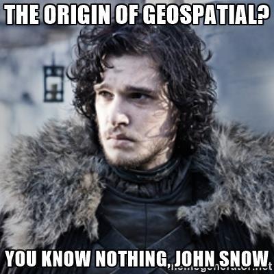
5 Origin of Geospatial John Snow s original map (1854), using GIS to save lives. This map was used to determine that Cholera was water-borne


6 Understanding the data Need to know : Format Projection / coordinate system

7 Formats : Vector vs Raster Vector Raster

8 What is a projection? Projections are used to represent the world in ways we can process The Earth is round and maps are flat Physical Maps Computer Maps Have I seen projections before? Peter vs Mercator vs Winkel tripel GPS (latitude/longitude) Google Maps

9 Projections Two different projections representing the same place.

10 Projections to know about WGS84 Latitude and longitude Our best approximation of the world Not always the best for a specific region Not technically a projection Mercator Many different ones, choose one based on your location Reduces the area it covers to a simple Cartesian plane Good near the central axis, bad far away from it : Web Mercator covers the whole world good near equator, gets worse as you travel north or south Irish National Grid very good for Ireland, awful anywhere else.


11 Lies, damned lies, statistics and maps! *

12 Lies, damned lies, statistics and maps! Projection Woes: A straight line in Mercator is not a straight line in WGS84 Don t re-project polygons! Four points converted to WGS84 This solution is only good enough for visuals, not for maths. Where the lines should be


13 Lies, damned lies, statistics and maps!


14 Lies, damned lies, statistics and maps! Visuals don t agree with maths: Wind and Hail. Web Mercator WGS84

15 Number one bug in Geospatial *
16 Number one bug in Geospatial Latitude Longitude X Y LatY LonX


17 Now I understand my data, what s next? Data Ingest Index Query

18 Bringing Geospatial into HPCC GOAL Bring our geospatial processes into the realm of Big Data
19 Big Data STEPS Extend HPCC and ECL to support the following main capabilities : Spatial filtering of vector geometries Spatial operations using vector geometries Spatial reference projection and transformation Reading of compressed geo-raster files


20 Big Data STEPS Integration of open source libraries
21 Ingesting Vector Data 1. Policy data 2. Geocode address 3. Peril tag Data ready to ingest It s a CSV file. Id Name Geometry Projection Value 1 Alice s place POINT ( ) 4326* 5,973,000 2 Bob s place POINT ( ) ,000 3 Celine s place POINT ( ) ,324,000 * WGS84 (Lat/Lon)

22 Ingesting Vector Data 1. Shape data 2. Parse XPATH 3. Process and index Data ready to query It s a GML / XML file.
23 Ingesting Vector Data 1. Shape data 2. Parse XPATH 3. Process and index Data ready to query It s a GML / XML file.

24 Ingesting Vector Data 1. Shape data 2. Parse XPATH 3. Process and index Data ready to query It s a GML / XML file.


25 Indexing vector data Outline Box: Biggest rectangle Boxes contain boxes Bottom box in the tree contains actual geometries Here, 3 levels pictured Boxes can overlap (entries are only in one)
26 Querying vector data Searching an R-Tree: e.g. Finding all buildings (points) inside a flood zone (polygon) N Does the query polygon overlap our box? Y Return empty list Is it a leaf node? Y Return all nodes for verification N Search our boxes children

27 Ingesting Raster Data 1. Raster data 2. Tile and spray 3. Process and index Data ready to query It s a raster / TIFF file. Bitmap image

28 Ingesting Raster Data 1. Raster data 2. Tile and spray 3. Process and index Data ready to query Tiling divides raster images into small manageable areas of known dimensions. These tiles have their own metadata: Bounding box Grid position

29 Ingesting Raster Data 1. Raster data 2. Tile and spray 3. Process and index Data ready to query 1. Figure out which grid position the geometry needs 2. Extract the required pixel 3. Interrogate the pixel for its value 4. Interpret its value 5. Return to user


30 Ingesting Raster Data 1. Raster data 2. Tile and spray 3. Process and index Data ready to query It s a raster / TIFF file. Bitmap image

31 Ingesting Raster Data 1. Raster data 2. Tile and spray 3. Process and index Data ready to query It s a raster / TIFF file.

32 Bringing it all together *Andrew Farrell In pursuit of perils : Geo-spatial risk analysis through HPCC Systems

33 Add even more value

34 Add even more value

35 Why Geospatial with HPCC? Efficient parallel processing Ability to import libraries from different languages Good coverage of functions and spatial predicates Fast ingestion Support for different formats Sub-second queries

36

37 hpccsystems.com
Geographic Information Systems. Introduction to Data and Data Sources
 Geographic Information Systems Introduction to Data and Data Sources Presented by John Showler, NJDA-SSCC NJ SCD GIS Training Session December 10, 209 The Objectives of this session are 3-fold: 1. Introduce
Intro to GIS In Review
 Intro to GIS In Review GIS Analysis Winter 2016 GIS A quarter in review Geographic data types Acquiring GIS data Projections / Coordinate systems Working with attribute tables Data classification Map design
Illustrator: Vector base Each line/point store some sort of information Mapping Representation of the world
 Illustrator: Vector base Each line/point store some sort of information Mapping Representation of the world Photoshop Raster base Images can be overlaid Pixel vector data model: [data models] A representation
Introduction to GIS Sarah Watson University of Kentucky Libraries March 6, 2017
 Introduction to GIS Sarah Watson sarahwatson@uky.edu University of Kentucky Libraries March 6, 2017 Outline Overview of various terms Quick overview of ArcGIS and QGIS Geocoding Activity Considering Map
DATA SCIENCE SIMPLIFIED USING ARCGIS API FOR PYTHON
 DATA SCIENCE SIMPLIFIED USING ARCGIS API FOR PYTHON LEAD CONSULTANT, INFOSYS LIMITED SEZ Survey No. 41 (pt) 50 (pt), Singapore Township PO, Ghatkesar Mandal, Hyderabad, Telengana 500088 Word Limit of the
ISO MODIS NDVI Weekly Composites for Canada South of 60 N Data Product Specification
 ISO 19131 MODIS NDVI Weekly Composites for South of 60 N Data Product Specification Revision: A Data specification: MODIS NDVI Composites for South of 60 N - Table of Contents - 1. OVERVIEW... 3 1.1. Informal
How a Media Organization Tackles the. Challenge Opportunity. Digital Gazetteer Workshop December 8, 2006
 A Case-Study-In-Process: How a Media Organization Tackles the Georeferencing Challenge Opportunity Digital Gazetteer Workshop December 8, 2006 to increase and diffuse geographic knowledge 1888 to 2006:
All About Spatial Data. Find it, Manage it, Use it
 All About Spatial Data Find it, Manage it, Use it Workshop Outline Define spatial data Spatial data formats Data Sources Metadata Evaluating Spatial Data Data Management Activities: define spatial data,
DATA 301 Introduction to Data Analytics Geographic Information Systems
 DATA 301 Introduction to Data Analytics Geographic Information Systems Dr. Ramon Lawrence University of British Columbia Okanagan ramon.lawrence@ubc.ca DATA 301: Data Analytics (2) Why learn Geographic
ArcGIS for Applied Economists Session 2
 ArcGIS for Applied Economists Session 2 Mark Westcott LMU Munich June 15, 2015 1 / 31 Topics for this session: Geographic Coordinate Systems Projections Projected Coordinate Systems Geocoding 2 / 31 Some
Data Structures & Database Queries in GIS
 Data Structures & Database Queries in GIS Objective In this lab we will show you how to use ArcGIS for analysis of digital elevation models (DEM s), in relationship to Rocky Mountain bighorn sheep (Ovis
These modules are covered with a brief information and practical in ArcGIS Software and open source software also like QGIS, ILWIS.
 Online GIS Training and training modules covered are: 1. ArcGIS, Analysis, Fundamentals and Implementation 2. ArcGIS Web Data Sharing 3. ArcGIS for Desktop 4. ArcGIS for Server These modules are covered
10/13/2011. Introduction. Introduction to GPS and GIS Workshop. Schedule. What We Will Cover
 Introduction Introduction to GPS and GIS Workshop Institute for Social and Environmental Research Nepal October 13 October 15, 2011 Alex Zvoleff azvoleff@mail.sdsu.edu http://rohan.sdsu.edu/~zvoleff Instructor:
Gridded Ambient Air Pollutant Concentrations for Southern California, User Notes authored by Beau MacDonald, 11/28/2017
 Gridded Ambient Air Pollutant Concentrations for Southern California, 1995-2014 User Notes authored by Beau, 11/28/2017 METADATA: Each raster file contains data for one pollutant (NO2, O3, PM2.5, and PM10)
Geographical Information Systems
 Geographical Information Systems Geographical Information Systems (GIS) is a relatively new technology that is now prominent in the ecological sciences. This tool allows users to map geographic features
SPOT DEM Product Description
 SPOT DEM Product Description Version 1.1 - May 1 st, 2004 This edition supersedes previous versions Acronyms DIMAP DTED DXF HRS JPEG, JPG DEM SRTM SVG Tiff - GeoTiff XML Digital Image MAP encapsulation
A Geographer s role in a Google Maps World. Jeremy Bartley ESRI
 A Geographer s role in a Google Maps World Jeremy Bartley ESRI 1 It is a good time to be a Geographer. 2 Microsoft, Google, Yahoo, and others are pushing geographic awareness to the general public Providing
Geospatial Products V8i (SELECTseries 1)
") Geospatial Products V8i (SELECTseries 1) Keith Raymond Product Manager Geospatial Desktop Products Presentation Overview What are the various products? Why would you need them? Demonstrations 2 WWW.BENTLEY.COM
Geospatial Products V8i (SELECTseries 1) Keith Raymond Product Manager Geospatial Desktop Products Presentation Overview What are the various products? Why would you need them? Demonstrations 2 WWW.BENTLEY.COM
Understanding Projections for GIS
 Presented by John Schaeffer Juniper GIS Services, Inc. This PowerPoint is available at JuniperGIS.com Presentation Objectives To understand basic concepts on projections and coordinate systems for the
GIS Data Structure: Raster vs. Vector RS & GIS XXIII
 Subject Paper No and Title Module No and Title Module Tag Geology Remote Sensing and GIS GIS Data Structure: Raster vs. Vector RS & GIS XXIII Principal Investigator Co-Principal Investigator Co-Principal
5A.10 A GEOSPATIAL DATABASE AND CLIMATOLOGY OF SEVERE WEATHER DATA
 5A.10 A GEOSPATIAL DATABASE AND CLIMATOLOGY OF SEVERE WEATHER DATA Steve Ansari * and Stephen Del Greco NOAA National Climatic Data Center, Asheville, North Carolina Mark Phillips University of North Carolina
Catchment Delineation Workflow
 Catchment Delineation Workflow Slide 1 Given is a GPS point (Lat./Long.) for an outlet location. The outlet could be a proposed Dam site, a storm water drainage culvert on a rural highway, or any other
ISO Daily 10 km Gridded Climate Dataset for Canada ( ) Data Product Specifications. Revision: A
 Data Product Specifications. Revision: A") ISO 19131 Daily 10 km Gridded Climate Dataset for Canada (1950-2012) Data Product Specifications Revision: A Data product specifications: Daily 10 km Gridded Climate Dataset for Canada (1950-2012) - Table
ISO 19131 Daily 10 km Gridded Climate Dataset for Canada (1950-2012) Data Product Specifications Revision: A Data product specifications: Daily 10 km Gridded Climate Dataset for Canada (1950-2012) - Table
Projections & GIS Data Collection: An Overview
 Projections & GIS Data Collection: An Overview Projections Primary data capture Secondary data capture Data transfer Capturing attribute data Managing a data capture project Geodesy Basics for Geospatial
This week s topics. Week 6. FE 257. GIS and Forest Engineering Applications. Week 6
 FE 257. GIS and Forest Engineering Applications Week 6 Week 6 Last week Chapter 8 Combining and splitting landscape features and merging GIS databases Chapter 11 Overlay processes Questions? Next week
Global Grids and the Future of Geospatial Computing. Kevin M. Sahr Department of Computer Science Southern Oregon University
 Global Grids and the Future of Geospatial Computing Kevin M. Sahr Department of Computer Science Southern Oregon University 1 Kevin Sahr - November 11, 2013 The Situation Geospatial computing has achieved
SPOT DEM Precision Product description
 SPOT DEM Precision Product description Version1.0 - April 1st, 2006 This edition supersedes previous versions Acronyms DIMAP DTED DXF HRS JPEG, JPG Mb DTM DEM SRTM SVG TIFF - GeoTIFF XML Digital Image
Introduction to GIS - 2
 Introduction to GIS - 2 Outline Using GIS Representation of spatial objects in GIS Prof. D. Nagesh Kumar Department of Civil Engineering Indian Institute of Science Bangalore 560 012, India http://www.civil.iisc.ernet.in/~nagesh
Version 1.1 GIS Syllabus
 GEOGRAPHIC INFORMATION SYSTEMS CERTIFICATION Version 1.1 GIS Syllabus Endorsed 1 Version 1 January 2007 GIS Certification Programme 1. Target The GIS certification is aimed at: Those who wish to demonstrate
What s New. August 2013
 What s New. August 2013 Tom Schwartzman Esri tschwartzman@esri.com Esri UC2013. Technical Workshop. What is new in ArcGIS 10.2 for Server ArcGIS 10.2 for Desktop Major Themes Why should I use ArcGIS 10.2
Spatial Data Cooler Than You d Think. Hope Foley
 Spatial Data Cooler Than You d Think Hope Foley Who Am I? SQL Server MVP Microsoft Team Lead SQL Server DBA (MCITP: Database Administration in 2005 and 2008) In IT industry for 12 years. DBA for 6 years.
Welcome to NR502 GIS Applications in Natural Resources. You can take this course for 1 or 2 credits. There is also an option for 3 credits.
 Welcome to NR502 GIS Applications in Natural Resources. You can take this course for 1 or 2 credits. There is also an option for 3 credits. The 1st credit consists of a series of readings, demonstration,
NR402 GIS Applications in Natural Resources
 NR402 GIS Applications in Natural Resources Lesson 1 Introduction to GIS Eva Strand, University of Idaho Map of the Pacific Northwest from http://www.or.blm.gov/gis/ Welcome to NR402 GIS Applications in
Introduction INTRODUCTION TO GIS GIS - GIS GIS 1/12/2015. New York Association of Professional Land Surveyors January 22, 2015
 New York Association of Professional Land Surveyors January 22, 2015 INTRODUCTION TO GIS Introduction GIS - GIS GIS 1 2 What is a GIS Geographic of or relating to geography the study of the physical features
Bentley Map Advancing GIS for the World s Infrastructure
 Bentley Map Advancing GIS for the World s Infrastructure Presentation Overview Why would you need Bentley Map? What is Bentley Map? Where is Bentley Map Used? Why would you need Bentley Map? Because your
DATA SOURCES AND INPUT IN GIS. By Prof. A. Balasubramanian Centre for Advanced Studies in Earth Science, University of Mysore, Mysore
 DATA SOURCES AND INPUT IN GIS By Prof. A. Balasubramanian Centre for Advanced Studies in Earth Science, University of Mysore, Mysore 1 1. GIS stands for 'Geographic Information System'. It is a computer-based
A Basic Introduction to Geographic Information Systems (GIS) ~~~~~~~~~~
 ~~~~~~~~~~") A Basic Introduction to Geographic Information Systems (GIS) ~~~~~~~~~~ Rev. Ronald J. Wasowski, C.S.C. Associate Professor of Environmental Science University of Portland Portland, Oregon 3 September
A Basic Introduction to Geographic Information Systems (GIS) ~~~~~~~~~~ Rev. Ronald J. Wasowski, C.S.C. Associate Professor of Environmental Science University of Portland Portland, Oregon 3 September
Dr. ABOLGHASEM AKBARI Faculty of Civil Engineering & Earth Resources, University Malaysia Pahang (UMP)
") Workshop on : Dr. ABOLGHASEM AKBARI Faculty of Civil Engineering & Earth Resources, University Malaysia Pahang (UMP) 14-15 April 2016 Venue: Tehran, Iran GIS definitions GIS: A simplified view of the real
Workshop on : Dr. ABOLGHASEM AKBARI Faculty of Civil Engineering & Earth Resources, University Malaysia Pahang (UMP) 14-15 April 2016 Venue: Tehran, Iran GIS definitions GIS: A simplified view of the real
Overview key concepts and terms (based on the textbook Chang 2006 and the practical manual)
") Introduction Geo-information Science (GRS-10306) Overview key concepts and terms (based on the textbook 2006 and the practical manual) Introduction Chapter 1 Geographic information system (GIS) Geographically
Introduction Geo-information Science (GRS-10306) Overview key concepts and terms (based on the textbook 2006 and the practical manual) Introduction Chapter 1 Geographic information system (GIS) Geographically
Tutorial: Urban Trajectory Visualization. Case Studies. Ye Zhao
 Case Studies Ye Zhao Use Cases We show examples of the web-based visual analytics system TrajAnalytics The case study information and videos are available at http://vis.cs.kent.edu/trajanalytics/ Porto
GIST 4302/5302: Spatial Analysis and Modeling Lecture 2: Review of Map Projections and Intro to Spatial Analysis
 GIST 4302/5302: Spatial Analysis and Modeling Lecture 2: Review of Map Projections and Intro to Spatial Analysis Guofeng Cao http://www.spatial.ttu.edu Department of Geosciences Texas Tech University guofeng.cao@ttu.edu
V1.0. Session: Labelled Maps Verification, entering names into a GIS and Google Maps/Earth. Pier-Giorgio Zaccheddu
 Session: Labelled Maps Verification, entering names into a GIS and Google Maps/Earth V1.0 Pier-Giorgio Zaccheddu Federal Agency for Cartography and Geodesy (BKG) Richard-Strauss-Allee 11 60598 Frankfurt
Outline. Chapter 1. A history of products. What is ArcGIS? What is GIS? Some GIS applications Introducing the ArcGIS products How does GIS work?
 Outline Chapter 1 Introducing ArcGIS What is GIS? Some GIS applications Introducing the ArcGIS products How does GIS work? Basic data formats The ArcCatalog interface 1-1 1-2 A history of products Arc/Info
2. GETTING STARTED WITH GIS
 2. GETTING STARTED WITH GIS What are geographic information systems and what are they used for? ArcGIS: ArcMap, ArcCatalog and ArcToolbox Vector data vs. raster data vs. attribute tables Polygons, polylines,
Geographical Information System GIS
 Geographical Information System GIS LOOM.02.331 anto.aasa@ut.ee Scale GIS and spatial planning National Regional Local Strategic (National Dev. Plan) National Goals and development policy Tactical (Regional
Data Creation and Editing
 11.520:A Workshop on Geographical Information Systems 1.188: Urban Planning and Social Science Laboratory Data Creation and Editing Based in part on notes by Prof. Joseph Ferreira and Michael Flaxman Lulu
The World Bank and the Open Geospatial Web. Chris Holmes
 The World Bank and the Open Geospatial Web Chris Holmes Geospatial is Everywhere QuickTime and a TIFF (Uncompressed) decompressor are needed to see this picture. Spatial Data Infrastructure (SDI) the sources,
Boundary Information Storage, Retrieval, Georeferencing and Visualization
 Technical Report: alg03-001 February 11,2003 Peter Groves, pgroves@uiuc.edu Sunayana Saha, sunayana_saha@yahoo.com Peter Bajcsy, pbajcsy@ncsa.uiuc.edu Automated Learning Group National Center for Supercomputing
ISO Swift Current LiDAR Project 2009 Data Product Specifications. Revision: A
 ISO 19131 Swift Current LiDAR Project 2009 Data Product Specifications Revision: A Data product specifications: Swift Current LiDAR Project 2009 - Table of Contents- 1. Overview... 4 1.1. Informal description...
Introduction to GIS. Phil Guertin School of Natural Resources and the Environment GeoSpatial Technologies
 Introduction to GIS Phil Guertin School of Natural Resources and the Environment dguertin@cals.arizona.edu Mapping GeoSpatial Technologies Traditional Survey Global Positioning Systems (GPS) Remote Sensing
GIST 4302/5302: Spatial Analysis and Modeling
 GIST 4302/5302: Spatial Analysis and Modeling Lecture 2: Review of Map Projections and Intro to Spatial Analysis Guofeng Cao http://thestarlab.github.io Department of Geosciences Texas Tech University
INTRODUCTION TO GIS. Dr. Ori Gudes
 INTRODUCTION TO GIS Dr. Ori Gudes Outline of the Presentation What is GIS? What s the rational for using GIS, and how GIS can be used to solve problems? Explore a GIS map and get information about map
Michael Harrigan Office hours: Fridays 2:00-4:00pm Holden Hall
 Announcement New Teaching Assistant Michael Harrigan Office hours: Fridays 2:00-4:00pm Holden Hall 209 Email: michael.harrigan@ttu.edu Guofeng Cao, Texas Tech GIST4302/5302, Lecture 2: Review of Map Projection
UK Academic Geospatial Metadata Application Profile (Version 1.0)
") UK Academic Geospatial Metadata Application Profile (Version 1.0) The Go-Geo! UK Academic Geospatial Metadata Application Profile (UK AGMAP), (Appendix A) is a template designed to support the documentation
UK Academic Geospatial Metadata Application Profile (Version 1.0) The Go-Geo! UK Academic Geospatial Metadata Application Profile (UK AGMAP), (Appendix A) is a template designed to support the documentation
Beyond points: How to turn SMW into a complete Geographic Information System
 Beyond points: How to turn SMW into a complete Geographic Information System SMWCon 2013, New-York Pierre Racine Contributor to PostGIS Research Professional Center for Forest Research Québec, Canada Objectives
GIS Lecture 5: Spatial Data
 GIS Lecture 5: Spatial Data GIS 1 Outline Vector Data Formats Raster Data Formats Map Projections Coordinate Systems US Census geographic files US Census data files GIS Data Sources GIS 2 Vector Data Formats
Safe to Save? Archive Options for Geodatabases. Jeff Essic North Carolina State University Libraries
 Safe to Save? Archive Options for Geodatabases Jeff Essic North Carolina State University Libraries 2011 ESRI International Users Conference July 13, 2011 GeoMAPP Geospatial Multistate Archive and Preservation
Montgomery County Community College GEO 210 Introduction to Geographic Information Systems (GIS) 3-2-2
 3-2-2") Montgomery County Community College GEO 210 Introduction to Geographic Information Systems (GIS) 3-2-2 COURSE DESCRIPTION: This introduction to Geographic Information Systems is structured to develop skills
Montgomery County Community College GEO 210 Introduction to Geographic Information Systems (GIS) 3-2-2 COURSE DESCRIPTION: This introduction to Geographic Information Systems is structured to develop skills
Faculty Disclosures Center for Health Research / Loma Linda University Pramil N. Singh, Dr.PH. No relevant commercial interests.
 Faculty Disclosures Center for Health Research / Loma Linda University Pramil N. Singh, Dr.PH No relevant commercial interests. Geographic Information Systems for Health Care Research, Practice, and Management
Data Aggregation with InfraWorks and ArcGIS for Visualization, Analysis, and Planning
 Data Aggregation with InfraWorks and ArcGIS for Visualization, Analysis, and Planning Stephen Brockwell President, Brockwell IT Consulting, Inc. Join the conversation #AU2017 KEYWORD Class Summary Silos
GeoPostcodes. Luxembourg
 Luembourg Luembourg About.com Launched in 2007, website offers comprehensive and reliable databases of localities, streets, administrative regions, ZIP/postal codes and lots of other information for all
What is CERA? Coastal Emergency Risks Assessment
 What is CERA? Coastal Emergency Risks Assessment Visualization tool using OGC standards Displays the outputs from the ADCIRC storm surge model or other coastal models Represents the maps on interactive
Some of the underlying goals of the GIS Library are to:
 1 2001 It was born out of the recognition that several of the regions prominent resource management agencies have similar, if not shared, requirements for GIS data. Some of the underlying goals of the
Sun s rotation period. Student s Guide Intermediate Level CESAR s Science Case
 Student s Guide Intermediate Level Introduction Like the Earth, the Sun moves. Sun s main movement is a rotation over its axis. In this science case we will look at Sun images and try to determine how
INTRODUCTION TO ARCGIS Version 10.*
 Week 3 INTRODUCTION TO ARCGIS Version 10.* topics of the week Overview of ArcGIS Using ArcCatalog Overview of ArcGIS Desktop ArcGIS Overview Scalable desktop applications ArcView ArcEditor ArcInfo ArcGIS
GeoPostcodes. Litauen
 Litauen - Litauen About.com Launched in 2007, website offers comprehensive and reliable databases of localities, streets, administrative regions, ZIP/postal codes and lots of other information for all
GeoPostcodes. Trinidad & Tobago
 Trinidad & Tobago Trinidad & Tobago About.com Launched in 2007, website offers comprehensive and reliable databases of localities, streets, administrative regions, ZIP/postal codes and lots of other information
GeoPostcodes. Grecia
 Grecia - Grecia About.com Launched in 2007, website offers comprehensive and reliable databases of localities, streets, administrative regions, ZIP/postal codes and lots of other information for all countries.
MAR-E1004 Basics of GIS: Georeferencing Jaakko Madetoja Slides adopted from Paula Ahonen-Rainio
 MAR-E1004 Basics of GIS: Georeferencing Jaakko Madetoja Slides adopted from Paula Ahonen-Rainio Learning goals In this session you will learn To describe the basics of different types of referencing systems
Spatial Analysis with Web GIS. Rachel Weeden
 Spatial Analysis with Web GIS Rachel Weeden Agenda Subhead goes here Introducing ArcGIS Online Spatial Analysis Workflows Scenarios Other Options Resources ArcGIS is a Platform Making mapping and analytics
Terms GIS GPS Vector Data Model Raster Data Model Feature Attribute Table Point Line Polygon Pixel RGB Overlay Function
 FINAL REVIEW FOR GIS (2016) PRACTICAL COMPONENT The first 40 mins of the exam will be open book and will require you to make a map using all the techniques learned over the semester. This map will be e-mailed
NEXRAD Severe Weather Signatures in the NOAA Severe Weather Data Inventory. Steve Ansari *, Mark Phillips, Stephen Del Greco
 NEXRAD Severe Weather Signatures in the NOAA Severe Weather Data Inventory Steve Ansari *, Mark Phillips, Stephen Del Greco NOAA National Climatic Data Center, Asheville, North Carolina ABSTRACT The Severe
Introduction to Geographic Information Science. Updates/News. Last Lecture 1/23/2017. Geography 4103 / Spatial Data Representations
 Geography 4103 / 5103 Introduction to Geographic Information Science Spatial Data Representations Updates/News Waitlisted students First graded lab this week: skills learning Instructional labs vs. independence
Are You Maximizing The Value Of All Your Data?
 Are You Maximizing The Value Of All Your Data? Using The SAS Bridge for ESRI With ArcGIS Business Analyst In A Retail Market Analysis SAS and ESRI: Bringing GIS Mapping and SAS Data Together Presented
Welcome! Power BI User Group (PUG) Copenhagen
 Copenhagen") Welcome! Power BI User Group (PUG) Copenhagen Making Maps in Power BI Andrea Martorana Tusa BI Specialist Welcome to Making maps in Power BI Who am I? First name: Andrea. Last name: Martorana Tusa. Italian,
Welcome! Power BI User Group (PUG) Copenhagen Making Maps in Power BI Andrea Martorana Tusa BI Specialist Welcome to Making maps in Power BI Who am I? First name: Andrea. Last name: Martorana Tusa. Italian,
What Do You See? FOR 274: Forest Measurements and Inventory. Area Determination: Frequency and Cover
 What Do You See? Message of the Day: Many options exist to determine the size, area, or extent of a feature on a landscape FOR 274: Forest Measurements and Inventory Lecture 7: Measures of Land Area Frequency
Introduction to GIS I
 Introduction to GIS Introduction How to answer geographical questions such as follows: What is the population of a particular city? What are the characteristics of the soils in a particular land parcel?
Introduction to Geographic Information System
 Introduction to Geographic Information System Trainer Khaled Mashfiq 14 / Nov / 2017 Training Module A1 Session 2 Introduction to the Use of Geospatial Information Technology for Drought Risk Management
GeoPostcodes. Denmark
 Denmark Denmark About.com Launched in 2007, website offers comprehensive and reliable databases of localities, streets, administrative regions, ZIP/postal codes and lots of other information for all countries.
Exploring Visualization of Geospatial Ontologies Using Cesium
 Exploring Visualization of Geospatial Ontologies Using Cesium Abhishek V. Potnis, Surya S. Durbha Centre of Studies in Resources Engineering, Indian Institue of Technology Bombay, India abhishekvpotnis@iitb.ac.in,
Evaluating Physical, Chemical, and Biological Impacts from the Savannah Harbor Expansion Project Cooperative Agreement Number W912HZ
 Evaluating Physical, Chemical, and Biological Impacts from the Savannah Harbor Expansion Project Cooperative Agreement Number W912HZ-13-2-0013 Annual Report FY 2018 Submitted by Sergio Bernardes and Marguerite
YYT-C3002 Application Programming in Engineering GIS I. Anas Altartouri Otaniemi
 YYT-C3002 Application Programming in Engineering GIS I Otaniemi Overview: GIS lectures & exercise We will deal with GIS application development in two lectures. Because of the versatility of GIS data models
Lab 1: Importing Data, Rectification, Datums, Projections, and Coordinate Systems
 Lab 1: Importing Data, Rectification, Datums, Projections, and Coordinate Systems Topics covered in this lab: i. Importing spatial data to TAS ii. Rectification iii. Conversion from latitude/longitude
METHOD OF WCS CLIENT BASED ON PYRAMID MODEL
 METHOD OF WCS CLIENT BASED ON PYRAMID MODEL Shen Shengyu, Wu Huayi* State Key Laboratory of Information Engineering in Surveying, Mapping and Remote Sensing, Wuhan University, 430079 Wuhan, China - shshy.whu@gmail.com,
Lauren Jacob May 6, Tectonics of the Northern Menderes Massif: The Simav Detachment and its relationship to three granite plutons
 Lauren Jacob May 6, 2010 Tectonics of the Northern Menderes Massif: The Simav Detachment and its relationship to three granite plutons I. Introduction: Purpose: While reading through the literature regarding
Delineation of Watersheds
 Delineation of Watersheds Adirondack Park, New York by Introduction Problem Watershed boundaries are increasingly being used in land and water management, separating the direction of water flow such that
GEOGRAPHY 350/550 Final Exam Fall 2005 NAME:
 1) A GIS data model using an array of cells to store spatial data is termed: a) Topology b) Vector c) Object d) Raster 2) Metadata a) Usually includes map projection, scale, data types and origin, resolution