COMPREHENSIVE STUDY ON DISASTER MANAGEMENT IN SRI LANKA
|
|
|
- Horatio Higgins
- 5 years ago
- Views:
Transcription
1 MINISTRY OF DISASTER MANAGEMENT AND HUMAN RIGHTS DEPARTMENT OF IRRIGATION OF THE MINISTRY OF IRRIGATION AND WATER MANAGEMENT No. COMPREHENSIVE STUDY ON DISASTER MANAGEMENT IN SRI LANKA FINAL REPORT (DATA BOOK) MARCH 2009 JAPAN INTERNATIONAL COOPERATION AGENCY ORIENTAL CONSULTANTS CO., LTD. ASIAN DISASTER REDUCTION CENTER GED JR
2 MINISTRY OF DISASTER MANAGEMENT AND HUMAN RIGHTS DEPARTMENT OF IRRIGATION OF THE MINISTRY OF IRRIGATION AND WATER MANAGEMENT COMPREHENSIVE STUDY ON DISASTER MANAGEMENT IN SRI LANKA FINAL REPORT (DATA BOOK) MARCH 2009 JAPAN INTERNATIONAL COOPERATION AGENCY ORIENTAL CONSULTANTS CO., LTD. ASIAN DISASTER REDUCTION CENTER
3 TABLE OF CONTENTS Data Book 1 River Cross Section Survey 1-1 Data Book 2 Disaster Management Exercise Manual 2-1 Data Book 3 Questionnaire of Interview Survey 3-1 Data Book 4 Questionnaire and Result of Community Survey 4-1 Data Book 5 Handbook and Fliptation (Flip Chart & Presentation) Material 5-1 Data Book 6 Community Hazard Maps (15 pilot communities) 6-1 Data Book 7 Newsletters 7-1 Data Book 8 Screenshot of Web Pages 8-1 i
4 Data Book 1 River Cross Section Survey
5 Data Book 1 River Cross Section Survey 1.1 Contractor The river cross section survey was conducted by the following contractor in Sri Lanka. Company: Gamini B. Dodanwela Associates (Pvt) Ltd., Colombo, Sri Lanka Address : 213/C-2/2, Anagalika Dharmapala Mawatha, Dehiwala, Sri Lanka Tel : (00911) / Fax : bhoomi@isplanka.lk 1.2 Objective To undertake a comprehensive study on Disaster Management in Sri Lanka by using river cross sections as basic material to be used for further elaboration of rating curves of rivers at main gauging stations and for utilization for pilot projects of early warning systems in the target river basins. 1.3 Scope of the Survey The Scope of work is to conduct river cross section survey in 4 River Basins at 18 locations as listed below: Table I.3.1 Location of River Cross Section Survey River Site Note Purpose 1. Kelani Glencourse G/S To check rating curves 2. Kelani Hanwella G/S To check rating curves 3. Kelani Kaduwella G/S To check rating curves 4. Kelani Nagalagam G/S To check rating curves 5. Kalu Ratnapura G/S To check rating curves 6. Kalu Ellagawa Bridge - To check flow capacity 7. Kalu Ellagawa G/S To check rating curves 8. Kalu Halwatura Bridge - To check flow capacity 9. Kalu Kuda Ganga Confluence - To check flow capacity 10. Kalu Putupaura G/S To check rating curves 11. Gin Tawalama G/S To check rating curves 12. Gin Agaliya G/S To check rating curves 13. Gin Ganegama P/S To check water levels 14. Gin Hegoda P/S To check water levels 15. Nilwala Pittabeddara G/S To check rating curves 16 Nilwala Bopagoda G/S To check rating curves 17. Nilwala Akuressa P/S To check water levels 18. Nilwala Talgahangoda P/S To check water levels Note: G/S - Gauging Station (water level observation) P/S - Pumping Station 1-1
6 1.4 Geodetic Datum The Datum used for the surveys is the Sri Lanka National Datum established by the Survey Department. The Map Projection being the Transverse Mercator Projection as specified by the Survey Dept. having its origin at Pidurutalagala Trig Station is utilized. Table I.4.1 Summary of Geodetic Datum Latitude of Origin 7 o N Longitude of the Central Meridian 80 o E False Northing 200,000 m False Easting 200,000 m Scale Factor on Central Meridian 1 : The National Grid Values for the river cross sections have been obtained using a Hand held /Portable GPS with reference to the above datum. 1.5 Elevation Datum All elevations are related to the Sri Lanka National Height Datum, which is Mean Sea Level. Leveling is connected with old Survey Dept. bench marks or with reference TBMs and Guage Zero s elevations of which were supplied to the surveyors by the Irrigation Dept. The Table below gives the reference to the leveling connection to the respective sites: Table I.5.1 Elevation Datum River Site Levelling Reference 1. Kelani Glencourse Survey Dept. FBM at Avissawella 2. Kelani Hanwella Irrigation Dept. TBM 3. Kelani Kaduwella Survey Dept. BM No.4 On Kaduwela Bridge 4. Kelani Nagalagam BM established for Colombo Katunayake Expressway Project 5. Kalu Ratnapura Survey Dept. FBM at Ratnapura 6. Kalu Ellagawa Bridge Survey Dept. BM No.45 of PL No.LXIII 7. Kalu Ellagawa -do- 8. Kalu Halwatura Bridge -do- 9. Kalu Kalu Ganga Confluence Survey Dept. BM No.19 of SL CXXXIII 10. Kalu Putupaura Survey Dept. BM No.15 of SL CXXXIII 11. Gin Tawalama Gauge Zero elevation supplied by the Irrigation Dept. 12. Gin Agaliya -do- 13. Gin Ganegama Irrigation Dept. TBM 14. Gin Hegoda -do- 15. Nilwala Pittabeddara Survey Dept. BM No.63 of SL LXXXIV 16 Nilwala Bopagoda Gauge Zero elevation supplied by the Irrigation Dept. 17. Nilwala Akuressa Survey Dept. BM in Akuressa Police Station Premises (formerly Rest House) 18. Nilwala Talgahangoda Irrigation Dept. TBM 1-2
7 All Survey Marks (Bench Mark) established at each CS Site have been heightened by double- run Spirit leveling with mis-closures closing within the required accuracy. 1.6 River Bed Surveys All river bed levels have been taken using an Echo Sounder. The Echo Sounder was carried attached to a boat along the Cross Section line. The readings taken from the Echo Sounder were converted to the MSL datum with reference to the MSL elevation of the water level of the river at the time of the bed level survey. 1.7 Period of Survey Details of the dates of the survey are given below: Table I.7.1 Date of Field Survey Conducted River Site Date of Survey River Basin River Bed 1. Kelani Glencourse Kelani Hanwella Kelani Kaduwella Kelani Nagalagam Kalu Ratnapura Kalu Ellagawa Bridge Kalu Ellagawa Kalu Halwatura Bridge Kalu Kalu Ganga Confluence Kalu Putupaura Gin Tawalama Gin Agaliya Gin Ganegama Gin Hegoda Nilwala Pittabeddara Nilwala Bopagoda Nilwala Akuressa Nilwala Talgahangoda Although the Contractor completed all field works by 21 st June 2007, they could not complete the CS No.4 at Nagalagam as the site was strictly restricted to enter for river bed survey without Defense Ministry permission. This caused a unexpected delay and the Contractor should have waited for the security clearance to do the survey. The security clearance was released to the Contractor on 16 th July 2007, and soon after the river bed levels were duly measured. 1-3
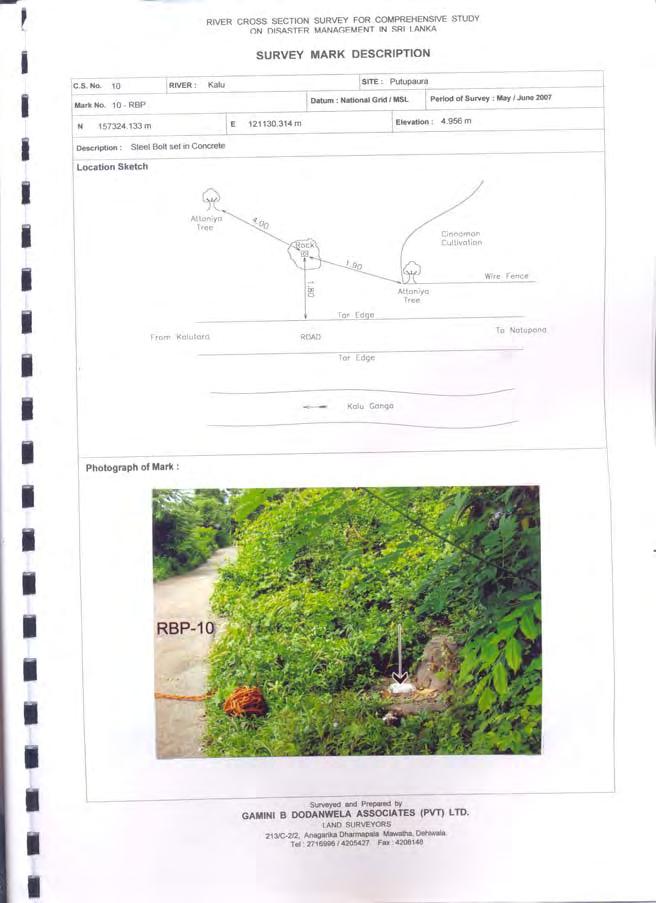
8 1.8 Surveyed Quantities The survey quantities and the details of the drawings prepared are listed as follows:. Table I.8.1 Surveyed Quantities Total Details of Drawings River Site Length of Scales CS(m) H V Sheet Size 1. Kelani Glencourse :500 1:200 A2 2. Kelani Hanwella :500 1:200 A2 3. Kelani Kaduwella :500 1:200 A2 4. Kelani Nagalagam :500 1:200 A2 5. Kalu Ratnapura :500 1:200 A2 6. Kalu Ellagawa Bridge :500 1:200 A2 7. Kalu Ellagawa :500 1:200 A2 8. Kalu Halwatura 1: Bridge 1:200 A2 9. Kalu Kalu Ganga 1: Confluence 1:200 A2 10. Kalu Putupaura :500 1:200 A2 11. Gin Tawalama :500 1:200 A2 12. Gin Agaliya :1000 1:100 A2 13. Gin Ganegama :1000 1:100 A2 14. Gin Hegoda :1000 1:100 A1 15. Nilwala Pittabeddara :1000 1:100 A2 16 Nilwala Bopagoda :500 1:200 A2 17. Nilwala Akuressa :500 1:200 A2 18. Nilwala Talgahangoda :1000 1:100 A2 In case of CS No.16, it was not able to extend the right bank survey beyond the point due to objections from the people, who prevented the Contractor from entering their lands. The Contractor had constructed the Survey Mark (BM) on the Right Bank but could not survey it because the people objected at the time of survey. The Contractor submitted a Survey Mark Location Plan below the CS Profile in each sheet to show the location of the Survey Mark (Bench Mark) with reference to the CS line. MSL Elevations at Gauge Zero as obtained by the survey are given in the respective drawings where the CS locations are at Gauging Stations. 1-4
9 1.9 Materials Delivered (1) One set of the under mentioned 1:50,000 Topographical Maps showing the locations of CSS. Table I.9.1 Location Map Submitted Topo Map CS Nos. River 1. Avissawella 1 & 2 Kelani 2. Colombo 3 & 4 Kelani 3. Ratnapura 5 to 10 Kalu 4. Matugama 11 Gin 5. Ambalangoda 12 & 13 Gin 6. Galle 14 Gin 7. Morawaka 15 to 17 Nilwala 8. Matara 18 Nilwala (2) 3 Sets of 18CS Profile drawings (Hard Copies). For details of drawings (3) CD containing 18 CS Profile data in Excel format (4) 3 Sets of 35 Survey Mark (Bench Mark) Description forms (Hard Copies), with photo of each point pasted to the form, location sketch of the respective point and other required information. (Form for No.16 RBP is not supplied as this Survey Mark could not be surveyed due to objections from the people in the area) (5) CD Containing Digital Photos of the photos pasted on the above description forms of the Survey Marks (6) CD Containing the soft copies of the Survey Mark Description Forms (7) 3 Copies of this Survey Report and a soft copy of same in a CD 1.10 Equipment Used Following Equipment were used for the survey: (1) Hand held / Portable GPS MAGALLAN Explorist Channel 3m accuracy. (2) SOKKIA Total Stations (3) SOKKIA Auto Levels (4) SOUTH SDE 28 Echo Sounder - Transducer with frequency 200 khz All drawings have been computer drawn to AutoCAD format Staff Engaged Following are the names of the key personnel who were engaged in the survey work: (1) Mr. Gamini B Dodanwela, Chief Surveyor (2) Mr. M.W.Perera, Supervising Surveyor (3) Mr. S.R.C.Ranaweera, Surveyor (4) Mr. R.A.D.Aruna Kumara, Surveyor 1-5
10 1-6
11 1-7
12 1-8
13 1-9
14 1-10
15 1-11
16 1-12
17 1-13
18 1-14
19 1-15
20 1-16
21 1-17
22 1-18
23 1-19
24 1-20
25 1-21
26 1-22
27 1-23


28 1-24


29 1-25


30 1-26

31 1-27


32 1-28


33 1-29


34 1-30


35 1-31


36 1-32

37 1-33


38 1-34


39 1-35


40 1-36


41 1-37


42 1-38


43 1-39

44 1-40
4 th Joint Project Team Meeting for Sentinel Asia 2011
 A Revisit on the Structural Flood Mitigation Measure with the Application of Remote Sensing and GIS in Gin River Basin, Sri Lanka 4 th Joint Project Team Meeting for Sentinel Asia 2011 Geoinformatics Center
Shape of the Earth. Data Output by the Receiver
 It is quite common for confusion to arise about the process used during a hydrographic survey when GPS-derived water surface elevation is incorporated into the data as an RTK Tide correction. This article
DISASTER INFORMATION MANAGEMENT SYSTEM Sri Lanka
 DISASTER INFORMATION MANAGEMENT SYSTEM Sri Lanka 15 March 2016 - Partnership Meeting Global Centre for Disaster Statistics SRIMAL SAMANSIRI ASSISTANT DIRECTOR R&D DISASTER MANAGEMENT CENTRE Overview Country
Flood Warning Systems in Sri Lanka Current situation for DRR
 Flood Warning Systems in Sri Lanka Current situation for DRR S.B.Weerakoon Department of Civil Engineering, University of Peradeniya, Sri Lanka Asian Water Cycle Symposium, 1 2 March 2016,Tokyo A2: Flood
Use of Geospatial data for disaster managements
 Use of Geospatial data for disaster managements Source: http://alertsystemsgroup.com Instructor : Professor Dr. Yuji Murayama Teaching Assistant : Manjula Ranagalage What is GIS? A powerful set of tools
12/26/2012. Geographic Information Systems * * * * GIS (... yrezaei
 ( - Geographic Information Systems ( ( 1 2 3 Information System Data base DB IS IS DB (Knowledge ( ( (System (Information System - (Georefrence Analysis Data + Knowledge ======== Information 4 5 ( < 10%
March 2007 The Survey Department of Sri Lanka
 Contribution of Survey Department of Sri Lanka for Mitigation of Disasters in Sri Lanka K.A.U.N.Kasthuri Deputy Surveyor General (Information Technology) March 2007 The Survey Department of Sri Lanka 1
Town of Chino Valley. Survey Control Network Report. mgfneerhg mc N. Willow Creek Road Prescott AZ
 Town of Chino Valley Survey Control Network Report mgfneerhg mc. 2050 N. Willow Creek Road Prescott AZ 86301 928-771-2376 Page 1 of 70 Table of Contents Town of Chino Valley Survey Datum Outline A short
INSTITUTION OF ENGINEERS (MAURITIUS)
") INSTITUTION OF ENGINEERS () THE INSTITUTION OF ENGINEERS () has the pleasure to invite you to a Technical Presentation on Chitrakoot Landslide Management Pilot Project By Messrs Kuwano, Iwasaki and Hara
INSTITUTION OF ENGINEERS () THE INSTITUTION OF ENGINEERS () has the pleasure to invite you to a Technical Presentation on Chitrakoot Landslide Management Pilot Project By Messrs Kuwano, Iwasaki and Hara
UNITED NATIONS E/CONF.96/CRP. 5
 UNITED NATIONS E/CONF.96/CRP. 5 ECONOMIC AND SOCIAL COUNCIL Eighth United Nations Regional Cartographic Conference for the Americas New York, 27 June -1 July 2005 Item 5 of the provisional agenda* COUNTRY
ch02.pdf chap2.pdf chap02.pdf
 Introduction to Geographic Information Systems 8th Edition Karl Solutions Manual Full Download: http://testbanklive.com/download/introduction-to-geographic-information-systems-8th-edition-karl-solutions-manu
GRAVITY SURVEY TEELS MARSH PROSPECT
 GRAVITY SURVEY over the TEELS MARSH PROSPECT MINERAL COUNTY, NV for Dajin Resources (US) Corp. March 2015 SUBMITTED BY Magee Geophysical Services LLC 465 Leventina Canyon Road Reno, Nevada 89523 USA TEL
Development of the Kingdom of Tonga Cyclone Emergency Recovery and Management System using Geospatial Tools
 Development of the Kingdom of Tonga Cyclone Emergency Recovery and Management System using Geospatial Tools Case Studies from Small Island States FIG Commissions 3, 7 and 8 Malcolm Archbold General Manager
FLOODS IN SOUTHWESTERN SRI LANKA IN MAY 2017
 FLOODS IN SOUTHWESTERN SRI LANKA IN MAY 2017 Foundation for Environment, Climate and Technology C/o Mahaweli Authority of Sri Lanka, Digana Village, Rajawella, Kandy, KY 20180, Sri Lanka Citation Lokuhetti,
Level 1 Geography, 2011
 91010 910100 1SUPERVISOR S Level 1 Geography, 2011 91010 Apply concepts and basic geographic skills to demonstrate understanding of a given environment 9.30 am ednesday Wednesday 2 November 2011 Credits:
REPORT ON SEA LEVEL MEASUREMENT FOR GHANA
 20TH SEPTEMBER 2006 REPORT ON SEA LEVEL MEASUREMENT FOR GHANA Emmanuel K. Nkebi 1 1 Survey Department of Ghana, P. O. Box CT903, Accra Tel: 233 21 777 334 Fax : 233 21 765687 E-mail: survey@ghana.com E-mail:eknkebi@yahoo.com
DATA SOURCES AND INPUT IN GIS. By Prof. A. Balasubramanian Centre for Advanced Studies in Earth Science, University of Mysore, Mysore
 DATA SOURCES AND INPUT IN GIS By Prof. A. Balasubramanian Centre for Advanced Studies in Earth Science, University of Mysore, Mysore 1 1. GIS stands for 'Geographic Information System'. It is a computer-based
Progress Report. Flood Hazard Mapping in Thailand
 Progress Report Flood Hazard Mapping in Thailand Prepared By: Mr. PAITOON NAKTAE Chief of Safety Standard sub-beuro Disaster Prevention beuro Department of Disaster Prevention and Mitigation THAILAND E-mail:
SURVEYING AND MAPPING, INC. COORDINATE DATA SHEET JOB: CITY OF DECATUR CLIENT: CITY OF DECATUR SAM JOB#:
 13 March 2001 SURVEYING AND MAPPING, INC. COORDINATE DATA SHEET JOB: CITY OF DECATUR CLIENT: CITY OF DECATUR SAM JOB#: 21038-20 HORIZONTAL DATUM: NAD-83 GEODETIC VERTICAL STATION ID LATITUDE LONGITUDE
QUESTIONNAIRE THE CURRENT STATUS OF MAPPING IN THE WORLD
 QUESTIONNAIRE ON THE CURRENT STATUS OF MAPPING IN THE WORLD The questionnaire is intended to take stock of the current status of mapping in the world. The information collected will eventually be used
Mainstream Space Technology in Implementing SFDRR - GPSTAR. Srimal Samansiri Disaster Management Centre Government of Sri Lanka
 Mainstream Space Technology in Implementing SFDRR - GPSTAR Srimal Samansiri Disaster Management Centre Government of Sri Lanka SFDRR Priority Actions Effective use of Space technology in SFDRR Priority
CONTROL MONUMENT REPORT
 CONTROL MONUMENT REPORT This document was prepared by Altus Geomatics for use by City of Yorkton staff and contractors working in and for the City of Yorkton. This document is meant to inform readers about
Positional Accuracy of the Google Earth Imagery In The Gaza Strip
 Positional Accuracy of the Google Earth Imagery In The Gaza Strip Maher A. El-Hallaq Associate Professor of Surveying Civil Engineering Department The Islamic University of Gaza, Palestine mhallaq@iugaza.edu.ps
BUILDING AN ACCURATE GIS
 BUILDING AN ACCURATE GIS 2006 GIS in the Rockies Denver, Colorado September 13, 2006 William E. Linzey United States Department of Commerce National Oceanic and Atmospheric Administration National Geodetic
GPS ELLIPSOID HEIGHT CALIBRATION TO DETERMINE THE APPROXIMATE MEAN SEA LEVEL (ORTHOMETRIC) HEIGHT
 HEIGHT") GPS ELLIPSOID HEIGHT CALIBRATION TO DETERMINE THE APPROXIMATE MEAN SEA LEVEL (ORTHOMETRIC) HEIGHT Dr. Abd Elrahim Elgizouli Mohamed Ahamed* Abstract: Through this paper a comparison between the ellipsoidal
GPS ELLIPSOID HEIGHT CALIBRATION TO DETERMINE THE APPROXIMATE MEAN SEA LEVEL (ORTHOMETRIC) HEIGHT Dr. Abd Elrahim Elgizouli Mohamed Ahamed* Abstract: Through this paper a comparison between the ellipsoidal
UNITED NATIONS E/CONF.97/6/IP. 33
 UNITED NATIONS E/CONF.97/6/IP. 33 ECONOMIC AND SOCIAL COUNCIL Seventeenth United Nations Regional Cartographic Conference for Asia and the Pacific Bangkok, 18-22 September 2006 Item 7 of the provisional
U.S. ARMY CORPS OF ENGINEERS
 CORPS FACTS Regulating Mississippi River Navigation Pools U.S. ARMY CORPS OF ENGINEERS BUILDING STRONG Historical Background Federal improvements in the interest of navigation on the Mississippi River
Predicting Tsunami Inundated Area and Evacuation Road Based On Local Condition Using GIS
 IOSR Journal of Environmental Science, Toxicology and Food Technology (IOSR-JESTFT) ISSN: 2319-2402, ISBN: 2319-2399. Volume 1, Issue 4 (Sep-Oct. 2012), PP 05-11 Predicting Tsunami Inundated Area and Evacuation
BANGLADESH SURVEY OF BANGLADESH PREMISES
 BANGLADESH SURVEY OF BANGLADESH PREMISES Survey of Bangladesh (SOB) is the National Mapping organization of Bangladesh SOB is carrying out all Geodetic activities of Bangladesh SOB is responsible for taking
MILITARY SPECIFICATION DIGITAL LANDMASS BLANKING (DLMB) DATA PROGRAM
 DATA PROGRAM") METRIC MIL-D-89021 15 June 1991 SUPERSEDING PS/1CJ/010 September 1983 MILITARY SPECIFICATION DIGITAL LANDMASS BLANKING (DLMB) DATA PROGRAM This specification is approved for use by all Departments and
METRIC MIL-D-89021 15 June 1991 SUPERSEDING PS/1CJ/010 September 1983 MILITARY SPECIFICATION DIGITAL LANDMASS BLANKING (DLMB) DATA PROGRAM This specification is approved for use by all Departments and
8 th 12 th Designing a Monitoring Plan Mapping & Analysis (Activities 1 2)
") 8 th 12 th Designing a Monitoring Plan Mapping & Analysis (Activities 1 2) Objectives for All Activities - To be able to define and describe the purpose and uses of topographic maps. - To define rules
8 th 12 th Designing a Monitoring Plan Mapping & Analysis (Activities 1 2) Objectives for All Activities - To be able to define and describe the purpose and uses of topographic maps. - To define rules
IMPLEMENTAION OF GIS TECHNOLOGY IN THE NILE AND ITS WADIS ABSTRACT
 IMPLEMENTAION OF GIS TECHNOLOGY IN THE NILE AND ITS WADIS Eng. NADIA M. ABD EI- SALAM 1 Dr. ABDEL AZIZ TAREK M. 2 ABSTRACT Traditional methods have been used for several years for map production of the
USGS Flood Inundation Mapping of the Suncook River in Chichester, Epsom, Pembroke and Allenstown, New Hampshire
 USGS Flood Inundation Mapping of the Suncook River in Chichester, Epsom, Pembroke and Allenstown, New Hampshire NH Water & Watershed Conference Robert Flynn, USGS NH-VT Water Science Center March 23, 2012
Outline. Shape of the Earth. Geographic Coordinates (φ, λ, z) Ellipsoid or Spheroid Rotate an ellipse around an axis. Ellipse.
 Ellipsoid or Spheroid Rotate an ellipse around an axis. Ellipse.") Map Projections Outline Geodesy and map projections Prof. D. Nagesh Kumar Department of Civil Engineering Indian Institute of Science Bangalore 560 012, India http://www.civil.iisc.ernet.in/~nagesh Shape
Map Projections Outline Geodesy and map projections Prof. D. Nagesh Kumar Department of Civil Engineering Indian Institute of Science Bangalore 560 012, India http://www.civil.iisc.ernet.in/~nagesh Shape
Grant 0299-NEP: Water Resources Project Preparatory Facility
 Document Produced under Grant Project Number: 45206 May 2016 Grant 0299-NEP: Water Resources Project Preparatory Facility Final Report Volume 3 East Rapti (1 of 9) Prepared by Pvt. Ltd. For Ministry of
The Integration of Land and Marine Spatial Data Set As Part of Indonesian Spatial Data Infrastructure Development
 UNITED NATIONS E/CONF.97/6/IP. 46 ECONOMIC AND SOCIAL COUNCIL Seventeenth United Nations Regional Cartographic Conference for Asia and the Pacific Bangkok, 18-22 September 2006 Item 7 of the provisional
Development of the Kingdom of Tonga Cyclone Emergency Recovery and Management System using Geospatial Tools
 Development of the Kingdom of Tonga Cyclone Emergency Recovery and Management System using Geospatial Tools Malcolm ARCHBOLD, New Zealand and Sione Nailasikau (Naila) HALATUITUIA, Tonga. Key words: Tonga,
Coordinate Systems. Location on earth is defined by coordinates
 Coordinate Systems We think of the earth as a sphere It is actually a spheroid (ellipsoid), slightly larger in radius at the equator than at the poles Shape of the Earth Location on earth is defined by
Trail Life USA High Adventure Training Land Navigation Module. Dennis Conte
 Trail Life USA High Adventure Training Land Navigation Module Dennis Conte Navigating With GPS and a MAP Let s Talk about your GPS Hand Held Tool. Is a GPS Hand Held the magic bullet? Can it solve all
J.B. Shaw and D. Mohrig
 GSA DATA REPOSITORY 2014008 J.B. Shaw and D. Mohrig Supplementary Material Methods Bathymetric surveys were conducted on 26 June- 4 July, 2010 (Fig. 2A), 7 March, 2011 (Fig. 2B), 11-12 August, 2011 (Figs.
3 rd Ministerial Conference and 9th Council meeting of the Regional Integrated Multi Hazard Early Warning Systems (RIMES)
") 3 rd Ministerial Conference and 9th Council meeting of the Regional Integrated Multi Hazard Early Warning Systems (RIMES) RIMES Capacity Building For Sri Lanka Department of Meteorology Sri Lanka Out Line
3 rd Ministerial Conference and 9th Council meeting of the Regional Integrated Multi Hazard Early Warning Systems (RIMES) RIMES Capacity Building For Sri Lanka Department of Meteorology Sri Lanka Out Line
Topographic Maps and Landforms Geology Lab
 Topographic Maps and Landforms Geology Lab Ray Rector: Instructor Today s Lab Activities 1) Discussion of Last Week s Lab 2) Lecture on Topo Maps and Elevation Contours 3) Construct Topographic Maps and
SECTION 4 PARCEL IDENTIFIERS 4.1 LONGITUDE AND LATITUDE
 SECTION 4 PARCEL IDENTIFIERS 4.1 LONGITUDE AND LATITUDE Most maps must be drawn in such a way that points and areas can be located accurately on the earth's surface and described objectively. A uniform
NGIAs' roles in successful disaster response
 The Second UN-GGIM-AP Plenary Meeting NGIAs' roles in successful disaster response Japan Teheran Iran 28 October 2013 Shin-ichi SAKABE, Director of International Affairs Division Geospatial Information
STATUS QUO REPORT ON ENC ACTIVITIES
 NETWORK OF DANUBE WATERWAY ADMINISTRATIONS South-East European Transnational Cooperation Programme STATUS QUO REPORT ON ENC ACTIVITIES UA - SHS Document ID: Activity: 5.2 Author / Project Partner: Date:
Chapter 3 Models of the Earth. 3.1 Finding Locations on the Earth. 3.1 Objectives
 Chapter 3 Models of the Earth 3.1 Finding Locations on the Earth 3.1 Objectives Explain latitude and longitude. How can latitude and longitude be used to find locations on Earth? How can a magnetic compass
Ayubowan. Management (CBDRM) Community Based Disaster Risk. Towards Disaster Resilient Community Developed by Disaster Management Centre,
 Community Based Disaster Risk. Towards Disaster Resilient Community Developed by Disaster Management Centre,") Ayubowan Community Based Disaster Risk Management (CBDRM) Towards Disaster Resilient Community 5-20 Purpose of this activity To know the risks in community to prepare for future disasters To exchange knowledge
Ayubowan Community Based Disaster Risk Management (CBDRM) Towards Disaster Resilient Community 5-20 Purpose of this activity To know the risks in community to prepare for future disasters To exchange knowledge
Basic Map Skills for the Outdoors
 Geography 80-20 80% of what there is to know, for 20% of the sweat Basic Map Skills for the Outdoors Map Scale Map source: US Geological Survey Four ways to indicate map scale: Representative fraction
Mapping coordinate systems
 Mapping coordinate systems 1. The Earth's Graticule Latitude and Longitude The graticule is the imaginary grid of lines running east-west (lines of latitude = parallels) and north-south lines of longitude
Disaster Management and Spatial Data An Experience of Sri Lanka for Joint project team meeting 2012
 Disaster Management and Spatial Data An Experience of Sri Lanka for Joint project team meeting 2012 1 by Padma Kumara Withana Provincial Surveyor General Uva Province 2 Out line ü Introduction ü Natural
GEO-INFORMATICS AND SPACE TECHNOLOGY FOR PROPERTIES DIGITAL TAX MAP : CASE STUDY ON LOCAL ADMINISTRATIVE WONG KONG MUNICIPALITY, PHITSANULOK, THAILAND
 GEO-INFORMATICS AND SPACE TECHNOLOGY FOR PROPERTIES DIGITAL TAX MAP : CASE STUDY ON LOCAL ADMINISTRATIVE WONG KONG MUNICIPALITY, PHITSANULOK, THAILAND Vicharn Amarakul Regional Center of Geo-Informatics
LOMR SUBMITTAL LOWER NEHALEM RIVER TILLAMOOK COUNTY, OREGON
 LOMR SUBMITTAL LOWER NEHALEM RIVER TILLAMOOK COUNTY, OREGON Prepared for: TILLAMOOK COUNTY DEPARTMENT OF COMMUNITY DEVELOPMENT 1510-B THIRD STREET TILLAMOOK, OR 97141 Prepared by: 10300 SW GREENBURG ROAD,
Protocols for cyclones and Heavy rain/torrential rain. A. Cyclones. A.1 Preliminary preparations under normal (no cyclone) conditions
 conditions") Protocols for cyclones and Heavy rain/torrential rain A. Cyclones A.1 Preliminary preparations under normal (no cyclone) conditions a) The Manager of school will ensure that for each child the School Records
Protocols for cyclones and Heavy rain/torrential rain A. Cyclones A.1 Preliminary preparations under normal (no cyclone) conditions a) The Manager of school will ensure that for each child the School Records
FLOOD HAZARD AND RISK ASSESSMENT IN MID- EASTERN PART OF DHAKA, BANGLADESH
 FLOOD HAZARD AND RISK ASSESSMENT IN MID- EASTERN PART OF DHAKA, BANGLADESH Muhammad MASOOD MEE07180 Supervisor: Prof. Kuniyoshi TAKEUCHI ABSTRACT An inundation simulation has been done for the mid-eastern
Solving the "Grid to Ground Problem" with Custom Coordinate Systems CV327-6 About the Speaker:
 Solving the "Grid to Ground Problem" with Custom Coordinate Systems Richard Sincovec, LSI Director of Technology, Edward James Surveying President, Quux Software CV327-6 Grid projections such as the State
GEOMATICS ENGINEERING / SURVEYING
 1 GEOMATICS ENGINEERING / SURVEYING CHAPTER 1 Dr. Muhammad Ashraf Javid Assistant Professor Department of Civil and Environmental Engineering Email: muhammad.javid@unizwa.edu.om 2 Geomatics Engineering
INSPIRATION RESULTS AND BENEFITS ALBANIA
 INSPIRATION RESULTS AND BENEFITS ALBANIA By Eng. Besnik Çomo Paper prepared for E&I Workshop: Support to INSPIRE Implementation in enlargement and EWP Countries JRC ISPRA Central Office of Immovable Property
Metadata for 2005 Orthophotography Products
 Metadata for 2005 Orthophotography Products What does this data set describe? 1. How should this data set be cited? 2. What geographic area does the data set cover? 3. What does it look like? 4. Does the
STUDY ON URGENT ESTABLISHMENT OF TOPOGRAPHIC MAPPING IN EAST TIMOR CREATION OF TOPOGRAPHIC INFORMATION FOR ESTABLISHMENT OF CADASTRE IN EAST TIMOR
 STUDY ON URGENT ESTABLISHMENT OF TOPOGRAPHIC MAPPING IN EAST TIMOR CREATION OF TOPOGRAPHIC INFORMATION FOR ESTABLISHMENT OF CADASTRE IN EAST TIMOR Toru WATANABE, Japan The first digital topographic mapping
Topographic Strategy National Topographic Office March 2015
 www.linz.govt.nz Topographic Strategy National Topographic Office March 2015 >> Foreword Topographic information is vital to understanding our country and its assets, and for supporting economic development.
How does an ellipsoid differ from a sphere in approximating the shape and size of the Earth?
 Chapter 02 Test Bank Worksheet Questions 1. What is a map projection? Topic: Map Projection 2. How does an ellipsoid differ from a sphere in approximating the shape and size of the Earth? Topic: Ellipsoid
Homework - Topographic Maps and What They Mean - Standard Earth Science
 Name: Mr. Schwartz Earth Science Period: Date: /10 Homework - Topographic Maps and What They Mean - Standard Earth Science Read pages 46-47 and 53-56 in your text. Then, answer the questions. Don t forget
Vulnerability of Flood Hazard in Selected Ayeyarwady Delta Region, Myanmar
 Vulnerability of Flood Hazard in Selected Ayeyarwady Delta Region, Myanmar Khin Thandar Win Department of Civil Engineering Nilar Aye Department of Civil Engineering Kyaw Zaya Htun Department of Remote
Landslide Disaster Management in Sri Lanka and Nichola Oya as a Case study. Group 16 Gamini Jayathissa Udeni Nawagamuwa
 Landslide Disaster Management in Sri Lanka and Nichola Oya as a Case study Group 16 Gamini Jayathissa Udeni Nawagamuwa Taiwan Sri lanka >2582 mm, max >5000mm NE= Nov. to Feb 1750 2500 mm >2500 mm Central
Geospatial Technologies for Resources Planning & Management
 Geospatial Technologies for Resources Planning & Management Lal Samarakoon, PhD Director, Geoinformatics Center Asian Institute of Technology, Thailand Content Geoinformatics for SDG Information Integration
UPPER COSUMNES RIVER FLOOD MAPPING
 UPPER COSUMNES RIVER FLOOD MAPPING DRAFT BASIC DATA NARRATIVE FLOOD INSURANCE STUDY SACRAMENTO COUTY, CALIFORNIA Community No. 060262 November 2008 Prepared By: CIVIL ENGINEERING SOLUTIONS, INC. 1325 Howe
SEDIMENT TRANSPORT IN RIVER MOUTH ESTUARY
 SEDIMENT TRANSPORT IN RIVER MOUTH ESTUARY Katsuhide YOKOYAMA, Dr.Eng. dredge Assistant Professor Department of Civil Engineering Tokyo Metropolitan University 1-1 Minami-Osawa Osawa, Hachioji,, Tokyo,
National Report of New Zealand
 National Report of New Zealand Prepared for GLOSS Training Course Tokyo May 2006 Glen Rowe Data Analyst Hydrographic Services Land Information New Zealand National Office 160 Lambton Quay Wellington New
INTERNATIONAL JOURNAL OF GEOMATICS AND GEOSCIENCES Volume 4, No 1, 2013
 INTERNATIONAL JOURNAL OF GEOMATICS AND GEOSCIENCES Volume 4, No 1, 2013 Copyright by the authors - Licensee IPA- Under Creative Commons license 3.0 Research article ISSN 0976 4380 Geo-informatics application
This week s topics. Week 6. FE 257. GIS and Forest Engineering Applications. Week 6
 FE 257. GIS and Forest Engineering Applications Week 6 Week 6 Last week Chapter 8 Combining and splitting landscape features and merging GIS databases Chapter 11 Overlay processes Questions? Next week
Butte County Fire Department
 Butte County Fire Department Basic Land Navigation Verification Sheet I verify that Print Supervisor s name has completed the Print Employee s name Basic Land Navigation self study guide on. Date Attached
GIS BASED ANALYSIS ON ENVIRONMENTAL SENSITIVE AREAS AND IDENTIFICATION OF THE POTENTIAL DISASTER HAZARDOUS LOCATIONS IN SOUTHERN SRI LANKA
 International Journal of Civil & Environmental Engineering IJCEE Vol: 9 No: 9-311 - GIS BASED ANALYSIS ON ENVIRONMENTAL SENSITIVE AREAS AND IDENTIFICATION OF THE POTENTIAL DISASTER HAZARDOUS LOCATIONS
Sea Level Station Operations in Commonwealth of DOMINICA
 Sea Level Station Operations in Commonwealth of DOMINICA 1. Date of report: 01 March, 2018 2. Title: Report on Sea Level Station Operations in the Commonwealth of Dominica 3. Names, addresses, tel/fax/emails
When the Earth Was Flat. Measurements were made using a plumb bob, a spirit level, and a stick. Also, the Stars.
 ABSTRACT Defining the shape of the Earth geoid. Mathematical models spheroid or ellipsoid Mathematical projection of geodetic systems GIS/GPS technology The need for a unified projection systems World
Military Map Reading 201
 Military Map Reading 201 This information paper is designed to resolve the confusion between the Universal Transverse Mercator (UTM) and the Military Grid Reference System (MGRS) coordinates. The two systems
CHAIRMAN OF THE JOINT CHIEFS OF STAFF INSTRUCTION
 CHAIRMAN OF THE JOINT CHIEFS OF STAFF INSTRUCTION J-3 CJCSI 3900.01C DISTRIBUTION: A, B, C, J POSITION (POINT AND AREA) REFERENCE PROCEDURES Reference: DODD 5105.60, 11 October 1996, National Imagery and
Flood Mapping Michael Durnin October 9 th
 Michael Durnin October 9 th 2014 Leading Surveyors Company Profile Est. 1983 Celebrating 30 Years in Business Six Offices in UK & Ireland Over 30 Specialised Survey Services ISO 9001:2008 Registered Over
GEOVEKST A Norwegian Program for Cost Sharing in Production, Updating and Administration of Geographic Data
 GEOVEKST A Norwegian Program for Cost Sharing in Production, Updating and Administration of Dr. Anne Kirsten S. HØSTMARK, Norway Key words: Mapping in large scale, formal co-operation, cost sharing, standarised
Charts and Chart Work with Poole Sailing
 with Poole Sailing Nautical charts are a mine of information but they need to be up to date. Corrections to charts are published by the Hydrographic Office monthly as Notices to Mariners both in print
Red de Observacion del Nivel del Mar para America Central (RONMAC)
") Red de Observacion del Nivel del Mar para America Central (RONMAC) Guatemala Reconnaissance Report Monday, June 19, 2000 Began with a meeting at Instituto Nacional de Sismologia Vulcanologia Meteorologia
Red de Observacion del Nivel del Mar para America Central (RONMAC) Guatemala Reconnaissance Report Monday, June 19, 2000 Began with a meeting at Instituto Nacional de Sismologia Vulcanologia Meteorologia
Leveling. 3.1 Definitions
 Leveling 3.1 Definitions Leveling is the procedure used to determine differences in elevation between points that are remote from each other. Elevation is a vertical distance above or below a reference
Integration Activities in Indonesia: The Integration of Land and Marine Spatial Data Sets as Part of Indonesian SDI Development
 Integration Activities in Indonesia: The Integration of Land and Marine Spatial Data Sets as Part of Indonesian SDI Development M. Arief Syafi i National Coordination Agency for Surveys and Mapping (B
Analysis of National Vertical Datum Using Tidal Gauge Bench Mark in KOREA
 Analysis of National Vertical Datum Using Tidal Gauge Bench Mark in KOREA Hasu YOON, YunSoo CHOI, Hungkyu LEE, MinChol ChANG, Yong HUH (Republic of KOREA) What s TBM? TBM(Tidal Bench Mark) means a national
Fundamentals of Surveying (LE/ESSE ) Lecture 10
 Lecture 10") Fundamentals of Surveying (LE/ESSE 2620 3.0) Lecture 10 Topographic Mapping Dr.-Ing. Jianguo Wang Geomatics Engineering York University Fall 2017 1 10-1 Introduction Two main types of maps: Line maps Orthophotographic
Fundamentals of Surveying (LE/ESSE 2620 3.0) Lecture 10 Topographic Mapping Dr.-Ing. Jianguo Wang Geomatics Engineering York University Fall 2017 1 10-1 Introduction Two main types of maps: Line maps Orthophotographic
Import Digital Spatial Data (Shapefiles) into OneStop
 into OneStop") Import Digital Spatial Data (Shapefiles) into OneStop» Intended User: Pipeline Licence Applicants Overview To apply for a pipeline or pipeline installation licence, applicants must upload the proposed
Import Digital Spatial Data (Shapefiles) into OneStop» Intended User: Pipeline Licence Applicants Overview To apply for a pipeline or pipeline installation licence, applicants must upload the proposed
Satellite-based applications for water resources management in Asia and Pacific region
 Satellite-based applications for water resources management in Asia and Pacific region Ko Hamamoto Japan Aerospace Exploration Agency The views expressed in this paper/presentation are the views of the
4 Survey Datums. 4.1 Horizontal Datum Policy SURVEY DATUMS SEPTEMBER 2006
 4 Survey Datums Today s multi-organizational Project Development efforts require the use of common, accurate horizontal and vertical survey datums and consistent, precise control-survey procedures to ensure
Enrico C. PARINGIT, Louie P. BALICANTA, Czar Jakiri SARMIENTO, The Philippines
 Survey Requirements for River Flood Assessment and Spatial Planning: Experiences from River Hydrographic Measurements and LIDAR Surveys in the Philippines Enrico C. PARINGIT, Louie P. BALICANTA, Czar Jakiri
Participants. Participatory Mapping. Village : Date : Page : / No. Name Job Gender. Entered by. Interviewer. Author. Checked by
 Participatory Mapping Author Interviewer Entered by Checked by Original or Copy O C File name Checked by Has been written on back? Y N Has been copied? Village Participants No. Name Job Gender 1 2 3 4
A Case Study in Land and Sea Data Interoperability
 Andrew HOGGARTH, CANADA, Gordon JOHNSTON, UNITED KINGDOM, Charles de Jongh and Peter Schwarzberg, NETHERLANDS Key words: Disaster Planning, Coast, Bathymetry, Database, Interoperability SUMMARY In Mozambique
GCSAR Navigation -- Maps
 GCSAR Navigation -- Maps From the GCSAR Certification Standards Identify and explain all the border information on a topographic map. Identify and explain the following aspects of maps: index and intermediate
MODERNIZATION OF THE MUNICIPAL MAPPING USING HIGH END GNSS SYSTEM AND GIS SOFTWARE
 MODERNIZATION OF THE MUNICIPAL MAPPING USING HIGH END GNSS SYSTEM AND GIS SOFTWARE Mr. R. A. R. Khan Assistant Engineer, Sewerage Utility Management Centre (SUMC) Municipal Corporation Of Greater Mumbai
Capacity Building Programme
 Capacity Building Programme 14-17 August 2012 Space Technology for improving Hazard Mapping in Sri Lanka An event organised as a follow up of the UN-SPIDER Technical Advisory Mission to Sri Lanka - 17-21
Application of high-resolution (10 m) DEM on Flood Disaster in 3D-GIS
 DEM on Flood Disaster in 3D-GIS") Risk Analysis V: Simulation and Hazard Mitigation 263 Application of high-resolution (10 m) DEM on Flood Disaster in 3D-GIS M. Mori Department of Information and Computer Science, Kinki University, Japan
Risk Analysis V: Simulation and Hazard Mitigation 263 Application of high-resolution (10 m) DEM on Flood Disaster in 3D-GIS M. Mori Department of Information and Computer Science, Kinki University, Japan
Acknowledgments Piloting The Art of Navigation p. 3 The Shipboard Navigation Department Organization p. 6 Duties of the Navigator p.
 Foreword p. xiii Acknowledgments p. xv Piloting The Art of Navigation p. 3 The Shipboard Navigation Department Organization p. 6 Duties of the Navigator p. 7 Relationship of the Navigator to the Command
Serial : SK1_U+I_CE_Surveying Engineering_010918
 Serial : SK1_U+I_CE_Surveying Engineering_010918 Delhi oida Bhopal Hyderabad Jaipur Lucknow Indore Pune Bhubaneswar Kolkata Patna Web: E-mail: info@madeeasy.in Ph: 011-451461 CLASS TEST 018-19 CIVIL EGIEERIG
Information (10:00), July 3, 2018
, July 3, 2018") Information (10:00), July 3, 2018 To All Missions (Embassies, Consular posts and International Organizations in Japan) Report on the discharge record and the seawater monitoring results at Fukushima Daiichi
Information (10:00), July 3, 2018 To All Missions (Embassies, Consular posts and International Organizations in Japan) Report on the discharge record and the seawater monitoring results at Fukushima Daiichi
FS Original Hole Ft April 26, 2016
 Oilfield Services, Central U.S. Land PathFinder A Schlumberger Company Drilling Group Geo Market Area: South East Texas Basin 3600 BriarPark Houston, Texas 77042 Phone : (713) 789-9600 (Main) Fax : (713)
Understanding China Census Data with GIS By Shuming Bao and Susan Haynie China Data Center, University of Michigan
 Understanding China Census Data with GIS By Shuming Bao and Susan Haynie China Data Center, University of Michigan The Census data for China provides comprehensive demographic and business information
GIS TECHNICIAN I GIS TECHNICIAN II
 GIS TECHNICIAN I GIS TECHNICIAN II CITY OF ROSEVILLE DEFINITION To perform a variety of technical office and field work duties related to the creation and maintenance of maps, tables, graphs and other