White Rock Tree Management Silverlight Application. Presented by: Boris Zanic, GIS Specialist Ying Lin, GIS/WEB Technician
|
|
|
- Arleen Kennedy
- 5 years ago
- Views:
Transcription

1 White Rock Tree Management Silverlight Application Presented by: Boris Zanic, GIS Specialist Ying Lin, GIS/WEB Technician

2 Land Area 5.28 square km Population in ,339 Population density 3,500 Median age 50.9 % of the population over 15 years - 90% 4500 Parcels Introduction
3 Organizational Overview One of the smallest City s in BC Only 2 GIS full-time professionals Enterprise GIS system, SDE database We develop in-house customized mapping solutions Focus on latest technology Trying to stay with the trend of technological change Intranet 10 customized applications Public website hosted by City of Surrey
4 Tree Management App - History: White Rock - ocean view importance Trees are considered City s value assets Trees are centerpiece of controversy Spring of 2011 Council decided on development of Tree Management App. Summer of 2011 and 2012 Data collection Spring of 2012 customized app for data collection 2013 building the Silverlight App for City Intranet Fall 2013 fully functional app
5 Data Design Arborist provided what data to be collected and how data to be used Cover all aspects of tree definition, maintenance, including work orders, tree permits, environmental impacts 17 tables 20 domains 261 Species names Entity-Relationship Diagram:
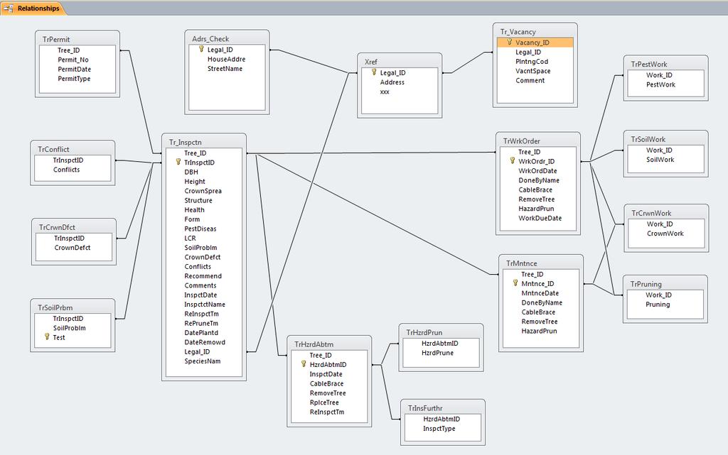
6
7 Data Collection 1 st year Spatial accuracy very important GPS GeoXH + Laser Finder Con-Net Post-processing Account 4 students all Forestry graduates with GIS knowledge 1 person doing GPS/Spatial collection + tagging trees 3 persons doing attribute collection 2 months available time slot Need for continuous collect. process adjustment & improvement
8 Data Collection Challenges Orientation on the field - just hardcopy maps available Address problems legal vs. actual address Missed trees by attribute crew Organizational All share one vehicle Waiting for one another Planning the route Coffee/Lunch brakes and GPS set-up time GPS post-processing time Visualizing what is accomplished Finding discrepancies spatial vs. attribute
9 1 st year data collection summary 1170 trees collected 29% of the total City area (no parks included) Spatial accuracy below satisfying over 300 points had to be shifted to match Orthophoto Organizational difficulties with 2 separate data collection groups Orientation difficulties on the field Lots of manual processing time in the office Conclusion: Overall collection method below satisfaction Find new data collection model for next year
10 2 nd year data collection model Don t use the GPS for the Spatial collection Custom built windows ArcGIS project application loaded on the laptop Map part with orthophoto background for manually placing tree point locations Customized form for attribute data input 3 students 3 checkouts to synchronize laptops with SDE at the end of the day Each student does all steps: spatial + attribute + tree tagging
11 Advantages: Solved all orientation problems Address is obtained from selected parcel by application No mismatched data spatial vs. attribute No missed trees Solved all organizational problems Everybody s work from today is next day on the screen of each person Much easier planning and tracking Same spatial accuracy as the year before No post-processing nor spatial adjusting data needed Very productive method
12 Final Data Collection Notes Total trees collected: st year 1170 with 4 field persons 2 nd year 4652 with 3 field persons 2 nd year 5.32 times faster (considering one person less) Covered entire City owned portion of the land 7 students in total 4 months of field data collection time Overall: very satisfaying data collection
13 Tree Applications 1. Upload/Download Data 2. Data collection 3. Tree Management Website - ArcGIS Server Silverlight API Application
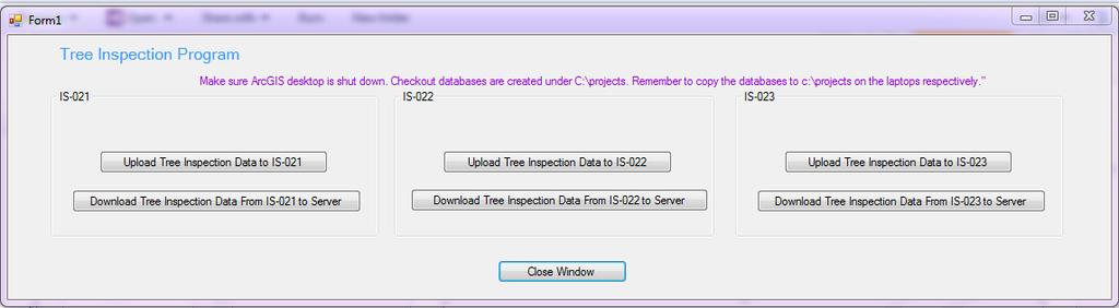
14 Upload/Download Data
15 Data Collection Installed on each laptop Simple interface Easy work flow Validate user input data
16 Data Collection Application Demo
17 Tree Management Silverlight Application Demo
18 Questions? Boris Zanic, GIS Specialist - bzanic@whiterockcity.ca Ying Lin, GIS/WEB Technician - ylin@whiterickcity.ca
Continental Divide National Scenic Trail GIS Program
 CDNST Vision Statement: Provide the most accurate geospatial locational information of the Continental Divide Trail and nearby resources to the public as well as help provide internal management information
Embracing ArcGIS Server Technology A City s Balanced Approach
 Embracing ArcGIS Server Technology A City s Balanced Approach Sridhar Katragadda Virginia Johnston Esri UC2013. About the City Virginia Beach Metropolitan Statistical Area (MSA) is the 38th largest in
Leveraging Web GIS: An Introduction to the ArcGIS portal
 Leveraging Web GIS: An Introduction to the ArcGIS portal Derek Law Product Management DLaw@esri.com Agenda Web GIS pattern Product overview Installation and deployment Configuration options Security options
GIS. in the City of Lewiston Maine
 GIS in the City of Lewiston Maine The purpose of this slideshow is to provide an overview of the city GIS and how it is used, maintained and accessed in-house as well as by the public. Please simply hit
Portal for ArcGIS: An Introduction. Catherine Hynes and Derek Law
 Portal for ArcGIS: An Introduction Catherine Hynes and Derek Law Agenda Web GIS pattern Product overview Installation and deployment Configuration options Security options and groups Portal for ArcGIS
Comptroller GIS and Property Data. Ken Morrell Assessment Systems Manager Division of Property Assessments February 22, 2007
 Comptroller GIS and Property Data Ken Morrell Assessment Systems Manager Division of Property Assessments February 22, 2007 Comptroller Divisions Using and Supporting GIS Office of Local Government Implement
Web GIS: Architectural Patterns and Practices. Shannon Kalisky Philip Heede
 Web GIS: Architectural Patterns and Practices Shannon Kalisky Philip Heede Web GIS Transformation of the ArcGIS Platform Desktop Apps Server GIS Web Maps Web Scenes Layers Web GIS Transformation of the
Introduction to Portal for ArcGIS. Hao LEE November 12, 2015
 Introduction to Portal for ArcGIS Hao LEE November 12, 2015 Agenda Web GIS pattern Product overview Installation and deployment Security and groups Configuration options Portal for ArcGIS + ArcGIS for
Introduction to Portal for ArcGIS
 Introduction to Portal for ArcGIS Derek Law Product Management March 10 th, 2015 Esri Developer Summit 2015 Agenda Web GIS pattern Product overview Installation and deployment Security and groups Configuration
Portal for ArcGIS: An Introduction
 Portal for ArcGIS: An Introduction Derek Law Esri Product Management Esri UC 2014 Technical Workshop Agenda Web GIS pattern Product overview Installation and deployment Security and groups Configuration
Enabling Web GIS. Dal Hunter Jeff Shaner
 Enabling Web GIS Dal Hunter Jeff Shaner Enabling Web GIS In Your Infrastructure Agenda Quick Overview Web GIS Deployment Server GIS Deployment Security and Identity Management Web GIS Operations Web GIS
Introduction to ArcGIS Server Development
 Introduction to ArcGIS Server Development Kevin Deege,, Rob Burke, Kelly Hutchins, and Sathya Prasad ESRI Developer Summit 2008 1 Schedule Introduction to ArcGIS Server Rob and Kevin Questions Break 2:15
Developing a Campus-wide Base Map for Planning, Design and Construction. June 21, 2007
 Developing a Campus-wide Base Map for Planning, Design and Construction June 21, 2007 Presenters Berent Pippert UCR Project Manager Capital and Physical Planning Academic Planning and Budget 951-827-2431
Oakland County Parks and Recreation GIS Implementation Plan
 Oakland County Parks and Recreation GIS Implementation Plan TABLE OF CONTENTS 1.0 Introduction... 3 1.1 What is GIS? 1.2 Purpose 1.3 Background 2.0 Software... 4 2.1 ArcGIS Desktop 2.2 ArcGIS Explorer
What s New in Collector for ArcGIS (Aurora)
") What s New in Collector for ArcGIS (Aurora) Derek Law (dlaw@esri.com) Esri Apps Product Management @GIS_Bandit Oct 10 th, 2018 Agenda Product overview Use cases Preparing data for Collector for ArcGIS
What s New in Collector for ArcGIS (Aurora) Derek Law (dlaw@esri.com) Esri Apps Product Management @GIS_Bandit Oct 10 th, 2018 Agenda Product overview Use cases Preparing data for Collector for ArcGIS
D2D SALES WITH SURVEY123, OP DASHBOARD, AND MICROSOFT SSAS
 D2D SALES WITH SURVEY123, OP DASHBOARD, AND MICROSOFT SSAS EDWARD GAUSE, GISP DIRECTOR OF INFORMATION SERVICES (ENGINEERING APPS) HTC (HORRY TELEPHONE COOP.) EDWARD GAUSE, GISP DIRECTOR OF INFORMATION
Lesson: Don t Wait For the Storm
 Lesson: Don t Wait For the Storm Developing a GIS for Plaquemines Parish, Louisiana Presented by: Daniel Mellott, GISP Burk Kleinpeter, Inc. Where is Plaquemines Parish? 1998 GIS Feasibility Study User
ArcGIS Enterprise: What s New. Philip Heede Shannon Kalisky Melanie Summers Sam Williamson
 ArcGIS Enterprise: What s New Philip Heede Shannon Kalisky Melanie Summers Sam Williamson ArcGIS Enterprise is the new name for ArcGIS for Server What is ArcGIS Enterprise ArcGIS Enterprise is powerful
ArcGIS GeoAnalytics Server: An Introduction. Sarah Ambrose and Ravi Narayanan
 ArcGIS GeoAnalytics Server: An Introduction Sarah Ambrose and Ravi Narayanan Overview Introduction Demos Analysis Concepts using GeoAnalytics Server GeoAnalytics Data Sources GeoAnalytics Server Administration
ArcGIS for Local Government
 Wednesday, June 29th ArcGIS for Local Government Dan Rose, GIS Analyst WaterOne IT/GIS Agenda / Talking Points What is the LGIM? WaterOne s GIS and LGIM background Our geodatabase redesign Our strategies
GIS is a tool for Pipeline Management
 ESRI User Conference 2011 GIS is a tool for Pipeline Management Pacheco (1) (1) Position: GIS Supervisor for Compañía Operadora de LNG del Perú. Address: Jiron Villa Real de los Infantes 255 D604, La Molina.
Web GIS & ArcGIS Pro. Zena Pelletier Nick Popovich
 Web GIS & ArcGIS Pro Zena Pelletier Nick Popovich Web GIS Transformation of the ArcGIS Platform Desktop Apps GIS Web Maps Web Scenes Layers Evolution of the modern GIS Desktop GIS (standalone GIS) GIS
An ESRI Technical Paper June 2007 An Overview of Distributing Data with Geodatabases
 An ESRI Technical Paper June 2007 An Overview of Distributing Data with Geodatabases ESRI 380 New York St., Redlands, CA 92373-8100 USA TEL 909-793-2853 FAX 909-793-5953 E-MAIL info@esri.com WEB www.esri.com
GIS Needs Assessment. for. The City of East Lansing
 GIS Needs Assessment for The City of East Lansing Prepared by: Jessica Moy and Richard Groop Center for Remote Sensing and GIS, Michigan State University February 24, 2000 Executive Summary At the request
The Impact of GIS Implementation on Increasing Business Efficiency
 The Impact of GIS Implementation on Increasing Business Efficiency Marko Maric Vladimir Stojanovic 1 July 15, 2014 San Diego Convention Center 2014 ESRI International User Conference Introduction GIS Implementation
Cobb County GIS: Beyond the Map
 Cobb County GIS: Beyond the Map Charles Fail Tim Scharff Cobb County GIS SERUG 2008 1 Topics Cobb GIS Overview The Early Years Enterprise GIS Transition Putting It Together Looking Ahead SERUG 2008 2 Cobb
THE SPATIAL DATA WAREHOUSE OF SEOUL
 THE SPATIAL DATA WAREHOUSE OF SEOUL Jae-Ho Han The Seoul Metropolitan Government Seoul City Hall, Taepyeongno 1(il)-ga, Jung-gu, Seoul 100-744, Korea djhjha@hanmail.net Impyeong Lee Dept. of Geoinformatics,
No. of Days. Building 3D cities Using Esri City Engine ,859. Creating & Analyzing Surfaces Using ArcGIS Spatial Analyst 1 7 3,139
 Q3 What s New? Creating and Editing Data with ArcGIS Pro Editing and Maintaining Parcels Using ArcGIS Spatial Analysis Using ArcGIS Pro User Workflows for ArcGIS Online Organizations Q3-2018 ArcGIS Desktop
Urban Planning Internet Geographic Information Systems Fall 2010
 Urban Planning - 794 Internet Geographic Information Systems Fall 2010 Instructor: Professor Huxhold (hux@uwm.edu) Lecturer: Melissa Mann (mmann@uwm.edu) Manager: Kurt Meingast (kurtm@uwm.edu) Schedule:
Web GIS Deployment for Administrators. Vanessa Ramirez Solution Engineer, Natural Resources, Esri
 Web GIS Deployment for Administrators Vanessa Ramirez Solution Engineer, Natural Resources, Esri Agenda Web GIS Concepts Web GIS Deployment Patterns Components of an On-Premises Web GIS Federation of Server
Empowering water/wastewater network management with GIS
 Empowering water/wastewater network management with GIS Ioannis Kavouras_GIS Manager Surveying Engineer, MSc, MBA The Company responsible for fresh water distribution & sanitation serving 1.500.000 citizens
Customer Premise Information Lookup Mapping With ArcGIS Online Jamie Patterson Senior GIS Technician
 Customer Premise Information Lookup Mapping With ArcGIS Online Jamie Patterson Senior GIS Technician January 19, 2016 Bio Jamie Patterson: ASU M.A. in Geography, 2008 10 years in the GIS industry Sr.
Transforming a Grass Roots Program to an Enterprise GIS
 Transforming a Grass Roots Program to an Enterprise GIS 2 Aqua America is the second largest, publically traded water and wastewater utility Investor owned water and wastewater utility (NYSE: WTR ) 3 million
Creating Basemaps to Manage Buildings and Facilities
 Esri International User Conference San Diego, California Technical Workshops July 26, 2012 Creating Basemaps to Manage Buildings and Facilities Mark Stewart and Tamara Yoder Topics for this Session Overview
SCAUG Community Maps Building a Living Atlas of the World
 SCAUG Community Maps Building a Living Atlas of the World Mark Stewart Topics: SCAUG ArcGIS Online Overview Community Maps Overview Community Maps Workflow Update Process Utilizing Your Contribution Community
Data Aggregation with InfraWorks and ArcGIS for Visualization, Analysis, and Planning
 Data Aggregation with InfraWorks and ArcGIS for Visualization, Analysis, and Planning Stephen Brockwell President, Brockwell IT Consulting, Inc. Join the conversation #AU2017 KEYWORD Class Summary Silos
Local Government. VALOR GIS Specialist South Georgia RDC
 Lw Low Cost GIS Sl Solutions for Local Government By: Joe Bendis VALOR GIS Specialist South Georgia RDC SERUG 2008 GIS success through cooperation $ $ VALOR Today: 5 staff members dedicated to VALOR innovations,
Enterprise Linear Referencing at the NYS Department of Transportation
 Enterprise Linear Referencing at the NYS Department of Transportation One Highway Network to Support Many Business Processes May 9, 2018 May 9, 2018 2 Agenda An overview of Linear Referencing How NYSDOT
Esri Overview for Mentor Protégé Program:
 Agenda Passionate About Helping You Succeed Esri Overview for Mentor Protégé Program: Northrop Grumman CSSS Jeff Dawley 3 September 2010 Esri Overview ArcGIS as a System ArcGIS 10 - Map Production - Mobile
Army Installation Geospatial Information and Services (IGI&S) Program Overview
 Program Overview") Army Installation Geospatial Information and Services (IGI&S) Program Overview Joshua Delmonico Geospatial Information Officer OACSIM IGI&S Program 703-602-2851 Joshua.Delmonico@hqda.army.mil 1of 11 221400
Army Installation Geospatial Information and Services (IGI&S) Program Overview Joshua Delmonico Geospatial Information Officer OACSIM IGI&S Program 703-602-2851 Joshua.Delmonico@hqda.army.mil 1of 11 221400
Application of GIS Technologies in maintenance and development of a Gas Transmission System
 Application of GIS Technologies in maintenance and development of a Gas Transmission System by Iva Juretić and Vanja Skopljak Štulić The main role of GIS, in addition to providing spatial data, is to create
Web GIS Administration: Tips and Tricks
 EdUC 2017 July 8 th, 2017 Web GIS Administration: Tips and Tricks Geri Miller Agenda Concerns Acknowledged User Management Content Management Monitoring Licensing and logins Sophistication of IT support
MODERNIZATION OF THE MUNICIPAL MAPPING USING HIGH END GNSS SYSTEM AND GIS SOFTWARE
 MODERNIZATION OF THE MUNICIPAL MAPPING USING HIGH END GNSS SYSTEM AND GIS SOFTWARE Mr. R. A. R. Khan Assistant Engineer, Sewerage Utility Management Centre (SUMC) Municipal Corporation Of Greater Mumbai
KING GEORGE COUNTY DEPARTMENT OF COMMUNITY DEVELOPMENT
 GIS REPORT 2016 KING GEORGE COUNTY DEPARTMENT OF COMMUNITY DEVELOPMENT Background The GIS (Geographic Information System) coordinator was hired in 2001 to develop a GIS for King George County. Prior to
Web GIS Patterns and Practices
 FedGIS Conference February 24 25, 2016 Washington, DC Web GIS Patterns and Practices Philip Heede Jay Theodore Witt Mathot Web GIS Transformation of the ArcGIS Platform Desktop Apps Web Maps Web Scenes
Using GIS Online for tracking development of roadway construction plans. Tom Cox Viraj Perera
 Using GIS Online for tracking development of roadway construction plans Tom Cox Viraj Perera 9 Districts District 6 Located in the Capital City Springfield, IL LAND OF LINCOLN Home to: Abraham Lincoln
GIS Geographic Information Systems
 GIS Geographic Information Systems Connecting your Community Ruekert Mielke WAUKESHA WHO WE ARE DATE ESTABLISHED 1946 SERVING LOCAL PEOPLE. SOLVING LOCAL PROBLEMS. TYPE OF ORGANIZATION Ruekert & Mielke,
Working with ArcGIS Online
 Esri International User Conference San Diego, CA Technical Workshops July 12, 2011 Working with ArcGIS Online Bern Szukalski, Deane Kensok Topics for this Session ArcGIS Online Overview ArcGIS Online Content
GIS Geographical Information Systems. GIS Management
 GIS Geographical Information Systems GIS Management Difficulties on establishing a GIS Funding GIS Determining Project Standards Data Gathering Map Development Recruiting GIS Professionals Educating Staff
June 19 Huntsville, Alabama 1
 June 19 Huntsville, Alabama 1 Real-Time Geospatial Data: The Fusion of PI and ArcGIS Enabling Smarter Facilities Management OSIsoft and Esri Mapping and Location Analytics Platform Supporting Your Use
Case Study Saginaw County, Michigan
 Case Study Saginaw County, Michigan Averaging more than 40 inches of snow a year, Saginaw County, Michigan, and its more than 196,000 residents often suffer harsh winters that would paralyze traffic if
JOB DESCRI PTI ON. GIS Administrator
 JOB DESCRI PTI ON JOB GRADE: GS-0 Cla ss Code : Office - 8 8 0 DEPARTMENT: 2 0 - FLSA: EXEMPT JOB NO: 6-0 9-2 7 SALARY: To Be De t e rm in e d Job description statements are intended to describe the general
Getting Started with Community Maps
 Esri International User Conference San Diego, California Technical Workshops July 24, 2012 Getting Started with Community Maps Shane Matthews and Tamara Yoder Topics for this Session ArcGIS is a complete
GIS Integration to Maximo
 GIS Integration to Maximo Tuesday 15 th January 2008 Mahmoud Jaafar Systems Director GISTEC Agenda Introduction Why AMS & GIS Integration? ESRI GIS Enabling Technology. Integrating GIS & Maximo. What do
CAPE FARM MAPPER - an integrated spatial portal
 CAPE FARM MAPPER - an integrated spatial portal Skukuza Dr Mike Wallace June 2017 Overview of GIS applications in WCDoA Spatial information and technology has become indispensable across a wide range of
HIGH RESOLUTION BASE MAP: A CASE STUDY OF JNTUH-HYDERABAD CAMPUS
 HIGH RESOLUTION BASE MAP: A CASE STUDY OF JNTUH-HYDERABAD CAMPUS K.Manjula Vani, Abhinay Reddy, J. Venkatesh, Ballu Harish and R.S. Dwivedi ABSTRACT The proposed work High Resolution Base map: A Case study
Leveraging ArcGIS Online Elevation and Hydrology Services. Steve Kopp, Jian Lange
 Leveraging ArcGIS Online Elevation and Hydrology Services Steve Kopp, Jian Lange Topics An overview of ArcGIS Online Elevation Analysis Using Elevation Analysis Services in ArcGIS for Desktop Using Elevation
Corporate. Information. Railway Infrastructure Administrator. Year indracompany.com
 geospatial and mobility Corporate Geographic Information System of ADIF Railway Infrastructure Administrator. Year 2009-2010 Corporate Geographic Information System of ADIF ADIF. Spanish Administrator
Geo-Enabling Mountain Bike Trail Maintenance:
 Title Slide Geo-Enabling Mountain Bike Trail Maintenance: Enhanced Stewardship of the Fountainhead Mountain Bike Trail through GIS Technology Ruthann Ligon Follow the Trail Fountainhead Mountain Bike
Crime Analyst Extension. Christine Charles
 Crime Analyst Extension Christine Charles ccharles@esricanada.com Agenda Why use Crime Analyst? Overview Tools Demo Interoperability With our old software it could take a police officer up to forty minutes
Kenneth Melchert (Senior Statistician - Regional Liaison Officer)
") Sourcing Spatial Data from Local Government Getting the Data Right The Supplier s Perspective Presenter: Kenneth Melchert (Senior Statistician - Regional Liaison Officer) Information Products and Services
Sourcing Spatial Data from Local Government Getting the Data Right The Supplier s Perspective Presenter: Kenneth Melchert (Senior Statistician - Regional Liaison Officer) Information Products and Services
Geospatial Fire Behavior Modeling App to Manage Wildfire Risk Online. Kenyatta BaRaKa Jackson US Forest Service - Consultant
 Geospatial Fire Behavior Modeling App to Manage Wildfire Risk Online Kenyatta BaRaKa Jackson US Forest Service - Consultant Fire Behavior Modeling and Forest Fuel Management Modeling Fire Behavior is an
Bringing GIS to the Front Lines Author- Mike Masters Co-Author James Kelt
 Pearland, Texas and Enterprise Wide GIS Bringing GIS to the Front Lines Author- Mike Masters Co-Author James Kelt Presenters Mike Masters- GIS Coordinator The City of Pearland, Texas Richard DeLa Mater-
The File Geodatabase API. Craig Gillgrass Lance Shipman
 The File Geodatabase API Craig Gillgrass Lance Shipman Schedule Cell phones and pagers Please complete the session survey we take your feedback very seriously! Overview File Geodatabase API - Introduction
CHAPTER 22 GEOGRAPHIC INFORMATION SYSTEMS
 CHAPTER 22 GEOGRAPHIC INFORMATION SYSTEMS PURPOSE: This chapter establishes the administration and use of to improve the quality and accessibility of Department s spatial information and support graphical
SHOW ME THE DATA. FEMA Region 6 Community Assistance Visits Findings Collector
 SHOW ME THE DATA FEMA Region 6 Community Assistance Visits Findings Collector Roberto Ramirez, CFM / ASFPM June 4, 2015 Topics of Discussion Overview of CAV Findings Collection project Why a GIS Based
Mapping Your Land and Introduction to Web Soil Survey. Elizabeth Cook GIS Specialist USDA-NRCS (retired)
") Mapping Your Land and Introduction to Web Soil Survey Elizabeth Cook GIS Specialist USDA-NRCS (retired) Using Geographic Information Systems (GIS), Global Positioning System (GPS), digital aerial photography
Mapping Your Land and Introduction to Web Soil Survey Elizabeth Cook GIS Specialist USDA-NRCS (retired) Using Geographic Information Systems (GIS), Global Positioning System (GPS), digital aerial photography
Administering your Enterprise Geodatabase using Python. Jill Penney
 Administering your Enterprise Geodatabase using Python Jill Penney Assumptions Basic knowledge of python Basic knowledge enterprise geodatabases and workflows You want code Please turn off or silence cell
What s Happening in My Watershed?
 What s Happening in My Watershed? How Implementing a GIS system to Utilize Spatial Data and Digital Collection Techniques can help Solve Watershed Issues. Mindi J. Parsell City of Tulsa Stormwater Quality
Utilizing GIS as a Critical Campus. Karen Jordan February 24, 2011
 Utilizing GIS as a Critical Campus Resource Karen Jordan February 24, 2011 Agenda Campus Background Opportunity for a Campus-wide GIS Data Structure and Collection How Has GIS Been Utilized on Campus Over
How GIS can support the Production
 How GIS can support the Production of Local Development Plans ESRI User Conference 2017 Mandy Maas ARUP Who we are Shaping a better world We are an independent firm of designers, planners, engineers, consultants
Developing a Subdivision Build- Out Study and Site Suitability Tool; Enabling Access Through a Web GIS Application
 Developing a Subdivision Build- Out Study and Site Suitability Tool; Enabling Access Through a Web GIS Application DOUG SEXTON GEOG 596A SUMMER 2017 ADVISOR: DR. JAMES O BRIEN Project Outline Introduction
Steve Pietersen Office Telephone No
 Steve Pietersen Steve.Pieterson@durban.gov.za Office Telephone No. 031 311 8655 Overview Why geography matters The power of GIS EWS GIS water stats EWS GIS sanitation stats How to build a GIS system EWS
No. of Days. ArcGIS 3: Performing Analysis ,431. Building 3D cities Using Esri City Engine ,859
 What s New? Creating Story Maps with ArcGIS Field Data Collection and Management Using ArcGIS Get Started with Insights for ArcGIS Introduction to GIS Using ArcGIS & ArcGIS Pro: Essential Workflow Migrating
No. of Days. ArcGIS Pro for GIS Professionals ,431. Building 3D cities Using Esri City Engine ,859
 What s New? Creating Story Maps with ArcGIS Field Data Collection and Management Using ArcGIS Get Started with Insights for ArcGIS Introduction to GIS Using ArcGIS & ArcGIS Pro: Essential Workflow Migrating
City of Marquette. Geographic Information Systems (GIS) Global Positioning Systems (GPS)
 Global Positioning Systems (GPS)") City of Marquette Geographic Information Systems (GIS) Global Positioning Systems (GPS) Presented by: Matthew Koss GIS Engineering Technician Email- makoss@mqtcty.org The main focus of my job at the City
City of Marquette Geographic Information Systems (GIS) Global Positioning Systems (GPS) Presented by: Matthew Koss GIS Engineering Technician Email- makoss@mqtcty.org The main focus of my job at the City
ArcGIS Urban: An Introduction. Lisa Staehli ArcGIS Urban Team Product Development Brooks Patrick ArcGIS Urban Team Business Development
 ArcGIS Urban: An Introduction Lisa Staehli ArcGIS Urban Team Product Development Brooks Patrick ArcGIS Urban Team Business Development Our Cities Are Facing Massive Challenges Our Cities Are Facing Massive
Geo-enabling a Transactional Real Estate Management System A case study from the Minnesota Dept. of Transportation
 Geo-enabling a Transactional Real Estate Management System A case study from the Minnesota Dept. of Transportation Michael Terner Executive Vice President Co-author and Project Manager Andy Buck Overview
KING GEORGE COUNTY DEPARTMENT OF COMMUNITY DEVELOPMENT
 GIS REPORT 2017 KING GEORGE COUNTY DEPARTMENT OF COMMUNITY DEVELOPMENT Background The GIS (Geographic Information System) manager was hired in 2001 to develop a GIS for King George County. Prior to 2001,
GIS at the Regional District
 GIS at the Regional District Amanda Spendiff Outline Introduction What is a Regional District? Our GIS department What does the GIS department do? Data management & mapping 9-1-1 fire/dispatch support
Annual TTFO Meeting April 10, 2018 Michael J. Wittman, P.S. Chief Surveyor / GIS Coordinator
 Annual TTFO Meeting April 10, 2018 Michael J. Wittman, P.S. Chief Surveyor / GIS Coordinator Text Book Definition: Layman Terms: An organized collection of hardware, software and geographic data designed
Introduction-Overview. Why use a GIS? What can a GIS do? Spatial (coordinate) data model Relational (tabular) data model
 data model Relational (tabular) data model") Introduction-Overview Why use a GIS? What can a GIS do? How does a GIS work? GIS definitions Spatial (coordinate) data model Relational (tabular) data model intro_gis.ppt 1 Why use a GIS? An extension
Introduction-Overview Why use a GIS? What can a GIS do? How does a GIS work? GIS definitions Spatial (coordinate) data model Relational (tabular) data model intro_gis.ppt 1 Why use a GIS? An extension
GIS Boot Camp for Education June th, 2011 Day 1. Instructor: Sabah Jabbouri Phone: (253) x 4854 Office: TC 136
 x 4854 Office: TC 136") GIS Boot Camp for Education June 27-30 th, 2011 Day 1 Instructor: Sabah Jabbouri Phone: (253) 833-9111 x 4854 Office: TC 136 Email: sjabbouri@greenriver.edu http://www.instruction.greenriver.edu/gis/ Summer
GIS Boot Camp for Education June 27-30 th, 2011 Day 1 Instructor: Sabah Jabbouri Phone: (253) 833-9111 x 4854 Office: TC 136 Email: sjabbouri@greenriver.edu http://www.instruction.greenriver.edu/gis/ Summer
Map Application Progression
 Map Application Progression Application Migration with Latest ArcGIS by Dean Chiang California Department of Fish and Wildlife What we do at CDFW Hunting and fishing licensing and regulation Conservation
Demystifying ArcGIS Online. Karen Lizcano Esri
 Demystifying ArcGIS Online Karen Lizcano Esri An Integrated Web GIS Platform Desktop Web Device Powered by Services Managed via Portal Access from any Device Portal Server Online Content and Services ArcGIS
A Summary of State DOT GIS Activities. Presented at the 2000 AASHTO GIS-T Symposium Minneapolis, MN
 A Summary of State DOT GIS Activities Presented at the 2000 AASHTO GIS-T Symposium Minneapolis, MN Information Sources E-mail survey of state DOT GIS managers 49 State DOTs responded in 2000 Results compared
Data Aggregation with InfraWorks and ArcGIS for Visualization, Analysis, and Planning
 CI125230 Data Aggregation with InfraWorks and ArcGIS for Visualization, Analysis, and Planning Stephen Brockwell Brockwell IT Consulting Inc. Sean Kinahan Brockwell IT Consulting Inc. Learning Objectives
LRS Task Force June 13, REVISION HISTORY
 North Carolina Department of Transportation Geographic Information Systems (GIS) Unit LINEAR REFERENCING SYSTEM (LRS) PROJECT DEFINITION Version 1.0 REVISION HISTORY Date Document Manager Revision Purpose
GPS Mapping with Esri s Collector App. What We ll Cover
 GPS Mapping with Esri s Collector App Part 1: Overview What We ll Cover Part 1: Overview and requirements Part 2: Preparing the data in ArcGIS for Desktop Part 3: Build a web map in ArcGIS Online Part
FHWA GIS Outreach Activities. Loveland, Colorado April 17, 2012
 FHWA GIS Outreach Activities Loveland, Colorado April 17, 2012 GIS for Improved Decision Making FHWA believes that geographic information systems and other geospatial technologies (remote sensing and GPS)
St. Kitts and Nevis Heritage and Culture
 St. Kitts and Nevis Heritage and Culture Eloise Stancioff, Habiba, Departmet of Culture St. Kitts HERA workshop: March 17-20, 2015 Goals Using freely available open source platforms, we implement two different
The University of Arizona Enterprise GIS. CFTA 2016 Facilities Geospatial Technologies Showcase
 The University of Arizona Enterprise GIS CFTA 2016 Facilities Geospatial Technologies Showcase Main Campus: Tucson, Arizona Founded: 1885 Number of Buildings: 227 GSF: 9.4 million Acres: 393 Total Students:
How does ArcGIS Server integrate into an Enterprise Environment? Willy Lynch Mining Industry Specialist ESRI, Denver, Colorado USA
 How does ArcGIS Server integrate into an Enterprise Environment? Willy Lynch Mining Industry Specialist ESRI, Denver, Colorado USA wlynch@esri.com ArcGIS Server Technology Transfer 1 Agenda Who is ESRI?
esri.com/apps Copyright 2017 Esri. All rights reserved.
 ArcGIS Apps esri.com/apps Copyright 2017 Esri. All rights reserved. 159913 G79379 ArcGIS Apps Survey123 for ArcGIS Included with ArcGIS Survey123 for ArcGIS Create survey style forms to capture accurate
Administering Your Enterprise Geodatabase using Python. Gerhard Trichtl
 Administering Your Enterprise Geodatabase using Python Gerhard Trichtl What is the Geodatabase What is the Geodatabase A physical store of geographic data - Scalable storage model supported on different
ESRI Survey Summit August Clint Brown Director of ESRI Software Products
 ESRI Survey Summit August 2006 Clint Brown Director of ESRI Software Products Cadastral Fabric How does Cadastral fit with Survey? Surveyors process raw field observations Survey measurements define high-order
ArcGIS Deployment Pattern. Azlina Mahad
 ArcGIS Deployment Pattern Azlina Mahad Agenda Deployment Options Cloud Portal ArcGIS Server Data Publication Mobile System Management Desktop Web Device ArcGIS An Integrated Web GIS Platform Portal Providing
Evaluating e-government : implementing GIS services in Municipality
 Evaluating e-government : implementing GIS services in Municipality Municipality of Thessaloniki - G.I.S. Unit Misirloglou Symeon Head of the GIS Unit ESRI UC - 2016 The GIS Section - subset of the department
Arcmap Manual Esri 10 READ ONLINE
 Arcmap Manual Esri 10 READ ONLINE If searching for a book Arcmap manual esri 10 in pdf form, then you have come on to the loyal site. We present the utter release of this book in PDF, doc, DjVu, epub,
Spread over a central peninsula and its surroundings, Split's greater area includes the surrounding seaside towns as well.
 Split is a Mediterranean city on the eastern shores of the Adriatic Sea, centered around the ancient Roman Palace of the Emperor Diocletian and its bay and port. With a population of 178,192 citizens,