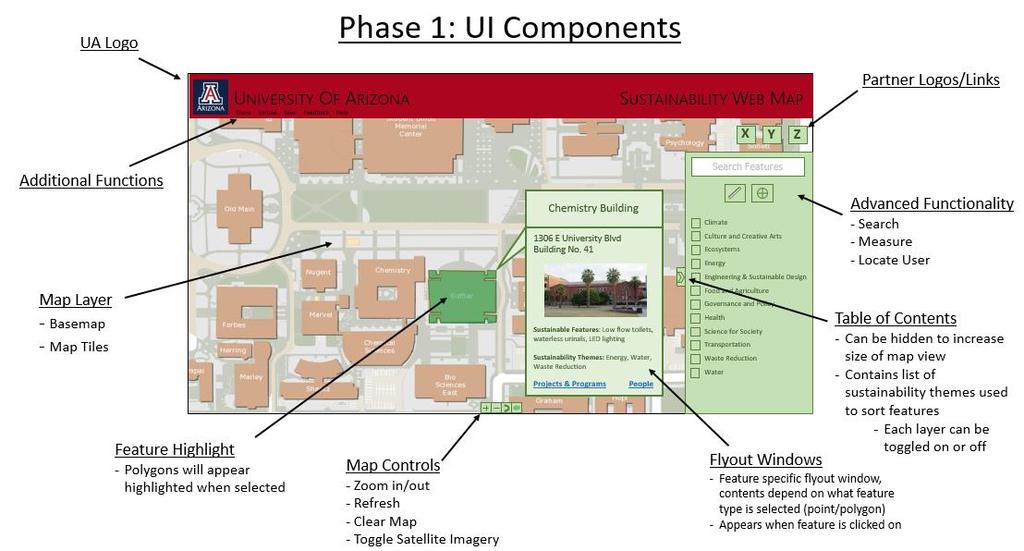
The University of Arizona Enterprise GIS. CFTA 2016 Facilities Geospatial Technologies Showcase
|
|
|
- David Greer
- 5 years ago
- Views:
Transcription

1 The University of Arizona Enterprise GIS CFTA 2016 Facilities Geospatial Technologies Showcase

2 Main Campus: Tucson, Arizona Founded: 1885 Number of Buildings: 227 GSF: 9.4 million Acres: 393 Total Students: 42,236 Total Employees: 15,615 UA Overview Two Branch Campuses and numerous other sites around the state
3 Department Organization
4 Discussion Topics Background on the UA Enterprise GIS Configuration of the System Today Current and Future Projects


5 Departmental System Vision for Enterprise


6 Departmental System Vision for Enterprise

7 Departmental System Vision for Enterprise


8 Custom Products and Analyses Visitor / Directory Map Spring Fling Guide Development Density Analysis

9 Departmental System Vision for Enterprise Enterprise System Demonstration


10 Departmental System Vision for Enterprise Enterprise System Demonstration


11 Web Map Applications: maps.arizona.edu Public Map Campus 360 Map PDC Projects Map Arizona Mobile Map Arizona Impact Map


12 Departmental System Vision for Enterprise Enterprise System Demonstration Enterprise System Full Implementation


13 Departmental System Vision for Enterprise Enterprise System Demonstration Enterprise System Full Implementation
14 UA Enterprise GIS Today Current Configuration


15 Enterprise GeoDatabase Data Maintainers, Map Makers, Analysts Common GeoDatabase Web Map Applications Other Data Systems


16 Enterprise GeoDatabase Administration Capital Projects, UA Site Points Statewide, Athletic Sites, Land Parcels, Web Cameras Arboretum Trees, Tree Descriptions Hydro Drainage structures, watersheds, water harvesting features Site Features Signs, Bluelight Emergency Phones, Public Art, Automated External Defibrillators (AEDs) Structures Building Entrances, Building Roof & Footprints, Misc. Structures Transportation Parking Spaces & Lots, Bike Parking & Paths, Shuttles, Streets, Walks Utilities Light Poles, tunnels, water lines


17 Web Server Production Map Services Production GIS Servers Application / Code Beta / Test GIS Server & Map Services Web Map Applications The EGIS/Esri Framework provides: Ready to go infrastructure An integrated platform Security Up to date and accurate information Control over branded and internal info Integrated enterprise information Expandability Responsiveness Read-Only Copy File Geodatabse SDE Enterprise GeoDatabase
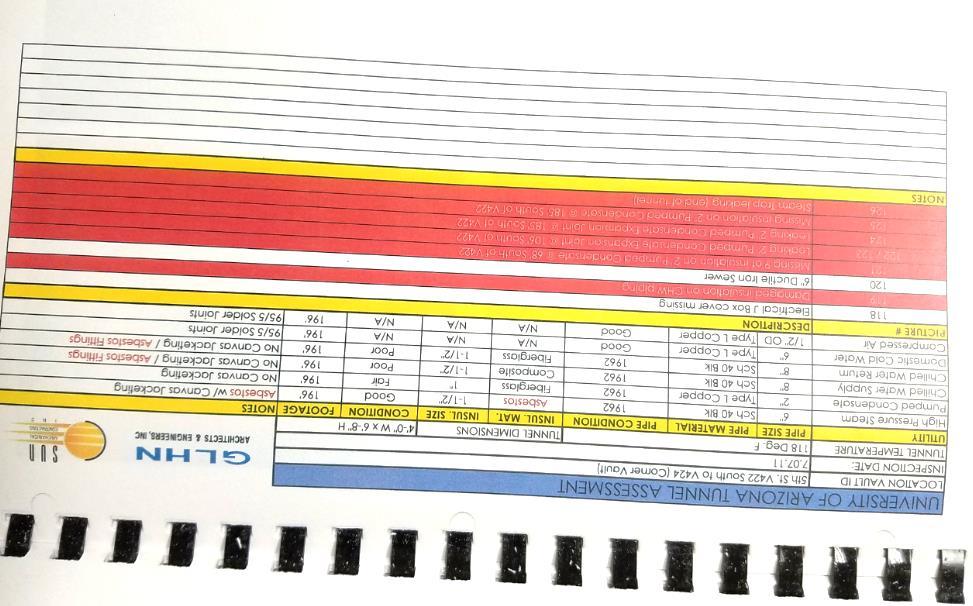
18 Campus Needs Supported Operations Public Safety Public Info Marketing Project Delivery Enterprise GIS Student Services University Analytics Physical Planning Wayfinding
19 Current GIS Projects New GIS Data, Services, and Applications Arboretum / FM Grounds Field App Sustainability Web Map 3D Building Data Utility Mapping Room / Interior Mapping
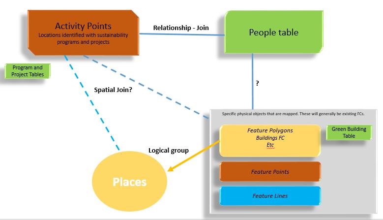
20 Sustainability Web Map / Database

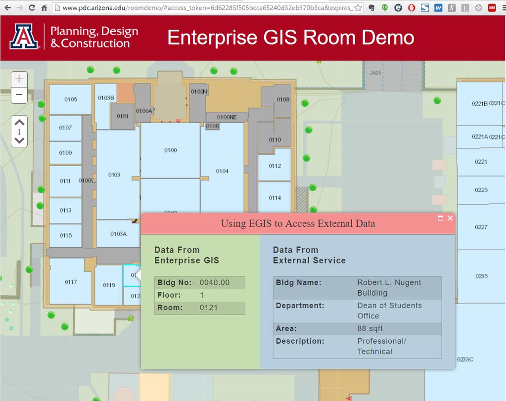
21 Arboretum / FM Grounds Field App

22 3D Buildings


23 Utility Mapping UA Utility Typology ESRI Data Model Initial Goal: Define where components are and what they are


24 Utility Report

25 Source Data for Tunnels / Contents

26 Tunnel Mapping Cross-Section Vault


27 Web Map Access to Utility Information Access Levels Public: Tiled image basemaps. Dynamic features Business Intelligence: Dynamic features, Admin / Planning focus Infrastructure: Dynamic features, Facilities, assets, utilities, focus Emergency: Dynamic features, Emergency response focus
28 Room / Interior Mapping Deep Dive Introduction Drennen Brown, Assistant Director IT and Spatial Services Opportunities from merging with Space Management (Space Analysis, Management, Reporting) Managing 1100 CAD Floor Plans in around 230 Main Campus buildings Why integrate floor plans with GIS? Asset management Room / class scheduling Location services RCM (Responsibility Centered Mgmt) analysis Worker scheduling and routing Life and safety Space analysis tools All in the context of a relational Enterprise GIS! How could we automate this?
29 Room / Interior Mapping Automation Process Building Blocks Leveraging what we have Georeferencing GIS Feature Creation Scripts Demonstration Applications Practical Applications


30 Room / Interior Mapping ARCHIBUS is CAFM (Computer Aided Facility Management) software Whats great? Whats not? Discovery of drawing-name + CAD handle CAD File Space Database Hidden Field handle
31 Leveraging Archibus Room / Interior Mapping Room Polygons already drawn Already associated with rich database Leveraging Prior GIS work Many floor plans already georeferenced

32 Room / Interior Mapping Stitching it together - Georeferencing


33 Batch File Room / Interior Mapping ArcPy Script importfloorplan.py CAD files are named by Bldg/Floor ArcPy Script Converts CAD Polygons to GIS Features Re-creates database keys used by Archibus Joins GIS features to matching database records
34 GIS Room Service Room / Interior Mapping Goal not to create every application Stand up a service for other developers Current Partners Facilities Management Custodial Routing, Shop Order Routing College of Agriculture Space / RCM App Hazardous Waste Location and Categorization of materials
35 Mashup Demonstation
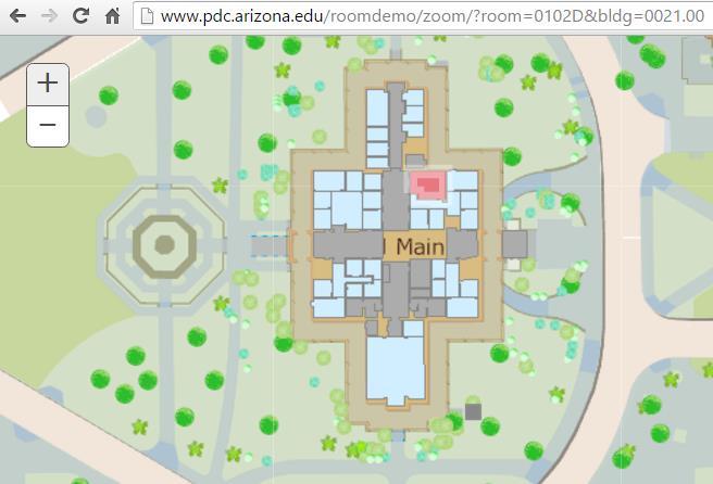
36 Zoom to Room Demonstration

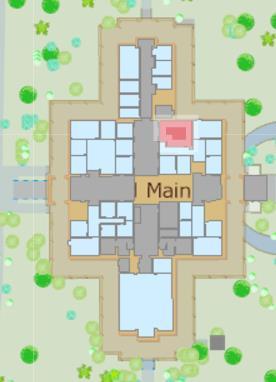
37 Zoom to Room Demonstration Location

38 CALS Space Exchange Map
39 Room / Interior Mapping Where Are We / Where are we going? Started in April Cleaning up Source Data Working on full automation Presentation Reach out and education
40 Thank you! Drennen Brown Assistant Director, Information Technology and Spatial Services Planning, Design and Construction Grant McCormick GIS Manager and Campus Planner Planning, Design and Construction
Utilizing GIS as a Critical Campus. Karen Jordan February 24, 2011
 Utilizing GIS as a Critical Campus Resource Karen Jordan February 24, 2011 Agenda Campus Background Opportunity for a Campus-wide GIS Data Structure and Collection How Has GIS Been Utilized on Campus Over
Your Perfect 3D World (BIM and GIS Integrated)
") Your Perfect 3D World (BIM and GIS Integrated) June 2015 Larisa Kruger Background Larisa Kruger- Enterprise GIS Manager FITS- Facilities Information Technology Services 2 years (GIS for 15) 2 FTE, 4 students
Your Perfect 3D World (BIM and GIS Integrated) June 2015 Larisa Kruger Background Larisa Kruger- Enterprise GIS Manager FITS- Facilities Information Technology Services 2 years (GIS for 15) 2 FTE, 4 students
Data Aggregation with InfraWorks and ArcGIS for Visualization, Analysis, and Planning
 Data Aggregation with InfraWorks and ArcGIS for Visualization, Analysis, and Planning Stephen Brockwell President, Brockwell IT Consulting, Inc. Join the conversation #AU2017 KEYWORD Class Summary Silos
Developing a Campus-wide Base Map for Planning, Design and Construction. June 21, 2007
 Developing a Campus-wide Base Map for Planning, Design and Construction June 21, 2007 Presenters Berent Pippert UCR Project Manager Capital and Physical Planning Academic Planning and Budget 951-827-2431
Facilities Geospatial Technologies Showcase
 Facilities Geospatial Technologies Showcase January June 2015 9 Campuses 12 Webinars This event is approved for GIS Education Points Organized by: The University of Kentucky Presentation Schedule 6 th
Creating a Staff Development Plan with Esri
 Creating a Staff Development Plan with Esri Michael Green David Schneider Guest Presenter: Shane Feirer, University of California Esri UC 2014 Technical Workshop Agenda What is a Staff Development Plan?
HIGH RESOLUTION BASE MAP: A CASE STUDY OF JNTUH-HYDERABAD CAMPUS
 HIGH RESOLUTION BASE MAP: A CASE STUDY OF JNTUH-HYDERABAD CAMPUS K.Manjula Vani, Abhinay Reddy, J. Venkatesh, Ballu Harish and R.S. Dwivedi ABSTRACT The proposed work High Resolution Base map: A Case study
Introduction to Portal for ArcGIS. Hao LEE November 12, 2015
 Introduction to Portal for ArcGIS Hao LEE November 12, 2015 Agenda Web GIS pattern Product overview Installation and deployment Security and groups Configuration options Portal for ArcGIS + ArcGIS for
Oklahoma GIS for GeoCIP
 GeoCIP Program Partners Oklahoma GIS for GeoCIP A Center for Spatial Analysis Report to Oklahoma GI Council 6 November 2009 The CSA team Kathy Hines Tran Trung Semiha Caliskan Peter Camili Scott March
ArcGIS Pro 3D Workflows. Zena Pelletier
 ArcGIS Pro 3D Workflows Zena Pelletier 3D as a GIS capability Core part of the platform Desktop Web Device Combine 2D and 3D in the same web GIS architecture Reuse dynamic services across clients Securely
Esri Overview for Mentor Protégé Program:
 Agenda Passionate About Helping You Succeed Esri Overview for Mentor Protégé Program: Northrop Grumman CSSS Jeff Dawley 3 September 2010 Esri Overview ArcGIS as a System ArcGIS 10 - Map Production - Mobile
Portal for ArcGIS: An Introduction
 Portal for ArcGIS: An Introduction Derek Law Esri Product Management Esri UC 2014 Technical Workshop Agenda Web GIS pattern Product overview Installation and deployment Security and groups Configuration
Introduction to Portal for ArcGIS
 Introduction to Portal for ArcGIS Derek Law Product Management March 10 th, 2015 Esri Developer Summit 2015 Agenda Web GIS pattern Product overview Installation and deployment Security and groups Configuration
Map Services Are We Getting It?
 Map Services Are We Getting It? Rich Herrmann VP Global Platforms & Technology, IHS James Sanders Senior Product Manager, IHS April 19, 2011 Houston, TX USA Overview The Challenge Keith Fraley s 2010 PUG
ArcGIS for Local Government
 Wednesday, June 29th ArcGIS for Local Government Dan Rose, GIS Analyst WaterOne IT/GIS Agenda / Talking Points What is the LGIM? WaterOne s GIS and LGIM background Our geodatabase redesign Our strategies
Cobb County GIS: Beyond the Map
 Cobb County GIS: Beyond the Map Charles Fail Tim Scharff Cobb County GIS SERUG 2008 1 Topics Cobb GIS Overview The Early Years Enterprise GIS Transition Putting It Together Looking Ahead SERUG 2008 2 Cobb
An Enterprise Geodatabase: Montgomery County, Maryland ESRI 2004 User Conference Paper #1674
 An Enterprise Geodatabase: Montgomery County, Maryland ESRI 2004 User Conference Paper #1674 1.0 ABSTRACT Montgomery County, Maryland has a long history of supporting GIS applications with a SDE/ArcSDE
Getting Started with Community Maps
 Esri International User Conference San Diego, California Technical Workshops July 24, 2012 Getting Started with Community Maps Shane Matthews and Tamara Yoder Topics for this Session ArcGIS is a complete
ArcGIS. for Server. Understanding our World
 ArcGIS for Server Understanding our World ArcGIS for Server Create, Distribute, and Manage GIS Services You can use ArcGIS for Server to create services from your mapping and geographic information system
Geospatial Preservation: State of the Landscape. A Quick Overview. Steve Morris NCSU Libraries
 Geospatial Preservation: State of the Landscape A Quick Overview Steve Morris NCSU Libraries SAA 2011 August 26, 2011 14 Brief Overview of the Problem 15 Variety of Geospatial Data Types Variety of producers
GIS for 3D Object Generation, Modelling, and Exploitation. Paul Hardy Esri
 GIS for 3D Object Generation, Modelling, and Exploitation Paul Hardy Esri ArcGIS has long understood 3D Multipatch data type in geodatabase - 3D volumetric objects - Collection of triangles, strips, fans,
7 GEOMATICS BUSINESS SOLUTIONS - ANNUAL REPORT 2006
 7 GEOMATICS BUSINESS SOLUTIONS - ANNUAL REPORT 2006 The Planning and Economic Development Committee recommends the adoption of the recommendation contained in the following report November 30, 2006, from
Workforce Development Enables Your Adoption Strategy
 Workforce Development Enables Your Adoption Strategy Michael Green Organizational Adoption Consultant Matthew Karl Training Consultant Agenda Adopt, Embrace, Utilize Components of Change Management Workforce
GIS Integration to Maximo
 GIS Integration to Maximo Tuesday 15 th January 2008 Mahmoud Jaafar Systems Director GISTEC Agenda Introduction Why AMS & GIS Integration? ESRI GIS Enabling Technology. Integrating GIS & Maximo. What do
Esri s Living Atlas of the World Community Maps
 Esri s Living Atlas of the World Community Maps Seth Sarakaitis Wednesday May 7, 2014 ArcGIS Living Atlas Concept Living Atlas Content Tour Contributing to the Living Atlas (Community Maps) Seth Sarakaitis
Working with ArcGIS Online
 Esri International User Conference San Diego, CA Technical Workshops July 12, 2011 Working with ArcGIS Online Bern Szukalski, Deane Kensok Topics for this Session ArcGIS Online Overview ArcGIS Online Content
About the Presenter. Dr. Nassim Al-Abed. Transport
 1. معلومات أساسية عن الداي رة Abu Dhabi Department of Transport Enterprise GIS Application GeoTRANS Presented by: Dr. Nassim Al-AbedAbed GIS Section March 28, 2011 24th Annual GIS-T Symposium Hershey,
CHAPTER 22 GEOGRAPHIC INFORMATION SYSTEMS
 CHAPTER 22 GEOGRAPHIC INFORMATION SYSTEMS PURPOSE: This chapter establishes the administration and use of to improve the quality and accessibility of Department s spatial information and support graphical
Creating Basemaps to Manage Buildings and Facilities
 Esri International User Conference San Diego, California Technical Workshops July 26, 2012 Creating Basemaps to Manage Buildings and Facilities Mark Stewart and Tamara Yoder Topics for this Session Overview
Strategies for Integrating CAD and BIM in ArcGIS. Don Kuehne Esri 3D Product Manager: CAD/BIM/AEC
 Strategies for Integrating CAD and BIM in ArcGIS Don Kuehne Esri 3D Product Manager: CAD/BIM/AEC CAD Digital Drawing CAD in ArcGIS Desktop CAD in Desktop CAD as Data CAD as a Map EXPORT TO CAD Create and
June 19 Huntsville, Alabama 1
 June 19 Huntsville, Alabama 1 Real-Time Geospatial Data: The Fusion of PI and ArcGIS Enabling Smarter Facilities Management OSIsoft and Esri Mapping and Location Analytics Platform Supporting Your Use
ArcGIS Online Routing and Network Analysis. Deelesh Mandloi Matt Crowder
 ArcGIS Online Routing and Network Analysis Deelesh Mandloi Matt Crowder Introductions Who are we? - Members of the Network Analyst development team Who are you? - Network Analyst users? - ArcGIS Online
Esri and GIS Education
 Esri and GIS Education Organizations Esri Users 1,200 National Government Agencies 11,500 States & Regional Agencies 30,800 Cities & Local Governments 32,000 Businesses 8,500 Utilities 12,600 NGOs 11,000
GIS for Crime Analysis. Building Better Analysis Capabilities with the ArcGIS Platform
 GIS for Crime Analysis Building Better Analysis Capabilities with the ArcGIS Platform Crime Analysis The Current State One of the foundations of criminological theory is that three things are needed for
Tools to Assess Local Health Needs. Richard Leadbeater, Esri NACo 2011 Healthy Counties Forum December 1, 2011
 Tools to Assess Local Health Needs Richard Leadbeater, Esri NACo 2011 Healthy Counties Forum December 1, 2011 Richard Leadbeater currently holds the position of Industry Solutions Manager with Esri. He
Exelis and Esri Technologies for Defense and National Security. Cherie Muleh
 Exelis and Esri Technologies for Defense and National Security Cherie Muleh Cherie.Muleh@exelisinc.com ENVI IMAGERY AND DATA BECOME KNOWLEDGE > Add information from imagery to your GIS > Automated workflows
Web GIS Administration: Tips and Tricks
 EdUC 2017 July 8 th, 2017 Web GIS Administration: Tips and Tricks Geri Miller Agenda Concerns Acknowledged User Management Content Management Monitoring Licensing and logins Sophistication of IT support
ArcGIS for Desktop. ArcGIS for Desktop is the primary authoring tool for the ArcGIS platform.
 ArcGIS for Desktop ArcGIS for Desktop ArcGIS for Desktop is the primary authoring tool for the ArcGIS platform. Beyond showing your data as points on a map, ArcGIS for Desktop gives you the power to manage
Esri Training by Microcenter Prepare to Innovate. Microcenter Course Catalog
 Esri Training by Microcenter Prepare to Innovate 2015 Instructor-Led Courses Microcenter Course Catalog ArcGIS Foundational Courses Designed to meet the learning needs of professionals whose GIS experience
GeoHealth Applications Platform ESRI Health GIS Conference 2013
 GeoHealth Applications Platform ESRI Health GIS Conference 2013 Authors Thomas A. Horan, Ph.D. Professor, CISAT Director April Moreno Health GeoInformatics Ph.D. Student Brian N. Hilton, Ph.D. Clinical
Visualizing Big Data on Maps: Emerging Tools and Techniques. Ilir Bejleri, Sanjay Ranka
 Visualizing Big Data on Maps: Emerging Tools and Techniques Ilir Bejleri, Sanjay Ranka Topics Web GIS Visualization Big Data GIS Performance Maps in Data Visualization Platforms Next: Web GIS Visualization
ArcGIS Enterprise: What s New. Philip Heede Shannon Kalisky Melanie Summers Sam Williamson
 ArcGIS Enterprise: What s New Philip Heede Shannon Kalisky Melanie Summers Sam Williamson ArcGIS Enterprise is the new name for ArcGIS for Server What is ArcGIS Enterprise ArcGIS Enterprise is powerful
Improving Business Decisions for Existing Buildings with BIM and GIS
 Improving Business Decisions for Existing Buildings with BIM and GIS Ken Bragg European Services Manager, Safe Software @kenatsafe GeoBIM Europe Dec. 11 th 2015 FME FME Technology Capabilities Translate
Leveraging ArcGIS Server Technology
 Leveraging ArcGIS Server Technology A Local Government Approach Virginia Johnston GIS Systems Analyst Virginia Beach 39 th Largest city in the United States 438,000 Residents City by the Sea Located in
Introduction-Overview. Why use a GIS? What can a GIS do? Spatial (coordinate) data model Relational (tabular) data model
 data model Relational (tabular) data model") Introduction-Overview Why use a GIS? What can a GIS do? How does a GIS work? GIS definitions Spatial (coordinate) data model Relational (tabular) data model intro_gis.ppt 1 Why use a GIS? An extension
Introduction-Overview Why use a GIS? What can a GIS do? How does a GIS work? GIS definitions Spatial (coordinate) data model Relational (tabular) data model intro_gis.ppt 1 Why use a GIS? An extension
Oman NSDI Supporting Economic Development. Saud Al-Nofli Director of Spatial Data Directorate General of NSDI, NCSI
 Oman NSDI Supporting Economic Development 2017 Saud Al-Nofli Director of Spatial Data Directorate General of NSDI, NCSI "It s critical to make correct decisions the first time to optimize the Investments
Esri User Conference 2018 Video Topics
 Esri User Conference 2018 Video Topics 3D GIS 3D Across ArcGIS 3D Analysis Tools in ArcGIS Pro 3D Cartographic Techniques: An Introduction 3D Data: Lidar Point Clouds and 3D Mesh 3D Feature and Sub-Surface
ArcGIS Enterprise: What s New. Philip Heede Shannon Kalisky Melanie Summers Shreyas Shinde
 ArcGIS Enterprise: What s New Philip Heede Shannon Kalisky Melanie Summers Shreyas Shinde ArcGIS Enterprise is the new name for ArcGIS for Server ArcGIS Enterprise Software Components ArcGIS Server Portal
Leveraging Web GIS: An Introduction to the ArcGIS portal
 Leveraging Web GIS: An Introduction to the ArcGIS portal Derek Law Product Management DLaw@esri.com Agenda Web GIS pattern Product overview Installation and deployment Configuration options Security options
ArcGIS Urban: An Introduction. Lisa Staehli ArcGIS Urban Team Product Development Brooks Patrick ArcGIS Urban Team Business Development
 ArcGIS Urban: An Introduction Lisa Staehli ArcGIS Urban Team Product Development Brooks Patrick ArcGIS Urban Team Business Development Our Cities Are Facing Massive Challenges Our Cities Are Facing Massive
Enhance Security, Safety and Efficiency With Geospatial Visualization
 Areas within 10 minutes of an exit are emphasized on this map, to give an indication of how accessible neighborhoods are by highway. The colors represent 1, 3, 5 and 10 minute increments from the exits.
Portal for ArcGIS: An Introduction. Catherine Hynes and Derek Law
 Portal for ArcGIS: An Introduction Catherine Hynes and Derek Law Agenda Web GIS pattern Product overview Installation and deployment Configuration options Security options and groups Portal for ArcGIS
Geography for the 2020 Round of Census
 Boundaries Key Census Data EA Id Population Male Female EA Id Area EA Id Num HH Avg HH size Geography for the 2020 Round of Census Linda Peters, Esri lpeters@esri.com Integration of Statistical and Geospatial
SUPPORTS SUSTAINABLE GROWTH
 DDSS BBUUN NDDLLEE G E O S P AT I A L G O V E R N A N C E P A C K A G E SUPPORTS SUSTAINABLE GROWTH www.digitalglobe.com BRISBANE, AUSTRALIA WORLDVIEW-3 30 CM International Civil Government Programs US
Joanne N. Halls, PhD Dept. of Geography & Geology David Kirk Information Technology Services
 Joanne N. Halls, PhD Dept. of Geography & Geology David Kirk Information Technology Services Geographic Information Systems manage and analyze data to solve spatial problems. Real World Abstraction Analysis
No. of Days. Building 3D cities Using Esri City Engine ,859. Creating & Analyzing Surfaces Using ArcGIS Spatial Analyst 1 7 3,139
 Q3 What s New? Creating and Editing Data with ArcGIS Pro Editing and Maintaining Parcels Using ArcGIS Spatial Analysis Using ArcGIS Pro User Workflows for ArcGIS Online Organizations Q3-2018 ArcGIS Desktop
SCAUG Community Maps Building a Living Atlas of the World
 SCAUG Community Maps Building a Living Atlas of the World Mark Stewart Topics: SCAUG ArcGIS Online Overview Community Maps Overview Community Maps Workflow Update Process Utilizing Your Contribution Community
ESRI Survey Summit August Clint Brown Director of ESRI Software Products
 ESRI Survey Summit August 2006 Clint Brown Director of ESRI Software Products Cadastral Fabric How does Cadastral fit with Survey? Surveyors process raw field observations Survey measurements define high-order
 Boone County GIS has the right to inquire about and investigate the use of any requested products and deny access to anyone based on concerns relating to privacy, security, public health, public safety,
An Introduction to the Community Maps Information Model
 Esri International User Conference July 23 27 San Diego Convention Center An Introduction to the Community Maps Information Model Seth Sarakaitis Agenda Overview of Community Maps Program Information Models
Geodatabase Replication for Utilities Tom DeWitte Solution Architect ESRI Utilities Team
 Geodatabase Replication for Utilities Tom DeWitte Solution Architect ESRI Utilities Team 1 Common Data Management Issues for Utilities Utilities are a distributed organization with the need to maintain
Chapter : 1 : Introduction of GIS
 History of GIS : Chapter : 1 : Introduction of GIS In 1960 the Department of Forestry and Rural Department of Canada has decided to pursue a large-scale project to manage the resources. The initial task
Maricopa County Department of Transportation (MCDOT) GIS Innovations in Transportation Asset Management
 GIS Innovations in Transportation Asset Management") Maricopa County Department of Transportation (MCDOT) GIS Innovations in Transportation Asset Management Presented By Steve Hossack, GIS Database Administrator 2018 ITE/IMSA Spring Conference Maricopa County
Maricopa County Department of Transportation (MCDOT) GIS Innovations in Transportation Asset Management Presented By Steve Hossack, GIS Database Administrator 2018 ITE/IMSA Spring Conference Maricopa County
Is Your GIS Ready For Grid Modernization? A State-of-the Industry Report
 Is Your GIS Ready For Grid Modernization? A State-of-the Industry Report Is Your GIS Ready For Grid Modernization? Survey Overview In the first quarter of 2019, Energy Acuity conducted a grid modernization
Evaluating e-government : implementing GIS services in Municipality
 Evaluating e-government : implementing GIS services in Municipality Municipality of Thessaloniki - G.I.S. Unit Misirloglou Symeon Head of the GIS Unit ESRI UC - 2016 The GIS Section - subset of the department
A New Approach to GIS at the Ministry for Primary Industries New Zealand
 A New Approach to GIS at the Ministry for Primary Industries New Zealand Alana Corney and André Post Geospatial Management Team www.mpi.govt.nz 1 Overview Who we are and what we do Our Approach Building
You are Building Your Organization s Geographic Knowledge
 You are Building Your Organization s Geographic Knowledge And Increasingly Making it Available Sharing Data Publishing Maps and Geo-Apps Developing Collaborative Approaches Citizens Knowledge Workers Analysts
Managing Parcels in ArcGIS 10
 Managing Parcels in ArcGIS 10 ArcGIS Geodatabase Editing Workflows Editing Maps Tim Hensley Esri Solution Engineer Karen Lowrey Esri Geospatial Analyst Basemaps Public Access Value Analysis ArcGIS 10 Parcel
Why You Should Invest in an Address Point Layer
 A GeoComm White Paper June 6, 2012 601 West Saint Germain St. St. Cloud, MN 56301 1.866.GEO.COMM Identifying 9-1-1 Caller Location By John Brosowsky, GeoComm Product Development Director Nathan Ekdahl,
ArcGIS Platform For NSOs
 ArcGIS Platform For NSOs Applying GIS and Spatial Thinking to Official Statistics Esri UC 2014 Demo Theater Applying GIS at the NSO Generic Statistical Business Process Model (GSBPM) 1 Specify Needs 2
Houston Plat Tracker puts the GIS in Land Development
 Houston Plat Tracker puts the GIS in Land Development Abstract: The Plat Tracker supports Houston's land development approval process. This home grown web-based system includes GIS research tools and a
DP Project Development Pvt. Ltd.
 Dear Sir/Madam, Greetings!!! Thanks for contacting DP Project Development for your training requirement. DP Project Development is leading professional training provider in GIS technologies and GIS application
GIS and Governing Anchorage. GIS Critical for Efficient, Transparent Government How is GIS Program Doing Where can GIS Program Take us
 GIS and Governing Anchorage GIS Critical for Efficient, Transparent Government How is GIS Program Doing Where can GIS Program Take us Municipality of Anchorage Office of Economic And Community Development
Geo-Enabling Mountain Bike Trail Maintenance:
 Title Slide Geo-Enabling Mountain Bike Trail Maintenance: Enhanced Stewardship of the Fountainhead Mountain Bike Trail through GIS Technology Ruthann Ligon Follow the Trail Fountainhead Mountain Bike
Introduction to ArcGIS Maps for Office. Greg Ponto Scott Ball
 Introduction to ArcGIS Maps for Office Greg Ponto Scott Ball Agenda What is Maps for Office? Platform overview What are Apps for the Office? ArcGIS Maps for Office features - Visualization - Geoenrichment
How does ArcGIS Server integrate into an Enterprise Environment? Willy Lynch Mining Industry Specialist ESRI, Denver, Colorado USA
 How does ArcGIS Server integrate into an Enterprise Environment? Willy Lynch Mining Industry Specialist ESRI, Denver, Colorado USA wlynch@esri.com ArcGIS Server Technology Transfer 1 Agenda Who is ESRI?
Introduction to ArcGIS Server - Creating and Using GIS Services. Mark Ho Instructor Washington, DC
 Introduction to ArcGIS Server - Creating and Using GIS Services Mark Ho Instructor Washington, DC Technical Workshop Road Map Product overview Building server applications GIS services Developer Help resources
JOB DESCRI PTI ON. GIS Administrator
 JOB DESCRI PTI ON JOB GRADE: GS-0 Cla ss Code : Office - 8 8 0 DEPARTMENT: 2 0 - FLSA: EXEMPT JOB NO: 6-0 9-2 7 SALARY: To Be De t e rm in e d Job description statements are intended to describe the general
GIS Monroe Geographic Information System March 14, 2018
 GIS Monroe Geographic Information System March 14, 2018 Goals Maintain Enterprise/County-wide geo-database Increase spatial accuracy of data Build and acquire more data layers Increase use of GIS; as another
MODERNIZATION OF THE MUNICIPAL MAPPING USING HIGH END GNSS SYSTEM AND GIS SOFTWARE
 MODERNIZATION OF THE MUNICIPAL MAPPING USING HIGH END GNSS SYSTEM AND GIS SOFTWARE Mr. R. A. R. Khan Assistant Engineer, Sewerage Utility Management Centre (SUMC) Municipal Corporation Of Greater Mumbai
Incorporating ArcGIS Pro in your Curriculum
 AAG, Boston 2017 April 5, 2017 Incorporating ArcGIS Pro in your Curriculum Geri Miller Agenda Concerns Acknowledged Learning curve ArcGIS Pro does not have all the tools (perception) Licensing and offline
GIS FOR PLANNING. Course Overview. Schedule. Instructor. Prerequisites. Urban Planning 792 Thursday s 5:30-8:10pm SARUP 158
 GIS FOR PLANNING Urban Planning 792 Thursday s 5:30-8:10pm SARUP 158 Schedule Class/Lab - SARUP 158 Thursdays 5:30pm - 8:10pm Office Hours - By Appointment Project Ideas - Week 4 Final - 5/10/2018 Instructor
IMPLEMENTING GOVERNMENT-WIDE ENTERPRISE GIS; THE FEDERATED MODEL
 IMPLEMENTING GOVERNMENT-WIDE ENTERPRISE GIS; THE FEDERATED MODEL James E. Mitchell, Ph. D. IT GIS Manager Louisiana Department of Transportation and Development presented at the ESRI International Users
GIS-T 2010 Building a Successful Geospatial Data Sharing Framework: A Ohio DOT Success Story
 GIS-T 2010 Building a Successful Geospatial Data Sharing Framework: A Ohio DOT Success Story ODOT District 2 GIS John Puente District 1 GIS Coordinator\ Planning Administrator 2 Interoperability 3 District
Enterprise Linear Referencing at the NYS Department of Transportation
 Enterprise Linear Referencing at the NYS Department of Transportation One Highway Network to Support Many Business Processes May 9, 2018 May 9, 2018 2 Agenda An overview of Linear Referencing How NYSDOT
The Pace of Change Is Accelerating Creating Many Challenges
 VISION The Pace of Change Is Accelerating Creating Many Challenges Evidence Threatening Our Natural World and Our Future as Humans Social Conflict Mass Migration Ocean Acidification Food Population Urbanization
ArcGIS 10.1 An Overview of the System
 ArcGIS 10.1 An Overview of the System ArcGIS 10.1 An Overview of the System Damian Spangrud Director of Solutions, Esri Redlands, CA USA ArcGIS 10.1 Web Cloud Online Mobile Enterprise Desktop ArcGIS 10.1
A People Strategy for Organizations
 Workforce Development Planning: A People Strategy for Organizations Michael Green, Training Sales Manager Tamara Adamson, Training Consultant Agenda Change Workforce Development Plan Breakout Session Case
Business Model for sustainable regional development by tourism
 Business Model for sustainable regional development by tourism Why EuroVeloPark Banat? Steps to Success Action proposal 1. Drawing of the Basis Map 2. Data Acquisition, POIs, etc. 3. Printed Map and Distribution
Using OGC standards to improve the common
 Using OGC standards to improve the common operational picture Abstract A "Common Operational Picture", or a, is a single identical display of relevant operational information shared by many users. The
CRP 514 SUBMITTED. Alkaf I Farid. Mohammad
 CRP 514 Campus Web Map for Final Term Project Repor rt BY Mohammad Alkaf I Farid S. Binbeshr ID # 201001160 ID # 201001900 SUBMITTED TO Instructor : Dr. Baqer Al Ramadan DATE JUN. 1, 2012 1 Table of Contents
GEOGRAPHIC INFORMATION SYSTEMS AND IT SOLUTIONS FOR THE ENVIRONMENT
 GEOGRAPHIC INFORMATION SYSTEMS AND IT SOLUTIONS FOR THE ENVIRONMENT Mission We focus on Solutions is a worldwide operating business offering Geographic Information Systems and IT solutions to assist environmental
GIS TECHNICIAN I GIS TECHNICIAN II
 GIS TECHNICIAN I GIS TECHNICIAN II CITY OF ROSEVILLE DEFINITION To perform a variety of technical office and field work duties related to the creation and maintenance of maps, tables, graphs and other
GIS at the Regional District
 GIS at the Regional District Amanda Spendiff Outline Introduction What is a Regional District? Our GIS department What does the GIS department do? Data management & mapping 9-1-1 fire/dispatch support
Enabling Web GIS. Dal Hunter Jeff Shaner
 Enabling Web GIS Dal Hunter Jeff Shaner Enabling Web GIS In Your Infrastructure Agenda Quick Overview Web GIS Deployment Server GIS Deployment Security and Identity Management Web GIS Operations Web GIS
Imagery and the Location-enabled Platform in State and Local Government
 Imagery and the Location-enabled Platform in State and Local Government Fred Limp, Director, CAST Jim Farley, Vice President, Leica Geosystems Oracle Spatial Users Group Denver, March 10, 2005 TM TM Discussion
Overview. Project Background Project Approach: Content and Application Development Application Demonstration Future Developments
 Overview Project Background Project Approach: Content and Application Development Application Demonstration Future Developments Southeast Pressures: Continued Population Growth Transportation Corridors
ENV208/ENV508 Applied GIS. Week 1: What is GIS?
 ENV208/ENV508 Applied GIS Week 1: What is GIS? 1 WHAT IS GIS? A GIS integrates hardware, software, and data for capturing, managing, analyzing, and displaying all forms of geographically referenced information.
What s New in Collector for ArcGIS (Aurora)
") What s New in Collector for ArcGIS (Aurora) Derek Law (dlaw@esri.com) Esri Apps Product Management @GIS_Bandit Oct 10 th, 2018 Agenda Product overview Use cases Preparing data for Collector for ArcGIS
What s New in Collector for ArcGIS (Aurora) Derek Law (dlaw@esri.com) Esri Apps Product Management @GIS_Bandit Oct 10 th, 2018 Agenda Product overview Use cases Preparing data for Collector for ArcGIS
Why GIS & Why Internet GIS?
 Why GIS & Why Internet GIS? The Internet bandwagon Internet mapping (e.g., MapQuest) Location-based services Real-time navigation (e.g., traffic) Real-time service dispatch Business Intelligence Spatial