The EAGLE concept - first practical implementations. Title. Stephan Arnold. Position Gebhard Banko. Place, Copenhagen, date 20.
|
|
|
- Candice Jennings
- 6 years ago
- Views:
Transcription


1 The EAGLE concept - first practical implementations Title Stephan Arnold DeStatis First name SURNAME Position Gebhard Banko Environment Name of the entity Agency Austria Place, Copenhagen, date 20. October2015
2 Content Motivation and Background EAGLE work results, sequence of work Semantics: from classification to description of land cover objects EAGLE matrix / model Semantic testing EAGLE matrix population & comparison tool Physical data: EAGLE data base Geometric test case Linking COPERNICUS, INSPIRE and national activities Overview and outlook 2
3 Preamble: Who and what is EAGLE? EAGLE = EIONET Action Group on Land Monitoring in Europe Representatives of NRC, CLC project managers, national land monitoring managers Established in 2009 as self-initiative working group Open membership based on own commitment Consortium: since 2014 funded by EEA contracts Main ideas Harmonisation of semantic description of land cover objects Increase and enable the comparability of products Integration of bottom-up and top-down approaches in land monitoring 3
4 CORINE Land Cover Recent approaches Integral part of COPERNICUS programme One piece of total picture (HR Layers, local components, etc.) LCML land cover modelling language ISO standard and System to create/describe land cover classes Referenced in INSPIRE Embedded description Integration in EAGLE work INSPIRE land cover data specifications Rules for syntactically correct data model (formal description) no mandatory semantic harmonisation mandatory for NEW datasets 21. October 2015!! 4
5 Ambiguity of Classification systems: Definitions of Forest all over the World 100 Source: Comber et al. (2005) Crown cover density[%] 20 Minimum tree height in [m]
6 Criteria for EAGLE data model Clear separation between LC and LU Complete coverage of themes LC and LU Object-oriented description instead of classification Scale independent Modelling of temporal phenomena Applicable on national and European level Extension to INSPIRE Land Cover data model 6
7 Integration scheme for future Land Monitoring- Framework in Europa [C O P E R N I C U S] European Level CLC Urban Atlas HR Layers LPIS LUCAS EAGLE Concept National & Sub-National Level National (A) Land Monitoring Regional (a) Land Monitoring National CLC Regional (b) Land Monitoring National (B) Land Monitoring 7
8 EEA-EAGLE tasks: Oct Sept Task content lead semantic physical DB grid 1.1 Explanatory documentation Stephan Arnold x 1.2 Fine-tuning Barbara Kosztra (FÖMI) x 1.3 Data model Gebhard Banko (UBA-V) x 2.1 Database development Nuria Valcárcel (CNIG) x 2.2 Semantic testing Stephan Arnold x 3.1 Matrix population and Tomas Soukup (Gisat) x comparison tool 3.2 Generalisation and aggregation rules set Henrik F. Mathiesen (NFLI) 4.1 Geometric test case Nuria Valcárcel (CNIG) x 4.2 Grid approach Geir Harald Strand (NFLI) x 5.1 Final database Nuria Valcárcel (CNIG) x 5.2 Maintenance procdures Stephan Arnold 5.3 Alignment of technical output Geoff Smith (SN) 6.1 Transformation rules for CLC Gebhard Banko (UBA-V) x x 6.2 Transformation rules for UA Lena Halin-Pihlatie (SYKE) x x x 8
9 Sequence of work Semantics: from classification to description of land cover objects EAGLE matrix / model Semantic testing EAGLE matrix population & comparison tool Physical data: EAGLE data base Geometric test case Linking COPERNICUS, INSPIRE and national activities 9
10 Structure of EAGLE matrix A.) LAND COVER Components LCC Abiotic (Artificial + Natural), Vegetation, Water Surfaces B.) LAND USE Attributes LUA Agriculture, Forestry, Residential, Transportation etc. C.) CHARACTERISTICS CH spatial pattern, bio-physical parameters, ecosystem types, cultivation measures, land management practices etc. 10
11 De-Composition of CORINE Land Cover classes LC LU CH Parameter/ Intensity Folie 11

![2) - Translation of national Land Cover Classes CORINE Land Cover [EEA] LUCAS [Eurostat] Urban Atlas](/docs-images/80/82297135/images/12-2.jpg "2012 [EEA/DG Regio] EUNIS habitat classification [DG ENV] LPIS land cover types [JRC] National level")
12 13 Tested LC/LU nomenclatures (fully / partly) 628 different classes EU level Semantic testing of EAGLE matrix (Task 2.2) - Translation of national Land Cover Classes CORINE Land Cover [EEA] LUCAS [Eurostat] Urban Atlas 2012 [EEA/DG Regio] EUNIS habitat classification [DG ENV] LPIS land cover types [JRC] National level Bulgaria & Romania Hungary Netherlands Spain Germany Austria United Kingdom Switzerland 12
 - Bar Coding Method Expressing class")
 Bar code values: mandatory / optional /")
13 Semantic testing of EAGLE matrix (Task 2.2) - Bar Coding Method Expressing class definitions with matrix elements (LCC, LUA, CH) Bar code values: mandatory / optional / excluded element 13
14 EAGLE matrix population and comparison tool (Task 3.1) EAGLE matrix in Excel format easy for insiders => Web-based tool for decomposition of classes Self-explaining and user-friendly interface Assign nomenclature and class name/code Library of de-composed classes Visual comparison between classes Import/Export function (under construction) Quantitative similarity indicator (on to do list) URL: 14


15 EAGLE matrix population and comparison tool 15


16 EAGLE matrix population & comparison tool 16
17 Sequence of work Semantics: from classification to description of land cover objects EAGLE matrix / model Semantic testing EAGLE matrix population & comparison tool Physical data: EAGLE data base Geometric test case Linking COPERNICUS, INSPIRE and national activities 17
18 Physical database implementation Store, maintain and query data (INSPIRE extension) Impossible with shape-file EAGLE Concept Data model Database hierarchical structure, data volume, ISO/OGC compliance, Selected platforms: PostgreSQL PostGIS, ESRI EAGLE Matrix UML/EA PostGIS/ ESRI Geodatabase 18


19 Physical database implementation Entity relationship diagramm (ERD) Constellation of database elements from sources of INSPIRE and EAGLE
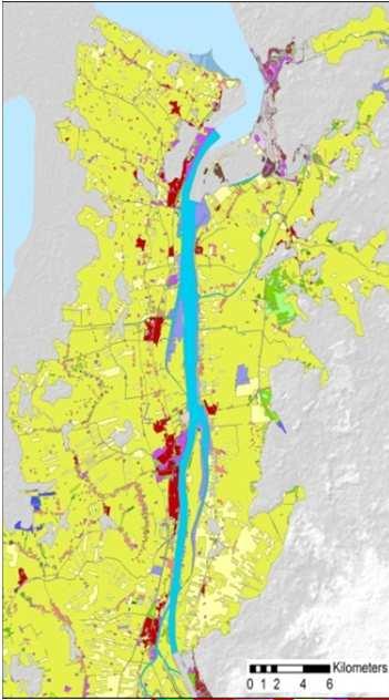
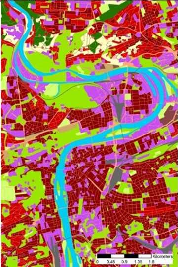
20 EAGLE Geometric Test Case Selected test sites AT, BG/RO, ES, PT, FI, HU, NL each 20*20 km2 Data imported national datasets into EAGLE database CORINE Land Cover 2012 High Resolution Layers Goals Bottom-up aggregation of national data Describe CLC-polygons with national data (enrichment) Comparison on CLC-polygon level Description with National data Description with High resolution layers
21 National datasets Original MMU National datasets in EAGLE format Base Geometry: CLC 25 ha MMU Generalized National datasets in EAGLE format FIN FIN FIN SIOSE COS Iberian Iberian LPIS CBC Loading process LPIS CBC Generalization process LPIS CBC LISA LISA LISA LGN7 LGN7 LGN7 European datasets CLC HRL Loading process European datasets in EAGLE format CLC+ HRL Comparison


22 Enhanced description of CLC polygons CLC geometries black outlines, class codes Colored thematic content from nat. data in EAGLE data model
23 Harmonisation HarmonisationandStandardisation Pilot project on INSPIRE implementation CORINE Land Cover and Urban Atlas Matching Table FME-transformation GML output validation cook book for countries Transformation of national LC data into INSPIRE Reminder Annex II: 21. October 2015 Standardisation EAGLE optimized for object description LCML optimized for class description Link to LCML/ISO Harmonisation EAGLE -> LCML (ISO :2012) Aim: joint (global) domain model for LC/LU 23
24 Semantic tools Conclusions/ Results Web-based EAGLE matrix population and comparison tool Description of Land Cover Classifications using EAGLE data model E.g. CLC-nomenclature Moving from human readible description to machine readible description Physical database Database TEMPLATE file (ESRI, PostGIS) example database filled with national and COPERNICUS data Enhancement of CLC-polygon description (object oriented) Possibility for validation Class description vs. Object (Polygon) description Harmonised and standardised: INSPIRE extension and ISO compatible Next connected presentations Grid-approach Proposal for future land monitoring (task 5.3) 24


25 Thankyouverymuchforyourattention andfortrustin ourvision) in the name of the EAGLE consortium members and working group colleagues Antonin Orlik, Antonio Arozarena Villar, Andreas Littkopf, Alejandro Simon Colina, Gebhard Banko, Barbara Kosztra, Cesar Martinez Izquierdo, Christoph Perger, Charlotte Steinmeier, Elise Järvenpää, Emanuele Mancosu, Gebhard Banko, Gerard Hazeu, Geir-Harald Strand, Gergely Maucha, Geoff Smith, Henrik Forsberg Mathiesen, Julian Delgado Hernandez, Kathrin Renner, Markus Törmä, Marc Zebisch, Mario Caetano, Michael Bock, Mirko Gregor, Nuria Valcarcel Sanz, Pavel Milenov, Radko Radkov, Roger Milego, Ruth Sonnenschein, Stefan Kleeschulte, Stephan Arnold, Suvi Hatunen, Tomas Soukup Stephan Arnold [DeStatis] Gebhard Banko [EAA] 25
Towards a harmonised land monitoring system: NRC bottom-up activities in EAGLE and HELM H
 B. Kosztra Towards a harmonised land monitoring system: NRC bottom-up activities in EAGLE and HELM H Gebhard Banko Environment Agency Austria Geoland 2 Forum 18.-19. October 2012 Copenhagen 1 1 NRC * opinion
THE OVERALL EAGLE CONCEPT
 Sentinel Hub THE OVERALL EAGLE CONCEPT GEBHARD BANKO, 30. MAY 2018, COPENHAGEN ISO TC 211, STANDARDS IN ACTION SEMINAR CONTENT Background and Motivation Criteria and Structure of Data Model Semantic decomposition
The EAGLE Concept - Paving the way for a new European Land Monitoring System
 The EAGLE Concept - Paving the way for a new European Land Monitoring System Stephan Arnold, Barbara Kosztra, Gebhard Banko, Geoff Smith, Christoph Perger, Michael Bock, Geir-Harald Strand, Cesar Martinez,
State-of-play... The EAGLE concept conceptual basis for a future European Land Monitoring Framework
 State-of-play... The EAGLE concept conceptual basis for a future European Land Monitoring Framework Stephan Arnold, Geir-H. Strand, Barbara Kosztra, Tomas Soukup, Gebhard Banko, Gerard Hazeu, Geoff Smith,
EAGLE concept, as part of the HELM vision
 EAGLE concept, as part of the HELM vision EAGLE working group Barbara Kosztra (Hungary), Stephan Arnold (Germany), Lena Hallin-Pihlatie & Elise Järvenpää (Finland) 16.06.2014 HELM / EAGLE Workshop - INSPIRE
EAGLE Data Model and Outcomes of HELM (Harmonised European Land Monitoring)
") EAGLE Data Model and Outcomes of HELM (Harmonised European Land Monitoring) Contribution towards better land information harmonisation and INSPIRE compliance EAGLE working group Stephan Arnold, Barbara
EAGLE Data Model and Outcomes of HELM (Harmonised European Land Monitoring) Contribution towards better land information harmonisation and INSPIRE compliance EAGLE working group Stephan Arnold, Barbara
EAGLE data model for land monitoring - Use cases and state of play
 EAGLE data model for land monitoring - Use cases and state of play Stephan Arnold, Barbara Kosztra, Gebhard Banko, Geoff Smith, Christoph Perger, Michael Bock, Geir-Harald Strand, Cesar Martinez, Julian
The EAGLE-Concept. A Data Model for Future Land Monitoring
 The EAGLE-Concept A Data Model for Future Land Monitoring Stephan Arnold, Barbara Kosztra, Geir-Harald Strand, Gebhard Banko, Lena Hallin-Pihlatie, Geoff Smith, Chris Perger, Julian Delgado EAGLE Group
Núria Blanes, Stefan Kleeschulte Geir Harald Strand, Geoff Smith, Gerard Hazeu, Gergely Maucha
 Minutes Projects Activity Participants 1.2 GMES (EEA Subvention) EAGLE Working group meeting Antonio Arozarena (ES), Nuria Valcárcel (ES), Guillermo Villa (ES), Sokol Bezhani (Albania), Geir-Harald Strand
INSPIRE Thematic Cluster on Land Cover and Land Use & Feedback from implementers
 INSPIRE Thematic Cluster on Land Cover and Land Use & Feedback from implementers Lena Hallin-Pihlatie Facilitator of the LC and LU Thematic Cluster www.jrc.ec.europa.eu Serving society Stimulating innovation
Technical specifications for implementation of a new land-monitoring concept based on EAGLE
 EEA/IDM/R0/17/003 Technical specifications for implementation of a new land-monitoring concept based on EAGLE D4: Draft design concept and CLC-Backbone and CLC-Core technical specifications, including
Technical specifications for implementation of a new land-monitoring concept based on EAGLE
 EEA/IDM/R0/17/003 Technical specifications for implementation of a new land-monitoring concept based on EAGLE D4: Draft design concept and CLC-Backbone and CLC-Core technical specifications, including
Land Monitoring Core Service Implementation Group (LMCS IG) - Results and Outlook
 - Results and Outlook") Land Monitoring Core Service Implementation Group (LMCS IG) - Results and Outlook Pr. Dietmar Grünreich, President of BKG, Germany Chairman of the GMES LMCS IG Outline 1 Introduction 2 Preparatory Projects
Land Monitoring Core Service Implementation Group (LMCS IG) - Results and Outlook Pr. Dietmar Grünreich, President of BKG, Germany Chairman of the GMES LMCS IG Outline 1 Introduction 2 Preparatory Projects
Validation and verification of land cover data Selected challenges from European and national environmental land monitoring
 Validation and verification of land cover data Selected challenges from European and national environmental land monitoring Gergely Maucha head, Environmental Applications of Remote Sensing Institute of
INSPIRE Land Cover and Land Use workshop
 INSPIRE Land Cover and Land Use workshop Opening of the workshop Chair: Lena Hallin-Pihlatie, Facilitator of the Land Cover and Land Use Cluster Copernicus Land products on their way towards INSPIRE Christian
The LISA extension to INSPIRE LC/LU data model: The Austrian experience
 The LISA extension to INSPIRE LC/LU data model: The Austrian experience Gebhard Banko, Environment Agency Austria Roland Grillmayer, Environment Agency Austria Wolfgang Stemberger, GeoVille INSPIRE KEN
The EAGLE concept A vision of a future European Land Monitoring Framework
 Towards Horizon 2020 Lasaponara R., Masini N., Biscione M., Editors EARSeL, 2013 The EAGLE concept A vision of a future European Land Monitoring Framework Stephan Arnold 1, Barbara Kosztra 2, Gebhard Banko
Technical specifications for implementation of a new land-monitoring concept based on EAGLE
 EEA/IDM/R0/17/003 Technical specifications for implementation of a new land-monitoring concept based on EAGLE D3: Draft design concept and CLC-Backbone, CLC-Core technical specifications, including requirements
LUCAS: current product and its evolutions
 LUCAS: current product and its evolutions Workshop Land Use and Land Cover products: challenges and opportunities Brussels 15 Nov 2017 Eurostat E4: estat-dl-lucas@ec.europa.eu Contents 1) The context 2)
Land Use and Land cover statistics (LUCAS)
") EUROPEAN COMMISSION EUROSTAT Directorate E: Sectoral and regional statistics Doc. ENV/DIMESA/7.1/2012 Original in EN Agenda point 7.1 Land Use and Land cover statistics (LUCAS) DIMESA Directors' Meeting
EUROPEAN COMMISSION EUROSTAT Directorate E: Sectoral and regional statistics Doc. ENV/DIMESA/7.1/2012 Original in EN Agenda point 7.1 Land Use and Land cover statistics (LUCAS) DIMESA Directors' Meeting
Copernicus for Statistics
 Copernicus for Statistics Stephan Arnold Areal statistics, Federal Statistical Office Thomas Wiatr Remote sensing, Federal Agency for Cartography and Geodesy Content Requirements and Setting Eurostat s
LAND COVER CHANGES IN ROMANIA BASED ON CORINE LAND COVER INVENTORY
 LAND COVER CHANGES IN ROMANIA BASED ON CORINE LAND COVER INVENTORY 1990 2012 JENICĂ HANGANU, ADRIAN CONSTANTINESCU * Key-words: CORINE Land Cover inventory, Land cover changes, GIS. Abstract. From 1990
Problems arising during the implementation of CLC2006
 Problems arising during the implementation of CLC2006 George Büttner, Barbara Kosztra ETC-LUSI / FÖMI (HU) EIONET WG meeting on Land Monitoring IGN Portugal, 10-12 March 2010 Contents of presentation Present
Spanish national plan for land observation: new collaborative production system in Europe
 ADVANCE UNEDITED VERSION UNITED NATIONS E/CONF.103/5/Add.1 Economic and Social Affairs 9 July 2013 Tenth United Nations Regional Cartographic Conference for the Americas New York, 19-23, August 2013 Item
GISCO Working Party Meeting. 8 March 2012 Luxembourg. The ESPON 2013 Programme: State of Affairs. Marjan van Herwijnen project expert in the ESPON CU
 GISCO Working Party Meeting 8 March 2012 Luxembourg The ESPON 2013 Programme: State of Affairs Marjan van Herwijnen project expert in the ESPON CU The ESPON 2013 Programme Role in Structural Funds 2007-2013:
Applied spatial data for sustainable development strategy in Germany
 Applied spatial data for sustainable development strategy in Germany Stephan Arnold Areal Statistics, Federal Statistical Office, Germany Federal Statistical Office Headquarter: Wiesbaden Branch Office:
INSPIRE Land Cover and Land Use Data Specifications
 INSPIRE Land Cover and Land Use Data Specifications Lena Hallin-Pihlatie Facilitator of the Land Cover and Land Use INSPIRE Thematic Cluster www.jrc.ec.europa.eu Serving society Stimulating innovation
Newsletter. Nr. 5 / June Special Issue HLanData Pilot Projects
 Nr. 5 / June 2012 Newsletter Special Issue HLanData Pilot Projects Pilot 1: Land Use and Land Cover Data Analysis System for Intermediate-Level Users The main objective of PILOT 1 is to demonstrate the
I&CLC2000 in support to new policy initiatives (INSPIRE, GMES,..)
") I&CLC2000 in support to new policy initiatives (INSPIRE, GMES,..) Manfred Grasserbauer, Director Joint Research Centre Institute for Environment and Sustainability 1 IMAGE 2000 European mosaic of satellite
I&CLC2000 in support to new policy initiatives (INSPIRE, GMES,..) Manfred Grasserbauer, Director Joint Research Centre Institute for Environment and Sustainability 1 IMAGE 2000 European mosaic of satellite
Standardization of the land cover classes using FAO Land Cover Classification System (LCCS)
") Sofia, 17-18 September 2008, LPIS Workshop LPIS applications and quality 1 Standardization of the land cover classes using FAO Land Cover Classification System (LCCS) Pavel MILENOV Agriculture Unit, JRC
Sofia, 17-18 September 2008, LPIS Workshop LPIS applications and quality 1 Standardization of the land cover classes using FAO Land Cover Classification System (LCCS) Pavel MILENOV Agriculture Unit, JRC
Copernicus Land HRL Imperviousness: 2012 dataset, indicator Title
 Copernicus Land HRL Imperviousness: 2012 dataset, 06-09 indicator and outlook Title 2015+ Tobias LANGANKE First name SURNAME Project manager, Copernicus Position land services Name European of the Environment
System of Environmental-Economic Accounting. Advancing the SEEA Experimental Ecosystem Accounting. Extent Account (Levels 1 and 2)
") Advancing the SEEA Experimental Ecosystem Accounting Extent Account (Levels 1 and 2) Overview: The Extent Account 1. Learning objectives 2. Review of Level 0 (5m) What is it? Why do we need it? What does
Advancing the SEEA Experimental Ecosystem Accounting Extent Account (Levels 1 and 2) Overview: The Extent Account 1. Learning objectives 2. Review of Level 0 (5m) What is it? Why do we need it? What does
Sharing soil information with the help of INSPIRE, key challenges with soil data management
 Sharing soil information with the help of INSPIRE, key challenges with soil data management Katharina Feiden e-mail: gssoil@portalu.de GS Soil: project outline GS Soil: Assessment and strategic development
The Combination of Geospatial Data with Statistical Data for SDG Indicators
 Session x: Sustainable Development Goals, SDG indicators The Combination of Geospatial Data with Statistical Data for SDG Indicators Pier-Giorgio Zaccheddu Fabio Volpe 5-8 December2018, Nairobi IAEG SDG
Historical Assessment of Spatial Growth of Built-ups and Metropolitan areas of Delhi and Mumbai in India and Dhaka in Bangladesh
 Historical Assessment of Spatial Growth of Built-ups and Metropolitan areas of Delhi and Mumbai in India and Dhaka in Bangladesh Tomas Soukup, GISAT World Bank HQ, Washington DC Date : 12 April 2011 Introduction
Progress of UN-GGIM: Europe Working Group A on Core Data
 PolicyKEN Budapest 29 November 2016 Progress of UN-GGIM: Europe Working Group A on Core Data François Chirié, Dominique Laurent, IGNF Core data context Background and purpose Aim of Work Group A to propose
Roadmap to interoperability of geoinformation
 Roadmap to interoperability of geoinformation and services in Europe Paul Smits, Alessandro Annoni European Commission Joint Research Centre Institute for Environment and Sustainability paul.smits@jrc.it
Strengthening Global Forest resilience and user oriented services
 Strengthening Global Forest resilience and user oriented services A vision/proposal for collaboration/project ideas Dipl. Arch. Kristian Milenov Agency for Sustainable Development ECOREGIONS BG Note:1.
Discussion paper on spatial units
 Discussion paper on spatial units for the Forum of Experts in SEEA Experimental Ecosystem Accounting 2018 Version: 8 June 2018 Prepared by: SEEA EEA Revision Working Group 1 on spatial units (led by Sjoerd
Directorate E: Sectoral and regional statistics Unit E-4: Regional statistics and geographical information LUCAS 2018.
 EUROPEAN COMMISSION EUROSTAT Directorate E: Sectoral and regional statistics Unit E-4: Regional statistics and geographical information Doc. WG/LCU 52 LUCAS 2018 Eurostat Unit E4 Working Group for Land
Geological information for Europe : Towards a pan-european Geological Data Infrastructure
 Geological information for Europe : Towards a pan-european Geological Data Infrastructure Integrating geoscientific information for EU competitiveness Co-funded by the European Union European societal
Project EuroGeoNames (EGN) Results of the econtentplus-funded period *
 Results of the econtentplus-funded period *") UNITED NATIONS Working Paper GROUP OF EXPERTS ON No. 33 GEOGRAPHICAL NAMES Twenty-fifth session Nairobi, 5 12 May 2009 Item 10 of the provisional agenda Activities relating to the Working Group on Toponymic
UNITED NATIONS Working Paper GROUP OF EXPERTS ON No. 33 GEOGRAPHICAL NAMES Twenty-fifth session Nairobi, 5 12 May 2009 Item 10 of the provisional agenda Activities relating to the Working Group on Toponymic
Habitats habitat concept, identification, methodology for habitat mapping, organization of mapping
 Habitats habitat concept, identification, methodology for habitat mapping, organization of mapping Rastislav Lasák & Ján Šeffer Training Implementation of Habitats Directive - Habitats and Plants 1 What
Country Report of Spain *
 Committee of Experts on Global Geospatial Information Management Second Session New York, United Nations (UN), 13 15 de August de 2012 Country Report of Spain * * Submitted by: Mr. Antonio Arozarena, Deputy
L A N D C O P E R N I C U S. Den Haag, Land Monitoring
 C O P E R N I C U S M O N I T O R I N G L A N D S E R V I C E Den Haag, 13.06.2018 hans.dufourmont@eea.europa.eu W A A R O M EEN C O P E R N I C U S L A N D M O N I T O R I N G D I E N S T? C O P E R N
INSPIREd solutions for Air Quality problems Alexander Kotsev
 INSPIREd solutions for Air Quality problems Alexander Kotsev www.jrc.ec.europa.eu Serving society Stimulating innovation Supporting legislation The European data puzzle The European data puzzle 24 official
MAPPING LAND COVER OF EUROPE FOR 2006 UNDER GMES
 Proceedings of the 2 nd Workshop of the EARSeL SIG on Land Use and Land Cover MAPPING LAND COVER OF EUROPE FOR 2006 UNDER GMES Chris Steenmans 1 and George Büttner 2 1. European Environment Agency, Kongens
Sampling scheme for LUCAS 2015 J. Gallego (JRC) A. Palmieri (DG ESTAT) H. Ramos (DG ESTAT)
 A. Palmieri (DG ESTAT) H. Ramos (DG ESTAT)") Sampling scheme for LUCAS 2015 J. Gallego (JRC) A. Palmieri (DG ESTAT) H. Ramos (DG ESTAT) Abstract The sampling design of LUCAS 2015 took into account experience from previous campaigns. While remaining
Sampling scheme for LUCAS 2015 J. Gallego (JRC) A. Palmieri (DG ESTAT) H. Ramos (DG ESTAT) Abstract The sampling design of LUCAS 2015 took into account experience from previous campaigns. While remaining
UK Contribution to the European CORINE Land Cover
 Centre for Landscape andwww.le.ac.uk/clcr Climate Research CENTRE FOR Landscape and Climate Research UK Contribution to the European CORINE Land Cover Dr Beth Cole Corine Coordination of Information on
The Combination of Geospatial Data with Statistical Data for SDG Indicators
 Session 3: Sustainable Development Goals, SDG indicators The Combination of Geospatial Data with Statistical Data for SDG Indicators Pier-Giorgio Zaccheddu (with the assistance of Francisco Vala & Cátia
UNSD SEEA-EEA revision 2020
 UNSD SEEA-EEA revision 2020 Area 1: Spatial units; introduction Sjoerd Schenau, Patrick Bogaart, Edwin Horlings London group meeting, October 2018 Overview Spatial units in SEEA EEA Main revision issues
Open call for tenders No EEA/MDI/14/001
 1 April 2014 Clarification No 1 Reference: Title: Open call for tenders No EEA/MDI/14/001 Copernicus Initial Operations 2011-2013 - Land Monitoring Service Local Component: riparian zones Question 1 Section
LUCAS Technical reference document U1 LUCAS Survey data user guide. (Land Use / Cover Area Frame Survey)
") Regional statistics and Geographic Information Author: E4.LUCAS (ESTAT) TechnicalDocuments 2015 LUCAS 2015 (Land Use / Cover Area Frame Survey) Technical reference document U1 LUCAS Survey data user guide
Regional statistics and Geographic Information Author: E4.LUCAS (ESTAT) TechnicalDocuments 2015 LUCAS 2015 (Land Use / Cover Area Frame Survey) Technical reference document U1 LUCAS Survey data user guide
Application of Topology to Complex Object Identification. Eliseo CLEMENTINI University of L Aquila
 Application of Topology to Complex Object Identification Eliseo CLEMENTINI University of L Aquila Agenda Recognition of complex objects in ortophotos Some use cases Complex objects definition An ontology
The Role of EO Consultants and SMEs within GMES. Geoff Smith
 The Role of EO Consultants and SMEs within GMES Geoff Smith Enable clients to deliver useful, accurate and reliable environmental information from EO. Positioned to bridge the gaps between technology development,
Compact guides GISCO. Geographic information system of the Commission
 Compact guides GISCO Geographic information system of the Commission What is GISCO? GISCO, the Geographic Information System of the COmmission, is a permanent service of Eurostat that fulfils the requirements
New approach for land use mapping in the Netherlands (LGN6)
") New approach for land use mapping in the Netherlands (LGN6) Gerard Hazeu & Rini Schuiling Content Objectives Background LGN and its history National and European activities (e.g. INSPIRE) Methodology LGN6
New approach for land use mapping in the Netherlands (LGN6) Gerard Hazeu & Rini Schuiling Content Objectives Background LGN and its history National and European activities (e.g. INSPIRE) Methodology LGN6
Progress of UN-GGIM: Europe Working Group A on Core Data
 INSPIRE KEN 13 December 2016 Progress of UN-GGIM: Europe Working Group A on Core Data François Chirié, Dominique Laurent, IGN France Plan Introduction Objectives of the working group with respect to INSPIRE
INSPIRE in support to cross-border territorial cooperation between Bulgaria and Romania the example of project SPATIAL
 Common Strategy for Sustainable Territorial Development of the cross-border area Romania-Bulgaria, MIS-ETC 171 INSPIRE in support to cross-border territorial cooperation between Bulgaria and Romania the
Implementing strategy for the Infrastructure for Spatial Information in Europe - INSPIRE Paul Smits
 Implementing strategy for the Infrastructure for Spatial Information in Europe - INSPIRE Paul Smits European Commission DG Joint Research Centre Institute for Environment and Sustainability Ispra, Italy
Use of auxiliary information in the sampling strategy of a European area frame agro-environmental survey
 Use of auxiliary information in the sampling strategy of a European area frame agro-environmental survey Laura Martino 1, Alessandra Palmieri 1 & Javier Gallego 2 (1) European Commission: DG-ESTAT (2)
ESBN. Working Group on INSPIRE
 ESBN Working Group on INSPIRE by Marc Van Liedekerke, Endre Dobos and Paul Smits behalf of the WG members WG participants Marc Van Liedekerke Panos Panagos Borut Vrščaj Ivana Kovacikova Erik Obersteiner
National datasets transformation to INSPIRE specifications with FME
 http://www.ign.es Instituto Geográfico Nacional National datasets transformation to INSPIRE specifications with FME Land Cover, Land Use and Orthoimageries Julián Delgado Hernández INSPIRE Clusters Presentation
State of the Art. in Spatial Planning Data Harmonisation & Spatial Data Infrastructure (SDI) Julia Neuschmid, CEIT ALANOVA
 Julia Neuschmid, CEIT ALANOVA") INSPIRE Conference, June 2010, Krakow State of the Art in Spatial Planning Data Harmonisation & Spatial Data Infrastructure (SDI) Julia Neuschmid, CEIT ALANOVA Co-funded by the Community programme econtentplus
INSPIRE Conference, June 2010, Krakow State of the Art in Spatial Planning Data Harmonisation & Spatial Data Infrastructure (SDI) Julia Neuschmid, CEIT ALANOVA Co-funded by the Community programme econtentplus
INSPIRE - A Legal framework for environmental and land administration data in Europe
 INSPIRE - A Legal framework for environmental and land administration data in Europe Dr. Markus Seifert Bavarian Administration for Surveying and Cadastre Head of the SDI Office Bavaria Delegate of Germany
European Topic Centre on Land Urban and Soil Systems. Green Infrastructure at EEA
 Green Infrastructure at EEA A SPATIAL APPROACH TO MAPPING GI Stefan Kleeschulte, ETC ULS GI and territorial cohesion 2011 first EEA report on Green Infrastructure Underlining the need to develop tools
C o p e r n i c u s L a n d M o n i t o r i n g S e r v i c e
 C o p e r n i c u s L a n d M o n i t o r i n g S e r v i c e Submodule D: stability of protected areas & related pressures: Natura2000 sites Copernicus EU Copernicus EU Copernicus EU www.copernicus.eu
Historical Assessment of Spatial Growth of Builtups in Metropolitan areas of Delhi and Mumbai in India and Dhaka in Bangladesh
 Historical Assessment of Spatial Growth of Builtups in Metropolitan areas of Delhi and Mumbai in India and Dhaka in Bangladesh Tomas Soukup, GISAT BBL session, World Bank HQ, Washington DC Date : 10 January
COMPARING GLOBAL LAND COVER DATASETS THROUGH THE EAGLE MATRIX LAND COVER COMPONENTS FOR CONTINENTAL PORTUGAL. Selçuk Mozak
 COMPARING GLOBAL LAND COVER DATASETS THROUGH THE EAGLE MATRIX LAND COVER COMPONENTS FOR CONTINENTAL PORTUGAL Selçuk Mozak COMPARING GLOBAL LAND COVER DATASETS THROUGH THE EAGLE MATRIX LAND COVER COMPONENTS
EUROGEONAMES (EGN) - THE IMPLEMENTATION OF AN INSPIRE SERVICE
 - THE IMPLEMENTATION OF AN INSPIRE SERVICE") CO-152 EUROGEONAMES (EGN) - THE IMPLEMENTATION OF AN INSPIRE SERVICE ZACCHEDDU P.G.(1), OVERTON D.(2) (1) Federal Agency for Cartography and Geodesy (BKG), FRANKFURT AM MAIN, GERMANY ; (2) EuroGeographics,
CO-152 EUROGEONAMES (EGN) - THE IMPLEMENTATION OF AN INSPIRE SERVICE ZACCHEDDU P.G.(1), OVERTON D.(2) (1) Federal Agency for Cartography and Geodesy (BKG), FRANKFURT AM MAIN, GERMANY ; (2) EuroGeographics,
IMAGE2000 and CLC2000 Products and Methods
 CORINE Land Cover updating for the year 2000 IMAGE2000 and CLC2000 Products and Methods Edited by Maria Vanda Nunes de Lima JRC-IES EUROPEAN COMMISSION DIRECTORATE-GENERAL Joint Research Centre Institute
Pilot studies on the provision of harmonized land use/land cover statistics: Synergies between LUCAS and the national systems
 1 Pilot studies on the provision of harmonized land use/land cover statistics: Synergies between LUCAS and the national systems Norway Erik Engelien Division for Natural resources and Environmental Statistics,
Pegaso map viewer workshop
 PEGASO / 05 Deliverable Plan 2010-12-23 Pegaso Project People for Ecosystem based Governance in Assessing Sustainable development of Ocean and coast Funded by the European Union under FP7 ENV.2009.2.2.1.4
Land Cover and Land Use Diversity Indicators in LUCAS 2009 data
 Land Cover and Land Use Diversity Indicators in LUCAS 2009 data A. Palmieri, L. Martino, P. Dominici and M. Kasanko Abstract Landscape diversity and changes are connected to land cover and land use. The
TWG BU State of Play November 2010
 TWG BU State of Play November 2010 TWG BU members General methodology Existing data Use cases User requirements Existing standards Modelling approach Next steps Plan of presentation TWG BU members TWG
NR402 GIS Applications in Natural Resources
 NR402 GIS Applications in Natural Resources Lesson 1 Introduction to GIS Eva Strand, University of Idaho Map of the Pacific Northwest from http://www.or.blm.gov/gis/ Welcome to NR402 GIS Applications in
INSPIRE Implementation in Estonia using ArcGIS
 INSPIRE Implementation in Estonia using ArcGIS Sulev Õitspuu Head of Bureau of Geoinfosystems Estonian Land Board 26.09.2016 Population: 1,3 million (69% Estonians) Area: 45,339 km 2 15 counties Estonia
INDICATORS FOR INTEGRATED COASTAL ZONE MANAGEMENT (ICZM)
") IOC UNESCO / Leader Task 4.1 Contact Francesca Santoro, Julian Barbiere E-mail: f.santoro@unesco.org, j.barbiere@unesco.org Phone: +33 1 45683952 How to cite this factsheet: PEGASO Consortium. 2013. Area
IOC UNESCO / Leader Task 4.1 Contact Francesca Santoro, Julian Barbiere E-mail: f.santoro@unesco.org, j.barbiere@unesco.org Phone: +33 1 45683952 How to cite this factsheet: PEGASO Consortium. 2013. Area
SITMUN: Cooperating to Build Local SDIs in the Barcelona Region
 SITMUN: Cooperating to Build Local SDIs in the Barcelona Region Diputació de Barcelona Territory and Sustainability Area Territorial Information Systems Department INSPIRE CONFERENCE Barcelona, September
SIF_7.1_v2. Indicator. Measurement. What should the measurement tell us?
 Indicator 7 Area of natural and semi-natural habitat Measurement 7.1 Area of natural and semi-natural habitat What should the measurement tell us? Natural habitats are considered the land and water areas
EO4SEE - THE PATHFINDER OF OPERATIONAL SATELLITE MONITORING FOR THE REGION OF THE BLACK SEA AND CENTRAL EUROPE
 EO4SEE: Pathfinder assessment for regional high volume data access, processing and information service delivery platforms - South East Region EO4SEE - THE PATHFINDER OF OPERATIONAL SATELLITE MONITORING
INSPIRE Land Cover Data Specifications to model fuel maps in Europe: the experience of the ArcFUEL LIFE+ project
 INSPIRE Land Cover Data Specifications to model fuel maps in Europe: the experience of the ArcFUEL LIFE+ project Giacomo Martirano Epsilon Italia srl Mendicino (CS), IT g.martirano@epsilon-italia.it INSPIRE
070307/2010/58/0092/SER/B2
 Final Report Version 2.1 Service Contract: No. 070307/2010/58/0092/SER/B2 in collaboration with 08.02.2012 The report was coordinated by: Stefan Kleeschulte (GeoVille Environmental Services) The following
EuroGEOSS Protected Areas Pilot
 EuroGEOSS Protected Areas Pilot Max Craglia European Commission Joint Research Centre Part 1: the present MyNatura2000 Mobile app. Awareness raising & volunteered data collection. Natura2000 covers 18%
Data harmonisation aspects in INSPIRE and beyond : use cases at pan-european level
 Data harmonisation aspects in INSPIRE and beyond : use cases at pan-european level Nathalie Delattre, IGN Email: nathalie.delattre@ngi.be INSPIRE data interoperability setting up common data specifications
reviewed paper Information Around Us: Questions Connected to Information and Data Heterogeneities in Planning Activities Otakar Cerba
 reviewed paper Information Around Us: Questions Connected to Information and Data Heterogeneities in Planning Activities Otakar Cerba (Ing. et Mgr. Otakar Cerba, Ph.D, University of West Bohemia, Univerzitni
ArcGIS for INSPIRE. Marten Hogeweg
 ArcGIS for INSPIRE Marten Hogeweg Please Take Our Survey on the App Download the Esri Events app and find your event Select the session you attended Scroll down to find the feedback section Complete answers
A multilingual/multicultural semantic-based approach to improve Data Sharing in a SDI
 A multilingual/multicultural semantic-based approach to improve Data Sharing in a SDI Monica De Martino, Riccardo Albertoni IMATI-CNR-GE Institute of Applied Mathematics and Information Technologies, Dept.Genoa,
SATELLITE MAPPING OF BULGARIAN LAND COVER CORINE 2012 PROJECT. Abstract
 FORESTRY IDEAS, 2014, vol. 20, No 2 (48): 189 196 SATELLITE MAPPING OF BULGARIAN LAND COVER CORINE 2012 PROJECT Anton Stoimenov 1, Radka Koleva 2*, Ventzeslav Dimitrov 1, Youlin Tepeliev 2, Todor Lubenov
ArcGIS for INSPIRE. Paul Hardy. ArcGIS. ArcGIS for INSPIRE Enables Esri ArcGIS users to implement and comply with INSPIRE. INSPIRE Data Themes
 Enables Esri ArcGIS users to implement and comply with INSPIRE Paul Hardy phardy@esri.com EuroGeographics INSPIRE KEN (Schema Transformation) 8/9 October 2013, Marne la Vallée INSPIRE Data Themes Annex
The German GMES extension to support land cover data systems: Status and outlook
 The German GMES extension to support land cover data systems: Status and outlook Bergen, 2nd July 2010 Oliver Buck, EFTAS GmbH Co-Funded by the Federal Ministry of Economics and Technology (BMWi) via the
IndiFrag v2.1: An Object-based Fragmentation Analysis Software Tool
 IndiFrag v2.1: An Object-based Fragmentation Analysis Software Tool Geo-Environmental Cartography and Remote Sensing Group http://cgat.webs.upv.es/software/ Universitat Politècnica de València Introduction
EuroGEOSS for Drought - Linking the European Drought Observatory to global and local scales
 EuroGEOSS for Drought - Linking the European Drought Observatory to global and local scales Barbara Hofer, Stefan Niemeyer, EC-JRC INSPIRE Conference 2010 Cracow June 24, 2010 Drought Relevance Droughts
Surface area: km 2 National projection System 1970 (for in) Number of sheets at the scale of 1: sheets (40 km x 40 km)
 Number of sheets at the scale of 1: sheets (40 km x 40 km)") TECHNICAL PROPOSAL I. Background The CORINE Land Cover project is intended to provide consistent localized geographical information on the land cover of Bulgaria. And it full its purpose for 20 years.
TECHNICAL PROPOSAL I. Background The CORINE Land Cover project is intended to provide consistent localized geographical information on the land cover of Bulgaria. And it full its purpose for 20 years.
Plan4all (econtentplus project)
") Plan4all (econtentplus project) Karel CHARVAT 1, Tomáš MILDORF 2 1 Help service remote sensing, Ltd., Černoleská 1600, 256 01 Benešov u Prahy, Czech Republic charvat@bnhelp.cz 2 Department of Mathematics
Plan4all (econtentplus project) Karel CHARVAT 1, Tomáš MILDORF 2 1 Help service remote sensing, Ltd., Černoleská 1600, 256 01 Benešov u Prahy, Czech Republic charvat@bnhelp.cz 2 Department of Mathematics
EuroGeoSurveys An Introduction
 EGS -ASGMI Workshop, Madrid, 2015 EuroGeoSurveys An Introduction 40 Years Listening to the Beat of the Earth Click to edit Master title Albania style EuroGeoSurveys Austria Lithuania Luxembourg Belgium
LAND USE MAPPING AND MONITORING IN THE NETHERLANDS (LGN5)
") LAND USE MAPPING AND MONITORING IN THE NETHERLANDS (LGN5) Hazeu, Gerard W. Wageningen University and Research Centre - Alterra, Centre for Geo-Information, The Netherlands; gerard.hazeu@wur.nl ABSTRACT
LAND USE MAPPING AND MONITORING IN THE NETHERLANDS (LGN5) Hazeu, Gerard W. Wageningen University and Research Centre - Alterra, Centre for Geo-Information, The Netherlands; gerard.hazeu@wur.nl ABSTRACT
Presentation of the different land cover mapping activities in the French Guiana
 Presentation of the different land cover mapping activities in the French Guiana LCCS Land Cover Classification System 9 to 13 March 2015 Paramaribo - Suriname INTRODUCTION French Guiana : 8 046 427 ha
Possible links between a sample of VHR images and LUCAS
 EUROPEAN COMMISSION EUROSTAT Directorate E: Sectoral and regional statistics Unit E-1: Farms, agro-environment and rural development CPSA/LCU/08 Original: EN (available in EN) WORKING PARTY "LAND COVER/USE