Do the Causes of Poverty Vary by Neighborhood Type?
|
|
|
- Sybil West
- 5 years ago
- Views:
Transcription

1 Do the Causes of Poverty Vary by Neighborhood Type? Suburbs and the 2010 Census Conference Uday Kandula 1 and Brian Mikelbank 2 1 Ph.D. Candidate, Maxine Levin College of Urban Affairs Cleveland State University, Cleveland, Ohio u.kandula@csuohio.edu 2 Associate Professor, Maxine Levin College of Urban Affairs Cleveland State University, Cleveland, Ohio b.mikelbank@csuohio.edu

2 Poverty Causes vs Neighborhood Type The existing poverty research targets either of the three geography types, Urban, Suburban or Rural. Most often, urban poverty. With different historical backgrounds and varying economic settings, the neighborhoods within the three categories cannot be considered homogenous. 2 Suburbs and the 2010 Census Conference
3 Causes of Poverty Poverty causes from past poverty research. Not exhaustive but explains most of the poverty causes. Overlapping causes. 3 Suburbs and the 2010 Census Conference


4 Research Questions Are the causes of poverty same across different types of metropolitan neighborhoods? Can we distinguish between neighborhoods by their poverty causes? Which poverty causes are important to target for a given neighborhood? 4 Suburbs and the 2010 Census Conference

5 Data Study Area Geographic area within MSAs Unit of Analysis Census Tracts Data Year 5 Year ACS ( ) Data Sources 5-Year ACS, U.S. Census Bureau Businesses data from USPS Admin. Data Software Used SAS and ArcGIS 5 Suburbs and the 2010 Census Conference


6 Methodology Identify Different Types of Geography Types Cluster Analysis Reduce Several Poverty Causes to Fewer Factors Factor Analysis Building Relationship By Neighborhood Type Multiple Regressions Test Poverty Factors Across the Neighborhood Type Chow Test 6 Suburbs and the 2010 Census Conference

7 Cluster Analysis 1 Population Density Variables Most Urban 2 Percent Business Activity 3 Percentage Dependent on Public Transportation 4 Median Age of Structures 5 Single Unit Housing Structures 6 Percentage Dependent on Farm Occupations Least Urban / Most Rural 7 Suburbs and the 2010 Census Conference
8 Cluster Descriptions Density Median Age of Structure Housing Type Single Unit HU Depend on Public Transport Dependent on Farm Occupations Percent Business Addresses Cluster 8 105, Cluster 7 23, Cluster 6 12, Highest dense with old structures and highest dependency on public transportation High dense old structures, and high dependency on public transportation Dense areas dominated by oldest structures Highly Urban Cluster 1 4, Old low dense suburbs Cluster 2 3, Low dense suburbs Cluster 3 1, Least dense new suburbs dominated by single family units Cluster 4 3, Low dense business districts Cluster 5 3, Low dense dominated by single family and businesses Cluster 10 3, Low dense with highest farm occupations Cluster 9 2, Low dense dominated by farm activities Suburban Business Rural 8 Suburbs and the 2010 Census Conference


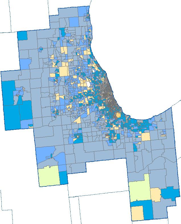
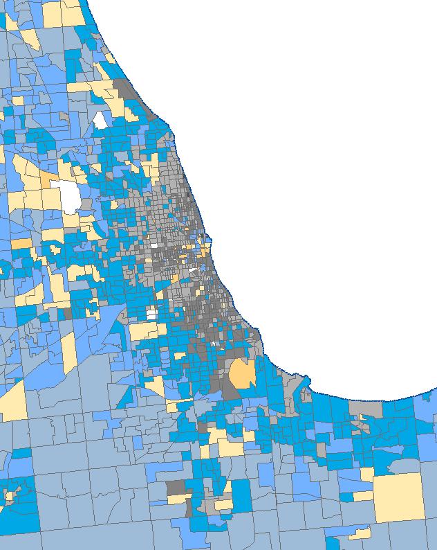
9 Chicago-Naperville-Joliet Suburban Businesses High dense Urban Rural (Farm occup.) 9 Suburbs and the 2010 Census Conference
10 Factor Analysis The causes listed are based on the existing poverty research and each poverty cause is explained by several variables. Sl. No. Poverty Themes 1 Economic Shifts 2 Human Capital 3 Quality of Labor Force 4 Spatial Mismatch 5 Migrations 6 Family Structure 7 Race and Gender Discrimination 8 Endogenous Growth 9 Living Conditions and Affordability 10 Distribution of Public Assistance 10 Suburbs and the 2010 Census Conference
11 Factor Analysis Rotation Factors Factor1 Factor2 Factor3 Factor4 Factor5 Factor Migrations Large families/ Spatial mismatch Family structure/ Affordability Low human capital Racial discrimination Gender discrimination 11 Suburbs and the 2010 Census Conference
12 Multiple Regressions Rural Business Suburban Highly Urban Chow Test Test of Homogeneity F = where as F Critical = 1.83 : implies poverty factors differ across the clusters. 12 Suburbs and the 2010 Census Conference

13 Poverty Causes vs Cluster Types Rural Business Suburban Highly Urban 13 Suburbs and the 2010 Census Conference

14 Poverty Causes.. Consistently important: Family Structure and High Cost of Living Low Human Capital Variably important: Migrations Spatial Mismatch Large family sizes Gender discrimination 14 Suburbs and the 2010 Census Conference
15 Conclusions Cluster analysis A useful technique in identifying different types of neighborhoods Factor analysis Useful in identifying broad correlates of poverty Bringing the above together in a regression framework reveals interesting variation in the role of each factor in explaining poverty 15 Suburbs and the 2010 Census Conference

16 Thank You Any questions? 16 Suburbs and the 2010 Census Conference
Medical GIS: New Uses of Mapping Technology in Public Health. Peter Hayward, PhD Department of Geography SUNY College at Oneonta
 Medical GIS: New Uses of Mapping Technology in Public Health Peter Hayward, PhD Department of Geography SUNY College at Oneonta Invited research seminar presentation at Bassett Healthcare. Cooperstown,
CRP 608 Winter 10 Class presentation February 04, Senior Research Associate Kirwan Institute for the Study of Race and Ethnicity
 CRP 608 Winter 10 Class presentation February 04, 2010 SAMIR GAMBHIR SAMIR GAMBHIR Senior Research Associate Kirwan Institute for the Study of Race and Ethnicity Background Kirwan Institute Our work Using
Gentrification Trends in the United States,
 Gentrification Trends in the United States, 1970-2010 Richard W. Martin, Department of Insurance, Legal, Studies, and Real Estate, Terry College of Business, University of Georgia, 206 Brooks Hall, Athens,
hurricane harvey and equitable recovery
 hurricane harvey and equitable recovery Mapping social vulnerability and intensity of wind and flooding from Hurricane Harvey in Texas hurricane harvey s impact on texas In August 2017, Hurricane Harvey
Online Robustness Appendix to Endogenous Gentrification and Housing Price Dynamics
 Online Robustness Appendix to Endogenous Gentrification and Housing Price Dynamics Robustness Appendix to Endogenous Gentrification and Housing Price Dynamics This robustness appendix provides a variety
C) Discuss two factors that are contributing to the rapid geographical shifts in urbanization on a global scale.
 Discuss two factors that are contributing to the rapid geographical shifts in urbanization on a global scale.") AP Human Geography Unit VII. Cities and Urban Land Use Free Response Questions FRQ 1 Rapid urbanization in Least Developed Countries (LDCs) has many profound impacts for the world. Answer the following
AP Human Geography Unit VII. Cities and Urban Land Use Free Response Questions FRQ 1 Rapid urbanization in Least Developed Countries (LDCs) has many profound impacts for the world. Answer the following
Environmental Analysis, Chapter 4 Consequences, and Mitigation
 Environmental Analysis, Chapter 4 4.17 Environmental Justice This section summarizes the potential impacts described in Chapter 3, Transportation Impacts and Mitigation, and other sections of Chapter 4,
Using American Factfinder
 Using American Factfinder What is American Factfinder? American Factfinder is a search engine that provides access to the population, housing and economic data collected by the U.S. Census Bureau. It can
Ch. 13: Urban Patterns
 Ch. 13: Urban Patterns Name: Introduction & Case Study (p. 430-432) 1. Describe some differences between urban and rural environments. 2. Why do MDCs have a higher percentage of people living in urban
Can Public Transport Infrastructure Relieve Spatial Mismatch?
 Can Public Transport Infrastructure Relieve Spatial Mismatch? Evidence from Recent Light Rail Extensions Kilian Heilmann University of California San Diego April 20, 2015 Motivation Paradox: Even though
Links between socio-economic and ethnic segregation at different spatial scales: a comparison between The Netherlands and Belgium
 Links between socio-economic and ethnic segregation at different spatial scales: a comparison between The Netherlands and Belgium Bart Sleutjes₁ & Rafael Costa₂ ₁ Netherlands Interdisciplinary Demographic
MEASURING RACIAL RESIDENTIAL SEGREGATION
 MEASURING RACIAL RESIDENTIAL SEGREGATION Race Relations Institute Fisk University 1000 Seventeenth Ave. North Nashville, Tennessee 37208 615/329-8575 WHERE WE LIVE: THE COLOR LINE The color line is carved
Demographic Data in ArcGIS. Harry J. Moore IV
 Demographic Data in ArcGIS Harry J. Moore IV Outline What is demographic data? Esri Demographic data - Real world examples with GIS - Redistricting - Emergency Preparedness - Economic Development Next
Neighborhood social characteristics and chronic disease outcomes: does the geographic scale of neighborhood matter? Malia Jones
 Neighborhood social characteristics and chronic disease outcomes: does the geographic scale of neighborhood matter? Malia Jones Prepared for consideration for PAA 2013 Short Abstract Empirical research
Census Transportation Planning Products (CTPP)
") Census Transportation Planning Products (CTPP) Penelope Weinberger CTPP Program Manager - AASHTO September 15, 2010 1 What is the CTPP Program Today? The CTPP is an umbrella program of data products, custom
Census Transportation Planning Products (CTPP) Penelope Weinberger CTPP Program Manager - AASHTO September 15, 2010 1 What is the CTPP Program Today? The CTPP is an umbrella program of data products, custom
A Note on Commutes and the Spatial Mismatch Hypothesis
 Upjohn Institute Working Papers Upjohn Research home page 2000 A Note on Commutes and the Spatial Mismatch Hypothesis Kelly DeRango W.E. Upjohn Institute Upjohn Institute Working Paper No. 00-59 Citation
Research Update: Race and Male Joblessness in Milwaukee: 2008
 Research Update: Race and Male Joblessness in Milwaukee: 2008 by: Marc V. Levine University of Wisconsin Milwaukee Center for Economic Development Briefing Paper September 2009 Overview Over the past decade,
Too Close for Comfort
 Too Close for Comfort Overview South Carolina consists of urban, suburban, and rural communities. Students will utilize maps to label and describe the different land use classifications. Connection to
Spotlight on Population Resources for Geography Teachers. Pat Beeson, Education Services, Australian Bureau of Statistics
 Spotlight on Population Resources for Geography Teachers Pat Beeson, Education Services, Australian Bureau of Statistics Population Population size Distribution Age Structure Ethnic composition Gender
Rural Alabama. Jennifer Zanoni. Geography Division U.S. Census Bureau. Alabama State Data Center 2018 Data Conference Tuscaloosa, Alabama
 Rural Alabama Jennifer Zanoni Geography Division U.S. Census Bureau Alabama State Data Center 2018 Data Conference Tuscaloosa, Alabama May 17, 2018 Agenda Census Geography Urban/Rural Definitions County-based
Follow this and additional works at: Part of the Urban Studies Commons
 The College of Wooster Libraries Open Works Senior Independent Study Theses 2012 Does Spatial Mismatch Still Occur in 2010? An Examination of Race, Income and Urban Georgraphy in the Cleveland-Elyria-Mentor
THE MOST TRANSPARENT TREND in metropolitan areas is the decentralization of jobs and housing into
 AS JOBS SPRAWL, WHITHER THE COMMUTE? BY RANDALL CRANE AND DANIEL G. CHATMAN THE MOST TRANSPARENT TREND in metropolitan areas is the decentralization of jobs and housing into the suburbs and beyond. Scholars
The History Behind Census Geography
 The History Behind Census Geography Michael Ratcliffe Geography Division US Census Bureau Kentucky State Data Center Affiliate Meeting August 5, 2016 Today s Presentation A brief look at the history behind
BROOKINGS May
 Appendix 1. Technical Methodology This study combines detailed data on transit systems, demographics, and employment to determine the accessibility of jobs via transit within and across the country s 100
Urban Studies June 1998 v35 n7 p1187(19) Page 1
 Page 1") Urban Studies June 1998 v35 n7 p1187(19) Page 1 by Katherine M. O Regan and John M. Quigley This paper synthesises a series of empirical analyses investigating the role of urban space in affecting minority
Urban Studies June 1998 v35 n7 p1187(19) Page 1 by Katherine M. O Regan and John M. Quigley This paper synthesises a series of empirical analyses investigating the role of urban space in affecting minority
Changes in Transportation Infrastructure and Commuting Patterns in U.S. Metropolitan Areas,
 Changes in Transportation Infrastructure and Commuting Patterns in U.S. Metropolitan Areas, 1960-2000 Nathaniel Baum-Snow Department of Economics Box B Brown University Providence, RI 02912 Nathaniel_Baum-Snow@brown.edu
Abstract Teenage Employment and the Spatial Isolation of Minority and Poverty Households Using micro data from the US Census, this paper tests the imp
 Teenage Employment and the Spatial Isolation of Minority and Poverty Households by Katherine M. O'Regan Yale School of Management and John M. Quigley University of California Berkeley I II III IV V Introduction
Job Sprawl, Spatial Mismatch, and Black Employment Disadvantage
 Institute for Research on Poverty Discussion Paper no. 1304-05 Job Sprawl, Spatial Mismatch, and Black Employment Disadvantage Michael A. Stoll Department of Public Policy UCLA School of Public Affairs
Explaining Racial/Ethnic Gaps In Spatial Mismatch: The Primacy of Racial Segregation
 National Poverty Center Working Paper Series #10-02 February 2010 Explaining Racial/Ethnic Gaps In Spatial Mismatch: The Primacy of Racial Segregation Michael A. Stoll, UCLA and Kenya L. Covington, California
1Department of Demography and Organization Studies, University of Texas at San Antonio, One UTSA Circle, San Antonio, TX
 Well, it depends on where you're born: A practical application of geographically weighted regression to the study of infant mortality in the U.S. P. Johnelle Sparks and Corey S. Sparks 1 Introduction Infant
Employment Decentralization and Commuting in U.S. Metropolitan Areas. Symposium on the Work of Leon Moses
 Employment Decentralization and Commuting in U.S. Metropolitan Areas Alex Anas Professor of Economics University at Buffalo Symposium on the Work of Leon Moses February 7, 2014 9:30-11:15am, and 2:30-4:30pm
Rural Pennsylvania: Where Is It Anyway? A Compendium of the Definitions of Rural and Rationale for Their Use
 Rural Pennsylvania: Where Is It Anyway? A Compendium of the Definitions of Rural and Rationale for Their Use Pennsylvania Office of Rural Health 310 Nursing Sciences Building University Park, PA 16802
TUESDAYS AT APA PLANNING AND HEALTH. SAGAR SHAH, PhD AMERICAN PLANNING ASSOCIATION SEPTEMBER 2017 DISCUSSING THE ROLE OF FACTORS INFLUENCING HEALTH
 SAGAR SHAH, PhD sshah@planning.org AMERICAN PLANNING ASSOCIATION SEPTEMBER 2017 TUESDAYS AT APA PLANNING AND HEALTH DISCUSSING THE ROLE OF FACTORS INFLUENCING HEALTH Outline of the Presentation PLANNING
During the latter half of the twentieth. Modest Progress:
 Center on Urban & Metropolitan Policy Modest Progress: The Narrowing Spatial Mismatch Between Blacks and Jobs in the 1990s Steven Raphael, University of California, Berkeley Michael A. Stoll, University
Spatial Organization of Data and Data Extraction from Maptitude
 Spatial Organization of Data and Data Extraction from Maptitude N. P. Taliceo Geospatial Information Sciences The University of Texas at Dallas UT Dallas GIS Workshop Richardson, TX March 30 31, 2018 1/
Mapping Communities of Opportunity in New Orleans
 Mapping Communities of Opportunity in New Orleans December 11, 2009 Samir Gambhir Senior Research Associate Kirwan Institute for the study of Race and Ethnicity The Ohio State University Gambhir.2@osu.edu
Key Issue 1: Why Do Services Cluster Downtown?
 Key Issue 1: Why Do Services Cluster Downtown? Pages 460-465 1. Define the term CBD in one word. 2. List four characteristics of a typical CBD. Using your knowledge of services from chapter 12, define
ARIC Manuscript Proposal # PC Reviewed: _9/_25_/06 Status: A Priority: _2 SC Reviewed: _9/_25_/06 Status: A Priority: _2
 ARIC Manuscript Proposal # 1186 PC Reviewed: _9/_25_/06 Status: A Priority: _2 SC Reviewed: _9/_25_/06 Status: A Priority: _2 1.a. Full Title: Comparing Methods of Incorporating Spatial Correlation in
GROWING APART: THE CHANGING FIRM-SIZE WAGE PREMIUM AND ITS INEQUALITY CONSEQUENCES ONLINE APPENDIX
 GROWING APART: THE CHANGING FIRM-SIZE WAGE PREMIUM AND ITS INEQUALITY CONSEQUENCES ONLINE APPENDIX The following document is the online appendix for the paper, Growing Apart: The Changing Firm-Size Wage
Hayward, P. (2007). Mexican-American assimilation in U.S. metropolitan areas. The Pennsylvania Geographer, 45(1), 3-15.
. Mexican-American assimilation in U.S. metropolitan areas. The Pennsylvania Geographer, 45(1), 3-15.") PETER HAYWARD Assistant Professor of Geography and GIS Faculty Fellow SUNY College at Oneonta 323 Milne Library Oneonta, NY 13820 Phone: 607-436-3398 Email: haywarpm@oneonta.edu Web: http://employees.oneonta.edu/haywarpm
PETER HAYWARD Assistant Professor of Geography and GIS Faculty Fellow SUNY College at Oneonta 323 Milne Library Oneonta, NY 13820 Phone: 607-436-3398 Email: haywarpm@oneonta.edu Web: http://employees.oneonta.edu/haywarpm
Explaining Racial/Ethnic Gaps in Spatial Mismatch: The Primacy of Racial Segregation
 Institute for Research on Poverty Discussion Paper no. 1379-10 Explaining Racial/Ethnic Gaps in Spatial Mismatch: The Primacy of Racial Segregation Michael A. Stoll School of Public Affairs University
USING DOWNSCALED POPULATION IN LOCAL DATA GENERATION
 USING DOWNSCALED POPULATION IN LOCAL DATA GENERATION A COUNTRY-LEVEL EXAMINATION CONTENT Research Context and Approach. This part outlines the background to and methodology of the examination of downscaled
The History Behind Census Geography
 The History Behind Census Geography Michael Ratcliffe Geography Division US Census Bureau Tennessee State Data Center August 8, 2017 Today s Presentation A brief look at the history behind some of the
Using the ACS to track the economic performance of U.S. inner cities
 Using the ACS to track the economic performance of U.S. inner cities 2017 ACS Data Users Conference May 11, 2017 Austin Nijhuis, Senior Research Analyst Initiative for a Competitive Inner (ICIC) ICIC ICIC
Victor Valley Community College District
 When beginning a redistricting process, one of the initial steps is to identify the communities of interest. As discussed in our earlier presentation, these can include characteristics of the population
Apéndice 1: Figuras y Tablas del Marco Teórico
 Apéndice 1: Figuras y Tablas del Marco Teórico FIGURA A.1.1 Manufacture poles and manufacture regions Poles: Share of employment in manufacture at least 12% and population of 250,000 or more. Regions:
For much of the past century, the population
 Urban Decentralization and Income Inequality: Is Sprawl Associated with Rising Income Segregation Across Neighborhoods? Christopher H. Existing research shows an inverse relationship between urban density
Geography and Usability of the American Community Survey. Seth Spielman Assistant Professor of Geography University of Colorado
 Geography and Usability of the American Community Survey Seth Spielman Assistant Professor of Geography University of Colorado Goals 1. To convince you that the margins of error from the American Community
Population Profiles
 U N D E R S T A N D I N G A N D E X P L O R I N G D E M O G R A P H I C C H A N G E MAPPING AMERICA S FUTURES, BRIEF 6 2000 2010 Population Profiles Atlanta, Las Vegas, Washington, DC, and Youngstown Allison
PLANNING (PLAN) Planning (PLAN) 1
 Planning (PLAN) 1") Planning (PLAN) 1 PLANNING (PLAN) PLAN 500. Economics for Public Affairs Description: An introduction to basic economic concepts and their application to public affairs and urban planning. Note: Cross-listed
Planning (PLAN) 1 PLANNING (PLAN) PLAN 500. Economics for Public Affairs Description: An introduction to basic economic concepts and their application to public affairs and urban planning. Note: Cross-listed
CRP 272 Introduction To Regression Analysis
 CRP 272 Introduction To Regression Analysis 30 Relationships Among Two Variables: Interpretations One variable is used to explain another variable X Variable Independent Variable Explaining Variable Exogenous
An Indicator Model of the Spatial Quantification and Pattern Analysis of Urban Sustainability: A Case Study of Cincinnati, Ohio
 Current Urban Studies, 2015, 3, 231-240 Published Online September 2015 in SciRes. http://www.scirp.org/journal/cus http://dx.doi.org/10.4236/cus.2015.33019 An Indicator Model of the Spatial Quantification
Chapter 12. Services
 Chapter 12 Services Where di services originate? Key Issue #1 Shoppers in Salzburg, Austria Origins & Types of Services Types of services Consumer services Business services Public services Changes in
Achieving the Vision Geo-statistical integration addressing South Africa s Developmental Agenda. geospatial + statistics. The Data Revolution
 Achieving the Vision Geo-statistical integration addressing South Africa s Developmental Agenda geospatial + statistics The Data Revolution humble beginnings, present & future - South Africa UN World Data
Graduate Course Descriptions Spring 2016
 DOCTORAL MASTER S BACHELOR S CERTIFICATE Graduate Course Descriptions Spring 2016 Urban Studies office in Bolton 702 (414) 229-4751 http://www.urbanstudies.uwm.edu URB STD 913 Graduate Courses Seminar
Chapter 9: Urban Geography
 Chapter 9: Urban Geography The Five Steps to Chapter Success Step 1: Read the Chapter Summary below, preview the Key Questions, and Geographic Concepts. Step 2: Complete the Pre-Reading Activity (PRA)
Key Issue 1: Why Do Services Cluster Downtown?
 Key Issue 1: Why Do Services Cluster Downtown? Pages 460-465 ***Always keep your key term packet out whenever you take notes from Rubenstein. As the terms come up in the text, think through the significance
MULTIPLE CHOICE. Choose the one alternative that best completes the statement or answers the question.
 AP Test 13 Review Name MULTIPLE CHOICE. Choose the one alternative that best completes the statement or answers the question. 1) Compared to the United States, poor families in European cities are more
Labor Market Polarization and a Changing Recovery in the Chicago Metropolitan Area
 Labor Market Polarization and a Changing Recovery in the Chicago Metropolitan Area Executive Summary High-Wage Middle-Wage Low-Wage Exhibit 1: Change in Total Jobs by Wage Tier (2006-2015) -3.0% 0.0% 2.5%
This report details analyses and methodologies used to examine and visualize the spatial and nonspatial
 Analysis Summary: Acute Myocardial Infarction and Social Determinants of Health Acute Myocardial Infarction Study Summary March 2014 Project Summary :: Purpose This report details analyses and methodologies
DEVELOPING DECISION SUPPORT TOOLS FOR THE IMPLEMENTATION OF BICYCLE AND PEDESTRIAN SAFETY STRATEGIES
 DEVELOPING DECISION SUPPORT TOOLS FOR THE IMPLEMENTATION OF BICYCLE AND PEDESTRIAN SAFETY STRATEGIES Deo Chimba, PhD., P.E., PTOE Associate Professor Civil Engineering Department Tennessee State University
Demographic Data. How to get it and how to use it (with caution) By Amber Keller
 By Amber Keller") Demographic Data How to get it and how to use it (with caution) By Amber Keller 101 Where does it come from? o The American Community Survey o Socio-economic characteristics of a population o Administered
Demographic Data How to get it and how to use it (with caution) By Amber Keller 101 Where does it come from? o The American Community Survey o Socio-economic characteristics of a population o Administered
Long Commutes or Neighborhood Perceptions: Why Do Employers Avoid Applicants from High-Poverty Neighborhoods?
 Long Commutes or Neighborhood Perceptions: Why Do Employers Avoid Applicants from High-Poverty Neighborhoods? David C. Phillips Assistant Professor of Economics Hope College Abstract Why do employers discriminate
BIG IDEAS. Area of Learning: SOCIAL STUDIES Urban Studies Grade 12. Learning Standards. Curricular Competencies
 Area of Learning: SOCIAL STUDIES Urban Studies Grade 12 BIG IDEAS Urbanization is a critical force that shapes both human life and the planet. The historical development of cities has been shaped by geographic,
An Introduction to China and US Map Library. Shuming Bao Spatial Data Center & China Data Center University of Michigan
 An Introduction to China and US Map Library Shuming Bao Spatial Data Center & China Data Center University of Michigan Current Spatial Data Services http://chinadataonline.org China Geo-Explorer http://chinageoexplorer.org
Developing Spatial Data to Support Statistical Analysis of Education
 Developing Spatial Data to Support Statistical Analysis of Education Doug Geverdt National Center for Education Statistics Education Demographic and Geographic Estimates (EDGE) Program 2016 ESRI User Conference
Census Urban Area Comparisons, 2000 to 2010
 THE HONORABLE ROGERS Mayor ANDERSON, Karl Dean, CHAIRMAN Chairman Census Urban Area Comparisons, 2000 to 2010 TCC May 2, 2012 MPOs/RPOs in Tennessee Regional Geographies in Middle TN Nashville MPO Clarksville
Are You Maximizing The Value Of All Your Data?
 Are You Maximizing The Value Of All Your Data? Using The SAS Bridge for ESRI With ArcGIS Business Analyst In A Retail Market Analysis SAS and ESRI: Bringing GIS Mapping and SAS Data Together Presented
Jun Tu. Department of Geography and Anthropology Kennesaw State University
 Examining Spatially Varying Relationships between Preterm Births and Ambient Air Pollution in Georgia using Geographically Weighted Logistic Regression Jun Tu Department of Geography and Anthropology Kennesaw
Internal migration patterns in the EU and the future population development of large cities in Germany
 Internal migration patterns in the EU and the future population development of large cities in Germany Prof. Dr. Paul Gans Chair of Economic Geography Department of Economics University of Mannheim D-68131
Does city structure cause unemployment?
 The World Bank Urban Research Symposium, December 15-17, 2003 Does city structure cause unemployment? The case study of Cape Town Presented by Harris Selod (INRA and CREST, France) Co-authored with Sandrine
SPATIAL ANALYSIS OF POPULATION DATA BASED ON GEOGRAPHIC INFORMATION SYSTEM
 SPATIAL ANALYSIS OF POPULATION DATA BASED ON GEOGRAPHIC INFORMATION SYSTEM Liu, D. Chinese Academy of Surveying and Mapping, 16 Beitaiping Road, Beijing 100039, China. E-mail: liudq@casm.ac.cn ABSTRACT
The impact of residential density on vehicle usage and fuel consumption*
 The impact of residential density on vehicle usage and fuel consumption* Jinwon Kim and David Brownstone Dept. of Economics 3151 SSPA University of California Irvine, CA 92697-5100 Email: dbrownst@uci.edu
Tracey Farrigan Research Geographer USDA-Economic Research Service
 Rural Poverty Symposium Federal Reserve Bank of Atlanta December 2-3, 2013 Tracey Farrigan Research Geographer USDA-Economic Research Service Justification Increasing demand for sub-county analysis Policy
The Impact of Residential Density on Vehicle Usage and Fuel Consumption: Evidence from National Samples
 The Impact of Residential Density on Vehicle Usage and Fuel Consumption: Evidence from National Samples Jinwon Kim Department of Transport, Technical University of Denmark and David Brownstone 1 Department
Are Travel Demand Forecasting Models Biased because of Uncorrected Spatial Autocorrelation? Frank Goetzke RESEARCH PAPER
 Are Travel Demand Forecasting Models Biased because of Uncorrected Spatial Autocorrelation? By Frank Goetzke RESEARCH PAPER 2003-10 Graduate Research Assistant Department of Economics College of Business
INTRODUCTION SEGREGATION AND NEIGHBORHOOD CHANGE: WHERE ARE WE AFTER MORE THAN A HALF-CENTURY OF FORMAL ANALYSIS 1
 INTRODUCTION SEGREGATION AND NEIGHBORHOOD CHANGE: WHERE ARE WE AFTER MORE THAN A HALF-CENTURY OF FORMAL ANALYSIS 1 David W. Wong 2 Department of Earth Systems and GeoInformation Sciences George Mason University
DRAFT RURAL-URBAN POPULATION CHANGE IN PUERTO RICO, 1990 TO 2000
 DRAFT RURAL-URBAN POPULATION CHANGE IN PUERTO RICO, 1990 TO 2000 Mei-Ling Freeman Geographic Standards and Criteria Branch Geography Division US Census Bureau For presentation at the Western Regional Science
Topic 4: Changing cities
 Topic 4: Changing cities Overview of urban patterns and processes 4.1 Urbanisation is a global process a. Contrasting trends in urbanisation over the last 50 years in different parts of the world (developed,
Urbanization Inside the City 2
 DATES TO REMEMBER COURSE EVALUATION PERIOD OPEN to Dec. 20. Sign in with your Hunter NetID and password Check your Hunter email account for notice from the Dean of Students. TODAY, Mon., Dec 12: Last class
LOCAL GOVERNMENT ADMINISTRATION SERIES
 Public Policy Research Center University of Missouri St. Louis LOCAL GOVERNMENT ADMINISTRATION SERIES ISSUE #3 MARCH 2017 THE GOVERNOR IN GOVERNANCE: KEEPING THE PACE by Mark Tranel, Director, Public Policy
Urban Revival in America
 Urban Revival in America Victor Couture 1 Jessie Handbury 2 1 University of California, Berkeley 2 University of Pennsylvania and NBER May 2016 1 / 23 Objectives 1. Document the recent revival of America
US Census Bureau Geographic Entities and Concepts. Geography Division
 US Census Bureau Geographic Entities and Concepts Geography Division Geographic Concepts Addresses vs. Geographic features and entities Legal/Administrative vs. Statistical Nesting relationships (or the
Urbanization 5/17/2002 1
 Urbanization Study of processes of urbanization in sociology is called urban sociology. Urbanization is the process of increase in the percentage of a population living in cities. A city is a densely settled
IMPACTS OF SPATIAL MISMATCH ON COMMUTING TIME OF URBAN RESIDENTS IN CHINA
 DANWEN BAO E-mail: baodanwen_sci@163.com College of Civil Aviation Nanjing University of Aeronautics and Astronautics Nanjing 210016, China TANGYI GUO E-mail: guotangyi_sci@163.com School of Automation
c. What is the most distinctive above ground result of high land costs and intensive land use? i. Describe the vertical geography of a skyscraper?
 AP Human Geography Unit 7b Guided Reading: Urban Patterns and Social Issues Mr. Stepek Key Issue #1: Why Do Services Cluster Downtown? (Rubenstein p 404 410) 1. What is the CBD? What does it contain and
Arkansas Retiree In-Migration: A Regional Analysis
 Community & Economic Development FSCDM5 Arkansas Retiree In-Migration: A Regional Analysis Wayne Miller Professor and Extension Economist Katy Elliott Extension Associate - Community and Economic Development
Summary Article: Poverty from Encyclopedia of Geography
 Topic Page: Poverty Definition: poverty from Dictionary of Energy Social Issues. the fact of being poor; the absence of wealth. A term with a wide range of interpretations depending on which markers of
Transit as Solution for Spatial Mismatch
 Transit as Solution for Spatial Mismatch Tianran Zeng Georgia Institute of Technology Abstract From the late 1980s, as the trend of suburbanization and welfare reform draw researchers and policymaker s
DIFFERENT INFLUENCES OF SOCIOECONOMIC FACTORS ON THE HUNTING AND FISHING LICENSE SALES IN COOK COUNTY, IL
 DIFFERENT INFLUENCES OF SOCIOECONOMIC FACTORS ON THE HUNTING AND FISHING LICENSE SALES IN COOK COUNTY, IL Xiaohan Zhang and Craig Miller Illinois Natural History Survey University of Illinois at Urbana
Analysis of travel-to-work patterns and the identification and classification of REDZs
 Analysis of travel-to-work patterns and the identification and classification of REDZs Dr David Meredith, Teagasc, Spatial Analysis Unit, Rural Economy Development Programme, Ashtown, Dublin 15. david.meredith@teagasc.ie
2/25/2019. Taking the northern and southern hemispheres together, on average the world s population lives 24 degrees from the equator.
 Where is the world s population? Roughly 88 percent of the world s population lives in the Northern Hemisphere, with about half north of 27 degrees north Taking the northern and southern hemispheres together,
Sidestepping the box: Designing a supplemental poverty indicator for school neighborhoods
 Sidestepping the box: Designing a supplemental poverty indicator for school neighborhoods Doug Geverdt National Center for Education Statistics Laura Nixon U.S. Census Bureau 2018 Annual meeting of the
Maggie M. Kovach. Department of Geography University of North Carolina at Chapel Hill
 Maggie M. Kovach Department of Geography University of North Carolina at Chapel Hill Rationale What is heat-related illness? Why is it important? Who is at risk for heat-related illness and death? Urban
NEW YORK AND CONNECTICUT SUSTAINABLE COMMUNITIES. Fair Housing & Equity Assessment & Regional Planning Enhancement
 NEW YORK AND CONNECTICUT SUSTAINABLE COMMUNITIES Fair Housing & Equity Assessment & Regional Planning Enhancement November 19, 2013 White Plains Public Library Federal grant to improve regional planning
Working Paper UCTC No. 290
 Teenage Employment and the Spatial Isolation of Minority and Poverty Households Katherine M. O Regan John M. Quigley Working Paper UCTC No. 290 The Umversity of California Transportation Center University
Evaluating Community Analyst for Use in School Demography Studies
 Portland State University PDXScholar Publications, Reports and Presentations Population Research Center 7-2013 Evaluating Community Analyst for Use in School Demography Studies Richard Lycan Portland State
Introduction and Project Overview
 Greater New Orleans Regional Land Use Modeling GIS Techniques in a P olitical C ontext Louisiana Remote Sensing and GIS Workshop Wednesday, April 24, 2013 Working Towards a Shared Regional Vision Introduction
Geospatial Analysis of Job-Housing Mismatch Using ArcGIS and Python
 Geospatial Analysis of Job-Housing Mismatch Using ArcGIS and Python 2016 ESRI User Conference June 29, 2016 San Diego, CA Jung Seo, Frank Wen, Simon Choi and Tom Vo, Research & Analysis Southern California
Curriculum Unit. Instructional Unit #1
 Curriculum Unit Name of Course: AP Human Geography Grade Level(s): 9-12 Brief Description (Course Catalog): The purpose of the AP Human Geography course is to introduce students to the systematic study