Priority Conservation Areas: Baja California to Bering Sea
|
|
|
- Cody Wood
- 5 years ago
- Views:
Transcription


1 Priority Conservation Areas: Baja California to Bering Sea Lance Morgan, Chief Scientist Marine Conservation Biology Institute

2 Goal : Identify Unique Places
3 How do you start conservation planning for an area 4.8x10 6 km 2? Define the question what is a priority conservation area? Develop a methodology Determine data needs Gather and compile baseline data in a Geographic Information System (GIS) Analyze data and use expert knowledge to address question Identify priority areas consensus mapping workshop
4 What is a Priority Conservation Area? Area with high: ecological value anthropogenic threat conservation opportunity
5 Ground Rules: 1. Work with ongoing MPA initiatives 2. Try to us common data sets across regions 3. Establish a hierarchical GIS framework for regional initiatives
6 Population Targets Scale sq km: metapopulation, larval dispersal, home range, migration corridors, feeding areas, nesting areas, concentration areas Scale sq km: sub-population, migration routes, species range, larval dispersal
7 Physiographic Targets Scale sq km: basins, banks, bays, calderas, canyons, estuaries, seamounts, hills, headlands, ridges, terraces, troughs Scale sq km: Island archipelagos, ridges, seamounts, trenches
8 Oceanographic Targets Scale sq km: turbulence (island wakes, headland eddies), estuarine circulation, tides, river plumes, coastal currents, internal waves, upwelling jets, coastal retention zones, fronts Scale sq km: mesoscale circulation, fronts, eddies, river plumes

9 Threats and Opportunities Threats exploitation, extraction, coastal land-use, pollution, coastline alteration, recreation Opportunities previous priority setting, sustainable development and management, opportunity for local or regional engagement, funding vehicles

10 Available data B2B 1.1 Biological Physical Social Chl a turtle whale bathy ssh sst pop mpa port Biological data chlorophyll A/ cold corals/ whales/ turtles/ Physical data shoreline/ bathymetry/ currents/ temperature/ seamounts/ Social data EEZ/ population/ fishing ports/ local priorities/ mpa/

11 Marine Species of Common Conservation Concern E. Pacific green turtle Hawksbill turtle Kemp's Ridley turtle Leatherback turtle Loggerhead Turtle Pink-footed shearwater Short-tailed tailed albatross Xantus' murrelet Humpback whale Blue whale Killer whale Gray whale Right whale Guadalupe fur seal Sea otter Vaquita

12 Courtesy of Glenn Ford, Ecological Consulting, Inc. Portland, Oregon

13
14 Data Analysis Seamount density Benthic Features


15 At the B2B scale Bathymetry: ETOPO2, regions of higher resolution Density of Seamounts: 250 km search radius
16 Data Analyses Sea surface temperature Sea surface height (altimetry) Primary production Pelagic Features

17 Blue Whales Tracks and SST Fronts Blue whale tracks courtesy of Bruce Mate, OSU
18 Consensus Mapper computers networked with GIS Common Visual Display Experts Computer Network GIS software GIS facilitator Workshop facilitator Common Display Workshop Facilitator Networked Computer System GIS Facilitator Computer Terminals Canadian, Mexican and US Experts
19 Consensus Mapper Process expert group 1 expert group n Priority areas chosen by experts GIS map intersection Common area of agreement to initiate discussion Discussion and verification

20 Bahia Magdalena Magdalena Bay
")
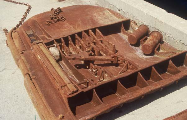
21 High ecological significance (e.g., seamounts, endemic vaquita,, seabird concentration) Anthropogenic threats (e.g., fishing, marine tourism, habitat loss) Conservation opportunities (e.g., grassroots support, marine protected areas)


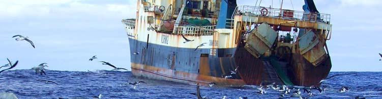
22 PCA 3. Western Aleutians


23 PCA 11. QCI /Hecate St./ Gwaii Hanas


24 PCA 16. Central California


25 PCA 20. Guadalupe Island
26 Panel Questions 1. Both MPAs and ecosystem-based management (EBM) represent place- based approaches to achieving marine conservation goals. Given that fundamental overlap in approach, how do MPAs fit within the larger context of ecosystem based management? 2. Are there differences in the science needs (both natural and social) for MPAs vs. EAM/EBM, and if so, which are uniquely required by MPAs? 3. What lessons can we learn from the design and implementation of MPAs and an effective national system of MPAs that will inform our efforts to implement EAM on regional scales?

27


28


29 Healthy and Trawled Oculina coral reefs (Florida, USA)
 and NRC (2002)")
30 There are solutions: Freeze the footprint Reduce effort Protect areas Use less destructive gear ICES (2000) and NRC (2002) recommendations


31 Shifting Gears Review of different fishing methods found different gears have different environmental impacts we can manage for these impacts. Morgan and Chuenpagdee 2003
32 100 Relative Gear Rankings Relative severity 50 Bottom trawl Bottom gillnet Dredge Midwater gillnet HIGH- IMPACT Pots & Traps Pelagic longline Bottom longline MEDIUM- IMPACT 0 Midwater trawl, Hook { & Line, Purse seine LOW- IMPACT
33 FEP considerations-epap 1999 (1) delineate the geographic extent of ecosystems; (2) develop a conceptual model of the food web; (3) describe habitat needs of different food web components; (4) calculate total removals and relate them to standing biomass, production, optimum yield, natural mortality and trophic structure to ensure that they are not excessive; (5) assess uncertainty and how buffers are included in conservation and management actions; (6) develop indices of ecosystem health as targets; (7) describe long term monitoring and how it is used; (8) identify external elements to management that affect fisheries and their ecosystems and reduce these impacts.
34 But fishing is not the only human activity we seek to manage More broadly an ecosystem approach to management should be a holistic view of all human activities with the goal of maintaining functioning ecosystems, healthy populations and extracting resources in a sustainable manner


35

36


37 Energy Production

38 Zoning A place-based ecosystem management system that reduces conflict, uncertainty and costs by separating incompatible uses and specifying how particular areas may be used
39 A Simple Zoning System No-go zones (e.g., seabird nesting colonies) so sensitive that humans (except permitted researchers) are prohibited (very limited) Marine reserves that protect biodiversity by prohibiting all extractive and other harmful uses Buffer zones that surround or adjoin no-go and marine reserve zones and allow extractive uses that do not degrade habitats e.g., no mobile bottom tending fishing gear General use zones that allow a wide range of activities (probably a plurality of the area)

40

41

42 U.S. Sanctuaries are multiple use zoning opportunities

43 Acknowledgements Commission for Environmental Cooperation David and Lucile Packard Foundation and J.M. Kaplan Fund NOAA MPA Science Center Advisors and workshop participants B2B Initiative steering committee members John Guinotte, Peter Etnoyer, Dave Canny, Fan Tsao, Sara Maxwell, Elliott Norse, Dan Pauly Simon Fraser University, Pat Gallaugher,, Suzana Dragicevic,, Thom Meredith and the McGill University team. B2B cdrom data providers Photo Credits: Sabine Jessen, Phillip Colla, Randall Davis, Andrew Lindner, Cordell Expeditions, National Marine Mammal Laboratory, Grupo de Ecologia y Conservacion de Islas, Mike Conti, NOAA
IDENTIFYING PRIORITY CONSERVATION AREAS FROM BAJA CALIFORNIA TO THE BERING SEA
 IDENTIFYING PRIORITY CONSERVATION AREAS FROM BAJA CALIFORNIA TO THE BERING SEA Lance Morgan 1, Peter Etnoyer 2, Tara Wilkinson 3, Hans Herrmann 3, Fan Tsao 1 and Sara Maxwell 1 1 Marine Conservation Biology
Lesson 3: Protecting Ocean Hotspots
 Lesson 3: Protecting Ocean Hotspots Name: Date: Engage Think about the ocean and the seafloor. 1. Draw a sketch of what you picture when you think about the seafloor. Explore 2. When your teacher projects
Marine Spatial Planning: A Tool for Implementing Ecosystem-Based Management
 Marine Spatial Planning: A Tool for Implementing Ecosystem-Based Management Steven Murawski, Ph.D., Ecosystem Goal Team Lead National Oceanic and Atmospheric Administration NOAA November 16, 2009 1 To
Physiography Ocean Provinces p. 1 Dimensions p. 1 Physiographic Provinces p. 2 Continental Margin Province p. 2 Deep-Ocean Basin Province p.
 Physiography Ocean Provinces p. 1 Dimensions p. 1 Physiographic Provinces p. 2 Continental Margin Province p. 2 Deep-Ocean Basin Province p. 2 Mid-Ocean Ridge Province p. 3 Benthic and Pelagic Provinces
Introduction: The Gulf of Mexico Alliance. The Gulf GAME project MERMAid and PHINS Results & Conclusions What s next? Examples
 AAG Las Vegas March 25, 2009 Introduction: Ocean governance and Ecosystem-Based Management The Gulf of Mexico Alliance Habitat Identification and Characterization The Gulf GAME project MERMAid and PHINS
Outline. - Background of coastal and marine conservation - Species distribution modeling (SDM) - Reserve selection analysis. - Results & discussion
 - Reserve selection analysis. - Results & discussion") Application of GIS for data preparation and modeling for coastal and marine conservation planning in Madagascar Rija Rajaonson Technical Assistant, REBIOMA Wildlife Conservation Society Madagascar Outline
Application of GIS for data preparation and modeling for coastal and marine conservation planning in Madagascar Rija Rajaonson Technical Assistant, REBIOMA Wildlife Conservation Society Madagascar Outline
NOAA s OCM: Services, tools and collaboration opportunities & Puerto Rico s NE Marine Corridor as a case study
 NOAA s OCM: Services, tools and collaboration opportunities & Puerto Rico s NE Marine Corridor as a case study Dr. Antares Ramos Álvarez NOAA s Office of Coastal Management September 15 th, 2016 Conservation
Aggregation Hotspots
 Photo: Mike Brittain Aggregation Hotspots George L. Hunt, Jr. School of Aquatic and Fishery Sciences University of Washington What is a Hotspot? Original focus- Regions of exceptional terrestrial biodiversity
Biogeographic Approach to Coastal Assessments & Spatial Planning
 NOAA s Biogeographic Approach to Coastal Assessments & Spatial Planning Mark E. Monaco Mark.Monaco@noaa.gov Center for Coastal Monitoring and Assessment http://ccma.nos.noaa.gov/about/biogeography Biogeography
9.0 Consistency with the Magnuson-Stevens Fishery Conservation and Management Act (MSFCMA)
") 9.0 Consistency with the Magnuson-Stevens Fishery Conservation and Management Act (MSFCMA) This analysis was prepared in accordance with the requirements of the Magnuson- Stevens Fishery Conservation and
9.0 Consistency with the Magnuson-Stevens Fishery Conservation and Management Act (MSFCMA) This analysis was prepared in accordance with the requirements of the Magnuson- Stevens Fishery Conservation and
2012 FORUM OF MARINE PROTECTED AREAS IN THE MEDITERRANEAN ANTALYA, TURKEY
 2012 FORUM OF MARINE PROTECTED AREAS IN THE MEDITERRANEAN ANTALYA, TURKEY SPECIAL EVENT Challenges for Open Seas MPAs in the Mediterranean region November 27, 2012. 15h00-16H00 Slide # 1 2012 FORUM OF
Marine Geomorphology as a Determinant for Essential Life Habitat III
 Marine Geomorphology as a Determinant for Essential Life Habitat III marinecoastalgis.net/aag08 10:10 Dawn Wright, Oregon 10:30 Will McClintock, California 10:50 Daniel Sampson, Massachusetts 11:10 Gary
Socioeconomic Profile and Spatial Analysis of Fisheries in the three central California National Marine Sanctuaries
 Socioeconomic Profile and Spatial Analysis of Fisheries in the three central California National Marine Sanctuaries 23 + 30 March 2004 Charles Steinback and Astrid Scholz Outline Who we are and why we
Assessing, Monitoring, and Defending Coral Reefs with GIS
 Assessing, Monitoring, and Defending Coral Reefs with GIS Dr. Rich Snow and Dr. Mary Snow Applied Aviation Sciences Embry-Riddle Aeronautical University Daytona Beach, Florida It is estimated that 60%
Ocean fronts as an indicator of marine animals: expediting site selection and survey for offshore renewables
 Ocean fronts as an indicator of marine animals: expediting site selection and survey for offshore renewables Peter Miller and David Sims 1 1 MBA Oceanic fronts for pelagic diversity Detecting ocean fronts
MPAs - do we need them?
 MPAs - do we need them? Thomas Peschak We all want healthy oceans We all want healthy oceans Our Natural Heritage conserved for future generations We all want healthy oceans To enjoy our sea and the economic
Cross-border Maritime Spatial Plan for the Black sea - Romania and Bulgaria project
 Cross-border Maritime Spatial Plan for the Black sea - Romania and Bulgaria project in Romania and Bulgaria Plan Presentation A first step in the management of the marine areas of Romania and Bulgaria
SW Florida Escarpment Mapping Area
 Overview NOAA s Okeanos Explorer (EX) Program plans to conduct systematic mapping and telepresence-enabled ROV explorations in the Gulf of Mexico during Spring 2014. In 2011, the EX conducted mapping operations
Spatial Planning in Canada s Maritimes Region. Maritimes Region
 Spatial Planning in Canada s Maritimes Region Glen Herbert, Scott Coffen-Smout Smout,, and Tanya Koropatnick Oceans and Coastal Management Division Ecosystem Management Branch Fisheries and Oceans Canada
Designing Networks of Marine Protected Areas in DFO s Three Atlantic Bioregions
 Designing Networks of Marine Protected Areas in DFO s Three Atlantic Bioregions Presentation for Indigenous Protected Areas Workshop Max Westhead, DFO and Adrian Gerhartz-Abraham, Dalhousie March 29, 2017
MEMORANDUM OF UNDERSTANDING ON THE CONSERVATION OF MIGRATORY SHARKS HABITAT CONSERVATION. (Prepared by the Advisory Committee)
") MEMORANDUM OF UNDERSTANDING ON THE CONSERVATION OF MIGRATORY SHARKS CMS/Sharks/MOS3/Doc.10.2 24 August 2018 Original: English 3 rd Meeting of the Signatories (Sharks MOS3) Monaco, 10 14 December 2018 Agenda
MEMORANDUM OF UNDERSTANDING ON THE CONSERVATION OF MIGRATORY SHARKS CMS/Sharks/MOS3/Doc.10.2 24 August 2018 Original: English 3 rd Meeting of the Signatories (Sharks MOS3) Monaco, 10 14 December 2018 Agenda
NOAA Applications of OC data
 NOAA Applications of OC data Cara Wilson NOAA/NMFS/SWFSC/ERD 2017 IOCS Meeting, Lisbon, Portugal, May 16 NOAA poster presentations 2017 IOCS Meeting Name Foster et al. Hyde et al. Lance et al. Liu & Wang
WELCOME & INTRODUCTION
 MPA Management Capacity Building Training Module 1: WELCOME & INTRODUCTION Participants Distinguished Guests Welcome Site Overviews of MPAs represented Overview of Training Program What are Today s Objectives?
Developing a Regulatory Framework for the Deep Sea Mineral Exploitation.
 Developing a Regulatory Framework for the Deep Sea Mineral Exploitation. Stakeholder Survey Submission to the United National International Seabed Authority (UN ISA). Benjamin Kahn 1 May 2014 1 Director
Marine ecosystem mapping at the Prince Edward Islands
 Marine ecosystem mapping at the Prince Edward Islands Biodiversity Planning Forum NBA special session June 2018 R Adams, C von der Meden, A Dayaram, K Sink, A Lombard, A Bosman, M Dopolo, F Fourie, L Harris,
Multi-sector biodiversity surveys: integrating federal, territorial and community-based surveys. Kevin J. Hedges
 Multi-sector biodiversity surveys: integrating federal, territorial and community-based surveys Kevin J. Hedges Outline Study area Research/stakeholder groups Recent integration Eastern Canadian Arctic
Protecting the ocean s final frontiers the high seas and deep ocean. Callum Roberts University of York
 Protecting the ocean s final frontiers the high seas and deep ocean Callum Roberts University of York The high seas = 61% of the oceans and 43% of the surface of the Earth Courtesy of NASA Goddard Space
Agenda Item F.4.c Supplemental Public Comment 3 November 2016
 Agenda Item F.4.c Supplemental Public Comment 3 November 2016 Stand up for California's seafloor A starfish, coral and a green spotted rockfish. (Photo Courtesy of Oceana) Available at: http://fw.to/04jcx6y
HAB Forecaster. For info on HABs in the Pacific Northwest see:
 HAB Forecaster BACKGROUND In this activity, students can take on the role as a resource manager or scientist, tasked with deciding if razor clam harvesters should go out onto the beach to harvest razor
Courtesy of John Mitchell
 Shrimp trawl fisheries Marine fish stocks are under increasing threat from a range of spatially based problems that might be natural or involve socio-economic factors. To best manage spatial problems,
Movements of striped bass in response to extreme weather events
 Movements of striped bass in response to extreme weather events Helen Bailey and David Secor E-mail: hbailey@umces.edu 1 Background 2 Outline What is movement ecology? Methods for analyzing animal tracks
Sister Sanctuaries: Linking the Science and Management of Coral Reefs in Cuba and the U.S.
 Sister Sanctuaries: Linking the Science and Management of Coral Reefs in Cuba and the U.S. Memorandum of Understanding on Cooperation in the Conservation and Management of Marine Protected Areas Seventh
TOWARDS CLIMATE-RESILIENT COASTAL MANAGEMENT: OPPORTUNITIES FOR IMPROVED ICZM IN BELIZE
 TOWARDS CLIMATE-RESILIENT COASTAL MANAGEMENT: OPPORTUNITIES FOR IMPROVED ICZM IN BELIZE CHANTALLE SAMUELS Coastal Zone Management Authority and Institute The Caribbean Community Climate Change Centre VULNERABILITY
CONSERVATION MEASURE (2016) Ross Sea region marine protected area. The Commission,
 Ross Sea region marine protected area. The Commission,") CONSERVATION MEASURE 91-05 (2016) Ross Sea region marine protected area Species all Area 88.1 and 882A B Season all (commencing 1 December 2017) Gear all The Commission, Desiring to implement Articles
CONSERVATION MEASURE 91-05 (2016) Ross Sea region marine protected area Species all Area 88.1 and 882A B Season all (commencing 1 December 2017) Gear all The Commission, Desiring to implement Articles
A TOOLKIT FOR MARINE SPATIAL PLANNING Version: 17 July, 2009
 A TOOLKIT FOR MARINE SPATIAL PLANNING Version: 17 July, 2009 NEED FOR MARINE SPATIAL PLANNING The health of marine ecosystems is declining, and use conflicts in the marine environment are increasing, in
Modeling dispersal kernals with limited. information. Douglas T. Fischer, Louis W. Botsford, David M. Kaplan, J. William White, John Largier
 Modeling dispersal kernals with limited http://www.nmfs.noaa.gov/habitat/ habitatprotection/profile/pacificcouncil.htm information Douglas T. Fischer, Louis W. Botsford, David M. Kaplan, J. William White,
Aggregation Hotspots
 Photo: Mike Brittain Aggregation Hotspots George L. Hunt, Jr. School of Aquatic and Fishery Sciences University of Washington Aggregation Hotspots Predictable in Time and Space Places with high rates of
PRIORITY TWO-YEAR ACTIVITIES ( ) PRIORITY ONE: INTERNATIONAL RECOGNITION OF ECOLOGICAL IMPORTANCE
 PRIORITY ONE: INTERNATIONAL RECOGNITION OF ECOLOGICAL IMPORTANCE") PREFACE: The Work Programme goals and priority activities were developed at the Second Joint Meeting of the Signatories to the Hamilton Declaration and the Sargasso Sea Commission, held in Key West Florida,
PREFACE: The Work Programme goals and priority activities were developed at the Second Joint Meeting of the Signatories to the Hamilton Declaration and the Sargasso Sea Commission, held in Key West Florida,
PRINCIPLE OF OCEANOGRAPHY PBBT101 UNIT-1 INTRODUCTION OF OCEANIC ENVIRONMENT. PART-A (2 Marks)
") PRINCIPLE OF OCEANOGRAPHY PBBT101 UNIT-1 INTRODUCTION OF OCEANIC ENVIRONMENT 1. Define marine ecosystem. 2. What is geography? 3. Give two Oceanic zones 4. What is sea? 5. Define oceanography? 6. Enlist
PRINCIPLE OF OCEANOGRAPHY PBBT101 UNIT-1 INTRODUCTION OF OCEANIC ENVIRONMENT 1. Define marine ecosystem. 2. What is geography? 3. Give two Oceanic zones 4. What is sea? 5. Define oceanography? 6. Enlist
National Marine Sanctuary Program
 National Marine Sanctuary Program NMSP/USGS Joint Seabed Mapping Initiative: September 2004 AA National Ocean Service National Marine Sanctuaries Interim Report September 2004 Background: Since 2002,
MARINE SPATIAL PLANNING
 MARINE SPATIAL PLANNING Washington Uses Spatial Planning to Honor its Pacific Coast and Offshore Waters Past, Present and Future The Washington State Pacific Coast and offshore waters are diverse in both
The IUCN Facilitated Independent Advisory Panel on Remediation and Rehabilitation of Biodiversity and Habitats of Oil Spill Sites in the Niger Delta
 World Conservation Congress, Jeju, Korea, September 2012 The IUCN Facilitated Independent Advisory Panel on Remediation and Rehabilitation of Biodiversity and Habitats of Oil Spill Sites in the Niger Delta
BIOLOGICAL OCEANOGRAPHY
 BIOLOGICAL OCEANOGRAPHY AN INTRODUCTION 0 ^ J ty - y\ 2 S CAROL M. LALLI and TIMOTHY R. PARSONS University of British Columbia, Vancouver, Canada PERGAMON PRESS OXFORD NEW YORK SEOUL TOKYO ABOUT THIS VOLUME
EUSAIR on sea topics from Slovenian perspective
 MINISTRY OF FOREIGN AFFAIRS REPUBLIC OF SLOVENIA EUSAIR on sea topics from Slovenian perspective Mag. Andreja Jerina National Coordinator 4 EU MRS: 270 millions of population 19 MS 12 non MS Sea basin
6 th Meeting of the Scientific Committee Puerto Varas, Chile, 9-14 September 2018
 6 th Meeting of the Scientific Committee Puerto Varas, Chile, 9-14 September 2018 SC6-DW11 Methods for designing spatial management areas using outputs from Zonation software and other spatial data Martin
NOAA S Arctic Program in 2017
 NOAA S Arctic Program in 2017 NOAA s Arctic Mission To determine how the Arctic system is changing on time scales of weeks to decades, particularly with respect to the consequences that the loss of sea
CLIMAR-III Third JCOMM Workshop on Advances in Marine Climatology 6-9 May Gdynia, Poland
 CLIMAR-III Third JCOMM Workshop on Advances in Marine Climatology 6-9 May 2008. Gdynia, Poland Catherine Marzin Historical Ecology Program Manager National Marine Sanctuary Program Stefan Claesson Research
Building capacity to support decisionmaking for protection and management of marine areas
 Credit_Deep Atlantic Stepping Stones Science Team_IFE_URI_NOAA_no3 Credit: John Weller, john@lastocean.com Credit: John Weller, john@lastocean.com Credit: John Weller, john@lastocean.com Credit: Sarah
SPLAN-Natura Towards an integrated spatial planning approach for Natura th January, 2017 Brussels. Commissioned by DG Environment
 SPLAN-Natura 2000 Towards an integrated spatial planning approach for Natura 2000 Commissioned by DG Environment 17 th January, 2017 Brussels V. Simeonova (Ph.D.) Drivers towards integrating Biodiversity
Bob Van Dolah. Marine Resources Research Institute South Carolina Department of Natural Resources
 Bob Van Dolah Marine Resources Research Institute South Carolina Department of Natural Resources Shoreline Change Will Occur! On our front beaches where it is not easy to retreat Shoreline Change Will
Unit 2: Ecology. Big Idea...
 Name: Block: Unit 2: Ecology Big Idea... The natural world is defined by organisms and life processes which conform to principles regarding conservation and transformation of matter and energy. Knowledge
HIGHLY MIGRATORY SPECIES MANAGEMENT TEAM REPORT ON SWORDFISH MANAGEMENT AND MONITORING PLAN HARDCAPS
 Agenda Item E.3.a Supplemental HMSMT Report 2 June 2015 HIGHLY MIGRATORY SPECIES MANAGEMENT TEAM REPORT ON SWORDFISH MANAGEMENT AND MONITORING PLAN HARDCAPS The Highly Migratory Management Team (HMSMT)
Lesser Sunda - Banda Seascape Atlas
 Lesser Sunda - Banda Seascape Atlas Report prepared for the development of online interactive map for Lesser Sunda Banda Seascape by WorldFish December 2014 http://sbsatlas.reefbase.org Page 1 of 8 Table
CCAMLR. A proposal for the establishment of a Ross Sea region Marine Protected Area. Delegations of New Zealand and the USA
 COMMISSION FOR THE CONSERVATION OF ANTARCTIC MARINE LIVING RESOURCES КОМИССИЯ ПО СОХРАНЕНИЮ МОРСКИХ ЖИВЫХ РЕСУРСОВ АНТАРКТИКИ CCAMLR COMMISSION POUR LA CONSERVATION DE LA FAUNE ET LA FLORE MARINES DE L'ANTARCTIQUE
Overview of Methods. Terrestrial areas that are most important for conservation Conservation
 Overview of Methods The goal of the Western Lake Erie Coastal Conservation Vision project (WLECCV) is to define where we should be working locally to optimally achieve regional conservation impact. The
RECOMMENDED STUDY PLAN 2018
 RECOMMENDED STUDY PLAN 208 NAME STUDENT NUMBER DEGREE PROGRAM Graduate Diploma of Science MAJOR Marine Biology (MBY) Level 5: Year SP3 SP SP6/7 SP2 SP0/SP Major Core: Major Skill Core: Major Core: Major
A Comparison of the Social Valuation of Ecosystem Services in Urban and Rural Contexts
 A Comparison of the Social Valuation of Ecosystem Services in Urban and Rural Contexts Jarrod L. Loerzel College of Charleston Zachary D. Cole University of Florida Presentation Map 1. What is SolVES?
Mapping the Arctic. ERMA Training University of New Hampshire April 16-19, Erika Knight Audubon Alaska. image: Milo Burcham
 Mapping the Arctic ERMA Training University of New Hampshire April 16-19, 2018 image: Milo Burcham Erika Knight Audubon Alaska Audubon Alaska is a science-based conservation organization that works to
Country Fiche Estonia
 Country Fiche Estonia Updated October 2017 1. General information Size of internal waters (to the baseline) and territorial sea (12-nm zone from the baseline) approximately 25 200 km 2. Exclusive economic
Marine Spatial Planning (MSP): A practical approach to ecosystembased
: A practical approach to ecosystembased") Marine Spatial Planning (MSP): A practical approach to ecosystembased management Erik Olsen, Institute of Marine Research, Norway Fanny Douvere, International Oceanographic Commission Overview Why we need
Marine Spatial Planning (MSP): A practical approach to ecosystembased management Erik Olsen, Institute of Marine Research, Norway Fanny Douvere, International Oceanographic Commission Overview Why we need
SOUTHEAST OCEAN AND COASTAL ACIDIFICATION NETWORK. Scott Noakes, University of Georgia 2:00pm 2:30pm
 SOUTHEAST OCEAN AND COASTAL ACIDIFICATION NETWORK Scott Noakes, University of Georgia 2:00pm 2:30pm Agenda Overview of SOCAN SOCAN Mission Statement SOCAN Steering Committee SOCAN Executive Committee State
Australia s Marine Bioregional Planning
 Australia s Marine Bioregional Planning And possible lessons for areas beyond national jurisdiction Nautilus (Dr M. Norman, Museum Victoria) Butterfly fish & Yellowback Fusiliners (R.Thorn) Soft coral
China-ASEAN Advanced Academy on Oceans Law and Governance 7-16 November 2016, NISCSS, Haikou
 China-ASEAN Advanced Academy on Oceans Law and Governance 7-16 November 2016, NISCSS, Haikou Topics to cover Why ocean? The importance of the oceans Why ocean governance? Key concerns affecting the oceans
Sri Lanka has a coastline of km excluding the shoreline of bays and inlets.
 Defining and Demarcating Coastal zones in Sri Lanka Procedure, Challenges and What needs to be done? Dr. Anil Premaratne Director General Coast Conservation Coast Conservation Department Sri Lanka 1 Sri
December 23 rd, 2018 Sample Current Affairs
 December 23 rd, 2018 Sample Current Affairs 1. The coral reef cover in Lakshadweep has shrunk by as much as 40% in just 18 years Why the coral reefs in Lakshadweep are being eroded so fast? How do climate
NORTH VANCOUVER ISLAND MARINE PLAN: OVERVIEW 2015
 NORTH VANCOUVER ISLAND MARINE PLAN: OVERVIEW 2015 North Vancouver Island Marine Plan Overview Refers to: Marine Planning Partnership Initiative. 2015. North Vancouver Island Marine Plan. Copyright 2015
Elizabeth Logerwell 1, Mary Baker 2 and Amy Merten 2
 Natural resource damage assessment (NRDA) in Arctic waters Elizabeth Logerwell 1, Mary Baker 2 and Amy Merten 2 1 Alaska Fisheries Science Center, National Marine Fisheries Service, NOAA, Seattle, WA,
SAFMC Habitat and Ecosystem IMS. Habitat and Environmental Protection Advisory Panel Meeting
 SAFMC Habitat and Ecosystem IMS Habitat and Environmental Protection Advisory Panel Meeting Charleston, SC November 18, 2008 Project Overview Phase 1 develop and host an Internet Map Server (IMS) application
HAMILTON DECLARATION ON COLLABORATION FOR THE CONSERVATION OF THE SARGASSO SEA
 HAMILTON DECLARATION ON COLLABORATION FOR THE CONSERVATION OF THE SARGASSO SEA Hamilton, Bermuda 11 March, 2014 WE, THE SIGNATORIES LISTED BELOW: Recognising that the islands of Bermuda are the only land
NOAA Nautical Charts and Coastal and Marine Spatial Planning. Meredith Westington Chief Geographer NOAA/NOS/Office of Coast Survey
 NOAA Nautical Charts and Coastal and Marine Spatial Planning Meredith Westington Chief Geographer NOAA/NOS/Office of Coast Survey Ocean Policy Task Force What is CMSP? A comprehensive, adaptive, integrated,
Population modeling of marine mammal populations
 Population modeling of marine mammal populations Lecture 1: simple models of population counts Eli Holmes National Marine Fisheries Service nmfs.noaa.gov Today s lecture topics: Density-independent growth
Earth Science Lesson Plan Quarter 2, Week 10, Day 1
 Earth Science Lesson Plan Quarter 2, Week 10, Day 1 Outcomes for Today Standard Focus: PREPARE 1. Background knowledge necessary for today s reading. Beaches are created by the actions of waves, tides,
Workshop background and objectives
 Cobalt crusts and the diversity and distribution patterns of seamount faunas Workshop background and objectives Tony Koslow March 2006 CSIRO Marine and Atmospheric Research Perth, Australia www.csiro.au
1. Baltic SCOPE Towards coherence and cross-border solutions in Baltic Maritime Spatial Plans
 NSHC 32th Conference Explanatory Note Dublin, Ireland Item E.2 MSP 21-23 June 2016 Germany Cross border MSP for the EEZ, a case study from the Baltic Sea The Federal Maritime and Hydrographic Agency of
Setting Priorities for Eelgrass Conservation and Restoration. Robert Buchsbaum Massachusetts Audubon Society
 Setting Priorities for Eelgrass Conservation and Restoration Robert Buchsbaum Massachusetts Audubon Society Eelgrass habitat values A rich, productive habitat for many marine organisms Nursery habitat
Northwestern Hawaiian Islands Coral Reef Research Partnership: Ocean Mapping, Ecosystem Threats, and Information Management
 Northwestern Hawaiian Islands Coral Reef Research Partnership: Ocean Mapping, Ecosystem Threats, and Information Management Malia Chow Papahanaumokuakea Marine National Monument National Oceanic and Atmospheric
DFO Maritimes Region Update. Gulf of Maine Council - Coastal and Marine Spatial Planning (CMSP) Committee Web-Ex May 16, 2017
 Committee Web-Ex May 16, 2017") DFO Maritimes Region Update Gulf of Maine Council - Coastal and Marine Spatial Planning (CMSP) Committee Web-Ex May 16, 2017 1 National Oceans Priorities Marine Conservation Targets Oceans Protection Plan
DFO Maritimes Region Update Gulf of Maine Council - Coastal and Marine Spatial Planning (CMSP) Committee Web-Ex May 16, 2017 1 National Oceans Priorities Marine Conservation Targets Oceans Protection Plan
Presentation Outline. Project Overview. Sea Level Rise Assessment & Decision Tools. Community Engagement. Tina Whitman, Friends of the San Juans
 Healthy Beaches for People & Fish Sea Level Rise Adaptation Tools for San Juan County, WA Tina Whitman & Andrea MacLennan December 10, 2015 Presentation Outline Project Overview Tina Whitman, Friends of
Arctic marine mammals and climate change. SIO 133 Marine Mammal Biology April 26, 2017
 Arctic marine mammals and climate change SIO 133 Marine Mammal Biology April 26, 2017 The Arctic Ocean: Extreme seasonal cycle of light and sea ice Arctic Ocean Food Webs Short growing season Intense
Regional and Nearshore Bathymetry of American Samoa: Implications for Tsunami Run-Up and Public Awareness
 Regional and Nearshore Bathymetry of American Samoa: Implications for Tsunami Run-Up and Public Awareness Presentation U21D-07 2009 AGU Fall Meeting San Francisco Authors Dawn Wright Dept. of Geosciences,
ESP Process Flow. 2/27/2012 Environmental Studies Program 1
 ESP Process Flow 2/27/2012 Environmental Studies Program 1 Studies Management Process Timeline Oct Nov Dec Jan Feb Mar Apr May Jun Jul Aug SDP Guidance Stakeholder Input Due SDP Preparation Draft SDPs
SUB-COMMITTEE ON SHIP DESIGN & EQUIPMENT 14 January th session Original: ENGLISH Agenda Item 12
 SUB-COMMITTEE ON SHIP DESIGN & DE 55/12/X EQUIPMENT 14 January 2011 55 th session Original: ENGLISH Agenda Item 12 DEVELOPMENT OF A MANDATORY CODE FOR SHIPS OPERATING IN POLAR WATERS Polar Code Boundaries
ECONOMIC AND SOCIAL COUNCIL 10 July 2007
 UNITED NATIONS E/CONF.98/CRP.22 ECONOMIC AND SOCIAL COUNCIL 10 July 2007 Ninth United Nations Conference on the Standardization of Geographical Names New York, 21-30 August 2007 Item 9(a) of the provisional
How are oceans important to humans? What are the differences between phytoplankton and zooplankton? What is the importance of plankton?
 Study Guide Chapter 1 Main Ideas Describe and identify the zones of the ocean. Oceans benefit humanity in many ways. Plankton is the basis of the entire oceanic food chain. How much of our oxygen does
PACIFIC ISLANDS REGIONAL OCEAN POLICY. A healthy Ocean that sustains the livelihoods and aspirations of Pacific Island communities.
 PACIFIC ISLANDS REGIONAL OCEAN POLICY VISION A healthy Ocean that sustains the livelihoods and aspirations of Pacific Island communities. THIS IS OUR OCEAN 1. The care of the ocean is the responsibility
International Guidelines for Ecosystem-based, Marine Spatial Management
 International Guidelines for Ecosystem-based, Marine Spatial Management Charles Ehler and Fanny Douvere, Consultants Intergovernmental Oceanographic Commission and Man and the Biosphere Programme UNESCO
Inuit Circumpolar Council
 TRADITIONAL KNOWLEDGE OF THE LAST ICE AREA WWF Last Ice Area Workshop Iqaluit June 4 & 5, 2013 Pitsey Moss-Davies, Research Coordinator ICC Canada Circumpolar Inuit 160,000 Inuit live in the Arctic spread
What Lives in the Open Ocean and Where Do They Live?
 Open Ocean 2 Concepts What are some of the organisms in the ocean? How do the physical (abiotic) properties of the ocean define what organisms live there? Standards Addressed HCPS 5.1, 5.2, & 5.3 Duration
Climate Change and Marine Mammals
 LIVE INTERACTIVE LEARNING @ YOUR DESKTOP Climate Change and Marine Mammals Siri Hakala, NOAA Fisheries, Southwest Fisheries Science Center And Mike Goebel, Ph.D. NOAA Fisheries, Southwest Fisheries Science
Rethinking Ocean Governance as if Ecosystems Mattered
 Rethinking Ocean Governance as if Ecosystems Mattered Gail Osherenko Marine Science Institute University of California Santa Barbara Marine Protected Areas Federal Advisory Committee October 10, 2006 -
An international research expedition assess the biodiversity and health of New Caledonia coral reefs
 Nouméa, 28.11.2013. An international research expedition assess the biodiversity and health of New Caledonia coral reefs A research mission on coral reefs in New Caledonia conducted in association with
Greenland Last Ice Area Scoping study: socio-economic and socio-cultural use of Greenland LIA
 Greenland Last Ice Area Scoping study: socio-economic and socio-cultural use of Greenland LIA Summary Based on recent estimates, the extent of Arctic sea ice is projected to decrease significantly over
Lessons Learned from Fish Spawning Reef Restoration in the St. Clair Detroit River System. Photo Credit: Adam Lintz
 Lessons Learned from Fish Spawning Reef Restoration in the St. Clair Detroit River System Photo Credit: Adam Lintz Outline and Presenters Jennifer Read, University of Michigan Water Center Introduction
Summary Description Municipality of Anchorage. Anchorage Coastal Resource Atlas Project
 Summary Description Municipality of Anchorage Anchorage Coastal Resource Atlas Project By: Thede Tobish, MOA Planner; and Charlie Barnwell, MOA GIS Manager Introduction Local governments often struggle
Distributional changes of west coast species and impacts of climate change on species and species groups
 Distributional changes of west coast species and impacts of climate change on species and species groups Elliott Hazen 1 Ole Shelton 2 Eric Ward 2 1 NOAA Southwest Fisheries Science Center 2 NOAA Northwest
Science and Policy Considerations for Coastal and Marine Spatial Planning in the Wider Caribbean. John Ogden, University of South Florida
 Science and Policy Considerations for Coastal and Marine Spatial Planning in the Wider Caribbean John Ogden, University of South Florida The Caribbean is Ecologically and Politically Complex The Caribbean
Update on Pacific Arctic Group (PAG) activities
 activities") Update on Pacific Arctic Group (PAG) activities Jacqueline Grebmeier 1 and Sung-Ho Kang 2 1 Member, PAG Executive Committee, Chesapeake Biological Laboratory, University of Maryland Center for Environmental
Update on Pacific Arctic Group (PAG) activities Jacqueline Grebmeier 1 and Sung-Ho Kang 2 1 Member, PAG Executive Committee, Chesapeake Biological Laboratory, University of Maryland Center for Environmental
Geospatial Decision Support Tools for Planning of Marine Protected Areas in California
 Geospatial Decision Support Tools for Planning of Marine Protected Areas in California WILL MCCLINTOCK (UNIVERSITY OF CALIFORNIA SANTA BARBARA), MATT MERRIFIELD (THE NATURE CONSERVANCY), SOPHIE DE BEUKELAER
Treasure Coast Science Scope and Sequence
 Course: Marine Science I Honors Course Code: 2002510 Quarter: 3 Topic(s) of Study: Marine Organisms and Ecosystems Bodies of Knowledge: Nature of Science and Life Science Standard(s): 1: The Practice of