Northwestern Hawaiian Islands Coral Reef Research Partnership: Ocean Mapping, Ecosystem Threats, and Information Management
|
|
|
- Marylou Morton
- 5 years ago
- Views:
Transcription


1 Northwestern Hawaiian Islands Coral Reef Research Partnership: Ocean Mapping, Ecosystem Threats, and Information Management Malia Chow Papahanaumokuakea Marine National Monument National Oceanic and Atmospheric Administration Erik C. Franklin Hawai i Institute of Marine Biology University of Hawai i Marine and Coastal Ecosystems Theme Pacific Region Integrated Data Enterprise Workshop Honolulu, HI October 16-18, 2007
2 Presentation Overview Monument Background Scope of Northwestern Hawaiian Islands Coral Reef Research Partnership Project Objectives Project Approach Data Visualization Application to Management Need: Spatial Threat Assessment Application to Scientific Need: Global Symbiodinium Database

3 Papahanaumokuakea Marine National Monument
4 Monument Background Created by Presidential Proclamation on June 15, 2006 Largest fully-protected marine conservation area in the world Co-managed by NOAA, USFWS and the State of Hawaii All access is restricted and requires notification All activities are regulated and assessed for impacts Unique opportunity to advance ecosystem science in support of management needs

5 Opportunity to advance ecosystem science The Northwestern Hawaiian Islands A Living Natural Laboratory Relatively pristine ecosystem A gradient of human disturbances Comprised of isolated banks, atolls and reefs all interconnected by ecosystem processes
6 Big Picture Data Center State Agency University Distributed virtual data base Non Government Organization Internet Users Catalog is the key to data discovery Science Center Access data where they reside wherever possible. Delimited Text Graphs Create Output INTERFACE NWHI DataBases Documents Data Catalog NWHI Data Store XML maps Store NWHI data bases and other electronic data some as XML, some as spreadsheets, some as delimited text
7 Scope of Partnership The Hawai i Institute of Marine Biology signed a memorandum of agreement with the National Marine Sanctuary Program (NOS, NOAA) on March 28, 2005, to assist the Northwestern Hawaiian Islands Coral Reef Ecosystem Reserve (NWHICRER) with scientific research required for the development of a science-based ecosystem management plan. With this overriding objective, a scope of work was developed to: Understand the population structures of bottomfish, lobsters, reef fish, endemic coral species, and adult predator species in the NWHI. Characterize the genetic diversity of corals in the NWHI and determine the background levels of coral health in the NWHI. Support mapping activities that will be used in the Sanctuary designation and management zones. Identify the pool of invasive species in the Main Hawaiian Islands (MHI) and develop measures to prevent the spread of these species to the NWHI. Support sound ecosystem management.


8 Objectives and Approach Objective: Enhance capacity for the discovery and dissemination of data collected for the HIMB NWHI Coral Reef Research Partnership. ArcGIS Server hosted onsite (geodb/sql/sde) ArcMarine Data Model Taxonomic Schema: ITIS, CoRIS Place and Keywords: NASA GCMD, CoRIS Text and map-based searches of HIMB data Integrate with regional IOOS efforts Metadata to NODC/CoRIS Partnerships with USGS PBIN & NOAA Pacific Services Center to facilitate data submission to OBIS
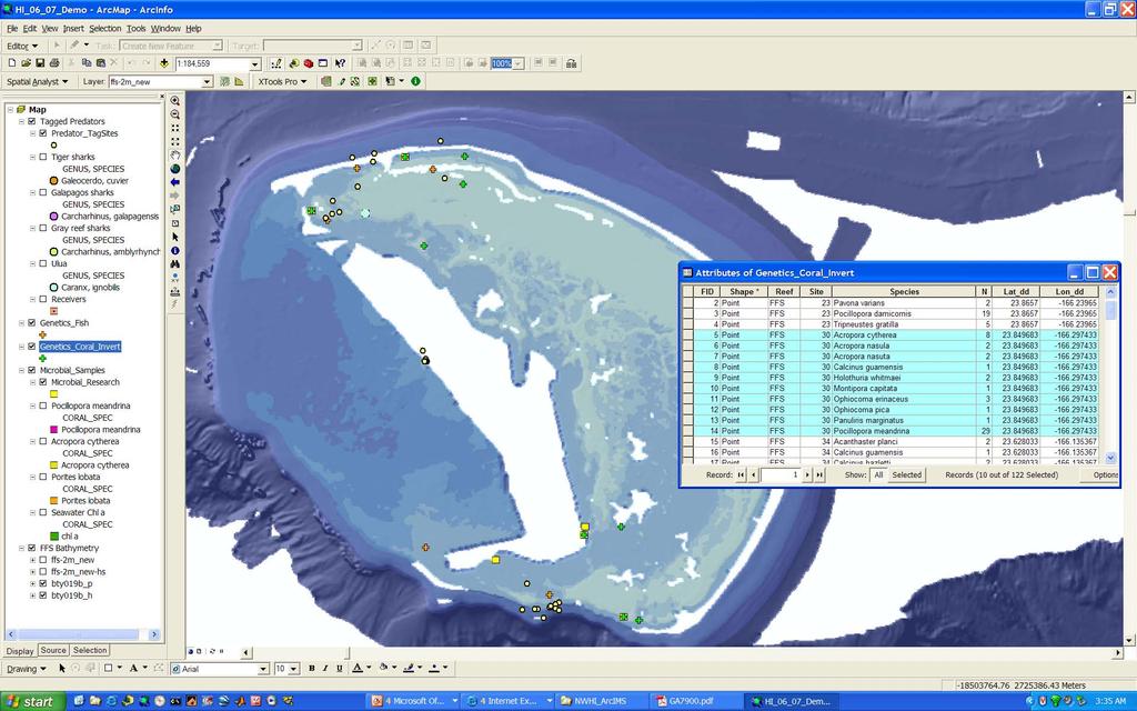
9 Visualizing Data

 Vulnerability")
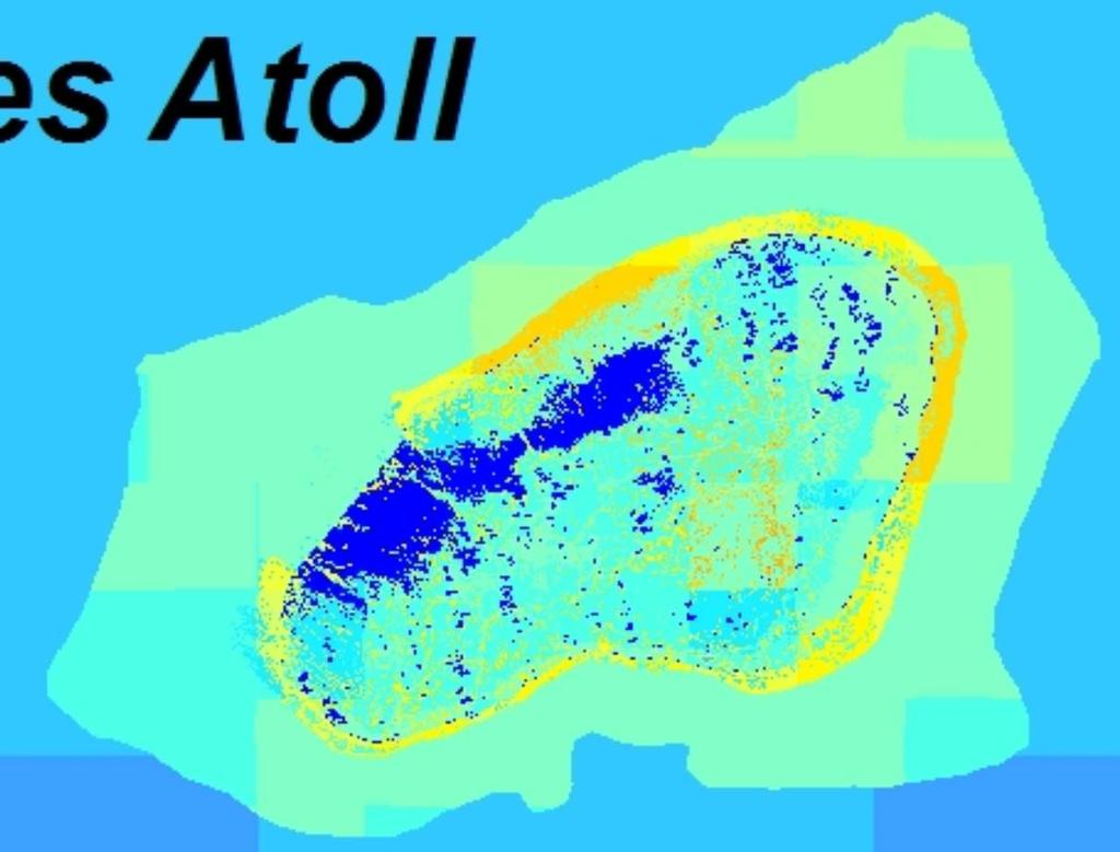
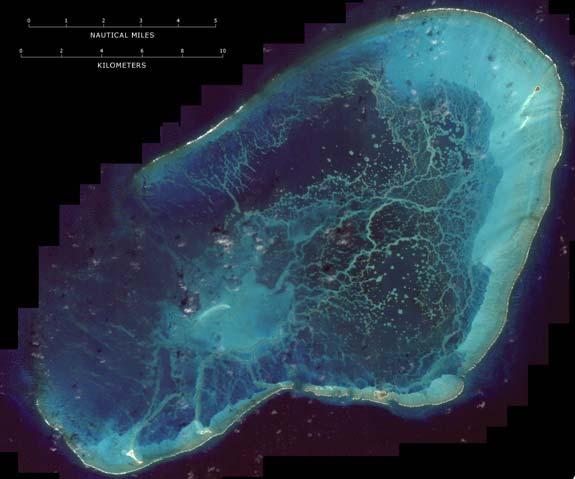
10 Northwestern Hawaiian Islands Threat Assessment Objective: Create habitat-based threat maps for the Northwestern Hawaiian Islands with the expert survey data. Habitat Data for Midway Atoll (Interpreted IKONOS NOS) Vulnerability scores mapped by habitat Spatial Vulnerability Scores

11 Northwestern Hawaiian Islands Vessel Traffic Objective: Identify spatial data sets to use for habitat-based threat assessment. Example using patterns of vessel traffic in the Northwestern Hawaiian Islands. (Franklin, in press)
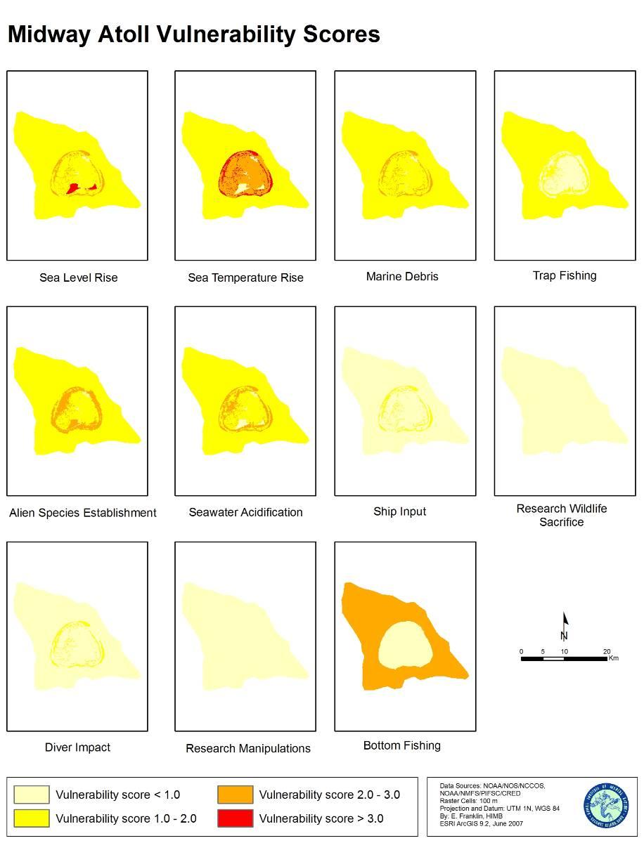
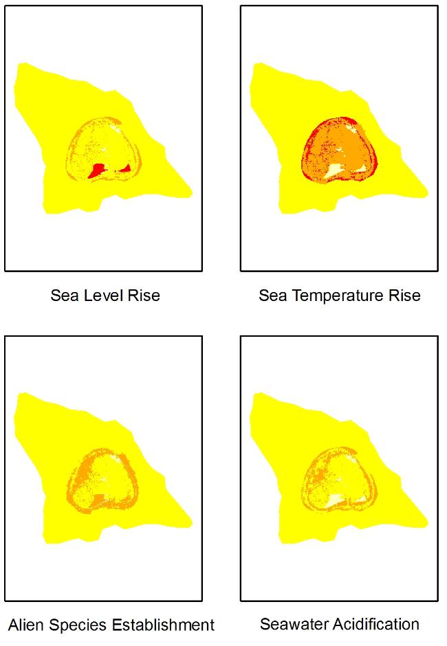
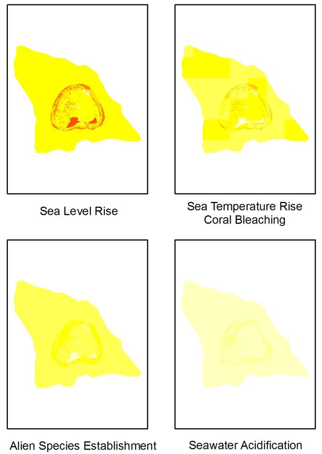
12 Northwestern Hawaiian Islands Threat Assessment
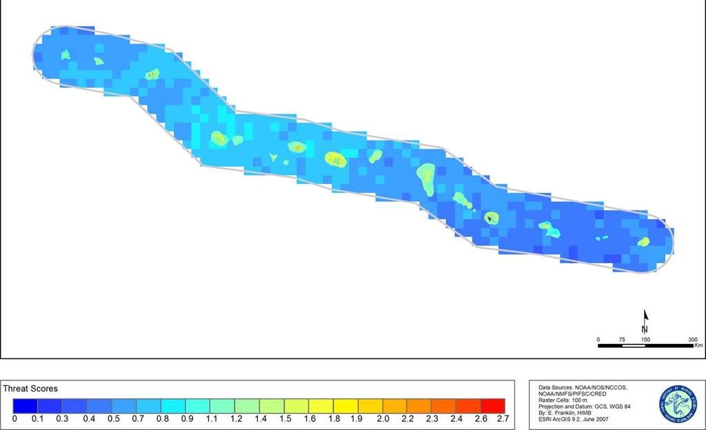
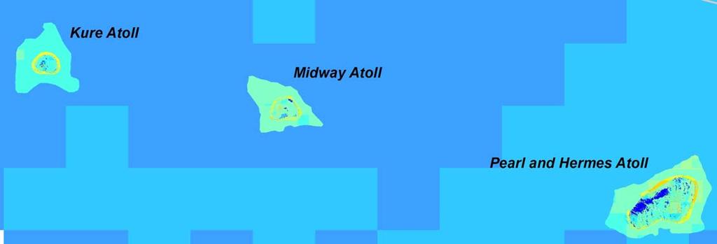
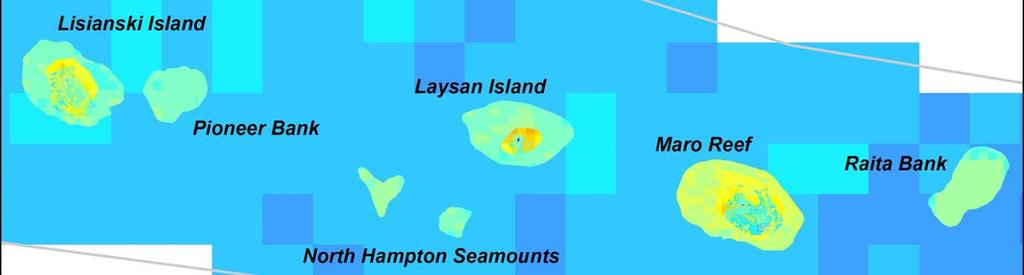
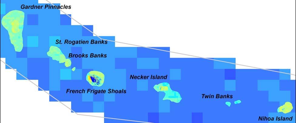
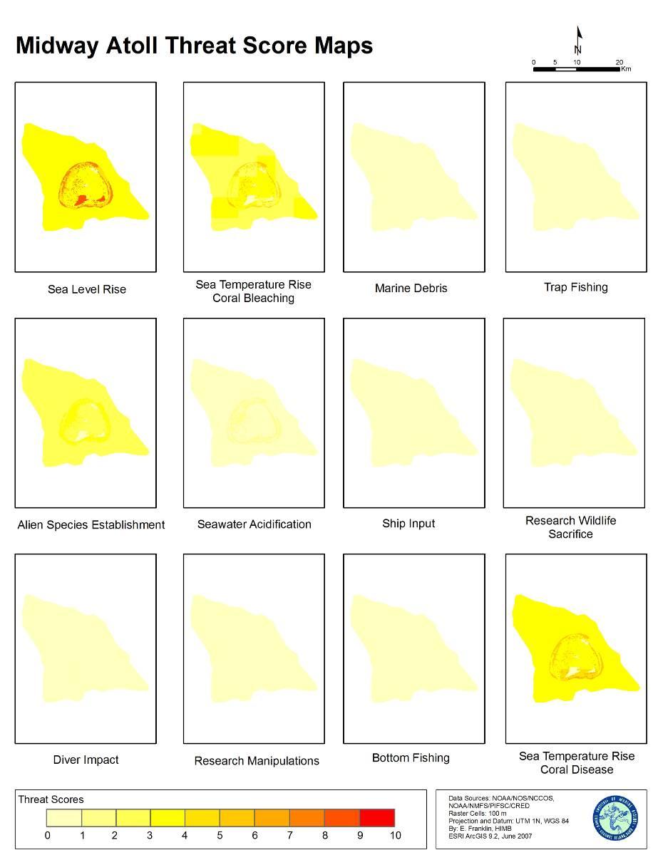
13 Northwestern Hawaiian Islands Threat Scores


14 Northwestern Hawaiian Islands Thermal Anomalies Gradient of thermal anomalies along NWHI facilitates research on effects of sea temperature on resilience of reef communities. Pearl and Hermes Atoll Data: NOAA/NESDIS; University of North Carolina


.")

15 Global Symbiodinium Database and Map Site Objective: A web-enabled database and mapping website for coral symbiont (Symbiodinium) sequence data and attribute information (host, locale, investigator, year). photo credits: bleached corals by James Watt, symbiodinium cells by Scott Santos
16 Summary Information management to ensure long-term data integrity HIMB-NWHI data to integrate with Monument Information Management System and Pacific regional IOOS efforts and contribute biological data Threat assessment provides cumulative impact framework for management of the NWHI Marine National Monument Coral symbiont research in NWHI can be catalyst for global data portal that facilitates coral reef resilience studies
17 Thank You! Questions? MC: (808) ECF: (808) erik.franklin
Coral Disease and Community Structure throughout the Northwestern Hawaiian Islands. Kailey Pascoe
 Coral Disease and Community Structure throughout the Northwestern Hawaiian Islands Kailey Pascoe Marine Science Department University of Hawai i at Hilo Advisors Dr. Steven Colbert Marine Science Department
NOAA Seafloor Mapping in the Pacific Islands Region
 NOAA Seafloor Mapping in the Pacific Islands Region NOAA Coral Reef Ecosystem Division Pacific Island Fisheries Science Center Mission Statement Conduct research that provides scientific information and
National Marine Sanctuary Program
 National Marine Sanctuary Program NMSP/USGS Joint Seabed Mapping Initiative: September 2004 AA National Ocean Service National Marine Sanctuaries Interim Report September 2004 Background: Since 2002,
Marine Spatial Planning: A Tool for Implementing Ecosystem-Based Management
 Marine Spatial Planning: A Tool for Implementing Ecosystem-Based Management Steven Murawski, Ph.D., Ecosystem Goal Team Lead National Oceanic and Atmospheric Administration NOAA November 16, 2009 1 To
SAFMC Habitat and Ecosystem IMS. Habitat and Environmental Protection Advisory Panel Meeting
 SAFMC Habitat and Ecosystem IMS Habitat and Environmental Protection Advisory Panel Meeting Charleston, SC November 18, 2008 Project Overview Phase 1 develop and host an Internet Map Server (IMS) application
Introducing the. a partnership of
 Introducing the a partnership of Background Need for online atlas identified by managers and researchers to make coastal data available Shoreline data Ocean and coastal resources Sea-level rise potential
GERSVIEW: A New Database for Web Mapping
 GERSVIEW: A New Database for Web Mapping William J. Hernández, M.S. Graduate Student Department of Marine Sciences-UPRM Fernando Gilbes, Ph.D. Associate Professor Department of Geology-UPRM Overview Introduction
Introduction: The Gulf of Mexico Alliance. The Gulf GAME project MERMAid and PHINS Results & Conclusions What s next? Examples
 AAG Las Vegas March 25, 2009 Introduction: Ocean governance and Ecosystem-Based Management The Gulf of Mexico Alliance Habitat Identification and Characterization The Gulf GAME project MERMAid and PHINS
an accessible interface to marine environmental data Russell Moffitt
 an accessible interface to marine environmental data Russell Moffitt The Atlas Project GOAL: To provide a single point of access to oceanographic and environmental data for use by marine resource researchers,
Sister Sanctuaries: Linking the Science and Management of Coral Reefs in Cuba and the U.S.
 Sister Sanctuaries: Linking the Science and Management of Coral Reefs in Cuba and the U.S. Memorandum of Understanding on Cooperation in the Conservation and Management of Marine Protected Areas Seventh
Papahanaumokuakea 11 th Pacific Science Inter-congress Papeete, Tahiti. March 2009
 Papahanaumokuakea 11 th Pacific Science Inter-congress Papeete, Tahiti March 2009 Biological and Biogeographic Significance A few Monumental facts Largest fully protected marine protected area on Earth
Your web browser (Safari 7) is out of date. For more security, comfort and the best experience on this site: Update your browser Ignore
 is out of date. For more security, comfort and the best experience on this site: Update your browser Ignore") Your web browser (Safari 7) is out of date. For more security, comfort and the best experience on this site: Update your browser Ignore Activitydevelop PRO TECTING THE MARIANA TRENCH Why is it important
Your web browser (Safari 7) is out of date. For more security, comfort and the best experience on this site: Update your browser Ignore Activitydevelop PRO TECTING THE MARIANA TRENCH Why is it important
Access to IOOS Data Relevant to OOI. Kathleen Bailey NOAA/NOS/IOOS January 6, 2016
 Access to IOOS Data Relevant to OOI Kathleen Bailey NOAA/NOS/IOOS January 6, 2016 The U.S. Integrated Ocean Observing System (IOOS) Federal Regional Satellites 600+: Buoys, Water Level stations, Coastal
Geospatial Decision Support Tools for Planning of Marine Protected Areas in California
 Geospatial Decision Support Tools for Planning of Marine Protected Areas in California WILL MCCLINTOCK (UNIVERSITY OF CALIFORNIA SANTA BARBARA), MATT MERRIFIELD (THE NATURE CONSERVANCY), SOPHIE DE BEUKELAER
Empowered lives. Resilient nations. Data for People and Planet. powered by
 Empowered lives. Resilient nations. Data for People and Planet powered by Overview As we enter the fourth industrial revolution, technology is revolutionizing our ability to map nature. Satellite data
Ellen L. Mecray NOAA Regional Climate Services Director, Eastern Region Taunton, MA
 Ellen L. Mecray NOAA Regional Climate Services Director, Eastern Region Taunton, MA Regions of the US National Climate Assessment What we Observe: Climate changes and impacts Extreme precipitation and
SST (NRL/NLOM, 28 Sept. 2004) (A global, surface layer product)
 (A global, surface layer product)") SST (NRL/NLOM, 28 Sept. 2004) (A global, surface layer product) SST (NRL/NLOM, 28 Sept. 2004) SST Forecast (NRL/NLOM, 20 Oct. 2004) UH/IPRC Asia-Pacific Data-Research Center (APDRC) Jay McCreary, Peter
SST (NRL/NLOM, 28 Sept. 2004) (A global, surface layer product) SST (NRL/NLOM, 28 Sept. 2004) SST Forecast (NRL/NLOM, 20 Oct. 2004) UH/IPRC Asia-Pacific Data-Research Center (APDRC) Jay McCreary, Peter
MARCO s Mapping and Planning Portal. Coastal Geotools 2011 Special Interest Meeting-CMSP Portals & Atlases March 21, 2011 Jay Odell
 MARCO s Mapping and Planning Portal Coastal Geotools 2011 Special Interest Meeting-CMSP Portals & Atlases March 21, 2011 Jay Odell Overview What is a Portal? Description and demo of Mapping and Planning
U.S. Marine Protected Areas Boundaries: MPA Inventory
 Page 1 of 20 U.S. Marine Protected Areas Boundaries: MPA Inventory File Geodatabase Feature Class Thumbnail Not Available Tags Marine Conservation Areas, ngda, oceans, Ocean Conservation, United States,
African Coastal Atlas developments. 10 July 2008 EEA Copenhagen, Denmark
 African Coastal Atlas developments 10 July 2008 EEA Copenhagen, Denmark Africa Overview Africa has approximately 40 000 km of coast across 32 mainland countries and four island states. Africa's coastal
Biogeographic Approach to Coastal Assessments & Spatial Planning
 NOAA s Biogeographic Approach to Coastal Assessments & Spatial Planning Mark E. Monaco Mark.Monaco@noaa.gov Center for Coastal Monitoring and Assessment http://ccma.nos.noaa.gov/about/biogeography Biogeography
The Index to Marine and Lacustrine Geological Samples
 The Index to Marine and Lacustrine Geological Samples Community access to common information on sample collections Kelly J. Stroker 1, Jennifer Jencks 2 1 Cooperative Institute for Research in Environmental
Overview. Project Background Project Approach: Content and Application Development Application Demonstration Future Developments
 Overview Project Background Project Approach: Content and Application Development Application Demonstration Future Developments Southeast Pressures: Continued Population Growth Transportation Corridors
PRIORITY TWO-YEAR ACTIVITIES ( ) PRIORITY ONE: INTERNATIONAL RECOGNITION OF ECOLOGICAL IMPORTANCE
 PRIORITY ONE: INTERNATIONAL RECOGNITION OF ECOLOGICAL IMPORTANCE") PREFACE: The Work Programme goals and priority activities were developed at the Second Joint Meeting of the Signatories to the Hamilton Declaration and the Sargasso Sea Commission, held in Key West Florida,
PREFACE: The Work Programme goals and priority activities were developed at the Second Joint Meeting of the Signatories to the Hamilton Declaration and the Sargasso Sea Commission, held in Key West Florida,
Building capacity to support decisionmaking for protection and management of marine areas
 Credit_Deep Atlantic Stepping Stones Science Team_IFE_URI_NOAA_no3 Credit: John Weller, john@lastocean.com Credit: John Weller, john@lastocean.com Credit: John Weller, john@lastocean.com Credit: Sarah
THE WASHINGTON COASTAL ATLAS
 THE ICAN COASTAL ATLAS MEDIATOR PROTOTYPE AND CONNECTING THE WASHINGTON COASTAL ATLAS Liz O Dea 1, Yassine Lassoued 2, Tanya Haddad 3, Declan Dunne 2 1 GIS Services Unit, WA State Dept. of Ecology 2 Coastal
WELCOME & INTRODUCTION
 MPA Management Capacity Building Training Module 1: WELCOME & INTRODUCTION Participants Distinguished Guests Welcome Site Overviews of MPAs represented Overview of Training Program What are Today s Objectives?
The Science of Coastal and Marine Spatial Planning A Workshop for Oregon Academic Faculty
 The Science of Coastal and Marine Spatial Planning A Workshop for Oregon Academic Faculty November 29 30, 2011 Oregon State University Lisa DeBruyckere, Coordinator West Coast Governors Agreement on Ocean
GEOGRAPHIC INFORMATION SYSTEMS AND IT SOLUTIONS FOR THE ENVIRONMENT
 GEOGRAPHIC INFORMATION SYSTEMS AND IT SOLUTIONS FOR THE ENVIRONMENT Mission We focus on Solutions is a worldwide operating business offering Geographic Information Systems and IT solutions to assist environmental
Appendix I: Geographic Information System Data Sources
 Appendix I: Geographic Information System Data Sources Draft Environmental Impact Statement/Overseas Environmental Impact Statement Hawaii-Southern California Training and Testing TABLE OF CONTENTS...
Underwater Parks: Three Case Studies, and a Primer on Marine Boundary Issues. Robert E. Johnson Leland F. Thormahlen
 Robert E. Johnson Leland F. Thormahlen Underwater Parks: Three Case Studies, and a Primer on Marine Boundary Issues Unlike boundaries on land, most marine boundaries are not marked with monuments or fences.
Environmental Response Management Application
 Environmental Response Management Application Coastal Response Research Center Nancy Kinner, Michele Jacobi, Rob Braswell, Kurt Schwehr & Amy Merten RRT III May 14, 2008 1 Talk Outline Overview of Center
Proper Data Management Responsibilities to Meet the Global Ocean Observing System (GOOS) Requirements
 Requirements") Data Buoy Cooperation Panel XXVI Oban, Scotland, UK 27 September 2010 Proper Data Management Responsibilities to Meet the Global Ocean Observing System (GOOS) Requirements William Burnett Data Management
Data Buoy Cooperation Panel XXVI Oban, Scotland, UK 27 September 2010 Proper Data Management Responsibilities to Meet the Global Ocean Observing System (GOOS) Requirements William Burnett Data Management
Geospatial Information for Disease Prevention and Control. INSPIRE Conference 2013
 Geospatial Information for Disease Prevention and Control Dr. Virginia Estevez, Senior Expert GIS Florence, 25 th June 2013 ECDC overview ECDC The European Centre for Disease Prevention and Control (ECDC),
A map of human impacts to a pristine coral reef ecosystem,
 Coral Reefs (2009) 28:635 650 DOI 10.1007/s00338-009-0490-z REPORT A map of human impacts to a pristine coral reef ecosystem, the Papahānaumokuākea Marine National Monument K. A. Selkoe Æ B. S. Halpern
Marine Spatial Planning, a Norwegian user case NSHC33
 Marine Spatial Planning, a Norwegian user case NSHC33 Marine Spatial Management Tool Support the marine spatial planning process with updated and reliable geospatial information Marine management is important
Data Management for Algal Monitoring in the Gulf of Mexico
 Data Management for Algal Monitoring in the Gulf of Mexico Scott Cross NOAA National Oceanographic Data Center/ Coastal Data Development Center (NCDDC) Outline History Current & Future Directions Needs
CHAPTER 22 GEOGRAPHIC INFORMATION SYSTEMS
 CHAPTER 22 GEOGRAPHIC INFORMATION SYSTEMS PURPOSE: This chapter establishes the administration and use of to improve the quality and accessibility of Department s spatial information and support graphical
DFO Maritimes Region Update. Gulf of Maine Council - Coastal and Marine Spatial Planning (CMSP) Committee Web-Ex May 16, 2017
 Committee Web-Ex May 16, 2017") DFO Maritimes Region Update Gulf of Maine Council - Coastal and Marine Spatial Planning (CMSP) Committee Web-Ex May 16, 2017 1 National Oceans Priorities Marine Conservation Targets Oceans Protection Plan
DFO Maritimes Region Update Gulf of Maine Council - Coastal and Marine Spatial Planning (CMSP) Committee Web-Ex May 16, 2017 1 National Oceans Priorities Marine Conservation Targets Oceans Protection Plan
A TOOLKIT FOR MARINE SPATIAL PLANNING Version: 17 July, 2009
 A TOOLKIT FOR MARINE SPATIAL PLANNING Version: 17 July, 2009 NEED FOR MARINE SPATIAL PLANNING The health of marine ecosystems is declining, and use conflicts in the marine environment are increasing, in
SOUTHEAST OCEAN AND COASTAL ACIDIFICATION NETWORK. Scott Noakes, University of Georgia 2:00pm 2:30pm
 SOUTHEAST OCEAN AND COASTAL ACIDIFICATION NETWORK Scott Noakes, University of Georgia 2:00pm 2:30pm Agenda Overview of SOCAN SOCAN Mission Statement SOCAN Steering Committee SOCAN Executive Committee State
INSPIRE as a Powerful Tool for Managing and Opening Environmental Data
 INSPIRE as a Powerful Tool for Managing and Opening Environmental Data Leszek Litwin Maria Lenartowicz 1, Alina Litwiak 2, Elżbieta Duraj 2, Łukasz Łukasiewicz 2, Leszek Litwin 2 1 Chief Inspectorate of
Coast Survey Providing Improved Access to Maritime Navigation Products and Services
 Coast Survey Providing Improved Access to Maritime Navigation Products and Services Kurt A. Nelson, Branch Chief CGTP Leland Snyder, Branch Chief FADS Office of Coast Survey Agenda Current Coast Survey
Climate Change in Newfoundland & Labrador
 Climate Change in Newfoundland & Labrador Impacts and Adaptation Newleef Conference 08 October 2015 Met-Ocean Services The Team 55 personnel; 24/7 operational weather forecast desk; Equipment technician
Marine Spatial Planning (MSP): A practical approach to ecosystembased
: A practical approach to ecosystembased") Marine Spatial Planning (MSP): A practical approach to ecosystembased management Erik Olsen, Institute of Marine Research, Norway Fanny Douvere, International Oceanographic Commission Overview Why we need
Marine Spatial Planning (MSP): A practical approach to ecosystembased management Erik Olsen, Institute of Marine Research, Norway Fanny Douvere, International Oceanographic Commission Overview Why we need
Image Services Providing Access to Scientific Data at NOAA/NCEI
 Image Services Providing Access to Scientific Data at NOAA/NCEI Jesse Varner Cooperative Institute for Research in Environmental Sciences (CIRES), University of Colorado John Cartwright NOAA National Centers
University of New Hampshire Scholars' Repository
 University of New Hampshire University of New Hampshire Scholars' Repository Center for Coastal and Ocean Mapping Center for Coastal and Ocean Mapping 3-2009 Environmental Response Management Application
Economic Valuation of the Montego Bay Marine Park
 Economic Valuation of the Montego Bay Marine Park Methodology Test Cases Presenter: Brian L. Zane What? A means to estimate the value of environmental resources How? Different methodologies exist Total
NOAA s OCM: Services, tools and collaboration opportunities & Puerto Rico s NE Marine Corridor as a case study
 NOAA s OCM: Services, tools and collaboration opportunities & Puerto Rico s NE Marine Corridor as a case study Dr. Antares Ramos Álvarez NOAA s Office of Coastal Management September 15 th, 2016 Conservation
1) make sure folks know what s available in terms of geospatial data and resources that could contribute to their decision support toolkits;
 make sure folks know what s available in terms of geospatial data and resources that could contribute to their decision support toolkits;") Introduction 1 2001 It was born out of the recognition that several of the regions prominent resource management agencies have similar, if not shared, requirements for GIS data. Some of the underlying
Introduction 1 2001 It was born out of the recognition that several of the regions prominent resource management agencies have similar, if not shared, requirements for GIS data. Some of the underlying
NOAA s Big Data Project: Vision and Approach
 NOAA s Big Data Project: Vision and Approach Andy Bailey, BDP Technical Lead NOAA Office of the Chief Information Officer What is NOAA? United States Government Agency NOAA ~ National Oceanic and Atmospheric
Capturing a Holistic Understanding of a Large Marine Ecosystem The NOAA Gulf of Mexico Data Atlas
 Capturing a Holistic Understanding of a Large Marine Ecosystem The NOAA Gulf of Mexico Data Atlas NODC / National Coastal Data Development Center gulfalas.noaa.gov Need: data that contribute to long-term
CLIMAR-III Third JCOMM Workshop on Advances in Marine Climatology 6-9 May Gdynia, Poland
 CLIMAR-III Third JCOMM Workshop on Advances in Marine Climatology 6-9 May 2008. Gdynia, Poland Catherine Marzin Historical Ecology Program Manager National Marine Sanctuary Program Stefan Claesson Research
Ecological Vulnerability Modeling Delineating Areas of Vulnerability to Algal Invasion in Hawaii using a Niche Model
 Ecological Vulnerability Modeling Delineating Areas of Vulnerability to Algal Invasion in Hawaii using a Niche Model Investigators: John J. Kineman (Senior Research Scientist, University of Colorado and
Preliminary Vulnerability Assessment of Coastal Flooding Threats - Taylor County, Florida
 Preliminary Vulnerability Assessment of Coastal Flooding Threats - Taylor County, Florida North Central Florida Regional Planning Council Northeast Florida Regional Council April 28, 2016 BACKGROUND This
NOAA Surface Weather Program
 NOAA Surface Weather Program Maintenance Decision Support System Stakeholder Meeting #9 Jim O Sullivan NOAA Surface Weather Program Manager NWS Office of Climate, Water, and Weather Services September
Presentation for the Institute of International & European Affairs
 Presentation for the Institute of International & European Affairs Kathryn D. Sullivan, Ph.D. Under Secretary of Commerce for Oceans and Atmosphere & NOAA Administrator June 3, 2016 Overview NOAA 101 Closing
Designing Networks of Marine Protected Areas in DFO s Three Atlantic Bioregions
 Designing Networks of Marine Protected Areas in DFO s Three Atlantic Bioregions Presentation for Indigenous Protected Areas Workshop Max Westhead, DFO and Adrian Gerhartz-Abraham, Dalhousie March 29, 2017
Marine debris movement and concentration within the North Pacific Ocean
 Marine debris movement and concentration within the North Pacific Ocean PICES 2012 Annual Meeting, S12 Hiroshima, Japan Carey Morishige NOAA Marine Debris Program / IMSG NOAA PIFSC CRED Evan Howell NOAA
Spatial Data Availability Energizes Florida s Citizens
 NASCIO 2016 Recognition Awards Nomination Spatial Data Availability Energizes Florida s Citizens State of Florida Agency for State Technology & Department of Environmental Protection Category: ICT Innovations
OCEANS, CORAL REEFS NOAA
 1 of 5 From the HORIZON Solutions Site, www.solutions-site.org OCEANS, CORAL REEFS NOAA Helps National Coral Reef Institute Grow Coral in Laboratory for Transplantation to Damaged Reefs By Mar 2, 2008,
CHAPTER 12: TERRESTRIAL LAYERS
 CHAPTER 12: TERRESTRIAL LAYERS Coordinator: Shannon McElvaney Hawai`i Natural Heritage Program mcelvane@hawaii.edu Theme Description: Land use corresponds to the socio-economic description (or functional
GEOGRAPHIC INFORMATION SYSTEMS (GIS) AT GERS LAB
 AT GERS LAB") GEOGRAPHIC INFORMATION SYSTEMS (GIS) AT GERS LAB Fernando Gilbes Santaella GERS Lab-Department of Geology University of Puerto Rico at Mayaguez fernando.gilbes@upr.edu Geological and Environmental Remote
GEOGRAPHIC INFORMATION SYSTEMS (GIS) AT GERS LAB Fernando Gilbes Santaella GERS Lab-Department of Geology University of Puerto Rico at Mayaguez fernando.gilbes@upr.edu Geological and Environmental Remote
STATEMENT OF CAPABILITY
 BELIZE MARINE CONSERVATION AND CLIMATE ADAPTATION PROJECT (MCCAP) Ministry of Forestry, Fisheries and Sustainable Development STATEMENT OF CAPABILITY Consultant for the Realignment of Boundaries and the
Spatially Enabled Society
 International Seminar on Land Administration Trends and Issues in Asia and the Pacific Region Spatially Enabled Society Abbas Rajabifard Vice Chair PCGIAP-WG3 Vice-President (President Elect), GSDI Association
Coastal Erosion & Climate Change: PRIDE 2005 Towards an Alaska Wind/Wave Climatology
 Coastal Erosion & Climate Change: PRIDE 2005 Towards an Alaska Wind/Wave Climatology 2 nd PRIDE Workshop August 9-10, 2005 David Atkinson, Int l Arctic Research Center, Univ. Of Alaska-Fairbanks James
E.W. Johnson 1 and M. Plivelich 2
 E.W. Johnson 1 and M. Plivelich 2 Summary A regionalized approach is being established for the collaborative stewardship of the National Hydrography Dataset (NHD) by state, federal, and university partners
Seabed knowledge In support of UN SDGs
 Seabed knowledge In support of UN SDGs Evert Flier Fiskerifaglig forum 2. november 2017 Hydrography & small scale fishing Hydrography in Transition Serving the Maritime Community Hydrography in Transition
ESBN. Working Group on INSPIRE
 ESBN Working Group on INSPIRE by Marc Van Liedekerke, Endre Dobos and Paul Smits behalf of the WG members WG participants Marc Van Liedekerke Panos Panagos Borut Vrščaj Ivana Kovacikova Erik Obersteiner
THE USE OF GEOSPATIAL DATA TO SUPPORT VULNERABILITY MAPPING OF THE OREGON COAST. Kelvin Raiford MS Candidate Geography Department of Geosciences
 THE USE OF GEOSPATIAL DATA TO SUPPORT VULNERABILITY MAPPING OF THE OREGON COAST Kelvin Raiford MS Candidate Geography Department of Geosciences INTRODUCTION This study is an outcome of the project Geospatial
Launch of Data Collection or Production Centre for World Weather Information Service
 Launch of Data Collection or Production Centre for World Weather Information Service The Hong Kong Observatory (HKO) announces that the Data Collection or Production Centre (DCPC) for the World Weather
Overview. Gulf of Mexico Alliance Ocean and Coastal Mapping Regional Ecosystem Data Management (REDM) Q2O (QARTOD to OGC) Things to Consider
 Q2O (QARTOD to OGC) Things to Consider") 1 Overview Gulf of Mexico Alliance Ocean and Coastal Mapping Regional Ecosystem Data Management (REDM) Q2O (QARTOD to OGC) Things to Consider 2 Gulf Of Mexico Alliance Partnership of the states of Alabama,
1 Overview Gulf of Mexico Alliance Ocean and Coastal Mapping Regional Ecosystem Data Management (REDM) Q2O (QARTOD to OGC) Things to Consider 2 Gulf Of Mexico Alliance Partnership of the states of Alabama,
INSPIRE implementation in the Turkish Ministry of Environment and Urbanization Producing and Publishing Environmental Data
 INSPIRE implementation in the Turkish Ministry of Environment and Urbanization Producing and Publishing Environmental Data Ezgi Sarmusak Urban Planner, MoEU Sibel Süer Toybıyık - Assistant Expert, MoEU
JIMAR ANNUAL REPORT FOR FY NOAA OFFICE: NOAA Fisheries Pacific Islands Fisheries Science Center (PIFSC)
") JIMAR ANNUAL REPORT FOR FY 2010 P.I./SPONSOR NAME: Kevin Weng, Bert Kikkawa NOAA OFFICE: NOAA Fisheries Pacific Islands Fisheries Science Center (PIFSC) PROJECT PROPOSAL TITLE: Rescue, Compilation, and
JIMAR ANNUAL REPORT FOR FY 2010 P.I./SPONSOR NAME: Kevin Weng, Bert Kikkawa NOAA OFFICE: NOAA Fisheries Pacific Islands Fisheries Science Center (PIFSC) PROJECT PROPOSAL TITLE: Rescue, Compilation, and
Coastal Response Research Center. Nancy Kinner University of New Hampshire (UNH) Michele Jacobi NOAA ORR. September 27, 2007
 Michele Jacobi NOAA ORR. September 27, 2007") Coastal Response Research Center Nancy Kinner University of New Hampshire (UNH) Michele Jacobi NOAA ORR September 27, 2007 1 Coastal Response Research Center (CRRC) CRRC is partnership between NOAA s Office
Coastal Response Research Center Nancy Kinner University of New Hampshire (UNH) Michele Jacobi NOAA ORR September 27, 2007 1 Coastal Response Research Center (CRRC) CRRC is partnership between NOAA s Office
Brazil Paper for the. Second Preparatory Meeting of the Proposed United Nations Committee of Experts on Global Geographic Information Management
 Brazil Paper for the Second Preparatory Meeting of the Proposed United Nations Committee of Experts on Global Geographic Information Management on Data Integration Introduction The quick development of
COVERAGE-Sargasso Sea
 COVERAGE-Sargasso Sea A Collaborative Project between NASA and the Sargasso Sea Commission Dr. Vardis Tsontos Dr. Jorge Vazquez NASA Jet Propulsion Laboratory, California Institute of Technology UN-HQ
Hawaii s Coral Reefs. Developed by: Bobby Hsu, Jackie Gaudioso, and Diane Duke
 Grade Level: Kindergarten Hawaii s Coral Reefs Developed by: Bobby Hsu, Jackie Gaudioso, and Diane Duke Purpose: This curriculum is designed to communicate: I. What is coral: overview coral anatomy, distribution,
NOAA/NSTA Symposium: The Heat is On! Climate Change and Coral Reef Ecosystems Saturday, March 21, 2009
 NOAA/NSTA Symposium: The Heat is On! Climate Change and Coral Reef Ecosystems Saturday, 8:00 AM 8:25 AM Welcome, Introductions, Goals for the Symposium Flavio Mendez, Senior Director, NSTA Learning Center
TOWARDS CLIMATE-RESILIENT COASTAL MANAGEMENT: OPPORTUNITIES FOR IMPROVED ICZM IN BELIZE
 TOWARDS CLIMATE-RESILIENT COASTAL MANAGEMENT: OPPORTUNITIES FOR IMPROVED ICZM IN BELIZE CHANTALLE SAMUELS Coastal Zone Management Authority and Institute The Caribbean Community Climate Change Centre VULNERABILITY
Regione Umbria. ESRI EMEA User Conference 2010 Rome, October 27th 2010
 Direzione Ambiente, Territorio e Infrastrutture Servizio Informatico/Informativo: geografico, ambientale e territoriale ESRI EMEA User Conference 2010 Rome, October 27th 2010 Arch. Ambra Ciarapica, Dott.
Multibeam Mapping of Feature Rich Seafloor in the U.S. Pacific Remote Islands Marine National Monument and on Mendocino Ridge off the California Coast
 University of New Hampshire University of New Hampshire Scholars' Repository Center for Coastal and Ocean Mapping Center for Coastal and Ocean Mapping 3-2015 Multibeam Mapping of Feature Rich Seafloor
Population Trends Along the Coastal United States:
 Coastal Trends Report Series Population Trends Along the Coastal United States: 1980-2008 U.S. Department of Commerce National Oceanic and Atmospheric Administration National Ocean Service Assessing the
An international research expedition assess the biodiversity and health of New Caledonia coral reefs
 Nouméa, 28.11.2013. An international research expedition assess the biodiversity and health of New Caledonia coral reefs A research mission on coral reefs in New Caledonia conducted in association with
ArcGIS for INSPIRE. Marten Hogeweg Satish Sankaran
 ArcGIS for INSPIRE Marten Hogeweg Satish Sankaran Outline What is ArcGIS ArcGIS for INSPIRE Web GIS Case Studies Roadmap Q&A What is INSPIRE? INSPIRE is the legal framework for a European Spatial Data
Annex I. Common criteria for the choice of Protected Marine and Coastal Areas that could be included in SPAMI list
 Annex I Common criteria for the choice of Protected Marine and Coastal Areas that could be included in SPAMI list PROTOCOL CONCERNING SPECIALLY PROTECTED AREAS AND BIOLOGICAL DIVERSITY IN THE MEDITERRANEAN
Treasure Coast Science Scope and Sequence
 Course: Marine Science I Honors Course Code: 2002510 Quarter: 3 Topic(s) of Study: Marine Organisms and Ecosystems Bodies of Knowledge: Nature of Science and Life Science Standard(s): 1: The Practice of
PARC NATUREL DE LA MER DE CORAIL. The planned management project. with 15 objectives. Jean-Michel Boré - IRD
 Jean-Michel Boré - IRD PARC NATUREL DE LA MER DE CORAIL The planned management project with 15 objectives 1 CHAPTER 1 Protected natural and cultural heritage OBJECTIVE 1 Carefully protect the ecosystems
Marine Spatial Management Tool
 Marine Spatial Management Tool Marine Spatial Management Tool Support the marine spatial planning process with updated and reliable geospatial information Marine management is important to Norway with
What Are Coral Reefs?
 ELA.08.CR.1.9.132 C1 T9 Sample Item Id: ELA.08.CR.1.9.132 Grade/Model: 08 / 1b Claim: 1: Students can read closely and analytically to comprehend a range of increasingly complex literary and informational
New EU efforts to assess the state of the marine environment: the EMODnet Chemistry pilot project
 New EU efforts to assess the state of the marine environment: the EMODnet Chemistry pilot project Matteo Vinci and Alessandra Giorgetti, OGS NODC group, OCE September 2013 - IMDIS 2013, Lucca Overview
Rainfall-River Forecasting: Overview of NOAA s Role, Responsibilities, and Services
 Dr. Thomas Graziano Chief Hydrologic Services Division NWS Headquarters Steve Buan Service Coordination Hydrologist NWS North Central River Forecast Center Rainfall-River Forecasting: Overview of NOAA
Manipulating the coral-algal holobiont
 Manipulating the coral-algal holobiont Todd C. LaJeunesse Interventions to Increase the Resilience of Coral Reefs (May 31, 2018) Preface Skipping over most of the details to get the punch lines. My perspectives
Relationships between the length of select head bones and body size for some Hawaiian parrotfishes (subfamily Scarinae)
") 13 Relationships between the length of select head bones and body size for some Hawaiian parrotfishes (subfamily Scarinae) KeN LoNgeNeCKer (Hawaii Biological Survey, Bishop Museum, 1525 Bernice Street,
13 Relationships between the length of select head bones and body size for some Hawaiian parrotfishes (subfamily Scarinae) KeN LoNgeNeCKer (Hawaii Biological Survey, Bishop Museum, 1525 Bernice Street,
SEMESTER AT SEA COURSE SYLLABUS. Introduction to Oceanography
 COURSE DESCRIPTION SEMESTER AT SEA COURSE SYLLABUS Introduction to Oceanography More of an exploration of the seas than a class, this course engages students in direct observation, reflection, and analysis.
CSO Climate Data Rescue Project Formal Statistics Liaison Group June 12th, 2018
 CSO Climate Data Rescue Project Formal Statistics Liaison Group June 12th, 2018 Dimitri Cernize and Paul McElvaney Environment Statistics and Accounts Presentation Structure Background to Data Rescue Project
The story of sharing environmental data
 The story of sharing environmental data Kallio, Pyhälahti, Harju, Teiniranta, Lahtinen, Finnish Environment Institute SYKE OKFestival, Finnish Open Data, 18. Sep 2012 Contents Call for environmental knowledge
Ministry of ICT of I.R.IRAN
 The ECO 8/6 mill km 2 10 Slamic countries ~330 mill people Oil, Gas, Industries,Tourism 2 Issue transformation in last decade Problem solving needs more integrated approach More interaction &complexity
Lesson 3: Protecting Ocean Hotspots
 Lesson 3: Protecting Ocean Hotspots Name: Date: Engage Think about the ocean and the seafloor. 1. Draw a sketch of what you picture when you think about the seafloor. Explore 2. When your teacher projects
NOAA Arctic Priorities and Potential Contributions to PPP/YOPP. Randall Dole NOAA Earth System Research Laboratory Physical Sciences Division
 NOAA Arctic Priorities and Potential Contributions to PPP/YOPP Randall Dole NOAA Earth System Research Laboratory Physical Sciences Division 1 NOAA s Arctic Goals Forecast Sea Ice Strengthen Foundational