PRECAP. Rivers Breakout Session Final Presentation CAPSTONE 14
|
|
|
- Charla Johns
- 5 years ago
- Views:
Transcription


1 Rivers Breakout Session Final Presentation CAPSTONE 14
 -U.S. Geological Survey -Central U.S. Earthquake Consortium")
2 Rivers Session Team -Army Corps of Engineers -3 Divisions, 4 Districts -Navigation & Emergency Management -U.S. Coast Guard -U.S. Department of Transportation -U.S. Maritime Administration -State Emergency Management Agencies -State Conservation Agencies (Rivers) -U.S. Geological Survey -Central U.S. Earthquake Consortium
3 Purpose Statement for PreCAP To start creating a mapping platform that can assist emergency coordination entities in evaluating transportation networks to make logistical decisions during & after a high magnitude New Madrid earthquake event. Will test the Mapping Platform during the June 2014 CAPSTONE multi-state earthquake exercise

4 Purpose Statement Keywords 1. Mapping Platform 2. Emergency Coordination Entities 3. Evaluating Transportation Networks 4. Logistical Decisions

5 Purpose Keywords #2 To start creating a mapping platform that can assist emergency coordination entities in evaluating transportation networks to make logistical decisions during & after a high magnitude New Madrid earthquake event. Primary Audience to Design For: State & Federal Government Emergency Operation Centers (EOC) (But should still be applicable for local governments, private entities, specialists, etc.)
![Why this Audience: A high magnitude New Madrid earthquake will require a Regional Logistics Coordination approach at a level never experienced before Units smaller than State Governments, [e.g. local governments, private entities, individual citizens], will focus on responding to their localized impacts State Government & higher units, [e.](/docs-images/89/100996658/images/6-2.jpg "g. Federal agencies, National Guard, etc.], will focus on moving resources into impacted areas, which will require a Regional Logistics Coordination approach")
6 Why this Audience: A high magnitude New Madrid earthquake will require a Regional Logistics Coordination approach at a level never experienced before Units smaller than State Governments, [e.g. local governments, private entities, individual citizens], will focus on responding to their localized impacts State Government & higher units, [e.g. Federal agencies, National Guard, etc.], will focus on moving resources into impacted areas, which will require a Regional Logistics Coordination approach

7 Purpose Keywords #4 To start creating a mapping platform that can assist emergency coordination entities in evaluating transportation networks to make logistical decisions during & after a high magnitude New Madrid earthquake event. Primary Questions/Answers to Design For: 1. What routes, alternative routes, or combination of routes can be used to move response resources to impacted areas? 2. What are the most efficient routes to move resources quickly? 3. How long will it take to reestablish a route and where are the impacts making it not useable?


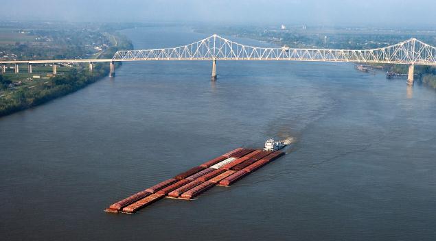
8 Make river transportation a known option within the emergency response transportation network Emergency Trans. Network -Highways -Air -Rail -Rivers *especially in moving bulk resources to outside Logistical Staging Areas
9 Focuses for Map Life Safety How to move resources in to save lives With a New Madrid Event, life safety issues will go past the typical 72 hour timeframe Focus Less on Fixing the Navigation Routes Federal agency jurisdiction to figure that out Platform will focus on the kind of information that State & Federal Emergency Managers will be requesting from Maritime-based Agencies


10 Reference Materials River Crossing Sheet Maritime Issues for a New Madrid Seismic Event Map Book

11
 -Dr.")
12 Initial Threat Description -Mr. Jim Wilkinson (CUSEC) -Dr. Randall Jibson (USGS)
13 Build a mapping platform based around what we already have & use Platform 1: Coast Guard Platform 2: Corps Nav. Platform 3: Corps EM Platform 4: Etc. PreCAP Platform Focus on Finding Existing shapefiles or datasets Ways to provide automatic or quick manual updates into our system Ways to easily interpret existing platform information to update the PreCAP Platform

14 Determined EEIs Started with 3, Moved to 11, and Ended with 8
15 Determined EEIs 1. Landslide/Ground Failures 2. River Mile Status 3. Port Status 4. Lock Status 5. Bridge & Other Crossing Status 6. Boat Ramp Status 7. Navigation Recovery Boat Status 8. Fueling Point Status

, Produced After Quake (Blank Field")
16 1. Landslide/Ground Failures Type of GIS Data: Layer Shapefiles Where Data From: USGS Soil Amplification Induced by Ground Motion Map Shakemap - Produced After Quake (Blank Field for Now) Slidemap - (In development), Produced After Quake (Blank Field for Now)

17 2. River Mile Status Type of GIS Data: Line Data Base GIS Data: USACE Navigable Inland Waterways Shapefile Status System: Red, Amber, Green, White Maintenance:??, Rivers Industry Executive Task Force, & Coast Guard Note: Believe this will be the hardest EEI for IT/GIS to Develop because we need a way to quickly update river statuses not on a mile by mile basis


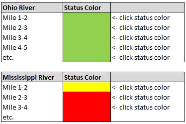
18 2. River Mile Status PRECAP


19 3. Port Status Type of GIS Data: Point Data Base GIS Data: USACE or Coast Guard Shapefile Status System: Red, Amber, Green, White Note: Only Track Major Ports, not individual Facilities Maintenance:??, Coast Guard provides status

20 4. Lock Status Type of GIS Data: Point Data Base GIS Data: USACE Shapefile Status System: Red, Amber, Green, White Maintenance:??, Corps provides status

21 5. Bridge & Other Crossing Status Type of GIS Data: Point Data Base GIS Data: Nav Charts Status System: Red, Amber, Green, White Maintenance:??
 Agencies Status System: Red, Amber, Green, White Maintenance:??, State Conservation (River) Agencies")
22 6. Boat Ramp Status Type of GIS Data: Point Data Base GIS Data: Will need to collect from State Conservation (River) Agencies Status System: Red, Amber, Green, White Maintenance:??, State Conservation (River) Agencies
 Status System: Red, Amber, Green, White")
23 7. Navigation Recovery Boat Status Type of GIS Data: Point Data Base GIS Data: Start Plotting After Disaster (Blank Field for Now) Status System: Red, Amber, Green, White Maintenance:??

24 8. Fueling Point Status Type of GIS Data: Point Data Base GIS Data: Will need to Collect from State Agriculture &/or Fire Marshall Status System: Red, Amber, Green, White Maintenance:??

25 Drop Down Box
B.2 Sources for Hazard Identification, Profiling, and Ranking (Section 3) Overview of Sussex County s History of Hazards
 Overview of Sussex County s History of Hazards") Appendix B Sources B.1 Sources for Planning Process (Section 2) FEMA. Mitigation Planning Guidance (386 Series). Available on the web at: http://www.fema.gov/plan/mitplanning/planning_resources.shtm FEMA
Appendix B Sources B.1 Sources for Planning Process (Section 2) FEMA. Mitigation Planning Guidance (386 Series). Available on the web at: http://www.fema.gov/plan/mitplanning/planning_resources.shtm FEMA
2018 NASCIO Award Submission Category: Cross-Boundary Collaboration and Partnerships. Project Title: Tennessee Wildfires: A Coordinated GIS Response
 2018 NASCIO Award Submission Category: Cross-Boundary Collaboration and Partnerships Project Title: Tennessee Wildfires: A Coordinated GIS Response Sevier County, Tennessee State of Tennessee, Emergency
National Waterway Network. Waterway Mile Marker Database. Waterway Network Link Commodity Data.
 National Waterway Network. Waterway Mile Marker Database. Waterway Network Link Commodity Data. Comments or Questions Contact: WCSC (504) 862-1424, or (504) 862-1441 http://www.iwr.usace.army.mil/about/technical-centers/wcsc-waterborne-commerce-statistics-center/
United States Multi-Hazard Early Warning System
 United States Multi-Hazard Early Warning System Saving Lives Through Partnership Lynn Maximuk National Weather Service Director, Central Region Kansas City, Missouri America s s Weather Enterprise: Protecting
Application of Geospatial Technology in an Emergency Management Academic Program
 Application of Geospatial Technology in an Emergency Management Academic Program Author Edwin Leachman Visiting Assistant Professor Department of Emergency Administration and Management Arkansas Tech University
3Chapter Three: Rescue and Response
 17 16 Report Science Title and the Storms: the USGS Response to the Hurricanes of 2005 3Chapter Three: Rescue and Response This chapter documents the U.S. Geological Survey s (USGS) humanitarian rescue
NC Emergency Management A View from the Counties
 NC Emergency Management A View from the Counties Amy Bason, NCACC Rocky Hyder, Henderson County Jeff Batten, Durham County Norman Bryson, Onslow County PARTNERSHIP Emergency Management efforts require
CITY OF RIVERSIDE USING HAZUS TO CREATE A EARTHQUAKE PLANNING GUIDE FOR A UNIFIED FIELD RESPONSE
 CITY OF RIVERSIDE USING HAZUS TO CREATE A EARTHQUAKE PLANNING GUIDE FOR A UNIFIED FIELD RESPONSE Presented by the Phil McCormick City of Riverside Office of Emergency Management HISTORY The City had several
USGS Hydrography Overview. May 9, 2018
 + 1 USGS Hydrography Overview May 9, 2018 + 2 The National Geospatial Program Provides the geospatial baseline of the Nation s topography, natural landscape and built environment through The National Map,
APPLICATIONS OF EARTHQUAKE HAZARD MAPS TO LAND-USE AND EMERGENCY PLANNING EXAMPLES FROM THE PORTLAND AREA
 APPLICATIONS OF EARTHQUAKE HAZARD MAPS TO LAND-USE AND EMERGENCY PLANNING EXAMPLES FROM THE PORTLAND AREA O. Gerald Uba Metro, Portland, Oregon OVERVIEW The extent to which we understand "below ground"
Statewide Topographic Mapping Program
 Statewide Topographic Mapping Program February 28, 2018 www.dotd.la.gov Outline Purpose of the Statewide Topographic Mapping Program History Breakdown of R.S. 48:36 - Topographic Mapping Statewide Topographic
Response Case Study: April 2014 Historic Flood Event. Severe Weather April 29 30, 2014
 Response Case Study: April 2014 Historic Flood Event NOAA s Regional Preparedness Training (NRPT) Natural Disaster Causing Technology Disasters in Mobile Bay Area Kimberly Albins Gulf of Mexico Regional
UTILIZING GIS IN NEXT GENERATION Tennessee Information for Public Safety. Presented by State of TN, OIR-GIS Services
 UTILIZING GIS IN NEXT GENERATION 9-1-1 Tennessee Information for Public Safety Presented by State of TN, OIR-GIS Services Next Generation 9-1-1 WHAT IT IS AND HOW IT WORKS Next Generation 9-1-1 IP (Internet
National Situation Report As of 3:00 a.m. EDT, Monday, October 2, 2017 Table of Contents Current Operations Monitoring Recovery
 Overview National Situation Report As of 3:00 a.m. EDT, Monday, October 2, 2017 Table of Contents Current Operations Monitoring Recovery FEMA Headquarters Status FEMA Region Status NRCC Level I (24/7)
Baldwin County, Alabama
 2015 Baldwin County, Alabama Multi-Hazard Mitigation Plan I. Comprehensive Plan A multi-jurisdiction plan City of Bay Minette City of Daphne Town of Elberta City of Fairhope City of Foley City of Gulf
Summary of Available Datasets that are Relevant to Flood Risk Characterization
 Inter-Agency Characterization Workshop February 25-27, 2014 USACE Institute for Water Resources, Alexandria, VA, IWR Classroom Summary of Available Datasets that are Relevant to Characterization National
IDENTIFICATION OF HAZARDS OF CONCERN
 IDENTIFICATION OF HAZARDS OF CONCERN To provide a strong foundation for mitigation strategies considered in Section 6, the Village considered a full range of hazards that could impact the area and then
GEOGRAPHIC INFORMATION SYSTEMS Session 8
 GEOGRAPHIC INFORMATION SYSTEMS Session 8 Introduction Geography underpins all activities associated with a census Census geography is essential to plan and manage fieldwork as well as to report results
2014 Annual Mitigation Plan Review Meeting
 2014 Annual Mitigation Plan Review Meeting Highland County EMA MEETING OBJECTIVES Understand Your Natural Disaster Risk Review of Previous Plans Current Plan Status Future Activity Plan/Needs of Each Community
Jefferson Parish GIS Hurricane Response Review. From the information given by A.J. Tapie, GIS Manager of Jefferson Parish, the use of
 Neil Dixon and Ryan Ziegelbauer URPL 969 3/10/2006 Jefferson Parish GIS Hurricane Response Review From the information given by A.J. Tapie, GIS Manager of Jefferson Parish, the use of GIS in the Parish
Hurricane Preparation and Recovery. October 11, 2011 Jon Nance, Chief Engineer, NCDOT
 Hurricane Preparation and Recovery October 11, 2011 Jon Nance, Chief Engineer, NCDOT North Carolina & Severe Weather Our state often bears the brunt of storms, which include: Ice storms Snow storms Heavy
geographic patterns and processes are captured and represented using computer technologies
 Proposed Certificate in Geographic Information Science Department of Geographical and Sustainability Sciences Submitted: November 9, 2016 Geographic information systems (GIS) capture the complex spatial
Inter State Large Navigable Rivers of the United States
 Inter State Large Navigable Rivers of the United States REVIEW OF NORTH AMERICAN BASINS: GREAT LAKES AND MISSISSIPPI RIVER HELEN A. BROHL, EXECUTIVE DIRECTOR US COMMITTEE ON THE MARINE TRANSPORTATION SYSTEM
The Use of Geographic Information Systems (GIS) by Local Governments. Giving municipal decision-makers the power to make better decisions
 by Local Governments. Giving municipal decision-makers the power to make better decisions") The Use of Geographic Information Systems (GIS) by Local Governments Giving municipal decision-makers the power to make better decisions Case Study: Examples of GIS Usage by Local Governments in North
The Use of Geographic Information Systems (GIS) by Local Governments Giving municipal decision-makers the power to make better decisions Case Study: Examples of GIS Usage by Local Governments in North
Coastal Response Research Center. Nancy Kinner University of New Hampshire (UNH) Michele Jacobi NOAA ORR. September 27, 2007
 Michele Jacobi NOAA ORR. September 27, 2007") Coastal Response Research Center Nancy Kinner University of New Hampshire (UNH) Michele Jacobi NOAA ORR September 27, 2007 1 Coastal Response Research Center (CRRC) CRRC is partnership between NOAA s Office
Coastal Response Research Center Nancy Kinner University of New Hampshire (UNH) Michele Jacobi NOAA ORR September 27, 2007 1 Coastal Response Research Center (CRRC) CRRC is partnership between NOAA s Office
Heather Schlosser Army Corps of Engineers Coastal Studies Group August 28, 2008
 Got sand? Regional Sediment Management in Orange County Heather Schlosser Army Corps of Engineers Coastal Studies Group August 28, 2008 Regional Sediment Management Regional sediment management recognizes
Marine Analysis. LA 23 New. Louisiana. Prepared by:
 Gulf Intracoastal Waterway (GIWW) Marine Vessel Trafficc Analysis LA 23 New Orleans Gulf Coastt Railway Relocation PE/NEPA Project Jefferson and Plaquemines Parishes, Louisiana RPC Task LA23RR1 RPC/FRA
A Broad View of Geospatial Technology & Systems
 A Broad View of Geospatial Technology & Systems Pete Large Vice President, Trimble On the shoulders of giants 1 Since their time, our ability to generate geospatial information has grown exponentially
From a Hurricane Evacuation Map Series to a 3D Analytical Approach to Emergency Response by SHA Road Maintenance Crews
 From a Hurricane Evacuation Map Series to a 3D Analytical Approach to Emergency Response by SHA Road Maintenance Crews Mike Sheffer Highway Information Services Division GIS Program Coordinator GIS-T T
Colorado Ice Jams and CRREL s Ice Jam Database CRREL Ice Engineering Group
 Colorado Ice Jams and CRREL s Ice Jam Database CRREL Ice Engineering Group Presented by, Carrie Vuyovich, Ph.D., P.E. Research Hydraulic Engineer ERDC Cold Regions Research and Engineering Laboratory,
INDOT Office of Traffic Safety
 Intro to GIS Spatial Analysis INDOT Office of Traffic Safety Intro to GIS Spatial Analysis INDOT Office of Traffic Safety Kevin Knoke Section 130 Program Manager Highway Engineer II Registered Professional
Table-Top Exercise for Emergency Preparedness Evaluation: Little Anse, Isle Madame
 Table-Top Exercise for Emergency Preparedness Evaluation: Little Anse, Isle Madame Alexander Chung, M.Sc. Candidate C-Change Student Research Associate May 2013 The Community of Little Anse Coastal community
Paul Bridge Meteorologist Vaisala/UKMO Work Groups/Committees: WMO/TRB/AMS
 Paul Bridge Meteorologist Vaisala/UKMO Work Groups/Committees: WMO/TRB/AMS Introduction (a) Identify and establish, if possible, inventories of transport networks in the ECE region which are vulnerable
Daily Operations Briefing Friday, February 7, :30 a.m. EST
 Daily Operations Briefing Friday, February 7, 2014 8:30 a.m. EST Significant Activity: February 6 7 Significant Events: Winter Weather Recovery Plains to Northeast Emergency Declaration (FEMA-3367-EM)
Report on the Damage Survey Caused by Hurricane Katrina (Tentative Report)
") Report on the Damage Survey Caused by Hurricane Katrina (Tentative Report) November 1, 2005 Coastal Disaster Prevention Technology Survey Team 1. Introduction Hurricane Katrina struck the United States
Report on the Damage Survey Caused by Hurricane Katrina (Tentative Report) November 1, 2005 Coastal Disaster Prevention Technology Survey Team 1. Introduction Hurricane Katrina struck the United States
THE STUDY ON 4S TECHNOLOGY IN THE COMMAND OF EARTHQUAKE DISASTER EMERGENCY 1
 THE STUDY ON 4S TECHNOLOGY IN THE COMMAND OF EARTHQUAKE DISASTER EMERGENCY 1 Zhou Wensheng 1, Huang Jianxi 2, Li Qiang 3, Liu Ze 3 1 Associate Professor, School of Architecture, Tsinghua University, Beijing.
Department: Emergency Management FY 2018/19 Proposed Budget
 Department: Emergency Management FY 2018/19 Proposed Budget Department Mission: The mission of Klamath County Emergency Management (EM) is to create an EM program that meets the requirements of ORS 401
STUDY GUIDE TABLE OF CONTENTS WITH REPORT EXHIBITS. LIST OF ACRONYMS...iv. OVERVIEW OF THE STUDY GUIDE...v SECTION I - PREPARATION AND TOOLS...
 STUDY GUIDE TABLE OF CONTENTS WITH REPORT EXHIBITS SUBJECT-SECTION SECTION-PAGE LIST OF ACRONYMS...iv OVERVIEW OF THE STUDY GUIDE...v SECTION I - PREPARATION AND TOOLS...1-1 SECTION II- FEDERAL SHORT RANGE
Borah Peak Earthquake HAZUS Scenario Project Executive Summary Idaho Bureau of Homeland Security Idaho Geological Survey Western States Seismic
 Borah Peak Earthquake HAZUS Scenario Project Executive Summary Idaho Bureau of Homeland Security Idaho Geological Survey Western States Seismic Policy Council 12/30/2008 The HAZUS-MH analysis of the Borah
Seth J. Wittke Wyoming State Geological Survey
 Seth J. Wittke Wyoming State Geological Survey Project initiation Data manipulation Scenarios Creating the IMS Lessons learned County-wide block level probabilistic models created in 2004 for state mitigation
Applications of GIS in management and planning
 Applications of GIS in management and planning 5th Interagency Social Science Roundtable Institute of Water Resources, U.S. Army Corps of Engineers Alexandria VA, January 10, 2011 US Army Corps of Engineers
The Tampa Bay Catastrophic Plan Presentation to CFGIS Users Group FDOT District 5 Urban Offices - Orlando July 30, 2010
 The Tampa Bay Catastrophic Plan Presentation to CFGIS Users Group FDOT District 5 Urban Offices - Orlando July 30, 2010 Brady Smith Senior Planner Tampa Bay Regional Planning Council Introduction Recent
The Indiana Data Sharing Initiative and the IndianaMap. Cross-Boundary Collaboration and Partnerships. State of Indiana
 The Indiana Data Sharing Initiative and the IndianaMap Cross-Boundary Collaboration and Partnerships State of Indiana Brian Arrowood, CIO James Sparks, GIO EXECUTIVE SUMMARY Under the collaboration oriented
STEUBEN COUNTY, NEW YORK. Hazard Analysis Report
 STEUBEN COUNTY, NEW YORK Hazard Analysis Report Prepared by: April 1, 2014 Background On April 1, 2014 the Steuben County Office of Emergency Management conducted a hazard analysis using the automated
March 11, 2011 Japanese Tsunami
 John Fassell March 11, 2011 Japanese Tsunami An earthquake occurred 30 miles under ground which lifted the seafloor Incoming wave as seen from shore Tsunami up to 130 feet tall in Miyako, JA that averaged
Law Enforcement Solutions and Applications
 ArcGIS for Solutions and Applications Solutions and Applications ArcGIS for Platform ArcGIS for Collection of solutions and applications for law enforcement. Built on the ArcGIS platform. For any named
Collaboration, Automation & Foundation Data: three steps towards spatially enabled government **
 ADVANCE UNEDITED VERSION UNITED NATIONS E/CONF.103/25 ECONOMIC AND SOCIAL COUNCIL Tenth United Nations Regional Cartographic Conference for the Americas New York, 19-23, August 2013 Item 6 (a) of the provisional
HURREVAC The software Tool used by emergency officials for hurricane evacuation assistance
 HURREVAC 2010 A Quick Reference enc e Guide The software Tool used by emergency officials for hurricane evacuation assistance www.hurrevac.com FinalHURREVAC2010Guide.indd 1 About HURREVAC HURREVAC is a
City of Saginaw Right of Way Division Snow and Ice Removal Policy January 18, 2016
 Snow and Ice Removal Policy January 18, 2016 It is the policy of the to provide snowplowing and ice removal services in order to: Provide safe traveling conditions for motorists and pedestrians Assist
West Hollywood General Plan
 ITEM 2.RR. EXHIBIT B Providing a safe living environment is a fundamental goal and one of the most important challenges cities face today. Anticipating, planning for, and guarding against threats to public
SITUATION REPORT #7 September 8 th, 2017
 MCO AIRPORT EMERGENCY OPERATIONS CENTER SITUATION REPORT #7 September 8 th, 2017 STATE OF FLORIDA REGION V FEMA REGION IV GENERAL INFORMATION Local State of Emergency Declaration Number: 17-235 Dated:
Real-Time Flood Forecasting Modeling in Nashville, TN utilizing HEC-RTS
 Real-Time Flood Forecasting Modeling in Nashville, TN utilizing HEC-RTS Brantley Thames, P.E. Hydraulic Engineer, Water Resources Section Nashville District, USACE August 24, 2017 US Army Corps of Engineers
Environmental Response Management Application
 Environmental Response Management Application Coastal Response Research Center Nancy Kinner, Michele Jacobi, Rob Braswell, Kurt Schwehr & Amy Merten RRT III May 14, 2008 1 Talk Outline Overview of Center
Geographic Information Systems(GIS)
") Geographic Information Systems(GIS) Threat Analysis Techniques Overview What is GIS? Functional capabilities of GIS BCM Process and GIS How to leverage GIS in threat/risk analysis Ron Brown, CBCP Managing
Geographic Information Systems(GIS) Threat Analysis Techniques Overview What is GIS? Functional capabilities of GIS BCM Process and GIS How to leverage GIS in threat/risk analysis Ron Brown, CBCP Managing
Internet GIS Sites. 2 OakMapper webgis Application
 Internet GIS Sites # Name URL Description 1 City of Sugar Land http://www.sugarlandtx.gov/index.htm It is a city in Texas with 65,000 Residents. The City of Sugar Land, Texas, provides ArcIMS-based maps
Comprehensive Emergency Management Plan
 Comprehensive Emergency Management Plan Section 6-Earthquake Annex Blank Intentionally 2 CEMP Annex 6 1 Earthquake Annex I. PURPOSE II. SITUATION The earthquake annex is a hazard-specific annex to be used
STEREO ANALYST FOR ERDAS IMAGINE Stereo Feature Collection for the GIS Professional
 STEREO ANALYST FOR ERDAS IMAGINE Stereo Feature Collection for the GIS Professional STEREO ANALYST FOR ERDAS IMAGINE Has Your GIS Gone Flat? Hexagon Geospatial takes three-dimensional geographic imaging
New USGS Maps Identify Potential Ground- Shaking Hazards in 2017
 New USGS Maps Identify Potential Ground- Shaking Hazards in 2017 New USGS Maps Identify Potential Ground-Shaking Hazards in 2017 The central U.S. faces continued hazards from human-induced earthquakes
Surviving the Big One: Understanding and Preparing for a Major Earthquake in Western Oregon
 Surviving the Big One: Understanding and Preparing for a Major Earthquake in Western Oregon May 21, 2013 City of Salem Salem Public Library Althea Rizzo, Geological Hazards Program Coordinator Oregon Emergency
5.2. IDENTIFICATION OF NATURAL HAZARDS OF CONCERN
 5.2. IDENTIFICATION OF NATURAL HAZARDS OF CONCERN To provide a strong foundation for mitigation strategies considered in Sections 6 and 9, County considered a full range of natural hazards that could impact
VISIT MISSISSIPPI GULF COAST CRISIS COMMUNICATION MANUAL 2016
 VISIT MISSISSIPPI GULF COAST CRISIS COMMUNICATION MANUAL 2016 This manual was prepared for Visit Mississippi Gulf Coast staff in the event of a crisis, and will help to distinguish the appropriate course
WESTERN STATES SEISMIC POLICY COUNCIL POLICY RECOMMENDATION Earthquake and Tsunami Planning Scenarios
 WESTERN STATES SEISMIC POLICY COUNCIL POLICY RECOMMENDATION 18-1 Earthquake and Tsunami Planning Scenarios Policy Recommendation 18-1 WSSPC strongly encourages states, provinces, territories, First Nations,
2014 San Gabriel Valley Water Forum. October 2, 2014
 2014 San Gabriel Valley Water Forum October 2, 2014 Panel 3 Are we Ready? Flooding, Fires and Earthquakes Don Boland, California Utilities Emergency Association Southern California Catastrophic Earthquake
University of New Hampshire Scholars' Repository
 University of New Hampshire University of New Hampshire Scholars' Repository Center for Coastal and Ocean Mapping Center for Coastal and Ocean Mapping 3-2009 Environmental Response Management Application
State-of-the-Art GIS as an Integrating Technology
 Paper # 104: GIS for Oil Spill Prevention & Response Devon Humphrey Instructor, National Spill Control School Texas A&M University at Corpus Christi, TX Introduction and History The National Spill Control
Crystal Goodison & Alexis Thomas University of Florida GeoPlan Center
 Crystal Goodison & Alexis Thomas University of Florida GeoPlan Center A1A Fort Lauderdale, Hurricane Sandy, October 2012 Photo Credits: Susan Stocker, Sun Sentinel FAU s Research Report (completed Jan
National Situation Report As of 3:00 a.m. EDT, Sunday, October 8, 2017 Table of Contents Current Operations Monitoring Recovery
 Overview National Situation Report As of 3:00 a.m. EDT, Sunday, October 8, 2017 Table of Contents Current Operations Monitoring Recovery FEMA Headquarters Status FEMA Region Status NRCC Level I (24/7)
State of Georgia Snow and Ice Plan
 State of Georgia Snow and Ice Plan Annex to: Georgia Emergency Operations Plan 2013 The State of Georgia Snow and Ice Plan contains information needed by local and state planners and response personnel.
Integrated Geodatabase Model for effective planning of District -Hamirpur
 Integrated Geodatabase Model for effective planning of District -Hamirpur Developed by District Administration,Hamirpur in collaboration with Centre for Geoinformatics Research and Training, CSK HPAU,Palampur
CREATING USACE SPATIAL DATA STANDARDS-COMPLIANT GEODATABASES FOR STORAGE AND RETRIEVAL OF SPATIALLY REFERENCED DREDGE MATERIAL ANALYTICAL RESULTS
 CREATING USACE SPATIAL DATA STANDARDS-COMPLIANT GEODATABASES FOR STORAGE AND RETRIEVAL OF SPATIALLY REFERENCED DREDGE MATERIAL ANALYTICAL RESULTS Christine Smith 1, Nadia Lombardero 2, and Philip M. Wolf
Transforming the Maricopa County Department of Transportation (MCDOT) GIS-based Transportation Asset Inventory System June 30, 2016
 GIS-based Transportation Asset Inventory System June 30, 2016") Transforming the Maricopa County Department of Transportation (MCDOT) GIS-based Transportation Asset Inventory System June 30, 2016 Presented By Steve Hossack, GIS Database Administrator 2016 Esri User
Transforming the Maricopa County Department of Transportation (MCDOT) GIS-based Transportation Asset Inventory System June 30, 2016 Presented By Steve Hossack, GIS Database Administrator 2016 Esri User
PRE MONSOON TROPICAL CYCLONE ALERT (LAILA)
") PRE MONSOON TROPICAL CYCLONE ALERT (LAILA) (Updated as on 19 th May, 2010, 10.00 AM) A pre-monsoon Tropical Cyclone alert has been issued for all the coastal districts of Orissa by the Special Relief Commissioner
PRE MONSOON TROPICAL CYCLONE ALERT (LAILA) (Updated as on 19 th May, 2010, 10.00 AM) A pre-monsoon Tropical Cyclone alert has been issued for all the coastal districts of Orissa by the Special Relief Commissioner
Maritime Weather Information: Automatic Reporting, A New Paradigm
 Maritime Weather Information: Automatic Reporting, A New Paradigm Joe Sienkiewicz, NOAA/NWS Ocean Prediction Center Responsibilities under SOLAS Met Services Contracting governments Observations Limited
May 31, Flood Response Overview
 May 31, 2013 Flood Response Overview Suppression 867 Personnel on three (3) shifts 289 Red Shift (A) 289 Blue Shift (B) 289 Green Shift (C) Department Overview Department Overview EMS: 40,934 False Alarm:
why is a national or regional context important?
 The need Accessibility to opportunities, Efficient movement of people and goods, Environmental Health Strength and competitiveness of the economy, Availability and cost of energy, Safety and Security,
StreamStats: Delivering Streamflow Information to the Public. By Kernell Ries
 StreamStats: Delivering Streamflow Information to the Public By Kernell Ries U.S. Department of the Interior U.S. Geological Survey MD-DE-DC District 410-238-4317 kries@usgs.gov StreamStats Web Application
Fort Lauderdale s GIS Supports Response to. Hurricane Irma
 Fort Lauderdale s GIS Supports Response to Hurricane Irma By Monica Pratt, ArcUser Editor When Hurricane Irma first made landfall in the Florida Keys on September 10, 2017, it brought destructive 70 mph
Weather Information for Surface Transportation (WIST): Update on Weather Impacts and WIST Progress
: Update on Weather Impacts and WIST Progress") Weather Information for Surface Transportation (WIST): Update on Weather Impacts and WIST Progress Samuel P. Williamson Office of the Federal Coordinator for Meteorological Services and Supporting Research
Weather Information for Surface Transportation (WIST): Update on Weather Impacts and WIST Progress Samuel P. Williamson Office of the Federal Coordinator for Meteorological Services and Supporting Research
MODERNIZATION OF THE MUNICIPAL MAPPING USING HIGH END GNSS SYSTEM AND GIS SOFTWARE
 MODERNIZATION OF THE MUNICIPAL MAPPING USING HIGH END GNSS SYSTEM AND GIS SOFTWARE Mr. R. A. R. Khan Assistant Engineer, Sewerage Utility Management Centre (SUMC) Municipal Corporation Of Greater Mumbai
Folsom Dam Water Control Manual Update
 Folsom Dam Water Control Manual Update Public Workshop April 3, 2014 Location: Sterling Hotel Ballroom 1300 H Street, Sacramento US Army Corps of Engineers BUILDING STRONG WELCOME & INTRODUCTIONS 2 BUILDING
Status and Challenges on Geo-DRM Information Systems in Tonga
 Name: Mafua- i-vai utukakau Maka Status and Challenges on Geo-DRM Information Systems in Tonga 1 Roles and Relationships Land and Geographic Information Systems (LGIS) Unit: Establish updated high-resolution
Smart Flood Risk Management Solutions
 Smart Flood Risk Management Solutions - RHDHV s Experience in the Gulf of Mexico Mathijs van Ledden, Marten Hillen and Ries Kluskens Challenge Extreme weather around the world (hurricanes, cyclones, extratropical
NOAA Surface Weather Program
 NOAA Surface Weather Program Maintenance Decision Support System Stakeholder Meeting #9 Jim O Sullivan NOAA Surface Weather Program Manager NWS Office of Climate, Water, and Weather Services September
GIS Emergency Management for the University of Redlands
 GIS Emergency Management for the University of Redlands ESRI International User Conference 2003 Paper Submission Paper Number: 1178 By: Kevin Johnson Abstract In times of crisis, the President and other
Geographic Information System Services. Strategic Plan FY
 Geographic Information System Services Strategic Plan FY 2011 2012 Drafted by: Gary Palmer, Assistant Town Manager Major Sections: History Mission, Vision, Values Strategic Issues Performance Measurement
BookletChart. Intracoastal Waterway Bahia Honda Key to Sugarloaf Key NOAA Chart A reduced-scale NOAA nautical chart for small boaters
 BookletChart Intracoastal Waterway Bahia Honda Key to Sugarloaf Key NOAA Chart 11445 A reduced-scale NOAA nautical chart for small boaters When possible, use the full-size NOAA chart for navigation. Published
Red River Levee Panel
 Red River Levee Panel Mississippi River Commission Monday, August 9, 2017 Red River Levees in LA & AR NONE along TX & OK Boarder Red River Levee Issues Caddo Levee Cherokee Park Authorization Bossier Levee
Responders Organized for Pass Emergencies (ROPE)
") Responders Organized for Pass Emergencies (ROPE) Miles H. Wagner Emergency Services Officer San Bernardino County Fire Department Office of Emergency Services Mark A. Hartwig Fire Chief/Fire Warden ROPE
Responders Organized for Pass Emergencies (ROPE) Miles H. Wagner Emergency Services Officer San Bernardino County Fire Department Office of Emergency Services Mark A. Hartwig Fire Chief/Fire Warden ROPE
HURRICANE MATTHEW A GIS PERSPECTIVE GLYNN COUNTY GIS
 HURRICANE MATTHEW A GIS PERSPECTIVE GLYNN COUNTY GIS Situation September 25 th October 9 th 2016 Hurricane Matthew tracked its way up the east coast bringing hurricane force winds and flooding from Haiti
Comprehensive Emergency Management Plan
 Comprehensive Emergency Management Plan Section 6- Severe Weather/Wildfire Annex Blank Intentionally 2 CEMP Annex 6 11 Severe Weather / Wildfire Annex I. PURPOSE This plan outlines the procedures to be
HEC & GIS Modeling of the Brushy Creek HEC & GIS Watershed Modeling of the
 HEC & GIS Modeling of the Brushy Creek HEC & GIS Watershed Modeling of the By Cassandra Fagan 5, December 2014 http://ubcwatershedstudy.ursokr.com/images/ Contents Introduction... 3 Figure 1: 24-hour rainfall
Managing an Extreme Weather Event of Prolonged Duration May 22, 2013
 Managing an Extreme Weather Event of Prolonged Duration May 22, 2013 MISSOURI RIVER FLOOD OF 2011 M I C H A E L J. K E N N E R L Y P. E. D I R E C T O R O F T H E O F F I C E O F D E S I G N I O W A D
Copernicus Overview. Major Emergency Management Conference Athlone 2017
 Copernicus Overview Major Emergency Management Conference Athlone 2017 Copernicus is a European programme implemented by the European Commission. The services address six thematic areas: land, marine,
"The Big One" by sea and not by land
 "The Big One" by sea and not by land By Los Angeles Times, adapted by Newsela staff on 03.24.14 Word Count 629 Surfer Lee Johnson emerges from the water at San Onofre State Beach, Calif., with the twin
Maricopa County Department of Transportation (MCDOT) GIS Innovations in Transportation Asset Management
 GIS Innovations in Transportation Asset Management") Maricopa County Department of Transportation (MCDOT) GIS Innovations in Transportation Asset Management Presented By Steve Hossack, GIS Database Administrator 2018 ITE/IMSA Spring Conference Maricopa County
Maricopa County Department of Transportation (MCDOT) GIS Innovations in Transportation Asset Management Presented By Steve Hossack, GIS Database Administrator 2018 ITE/IMSA Spring Conference Maricopa County
ASFPM - Rapid Floodplain Mapping
 ASFPM - Nicole Cominoli Hydraulic Engineer USACE - Omaha District mary.n.cominoli@usace.army.mil June 3, 2015 US Army Corps of Engineers Mitigation = Risk Informed Decisions 2 The National Flood Insurance
Applied Geoscience and Technology Division SOPAC. Joy Papao, Risk Information Systems Officer
 Joy Papao, Risk Information Systems Officer Secretariat of the Pacific Community SPC 22 Pacific Island States Head office in Noumea, New Caledonia 2 Regional offices (Pohnpei and Honiara) 600 staff 9 Technical
STATE GEOGRAPHIC INFORMATION DATABASE
 STATE GEOGRAPHIC INFORMATION DATABASE Data Information and Knowledge Management STATE GEOGRAPHIC INFORMATION DATABASE EXECUTIVE SUMMARY Utah has developed one of the most comprehensive statewide GIS resources
3D Elevation Program, Lidar in Missouri. West Central Regional Advanced LiDAR Workshop Ray Fox
 3D Elevation Program, Lidar in Missouri West Central Regional Advanced LiDAR Workshop Ray Fox National Enhanced Elevation Assessment (Dewberry, 2011) Sponsored by the National Digital Elevation Program
WINTER STORM Annex II
 WINTER STORM Annex II I. PURPOSE A. This annex has been prepared to ensure a coordinated response by state agencies to requests from local jurisdictions to reduce potential loss of life and to ensure essential