A Standardized Digital Well-Record Database for the Glaciated U.S.
|
|
|
- Adelia Elliott
- 5 years ago
- Views:
Transcription

1 A Standardized Digital Well-Record Database for the Glaciated U.S. Randy Bayless and Les Arihood U.S. Geological Survey, Indiana Water Science Center, Indianapolis, IN Howard Reeves U.S. Geological Survey, Michigan Water Science Center, Lansing, MI Randy Ulery and Gary Martin U.S. Geological Survey, Kentucky Water Science Center, Louisville, KY U.S. Department of the Interior U.S. Geological Survey

2 Background Arc Macro Language (AML) programs were developed by Les Arihood The AMLs were used to build several groundwater models Arihood, L.D Processing, analysis, and general evaluation of well-driller Logs for estimating hydrogeologic parameters of the glacial sediments in a ground-water flow model of the Lake Michigan basin: USGS SIR
3 Project Goals Create a sanitized and standardized database of digital well records for the glaciated U.S. Create Arc grid maps of Total unconsolidated thickness Total sand and gravel thickness Horizontal hydraulic conductivity Vertical hydraulic conductivity Transmissivity First Water
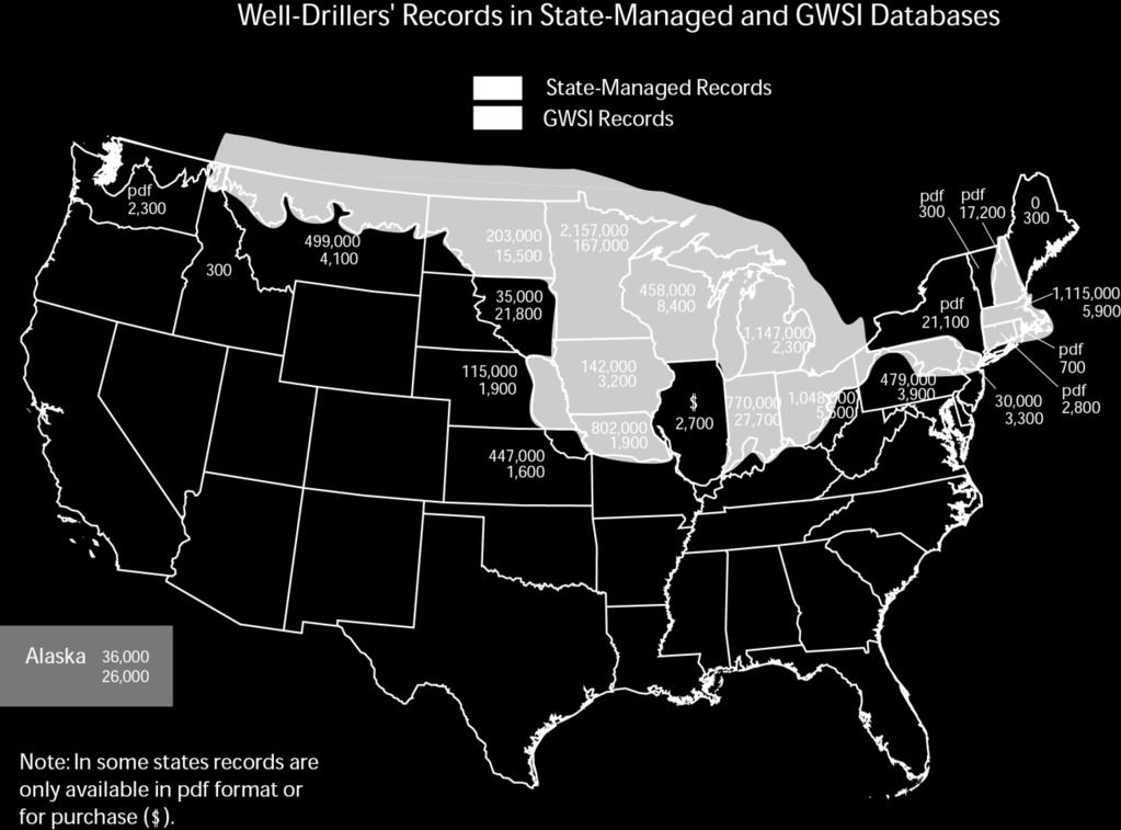
4 Databases Well-Drillers' Records Well-Drillers' Records GWSI State GWSI State State Records Records State Records Records Alaska 26,620 36,203 Nebraska 1, ,980 Connecticut 2,865 New Hampshire 17,221 0 Idaho ,944 New Jersey 3,323 30,275 Illinois 2,700 New York 21,192 Indiana 27, ,000 North Dakota 15, ,044 Iowa 3, ,626 Ohio 5,512 2,246,000 Kansas 1, ,508 Pennsylvania 3, ,626 Massachusetts 5,941 1,115,237 Rhode Island 784 Maine South Dakota 21,879 Michigan 2,393 1,147,000 Vermont Minnesota 167,847 2,157,441 Washington 2,380 Missouri 1, ,216 Wisconsin 8, ,875 Montana 4, ,519 TOTAL 247,872 11,111,438 Available for purchase Available as pdf only

5 Anticipated Lithologic Coverage
6 General Info and Lithologic Files General Well-Record Information Lithologic Information Site ID Location Land-Surface Elevation Water-Table Elevation Construction Date Well Construction Pump Test Intended Use Site ID Interval Tops Interval Bottoms Lithologies
7 Generalized Procedure Acquire Logs Convert Well- Drillers Descriptions to GWSI Compute Total Sand & Gravel Thickness Remove Incomplete Records Assign Coarse / Fine Estimate Kh, Kz, & T Reformat Records Remove Lithologic Illogical Records Compute K from Specific Capacity Data Remove Poorly Located Records Estimate Total Thickness Krig and Map the Hydraulic Properties
8 Translating and Standardizing Driller s Description sand and gravel S&G sand and grvl grey sand gravel grey sand gravel clay grey sand gravel clay and silt clay with silt sand and gravel Interpreted GWSI Lithology SDGL SDGL SDGL SDGL SGVC SGVC CLSD

9 Common Situations
10 Quality Evaluations Groundwater Atlas of the U.S. [ Widely Recognized Maps Bedrock surface by D. Soller Bedrock surface by Williston Study Group Ohio county study of aquifer transmissivity distribution based on county geology maps.


11 Comparing Maps Fig. 9 Major Aquifers USGS HA 730-M Well sites in the Standardized Well-Record Database

12 Comparing Maps Fig. 25 Unconsolidated Aquifers USGS HA 730-I Sand and Gravel Thickness Well-Record Database

13 Comparing Maps Fig. 30 Unconsolidated Thickness USGS HA 730-K Unconsolidated Thickness Well-Record Database

14 Comparing Maps


15 Concurrent Applications USGS National Cancer Institute: Statistical model to identify factors contributing to high-risk areas. USGS Williston Powder River Basin WUA: Groundwater model in region of enhanced petroleum recovery. National Water-Quality Assessment: Water quality characterization of the glaciated U.S.


16 Anticipated Products Total unconsolidated thickness Total sand and gravel thickness Relative horizontal K Relative vertical K Specific capacity horizontal K Aquifer transmissivity First Water Bedrock Surface

17 Anticipated Products Web served: Report Database Maps Interactive Storage Water-use

18 Final Remarks Map products are for large scale projects Database will be useful for small scale efforts Comments welcome!
19
, District of Columbia
 State Capitals These are the State Seals of each state. Fill in the blank with the name of each states capital city. (Hint: You may find it helpful to do the word search first to refresh your memory.),
Standard Indicator That s the Latitude! Students will use latitude and longitude to locate places in Indiana and other parts of the world.
 Standard Indicator 4.3.1 That s the Latitude! Purpose Students will use latitude and longitude to locate places in Indiana and other parts of the world. Materials For the teacher: graph paper, globe showing
New Educators Campaign Weekly Report
 Campaign Weekly Report Conversations and 9/24/2017 Leader Forms Emails Collected Text Opt-ins Digital Journey 14,661 5,289 4,458 7,124 317 13,699 1,871 2,124 Pro 13,924 5,175 4,345 6,726 294 13,086 1,767
Jakarta International School 6 th Grade Formative Assessment Graphing and Statistics -Black
 Jakarta International School 6 th Grade Formative Assessment Graphing and Statistics -Black Name: Date: Score : 42 Data collection, presentation and application Frequency tables. (Answer question 1 on
Challenge 1: Learning About the Physical Geography of Canada and the United States
 60ºN S T U D E N T H A N D O U T Challenge 1: Learning About the Physical Geography of Canada and the United States 170ºE 10ºW 180º 20ºW 60ºN 30ºW 1 40ºW 160ºW 50ºW 150ºW 60ºW 140ºW N W S E 0 500 1,000
Preview: Making a Mental Map of the Region
 Preview: Making a Mental Map of the Region Draw an outline map of Canada and the United States on the next page or on a separate sheet of paper. Add a compass rose to your map, showing where north, south,
Hourly Precipitation Data Documentation (text and csv version) February 2016
 February 2016") I. Description Hourly Precipitation Data Documentation (text and csv version) February 2016 Hourly Precipitation Data (labeled Precipitation Hourly in Climate Data Online system) is a database that gives
I. Description Hourly Precipitation Data Documentation (text and csv version) February 2016 Hourly Precipitation Data (labeled Precipitation Hourly in Climate Data Online system) is a database that gives
Correction to Spatial and temporal distributions of U.S. winds and wind power at 80 m derived from measurements
 JOURNAL OF GEOPHYSICAL RESEARCH, VOL. 109,, doi:10.1029/2004jd005099, 2004 Correction to Spatial and temporal distributions of U.S. winds and wind power at 80 m derived from measurements Cristina L. Archer
A. Geography Students know the location of places, geographic features, and patterns of the environment.
 Learning Targets Elementary Social Studies Grade 5 2014-2015 A. Geography Students know the location of places, geographic features, and patterns of the environment. A.5.1. A.5.2. A.5.3. A.5.4. Label North
SHAWN NAYLOR. Research Hydrogeologist Center for Geospatial Data Analysis, Indiana Geological Survey
 SHAWN NAYLOR Research Hydrogeologist Center for Geospatial Data Analysis, Indiana Geological Survey Project overview Funded by American Recovery and Reinvestment Act Develop distributed network of databases
Additional VEX Worlds 2019 Spot Allocations
 Overview VEX Worlds 2019 Spot s Qualifying spots for the VEX Robotics World Championship are calculated twice per year. On the following table, the number in the column is based on the number of teams
Summary of Natural Hazard Statistics for 2008 in the United States
 Summary of Natural Hazard Statistics for 2008 in the United States This National Weather Service (NWS) report summarizes fatalities, injuries and damages caused by severe weather in 2008. The NWS Office
Abortion Facilities Target College Students
 Target College Students By Kristan Hawkins Executive Director, Students for Life America Ashleigh Weaver Researcher Abstract In the Fall 2011, Life Dynamics released a study entitled, Racial Targeting
LABORATORY REPORT. If you have any questions concerning this report, please do not hesitate to call us at (800) or (574)
 or (574)") LABORATORY REPORT If you have any questions concerning this report, please do not hesitate to call us at (800) 332-4345 or (574) 233-4777. This report may not be reproduced, except in full, without written
LABORATORY REPORT If you have any questions concerning this report, please do not hesitate to call us at (800) 332-4345 or (574) 233-4777. This report may not be reproduced, except in full, without written
QF (Build 1010) Widget Publishing, Inc Page: 1 Batch: 98 Test Mode VAC Publisher's Statement 03/15/16, 10:20:02 Circulation by Issue
 Widget Publishing, Inc Page: 1 Batch: 98 Test Mode VAC Publisher's Statement 03/15/16, 10:20:02 Circulation by Issue") QF 1.100 (Build 1010) Widget Publishing, Inc Page: 1 Circulation by Issue Qualified Non-Paid Circulation Qualified Paid Circulation Individual Assoc. Total Assoc. Total Total Requester Group Qualified
QF 1.100 (Build 1010) Widget Publishing, Inc Page: 1 Circulation by Issue Qualified Non-Paid Circulation Qualified Paid Circulation Individual Assoc. Total Assoc. Total Total Requester Group Qualified
LABORATORY REPORT. If you have any questions concerning this report, please do not hesitate to call us at (800) or (574)
 or (574)") LABORATORY REPORT If you have any questions concerning this report, please do not hesitate to call us at (800) 332-4345 or (574) 233-4777. This report may not be reproduced, except in full, without written
LABORATORY REPORT If you have any questions concerning this report, please do not hesitate to call us at (800) 332-4345 or (574) 233-4777. This report may not be reproduced, except in full, without written
A method for three-dimensional mapping, merging geologic interpretation, and GIS computation
 A method for three-dimensional mapping, merging geologic interpretation, and GIS computation Soller, David R., U.S. Geological Survey, 908 National Center, Reston, VA 20192 and Richard C. Berg, Illinois
Harvey Thorleifson, Director, Minnesota Geological Survey. Status of geological mapping needed for groundwater protection in Minnesota
 Harvey Thorleifson, Director, Minnesota Geological Survey Status of geological mapping needed for groundwater protection in Minnesota Minnesota is located between the Dakotas and Wisconsin, north of Iowa,
What Lies Beneath: A Sub- National Look at Okun s Law for the United States.
 What Lies Beneath: A Sub- National Look at Okun s Law for the United States. Nathalie Gonzalez Prieto International Monetary Fund Global Labor Markets Workshop Paris, September 1-2, 2016 What the paper
Multivariate Statistics
 Multivariate Statistics Chapter 6: Cluster Analysis Pedro Galeano Departamento de Estadística Universidad Carlos III de Madrid pedro.galeano@uc3m.es Course 2017/2018 Master in Mathematical Engineering
Printable Activity book
 Printable Activity book 16 Pages of Activities Printable Activity Book Print it Take it Keep them busy Print them out Laminate them or Put them in page protectors Put them in a binder Bring along a dry
Online Appendix: Can Easing Concealed Carry Deter Crime?
 Online Appendix: Can Easing Concealed Carry Deter Crime? David Fortunato University of California, Merced dfortunato@ucmerced.edu Regulations included in institutional context measure As noted in the main
Multivariate Statistics
 Multivariate Statistics Chapter 4: Factor analysis Pedro Galeano Departamento de Estadística Universidad Carlos III de Madrid pedro.galeano@uc3m.es Course 2017/2018 Master in Mathematical Engineering Pedro
Crop Progress. Corn Mature Selected States [These 18 States planted 92% of the 2017 corn acreage]
![Crop Progress. Corn Mature Selected States [These 18 States planted 92% of the 2017 corn acreage]](/thumbs/89/98128758.jpg "Crop Progress. Corn Mature Selected States [These 18 States planted 92% of the 2017 corn acreage]") Crop Progress ISSN: 00 Released October, 0, by the National Agricultural Statistics Service (NASS), Agricultural Statistics Board, United s Department of Agriculture (USDA). Corn Mature Selected s [These
Crop Progress ISSN: 00 Released October, 0, by the National Agricultural Statistics Service (NASS), Agricultural Statistics Board, United s Department of Agriculture (USDA). Corn Mature Selected s [These
North American Geography. Lesson 2: My Country tis of Thee
 North American Geography Lesson 2: My Country tis of Thee Unit Overview: As students work through the activities in this unit they will be introduced to the United States in general, different regions
High School World History Cycle 2 Week 2 Lifework
 Name: Advisory: Period: High School World History Cycle 2 Week 2 Lifework This packet is due Monday, November 7 Complete and turn in on Friday for 10 points of EXTRA CREDIT! Lifework Assignment Complete
Office of Special Education Projects State Contacts List - Part B and Part C
 Office of Special Education Projects State Contacts List - Part B and Part C Source: http://www.ed.gov/policy/speced/guid/idea/monitor/state-contactlist.html Alabama Customer Specialist: Jill Harris 202-245-7372
Multivariate Statistics
 Multivariate Statistics Chapter 3: Principal Component Analysis Pedro Galeano Departamento de Estadística Universidad Carlos III de Madrid pedro.galeano@uc3m.es Course 2017/2018 Master in Mathematical
Finding Large Capacity Groundwater Supplies for Irrigation
 Finding Large Capacity Groundwater Supplies for Irrigation December 14, 2012 Presented by: Michael L. Chapman, Jr., PG Irrigation Well Site Evaluation Background Investigation Identify Hydrogeologic Conditions
JAN/FEB MAR/APR MAY/JUN
 QF 1.100 (Build 1010) Widget Publishing, Inc Page: 1 Circulation Breakdown by Issue Qualified Non-Paid Qualified Paid Previous This Previous This Total Total issue Removals Additions issue issue Removals
Meteorology 110. Lab 1. Geography and Map Skills
 Meteorology 110 Name Lab 1 Geography and Map Skills 1. Geography Weather involves maps. There s no getting around it. You must know where places are so when they are mentioned in the course it won t be
2005 Mortgage Broker Regulation Matrix
 2005 Mortgage Broker Regulation Matrix Notes on individual states follow the table REG EXEMPTIONS LIC-EDU LIC-EXP LIC-EXAM LIC-CONT-EDU NET WORTH BOND MAN-LIC MAN-EDU MAN-EXP MAN-EXAM Alabama 1 0 2 0 0
How to Identify and Properly Classify Drill Cuttings
 How to Identify and Properly Classify Drill Cuttings (Creating Useful Borehole Logs) Dave Larson Hydrogeology and Geophysics Section Accurate information about the borehole location and a careful description
Alpine Funds 2017 Tax Guide
 Alpine s 2017 Guide Alpine Dynamic Dividend ADVDX 1/30/17 1/31/17 1/31/17 0.020000000 0.019248130 0.000000000 0.00000000 0.019248130 0.013842273 0.000000000 0.000000000 0.000751870 0.000000000 0.00 0.00
Osteopathic Medical Colleges
 Osteopathic Medical Colleges Matriculants by U.S. States and Territories Entering Class 0 Prepared by the Research Department American Association of Colleges of Osteopathic Medicine Copyright 0, AAM All
Alpine Funds 2016 Tax Guide
 Alpine s 2016 Guide Alpine Dynamic Dividend ADVDX 01/28/2016 01/29/2016 01/29/2016 0.020000000 0.017621842 0.000000000 0.00000000 0.017621842 0.013359130 0.000000000 0.000000000 0.002378158 0.000000000
OUT-OF-STATE 965 SUBTOTAL OUT-OF-STATE U.S. TERRITORIES FOREIGN COUNTRIES UNKNOWN GRAND TOTAL
 Report ID: USSR8072-V3 Page No. 1 Jurisdiction: ON-CAMPUS IL Southern Illinois University - Carb 1 0 0 0 Black Hawk College Quad-Cities 0 0 1 0 John A Logan College 1 0 0 0 Rend Lake College 1 0 0 0 Aurora
RELATIONSHIPS BETWEEN THE AMERICAN BROWN BEAR POPULATION AND THE BIGFOOT PHENOMENON
 RELATIONSHIPS BETWEEN THE AMERICAN BROWN BEAR POPULATION AND THE BIGFOOT PHENOMENON ETHAN A. BLIGHT Blight Investigations, Gainesville, FL ABSTRACT Misidentification of the American brown bear (Ursus arctos,
MINERALS THROUGH GEOGRAPHY
 MINERALS THROUGH GEOGRAPHY INTRODUCTION Minerals are related to rock type, not political definition of place. So, the minerals are to be found in a variety of locations that doesn t depend on population
Cooperative Program Allocation Budget Receipts Southern Baptist Convention Executive Committee May 2018
 Cooperative Program Allocation Budget Receipts May 2018 Cooperative Program Allocation Budget Current Current $ Change % Change Month Month from from Contribution Sources 2017-2018 2016-2017 Prior Year
Cooperative Program Allocation Budget Receipts Southern Baptist Convention Executive Committee October 2017
 Cooperative Program Allocation Budget Receipts October 2017 Cooperative Program Allocation Budget Current Current $ Change % Change Month Month from from Contribution Sources 2017-2018 2016-2017 Prior
Cooperative Program Allocation Budget Receipts Southern Baptist Convention Executive Committee October 2018
 Cooperative Program Allocation Budget Receipts October 2018 Cooperative Program Allocation Budget Current Current $ Change % Change Month Month from from Contribution Sources 2018-2019 2017-2018 Prior
SUPPLEMENTAL NUTRITION ASSISTANCE PROGRAM QUALITY CONTROL ANNUAL REPORT FISCAL YEAR 2008
 SUPPLEMENTAL NUTRITION ASSISTANCE PROGRAM QUALITY CONTROL ANNUAL REPORT FISCAL YEAR 2008 U.S. DEPARTMENT OF AGRICULTURE FOOD AND NUTRITION SERVICE PROGRAM ACCOUNTABILITY AND ADMINISTRATION DIVISION QUALITY
Intercity Bus Stop Analysis
 by Karalyn Clouser, Research Associate and David Kack, Director of the Small Urban and Rural Livability Center Western Transportation Institute College of Engineering Montana State University Report prepared
Multivariate Analysis
 Multivariate Analysis Chapter 5: Cluster analysis Pedro Galeano Departamento de Estadística Universidad Carlos III de Madrid pedro.galeano@uc3m.es Course 2015/2016 Master in Business Administration and
Soils, Hydrogeology, and Aquifer Properties. Philip B. Bedient 2006 Rice University
 Soils, Hydrogeology, and Aquifer Properties Philip B. Bedient 2006 Rice University Charbeneau, 2000. Basin Hydrologic Cycle Global Water Supply Distribution 3% of earth s water is fresh - 97% oceans 1%
MINERALS THROUGH GEOGRAPHY. General Standard. Grade level K , resources, and environmen t
 Minerals through Geography 1 STANDARDS MINERALS THROUGH GEOGRAPHY See summary of National Science Education s. Original: http://books.nap.edu/readingroom/books/nses/ Concept General Specific General Specific
Non-iterative, regression-based estimation of haplotype associations
 Non-iterative, regression-based estimation of haplotype associations Benjamin French, PhD Department of Biostatistics and Epidemiology University of Pennsylvania bcfrench@upenn.edu National Cancer Center
middle-atlantic States 1-3. Storm King of the Hudson
 middle-atlantic States 1-3. Storm King of the Hudson Imagine a place without cars, housing additions, or even a McDonald s, where nature s beauty surrounds you and few people have traveled. What would
Groundwater in Bayfield County
 Groundwater in Bayfield County Presented to Bayfield County Large Scale Livestoc Study Committee April 23, 2015 Madeline Gotowitz Hydrogeologist Groundwater in Bayfield County Groundwater basics Hydrogeology
A GUIDE TO THE CARTOGRAPHIC PRODUCTS OF
 A GUIDE TO THE CARTOGRAPHIC PRODUCTS OF THE FEDERAL DEPOSITORY LIBRARY PROGRAM (FDLP) This guide was designed for use as a collection development tool by map selectors of depository libraries that participate
Chapter. Organizing and Summarizing Data. Copyright 2013, 2010 and 2007 Pearson Education, Inc.
 Chapter 2 Organizing and Summarizing Data Section 2.1 Organizing Qualitative Data Objectives 1. Organize Qualitative Data in Tables 2. Construct Bar Graphs 3. Construct Pie Charts When data is collected
HYBRID DETERMINISTIC AND STOCHASTIC HYDROSTRATIGRAPHIC MODELING OF A COMPLEX GLACIAL AQUIFER SYSTEM
 HYBRID DETERMINISTIC AND STOCHASTIC HYDROSTRATIGRAPHIC MODELING OF A COMPLEX GLACIAL AQUIFER SYSTEM Lawrence D. Lemke, Andrew L. Frahm, Lena K. Pappas Department of Geology, Wayne State University, Detroit,
A Summary of State DOT GIS Activities
 A Summary of State DOT GIS Activities Prepared for the 2006 AASHTO GIS-T Symposium Columbus, OH Introduction This is the 11 th year that the GIS-T Symposium has conducted a survey of GIS activities at
RESISTIVITY IMAGING AND BOREHOLE INVESTIGATION OF THE BANTING AREA AQUIFER, SELANGOR, MALAYSIA. A.N. Ibrahim Z.Z.T. Harith M.N.M.
 JOURNAL OF ENVIRONMENTAL HYDROLOGY The Electronic Journal of the International Association for Environmental Hydrology On the World Wide Web at http://www.hydroweb.com VOLUME 11 2003 RESISTIVITY IMAGING
2015 Inland Assessment for the National Fish Habitat Partnership: National results and highlights for Chesapeake Bay
 2015 Inland Assessment for the National Fish Habitat Partnership: National results and highlights for Chesapeake Bay Dana M. Infante (infanted@msu.edu) and Wesley M. Daniel (danielwe@msu.edu) Department
JAN/FEB MAR/APR MAY/JUN
 QF 1.100 (Build 1010) Widget Publishing, Inc Page: 1 Circulation Breakdown by Issue Analyzed Nonpaid and Verified Paid Previous This Previous This Total Total issue Removals Additions issue issue Removals
11/22/2010. Groundwater in Unconsolidated Deposits. Alluvial (fluvial) deposits. - consist of gravel, sand, silt and clay
 deposits. - consist of gravel, sand, silt and clay") Groundwater in Unconsolidated Deposits Alluvial (fluvial) deposits - consist of gravel, sand, silt and clay - laid down by physical processes in rivers and flood plains - major sources for water supplies
Groundwater in Unconsolidated Deposits Alluvial (fluvial) deposits - consist of gravel, sand, silt and clay - laid down by physical processes in rivers and flood plains - major sources for water supplies
National Geological and Geophysical Data Preservation Program State Geological Survey Projects
 National Geological and Geophysical Data Preservation Program - 2016 State Geological Survey Projects USGS StoryMap Author: Natalie Latysh, U.S. Geological Survey, National Geological and Geophysical Data
Introducing North America
 Introducing North America I. Quick Stats Includes U.S. & Canada U.S consists of 50 States Federal Government Democracy 4 th in world w/ land area 3 rd in population Economic leader of free world II. Major
United States Geography Unit 1
 United States Geography Unit 1 I WANT YOU TO STUDY YOUR GEORGAPHY Name: Period: Due Date: Geography Key Terms Absolute Location: Relative Location: Demographic Map: Population Density: Sun-Belt: Archipelago:
GIS use in Public Health 1
 Geographic Information Systems (GIS) use in Public Health Douglas Morales, MPH Epidemiologist/GIS Coordinator Office of Health Assessment and Epidemiology Epidemiology Unit Objectives Define GIS and justify
DOWNLOAD OR READ : USA PLANNING MAP PDF EBOOK EPUB MOBI
 DOWNLOAD OR READ : USA PLANNING MAP PDF EBOOK EPUB MOBI Page 1 Page 2 usa planning map usa planning map pdf usa planning map Printable USA Blank Map, USA Blank Map PDF, Blank US State Map. Thursday, 19
Club Convergence and Clustering of U.S. State-Level CO 2 Emissions
 Methodological Club Convergence and Clustering of U.S. State-Level CO 2 Emissions J. Wesley Burnett Division of Resource Management West Virginia University Wednesday, August 31, 2013 Outline Motivation
Evolution of the conceptual hydrogeologic and ground-water flow model for Las Vegas Valley, Clark County, Nevada
 Evolution of the conceptual hydrogeologic and ground-water flow model for Las Vegas Valley, Clark County, Nevada Geological Society of America Annual Meeting November 14, 2 David J. Donovan Southern Nevada
Procedure for Determining Near-Surface Pollution Sensitivity
 Procedure for Determining Near-Surface Pollution Sensitivity Minnesota Department of Natural Resources Division of Ecological and Water Resources County Geologic Atlas Program March 2014 Version 2.1 I.
Grand Total Baccalaureate Post-Baccalaureate Masters Doctorate Professional Post-Professional
 s by Location of Permanent Home Address and Degree Level Louisiana Acadia 19 13 0 3 0 3 0 0 0 Allen 5 5 0 0 0 0 0 0 0 Ascension 307 269 2 28 1 6 0 1 0 Assumption 14 12 0 1 0 1 0 0 0 Avoyelles 6 4 0 1 0
My Background 1/6/2011 PLACES I HAVE BEEN TO STUDY GEOLOGY
 GEOS 1000: Earth Studies Instructor: Alan Kehew Office: 3325 Rood Hall My Background B.S. Geology Bucknell University M.S. Geology, Montana State University PhD. Geology, University of Idaho SPECIALIZATIONS:
Pima Community College Students who Enrolled at Top 200 Ranked Universities
 Pima Community College Students who Enrolled at Top 200 Ranked Universities Institutional Research, Planning and Effectiveness Project #20170814-MH-60-CIR August 2017 Students who Attended Pima Community
Lecture 3. Data Sources for GIS in Water Resources
 Lecture 3 Data Sources for GIS in Water Resources GIS in Water Resources Spring 2015 http://www.data.gov/ 1 USGS GIS data for Water http://water.usgs.gov/maps.html Watersheds of the US 2-digit water resource
Groundwater Hydrology
 EXERCISE 12 Groundwater Hydrology INTRODUCTION Groundwater is an important component of the hydrologic cycle. It feeds lakes, rivers, wetlands, and reservoirs; it supplies water for domestic, municipal,
Senior Thesis. BY Calliope A. Voiklis 2000
 Senior Thesis MODFLOW Model of The Ohio State University, Columbus Campus BY Calliope A. Voiklis 2000 Submitted as partial fulfillment of The requirements of the degree of Bachelor of Science in Geological
Mark S. Nordberg Geology and Groundwater Investigations Section North Central Region Office California Department of Water Resources
 Mark S. Nordberg Geology and Groundwater Investigations Section North Central Region Office California Department of Water Resources Ukiah Drought Workshop July 29, 2009 Groundwater 101 Groundwater is
TOWARD A GOAL OF A SUPER THREE-DIMENSIONAL GEOLOGICAL MAP
 TOWARD A GOAL OF A SUPER THREE-DIMENSIONAL GEOLOGICAL MAP Richard C. Berg 1 and David R. Soller 2 1 Illinois State Geological Survey, Champaign, IL, USA, berg@isgs.uiuc.edu 2 U.S. Geological Survey, Reston,
National Organization of Life and Health Insurance Guaranty Associations
 National Organization of and Health Insurance Guaranty Associations November 21, 2005 Dear Chief Executive Officer: Consistent with prior years, NOLHGA is providing the enclosed data regarding insolvency
Chapter 8 Fetter, Applied Hydrology 4 th Edition, Geology of Groundwater Occurrence
 Chapter 8 Fetter, Applied Hydrology 4 th Edition, 2001 Geology of Groundwater Occurrence Figure 8.42. Alluvial Valleys ground-water region. Fetter, Applied Hydrology 4 th Edition, 2001 Fetter, Applied
J.H. Campbell Generating Facility Pond A - Location Restriction Certification Report
 J.H. Campbell Generating Facility Pond A - Location Restriction Certification Report Pursuant to: 40 CFR 257.60 40 CFR 257.61 40 CFR 257.62 40 CFR 257.63 40 CFR 257.64 Submitted to: Consumers Energy Company
Appendix D. Sediment Texture and Other Soil Data
 5 6 7 8 Appendix D. Sediment Texture and Other Soil Data This appendix describes the sediment texture of the aquifer system in the Restoration Area. The contents of this appendix describe the: Importance
Michigan s Geology and Groundwater
 Michigan s Geology and Groundwater Ralph J. Haefner Deputy Director U.S. Geological Survey Michigan-Ohio Water Science Center Lansing, Michigan Outline About the USGS Geology 101 Michigan s geology Bedrock
Earl E. ~rabhl/ This report is preliminary and has not been reviewed for conformity with U.S. Geological Survey editoral standards GEOLOGICAL SURVEY
 UNITED STATES DEPARTMENT OF THE INTERIOR GEOLOGICAL SURVEY Minimum landslide damage in the United States, 1973-1983 by Earl E. ~rabhl/ Open-File Report 84-486 This report is preliminary and has not been
Parametric Test. Multiple Linear Regression Spatial Application I: State Homicide Rates Equations taken from Zar, 1984.
 Multiple Linear Regression Spatial Application I: State Homicide Rates Equations taken from Zar, 984. y ˆ = a + b x + b 2 x 2K + b n x n where n is the number of variables Example: In an earlier bivariate
KS PUBL 4YR Kansas State University Pittsburg State University SUBTOTAL-KS
 Report ID: USSR8072-V3 Page No. 1 Jurisdiction: ON-CAMPUS IL PUBL TCH DeVry University Addison 1 0 0 0 Eastern Illinois University 1 0 0 0 Illinois State University 0 0 2 0 Northern Illinois University
Office of Budget & Planning 311 Thomas Boyd Hall Baton Rouge, LA Telephone 225/ Fax 225/
 Louisiana Acadia 20 17 3 0 0 0 Allen 2 2 0 0 0 0 Ascension 226 185 37 2 1 1 Assumption 16 15 1 0 0 0 Avoyelles 20 19 1 0 0 0 Beauregard 16 11 4 0 0 1 Bienville 2 2 0 0 0 0 Bossier 22 18 4 0 0 0 Caddo 91
ILLINOIS GROUNDWATER - BEDROCK
 ILLINOIS GROUNDWATER - BEDROCK Northern Illinois Fresh Water Water Supply Shallow Bedrock Aquifers < 500 depth Deep Bedrock Aquifers > 500 depth Southern Illinois Saline water Oil Fracking Coal Waste injection
2. REGIS II: PARAMETERIZATION OF A LAYER-BASED HYDROGEOLOGICAL MODEL
 HYDRAULIC PARAMETERIZATION OF 3D SUBSURFACE MODELS: FROM MEASUREMENT-SCALE TO MODEL-SCALE Jan L. Gunnink, Jan Stafleu, Denise Maljers and Jan Hummelman TNO Geological Survey of the Netherlands, P.O. Box
With generous support from:
 Hydrogeology Concepts and Exercise Brought to you by Core Kids, WMU-MGRRE MGRRE Geosciences K-12 Outreach Program With generous support from: In this presentation and data-based exercise students will:
Hydrogeology and Simulated Effects of Future Water Use and Drought in the North Fork Red River Alluvial Aquifer: Progress Report
 Hydrogeology and Simulated Effects of Future Water Use and Drought in the North Fork Red River Alluvial Aquifer: Progress Report Developed in partnership with the Oklahoma Water Resources Board S. Jerrod
BlackRock Core Bond Trust (BHK) BlackRock Enhanced International Dividend Trust (BGY) 2 BlackRock Defined Opportunity Credit Trust (BHL) 3
 BlackRock Enhanced International Dividend Trust (BGY) 2 BlackRock Defined Opportunity Credit Trust (BHL) 3") MUNICIPAL FUNDS Arizona (MZA) California Municipal Income Trust (BFZ) California Municipal 08 Term Trust (BJZ) California Quality (MCA) California Quality (MUC) California (MYC) Florida Municipal 00 Term
MUNICIPAL FUNDS Arizona (MZA) California Municipal Income Trust (BFZ) California Municipal 08 Term Trust (BJZ) California Quality (MCA) California Quality (MUC) California (MYC) Florida Municipal 00 Term
Airborne Geophysics to Map Groundwater. Bill Brown
 Airborne Geophysics to Map Groundwater Bill Brown bb@skytem.com A 6 borehole represents 1 millionth of an acre Aquifer Materials An aquifer is an underground layer of water bearing permeable rock, rock
An Analysis of Regional Income Variation in the United States:
 Modern Economy, 2017, 8, 232-248 http://www.scirp.org/journal/me ISSN Online: 2152-7261 ISSN Print: 2152-7245 An Analysis of Regional Income Variation in the United States: 1969-2013 Orley M. Amos Jr.
Office of Budget & Planning 311 Thomas Boyd Hall Baton Rouge, LA Telephone 225/ Fax 225/
 Louisiana Acadia 25 19 4 2 0 0 Allen 8 7 1 0 0 0 Ascension 173 143 26 1 0 3 Assumption 14 12 2 0 0 0 Avoyelles 51 41 9 0 0 1 Beauregard 18 14 3 0 0 1 Bienville 5 0 4 0 1 0 Bossier 28 27 0 1 0 0 Caddo 95
Geological Mapping using Geophysics
 Geological Mapping using Geophysics Pugin, A.J.M. and T.H. Larson Illinois State Geological Survey, 615 E Peabody Dr., Champaign, IL 61820; E-mail: A.J.M. Pugin at pugin@isgs.uiuc.edu Mapping Techniques.
Regional Haze Metrics Trends and HYSPLIT Trajectory Analyses. May 2017
 Regional Haze Metrics Trends and HYSPLIT Trajectory Analyses May 2017 Principal Contributors: Tom Downs, CCM, ME DEP Project manager Martha Webster, ME DEP Trajectory analyses and GIS mapping Rich Greves,
Minnesota Ground Water Association
 Fall 2006 Conference November 14, 2006 Ground Water Management The Minnesota Model - Data, Tools, Techniques, and Organization Jim Berg, Minnesota DNR Waters Mapping Hydrologic Systems Recent hydrologic/geologic
Grand Total Baccalaureate Post-Baccalaureate Masters Doctorate Professional Post-Professional
 s by Location of Permanent Home Address and Degree Level Louisiana Acadia 26 19 0 6 1 0 0 0 0 Allen 7 7 0 0 0 0 0 0 0 Ascension 275 241 3 23 1 6 0 1 0 Assumption 13 12 0 1 0 0 0 0 0 Avoyelles 15 11 0 3
extreme weather, climate & preparedness in the american mind
 extreme weather, climate & preparedness in the american mind Extreme Weather, Climate & Preparedness In the American Mind Interview dates: March 12, 2012 March 30, 2012. Interviews: 1,008 Adults (18+)
Regional groundwater mapping and model
 Regional groundwater mapping and model Boyd, Dwight 1, Steve Holysh 2, and Jeff Pitcher 1 1 Grand River Conservation Authority, Canada; 2 Regional Municipality of Halton, Canada The Grand River forms one
PROGRESS IN 3D GEOLOGICAL MAPPING IN THE EASTERN PRAIRIES OF CANADA AND THE USA
 17 PROGRESS IN 3D GEOLOGICAL MAPPING IN THE EASTERN PRAIRIES OF CANADA AND THE USA Greg Keller 1, Gaywood Matile 1, and Harvey Thorleifson 2 1 Manitoba Geological Survey, Winnepeg, Manitoba, Canada, 2
Enhanced Characterization of the Mississippi River Valley Alluvial Aquifer Using Surface Geophysical Methods
 Photo by Shane Stocks, U.S. Geological Survey Enhanced Characterization of the Mississippi River Valley Alluvial Aquifer Using Surface Geophysical Methods Presented by Ryan F. Adams US Geological Survey
General Geologic Setting and Seismicity of the FHWA Project Site in the New Madrid Seismic Zone
 General Geologic Setting and Seismicity of the FHWA Project Site in the New Madrid Seismic Zone David Hoffman University of Missouri Rolla Natural Hazards Mitigation Institute Civil, Architectural & Environmental